

Research on the Coordinated Development of “Node-Place” in Intercity Railway Station Areas: A Case Study of the Guangdong–Hong Kong–Macao Greater Bay Area, China


Abstract
1. Introduction
1.1. Background
1.2. Literature Review
1.2.1. The Impact of Railway Construction on the Development of Station Areas
1.2.2. Evaluation Indicators for Node-Place
1.2.3. Quantification of Characteristics of Node-Place
1.3. Concept Definition
1.4. Aim and Question
2. Materials and Methods
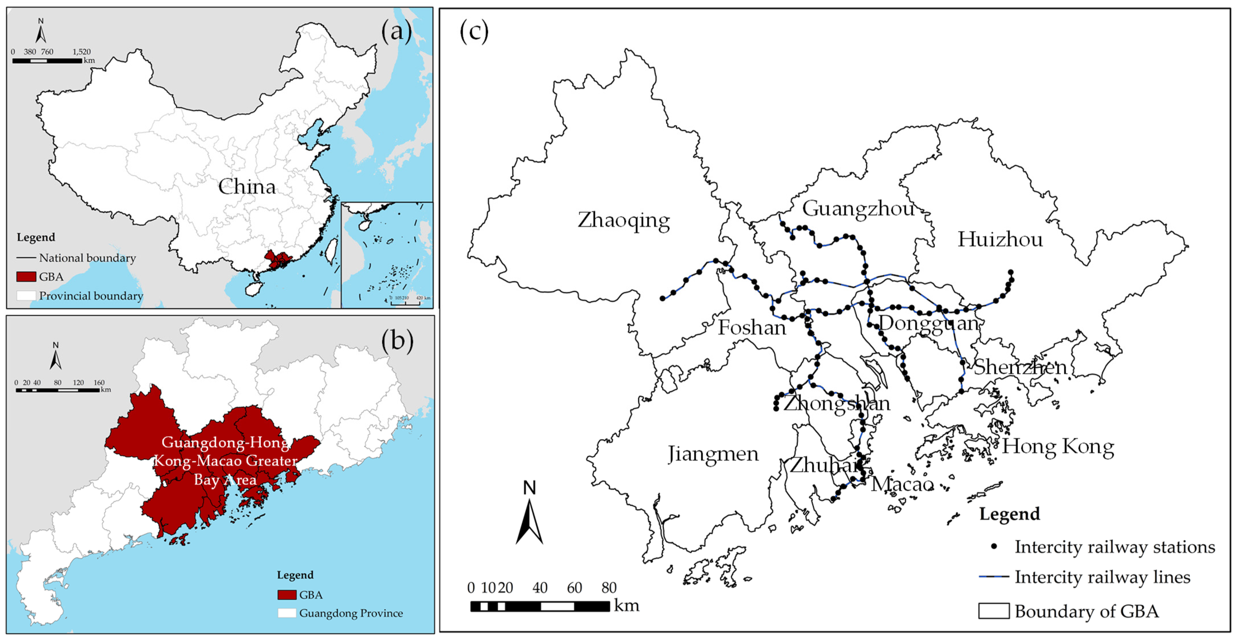
2.1. Research Area and Data Collection
2.1.1. Research Area
2.1.2. Data Collection
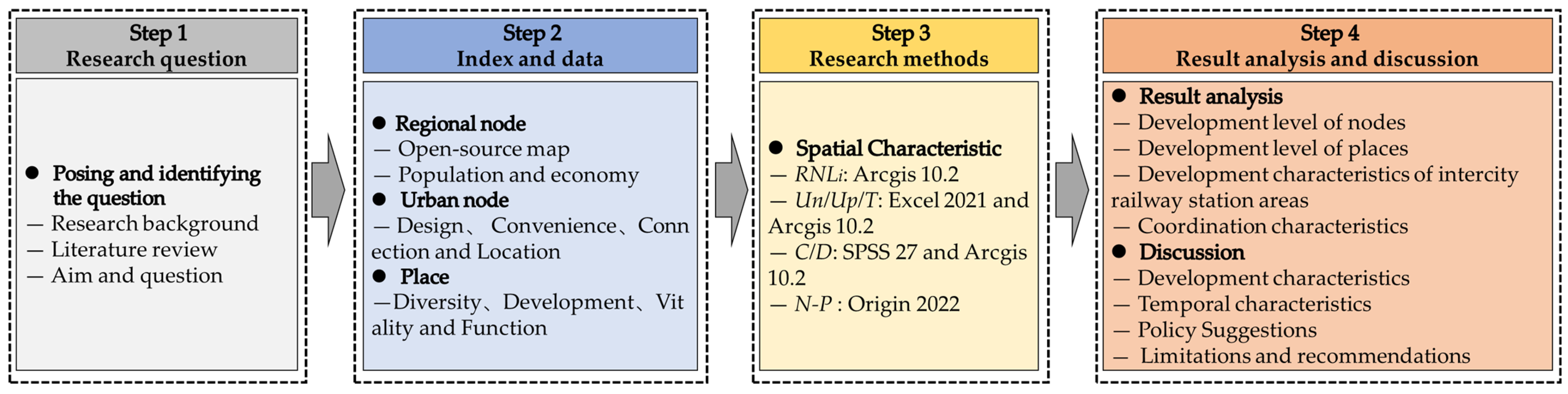
2.2. Research Steps
2.3. Research Methods
2.3.1. Node-Place
- (1)
- Node-Place Model (NP)
- (2)
- Node-place indicators

| First-Level Indicators | Second-Level Indicators | Third-Level Indicators | Formula and Description |
|---|---|---|---|
| Regional Node | Connecting Value | Regional node level (RNL) | Formula (1) and Formula (2) |
| Urban Node | Design | Station design scale (SDC) | SDC = assign values based on station track |
| Convenience | Supporting rate of subway facilities (SRSF) | SRSF = number of subway stations within 800 meters of the station (using GIS for zonal statistics as table) | |
| Supporting rate of public transportation facilities (SRPTF) | SRPTF = number of bus stops within 500 meters of the station GIS (using GIS for zonal statistics as table) | ||
| Convenience of subway connection(CSC) | CSC = subway service directions-one line service direction is assigned a value of 2 (using GIS for routes extraction and assignment) | ||
| Coordination of public transportation | The number of public transportation types connected to the station (bus, subway, taxi, ride hailing, etc.) | ||
| Connection | Train frequency | Total number of daily departures or stops of trains | |
| Location | Location index(LI) | LI = distance from the station to the city center (using GIS for location analysis) | |
| Place | Diversity | Proportion of industrial land (PIL) | PIL = Industrial land area/station area |
| Proportion of commercial land (PCL) | PCL = Commercial land area/station area | ||
| Proportion of service land (PSL) | PSL = Service land area/station area | ||
| Proportion of residential land (PRL) | PRL = Residential land area/station area | ||
| Proportion of leisure land (PLL) | PLL = Leisure land area/station area | ||
| Development | Development intensity (DI) | DI = Area of the Station area has been developed(using GIS for zonal statistics as table) | |
| Development progress (DP) | DP = Area of the Station area has been developed/station area | ||
| Vitality | Economic vitality (EV) | EV = POI density of the company and enterprise (using GIS for kernel density analysis) | |
| Population vitality (PV) | PV = POI density of residential buildings (using GIS for kernel density analysis) | ||
| Function | Functional density (FD) | FD = POI density (using GIS for kernel density analysis) | |
| Environmental Quality | Ecological quality index (EQI) | Abio-Normalization coefficient of ecological environment quality index (reference value is 494.8122); SF-Forest land index; SG-Grassland index; SW-Water and Wetland Index; SC -Cultivated land index; SB-Construction land index; SU-Unutilized land index; LA-regional land area [76] | |
| Social Equity | Fairness of public transportation station services (FPTSS) | Ti and Pi are the number of transportation stations and population scales in the station area; T and P are the number of stations and population scales of the city |
2.3.2. Development Index of Regional Nodes
2.3.3. Development Level Index
2.3.4. Coupling Coordination Degree Model
3. Results
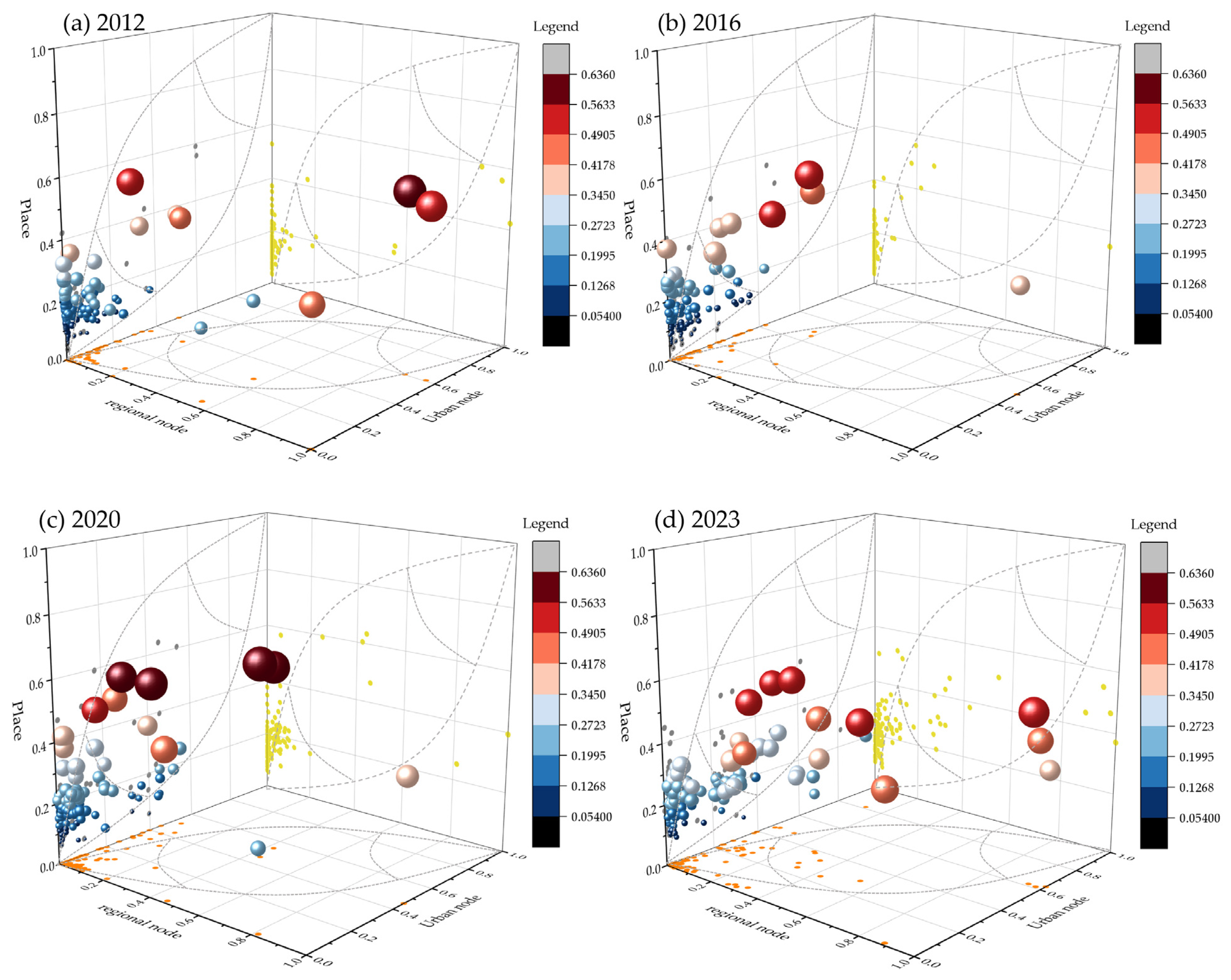
3.1. Development Level of Nodes
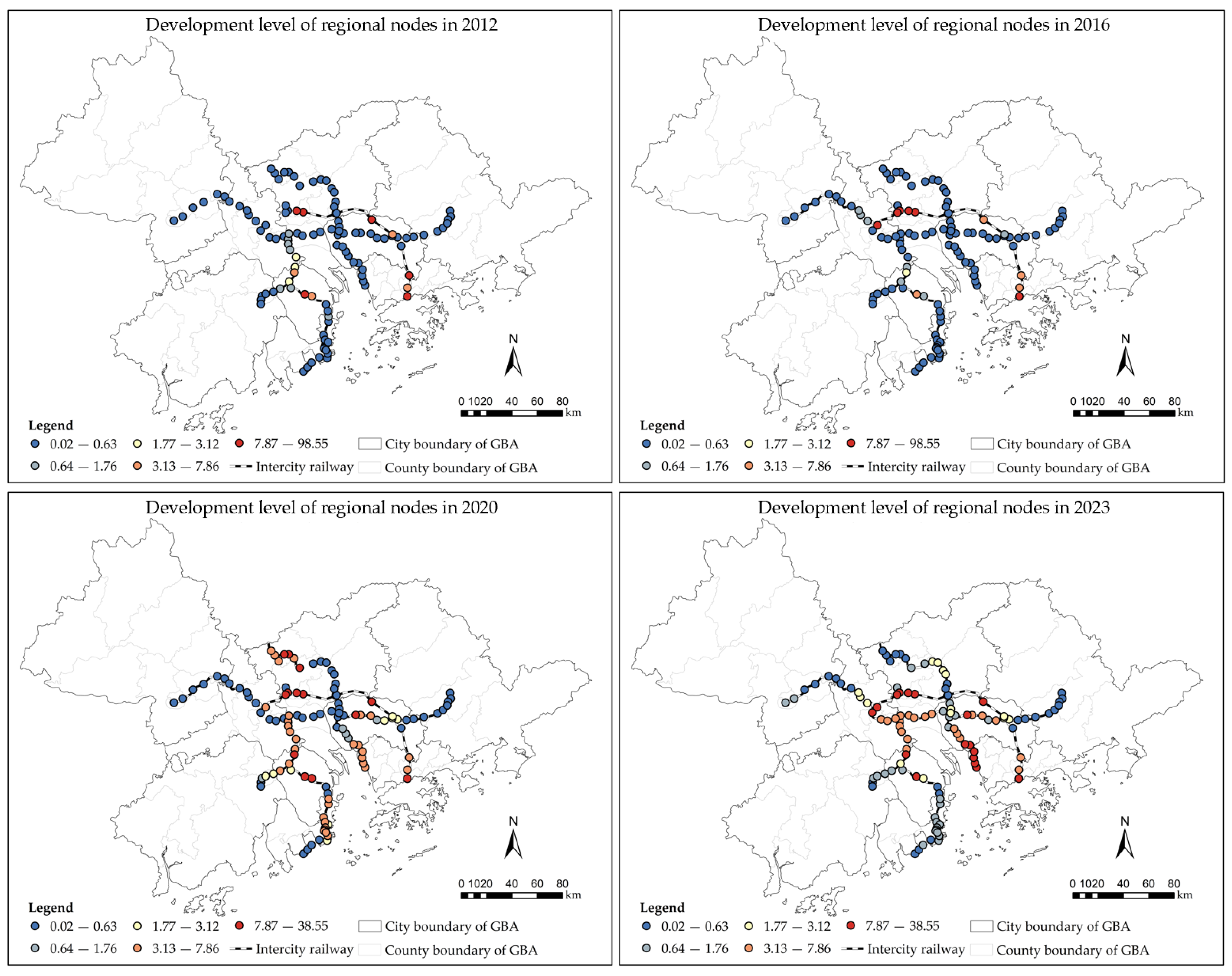
3.1.1. Development Level of Regional Nodes
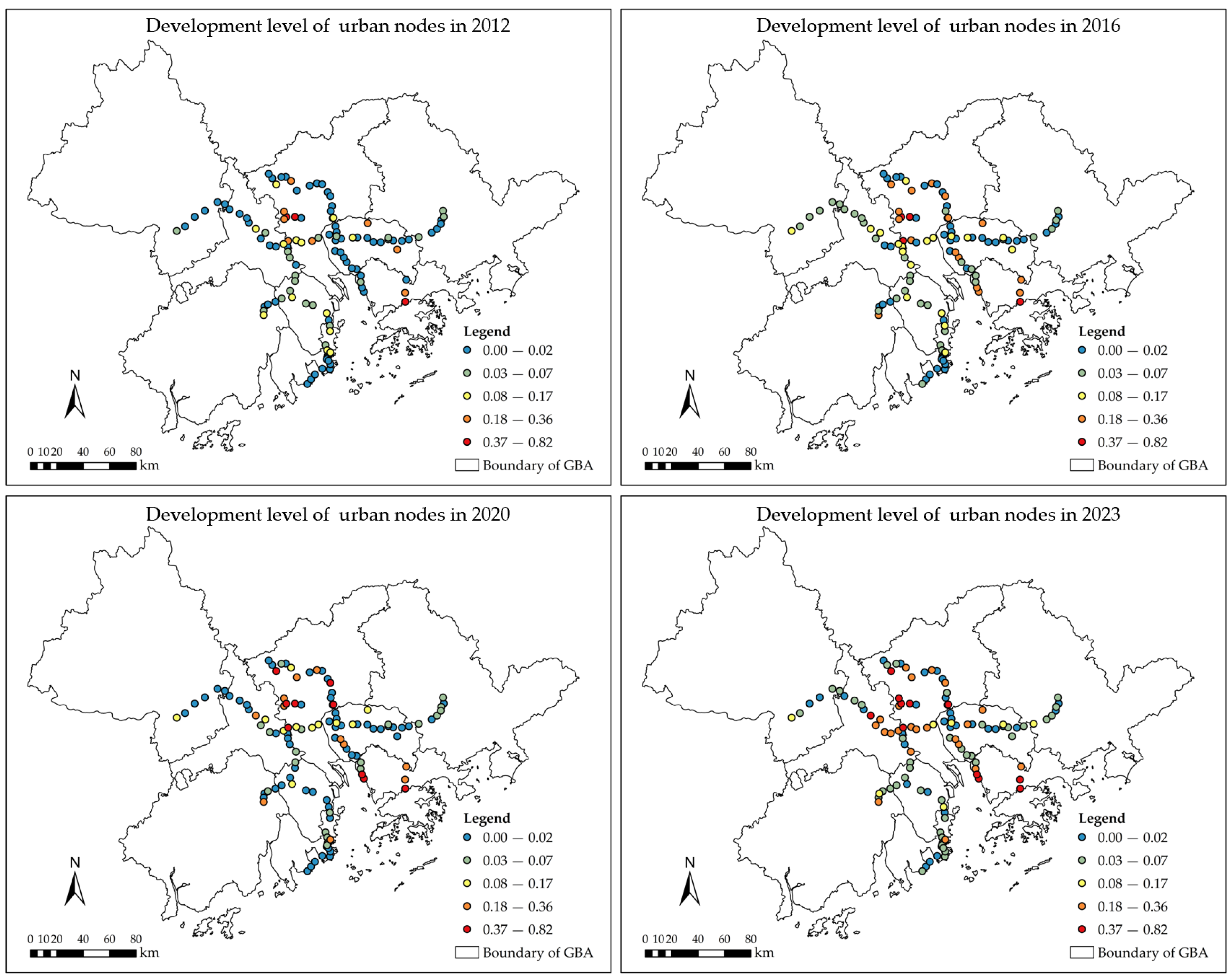
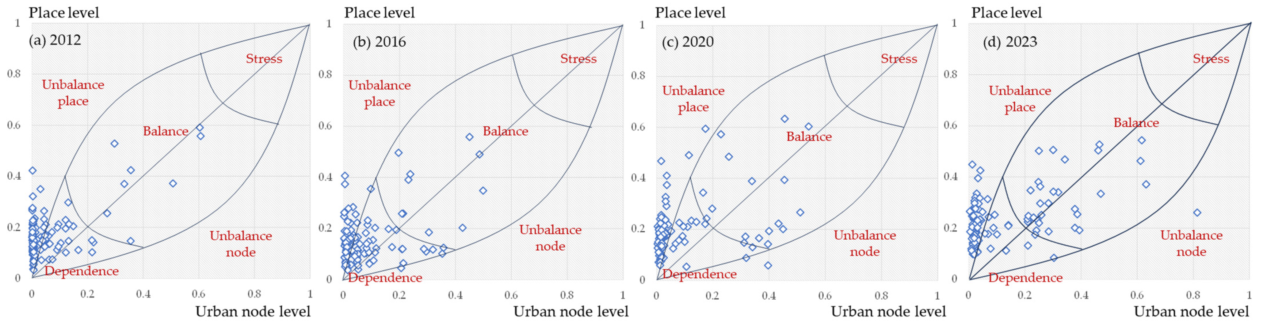
3.1.2. Development Level of Urban Nodes
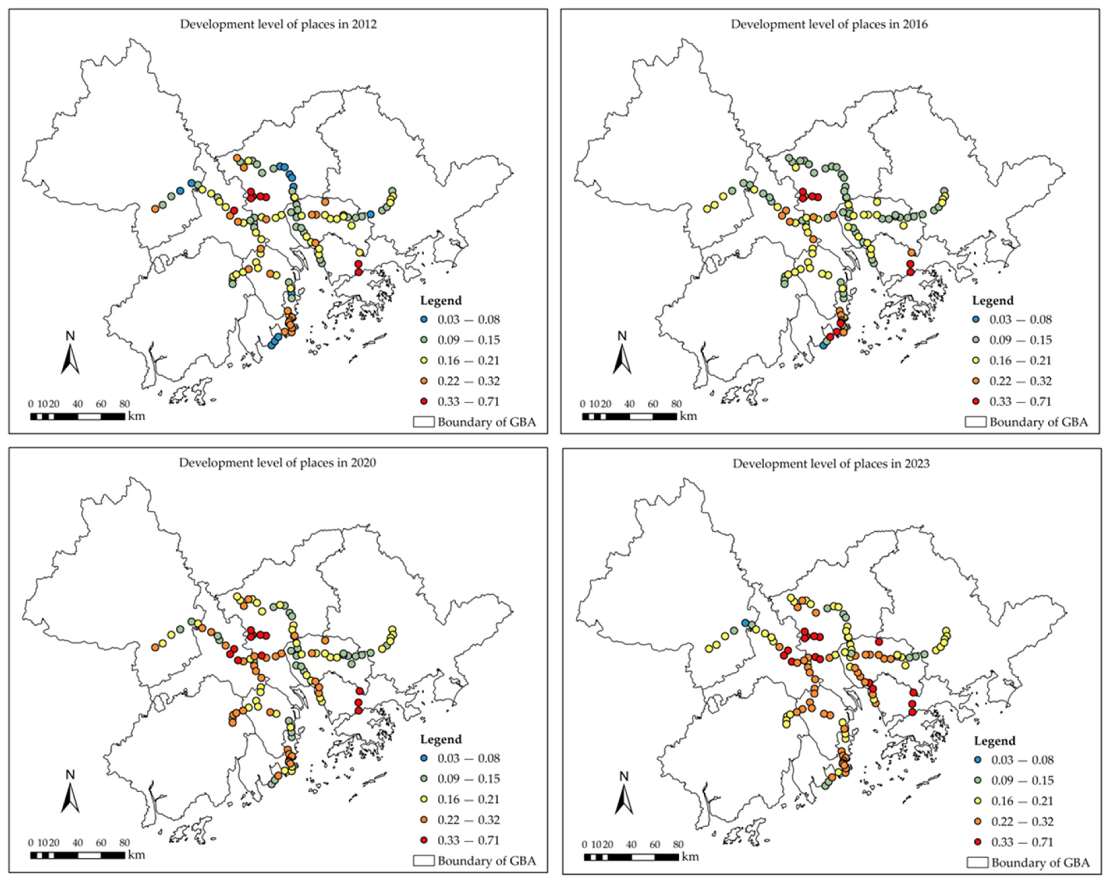
3.2. Development Level of Places
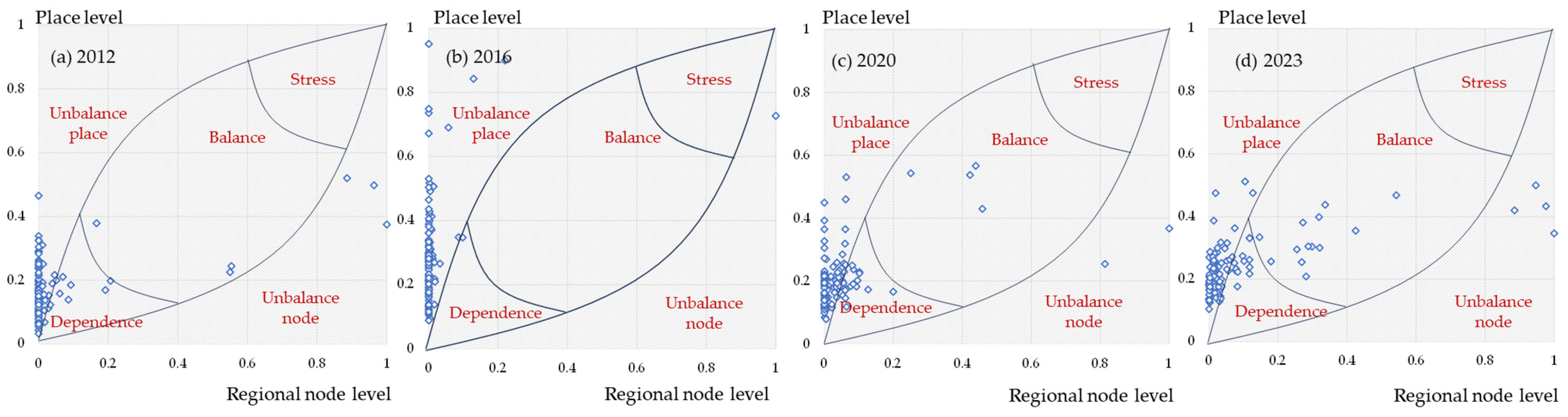
3.3. Development Characteristics of Intercity Railway Station Areas
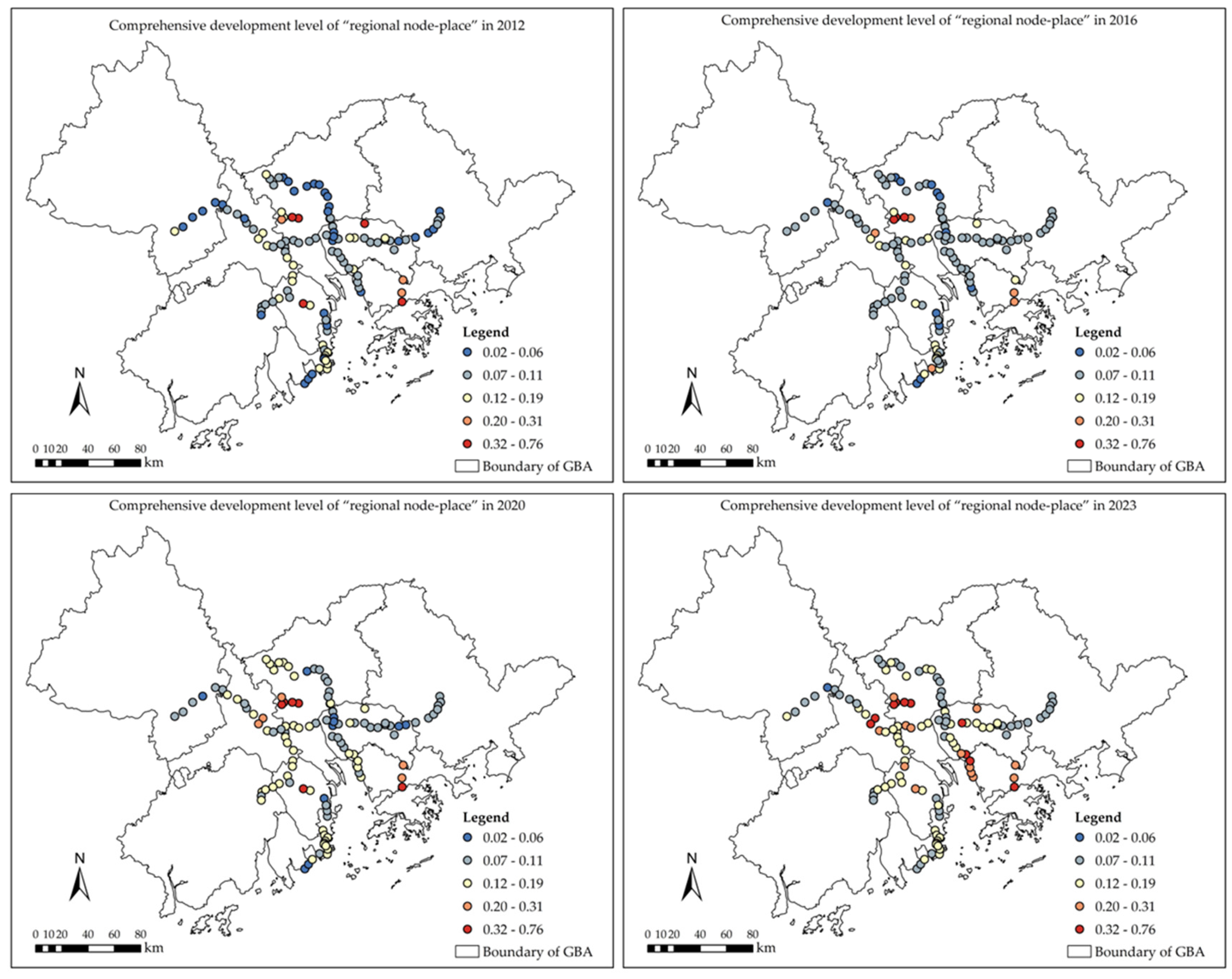
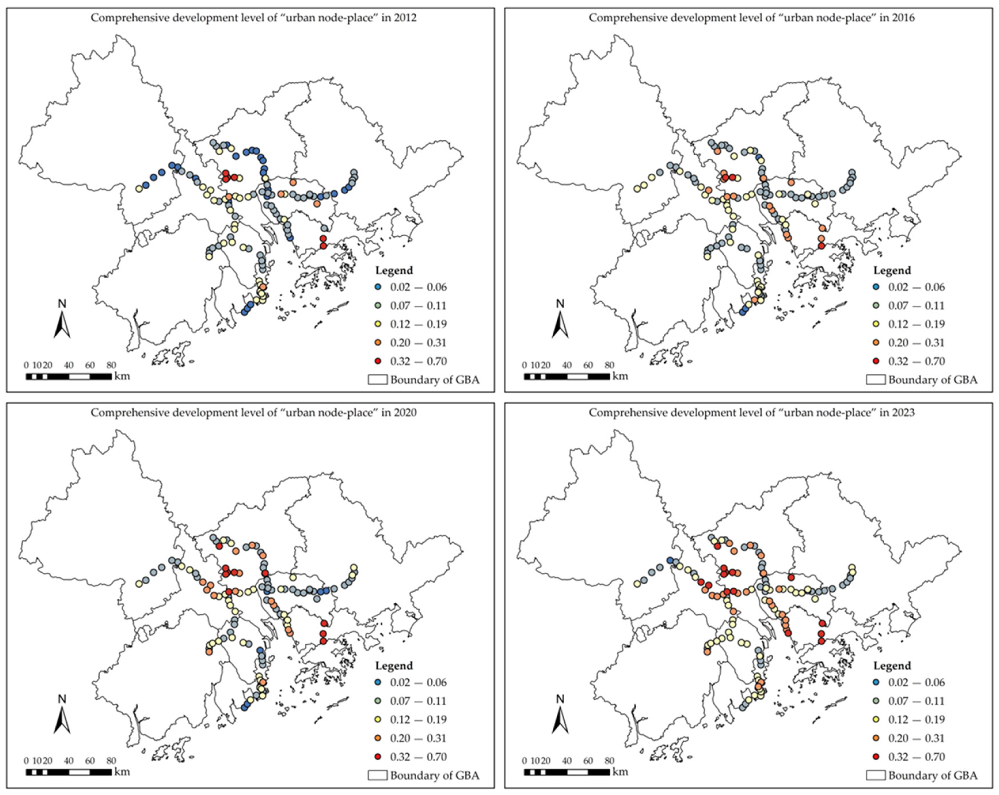
3.3.1. Comprehensive Development Level of Intercity Railway Station Areas
3.3.2. Characteristics of Development Types of Intercity Railway Station Areas
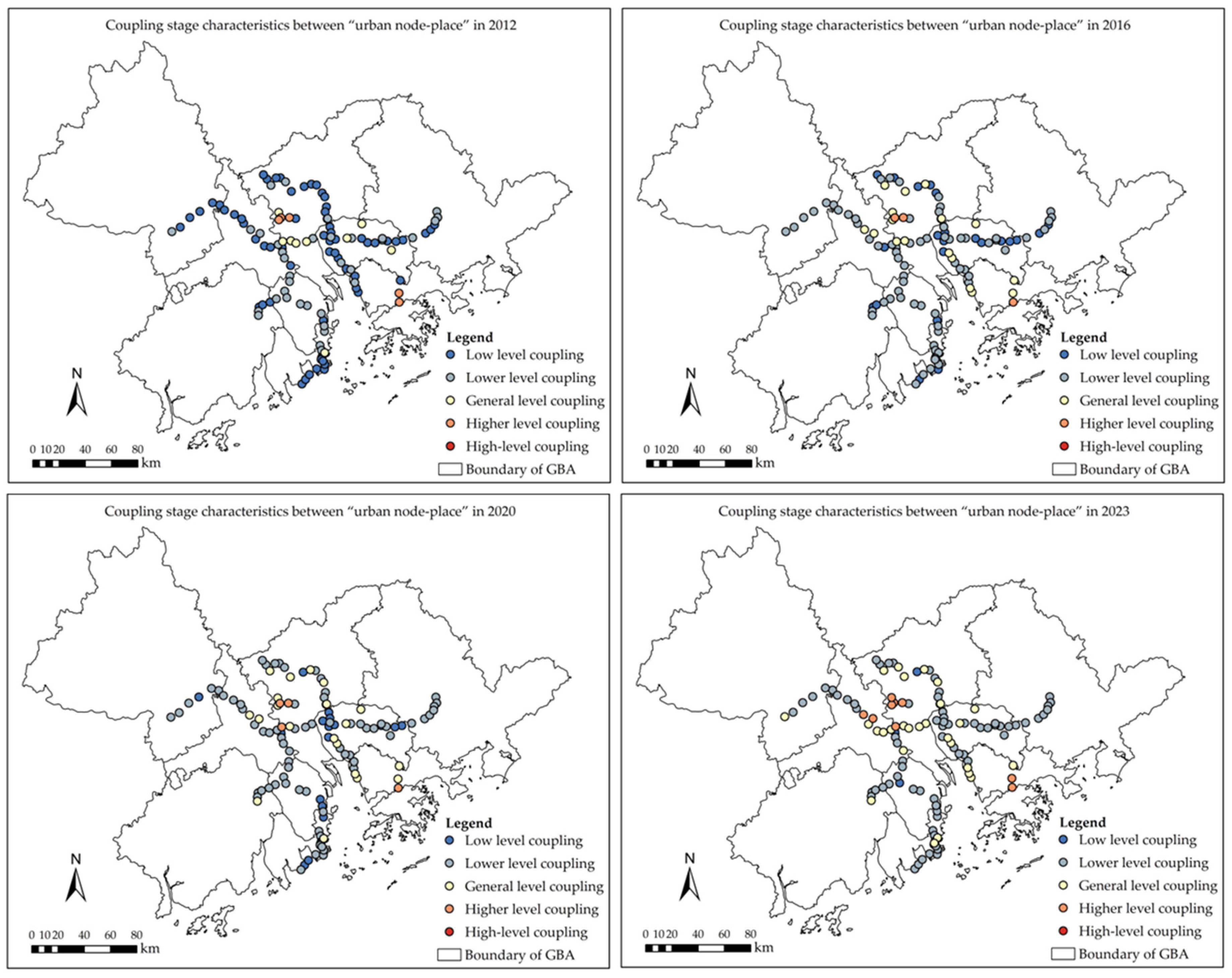
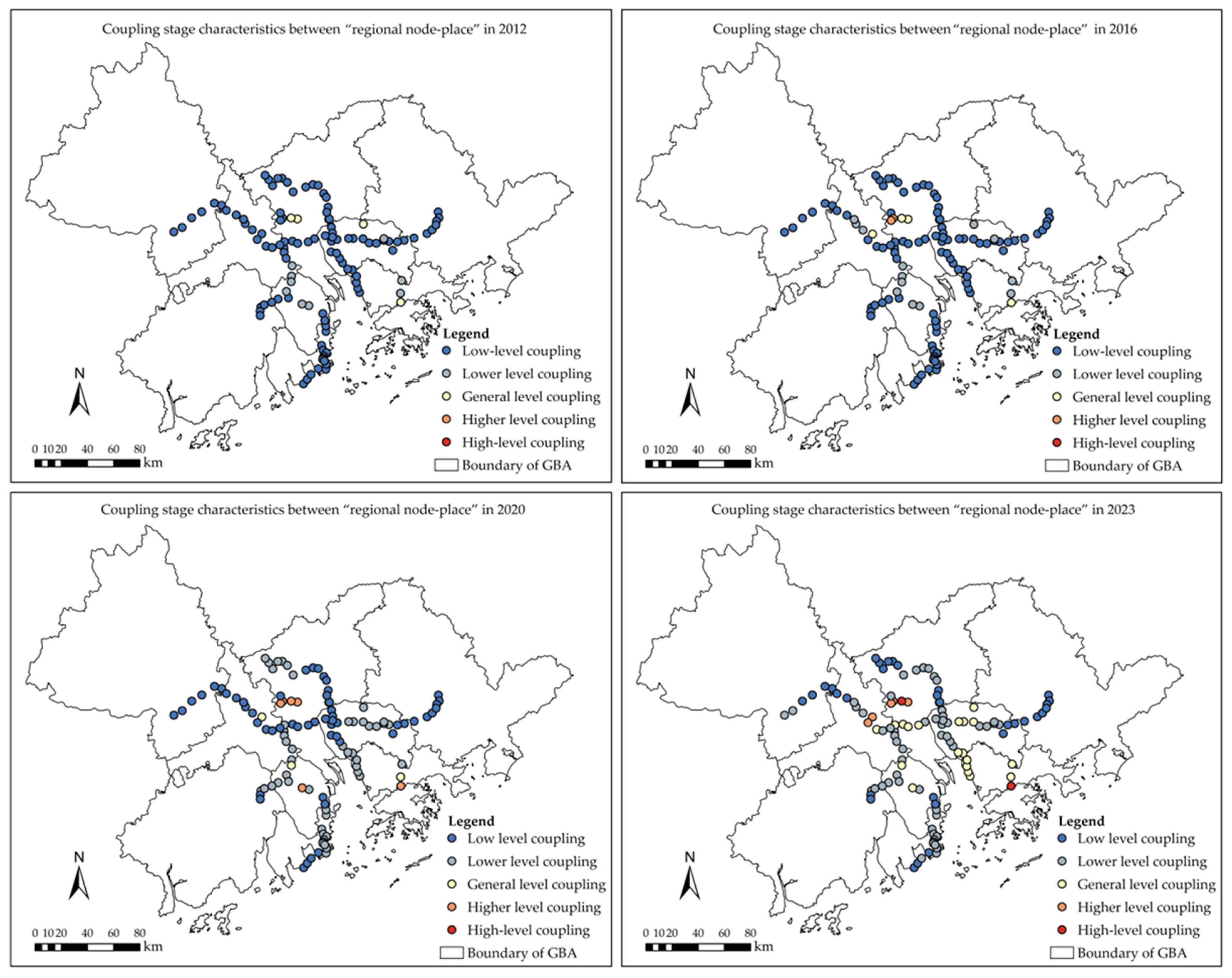
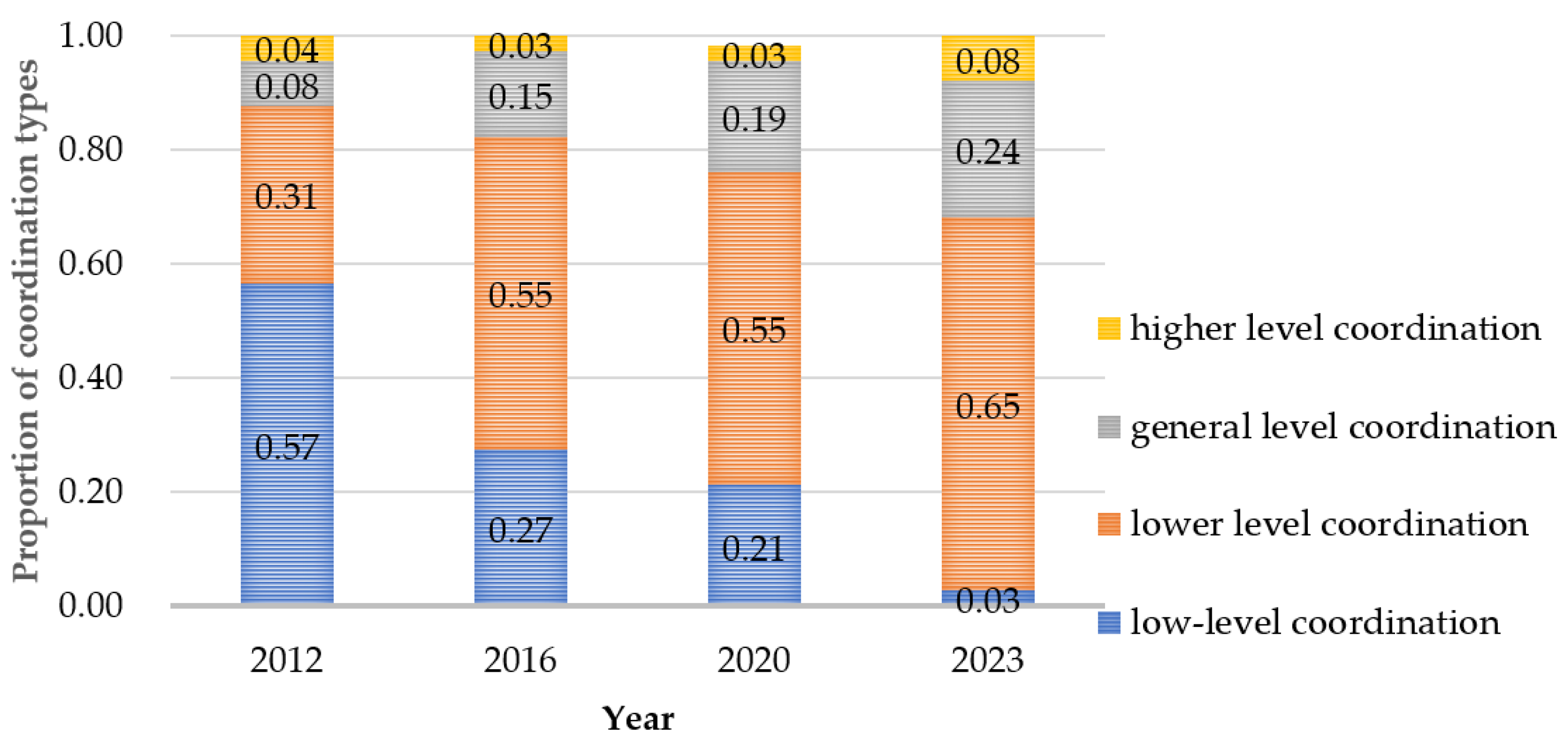
3.4. The Coupling and Coordination Characteristics of Node-Place
4. Discussion
4.1. Development Characteristics of Node-Place
4.2. Temporal Characteristics of Coordination Degree
4.3. Policy Suggestions of Sustainable Development
4.4. Limitations and Recommendations
5. Conclusions
Author Contributions
Funding
Data Availability Statement
Conflicts of Interest
References
- Jin, F.; Wang, C.; Cao, Y.; Cao, X.; Wang, J.; Dai, T.; Jiao, J. Progress of research on transportation geography in China. J. Geogr. Sci. 2016, 26, 1067–1080. [Google Scholar] [CrossRef]
- Huang, Z.D.; Michael, B.; Ye, J.A.; Chen, J.; Shi, W.Z.; Guo, R.Z. Synergy of Mega-City Clusters: Progress and Pathway. Geomat. World 2021, 28, 5–14. [Google Scholar] [CrossRef]
- Xu, Y.F.; Wang, D.G. Research progress and prospects of high-speed rail effects on urban spatial structure in China. Prog. Geogr. 2018, 37, 60–74. [Google Scholar] [CrossRef]
- Gao, Y.; Cui, X.; Sun, X. Land Use Characteristics of Commuter Rail Station Areas and Their Impact on Station Ridership: A Case Study of Japan Railways in the Tokyo Metropolitan Area. Land 2024, 13, 2045. [Google Scholar] [CrossRef]
- Hua, Z.; Li, C. The Enlightenment of the Development of Rail Transit in Tokyo Metropolitan Area to Shanghai Metropolitan Area. Shanghai Urban Manag. 2018, 27, 63–68. [Google Scholar] [CrossRef]
- National Development and Reform Commission. Reply on the Construction Plan of Intercity Railway in Guangdong-Hong Kong-Macao Greater Bay Area; National Development and Reform Commission: Beijing, China, 2020.
- Wei, S.; Wang, L. Classifying High-Speed Rail Stations in the Yangtze River Delta, China: The Node-Place Modelling Approach. Appl. Spat. Anal. Policy 2022, 16, 625–646. [Google Scholar] [CrossRef]
- Hou, X.; Zhang, W.X.; Lv, G.W.; Hu, Z.D. Study on the Influence of Regional Development around Station of HST-Taking Beijing South Station as an Example. Urban Dev. Stud. 2012, 19, 41–46. [Google Scholar] [CrossRef]
- Cao, X.S.; Li, L.N.; Wei, H. Investigating Intercity Rail Transit Scope with Social Economy Accessibility: Case Study of the Pearl River Delta Region in China. Urban Rail Transit 2017, 3, 61–71. [Google Scholar] [CrossRef]
- Diao, M.; Zhu, Y.; Zhu, J. Intra-city access to inter-city transport nodes: The implications of high-speed-rail station locations for the urban development of Chinese cities. Urban Stud. 2016, 54, 2249–2267. [Google Scholar] [CrossRef]
- Wang, F.; Liu, Z.; Xue, P.; Dang, A. High-speed railway development and its impact on urban economy and population: A case study of nine provinces along the Yellow River, China. Sustain. Cities Soc. 2022, 87, 104172. [Google Scholar] [CrossRef]
- Guo, N.N.; Yu, T. Research Pmgress and Reflection on the Spatal Effect of High-speed Raiway New Town. Mod. Urban Res. 2018, 8, 115–122. [Google Scholar] [CrossRef]
- Wang, J.X.; Lin, C.H. High-speed Rail and Its Impacts on the Urban Spatial Dynamics in China: The Background and Analytical Framework. Urban Plan. Int. 2011, 26, 16–23. [Google Scholar]
- Loo, B.P.Y.; Huang, Z. Location matters: High-speed railway (HSR) stations in city evolution. Cities 2023, 139, 104380. [Google Scholar] [CrossRef]
- Wang, S.J.; Mo, H.M.; Lv, H.N.; Xu, P.Y.; Yin, H.Q. Industrial structure of high-speed railway station areas under the influence of location: Empirical evidences from POI data. Acta Geogr. Sin. 2021, 76, 2016–2031. [Google Scholar] [CrossRef]
- Zou, Z.; Tang, Y. Evaluation of Sustainable Development Potential of High-Speed Railway Station Areas Based on “Node-Place-Industry” Model. ISPRS Int. J. Geo-Inf. 2023, 12, 349. [Google Scholar] [CrossRef]
- Yin, M.; Tang, J.; Duan, J. The Synergy of High-speed Railway Station Areas and Urban Space Development. Urban Plan. Int. 2013, 28, 70–77. [Google Scholar]
- Chen, C.L.; Hall, P. The wider spatial-economic impacts of high-speed trains: A comparative case study of Manchester and Lille sub-regions. J. Transp. Geogr. 2012, 24, 89–110. [Google Scholar] [CrossRef]
- Vale, D.S.; Viana, C.M.; Pereira, M. The extended node-place model at the local scale: Evaluating the integration of land use and transport for Lisbon’s subway network. J. Transp. Geogr. 2018, 69, 282–293. [Google Scholar] [CrossRef]
- Liu, B.K.; Feng, C.C. Research of Impact of Urban Railway Transportation on Land Use Structure Based on GIS and Information Entropy. Urban Dev. Stud. 2016, 16, 149–155. [Google Scholar] [CrossRef]
- Zhang, Y.; Cao, K.; He, Y.W.; Zhou, W. Discussion on spatial match between land use and rail transit:A case study of Shenzhern subway line 2. City Plan. Rev. 2017, 14, 107–115. [Google Scholar]
- Tan, Z.Y.; Li, S.Y.; Li, X.; Liu, X.P.; Chen, Y.M.; Li, W.X. Spatio-temporal effects of urban rail transit on complex land-use change. Acta Geogr. Sin. 2017, 72, 850–862. [Google Scholar] [CrossRef]
- Lin, X.Y. High Speed Railway and New Structure of Social-Economic Development; Social Sciences Academic Press: Beijing, China, 2017. [Google Scholar]
- Baghestani, A.; Najafabadi, S.; Salem, A.; Jiang, Z.; Tayarani, M.; Gao, O. An Application of the Node–Place Model to Explore the Land Use–Transport Development Dynamics of the I-287 Corridor. Urban Sci. 2023, 7, 21. [Google Scholar] [CrossRef]
- Yang, Y.L.; Han, S.S. Functional Integration and Strategic Planning: A Review of Studies on High-speed Rail Station and Urban Development. Urban Plan. Int. 2019, 35, 102–108. [Google Scholar] [CrossRef]
- Cummings, C.; Mahmassani, H. Does intercity rail station placement matter? Expansion of the node-place model to identify station location impacts on Amtrak ridership. J. Transp. Geogr. 2022, 99, 103278. [Google Scholar] [CrossRef]
- Su, S.L.; Zhang, H.; Wang, M.; Weng, M.; Kang, M.J. Transit-oriented development (TOD) typologies around metro station areas in urban China: A comparative analysis of five typical megacities for planning implications. J. Transp. Geogr. 2021, 90, 102939. [Google Scholar] [CrossRef]
- Moyano, A.; Martínez, H.S.; Coronado, J.M. From network to services: A comparative accessibility analysis of the Spanish high-speed rail system. Transp. Policy 2018, 63, 51–60. [Google Scholar] [CrossRef]
- Vale, D.S. Transit-oriented development, integration of land use and transport, and pedestrian accessibility: Combining node-place model with pedestrian shed ratio to evaluate and classify station areas in Lisbon. J. Transp. Geogr. 2015, 45, 70–80. [Google Scholar] [CrossRef]
- Jia, X.; Wang, J.; Yan, B. Evaluation of existing underground public space supply based on the Node-Place-Experience model. Tunn. Undergr. Space Technol. 2024, 144, 105517. [Google Scholar] [CrossRef]
- Lu, L.; Deng, H.B. Progress and Prospect of the Node-Place Model and Its Application. Sci. Geogr. Sin. 2019, 39, 12–21. [Google Scholar] [CrossRef]
- Yin, M.; Bertolini, L.; Duan, J. The effects of the high-speed railway on urban development: International experience and potential implications for China. Prog. Plan. 2015, 98, 1–52. [Google Scholar] [CrossRef]
- Liu, X.; Chen, X.H.; Pan, H.X. From “Station-City Integration” to “Corridor Integration”: TOD Framework and Model Optimization from the Perspective of Space of Flows. Urban Plan. Forum. 2024, 4, 34–40. [Google Scholar] [CrossRef]
- Deng, Y.Y.; Chang, J.; Zhuo, X. A Summary on TOD Research at Home and Abroad DuringRecent Two Decades——An Analysis Based on the Visual Analysis into CitespaceSoftware. Mod. Urban Res. 2019, 2, 41–46. [Google Scholar] [CrossRef]
- Xia, Z.W.; Zhang, Y. From “5D” to “5D+N”: Research Published in English on the Factors Influencing TOD Performance. Urban Plan. Int. 2019, 34, 109–116. [Google Scholar] [CrossRef]
- Huang, J.Z.; Cao, J.Z.; Wan, K. Development of the TOD Theory and Future Research Prospects in the New Technological Environment. Urban Plan. Forum 2023, 2, 40–46. [Google Scholar] [CrossRef]
- Groenendijk, L.; Rezaei, J.; Correia, G. Incorporating the travellers’ experience value in assessing the quality of transit nodes: A Rotterdam case study. Case Stud. Transp. Policy 2018, 6, 564–576. [Google Scholar] [CrossRef]
- Du, J.; Druta, O.; Van Wesemael, P. Place quality in high-speed rail station areas: Concept definition. J. Transp. Land Use 2021, 14, 1165–1186. [Google Scholar] [CrossRef]
- Li, P.Y.; Ge, Y.S. Evaluating Sustainable Development of High-Speed Railway Station Areas via Node-Place Model: A Case Study of Beijing-Shanghai High-Speed Railway Stations. Urban Transp. China 2022, 20, 59–66+82. [Google Scholar] [CrossRef]
- Ortuño-Padilla, A.; Espinosa-Flor, A.; Cerdán-Aznar, L. Development strategies at station areas in southwestern China: The case of Mianyang city. Land Use Policy 2017, 68, 660–670. [Google Scholar] [CrossRef]
- Lyu, G.; Bertolini, L.; Pfeffer, K. Developing a TOD typology for Beijing metro station areas. J. Transp. Geogr. 2016, 55, 40–50. [Google Scholar] [CrossRef]
- Sung, H.; Oh, J.T. Transit-oriented development in a high-density city: Identifying its association with transit ridership in Seoul, Korea. Cities 2011, 28, 70–82. [Google Scholar] [CrossRef]
- Higgins, C.D.; Kanaroglou, P.S. A latent class method for classifying and evaluating the performance of station area transit-oriented development in the Toronto region. J. Transp. Geogr. 2016, 52, 61–72. [Google Scholar] [CrossRef]
- Hu, S.; He, Z.; Wu, L.; Yin, L.; Xu, Y.; Cui, H. A framework for extracting urban functional regions based on multiprototype word embeddings using points-of-interest data. Comput. Environ. Urban Syst. 2020, 80, 101442. [Google Scholar] [CrossRef]
- Shaw, S.L.; Tsou, M.H.; Ye, X.Y. Editorial: Human dynamics in the mobile and big data era. Int. J. Geogr. Inf. Sci. 2016, 30, 1687–1693. [Google Scholar] [CrossRef]
- Shan, Z.R.; An, Y.H.; Yuan, M.; Huang, Y.P. Study on Spatial and Temporal Distribution Characteristics and Influencing Factors of Urban Residents’ Sentiment Based on Weibo Data: A Case Study of the Main Urban Area of Wuhan. Urban Dev. Stud. 2022, 29, 69–76+62. [Google Scholar] [CrossRef]
- Pezeshknejad, P.; Monajem, S.; Mozafari, H. Evaluating sustainability and land use integration of BRT stations via extended node place model, an application on BRT stations of Tehran. J. Transp. Geogr. 2020, 82, 102626. [Google Scholar] [CrossRef]
- Bertolini, L. Nodes and Places: Complexities of railway station redevelopment. Eur. Plan. Stud. 1996, 4, 331–345. [Google Scholar] [CrossRef]
- Zou, Z.J.; He, Z.; Chen, H.H. Evaluating the development potential of areas surrounding high-speed railway stations: An empirical analysis for Wuhan—Guangzhou passenger corridor line. J. Railw. Sci. Eng. 2016, 13, 2125–2132. [Google Scholar] [CrossRef]
- Phani Kumar, P.; Ravi Sekhar, C.; Parida, M. Identification of neighborhood typology for potential transit-oriented development. Transp. Res. Part D Transp. Environ. 2020, 78, 102186. [Google Scholar] [CrossRef]
- Ibraeva, A.; Correia, G.H.D.A.; Silva, C.; Antunes, A.P. Transit-oriented development: A review of research achievements and challenges. Transp. Res. Part A Policy Pract. 2020, 132, 110–130. [Google Scholar] [CrossRef]
- Zhang, Y.; Song, R.; Van Nes, R.; He, S.; Yin, W. Identifying Urban Structure Based on Transit-Oriented Development. Sustainability 2019, 11, 7241. [Google Scholar] [CrossRef]
- Singh, Y.J.; Lukman, A.; Flacke, J.; Zuidgeest, M.; Van Maarseveen, M.F.A.M. Measuring TOD around transit nodes—Towards TOD policy. Transp. Policy 2017, 56, 96–111. [Google Scholar] [CrossRef]
- Ibrahim, S.M.; Ayad, H.M.; Turki, E.A.; Saadallah, D.M. Measuring Transit-Oriented Development (TOD) levels: Prioritize potential areas for TOD in Alexandria, Egypt using GIS-Spatial Multi-Criteria based model. Alex. Eng. J. 2023, 67, 241–255. [Google Scholar] [CrossRef]
- Sun, Y.; Han, B.; Lu, F. An Overview of TOD Level Assessment Around Rail Transit Stations. Urban Rail Transit 2024, 10, 1–12. [Google Scholar] [CrossRef]
- Gui, W.Z.; Zhang, X.; Wang, A. Research on spatial planning evaluation of Beijing Shanghai high speed railway station based on node-place model. J. Intell. Fuzzy Syst. 2021, 40, 733–743. [Google Scholar] [CrossRef]
- Song, W.J.; Shi, Y.J.; Zhu, J.; Zhang, W.X.; Ding, J.X. Evaluation on Planning of High-Speed Rail Station Area Based on Node-Place Model in Yangtze River Delta Area. Econ. Geogr. 2016, 36, 18–25+38. [Google Scholar] [CrossRef]
- Kim, J.S.; Shin, N. Planning for Railway Station Network Sustainability Based on Node–Place Analysis of Local Stations. Sustainability 2021, 13, 4778. [Google Scholar] [CrossRef]
- Di Matteo, D.; Mariotti, I.; Rossi, F. Transport infrastructure and economic performance: An evaluation of the Milan-Bologna high-speed rail corridor. Socio-Econ. Plan. Sci. 2023, 85, 101304. [Google Scholar] [CrossRef]
- Guo, J.; Nakamura, F.; Li, Q.; Zhou, Y. Efficiency Assessment of Transit-Oriented Development by Data Envelopment Analysis: Case Study on the Den-en Toshi Line in Japan. J. Adv. Transp. 2018, 2018, 6701484. [Google Scholar] [CrossRef]
- Ma, X.; Chen, X.; Li, X.; Ding, C.; Wang, Y. Sustainable station-level planning: An integrated transport and land use design model for transit-oriented development. J. Clean. Prod. 2018, 170, 1052–1063. [Google Scholar] [CrossRef]
- Xu, W.A.; Guthrie, A.; Fan, Y.; Li, Y. Transit-oriented development: Literature review and evaluation of TOD potential across 50 Chinese cities. J. Transp. Land Use 2017, 10, 743–762. [Google Scholar] [CrossRef]
- Deng, L.K.; Shi, Y.L.; Zhang, H.; Wang, Y.F. Research on spatial network of intercity railway station in urban agglomeration. Urban Dev. Stud. 2017, 24, 74–70+99. [Google Scholar]
- Guo, X.Y.; Mu, X.Q.; Ding, Z.S.; Ming, Q.Z. The coordination pattern of tourism efficiency and high-speed transportation: A case study of 41 cities in the Yangtze River Delta. Geogr. Res. 2021, 40, 1042–1063. [Google Scholar] [CrossRef]
- Cao, Y.; Yu, L.; Li, S.T. Spatial evolution of high-speed railway station areas and planning response. City Plan. Rev. 2020, 44, 88–96. [Google Scholar]
- Wang, L.; Cao, Y.H.; Liu, K.W.; Wang, C. Spatial Distribution and Clusters of Industry Nearby High-speed Rail Station: The case of Nanjing Station, Shanghai-Nanjing Motor Train. Sci. Geogr. Sin. 2012, 32, 301–307. [Google Scholar] [CrossRef]
- Zhou, W.Z.; Yang, J.Q. Space development mechanism of transit-oriented inter-city railway station area. City Plan. Rev. 2010, 34, 88–92. [Google Scholar]
- Wang, X.; Liu, J.; Zhang, W. How Does the Spatial Structure of High-Speed Rail Station Areas Evolve? A Case Study of Zhengzhou East Railway Station, China. Appl. Sci. 2021, 11, 11132. [Google Scholar] [CrossRef]
- Pan, H.Z.; Cong, C.; Zhang, X.L.; Zhang, Y.N. How do high-speed rail projects affect the agglomeration in cities and regions? Transp. Res. Part D Transp. Environ. 2020, 88, 102561. [Google Scholar] [CrossRef]
- Wang, J.; Lu, H.P.; Zeng, J. Integrated transfer system of hign-speed rail hub based on sustainable transfer. City Plan. Rev. 2014, 38, 71–77. [Google Scholar] [CrossRef]
- Duan, J.; Yin, M. Study on the relationship between planning layout of high-speed railway stations and transfer space convenient level: An empirical study of Yangtze River Delta Region. City Plan. Rev. 2014, 38, 44–50. [Google Scholar] [CrossRef]
- Caset, F.; Vale, D.S.; Viana, C.M. Measuring the Accessibility of Railway Stations in the Brussels Regional Express Network: A Node-Place Modeling Approach. Netw. Spat. Econ. 2018, 18, 495–530. [Google Scholar] [CrossRef]
- Li, Q.; Xu, Z. Guidance and reaction of inter-city railway on spatial development in urban agglomerations: A study on the regional transportation support in Ningbo Urban Development Strategy 2030. City Plan. Rev. 2012, 36, 92–96. [Google Scholar]
- Monajem, S.; Ekram Nosratian, F. The evaluation of the spatial integration of station areas via the node place model; an application to subway station areas in Tehran. Transp. Res. Part D Transp. Environ. 2015, 40, 14–27. [Google Scholar] [CrossRef]
- Zemp, S.; Stauffacher, M.; Lang, D.J.; Scholz, R.W. Classifying railway stations for strategic transport and land use planning: Context matters! J. Transp. Geogr. 2011, 19, 670–679. [Google Scholar] [CrossRef]
- Ministry of Ecology and Environment of the People’s Republic of China. Regional Ecological Quality Evaluation Method; Ministry of Ecology and Environment of the People’s Republic of China: Beijing, China, 2021.
- Gutiérrez, J.; Condeço-Melhorado, A.; Martín, J.C. Using accessibility indicators and GIS to assess spatial spillovers of transport infrastructure investment. J. Transp. Geogr. 2010, 18, 141–152. [Google Scholar] [CrossRef]
- He, X.Z.; Guo, X.C.; Zhang, X.H. High-speed Rail Passenger Distributing Patterns and Development Strategies. Urban Transp. China 2014, 12, 41–47. [Google Scholar] [CrossRef]
- Liu, Y.Y.; Wang, S.Q.; Wang, X.B. Flood risk assessment in Bangladesh, India and Myanmar based on the AHP weight method and entropy weight methodel. Geogr. Res. 2020, 39, 1892–1906. [Google Scholar] [CrossRef]
- Wang, D.G.; Sun, F. Geographic Patterns and Coupling-coordination Between Urbanization and Land Transportation Accessibility in the Yangtze River Economic Zone. Sci. Geogr. Sin. 2018, 38, 1089–1097. [Google Scholar] [CrossRef]
- Luo, Z.; Xu, A.; Gao, S. Research on the Coupling Coordination Relationship Between Tourism Carrying Capacity and the High-Speed Railway Network: A Case Study in China. IEEE Access 2023, 11, 20426–20444. [Google Scholar] [CrossRef]
- Zhuang, S.; Xia, N.; Gao, X.; Zhao, X.; Liang, J.; Wang, Z.; Li, M. Coupling coordination analysis between railway transport accessibility and tourism economic connection during 2010–2019: A case study of the Yangtze River Delta. Res. Transp. Bus. Manag. 2024, 55, 101134. [Google Scholar] [CrossRef]
- Zou, M.; Li, C.; Xiong, Y. Analysis of Coupling Coordination Relationship between the Accessibility and Economic Linkage of a High-Speed Railway Network Case Study in Hunan, China. Sustainability 2022, 14, 7550. [Google Scholar] [CrossRef]
- Yang, J.; Guo, A.; Li, X.; Huang, T. Study of the Impact of a High-Speed Railway Opening on China’s Accessibility Pattern and Spatial Equality. Sustainability 2018, 10, 2943. [Google Scholar] [CrossRef]
- Jia, S.; Zhou, C.; Qin, C. No difference in effect of high-speed rail on regional economic growth based on match effect perspective? Transp. Res. Part A Policy Pract. 2017, 106, 144–157. [Google Scholar] [CrossRef]
- Liu, H.; Zhang, Y.; Zheng, S.W. Evaluation on spatio temporal development and interaction of intensive urban land use and urbanization:Case studies of the cities in the Bohai Rim Region. Geogr. Res. 2011, 30, 1805–1817. [Google Scholar] [CrossRef]
- Teng, L.; Zhong, C.J.; Cai, D. Study on the Spatial Type Differentiation of Guangzhou Metro TOD Zones: Based on “Node-Place-Linkage” Coupling Model. Econ. Geogr. 2022, 42, 103–111. [Google Scholar] [CrossRef]
- Yang, W.; Yan, W.; Chen, L.; Li, H. From city center to suburbs: Developing a timeline-based TOD assessment model to explore the dynamic changes in station areas of Tokyo metropolitan area. Environ. Plan. B: Urban Anal. City Sci. 2024, 52, 214–230. [Google Scholar] [CrossRef]
- Ortega, E.; López, E.; Monzón, A. Territorial cohesion impacts of high-speed rail at different planning levels. J. Transp. Geogr. 2012, 24, 130–141. [Google Scholar] [CrossRef]
- Zheng, W.; Wei, S. A ‘node-place-network-city’ framework to examine HSR station area development dynamics: Station typologies and development strategies. J. Transp. Geogr. 2024, 120, 103993. [Google Scholar] [CrossRef]
- Yang, Y.; Zhong, C.; Gao, Q.L. An extended node-place model for comparative studies of transit-oriented development. Transp. Res. Part D Transp. Environ. 2022, 113, 103514. [Google Scholar] [CrossRef]

| Concept | Definitions |
|---|---|
| Regional node | Regional nodes of intercity railways refer to nodes in the intercity railway network, whose status and development potential reflect the influence and function of the station on the entire network [63]. |
| Urban node | Urban nodes refer to intercity railway stations that undertake fundamental transportation functions such as passenger collection and distribution, traffic connection, and transfer [10]. |
| Place | Places in the intercity railway station areas refer to the multifunctional space formed in a certain range around the intercity railway station as the core [38]. |
| Regional node-place | Used to reflect the development characteristics and coordination relations between regional nodes and places of intercity railway. |
| Urban node-place | Used to reflect the development characteristics and coordination relations between urban nodes and places of intercity railway. |
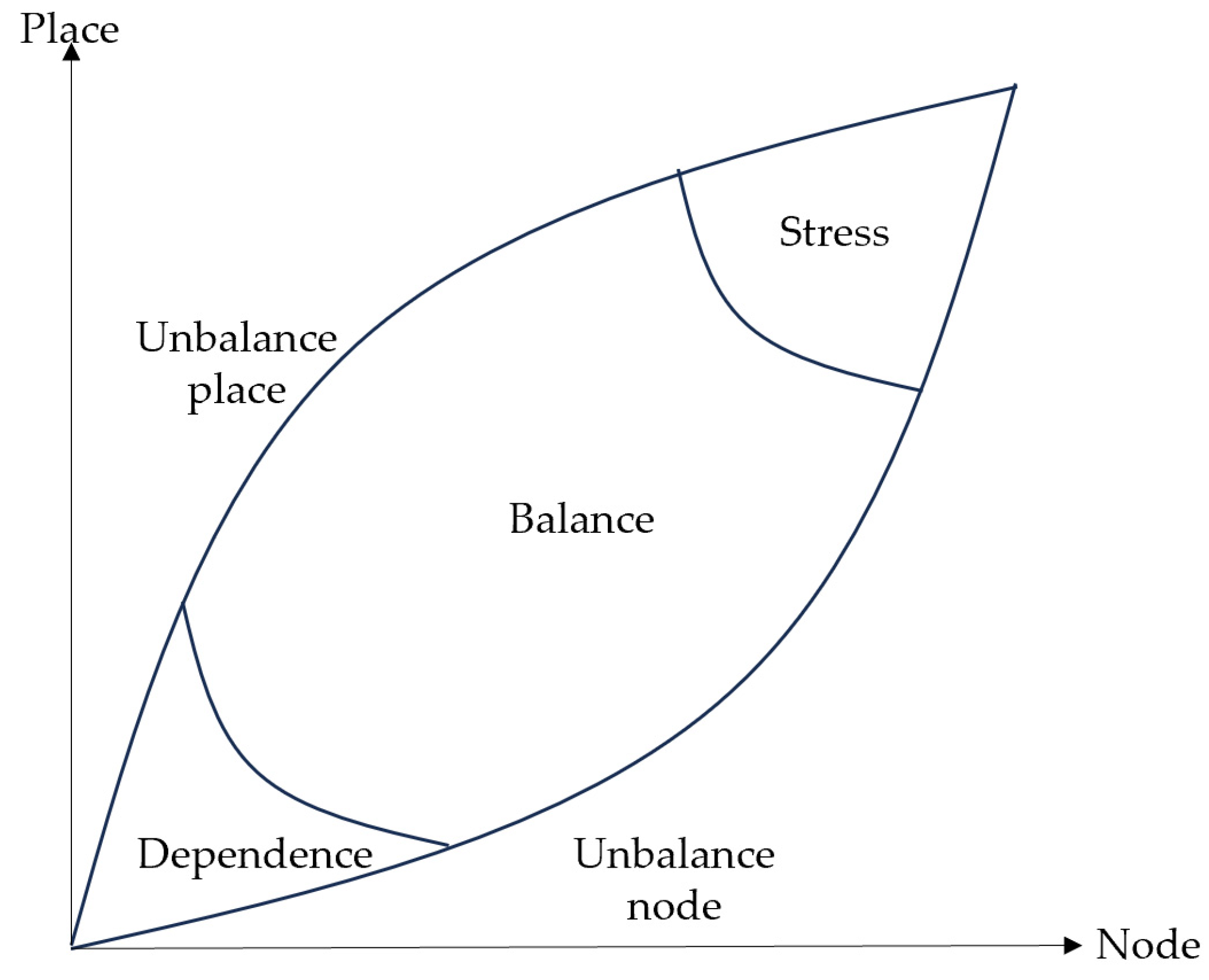
| Dependence, unbalance node, unbalance place, balance, and stress | Five developmental states between nodes and places, reflecting their relative relationship and dynamic characteristics in the process of development [48]. |
| Lower-level coordination, general-level coordination, higher-level coordination, and high-level coordination | Coupling and coordination levels between nodes and places, reflecting the coordinated development level between intercity railway nodes and places [64] (see Section 2.3.4 for classification standards). |
| Data Type | Data Usage | Data Source |
|---|---|---|
| Intercity railway lines and stations | Used to assess the level of intercity railway regional nodes | https://download.geofabrik.de/asia.html (accessed on 1 September 2024) |
| Population scales | Used to assess the level of regional nodes and social equity | http://www.resdc.cn; (accessed on 1 September 2024) http://www.dsac.cn/ (accessed on 1 September 2024) |
| GDP scales | Used to assess the level of regional nodes. | http://www.resdc.cn (accessed on 1 September 2024); http://www.dsac.cn/ (accessed on 1 September 2024) |
| Station design scale | Used to assess the design level of urban nodes | https://www.12306.cn/index/ (accessed on 1 September 2024) |
| Bus stops | Used to assess the level of convenience of urban nodes and social equity | https://download.geofabrik.de/asia.html (accessed on 1 September 2024), https://ditu.amap.com/ (accessed on 1 September 2024) |
| Subway lines and stations | Used to assess the level of convenience of urban nodes and social equity | https://download.geofabrik.de/asia.html (accessed on 1 September 2024), https://ditu.amap.com/ (accessed on 1 September 2024) |
| Train schedules | Used to assess the connectivity level of urban nodes. | https://www.12306.cn/index/ (accessed on 1 September 2024) |
| Location | Used to assess the development potential of urban nodes | https://ditu.amap.com/ (accessed on 1 September 2024) |
| POI | Used to assess the diversity, vitality, and functional level of places | https://ditu.amap.com/ (accessed on 1 September 2024) |
| Land use data | Used to assess the diversity, development level, and ecological environment quality of places | http://www.resdc.cn (accessed on 1 September 2024); http://www.dsac.cn/ (accessed on 1 September 2024) |
Disclaimer/Publisher’s Note: The statements, opinions and data contained in all publications are solely those of the individual author(s) and contributor(s) and not of MDPI and/or the editor(s). MDPI and/or the editor(s) disclaim responsibility for any injury to people or property resulting from any ideas, methods, instructions or products referred to in the content. |
© 2025 by the authors. Published by MDPI on behalf of the International Society for Photogrammetry and Remote Sensing. Licensee MDPI, Basel, Switzerland. This article is an open access article distributed under the terms and conditions of the Creative Commons Attribution (CC BY) license (https://creativecommons.org/licenses/by/4.0/).
Share and Cite
Zhang, S.; Huang, Z.; Zhao, K. Research on the Coordinated Development of “Node-Place” in Intercity Railway Station Areas: A Case Study of the Guangdong–Hong Kong–Macao Greater Bay Area, China. ISPRS Int. J. Geo-Inf. 2025, 14, 121. https://doi.org/10.3390/ijgi14030121
Zhang S, Huang Z, Zhao K. Research on the Coordinated Development of “Node-Place” in Intercity Railway Station Areas: A Case Study of the Guangdong–Hong Kong–Macao Greater Bay Area, China. ISPRS International Journal of Geo-Information. 2025; 14(3):121. https://doi.org/10.3390/ijgi14030121
Chicago/Turabian StyleZhang, Shuaibing, Zhengdong Huang, and Kaixu Zhao. 2025. "Research on the Coordinated Development of “Node-Place” in Intercity Railway Station Areas: A Case Study of the Guangdong–Hong Kong–Macao Greater Bay Area, China" ISPRS International Journal of Geo-Information 14, no. 3: 121. https://doi.org/10.3390/ijgi14030121
APA StyleZhang, S., Huang, Z., & Zhao, K. (2025). Research on the Coordinated Development of “Node-Place” in Intercity Railway Station Areas: A Case Study of the Guangdong–Hong Kong–Macao Greater Bay Area, China. ISPRS International Journal of Geo-Information, 14(3), 121. https://doi.org/10.3390/ijgi14030121