

Supplementary Dam Site Selection Using a Geospatial Approach: A Case Study of Wivenhoe Dam

Abstract
1. Introduction
2. Statement of Problem
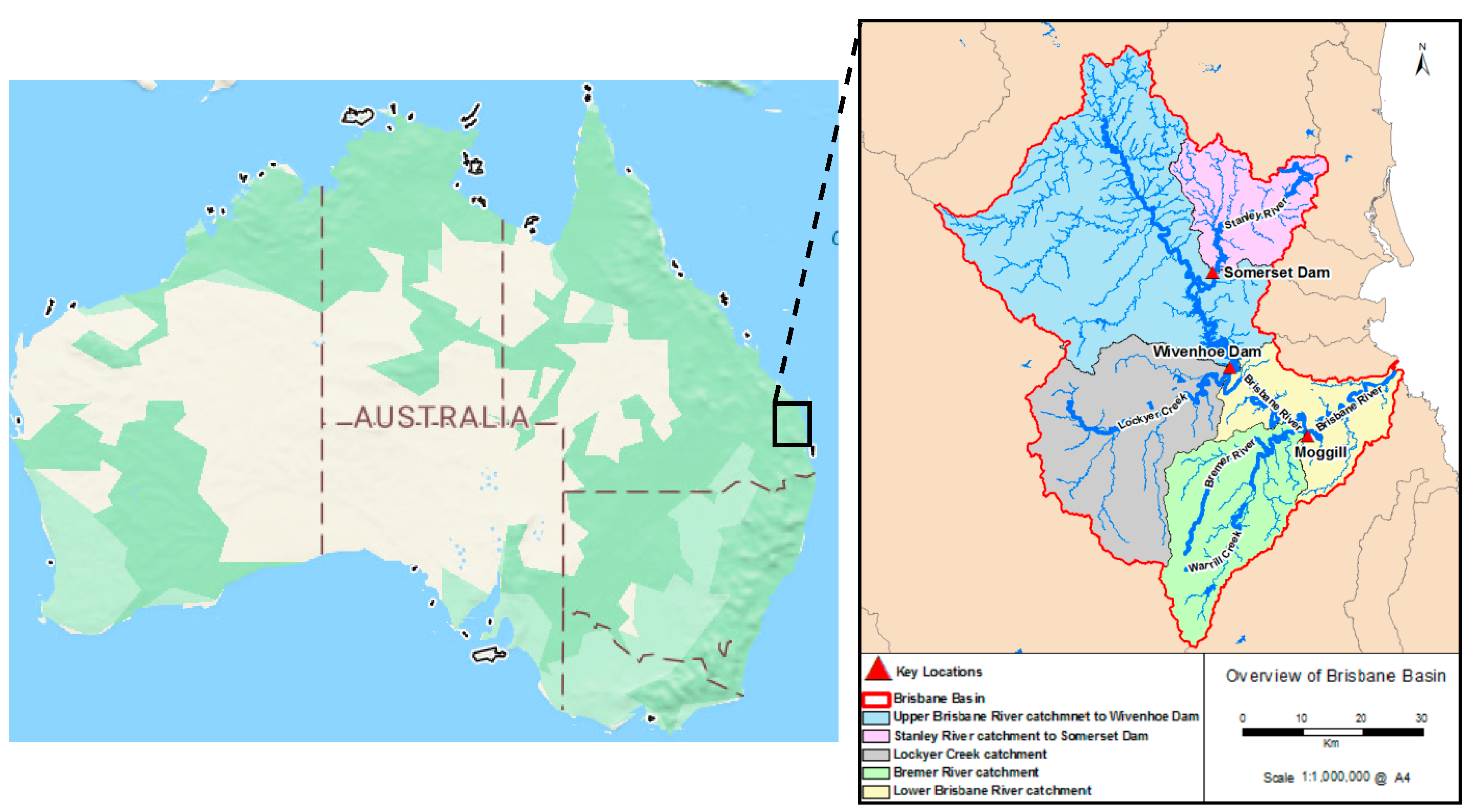
2.1. Wivenhoe Dam: Case Study
2.2. Pre-Feasibility Study for New Dam Development
2.3. Scope of the Work and Study Objectives
2.4. Geospatial Analysis for Supplementary Dam Planning
3. Area Selection for the Supplementary Dam
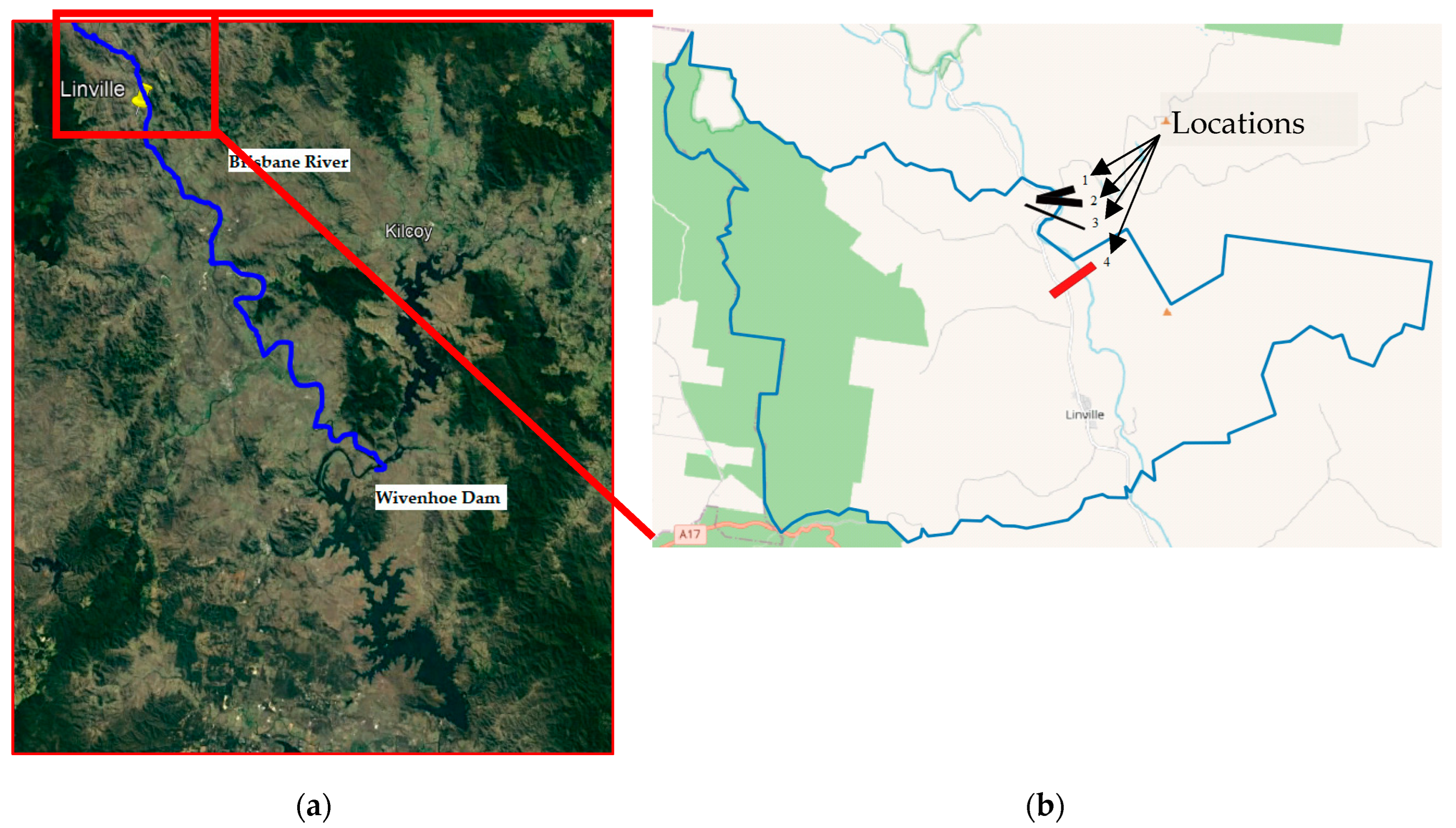
3.1. Study Area Selection
3.2. Linville Catchment
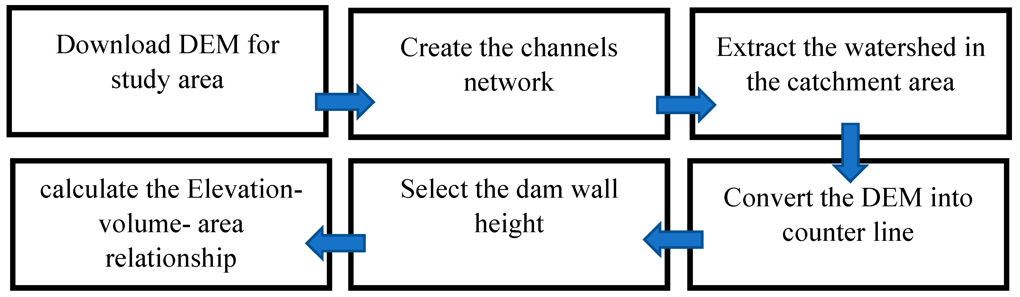
3.3. Geospatial Methodology in Dam Site Determination
4. Results and Discussion
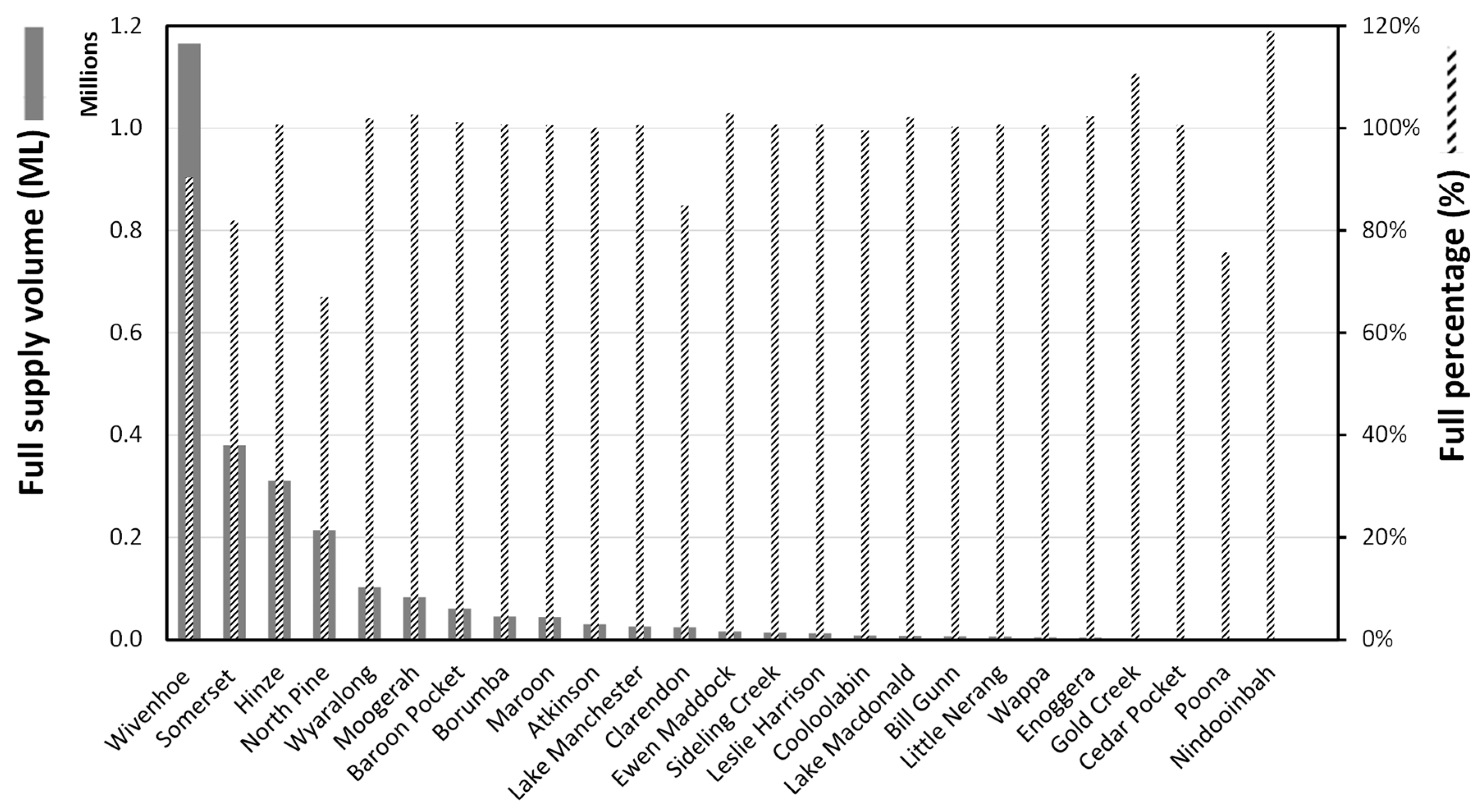
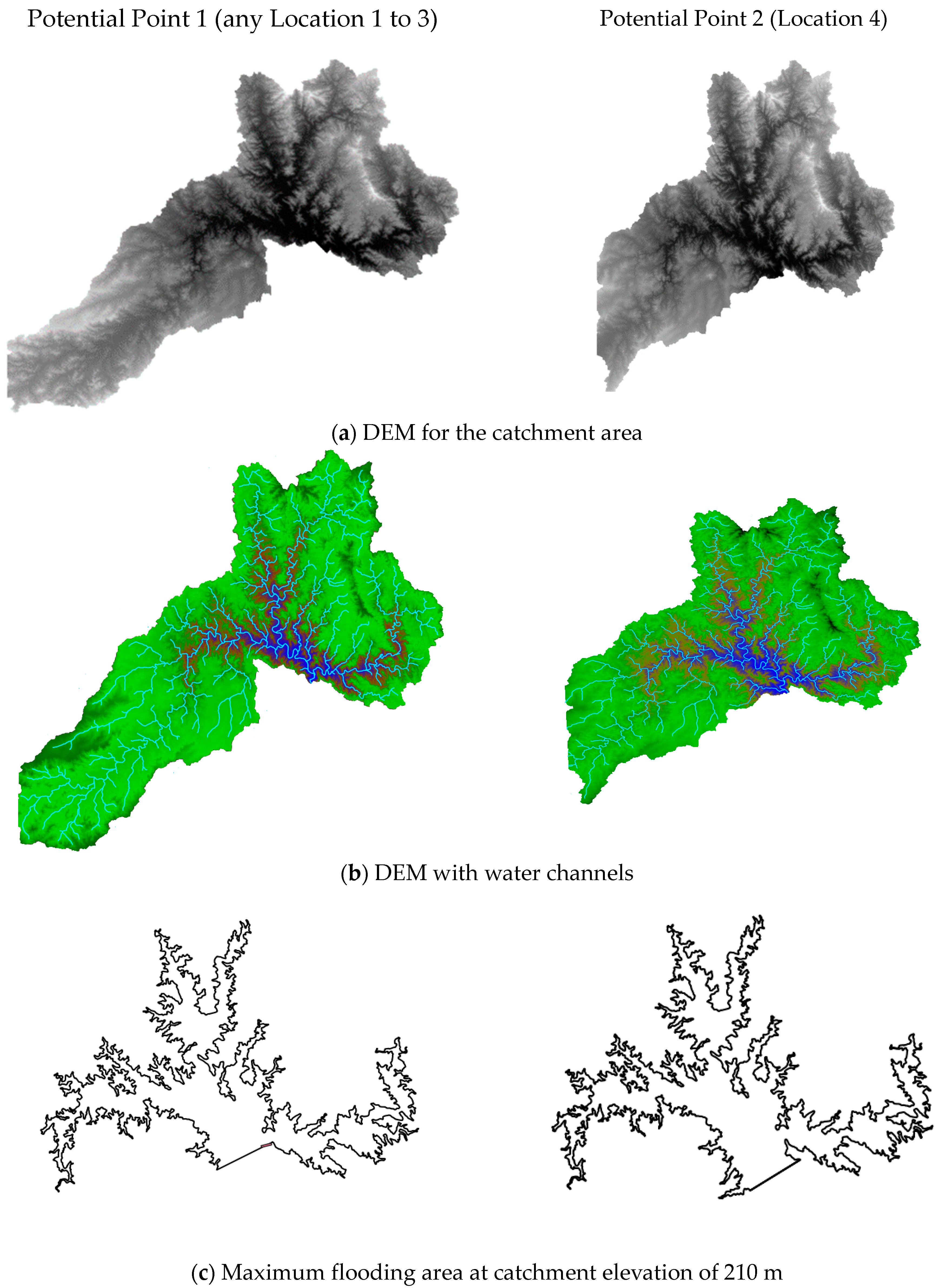
4.1. Catchment Properties at Potential Dam Points
4.2. Topographical Analysis
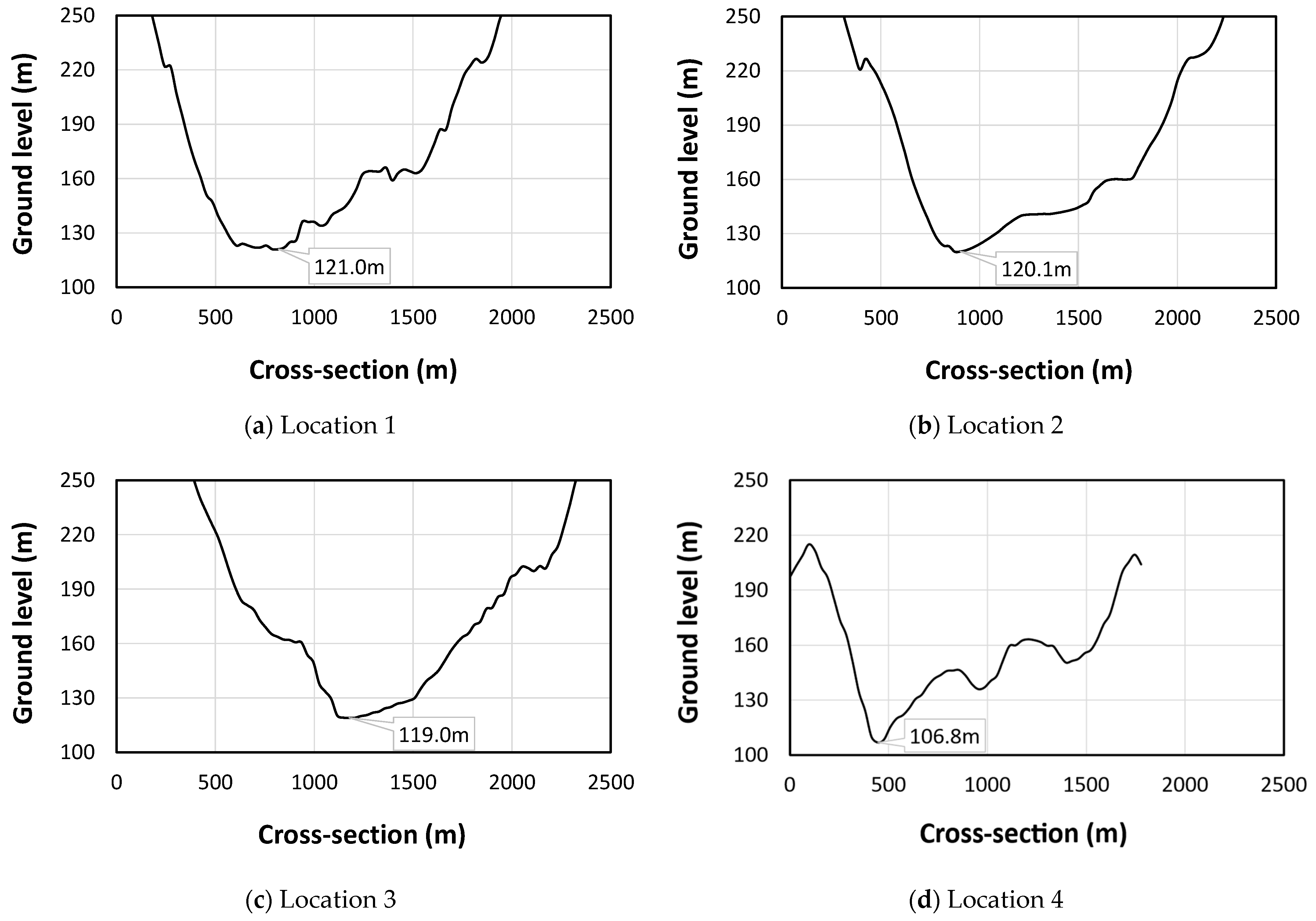
4.2.1. Optimal Dam Wall Location
4.2.2. Optimising the Proposed Dam Wall Dimensions
4.3. Yeild Assessment of the Selected Dam
- For the range of 0.7 to 2.7 m, the discharge ranges from 0.7 to 144 m3/s, with 25 samples. The rating is based on the best fit of both gauging and model data.
- For the range of 2.7 to 7 m, the discharge varies from 144 to 1458 m3/s, with 11 samples. The rating relies on the MIKE 21 model.
- For the range of 7 to 10 m, the discharge spans from 1458 to 3232 m3/s, with 1 sample. The rating is also based on the MIKE 21 model.
5. Conclusions
Author Contributions
Funding
Data Availability Statement
Acknowledgments
Conflicts of Interest
References
- Alley, R.; Berntsen, T.; Bindoff, N.L.; Chen, Z.; Chidthaisong, A.; Friedlingstein, P.; Gregory, J.; Hegerl, G.; Heimann, M.; Hewitson, B. Climate change 2007: The physical science basis. Agenda 2007, 6, 333. [Google Scholar]
- Yoro, K.O.; Daramola, M.O. CO2 emission sources, greenhouse gases, and the global warming effect. In Advances in Carbon Capture; Elsevier: Amsterdam, The Netherlands, 2020; pp. 3–28. [Google Scholar]
- Bureau of Meteorology. State of the Climate 2020; Bureau of Meteorology: Docklands, Austrilia, 2020.
- Lempérière, F.J.E. Dams and floods. Engineering 2017, 3, 144–149. [Google Scholar] [CrossRef]
- Smith, I.; McAlpine, C. Estimating future changes in flood risk: Case study of the Brisbane river, Australia. Clim. Risk Manag. 2014, 6, 6–17. [Google Scholar] [CrossRef]
- QRA. Queensland Flood Risk Management Framework; Queensland Government, Ed.; Queensland Reconstruction Authority: Brisbane City, Austrilia, 2021. [Google Scholar]
- Fedorov, M.; Badenko, V.; Chusov, A.; Maslikov, V. GIS technologies for selecting location of dams in the flood control systems. In E3S Web of Conferences; EDP Sciences: Les Ulis, France, 2019. [Google Scholar]
- Manfreda, S.; Miglino, D.; Albertini, C.J.H.; Sciences, E.S. Impact of detention dams on the probability distribution of floods. Hydrol. Earth Syst. Sci. 2021, 25, 4231–4242. [Google Scholar] [CrossRef]
- BOM. Known Floods in the Brisbane & Bremer River Basin; Australia Bureau of Meteorology: Brisbane City, Austrilia, 2017. [Google Scholar]
- Ajayi, O.G.; Palmer, M.; Salubi, A.A. Modelling farmland topography for suitable site selection of dam construction using unmanned aerial vehicle (UAV) photogrammetry. Remote Sens. Appl. Soc. Environ. 2018, 11, 220–230. [Google Scholar] [CrossRef]
- Sayl, K.N.; Muhammad, N.S.; Yaseen, Z.M.; El-shafie, A. Estimation the physical variables of rainwater harvesting system using integrated GIS-based remote sensing approach. Water Resour. Manag. 2016, 30, 3299–3313. [Google Scholar] [CrossRef]
- Kipkemboi, W.; Kuria, B.T.; Kuria, D.N.; Sichangi, A.W.; Mundia, C.N.; Wanjala, J.A.; Muthee, S.W.; Goebel, M.; Rienow, A. Development of a Web-GIS Platform for Environmental Monitoring and Conservation of the Muringato Catchment in Kenya. J. Geovisualization Spat. Anal. 2023, 7, 13. [Google Scholar] [CrossRef]
- Anna, A.N.; Fikriyah, V.N. Environmental pollution monitoring using a Web-based GIS in Surakarta. In Proceedings of the IOP Conference Series: Earth and Environmental Science, West Sumatra, Indonesia, 15–16 November 2018; IOP Publishing: Bristol, UK, 2018; p. 012066. [Google Scholar]
- Raaj, S.; Pathan, A.I.; Mohseni, U.; Agnihotri, P.G.; Patidar, N.; Islam, M.N.; Patidar, S.; Salihi, M. Dam site suitability analysis using geo-spatial technique and AHP: A case of flood mitigation measures at Lower Tapi Basin. Model. Earth Syst. Environ. 2022, 8, 5207–5223. [Google Scholar] [CrossRef]
- SeqWater. Fact sheet Wivenhoe Dam. Available online: https://www.seqwater.com.au/sites/default/files/2019-09/Fact%20sheet%20-%20About%20Wivenhoe%20Dam.pdf (accessed on 1 September 2019).
- ABC News. State Government Proposes Eight New Dams for South-East Queensland; ABC News: Sydney, Australia, 2014. [Google Scholar]
- QAR. Brisbane River Catchment Flood Studies: A History of living with Flooding. Queensland Reconstruction Authority. 2018. Available online: https://www.qra.qld.gov.au/sites/default/files/2018-11/brisbane_river_catchment_historical_factsheet.pdf (accessed on 1 November 2018).
- ABC News. How Brisbane Is Coping after the February Flood, the City’s Third Major Inundation in 50 Years. ABC News: Sydney, Australia. 2022. Available online: https://www.abc.net.au/news/2022-05-17/the-february-2022-flood-marked-the-third-major/13885832 (accessed on 17 May 2022).
- Shaw, K. Wivenhoe: A Dam Designed to Fail and Decimate Brisbane: With a Solution So That Won’t Happen. Available online: http://www.floodcommission.qld.gov.au/__data/assets/file/0003/8463/Shaw_Ken.pdf (accessed on 4 April 2011).
- ABC News. Wivenhoe Dam $900 Million Safety Revamp Considered to Prevent Brisbane Flood Disaster; ABC News Australia: Sydney, Australia, 2017. [Google Scholar]
- QLD Government. Potential New Dams to Protect Brisbane and Ipswich. Available online: https://statements.qld.gov.au/statements/75474#:~:text=increasing%20the%20flood%20mitigation%20compartment%20of%20Wivenhoe%20Dam,dam%20on%20the%20Lower%20Warrill%20Creek%20near%20Willowbank. (accessed on 29 November 2023).
- SEQWATER. Brisbane River Strategic Floodplain Management Plan. Available online: https://www.qra.qld.gov.au/sites/default/files/2019-04/Plan%20-%20Brisbane%20River%20Strategic%20Floodplain%20Management%20Plan%20%28April%202019%29_2.pdf (accessed on 1 February 2019).
- Petheram, C.; Gallant, J.; Read, A. An automated and rapid method for identifying dam wall locations and estimating reservoir yield over large areas. Environ. Model. Softw. 2017, 92, 189–201. [Google Scholar] [CrossRef]
- Abushandi, E.; Alatawi, S. Dam site selection using remote sensing techniques and geographical information system to control flood events in Tabuk City. Hydrol. Curr. Res. 2015, 6, 1000189. [Google Scholar]
- Al-Ruzouq, R.; Shanableh, A.; Yilmaz, A.G.; Idris, A.; Mukherjee, S.; Khalil, M.A.; Gibril, M.B.A. Dam site suitability mapping and analysis using an integrated GIS and machine learning approach. Water 2019, 11, 1880. [Google Scholar] [CrossRef]
- Sayl, K.N.; Muhammad, N.S.; El-Shafie, A.J.E.E.S. Optimization of area–volume–elevation curve using GIS–SRTM method for rainwater harvesting in arid areas. Environ. Earth Sci. 2017, 76, 1–10. [Google Scholar] [CrossRef]
- Australian Bureau of Statistics. Linville, Census All persons QuickStats. 2021. Available online: https://abs.gov.au/census/find-census-data/quickstats/2021/SAL31666 (accessed on 1 January 2021).
- Department of Environment, Science and Innovation, Queensland. South Eastern Queensland (SEQ) IBRA Bioregion—Facts and Maps, WetlandInfo Website. 2023. Available online: https://wetlandinfo.des.qld.gov.au/wetlands/facts-maps/ibra-bioregion-south-eastern-queensland-seq/ (accessed on 1 January 2023).
- Department of Environment, Science and Innovation. Walking the Landscape—Upper Brisbane Map Journal v1.0 (2020), Presentation. 2020. Available online: https://wetlandinfo.des.qld.gov.au/wetlands/ecology/processes-systems/water/catchment-stories/transcript-upper-brisbane.html (accessed on 1 January 2020).
- Queensland Government. Queensland Spatial Catalogue-QSpatial. 2022. Available online: https://qldspatial.information.qld.gov.au/catalogue/custom/index.page (accessed on 1 January 2022).
- Aurecon Australasia. Brisbane River Catchment Flood Study–Comprehensive Hydrologic AssessmentData, Rating Curve and Historical Flood Review Report. Available online: https://www.qra.qld.gov.au/sites/default/files/2018-12/r.b20702.006.01.mr6_.brcfs_hydraulics_report.draftfinal.pdf (accessed on 1 December 2016).
- Bioregional assessments, Surface water systems. Available online: https://www.bioregionalassessments.gov.au/assessments/11-context-statement-gwydir-subregion/1151-surface-water-systems (accessed on 5 January 2018).


| Potential Point 1 | Potential Point 2 | |
|---|---|---|
| Ground-level elevation (m) | 120.0 ± 1.0 | 106.8 |
| Catchment elevation (m) | 270 | 210 |
| Catchment area (km2) | 1828 | 1586 |
| Maximum flooding area (km2) at 210 | 126.6 | 137.3 |
| Dam wall height (m) | 80.0 ± 1.0 | 93.2 |
| Maximum flooding volume (MML) at 210 m | 3.67 | 4.32 |
| Volume-to-area ratio (MML/km2) | 0.0290 | 0.0315 |
| Wivenhoe Dam | Proposed Dam | Same Watershed Volume | Same Wall Surface Area | Same Cost | |
|---|---|---|---|---|---|
| Catchment area (km2) | 7040 | 1828 | 1828 | 1828 | 1828 |
| Dam wall height (m) | 59 | 110 | 85 | 93 | 73 |
| Dam wall length (m) | 2300 | 1630 | 1360 | 1460 | 1330 |
| Dam side area (m2) | 135,700 | 179,300 | 114,750 | 135,700 | 97,090 |
| Watershed area (km2) | 110 | 137.3 | 106 | 131 | 82 |
| Watershed volume (MML) | 3.132 | 6.383 | 3.132 | 3.750 | 2.230 |
| Volume-to-area ratio (MML/km2) | 0.0282 | 0.0465 | 0.0295 | 0.0286 | 0.0272 |
| Dam wall construction cost (AUD M) | 272.1 | 584.8 | 347.6 | 420.0 | 272.1 |
| Volume-to-cost ratio (L/AUD) | 11510 | 10915 | 9010 | 8929 | 8196 |
| Option 1 | Option 2 | Option 3 | Option 4 | |
|---|---|---|---|---|
| Watershed volume | √√ | √ | √ | × |
| Water harvesting efficiency | √√ | √ | √ | √ |
| Dam wall construction cost efficiency | √ | √ | √ | √ |
Disclaimer/Publisher’s Note: The statements, opinions and data contained in all publications are solely those of the individual author(s) and contributor(s) and not of MDPI and/or the editor(s). MDPI and/or the editor(s) disclaim responsibility for any injury to people or property resulting from any ideas, methods, instructions or products referred to in the content. |
© 2024 by the authors. Licensee MDPI, Basel, Switzerland. This article is an open access article distributed under the terms and conditions of the Creative Commons Attribution (CC BY) license (https://creativecommons.org/licenses/by/4.0/).
Share and Cite
Zytoon, A.; Gharineiat, Z.; Alajarmeh, O. Supplementary Dam Site Selection Using a Geospatial Approach: A Case Study of Wivenhoe Dam. ISPRS Int. J. Geo-Inf. 2024, 13, 180. https://doi.org/10.3390/ijgi13060180
Zytoon A, Gharineiat Z, Alajarmeh O. Supplementary Dam Site Selection Using a Geospatial Approach: A Case Study of Wivenhoe Dam. ISPRS International Journal of Geo-Information. 2024; 13(6):180. https://doi.org/10.3390/ijgi13060180
Chicago/Turabian StyleZytoon, Aseel, Zahra Gharineiat, and Omar Alajarmeh. 2024. "Supplementary Dam Site Selection Using a Geospatial Approach: A Case Study of Wivenhoe Dam" ISPRS International Journal of Geo-Information 13, no. 6: 180. https://doi.org/10.3390/ijgi13060180
APA StyleZytoon, A., Gharineiat, Z., & Alajarmeh, O. (2024). Supplementary Dam Site Selection Using a Geospatial Approach: A Case Study of Wivenhoe Dam. ISPRS International Journal of Geo-Information, 13(6), 180. https://doi.org/10.3390/ijgi13060180