

Cartography and Neural Networks: A Scientometric Analysis Based on CiteSpace
 , ,
, ,
Abstract
1. Introduction
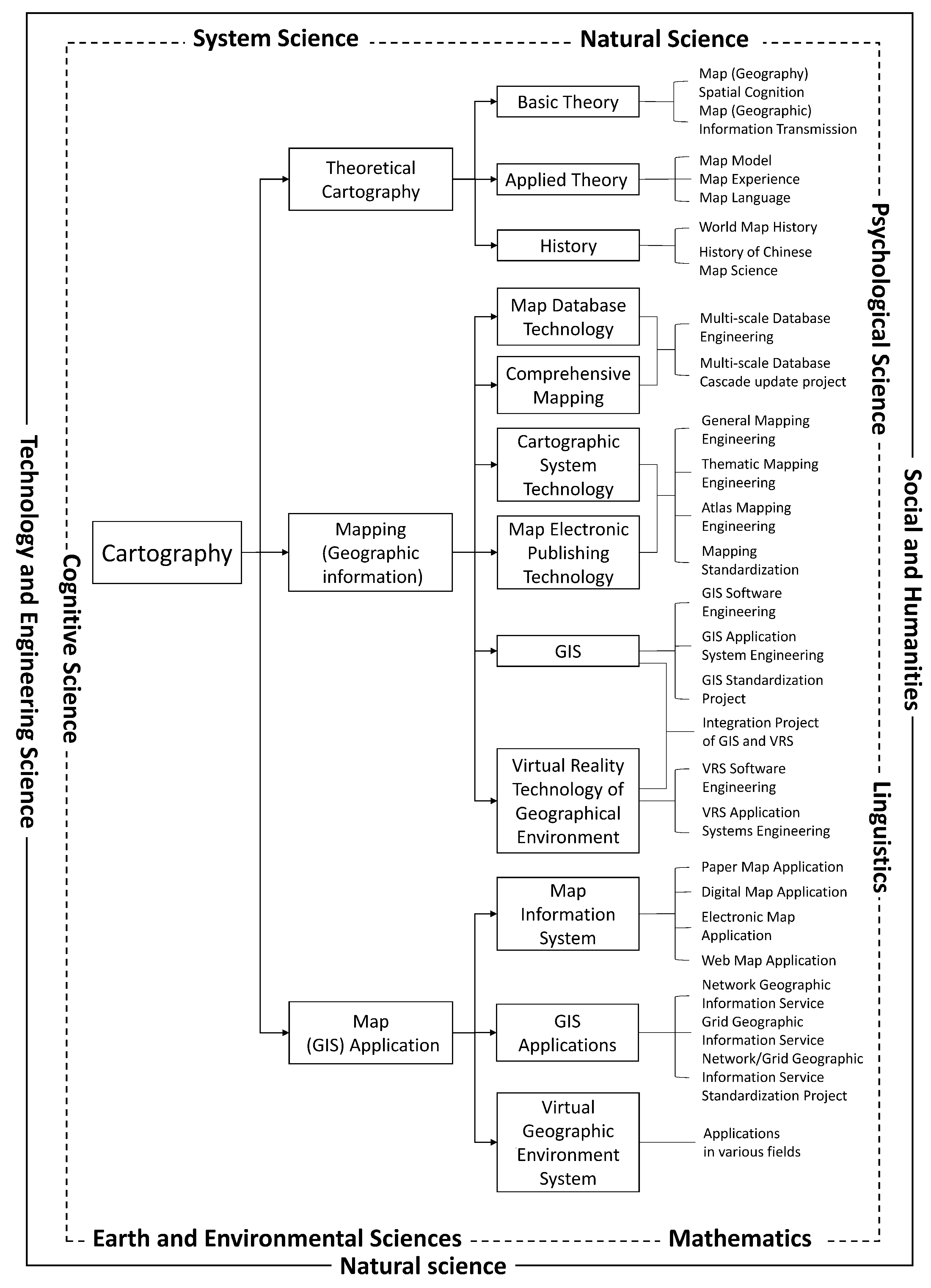
1.1. Cartography and Neural Networks
1.2. Importance of Reviewing and Evaluating Previous Work
1.3. Knowledge Mapping and CiteSpace
1.4. Paper Structure
2. Method
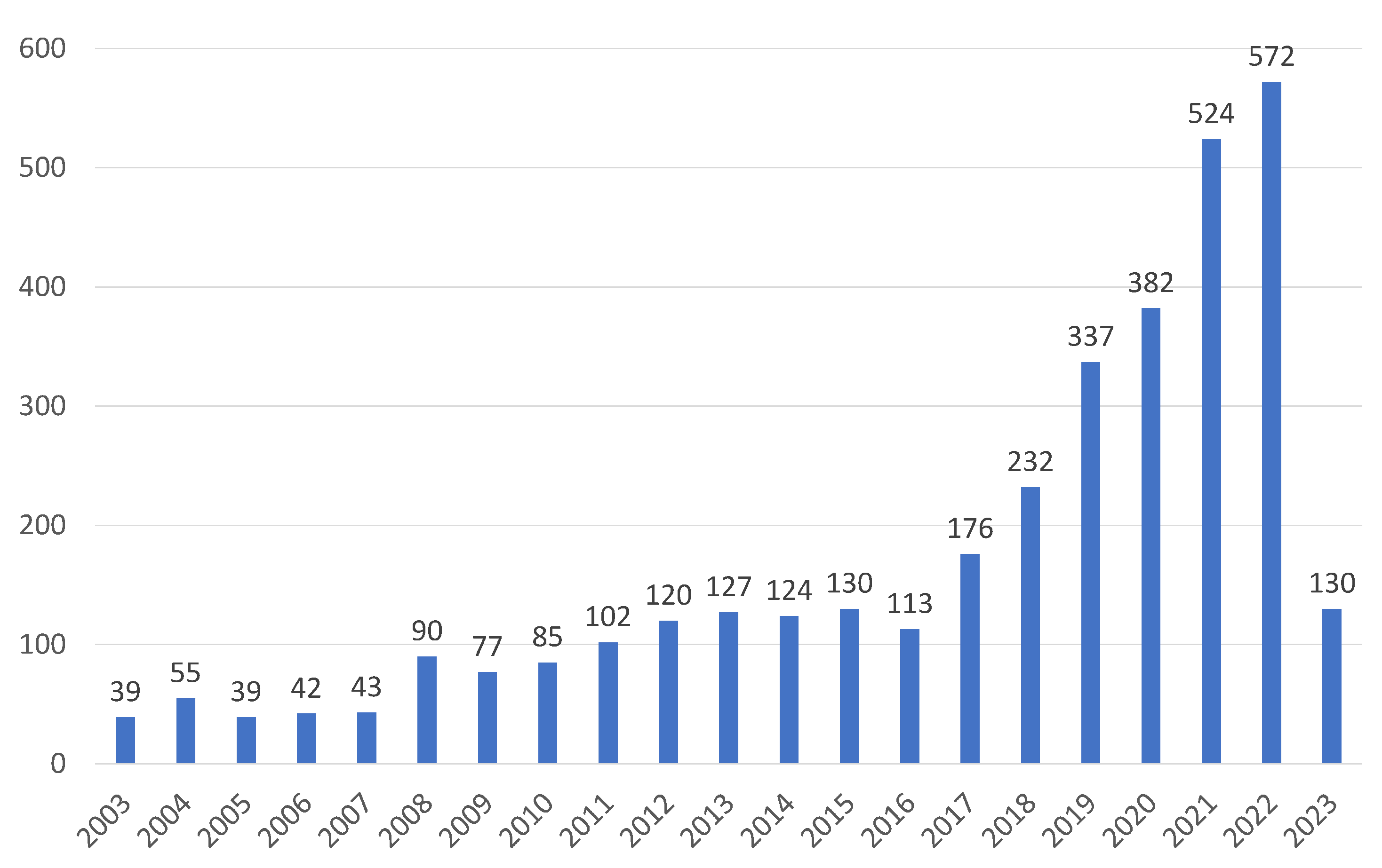
2.1. Data Collection
2.2. Visualization and Analysis
3. Results
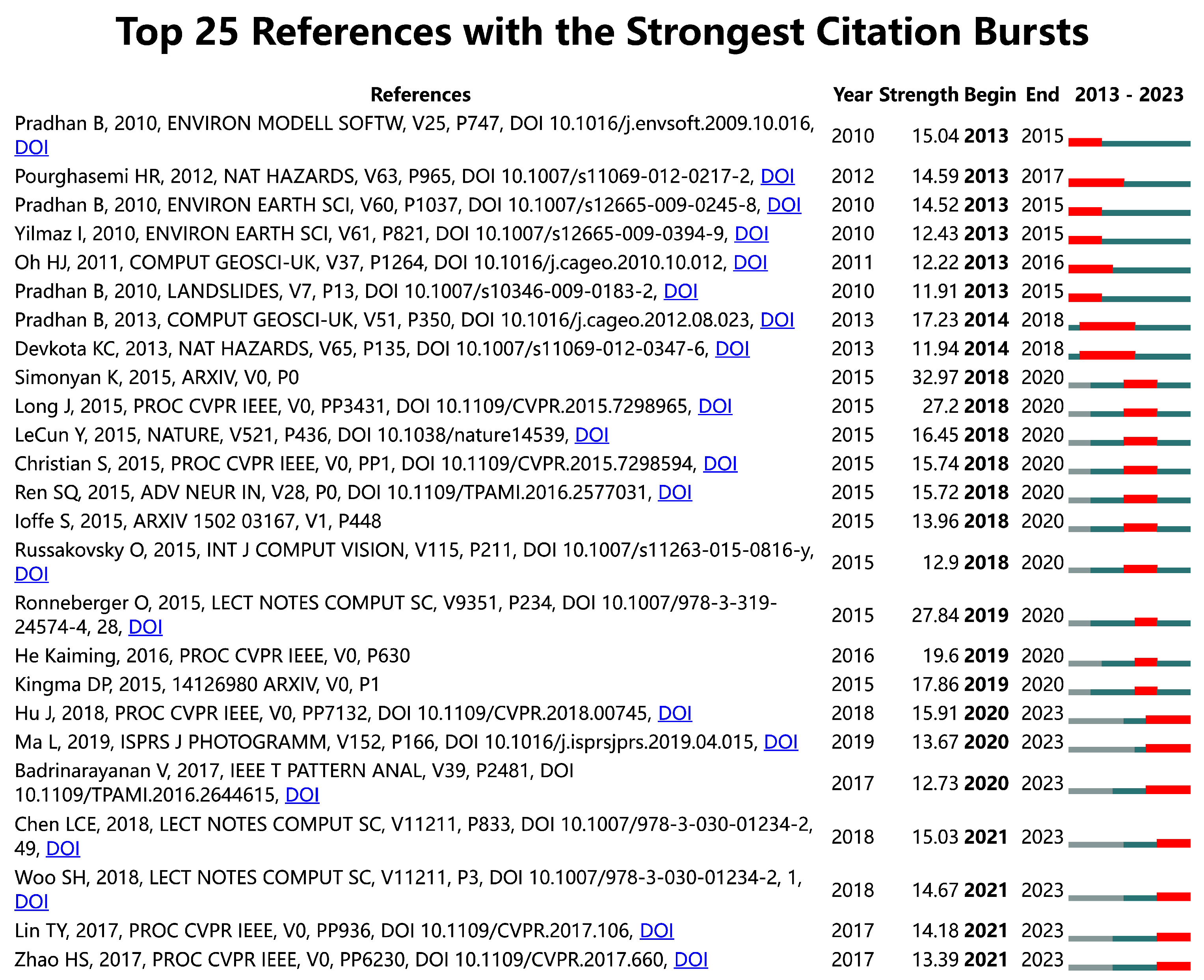
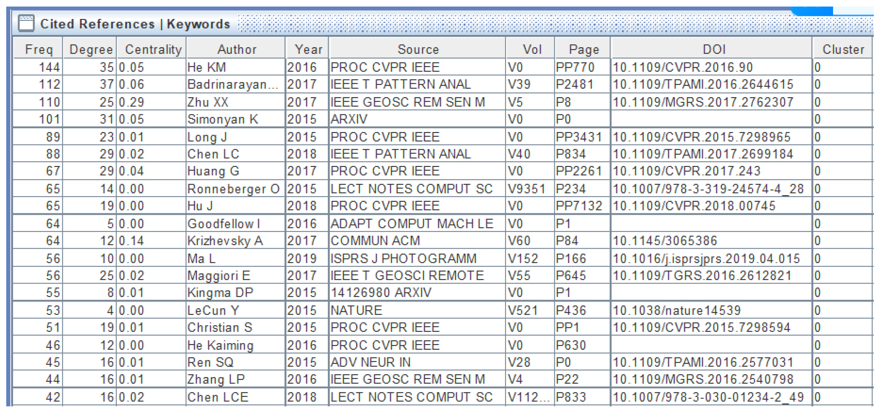
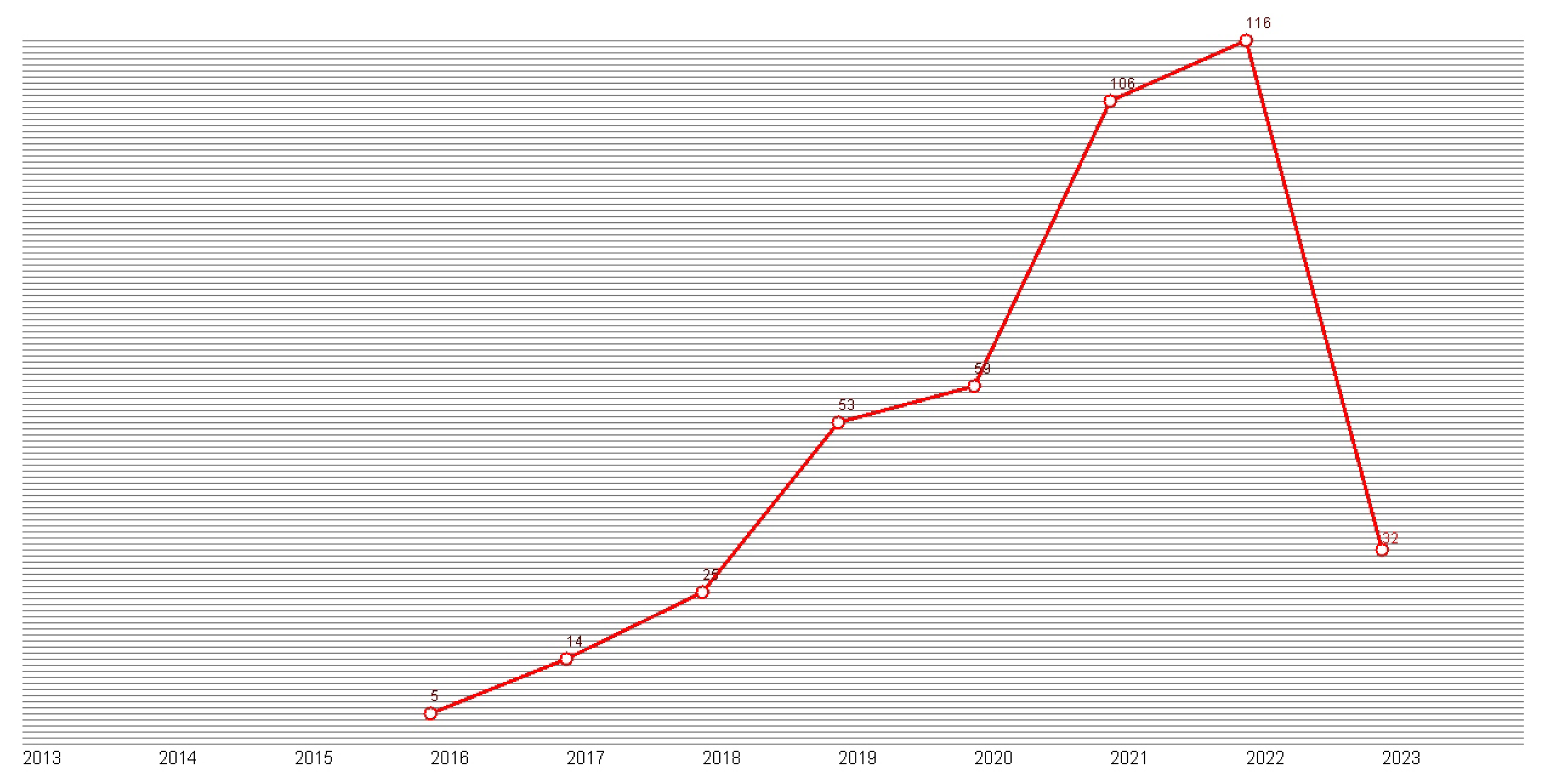
3.1. Key Publications
3.2. Major Research Theme
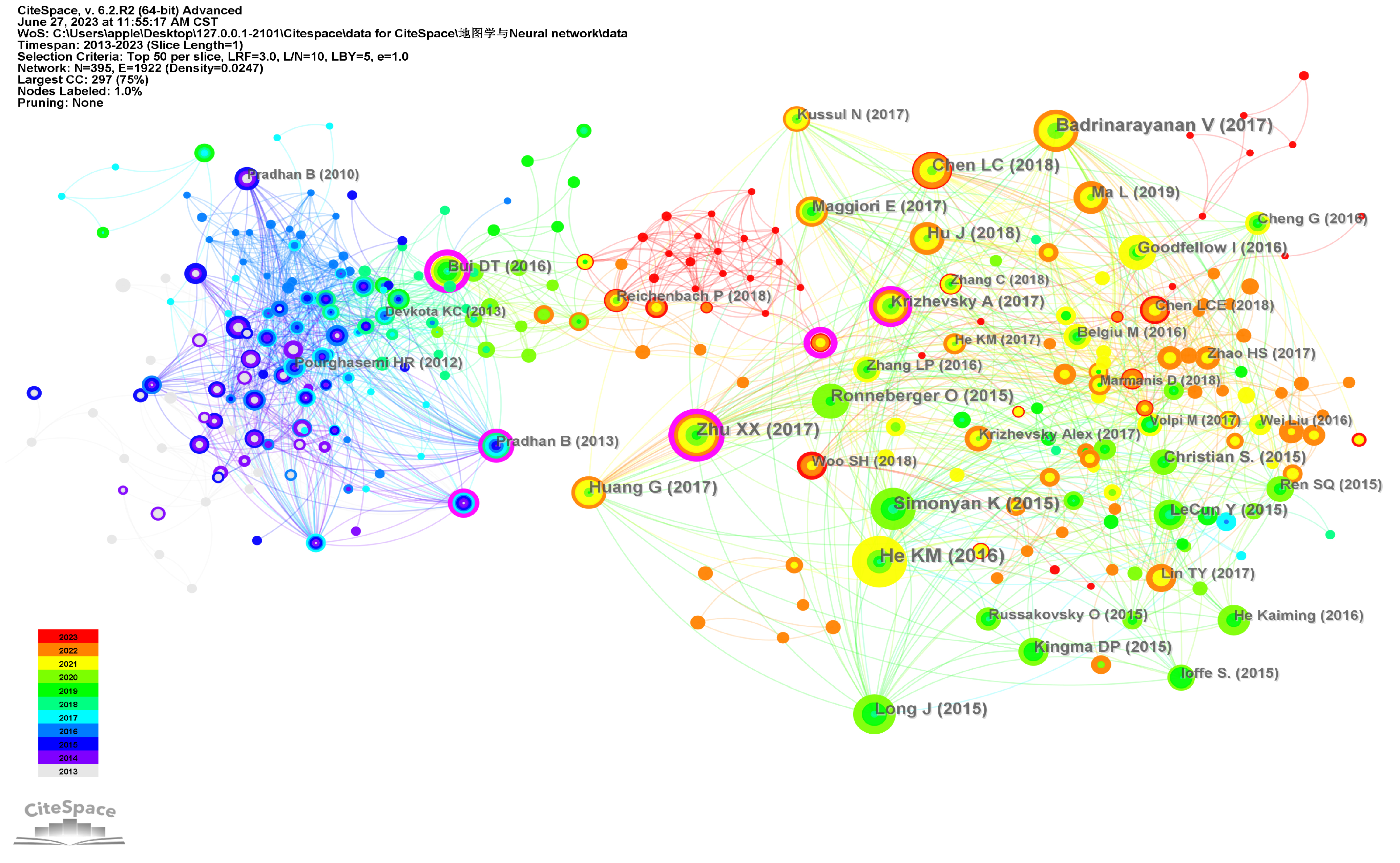
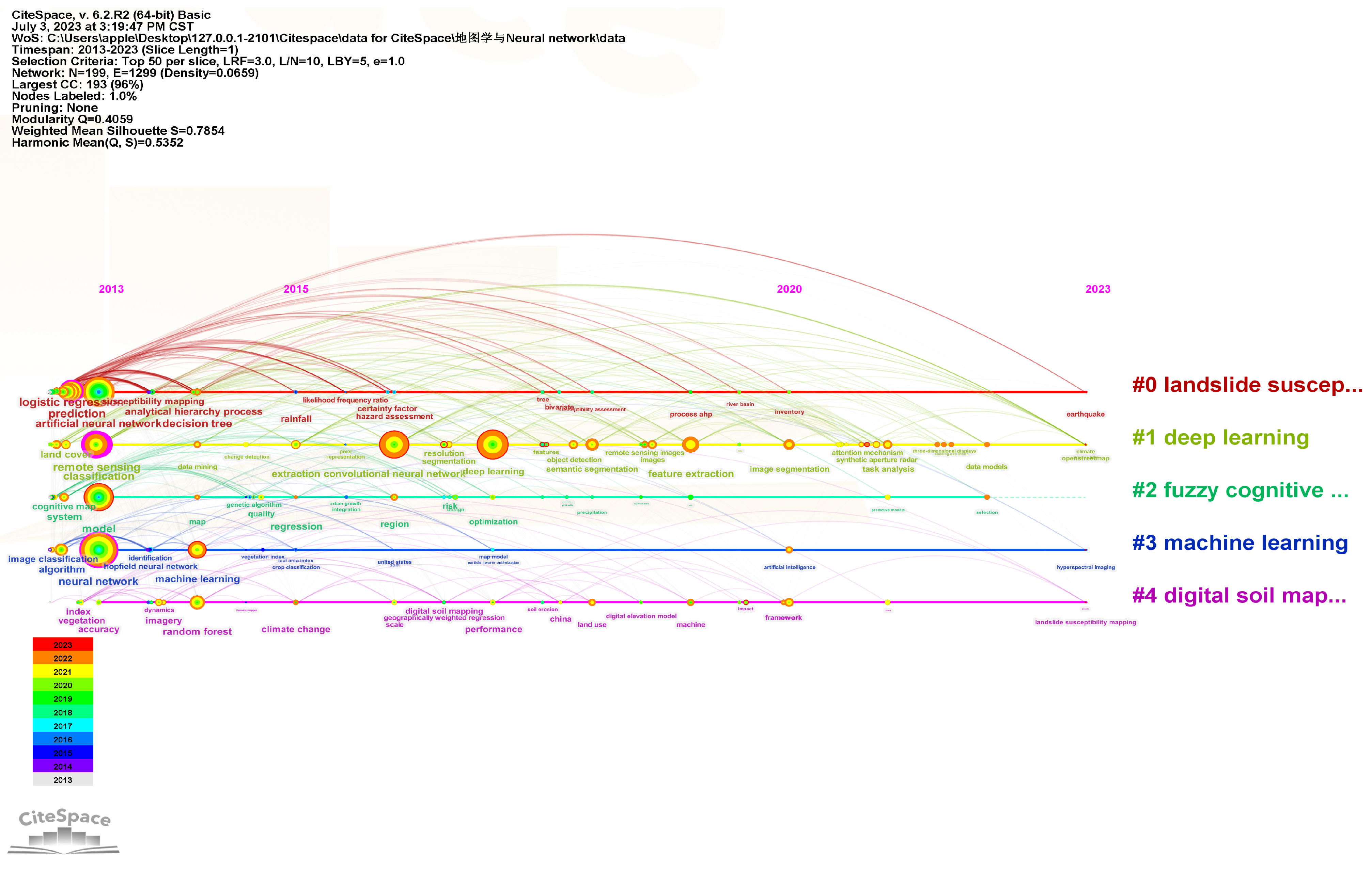
3.2.1. Temporal Analysis
3.2.2. Cluster #0—Landslide Susceptibility Mapping
3.2.3. Cluster #1 and #3—Deep Learning and Machine Learning
3.2.4. Cluster #2—Fuzzy Cognitive Map
3.2.5. Cluster #4—Digital Soil Mapping
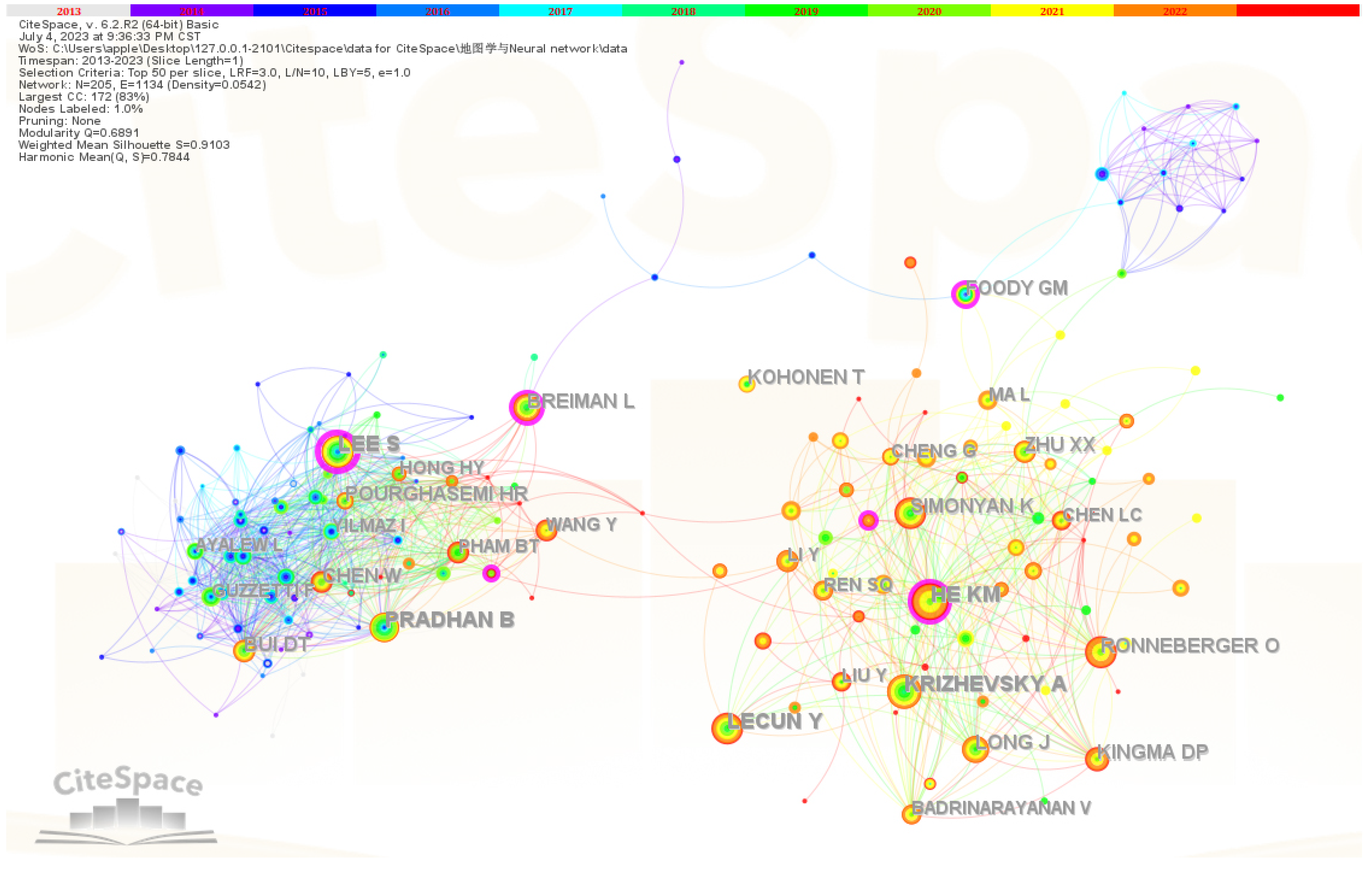
3.3. Core Scholars
3.4. Core Journals
3.5. Collaboration among Institutions
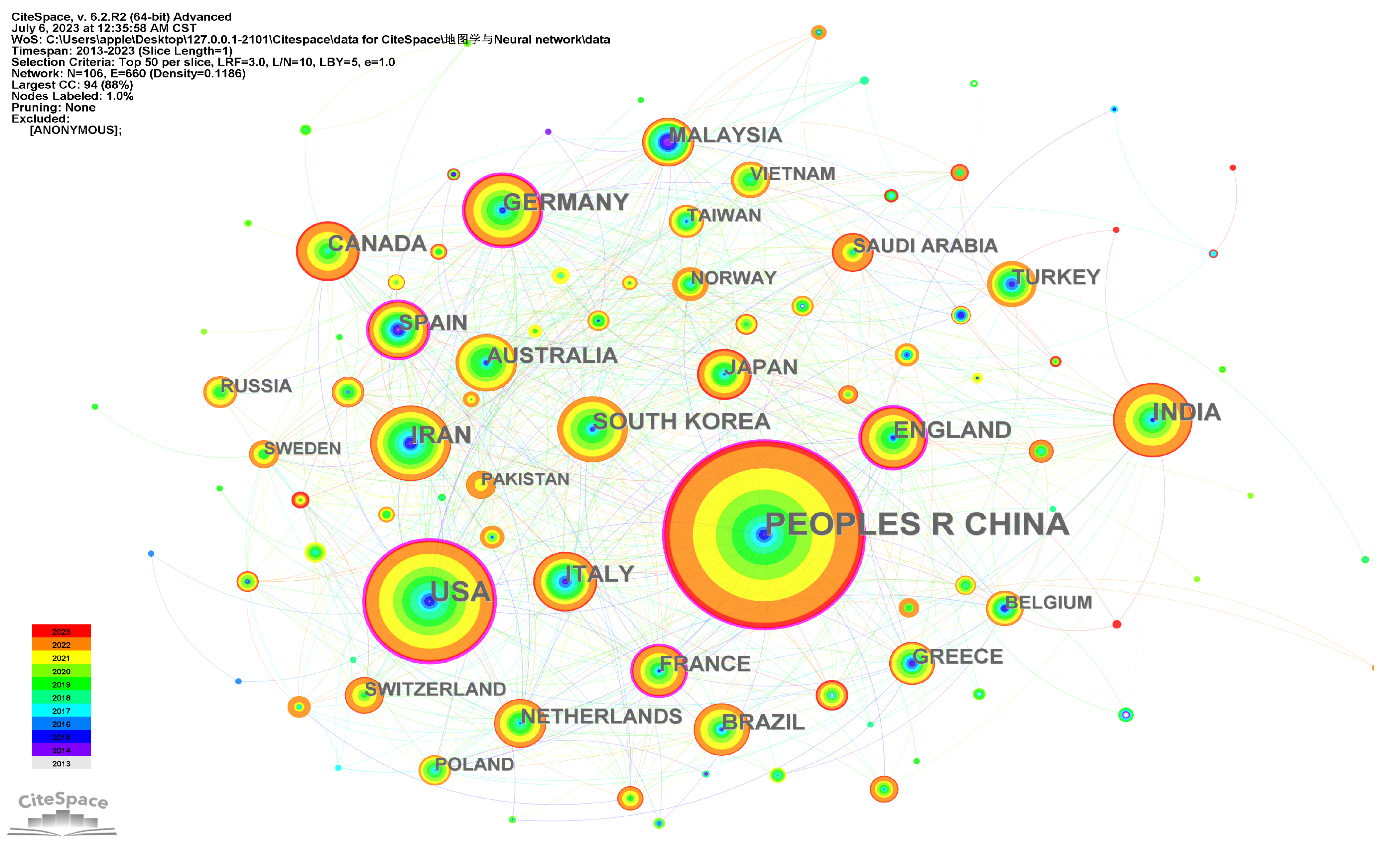
3.6. Distribution of Countries
4. Limitations
5. Conclusions
Author Contributions
Funding
Institutional Review Board Statement
Informed Consent Statement
Data Availability Statement
Acknowledgments
Conflicts of Interest
Abbreviations
| GIS | Geographic Information System |
| SCI-EXPANDED | Science Citation Index Expanded |
| SSCI | Social Sciences Citation Index |
| AHCI | Arts & Humanities Citation Index |
| ESCI | Emerging Sources Citation Index |
| CPCI-S | Conference Proceedings Citation Index—Science |
| CPCI-SSH | Conference Proceedings Citation Index—Social Science & Humanities |
| ANN | Artificial Neural Network |
| CNN | Convolutional Neural Network |
| SVM | Support Vector Machine |
| LLR | Log-Likelihood Ratio |
| LSP | Landslide Susceptibility Prediction |
| MCDA | Multi-Criteria Decision Analysis |
| SVR | Support Vector Regression |
| BLR | Binary Logistic Regression |
| DT | Decision Tree |
| MLP | Multilayer Perceptron Neural Network |
| FCM | Fuzzy cognitive map |
| ISEMK | Intelligent Expert System based on Cognitive Maps |
| ML | Machine Learning |
| RK | Regression Kriging |
| MLR | Multiple Linear Regression |
| RF | Random forest |
| NN | Neural Network |
| BRT | Boosted Regression Tree |
| GWR | Geographically Weighted Regression |
| CART | Classification and Regression Tree |
| ACE | Alternating Conditional Expectation |
| CNRS | Centre National de la Recherche Scientifique |
References
- Tinghua, A. Some thoughts on deep learning enabling cartography. Acta Geod. Et Cartogr. Sin. 2021, 50, 1170. [Google Scholar]
- Jiayao, W. Cartography in the age of spatio-temporal big data. Acta Geod. Et Cartogr. Sin. 2017, 46, 1226. [Google Scholar]
- Konečný, M.; Cartwright, W. International Cartographic Association. In Joint Board of Geospatial Information Societies (JB GIS); United Nations Office for Outer Space Affairs (UNOOSA): Vienna, Austria, 2010. [Google Scholar]
- Zhong, E. Deep Mapping—A Critical Engagement of Cartography with Neuroscience. Geomat. Inf. Sci. Wuhan Univ. 2022, 47, 1988–2002. [Google Scholar]
- Bertin, J. Semiology of graphics: Diagrams, Networks, Maps. Ann. Assoc. Am. Geogr. 1983, 10, 10438353. [Google Scholar]
- Jiayao, W.; Fang, W.; Haowen, Y. Cartography: Its past, present and future. Acta Geod. Et Cartogr. Sin. 2022, 51, 829. [Google Scholar]
- Janowicz, K.; Gao, S.; McKenzie, G.; Hu, Y.; Bhaduri, B. GeoAI: Spatially explicit artificial intelligence techniques for geographic knowledge discovery and beyond. Int. J. Geogr. Inf. Sci. 2020, 34, 625–636. [Google Scholar] [CrossRef]
- Reichstein, M.; Camps-Valls, G.; Stevens, B.; Jung, M.; Denzler, J.; Carvalhais, N.; Prabhat, F. Deep learning and process understanding for data-driven Earth system science. Nature 2019, 566, 195–204. [Google Scholar] [CrossRef] [PubMed]
- Webster, J.; Watson, R.T. Analyzing the past to prepare for the future: Writing a literature review. Mis Q. 2002, 26, xiii–xxiii. [Google Scholar]
- Hart, C. Doing a Literature Review: Releasing the Research Imagination; Sage Publications Ltd.: Thousand Oaks, CA, USA, 2018; 352p. [Google Scholar]
- Li, X.; Ma, E.; Qu, H. Knowledge mapping of hospitality research- A visual analysis using CiteSpace. Int. J. Hosp. Manag. 2017, 60, 77–93. [Google Scholar] [CrossRef]
- Ma, J.; Law, R. Components of tourism research: Evidence from annals of tourism research. Anatolia 2009, 20, 62–74. [Google Scholar] [CrossRef]
- Crawford-Welch, S.; McCleary, K.W. An identification of the subject areas and research techniques used in five hospitality-related journals. Int. J. Hosp. Manag. 1992, 11, 155–167. [Google Scholar] [CrossRef]
- Yan, W.; Zhongxiang, C.; Shulei, Z.; Hongjian, L.; Linxiang, Z.; Ziyi, L. Visualized analysis of cartography research status. Geospat. Inf. 2018, 16, 5. [Google Scholar]
- Clarke, K.C.; Johnson, J.M.; Trainor, T. Contemporary American cartographic research: A review and prospective. Cartogr. Geogr. Inf. Sci. 2019, 46, 196–209. [Google Scholar] [CrossRef]
- Griffin, A.L.; Robinson, A.C.; Roth, R.E. Envisioning the future of cartographic research. Int. J. Cartogr. 2017, 3, 1–8. [Google Scholar] [CrossRef]
- Shi, H.; Jie, Y. Cognitive map research in the field of geography: A review and prospect. Prog. Geogr. 2022, 41, 13. [Google Scholar]
- Guangying, W.; Tinghua, A.; Lina, H.; Xiaoyu, B.; Leyi, F. Research progress analysis of map dynamic visualization based on bibliometrics. Sci. Surv. Mapp. 2021, 46, 10. [Google Scholar]
- Leng, S.; Gao, X.; Pei, T.; Zhang, G.; Chen, L.; Chen, X.; He, C.; He, D.; Li, X.; Lin, C.; et al. The Geographical Sciences during 1986—2015: From the Classics to the Frontiers; Springer: Berlin/Heidelberg, Germany, 2016. [Google Scholar]
- Bottini, R.; Doeller, C.F. Knowledge across reference frames: Cognitive maps and image spaces. Trends Cogn. Sci. 2020, 24, 606–619. [Google Scholar] [CrossRef] [PubMed]
- Musa, A.; Khan, S.; Mujahid, M.; El-Gaby, M. The shallow cognitive map hypothesis: A hippocampal framework for thought disorder in schizophrenia. Schizophrenia 2022, 8, 34. [Google Scholar] [CrossRef]
- Grossberg, S. Developmental designs and adult functions of cortical maps in multiple modalities: Perception, attention, navigation, numbers, streaming, speech, and cognition. Front. Neuroinform. 2020, 14, 4. [Google Scholar] [CrossRef]
- Bermudez-Contreras, E.; Clark, B.J.; Wilber, A. The neuroscience of spatial navigation and the relationship to artificial intelligence. Front. Comput. Neurosci. 2020, 14, 63. [Google Scholar] [CrossRef]
- Xu, Y.; Zhu, H.; Hu, C.; Liu, H.; Cheng, Y. Deep learning of DEM image texture for landform classification in the Shandong area, China. Front. Earth Sci. 2022, 16, 352–367. [Google Scholar] [CrossRef]
- Abdollahi, A.; Pradhan, B.; Shukla, N.; Chakraborty, S.; Alamri, A. Deep learning approaches applied to remote sensing datasets for road extraction: A state-of-the-art review. Remote Sens. 2020, 12, 1444. [Google Scholar] [CrossRef]
- Javan, F.D.; Samadzadegan, F.; Mehravar, S.; Toosi, A.; Khatami, R.; Stein, A. A review of image fusion techniques for pan-sharpening of high-resolution satellite imagery. ISPRS J. Photogramm. Remote Sens. 2021, 171, 101–117. [Google Scholar] [CrossRef]
- Pashaei, M.; Kamangir, H.; Starek, M.J.; Tissot, P. Review and evaluation of deep learning architectures for efficient land cover mapping with UAS hyper-spatial imagery: A case study over a wetland. Remote Sens. 2020, 12, 959. [Google Scholar] [CrossRef]
- Talukdar, S.; Singha, P.; Mahato, S.; Pal, S.; Liou, Y.A.; Rahman, A. Land-use land-cover classification by machine learning classifiers for satellite observations—A review. Remote Sens. 2020, 12, 1135. [Google Scholar] [CrossRef]
- Ma, L.; Liu, Y.; Zhang, X.; Ye, Y.; Yin, G.; Johnson, B.A. Deep learning in remote sensing applications: A meta-analysis and review. ISPRS J. Photogramm. Remote Sens. 2019, 152, 166–177. [Google Scholar] [CrossRef]
- Matin, S.S.; Pradhan, B. Challenges and limitations of earthquake-induced building damage mapping techniques using remote sensing images-A systematic review. Geocarto Int. 2022, 37, 6186–6212. [Google Scholar] [CrossRef]
- Kuras, A.; Brell, M.; Rizzi, J.; Burud, I. Hyperspectral and lidar data applied to the urban land cover machine learning and neural-network-based classification: A review. Remote Sens. 2021, 13, 3393. [Google Scholar] [CrossRef]
- Speel, P.H.; Shadbolt, N.; Vries, W.D.; Dam, P.H.V.; O’Hara, K. Knowledge Mapping for Industrial Purposes. 1999. Available online: https://api.semanticscholar.org/CorpusID:106808042 (accessed on 27 May 2024).
- Chen, C. CiteSpace II: Detecting and visualizing emerging trends and transient patterns in scientific literature. J. Am. Soc. Inf. Sci. Technol. 2006, 57, 359–377. [Google Scholar] [CrossRef]
- Chen, C.; Ibekwe-SanJuan, F.; Hou, J. The structure and dynamics of cocitation clusters: A multiple-perspective cocitation analysis. J. Am. Soc. Inf. Sci. Technol. 2010, 61, 1386–1409. [Google Scholar] [CrossRef]
- Chen, C.; Dubin, R.; Kim, M.C. Emerging trends and new developments in regenerative medicine: A scientometric update (2000–2014). Expert Opin. Biol. Ther. 2014, 14, 1295–1317. [Google Scholar] [CrossRef] [PubMed]
- Cui, X.P.M.; Yu, X.; Hua, W. How is CiteSpace Used and Cited in the Literature? An Analysis of the Articles Published in English and Chinese Core Journals; International Conference on Scientometrics and Informetrics: Wuhan, China, 2017. [Google Scholar]
- Cobo, M.J.; López-Herrera, A.G.; Herrera-Viedma, E.; Herrera, F. Science mapping software tools: Review, analysis, and cooperative study among tools. J. Am. Soc. Inf. Sci. Technol. 2011, 62, 1382–1402. [Google Scholar] [CrossRef]
- Chen, C. Science mapping: A systematic review of the literature. J. Data Inf. Sci. 2017, 2, 1–40. [Google Scholar] [CrossRef]
- Wei, F.; Grubesic, T.H.; Bishop, B.W. Exploring the GIS knowledge domain using CiteSpace. Prof. Geogr. 2015, 67, 374–384. [Google Scholar] [CrossRef]
- Grubesic, T.H.; Matisziw, T.C.; Murray, A.T.; Snediker, D. Comparative approaches for assessing network vulnerability. Int. Reg. Sci. Rev. 2008, 31, 88–112. [Google Scholar] [CrossRef]
- Wang, J.; Sun, Q.; Wang, G.; Jiang, N.; Li, X. Principles and Methods of Cartography; Science Press: Beijing, China, 2006. [Google Scholar]
- Wang, J.; Sun, Q.; Wang, G.; Jiang, N.; Li, X. Principles and Methods of Cartography-2; Science Press: Beijing, China, 2014. [Google Scholar]
- Liqiu, M. The constancy and volatility in cartography. Acta Geod. Et Cartogr. Sin. 2017, 46, 1637. [Google Scholar]
- Dong, W.; Zheng, L.; Liu, B.; Meng, L. Using eye tracking to explore differences in map-based spatial ability between geographers and non-geographers. ISPRS Int. J. Geo-Inf. 2018, 7, 337. [Google Scholar] [CrossRef]
- Wang, Y.; Wang, R.; Zhu, Y. Optimal path-finding through mental exploration based on neural energy field gradients. Cogn. Neurodynamics 2017, 11, 99–111. [Google Scholar] [CrossRef]
- Qin, F.; Zhu, Y.; Ao, T.; Chen, T. The development trend and research frontiers of distributed hydrological models—Visual bibliometric analysis based on citespace. Water 2021, 13, 174. [Google Scholar] [CrossRef]
- Rong, W.; Haowem, Y.; Zhonghui, W. Hotspots and trends visual analysis of Contour automated generalization. Sci. Surv. Mapp. 2021, 46, 167–176+193. [Google Scholar]
- Jaderberg, M.; Simonyan, K.; Zisserman, A.; Kavukcuoglu, K. Spatial transformer networks. Adv. Neural Inf. Process. Syst. 2015, 28. Available online: https://api.semanticscholar.org/CorpusID:6099034 (accessed on 27 May 2024).
- Wang, C.; Xu, R.; Xu, S.; Meng, W.; Wang, R.; Zhang, J.; Zhang, X. Towards accurate and efficient road extraction by leveraging the characteristics of road shapes. IEEE Trans. Geosci. Remote. Sens. 2023, 61, 4404616. [Google Scholar] [CrossRef]
- Long, J.; Shelhamer, E.; Darrell, T. Fully convolutional networks for semantic segmentation. In Proceedings of the IEEE Conference on Computer Vision and Pattern Recognition, Boston, MA, USA, 7–12 June 2015; pp. 3431–3440. [Google Scholar]
- He, K.; Zhang, X.; Ren, S.; Sun, J. Deep residual learning for image recognition. In Proceedings of the IEEE Conference on Computer Vision and Pattern Recognition, Las Vegas, NV, USA, 26 June–1 July 2016; pp. 770–778. [Google Scholar]
- LeCun, Y.; Bengio, Y.; Hinton, G. Deep learning. Nature 2015, 521, 436–444. [Google Scholar] [CrossRef] [PubMed]
- Pradhan, B.; Lee, S. Landslide susceptibility assessment and factor effect analysis: Backpropagation artificial neural networks and their comparison with frequency ratio and bivariate logistic regression modelling. Environ. Model. Softw. 2010, 25, 747–759. [Google Scholar] [CrossRef]
- Pradhan, B. A comparative study on the predictive ability of the decision tree, support vector machine and neuro-fuzzy models in landslide susceptibility mapping using GIS. Comput. Geosci. 2013, 51, 350–365. [Google Scholar] [CrossRef]
- Hu, J.; Shen, L.; Sun, G. Squeeze-and-excitation networks. In Proceedings of the IEEE Conference on Computer Vision and Pattern Recognition, Salt Lake, UT, USA, 18–23 June 2018; pp. 7132–7141. [Google Scholar]
- Badrinarayanan, V.; Kendall, A.; Cipolla, R. Segnet: A deep convolutional encoder-decoder architecture for image segmentation. IEEE Trans. Pattern Anal. Mach. Intell. 2017, 39, 2481–2495. [Google Scholar] [CrossRef] [PubMed]
- Chen, L.C.; Zhu, Y.; Papandreou, G.; Schroff, F.; Adam, H. Encoder-decoder with atrous separable convolution for semantic image segmentation. In Proceedings of the European Conference on Computer Vision (ECCV), Munich, Germany, 8–14 September 2018; pp. 801–818. [Google Scholar]
- Woo, S.; Park, J.; Lee, J.Y.; Kweon, I.S. Cbam: Convolutional block attention module. In Proceedings of the European Conference on Computer Vision (ECCV), Munich, Germany, 8–14 September 2018; pp. 3–19. [Google Scholar]
- Lin, T.Y.; Dollár, P.; Girshick, R.; He, K.; Hariharan, B.; Belongie, S. Feature pyramid networks for object detection. In Proceedings of the IEEE Conference on Computer Vision and Pattern Recognition, Honolulu, HI, USA, 21–26 July 2017; pp. 2117–2125. [Google Scholar]
- Huang, Y.; Zhao, L. Review on landslide susceptibility mapping using support vector machines. Catena 2018, 165, 520–529. [Google Scholar] [CrossRef]
- Devkota, K.C.; Regmi, A.D.; Pourghasemi, H.R.; Yoshida, K.; Pradhan, B.; Ryu, I.C.; Dhital, M.R.; Althuwaynee, O.F. Landslide susceptibility mapping using certainty factor, index of entropy and logistic regression models in GIS and their comparison at Mugling–Narayanghat road section in Nepal Himalaya. Nat. Hazards 2013, 65, 135–165. [Google Scholar] [CrossRef]
- Kavzoglu, T.; Sahin, E.K.; Colkesen, I. Landslide susceptibility mapping using GIS-based multi-criteria decision analysis, support vector machines, and logistic regression. Landslides 2014, 11, 425–439. [Google Scholar] [CrossRef]
- He, S.; Pan, P.; Dai, L.; Wang, H.; Liu, J. Application of kernel-based Fisher discriminant analysis to map landslide susceptibility in the Qinggan River delta, Three Gorges, China. Geomorphology 2012, 171, 30–41. [Google Scholar] [CrossRef]
- Aditian, A.; Kubota, T.; Shinohara, Y. Comparison of GIS-based landslide susceptibility models using frequency ratio, logistic regression, and artificial neural network in a tertiary region of Ambon, Indonesia. Geomorphology 2018, 318, 101–111. [Google Scholar] [CrossRef]
- Lin, G.F.; Chang, M.J.; Huang, Y.C.; Ho, J.Y. Assessment of susceptibility to rainfall-induced landslides using improved self-organizing linear output map, support vector machine, and logistic regression. Eng. Geol. 2017, 224, 62–74. [Google Scholar] [CrossRef]
- Vakhshoori, V.; Zare, M. Landslide susceptibility mapping by comparing weight of evidence, fuzzy logic, and frequency ratio methods. Geomat. Nat. Hazards Risk 2016, 7, 1731–1752. [Google Scholar] [CrossRef]
- Park, I.; Lee, S. Spatial prediction of landslide susceptibility using a decision tree approach: A case study of the Pyeongchang area, Korea. Int. J. Remote Sens. 2014, 35, 6089–6112. [Google Scholar] [CrossRef]
- Hong, H.; Pourghasemi, H.R.; Pourtaghi, Z.S. Landslide susceptibility assessment in Lianhua County (China): A comparison between a random forest data mining technique and bivariate and multivariate statistical models. Geomorphology 2016, 259, 105–118. [Google Scholar] [CrossRef]
- Huang, F.; Yao, C.; Liu, W.; Li, Y.; Liu, X. Landslide susceptibility assessment in the Nantian area of China: A comparison of frequency ratio model and support vector machine. Geomat. Nat. Hazards Risk 2018, 9, 919–938. [Google Scholar] [CrossRef]
- Huang, F.; Zhang, J.; Zhou, C.; Wang, Y.; Huang, J.; Zhu, L. A deep learning algorithm using a fully connected sparse autoencoder neural network for landslide susceptibility prediction. Landslides 2020, 17, 217–229. [Google Scholar] [CrossRef]
- Pradhan, B.; Lee, S. Landslide risk analysis using artificial neural network model focusing on different training sites. Int. J. Phys. Sci. 2009, 3, 1–15. [Google Scholar]
- Pourghasemi, H.R.; Mohammady, M.; Pradhan, B. Landslide susceptibility mapping using index of entropy and conditional probability models in GIS: Safarood Basin, Iran. Catena 2012, 97, 71–84. [Google Scholar] [CrossRef]
- Song, Y.; Gong, J.; Gao, S.; Wang, D.; Cui, T.; Li, Y.; Wei, B. Susceptibility assessment of earthquake-induced landslides using Bayesian network: A case study in Beichuan, China. Comput. Geosci. 2012, 42, 189–199. [Google Scholar] [CrossRef]
- Chen, W.; Panahi, M.; Tsangaratos, P.; Shahabi, H.; Ilia, I.; Panahi, S.; Li, S.; Jaafari, A.; Ahmad, B.B. Applying population-based evolutionary algorithms and a neuro-fuzzy system for modeling landslide susceptibility. Catena 2019, 172, 212–231. [Google Scholar] [CrossRef]
- Tien Bui, D.; Pradhan, B.; Lofman, O.; Revhaug, I. Landslide susceptibility assessment in vietnam using support vector machines, decision tree, and Naive Bayes Models. Math. Probl. Eng. 2012, 2012, 974638. [Google Scholar] [CrossRef]
- Huang, F.; Cao, Z.; Guo, J.; Jiang, S.H.; Li, S.; Guo, Z. Comparisons of heuristic, general statistical and machine learning models for landslide susceptibility prediction and mapping. Catena 2020, 191, 104580. [Google Scholar] [CrossRef]
- Qi, C.R.; Su, H.; Mo, K.; Guibas, L.J. Pointnet: Deep learning on point sets for 3d classification and segmentation. In Proceedings of the IEEE Conference on Computer Vision and Pattern Recognition, Honolulu, HI, USA, 21–26 July 2017; pp. 652–660. [Google Scholar]
- García Balboa, J.L.; Ariza López, F.J. Generalization-oriented road line classification by means of an artificial neural network. Geoinformatica 2008, 12, 289–312. [Google Scholar] [CrossRef]
- Liu, K.; Ma, J. Research on Intelligent Selection of Road Network Automatic Generalization Based on Kernel-Based Machine Learning; Nanjing University: Nanjing, China, 2017. [Google Scholar]
- He, H.; Qian, H.; Liu, C.; Xie, L. Auto generalization of settlement by using decision tree algorithm. J. Geomat. Sci. Technol. 2016, 33, 623–628. [Google Scholar]
- Xi, D.; Hu, X.; Yang, L.; Yang, N.; Liu, Y.; Jiang, H. Research on map emotional semantics using deep learning approach. Cartogr. Geogr. Inf. Sci. 2023, 50, 465–480. [Google Scholar] [CrossRef]
- Li, H.; Wang, Z.; Yin, G.; Deng, H.; Yang, X.; Yao, R.; Gao, P.; Cao, R. A multi-feature fusion and SSAE-Based deep network for image semantic recognition. In Proceedings of the 2019 IEEE Fifth International Conference on Big Data Computing Service and Applications (BigDataService), Newark, CA, USA, 4–9 April 2019; IEEE: Piscataway, NJ, USA, 2019; pp. 322–327. [Google Scholar]
- Das, P.; Ghosh, A.; Majumdar, R. Determining attention mechanism for visual sentiment analysis of an image using svm classifier in deep learning based architecture. In Proceedings of the 2020 8th International Conference on Reliability, Infocom Technologies and Optimization (Trends and Future Directions) (ICRITO), Noida, India, 4–5 June 2020; IEEE: Piscataway, NJ, USA, 2020; pp. 339–343. [Google Scholar]
- Zheng, W.; Haoyue, L.; Hongshan, X.; Meijun, S. Chinese Painting Emotion Classification Based onConvolution Neural Network and SVM. J. Nanjing Norm. Univ. 2017, 40, 74–79. [Google Scholar]
- Lu, X.; Suryanarayan, P.; Adams Jr, R.B.; Li, J.; Newman, M.G.; Wang, J.Z. On shape and the computability of emotions. In Proceedings of the 20th ACM International Conference on Multimedia, Nara, Japan, 29 October–2 November 2012; pp. 229–238. [Google Scholar]
- Zhao, S.; Gao, Y.; Jiang, X.; Yao, H.; Chua, T.S.; Sun, X. Exploring principles-of-art features for image emotion recognition. In Proceedings of the 22nd ACM International Conference on Multimedia, Orlando, FL, USA, 7 November 2014; pp. 47–56. [Google Scholar]
- Sen, A.; Gokgoz, T.; Sester, M. Model generalization of two different drainage patterns by self-organizing maps. Cartogr. Geogr. Inf. Sci. 2014, 41, 151–165. [Google Scholar] [CrossRef]
- Yan, X.; Ai, T.; Yang, M.; Yin, H. A graph convolutional neural network for classification of building patterns using spatial vector data. ISPRS J. Photogramm. Remote Sens. 2019, 150, 259–273. [Google Scholar] [CrossRef]
- Taravat, A.; Rajaei, M.; Emadodin, I. Urbanization dynamics of Tehran city (1975–2015) using artificial neural networks. J. Maps 2017, 13, 24–30. [Google Scholar] [CrossRef]
- Schnürer, R.; Sieber, R.; Schmid-Lanter, J.; Öztireli, A.C.; Hurni, L. Detection of pictorial map objects with convolutional neural networks. Cartogr. J. 2021, 58, 50–68. [Google Scholar] [CrossRef]
- Krizhevsky, A.; Sutskever, I.; Hinton, G.E. ImageNet classification with deep convolutional neural networks. Commun. ACM 2017, 60, 84–90. [Google Scholar] [CrossRef]
- Du, J.; Wu, F.; Yin, J.; Liu, C.; Gong, X. Polyline simplification based on the artificial neural network with constraints of generalization knowledge. Cartogr. Geogr. Inf. Sci. 2022, 49, 313–337. [Google Scholar] [CrossRef]
- Zhou, Q.; Li, Z. Use of artificial neural networks for selective omission in updating road networks. Cartogr. J. 2014, 51, 38–51. [Google Scholar] [CrossRef]
- Rousi, E.; Mimis, A.; Stamou, M.; Anagnostopoulou, C. Classification of circulation types over Eastern mediterranean using a self-organizing map approach. J. Maps 2014, 10, 232–237. [Google Scholar] [CrossRef]
- Helbich, M.; Hagenauer, J.; Leitner, M.; Edwards, R. Exploration of unstructured narrative crime reports: An unsupervised neural network and point pattern analysis approach. Cartogr. Geogr. Inf. Sci. 2013, 40, 326–336. [Google Scholar] [CrossRef]
- Jiang, B.; Harrie, L. Selection of streets from a network using self-organizing maps. Trans. GIS 2004, 8, 335–350. [Google Scholar] [CrossRef]
- Sester, M. Self-Organizing Maps for Density-Preserving Reduction of Objects in Cartographic Generalization. In Self-Organising Maps: Applications in Geographic Information Science; John Wiley & Sons: Hoboken, NJ, USA, 2008; pp. 107–120. [Google Scholar]
- Şen, A.; Gökgöz, T. Clustering approaches for hydrographic generalization. In Proceedings of the 9th International Symposium on Surface Models for Geosciences (GIS), Ostrava, Czech Republic, 23–25 October 2012; pp. 23–25. [Google Scholar]
- Yan, C.; Liu, X.; Boota, M.W.; Pan, Z. A Comparison of Machine Learning Methods Applied to the Automated Selection of River Networks. Cartogr. J. 2022, 59, 187–202. [Google Scholar] [CrossRef]
- Yang, M.; Kong, B.; Dang, R.; Yan, X. Classifying urban functional regions by integrating buildings and points-of-interest using a stacking ensemble method. Int. J. Appl. Earth Obs. Geoinf. 2022, 108, 102753. [Google Scholar] [CrossRef]
- Cheng, B.; Liu, Q.; Li, X.; Wang, Y. Building simplification using backpropagation neural networks: A combination of cartographers’ expertise and raster-based local perception. GIScience Remote Sens. 2013, 50, 527–542. [Google Scholar] [CrossRef]
- Wang, Y.; Lv, H.; Chen, X.; Du, Q. A PSO-neural network-based feature matching approach in data integration. In Proceedings of the Cartography-Maps Connecting the World: 27th International Cartographic Conference 2015-ICC2015, Rio de Janeiro, Brazil, 23–28 August 2015; Springer: Berlin/Heidelberg, Germany, 2015; pp. 189–219. [Google Scholar]
- Duan, W.; Chiang, Y.; Knoblock, C.A.; Leyk, S.; Uhl, J. Automatic generation of precisely delineated geographic features from georeferenced historical maps using deep learning. In Proceedings of the AutoCarto, Madison, WI, USA, 22–24 May 2018. [Google Scholar]
- Feng, Y.; Thiemann, F.; Sester, M. Learning cartographic building generalization with deep convolutional neural networks. ISPRS Int. J. Geo-Inf. 2019, 8, 258. [Google Scholar] [CrossRef]
- Dodge, S.; Xu, J.; Stenger, B. Parsing floor plan images. In Proceedings of the 2017 Fifteenth IAPR International Conference on Machine Vision Applications (MVA), Nagoya, Japan, 8–12 May 2017; IEEE: Piscataway, NJ, USA, 2017; pp. 358–361. [Google Scholar]
- Liu, C.; Wu, J.; Kohli, P.; Furukawa, Y. Raster-to-vector: Revisiting floorplan transformation. In Proceedings of the Proceedings of the IEEE International Conference on Computer Vision, Venice, Italy, 22–29 October 2017; pp. 2195–2203. [Google Scholar]
- Ziran, Z.; Marinai, S. Object detection in floor plan images. In Proceedings of the Artificial Neural Networks in Pattern Recognition: 8th IAPR TC3 Workshop, ANNPR 2018, Siena, Italy, 19–21 September 2018; Proceedings 8. Springer: Berlin/Heidelberg, Germany, 2018; pp. 383–394. [Google Scholar]
- Sester, M.; Feng, Y.; Thiemann, F. Building generalization using deep learning. ISPRS-Int. Arch. Photogramm. Remote Sens. Spat. Inf. Sci. XLII-4 2018, 42, 565–572. [Google Scholar] [CrossRef]
- Xiao, T.; Ai, T.; Yu, H.; Yang, M.; Liu, P. A point selection method in map generalization using graph convolutional network model. Cartogr. Geogr. Inf. Sci. 2023, 51, 20–40. [Google Scholar] [CrossRef]
- Wang, Y.; Yao, Q.; Kwok, J.T.; Ni, L.M. Generalizing from a few examples: A survey on few-shot learning. ACM Comput. Surv. 2020, 53, 1–34. [Google Scholar] [CrossRef]
- Zhao, R.; Ai, T.; Yu, W.; He, Y.; Shen, Y. Recognition of building group patterns using graph convolutional network. Cartogr. Geogr. Inf. Sci. 2020, 47, 400–417. [Google Scholar] [CrossRef]
- Du, J.; Wu, F.; Xing, R.; Gong, X.; Yu, L. Segmentation and sampling method for complex polyline generalization based on a generative adversarial network. Geocarto Int. 2022, 37, 4158–4180. [Google Scholar] [CrossRef]
- Kang, Y.; Gao, S.; Roth, R.E. Transferring multiscale map styles using generative adversarial networks. Int. J. Cartogr. 2019, 5, 115–141. [Google Scholar] [CrossRef]
- Yan, X.; Yang, M. A deep learning approach for polyline and building simplification based on graph autoencoder with flexible constraints. Cartogr. Geogr. Inf. Sci. 2023, 51, 79–96. [Google Scholar] [CrossRef]
- Touya, G.; Zhang, X.; Lokhat, I. Is deep learning the new agent for map generalization? Int. J. Cartogr. 2019, 5, 142–157. [Google Scholar] [CrossRef]
- Li, C.; Zhang, H.; Wu, P.; Yin, Y.; Liu, S. A complex junction recognition method based on GoogLeNet model. Trans. GIS 2020, 24, 1756–1778. [Google Scholar] [CrossRef]
- Sun, Y.; Guo, Q.; Liu, Y.; Ma, X.; Weng, J. An immune genetic algorithm to buildings displacement in cartographic generalization. Trans. GIS 2016, 20, 585–612. [Google Scholar] [CrossRef]
- Courtial, A.; Touya, G.; Zhang, X. Deriving map images of generalised mountain roads with generative adversarial networks. Int. J. Geogr. Inf. Sci. 2023, 37, 499–528. [Google Scholar] [CrossRef]
- Yu, W.; Chen, Y. Data-driven polyline simplification using a stacked autoencoder-based deep neural network. Trans. GIS 2022, 26, 2302–2325. [Google Scholar] [CrossRef]
- Li, W.; Hsu, C.Y. Automated terrain feature identification from remote sensing imagery: A deep learning approach. Int. J. Geogr. Inf. Sci. 2020, 34, 637–660. [Google Scholar] [CrossRef]
- Xie, Y.; Cai, J.; Bhojwani, R.; Shekhar, S.; Knight, J. A locally-constrained YOLO framework for detecting small and densely-distributed building footprints. Int. J. Geogr. Inf. Sci. 2020, 34, 777–801. [Google Scholar] [CrossRef]
- Yan, X.; Ai, T.; Yang, M.; Tong, X. Graph convolutional autoencoder model for the shape coding and cognition of buildings in maps. Int. J. Geogr. Inf. Sci. 2021, 35, 490–512. [Google Scholar] [CrossRef]
- Huang, X.; Xu, D.; Li, Z.; Wang, C. Translating multispectral imagery to nighttime imagery via conditional generative adversarial networks. In Proceedings of the IGARSS 2020–2020 IEEE International Geoscience and Remote Sensing Symposium, Waikoloa, HI, USA, 26 September–2 October 2020; IEEE: Piscataway, NJ, USA, 2020; pp. 6758–6761. [Google Scholar]
- Jenny, B.; Heitzler, M.; Singh, D.; Farmakis-Serebryakova, M.; Liu, J.C.; Hurni, L. Cartographic relief shading with neural networks. IEEE Trans. Vis. Comput. Graph. 2020, 27, 1225–1235. [Google Scholar] [CrossRef] [PubMed]
- Felix, G.; Nápoles, G.; Falcon, R.; Froelich, W.; Vanhoof, K.; Bello, R. A review on methods and software for fuzzy cognitive maps. Artif. Intell. Rev. 2019, 52, 1707–1737. [Google Scholar] [CrossRef]
- Kosko, B. Fuzzy cognitive maps. Int. J. Man-Mach. Stud. 1986, 24, 65–75. [Google Scholar] [CrossRef]
- Haeri, S.A.S.; Rezaei, J. A grey-based green supplier selection model for uncertain environments. J. Clean. Prod. 2019, 221, 768–784. [Google Scholar] [CrossRef]
- Nápoles, G.; Papageorgiou, E.; Bello, R.; Vanhoof, K. On the convergence of sigmoid fuzzy cognitive maps. Inf. Sci. 2016, 349, 154–171. [Google Scholar] [CrossRef]
- Chi, Y.; Liu, J. Learning of fuzzy cognitive maps with varying densities using a multiobjective evolutionary algorithm. IEEE Trans. Fuzzy Syst. 2015, 24, 71–81. [Google Scholar] [CrossRef]
- Nápoles, G.; Mosquera, C.; Falcon, R.; Grau, I.; Bello, R.; Vanhoof, K. Fuzzy-rough cognitive networks. Neural Netw. 2018, 97, 19–27. [Google Scholar] [CrossRef] [PubMed]
- Gao, R.; Du, L.; Yuen, K.F. Robust empirical wavelet fuzzy cognitive map for time series forecasting. Eng. Appl. Artif. Intell. 2020, 96, 103978. [Google Scholar] [CrossRef]
- Nápoles, G.; Falcon, R.; Papageorgiou, E.; Bello, R.; Vanhoof, K. Rough cognitive ensembles. Int. J. Approx. Reason. 2017, 85, 79–96. [Google Scholar] [CrossRef]
- Summerfield, C.; Luyckx, F.; Sheahan, H. Structure learning and the posterior parietal cortex. Prog. Neurobiol. 2020, 184, 101717. [Google Scholar] [CrossRef] [PubMed]
- Samarasinghe, S.; Strickert, G. Mixed-method integration and advances in fuzzy cognitive maps for computational policy simulations for natural hazard mitigation. Environ. Model. Softw. 2013, 39, 188–200. [Google Scholar] [CrossRef]
- Bakhtavar, E.; Hosseini, S.; Hewage, K.; Sadiq, R. Green blasting policy: Simultaneous forecast of vertical and horizontal distribution of dust emissions using artificial causality-weighted neural network. J. Clean. Prod. 2021, 283, 124562. [Google Scholar] [CrossRef]
- Tang, H.; Yan, R.; Tan, K.C. Cognitive navigation by neuro-inspired localization, mapping, and episodic memory. IEEE Trans. Cogn. Dev. Syst. 2017, 10, 751–761. [Google Scholar] [CrossRef]
- Froelich, W. Towards improving the efficiency of the fuzzy cognitive map classifier. Neurocomputing 2017, 232, 83–93. [Google Scholar] [CrossRef]
- Yuan, K.; Liu, J.; Yang, S.; Wu, K.; Shen, F. Time series forecasting based on kernel mapping and high-order fuzzy cognitive maps. Knowl.-Based Syst. 2020, 206, 106359. [Google Scholar] [CrossRef]
- Liu, P.; Liu, J.; Wu, K. CNN-FCM: System modeling promotes stability of deep learning in time series prediction. Knowl.-Based Syst. 2020, 203, 106081. [Google Scholar] [CrossRef]
- Song, H.; Miao, C.; Roel, W.; Shen, Z.; Catthoor, F. Implementation of fuzzy cognitive maps based on fuzzy neural network and application in prediction of time series. IEEE Trans. Fuzzy Syst. 2009, 18, 233–250. [Google Scholar]
- Song, H.; Miao, C.; Shen, Z.; Roel, W.; Maja, D.; Francky, C. Design of fuzzy cognitive maps using neural networks for predicting chaotic time series. Neural Netw. 2010, 23, 1264–1275. [Google Scholar] [CrossRef] [PubMed]
- Poczęta, K.; Yastrebov, A.; Papageorgiou, E.I. Learning fuzzy cognitive maps using structure optimization genetic algorithm. In Proceedings of the 2015 Federated Conference on Computer Science and Information Systems (FedCSIS), Lodz, Poland, 13–16 September 2015; IEEE: Piscataway, NJ, USA, 2015; pp. 547–554. [Google Scholar]
- Papageorgiou, E.I.; Poczęta, K.; Laspidou, C. Hybrid model for water demand prediction based on fuzzy cognitive maps and artificial neural networks. In Proceedings of the 2016 IEEE International Conference on Fuzzy Systems (FUZZ-IEEE), Vancouver, BC, Canada, 24–29 July 2016; IEEE: Piscataway, NJ, USA, 2016; pp. 1523–1530. [Google Scholar]
- Brungard, C.W.; Boettinger, J.L.; Duniway, M.C.; Wills, S.A.; Edwards Jr, T.C. Machine learning for predicting soil classes in three semi-arid landscapes. Geoderma 2015, 239, 68–83. [Google Scholar] [CrossRef]
- Taghizadeh-Mehrjardi, R.; Nabiollahi, K.; Kerry, R. Digital mapping of soil organic carbon at multiple depths using different data mining techniques in Baneh region, Iran. Geoderma 2016, 266, 98–110. [Google Scholar] [CrossRef]
- Were, K.; Bui, D.T.; Dick, Ø.B.; Singh, B.R. A comparative assessment of support vector regression, artificial neural networks, and random forests for predicting and mapping soil organic carbon stocks across an Afromontane landscape. Ecol. Indic. 2015, 52, 394–403. [Google Scholar] [CrossRef]
- Behrens, T.; Förster, H.; Scholten, T.; Steinrücken, U.; Spies, E.D.; Goldschmitt, M. Digital soil mapping using artificial neural networks. J. Plant Nutr. Soil Sci. 2005, 168, 21–33. [Google Scholar] [CrossRef]
- Jafari, A.; Ayoubi, S.; Khademi, H.; Finke, P.; Toomanian, N. Selection of a taxonomic level for soil mapping using diversity and map purity indices: A case study from an Iranian arid region. Geomorphology 2013, 201, 86–97. [Google Scholar] [CrossRef]
- Moonjun, R.; Farshad, A.; Shrestha, D.; Vaiphasa, C. Artificial neural network and decision tree in predictive soil mapping of Hoi Num Rin sub-watershed, Thailand. In Digital Soil Mapping: Bridging Research, Environmental Application, and Operation; Springer Science & Business Media: Berlin, Germany, 2010; pp. 151–164. [Google Scholar]
- Renzhong, G.; Yebin, C.; Zhigang, Z.; Biao, H.; Guonian, Y.; Zhilin, L.; Shen, Y.; Ding, M. A theoretical framework for the study of pan-maps. J. Geomat. 2021, 46, 9–15. [Google Scholar]


| Set | Results | Details |
|---|---|---|
| #1 AND #7 | ||
| #8 | 3604 | Indexes=SCI-EXPANDED, SSCI, A&HCI, ESCI, CPCI-S, CPCI-SSH |
| Timespan=All years | ||
| #6 OR #5 OR #4 OR #3 OR #2 | ||
| #7 | 98,729 | Indexes=SCI-EXPANDED, SSCI, A&HCI, ESCI, CPCI-S, CPCI-SSH |
| Timespan=All years | ||
| (TS=(cartograph*) OR TS=(map*)) AND (SJ==(‘PHYSICAL GEOGRAPHY’ OR ‘GEOGRAPHY’)) | ||
| #6 | 30,194 | Indexes=SCI-EXPANDED, SSCI, A&HCI, ESCI, CPCI-S, CPCI-SSH |
| Timespan=All years | ||
| (TS=(cartograph*) OR TS=(map*)) AND TS=(geograph*) | ||
| #5 | 48,030 | Indexes=SCI-EXPANDED, SSCI, A&HCI, ESCI, CPCI-S, CPCI-SSH |
| Timespan=All years | ||
| TS=(‘map visualization*’) OR TS=(‘cartographic visualization*’) | ||
| OR TS=(‘geovisualization*’) OR TS=(geovisualisation*) OR TS=(‘map generalization*’) | ||
| OR TS=(‘cartographic generalization*’) OR TS=(‘map design*’) | ||
| #4 | 3388 | OR TS=(‘cartographic design*’) OR TS=(‘integrated mapping*’) OR TS=(‘map updat*’) |
| OR TS=(‘map recognition*’) OR TS=(‘symbol recognition*’) OR TS=(‘map simplif*’) | ||
| OR TS=(‘map collapse*’) OR TS=(‘map enhance*’) | ||
| Indexes=SCI-EXPANDED, SSCI, A&HCI, ESCI, CPCI-S, CPCI-SSH | ||
| Timespan=All years | ||
| (TS=(cartograph*) OR TS=(map*)) AND (TS=(‘spatial cognition’) | ||
| OR TS=(‘information transmission’) OR TS=(‘map model’) | ||
| #3 | 8407 | OR TS=(‘cartographic model’) OR TS=(‘digital elevation model’) |
| OR TS=(‘digital surface model’) OR TS=(‘digital terrain model’)) | ||
| Indexes=SCI-EXPANDED, SSCI, A&HCI, ESCI, CPCI-S, CPCI-SSH | ||
| Timespan=All years | ||
| TS=(‘topographic map*’) OR TS=(‘topological map*’) OR TS=(‘geographic map*’) | ||
| OR TS=(‘geologic map*’) OR TS=(‘geological map*’) OR TS=(‘thematic map*’) | ||
| OR TS=(‘thematic cartograph*’) OR TS=(‘web map*’) OR TS=(‘online atlase*’) | ||
| #2 | 26,314 | OR TS=(‘web cartograph*’) OR TS=(‘digital cartograph*’) OR TS=(‘computer cartograph*’) |
| OR TS=(‘mental map*’) OR TS=(‘cognitive map*’) OR ((TS=(cartograph*) OR TS=(map*)) | ||
| AND (TS=(‘digital line’) OR TS=(‘digital orthophoto’) OR TS=(‘digital raster’))) | ||
| Indexes=SCI-EXPANDED, SSCI, A&HCI, ESCI, CPCI-S, CPCI-SSH | ||
| Timespan=All years | ||
| TS=(‘neural network*’) | ||
| #1 | 521,498 | Indexes=SCI-EXPANDED, SSCI, A&HCI, ESCI, CPCI-S, CPCI-SSH |
| Timespan=All years |
| Reference Co-Citation Network | Landscape View of the Co-Occurrence Network | Time View | Author Co-Citation Network | Journal Co-Citation Network | Collaborative Network of Institution | Collaborative Network of Country | |
|---|---|---|---|---|---|---|---|
| Node | Reference | Keyword | Keyword | Author | Journal | Institution | Country |
| Node size | Number of citations | Frequency of keyword co-occurrence | Number of citations | Number of published articles | |||
| Node color | Corresponding citation year | Corresponding occurrence year | Corresponding citation year | Corresponding publication year | |||
| The purple circle on the outermost side: relatively high degree of centrality | |||||||
| Link | Co-citation | co-occurrence | Co-citation | Co-citation or co-occurrence | |||
| The thickness of the line | Null | Frequency of keyword citation | Frequency of co-occurrence | The closeness of the partnership | |||
| Link color | First co-cited year | First simultaneously co-occurrence year | First co-cited year | Simultaneously published year | |||
| CiteSpace | Parameters |
|---|---|
| Time Slicing | 2013–2023 |
| Term Source (Text Processing) | Title/abstract/author keywords/keywords plus |
| Node Types | Keyword; |
| Author; | |
| Reference; | |
| Institution; | |
| Country; | |
| Cited author; | |
| Cited journal | |
| Links | Strength: Cosine |
| Scope: Within slices | |
| Selection Criteria | Select top 50 levels of most cited or occurred items from each slice |
| Final Nodes | Merged Nodes |
|---|---|
| Neural network | Neural networks |
| Algorithm | Algorithms |
| Artificial neural network | Artificial neural networks |
| & Artificial neural network (ann) | |
| & Artificial neural networks (anns) | |
| & Artificial neural networks (ann) | |
| Model | Models |
| GIS | Geographic Information System (GIS) |
| & Geographic information systems (GIS) | |
| Prediction | Spatial prediction |
| Area | Areas |
| Convolutional neural network | Convolutional neural networks |
| & Convolutional neural network (cnn) | |
| & Convolutional neural networks (cnns) | |
| Remote sensing | Remote sensing data |
| & Remote sensing image | |
| Cognitive map | Fuzzy cognitive maps |
| & Fuzzy cognitive mapping | |
| Support vector machine | Support vector machines |
| & Support vector machine (svm) | |
| & Support vector machines (svms) | |
| Random forest | Random forests |
| Land cover | Land cover classification |
| System | Systems |
| Cluster-ID | Size | Silhouette | Mean Year | Representative Terms (LLR) |
|---|---|---|---|---|
| Landslide susceptibility; | ||||
| GIS; | ||||
| 0 | 48 | 0.912 | 2014 | Landslide; |
| Frequency ratio; | ||||
| Logistic regression | ||||
| Deep learning; | ||||
| 1 | 45 | 0.802 | 2018 | Feature extraction; |
| GIS; | ||||
| Convolutional neural networks | ||||
| Fuzzy cognitive maps; | ||||
| Cognitive map; | ||||
| 2 | 40 | 0.705 | 2015 | Fuzzy cognitive map; |
| Remote sensing; | ||||
| Convolutional neural networks | ||||
| Machine learning; | ||||
| Neural networks; | ||||
| 3 | 30 | 0.805 | 2014 | Sub-pixel mapping; |
| Image classification; | ||||
| Super-resolution mapping | ||||
| Digital soil mapping; | ||||
| Feature extraction; | ||||
| 4 | 30 | 0.745 | 2016 | Land use; |
| Random forests; | ||||
| Land use and land cover |
| # | Number of Citations | Citing Article |
|---|---|---|
| 1 | 117 | Felix G, 2019, ARTIF INTELL REV, V52, P1707, DOI 10.1007/s10462-017-9575-1 |
| 2 | 109 | Haeri SAS, 2019, J CLEAN PROD, V221, P768, DOI 10.1016/j.jclepro.2019.02.193 |
| 3 | 89 | Napoles G, 2016, INFORM SCIENCES, V349, P154, DOI 10.1016/j.ins.2016.02.040 |
| 4 | 70 | Chi Y, 2016, IEEE T FUZZY SYST, V24, P71, DOI 10.1109/TFUZZ.2015.2426314 |
| 5 | 69 | Wang Y, 2017, COGN NEURODYNAMICS, V11, P99, DOI 10.1007/s11571-016-9412-2 |
| 6 | 48 | Samarasinghe S, 2013, ENVIRON MODELL SOFTW, V39, P188, DOI 10.1016/j.envsoft.2012.06.008 |
| 7 | 28 | Summerfield C, 2020, PROG NEUROBIOL, V184, P, DOI 10.1016/j.pneurobio.2019.101717 |
| 8 | 27 | Napoles G, 2018, NEURAL NETWORKS, V97, P19, DOI 10.1016/j.neunet.2017.08.007 |
| 9 | 26 | Tang H, 2018, IEEE T COGN DEV SYST, V10, P751, DOI 10.1109/TCDS.2017.2776965 |
| 10 | 21 | Gao R, 2020, ENG APPL ARTIF INTEL, V96, P, DOI 10.1016/j.engappai.2020.103978 |
| 11 | 20 | Bakhtavar E, 2021, J CLEAN PROD, V283, P, DOI 10.1016/j.jclepro.2020.124562 |
| 12 | 20 | Napoles G, 2017, INT J APPROX REASON, V85, P79, DOI 10.1016/j.ijar.2017.03.011 |
| 13 | 20 | Froelich W, 2017, NEUROCOMPUTING, V232, P83, DOI 10.1016/j.neucom.2016.11.059 |
| 14 | 19 | Yuan K, 2020, KNOWL-BASED SYST, V206, P, DOI 10.1016/j.knosys.2020.106359 |
| 15 | 19 | Liu P, 2020, KNOWL-BASED SYST, V203, P, DOI 10.1016/j.knosys.2020.106081 |
| Count | Centrality | Year | Cited Authors |
|---|---|---|---|
| 325 | 0.14 | 2018 | HE KM |
| 292 | 0.41 | 2013 | LEE S |
| 255 | 0.04 | 2017 | KRIZHEVSKY A |
| 253 | 0.02 | 2017 | LECUN Y |
| 252 | 0.04 | 2013 | PRADHAN B |
| 241 | 0.11 | 2014 | BREIMAN L |
| 240 | 0.1 | 2019 | RONNEBERGER O |
| 225 | 0.03 | 2017 | SIMONYAN K |
| 224 | 0.07 | 2013 | BUI DT |
| 188 | 0.09 | 2013 | POURGHASEMI HR |
| 184 | 0.05 | 2018 | KINGMA DP |
| 179 | 0.04 | 2018 | LONG J |
| 151 | 0.01 | 2018 | CHEN W |
| 139 | 0.12 | 2013 | FOODY GM |
| 129 | 0.06 | 2018 | ZHU XX |
| 128 | 0.02 | 2013 | KOHONEN T |
| 124 | 0.03 | 2019 | BADRINARAYANAN V |
| 123 | 0.02 | 2018 | REN SQ |
| 122 | 0.04 | 2019 | LI Y |
| 122 | 0.04 | 2019 | WANG Y |
| 119 | 0.02 | 2013 | GUZZETTI F |
| 110 | 0.06 | 2018 | CHENG G |
| 110 | 0.02 | 2018 | PHAM BT |
| 105 | 0.04 | 2013 | AYALEW L |
| 103 | 0.01 | 2019 | CHEN LC |
| 103 | 0.08 | 2019 | MA L |
| 103 | 0.05 | 2017 | HONG HY |
| 97 | 0.02 | 2013 | YILMAZ I |
| 96 | 0.02 | 2019 | LIU Y |
| 94 | 0.02 | 2013 | AKGUN A |
| 93 | 0.02 | 2020 | LIN TY |
| 93 | 0.01 | 2019 | CHOLLET F |
| Count | Centrality | Year | Cited Journals |
|---|---|---|---|
| 1109 | 0.22 | 2013 | REMOTE SENS-BASEL |
| 973 | 0.04 | 2013 | IEEE T GEOSCI REMOTE |
| 966 | 0.09 | 2013 | REMOTE SENS ENVIRON |
| 950 | 0.2 | 2013 | INT J REMOTE SENS |
| 848 | 0.18 | 2013 | ISPRS J PHOTOGRAMM |
| 794 | 0.08 | 2013 | LECT NOTES COMPUT SC |
| 786 | 0.11 | 2017 | PROC CVPR IEEE |
| 697 | 0.02 | 2013 | IEEE J-STARS |
| 638 | 0.08 | 2013 | IEEE T PATTERN ANAL |
| 617 | 0.02 | 2013 | IEEE GEOSCI REMOTE S |
| 554 | 0.02 | 2013 | INT J APPL EARTH OBS |
| 507 | 0.2 | 2013 | COMPUT GEOSCI-UK |
| 485 | 0.02 | 2013 | PHOTOGRAMM ENG REM S |
| 462 | 0.04 | 2013 | INT GEOSCI REMOTE SE |
| 458 | 0.13 | 2013 | NATURE |
| 453 | 0.07 | 2013 | GEOMORPHOLOGY |
| 445 | 0.02 | 2018 | IEEE I CONF COMP VIS |
| 433 | 0.03 | 2013 | SENSORS-BASEL |
| 410 | 0.08 | 2013 | ENVIRON EARTH SCI |
| 409 | 0.07 | 2013 | SCITOTAL ENVIRON |
| Count | Year | Institution |
|---|---|---|
| 204 | 2014 | Chinese Academy of Sciences |
| 116 | 2013 | Wuhan University |
| 96 | 2013 | Helmholtz Association |
| 89 | 2014 | University of Chinese Academy of Sciences |
| 73 | 2013 | China University of Geosciences |
| 42 | 2013 | Centre National de la Recherche Scientifique (CNRS) |
| 39 | 2013 | University of Tehran |
| 36 | 2013 | UDICE-French Research Universities |
| 34 | 2015 | The Ministry of Natural Resources of the People’s Republic of China |
| 33 | 2014 | Xidian University |
| 33 | 2014 | Sun Yat Sen University |
| 33 | 2013 | Korea Institute of Geoscience & Mineral Resources (KIGAM) |
| 32 | 2013 | Universiti Putra Malaysia |
| 32 | 2015 | University of Twente |
| 32 | 2018 | Swiss Federal Institutes of Technology Domain |
| Count | Centrality | Year | Country |
|---|---|---|---|
| 992 | 0.14 | 2013 | PEOPLES R CHINA |
| 433 | 0.25 | 2013 | USA |
| 183 | 0.06 | 2013 | IRAN |
| 180 | 0.07 | 2013 | INDIA |
| 155 | 0.16 | 2013 | GERMANY |
| 138 | 0.05 | 2013 | SOUTH KOREA |
| 122 | 0.1 | 2013 | ENGLAND |
| 122 | 0.07 | 2013 | ITALY |
| 118 | 0.02 | 2013 | CANADA |
| 98 | 0.07 | 2013 | AUSTRALIA |
Disclaimer/Publisher’s Note: The statements, opinions and data contained in all publications are solely those of the individual author(s) and contributor(s) and not of MDPI and/or the editor(s). MDPI and/or the editor(s) disclaim responsibility for any injury to people or property resulting from any ideas, methods, instructions or products referred to in the content. |
© 2024 by the authors. Licensee MDPI, Basel, Switzerland. This article is an open access article distributed under the terms and conditions of the Creative Commons Attribution (CC BY) license (https://creativecommons.org/licenses/by/4.0/).
Share and Cite
Cheng, S.; Zhang, J.; Wang, G.; Zhou, Z.; Du, J.; Wang, L.; Li, N.; Wang, J. Cartography and Neural Networks: A Scientometric Analysis Based on CiteSpace. ISPRS Int. J. Geo-Inf. 2024, 13, 178. https://doi.org/10.3390/ijgi13060178
Cheng S, Zhang J, Wang G, Zhou Z, Du J, Wang L, Li N, Wang J. Cartography and Neural Networks: A Scientometric Analysis Based on CiteSpace. ISPRS International Journal of Geo-Information. 2024; 13(6):178. https://doi.org/10.3390/ijgi13060178
Chicago/Turabian StyleCheng, Shiyuan, Jianchen Zhang, Guangxia Wang, Zheng Zhou, Jin Du, Lijun Wang, Ning Li, and Jiayao Wang. 2024. "Cartography and Neural Networks: A Scientometric Analysis Based on CiteSpace" ISPRS International Journal of Geo-Information 13, no. 6: 178. https://doi.org/10.3390/ijgi13060178
APA StyleCheng, S., Zhang, J., Wang, G., Zhou, Z., Du, J., Wang, L., Li, N., & Wang, J. (2024). Cartography and Neural Networks: A Scientometric Analysis Based on CiteSpace. ISPRS International Journal of Geo-Information, 13(6), 178. https://doi.org/10.3390/ijgi13060178