Abstract
Due to the frequent impact of external risks, scientific tourism risk assessment has become the primary task to be implemented in the process of tourism development. Especially with the development of self-driving travel, cross-regional tourism corridors have become an important tourism carrier. However, compared to traditional fixed-location tourism, cross-regional tourism introduces a more intricate landscape of risks. Therefore, there is a pressing need to assess the tourism risks inherent in these corridors. There are many cross-regional tourism corridors in the Tibetan Plateau, but the natural environment of the Tibetan Plateau brings great risks to these tourism corridors. That is why this study focuses on the Tibetan Plateau’s tourism corridors, employing methodologies such as the Analytic Hierarchy Process, entropy weight method, geographic information systems (GIS) spatial analysis, and others to delve into their tourism risk profiles and the influencing factors. Our findings reveal elevated tourism risks across the Tibetan Plateau’s corridors, notably concentrated along the Yunnan–Tibet Line, north Sichuan–Tibet Line, Xinjiang–Tibet Line, Tangfan Ancient Road, Qinghai–Tibet Line, and south Sichuan–Tibet Line. Furthermore, Geodetector was employed to scrutinize the factors influencing tourism risk within the Tibetan Plateau’s corridors, identifying tourism resource endowment, geographical location, precipitation patterns, and economic foundations as primary influencers. Notably, the interaction between these factors exacerbates the overall tourism risk. These insights significantly contribute to the field of tourism risk research and provide a scientific basis for formulating robust tourism safety management strategies within the Tibetan Plateau region.
1. Introduction
The tourism industry is a vulnerable sector, highly exposed to external risks [1]. Once these risks escalate into crises, they not only result in casualties and infrastructure damage at tourist destinations but also imperil the destination’s tourist image, leading to sustained downturns in the tourism sector [2]. For instance, the ‘9-11 incident’ of 2001 profoundly impacted the US tourism industry, triggering a global downturn in tourism [3]. Similarly, the global outbreak of SARS in 2003 significantly affected tourism, and marked the first negative growth in global inbound tourism since 1983 [4]. Moreover, the 2019 novel coronavirus pandemic brought the global tourism industry to a halt, with lingering effects still felt today [5]. These events have highlighted the imperative for rigorous tourism risk assessment to be integrated into the tourism industry’s developmental framework.
Moreover, the emergence of self-driving tourism has ushered in cross-regional tourism corridors as a novel form of tourism conduit [6]. Notably, China’s G318 National Highway, hailed as “China’s most beautiful scenic avenue”, attracts a substantial number of self-driving tourists annually, catalyzing the tourism industry’s growth along its route and earning renown as a premier self-driving tourism corridor in China [7]. Yet, compared to fixed-location tourism like traditional tourist attractions and city tours, cross-regional tourism corridors present a more complex travel environment, exposing tourists to heightened uncertainties [8]. Thus, for the sustainable advancement of tourism along cross-regional corridors, it is essential to conduct rigorous scientific assessments of the tourism risks inherent to these corridors.
Remarkably, the Tibetan Plateau stands out as a renowned tourist destination, featuring iconic cities like Lhasa, Xining, and Kangding, along with world-famous attractions such as the Potala Palace, Daisho Temple, Namtso, and Kangrinboqe [9]. Given the plateau’s expansive size, diverse topography, and concentration of urban centers and attractions near major thoroughfares like national and provincial highways, cross-regional tourism corridors have become vital conduits for tourism activities across the region [6]. Despite the abundance of high-quality tourism resources along these corridors, the plateau’s unique natural conditions and underdeveloped infrastructure pose heightened risks to tourists, hindering the development of tourism along these routes [8]. Intriguingly, the southern Sichuan–Tibet line, known as the world’s most perilous road due to its complex geological formations and hydrological climates, exemplifies the pronounced safety concerns plaguing tourism corridors in the Tibetan Plateau region [10]. Therefore, urgent scientific assessments of tourism risks are necessary to guide the construction and management of tourism corridors in this region.
In addition, the 1990s saw a surge in research on tourism risk, with studies predominantly focusing on the impact of natural disasters [11,12,13], climate change [14,15,16], regional conflicts [17,18], geopolitics [19,20], terrorism [21,22,23,24], and epidemics [25,26] on the tourism industry. Additionally, research has delved into tourism crises [27,28] and risk management in tourism [29,30]. These studies contribute valuable insights for enhancing resilience to risks and informing effective risk management strategies in the tourism sector. However, existing studies predominantly focus on specific regions when addressing tourism risk, with fewer delving into cross-regional tourism corridors. Moreover, many of these studies lack in-depth analysis of underlying factors influencing tourism risk, thereby failing to capture the intricate mechanisms through which the natural and social environment impacts risk levels. In view of this, this research directs its focus towards the tourism corridors within the Tibetan Plateau region, evaluates the tourism risk of the cross-regional tourism corridor in the Tibetan Plateau, and further analyzes the influencing factors of the tourism risk of each tourism corridor in order to provide a scientific basis for the tourism safety management in the Tibetan Plateau and provide a reference for the tourism risk assessment of other cross-regional tourism corridors.
2. Materials and Methods
2.1. Study Area
Situated in Southwestern China, the Tibetan Plateau covers the entirety of Tibet and Qinghai, as well as portions of Xinjiang, Gansu, Yunnan, and Sichuan, covering approximately 2.5 million square kilometers and comprising about a quarter of China’s land area, making it the largest plateau in the country [31]. As outlined in the “Design and Promotion Programme for the ‘Three Regions and Three Prefectures’ Tourism Grand Circle Line” issued by the Chinese Ministry of Culture and Tourism in 2019, the primary tourism corridors within the Tibetan Plateau region are the Xinjiang–Tibet Line, Qinghai–Tibet Line, Yunnan–Tibet Line, and south Sichuan–Tibet Line. After considering the spatial positioning of each corridor and the natural environment and tourism assets along these routes, we ultimately selected the Xinjiang–Tibet Line, Qinghai–Tibet Line, Yunnan–Tibet Line, south Sichuan–Tibet Line, north Sichuan–Tibet Line, Gannan–Chuanxi Line, and Tangfan Ancient Road as the focal points. Refer to Figure 1 for the visual representation.
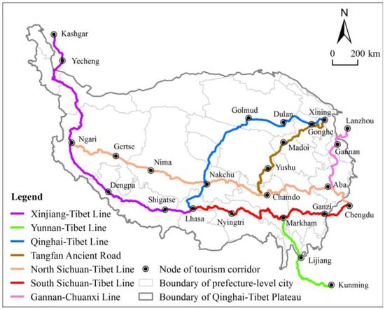
Figure 1.
The main tourism corridors in the Tibetan Plateau.
2.2. Data Source
This research mainly uses basic geographic, socio-economic, and point-of-interest (POI) data. Basic geographic data comprise elevation, vegetation coverage, land use, meteorological stations, Tibetan Plateau boundaries, and administrative divisions. Likewise, elevation, vegetation cover, and land use data are obtained from the Resource and Environment Science and Data Centre of the Chinese Academy of Sciences (https://www.resdc.cn/, accessed on 20 December 2023) at a spatial resolution of 1 km × 1 km. Equally, temperature, precipitation, and solar radiation data are gathered from the National Meteorological Data Centre (http://data.cma.cn/, accessed on 8 January 2024) spanning from 2015 to 2023. Congruently, administrative divisions are obtained from the National Earth System Science Data Centre (https://www.geodata.cn/, accessed on 15 December 2023) for the year 2023. More so, socio-economic data comprise gross domestic product (GDP) figures, a list of tourist attractions, and traffic network data. On top of that, GDP data are gathered from the China County Statistical Yearbook 2022 and local government annual reports. The list of tourist attractions is obtained from the official list published by the Ministry of Culture and Tourism of the People’s Republic of China. In like manner, traffic road network data are gathered from the Open Street Map public dataset (http://www.openstreetmap.org/, accessed on 15 January 2024). We also added POI data, which are obtained from GODE POIs, including hospitals, hotels, catering enterprises, car parks, and petrol stations. However, geological disaster points are gathered from the Global Disaster Data Platform (https://www.gddat.cn/, accessed on 20 January 2024), including landslides, avalanches, and earthquakes.
To accurately assess tourism risk along the Tibetan Plateau’s tourism corridors, this study adopts a 20 km buffer zone along the corridors for data processing, dividing it into 3 km × 3 km evaluation units. Lastly, all the data are converted into a raster size of 3 km × 3 km, laying the groundwork for subsequent GIS spatial overlay analysis.
2.3. Methodology
2.3.1. Research Framework
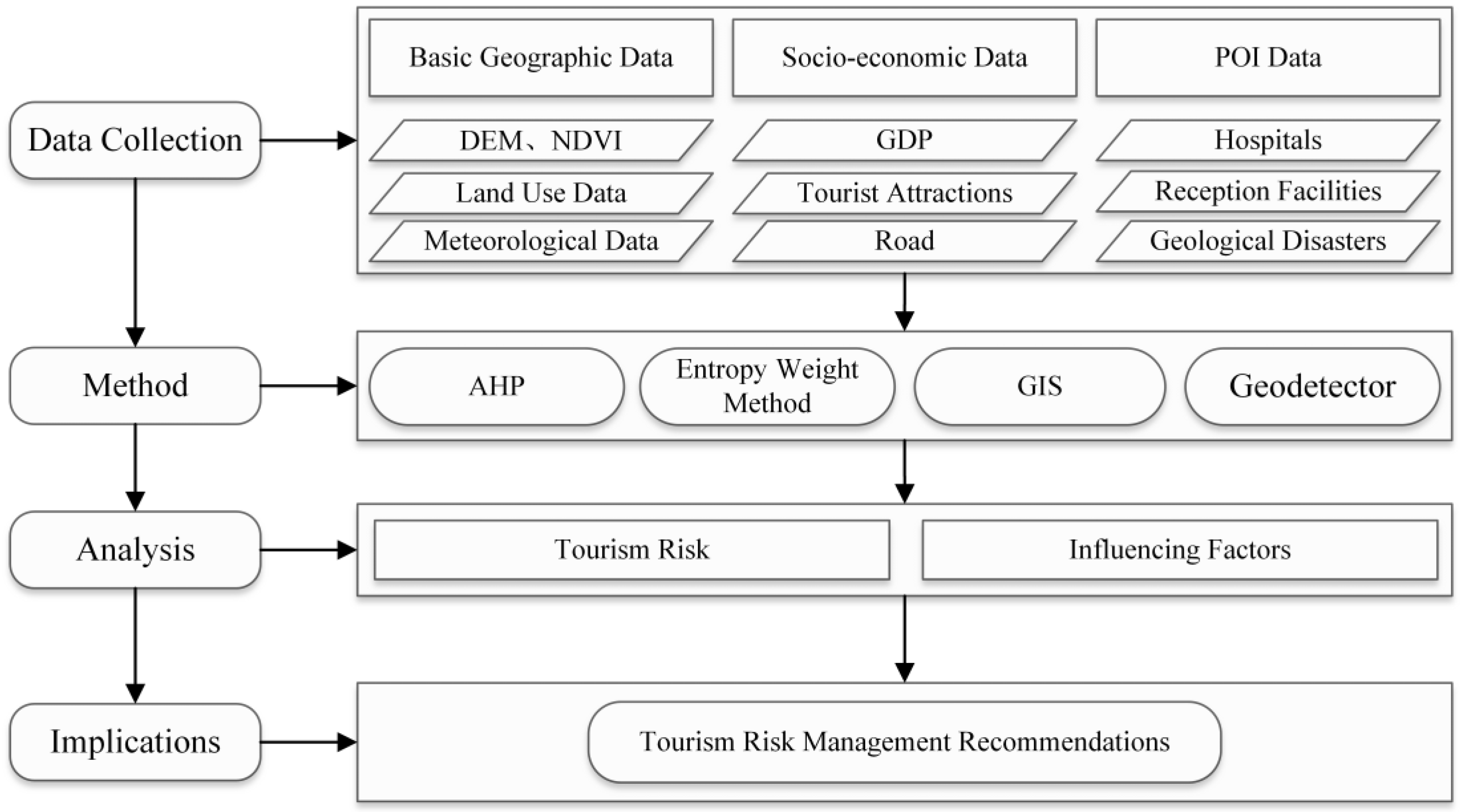
This research was conducted in the following steps: Initially, the requisite data for this study were identified based on the research objectives and acquired through field visits and various data repositories. Subsequently, GIS was utilized for data standardization to establish the research database. Next, an assessment system was developed for tourism risk within the Tibetan Plateau tourism corridors, considering the region’s natural environmental characteristics and socio-economic conditions. This is followed by the application of methods such as Analytic Hierarchy Analysis, entropy weight method, GIS spatial analysis, and Geodetector to analyze tourism risk and its influencing factors within the Tibetan Plateau tourism corridors. Finally, leveraging the findings from the tourism risk analysis and factors influencing tourism risk, policy recommendations for tourism risk management in the Tibetan Plateau region are proposed, aligning with pertinent research on tourism risk management and the specific characteristics of tourism activities in the Tibetan Plateau region. The research framework is illustrated in Figure 2.

Figure 2.
Research framework.
2.3.2. Evaluation Index System
Tourism risk assessment gauges the safety status of tourist destinations and the potential risks tourists may encounter amid the interplay of internal and external factors [8]. Existing studies have introduced various assessment systems tailored to different entities such as cities [32], tourist attractions [33,34], islands [35,36], and tourist routes [37,38]. Generally, scholars rely on disaster risk theory to formulate a tourism risk assessment system, where disaster risk is based on the hazards posed by disaster triggers, the level of risk exposure, carrier vulnerability, and disaster prevention and mitigation capabilities [39]. This theory, which incorporates both natural and social dimensions of disaster risk, facilitates scientific examination of the issue, offering insights for this study’s tourism risk assessment of the Tibetan Plateau’s tourism corridors. Accordingly, we constructed a tourism risk assessment framework for the Tibetan Plateau’s tourism corridors, focusing on hazards, vulnerability, and exposure, which resulted in the selection of nine indices, as listed in Table 1.

Table 1.
Tourism risk evaluation index system of the Tibetan Plateau’s tourism corridors.
Hazard encompasses the risk posed to tourists by various factors, such as topography, climate, vegetation, water systems, and anthropogenic activities [37]. The Tibetan Plateau, known for its intricate geological structure, is prone to widespread geological hazards [40]. Moreover, the region is characterized by rapid climate fluctuations, high altitudes, and intense ultraviolet (UV) radiation [41,42,43,44]. Therefore, five indices—geological disaster risk, extreme heat risk, extreme precipitation risk, plateau reaction risk, and UV radiation intensity—were chosen to measure hazard levels, as detailed in Table 1.
Vulnerability refers to the likelihood of tourists suffering harm when confronted with tourism risks, primarily dictated by external tourism safety conditions without considering individual differences among tourists [8]. Additionally, more timely rescue operations and higher medical care levels lead to reduced vulnerability. Consequently, two indices—rescue distance and medical care level—were selected to assess vulnerability. At the same time, rescue distance is determined by the distance between the evaluation unit and the nearest city, with shorter distances indicating swifter rescue operations. Meanwhile, medical care level is measured by the number of hospitals in the nearest city to the evaluation unit, with a higher count signifying superior medical care standards.
Exposure is a measure of the extent to which tourists are subjected to the risk environment, which is determined by the tourist’s duration of stay within the evaluation unit [33]. Likewise, tourists’ length of stay depends on the allure and capacity of tourist attractions within the evaluation unit. Therefore, two indices—tourist attraction and tourist reception capacity—are selected to assess exposure. Similarly, tourist attraction is evaluated based on the kernel density value of tourism resources, where higher values indicate greater attraction within the evaluation unit. Conversely, tourism reception capacity is appraised through the kernel density value of tourism facilities, with larger values denoting higher reception capacities within the evaluation unit.
Before conducting a comprehensive assessment of tourism risk, the natural breakpoint classification method is used to classify the indices into 1–5 classes, which helps reduce the impact of varying scales on assessment indices. Compared with alternative classification methods, the natural breakpoint classification method can maximize discrepancies between classes, thus offering a more objective reflection of assessment outcomes [45].
2.3.3. Index Weights
Determining the weight of each evaluation index is a crucial part of the multi-factor comprehensive evaluation process. This research utilizes the Analytic Hierarchy Process and entropy weight method to provide both subjective and objective assignments. While the Analytic Hierarchy Process is more subjective and can be influenced by the randomness of the evaluation process and subjective uncertainties of experts [46], the entropy weight method tends to be more objective, albeit sometimes losing information and being influenced by discrete values [47]. To address this, after computing the weights w1i from the Analytic Hierarchy Process and w2i from the entropy weight method, the principle of minimum information entropy is used to determine the final weights, which minimizes the deviation between the subjective and objective weights [48]. The specific calculation formula is as follows:
In Equation (1), wi represents the comprehensive weights, i denotes the index serial number, w1i signifies the weights from the Analytic Hierarchy Process, and w2i denotes the weights from the entropy weight method. The resultant weights are presented in Table 2.
Table 2.
Evaluation index weights.
2.3.4. Calculation of Tourism Risk
Utilizing the weighted superposition tool within ArcGIS, the hazard index, vulnerability index, and exposure index were calculated through the weighted superposition of the index layer. Subsequently, the comprehensive assessment value of tourism risk was determined by weighting the dimension layer. The calculation formula is presented as follows:
In Equation (2), R represents the tourism risk index, H denotes the hazard index, V denotes the vulnerability index, and E denotes the exposure index. WH, WV, and WE denote the weights of the three dimensions—hazard, vulnerability, and exposure, respectively. Correspondingly, WHj signifies the weight of the j-th evaluation index within the hazard dimension, while XHj represents the grade value of the j-th evaluation index within the hazard dimension. Similarly, WVj denotes the weight of the j-th evaluation index within the vulnerability dimension, and XVj signifies the grade value of the j-th evaluation index within the vulnerability dimension. Additionally, WEj represents the weight of the j-th evaluation index within the exposure dimension, with XEj denoting the grade value of the j-th evaluation index within the exposure dimension. After calculating the tourism risk and each dimension index, we employed the natural breaking point classification method to classify the tourism risk index, hazard index, vulnerability index, and exposure index into three levels: low, medium, and high.
2.3.5. Influencing Factors of Tourism Risk
In this study, Geodetector, a statistical method for detecting spatial heterogeneity and its driving factors, is employed to analyze the impacts of factors and the interactions of different factors on tourism risk in the Tibetan Plateau’s tourism corridors [49]. Primarily focusing on factor detection and interaction detection, the analysis aims to discern the role of individual factors and their interplay. Eight factors were selected from three dimensions: environment conducive to disasters, exposure to risk, and security conditions, considering the natural environment of the Tibetan Plateau and the conditions of risk formation (Table 3). In addition, the criterion of an environment conducive to disasters encompasses four factors: topography, vegetation, precipitation, and temperature. The criterion of exposure to risk includes two factors: tourism location and tourism resource endowment. Meanwhile, the criterion of security conditions comprises two factors: economic foundation and accessibility. Subsequently, using the tourism risk index as the dependent variable and the eight factors as independent variables, the “GD” Geodetector tool in R was employed to calculate the degree of influence of each factor on the tourism risk of the Tibetan Plateau’s tourism corridors.
Table 3.
Influencing factors of tourism risk of the Tibetan Plateau’s tourism corridors.
3. Results
3.1. Tourism Risk Analysis
Tourism risk analysis reveals a hierarchy from high to low across the seven tourism corridors: Yunnan–Tibet Line, north Sichuan–Tibet Line, Xinjiang–Tibet Line, Tangfan Ancient Road, Qinghai–Tibet Line, south Sichuan–Tibet Line, and Gannan–Chuanxi Line (Table 4). The Yunnan–Tibet Line traverses the Hengduan Mountain and Three Parallel Rivers areas, featuring intricate geological formations and frequent natural disasters, alongside popular tourist destinations like Kunming, Dali, and Lijiang, coupled with numerous world-class tourist resources. Consequently, its heightened attractiveness to tourists also exposes it to greater risks, hence securing the top rank in tourism risk assessment among all corridors. Similarly, the north Sichuan–Tibet Line, Xinjiang–Tibet Line, Tangfan Ancient Road, and Qinghai–Tibet Line boast high average altitudes, encompassing vast stretches of uninhabited areas characterized by high altitudes and oxygen scarcity, navigating through over 1000 km of deserts, permafrost layers, and perennially snow-capped mountains, thus meriting relatively high tourism risk ratings. Conversely, the south Sichuan–Tibet Line and Gannan–Chuanxi Line, with lower altitudes, favorable climatic conditions, and robust economic foundations along their corridors, earn relatively lower tourism risk rankings. Moreover, corridors with elevated tourism risk rankings also exhibit higher hazard and vulnerability, emphasizing the pivotal role of hazard and vulnerability in driving tourism risk, thereby necessitating a focus on bolstering disaster risk monitoring and early warning systems, alongside enhancing security conditions for risk mitigation.
Table 4.
Value and rank of tourism corridors’ hazard, vulnerability, exposure, and tourism risk.
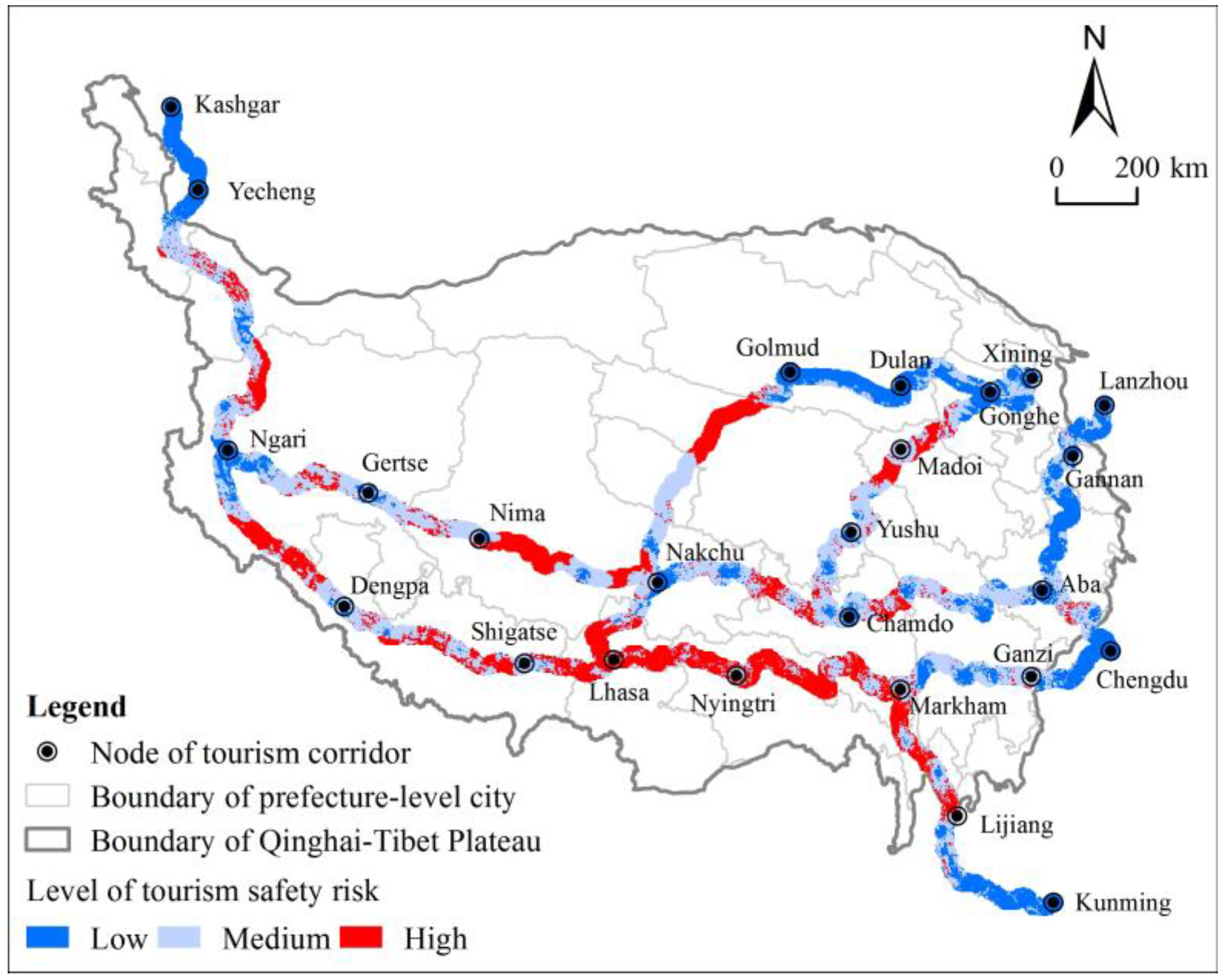
In terms of spatial distribution (Figure 3), high tourism risk areas primarily emerge along specific sections: the Lijiang–Markham stretch of the Yunnan–Tibet Line; the Wenchuan–Lixian, Ganzi–Dege, Leiwuqi–Deqing, Bange–Nima, and Gaize–Geji segments of the north Sichuan–Tibet Line; the Pishan–Ritu, Pulan–Dengpa, and Saga–Lhasa portions of the Xinjiang–Tibet Line; the Madoi–Yushu Section of the Tangfan Ancient Road; the Golmud–Totuohe and Dangxiong–Lhasa sections of the Qinghai–Tibet Line; the Markham–Lhasa segment of the south Sichuan–Tibet Line; as well as the Lixian–Wenchuan section of the Gannan–Chuanxi Line. Among these, the Pishan–Ritu, Pulan–Dengpa, and Saga–Lhasa sections of the Xinjiang–Tibet Line, the Madoi–Yushu segment of the Tangfan Ancient Road, Golmud–Totuohe, and Dangxiong–Lhasa sections of the Qinghai–Tibet Line, and the Bango–Nima and Changze–Geji sections of the north Sichuan–Tibet Line predominantly traverse high-altitude uninhabited regions characterized by severe cold and oxygen deficiency alongside inadequate infrastructure, thereby exhibiting elevated hazards and vulnerability levels, resulting in relatively heightened tourism risk. The Lijiang–Markham stretch of the Yunnan–Tibet Line, the Markham–Lhasa segment of the south Sichuan–Tibet Line, the Wenchuan–Lixian, Ganzi–Dege, and Leiwuqi–Deqing sections of the north Sichuan–Tibet Line, and the Lixian–Wenchuan section of the Gannan–Chuanxi Line largely traverse the Hengduan Mountains Areas, featuring rugged topography and frequent geological disasters, consequently experiencing heightened tourism risk levels as well. Notably, these high-risk areas are predominantly synonymous with high-hazard and high-vulnerability regions, reinforcing the pivotal role of hazard and vulnerability in influencing tourism risk.
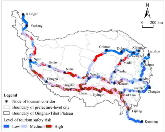
Figure 3.
Tourism risk spatial distribution of tourism corridors in the Tibetan Plateau.
3.2. Influencing Factors Analysis
3.2.1. Single Influencing Factor Analysis
Factor detection is used to detect the individual influence degree of each factor on tourism risk in the Tibetan Plateau’s tourism corridors, expressed by the q-value. The results of factor detection in Table 5 show significant p-values for all indexes, indicating the validity of the selected factors. In descending order of q-value, the influence degree of each factor on tourism safety risk is X6 (tourism resource endowment), X5 (tourism location), X3 (precipitation), X7 (economic foundation), X4 (temperature), X2 (vegetation), X8 (accessibility), and X1 (topography).
Table 5.
Results of factor detection.
Among these factors, X6 (tourism resource endowment) exhibits the greatest influence degree, signifying its critical role in tourism risk within the Tibetan Plateau’s tourism corridors. Tourism resource endowment shapes tourist attraction, a vital prerequisite for tourism activities, drawing a substantial tourist influx to regions with high-quality tourism resources. Consequently, this not only heightens risk exposure but also complicates local tourism safety management. Following closely, X5 (tourism location) ranks second, underscoring the significance of tourism resource endowment. Hence, proximity to tourist attractions correlates with mature tourism development, robust tourism infrastructure, heightened tourism reception capacity, and extended tourist stays. Moreover, regions with advanced tourism development necessitate enhanced safety management and security measures, given the immeasurable repercussions of tourism safety incidents.
Additionally, X3 (precipitation) and X7 (economic foundation) constitute significant factors influencing tourism risk in the Tibetan Plateau’s tourism corridors. The Tibetan Plateau experiences abundant rainfall, often leading to landslides, mudslides, and other disasters, posing substantial challenges to local tourism safety management. Hence, establishing a disaster warning mechanism for high-risk areas becomes imperative, enabling tourists to preemptively mitigate risks. The effectiveness of tourist rescue operations profoundly impacts tourist welfare during emergencies. Regions with good economic foundations typically exhibit higher rescue medical capabilities, ensuring prompt and efficient assistance for injured tourists, and serving as the ultimate safety safeguard. Consequently, areas with solid economic foundations should augment investment in tourism security, enhance regional medical capabilities, and establish dedicated emergency response mechanisms to guarantee that tourists receive timely and effective care.
3.2.2. Factor Interaction Analysis
Factor interaction analysis is employed to determine whether the interplay between different factors amplifies or diminishes the influence on tourism risk in the Tibetan Plateau’s tourism corridors. Based on the results of interaction detection in Table 6, the interaction values of X6 (tourism resource endowment) with X1 (topography), X2 (vegetation), X3 (precipitation), X4 (temperature), X5 (tourism location), X7 (economic foundation), and X8 (accessibility) are 0.56, 0.57, 0.63, 0.59, 0.55, 0.64, and 0.52, respectively. These values exceed the sole effect value of 0.52 for X6 (tourism resource endowment) alone, indicating that the interaction between X6 and other factors exacerbates the tourism risk of the corridors in the Tibetan Plateau. Notably, the highest interaction value is observed between X6 (tourism resource endowment) and X7 (economic base), underscoring their profound impacts on tourism risk in the Tibetan Plateau’s corridors.
Table 6.
Results of interaction detection.
Likewise, the interaction value between any other two factors surpasses the singular effect value of either factor, signifying that a single factor exerts a minor influence on tourism risk in the Tibetan Plateau’s corridors. Instead, factor interactions augment the overall impact on tourism risk. Hence, the tourism risk in the Tibetan Plateau’s corridors stems from multiple influencing factors rather than a single factor. Consequently, in formulating tourism safety management strategies, careful consideration of each factor’s characteristics and the interaction effects is imperative. Implementing tailored and diversified regulatory strategies is essential to mitigate the safety risks faced by tourists.
4. Discussion and Implications
4.1. Discussion
The findings of this study reveal that high tourism risk areas predominantly cluster along the Yunnan–Tibet Line, north Sichuan–Tibet Line, Xinjiang–Tibet Line, Tangfan Ancient Road, Qinghai–Tibet Line, and south Sichuan–Tibet Line. This observation aligns with prior studies carried out by Jianchao et al. (2007) [37], Xi et al. (2012) [38], and Shi et al. (2014) [50], indicating the credibility and reference significance of the assessment indexes and system constructed herein. However, disparities emerge when scrutinizing tourism risk along the corridors compared to previous research. For instance, while Shi Fei et al. (2014) study identified Markham, Basu, and Nyingtri as high-risk areas along the Sichuan–Tibet Highway, we observed relatively low tourism risk in the urban centers of Markham, Basu, and Nyingtri, with high-risk areas distributed in the transitional zones between towns. In addition, the variance stems from differing evaluation units, with the former employing town-to-town zones and this study utilizing grids. The grid-based evaluation offers higher accuracy compared to zonal assessments, enabling a more precise depiction of tourism risk spatial distribution.
Moreover, the analysis of factors influencing tourism risk in the Tibetan Plateau’s corridors highlights tourism resource endowment, tourism location, precipitation, and economic foundation as primary influencers. Importantly, the interaction among these factors intensifies the impact on tourism risk, providing valuable insights into the formation mechanism of tourism risk in the Tibetan Plateau’s corridors and guiding tourism safety management practices in the region. This exploration contributes to enriching the body of research on tourism risk and provides practical implications for enhancing tourism safety measures.
Nevertheless, this study still has some shortcomings. The construction of the evaluation index system has primarily focused on natural risks, neglecting social risk factors associated with tourism, which warrants further refinement and optimization. Additionally, due to data limitations, the assessment has only evaluated the objective state of tourism risk and lacks a corresponding assessment of subjective risk perception among tourists. Furthermore, the assessment method adheres to the traditional comprehensive approach and incorporates subjective judgments to some extent in index quantification and weight determination. In the future, the integration of methods like random forests and neural networks is essential. Furthermore, enhancing the inclusion of relevant indexes related to social risk factors is imperative. Introducing tourism big data such as tourists’ trajectories and online travelogues, and exploring the interactions between tourists and destinations, will facilitate the proposal of new research and the development of a novel tourism risk assessment framework.
4.2. Policy Implications
Based on the preceding conclusions, this study proposes the following recommendations: Firstly, it is recommended to enhance the monitoring and early warning of disaster risks in areas with high tourism risk [51]. Collaborative efforts between the tourism sector and geological and meteorological departments are pivotal in establishing a tourism disaster warning platform. This platform would enable real-time monitoring of disaster risk sections such as Hetian–Shigatse, Nagchu–Ngari, Golmud–Nakchu, Wulan–Madoi, Nyingtri–Shannan, and Deqin–Markham. By leveraging big data and the internet, timely early warnings can be accurately disseminated to tourists, enabling them to preemptively mitigate risks.
Secondly, it is recommended to bolster investment in tourism safety across the Tibetan Plateau region and enhance tourism safety management and security conditions [52]. Establishing tourism safety management centers in popular tourist destinations like Lhasa and Xining is essential. These centers would coordinate and manage cross-regional tourism safety incidents, with a particular focus on improving the region’s tourism safety management capabilities. This includes formulating robust tourism emergency rescue plans, issuing tourism safety advisories, receiving tourism emergency information, and coordinating tourism emergency response efforts. Additionally, establishing tourism rescue and emergency response teams and enhancing basic tourism rescue facilities are imperative steps toward effectively fortifying the Tibetan Plateau region’s tourism safety capacity.
Thirdly, comprehensive consideration of both natural and socio-economic conditions along various tourism corridors is crucial for formulating targeted strategies for tourism risk prevention and control [42]. This entails acquiring a scientific understanding of the environmental factors that contribute to disasters along these corridors, identifying the mechanisms and patterns of various risk occurrences, and evaluating the potential consequences of different risks to devise tailored management plans.
Similarly, tourists should equip themselves with essential knowledge and skills related to plateau tourism before embarking on journeys to such high-altitude regions, including coping with altitude sickness and appropriate equipment usage. Before selecting a destination, tourists ought to thoroughly assess the tourism risk levels of each location, plan their itineraries sensibly, avoid high-risk areas, and establish contingency plans. While traveling, staying abreast of tourism risk updates provided by local authorities and tourist attractions is imperative, enabling tourists to take necessary precautions. Additionally, familiarity with local emergency protocols and contact information is essential for promptly seeking assistance in case of emergencies.
5. Conclusions
Safety constitutes a fundamental prerequisite for the sustainable and wholesome advancement of tourism. Conducting tourism risk assessments stands as an initial imperative in the trajectory of tourism development. Previous examinations of tourism risk assessments have afforded scant attention to the tourism risk inherent in cross-regional tourism corridors and have lacked in-depth analyses concerning the factors influencing tourism risk. Hence, this study focuses on tourism corridors within the Tibetan Plateau region and scrutinizes the tourism risk and factors influencing it. Findings reveal an overall high tourism risk across tourism corridors in the Tibetan Plateau region, with high-risk areas predominantly concentrated along the Yunnan–Tibet Line, north Sichuan–Tibet Line, Xinjiang–Tibet Line, Tangfan Ancient Road, Qinghai–Tibet Line, and south Sichuan–Tibet Line. Moreover, the Geodetector methodology is employed to further dissect the factors influencing the tourism risk within each corridor. The results show that tourism resource endowment, tourism location, precipitation, and economic foundation emerge as principal factors influencing tourism risk. In locales boasting elevated tourism development levels, corresponding enhancements in security conditions and management are imperative. Therefore, tourist destinations should augment investments in tourism safety, bolster regional medical capabilities, and establish specialized emergency response mechanisms to ensure tourists receive prompt and efficacious rescue and medical assistance. Additionally, recognizing the amplifying influence of factor interactions on tourism risk underscores the necessity of considering such interactions comprehensively when devising tourism safety management strategies. This study not only offers insights applicable to the assessment of risk in other trans-regional tourism corridors but also provides a scientific foundation for tourism safety management initiatives within the Tibetan Plateau region.
From the perspective of cross-regional tourism corridors, this study provides new research ideas and methods for the study of tourism risk assessment, which can make up for the lack of research on cross-regional tourism corridor risk. Meanwhile, this study also constructs a quantitative evaluation system for the risk of tourism corridors in the Tibetan Plateau, which can provide a reference for the risk assessment of other cross-regional tourism corridors. Additionally, this study explores the influencing factors of tourism corridor risk in the Tibetan Plateau, which enriches the research content of tourism risk influencing factors.
Through an in-depth analysis of factors such as tourism resource endowment, location, precipitation, and economic foundation, it underscores the multifaceted nature of tourism risk and the imperative for tailored safety measures. By emphasizing the need for enhanced security conditions and strategic investments in tourism safety, this research provides a vital blueprint for fostering sustainable tourism development in the Tibetan Plateau and beyond. Moreover, recognizing the amplifying impact of factor interactions on tourism risk underscores the importance of holistic approaches in crafting effective safety management strategies. This study serves as a cornerstone for future endeavors in understanding and mitigating tourism risk in cross-regional tourism corridors, offering invaluable insights for policymakers, stakeholders, and practitioners alike.
However, a limitation of this study lies in its focus primarily on objective risk factors, neglecting subjective risk perceptions of tourists and social risk factors, suggesting a need for further research integrating these aspects for a more comprehensive understanding of tourism risk. For future studies, it is recommended to explore innovative methodologies such as random forests and neural networks while expanding the scope to include subjective risk perceptions and social risk factors. This holistic approach would provide a more nuanced understanding of tourism risk dynamics, ultimately contributing to more effective safety management strategies in tourism corridors.
Author Contributions
Conceptualization, Ziqiang Li and Jianchao Xi; methodology, Ziqiang Li and Sui Ye; validation, Ziqiang Li, Sui Ye, and Jianchao Xi; writing—original draft preparation, Ziqiang Li; writing—review and editing, Ziqiang Li and Jianchao Xi; visualization, Sui Ye; supervision, Jianchao Xi; project administration, Ziqiang Li; funding acquisition, Ziqiang Li. All authors have read and agreed to the published version of the manuscript.
Funding
This research was funded by the Second Tibetan Plateau Scientific Expedition and Research Program, grant number 2019QZKK1004.
Data Availability Statement
The data presented in this study are available on request from the corresponding author.
Conflicts of Interest
The authors declare no conflicts of interest.
References
- Aliperti, G.; Sandholz, S.; Hagenlocher, M.; Rizzi, F.; Frey, M.; Garschagen, M. Tourism, crisis, disaster: An interdisciplinary approach. Ann. Tour. Res. 2019, 79, 102808. [Google Scholar] [CrossRef]
- Hopkins, D. Crises and tourism mobilities. J. Sustain. Tour. 2021, 29, 1423–1435. [Google Scholar] [CrossRef]
- Akram, K.; Al Mamun, M.; Raza, S.A.; Suleman, M.T. Global geopolitical crisis and tourism development in the USA. Curr. Issues Tour. 2023, 26, 1–17. [Google Scholar] [CrossRef]
- Shahzad, S.J.H.; Hoang, T.H.V.; Bouri, E. From pandemic to systemic risk: Contagion in the US tourism sector. Curr. Issues Tour. 2022, 25, 34–40. [Google Scholar] [CrossRef]
- Lee, C.-C.; Chen, M.-P. The impact of COVID-19 on the travel and leisure industry returns: Some international evidence. Tour. Econ. 2022, 28, 451–472. [Google Scholar] [CrossRef]
- Ye, S.; Xi, J. Identification and evaluation of tourism corridor: A case study of Qinghai-Tibet Plateau. Acta Geogr. Sin. 2023, 78, 2630–2644. [Google Scholar] [CrossRef]
- Zhang, B.; Zhou, L.; Yin, Z.; Zhou, A.; Li, J. Study on the Correlation Characteristics between Scenic Byway Network Accessibility and Self-Driving Tourism Spatial Behavior in Western Sichuan. Sustainability 2023, 15, 14167. [Google Scholar] [CrossRef]
- Li, Z.; Xi, J.; Zhang, R. Assessment of Tourism Risk along the Yunnan-Tibet Highway, China. Mt. Res. 2022, 40, 753–763. [Google Scholar] [CrossRef]
- Shi, S.; Liu, M.; Xi, J. Hierarchical Structure and Organizational Model of County Tourism Network of the Tibetan Plateau. Land 2022, 11, 1880. [Google Scholar] [CrossRef]
- Ye, C.-m.; Wei, R.-l.; Ge, Y.-g.; Li, Y.; Marcato Junior, J.; Li, J. GIS-based spatial prediction of landslide using road factors and random forest for Sichuan-Tibet Highway. J. Mt. Sci. 2022, 19, 461–476. [Google Scholar] [CrossRef]
- Secaida, L.P.Y.; Mori, S.; Nomura, R. Assessment of Natural Disasters Impact on Cultural Mayan Heritage Spaces in Remotes Villages of Guatemala: Case of Black Salt. Sustainability 2023, 15, 12591. [Google Scholar] [CrossRef]
- Chan, C.-S.; Nozu, K.; Cheung, T.O.L. Tourism and natural disaster management process: Perception of tourism stakeholders in the case of Kumamoto earthquake in Japan. Curr. Issues Tour. 2020, 23, 1864–1885. [Google Scholar] [CrossRef]
- Seraphin, H. Natural disaster and destination management: The case of the Caribbean and hurricane Irma. Curr. Issues Tour. 2019, 22, 21–28. [Google Scholar] [CrossRef]
- Rutty, M.; Hewer, M.; Knowles, N.; Ma, S. Tourism & climate change in North America: Regional state of knowledge. Journal of Sustainable Tourism 2022. [CrossRef]
- Fang, Y.; Trupp, A.; Hess, J.S.; Ma, S. Tourism under climate crisis in Asia: Impacts and implications. J. Sustain. Tour. 2022, 30, 1–17. [Google Scholar] [CrossRef]
- Wilkins, E.J.; Akbar, H.; Saley, T.C.; Hager, R.; Elkin, C.M.; Belmont, P.; Flint, C.G.; Smith, J.W. Climate Change and Utah Ski Resorts: Impacts, Perceptions, and Adaptation Strategies. Mt. Res. Dev. 2021, 41, R12–R23. [Google Scholar] [CrossRef]
- Karimi, M.S.; Khezri, M.; Razzaghi, S. Impacts of regional conflicts on tourism in Africa and the Middle East: A spatial panel data approach. Curr. Issues Tour. 2022, 25, 1649–1665. [Google Scholar] [CrossRef]
- Pandey, D.K.; Kumar, R. Russia-Ukraine War and the global tourism sector: A 13-day tale. Curr. Issues Tour. 2023, 26, 692–700. [Google Scholar] [CrossRef]
- Hailemariam, A.; Ivanovski, K. The impact of geopolitical risk on tourism. Curr. Issues Tour. 2021, 24, 3134–3140. [Google Scholar] [CrossRef]
- Papagianni, E.; Evgenidis, A.; Tsagkanos, A.; Megalooikonomou, V. Tourism Demand in the Face of Geopolitical Risk: Insights from a Cross-Country Analysis. J. Travel Res. 2023, 62, 1–26. [Google Scholar] [CrossRef]
- Agarwal, S.; Page, S.J.; Mawby, R. Tourist security, terrorism risk management and tourist safety. Ann. Tour. Res. 2021, 89, 103207. [Google Scholar] [CrossRef]
- Vereb, V.; Nobre, H.; Farhangmehr, M. Cosmopolitan tourists: The resilient segment in the face of terrorism. Tour. Manag. Perspect. 2020, 33, 100620. [Google Scholar] [CrossRef]
- Karamelikli, H.; Khan, A.A.; Karimi, M.S. Is terrorism a real threat to tourism development? Analysis of inbound and domestic tourist arrivals in Turkey. Curr. Issues Tour. 2020, 23, 2165–2181. [Google Scholar] [CrossRef]
- Bassil, C.; Saleh, A.S.; Anwar, S. Terrorism and tourism demand: A case study of Lebanon, Turkey and Israel. Curr. Issues Tour. 2019, 22, 50–70. [Google Scholar] [CrossRef]
- Causevic, A. Impact of the COVID-19 Pandemic on Travel Behavior and Travel Mode Preferences: The Example of Bosnia and Herzegovina. Sustainability 2023, 15, 10701. [Google Scholar] [CrossRef]
- Williams, A.M.; Chen, J.L.; Li, G.; Balaz, V. Risk, uncertainty and ambiguity amid COVID-19: A multi-national analysis of international travel intentions. Ann. Tour. Res. 2022, 92, 103346. [Google Scholar] [CrossRef] [PubMed]
- Ai, J.; Lv, X.; Gursoy, D. Impact of social media posts on travelers’ attitudes and behaviors towards a destination after a natural disaster: Moderating role of the source of the post. J. Sustain. Tour. 2023, 31, 2460–2478. [Google Scholar] [CrossRef]
- Pyke, J.; Lindsay-Smith, G.; Gamage, A.; Shaikh, S.; Nguyen, V.K.; de Lacy, T.; Porter, C. Building destination resilience to multiple crises to secure tourism’s future. Asia Pac. J. Tour. Res. 2021, 26, 1225–1243. [Google Scholar] [CrossRef]
- Casal-Ribeiro, M.; Boavida-Portugal, I.; Peres, R.; Seabra, C. Review of Crisis Management Frameworks in Tourism and Hospitality: A Meta-Analysis Approach. Sustainability 2023, 15, 12047. [Google Scholar] [CrossRef]
- Reddy, M.V.; Boyd, S.W.; Nica, M. Towards a post-conflict tourism recovery framework. Ann. Tour. Res. 2020, 84, 102940. [Google Scholar] [CrossRef] [PubMed]
- Rong, T.; Xu, S.; Lu, Y.; Tong, Y.; Yang, Z. Quantitative Assessment of Spatial Pattern of Geodiversity in the Tibetan Plateau. Sustainability 2023, 15, 299. [Google Scholar] [CrossRef]
- Zhang, J.; Zhou, G. Construction of index system for urban tourism safety with empirical study-a case study of Hangzhou. J. Saf. Sci. Technol. 2015, 11, 121–126. [Google Scholar] [CrossRef]
- Sun, Y.; Yang, Q.; Chen, P. Dynamic Evaluation of Tourism Safety Risk in the Changbai Mountains Scenic Spot. Sci. Geogr. Sin. 2019, 39, 770–778. [Google Scholar] [CrossRef]
- Yongguang, Z.O.U.; Xiangmin, Z. Safety Evaluation Model and Empirical Study for Tourism Scenic Spots. China Saf. Sci. J. 2011, 21, 156–162. [Google Scholar] [CrossRef]
- Becken, S.; Mahon, R.; Rennie, H.G.; Shakeela, A. The tourism disaster vulnerability framework: An application to tourism in small island destinations. Nat. Hazards 2014, 71, 955–972. [Google Scholar] [CrossRef]
- Tsai, C.-H.; Chen, C.-W. An earthquake disaster management mechanism based on risk assessment information for the tourism industry-a case study from the island of Taiwan. Tour. Manag. 2010, 31, 470–481. [Google Scholar] [CrossRef]
- Xi, J.; Zhang, R.; Zhao, M. Travel Risk Evaluation along the Qinghai-Tibet Railway. J. Mt. Sci. 2012, 30, 737–746. [Google Scholar] [CrossRef]
- Xi, J.; Liu, H.; Qi, X.; Wu, P. The Risk Assessment Model of Tourism Destination-taking ten Adventure Tourism Lines as A Case Study. J. Mt. Sci. 2007, 25, 370–375. [Google Scholar] [CrossRef]
- Haolong, L.I.U.; Quansheng, G.E.; Jianchao, X.I. Disaster Risks Assessment of Regional Tourism Resources: A Case Study of Inner Mongolia Keshiketeng Banner. Resour. Sci. 2007, 29, 118–125. [Google Scholar] [CrossRef]
- Cui, P.; Jia, Y. Mountain hazards in the Tibetan Plateau: Research status and prospects. Natl. Sci. Rev. 2015, 2, 397–399. [Google Scholar] [CrossRef]
- Zha, R.; Sun, G.; Dong, Z.; Yu, Z. Assessment of Atmospheric Oxygen Practical Pressure and Plateau Reaction of Tourists in the Qinghai-Tibet Plateau. Ecol. Environ. Sci. 2016, 25, 92–98. [Google Scholar] [CrossRef]
- Wang, S.; Wei, Y.; Niu, C.; Zhang, Y. Comprehensive risk management of multiple natural disasters on the Qinghai-Tibet Plateau. J. Glaciol. Geocryol. 2021, 43, 1848–1860. [Google Scholar] [CrossRef]
- Wei, Y.; Wang, S.; Fang, Y.; Nawaz, Z. Integrated assessment on the vulnerability of animal husbandry to snow disasters under climate change in the Qinghai-Tibetan Plateau. Glob. Planet. Change 2017, 157, 139–152. [Google Scholar] [CrossRef]
- Li, X.; Wang, Q.; Hu, Y.; Jing, L.; Ge, W. Spatio-temporal changes in tourism climate index on the Tibetan Plateau over the last 42 years. Curr. Issues Tour. 2023, 26, 3929–3933. [Google Scholar] [CrossRef]
- Li, N.; Xu, G. Grid analysis of land use based on natural breaks (jenks) classification. Bull. Surv. Mapp. 2020, 65, 106–110. [Google Scholar] [CrossRef]
- Habib, M.H.R.; Rahman, M.; Uddin, M.M.; Shimu, N.J.; Hasan, M.; Alam, M.J.; Islam, M.S. Application of AHP and geospatial technologies to assess ecotourism suitability: A case study of Saint Martin’s Island in Bangladesh. Reg. Stud. Mar. Sci. 2024, 70, 103357. [Google Scholar] [CrossRef]
- Pan, H.; Yang, Y.; Zhang, W.; Xu, M. Research on Coupling Coordination of China’s Urban Resilience and Tourism Economy-Taking Yangtze River Delta City Cluster as an Example. Sustainability 2024, 16, 1247. [Google Scholar] [CrossRef]
- Wang, Z.; Liang, L.; Chu, X.; Li, J. Examining the Coordination Effect and Interactive Stress between Tourism Economy and Eco-environment in the Tibetan Plateau. J. Geo-Inf. Sci. 2019, 21, 1352–1366. [Google Scholar] [CrossRef]
- Meng, X.; Li, X.; Hu, G.; Zhang, Z.; Zhang, H.; Huang, C.; Han, J. Toward integrated governance of urban CO2 emissions in China: Connecting the “codes” of global drivers, local causes, and indirect influences from a multi-perspective analysis. Cities 2023, 134, 104181. [Google Scholar] [CrossRef]
- Shi, F.; Liu, F.; Li, C.; Cai, R.; Chen, R. Risk Analysis of Tourism Security along the Sichuan-Tibet Highway. Areal Res. Dev. 2014, 33, 115–120. [Google Scholar] [CrossRef]
- Tsai, C.-H.; Chen, C.-W. The establishment of a rapid natural disaster risk assessment model for the tourism industry. Tour. Manag. 2011, 32, 158–171. [Google Scholar] [CrossRef]
- Becken, S.; Hughey, K.F.D. Linking tourism into emergency management structures to enhance disaster risk reduction. Tour. Manag. 2013, 36, 77–85. [Google Scholar] [CrossRef]
Disclaimer/Publisher’s Note: The statements, opinions and data contained in all publications are solely those of the individual author(s) and contributor(s) and not of MDPI and/or the editor(s). MDPI and/or the editor(s) disclaim responsibility for any injury to people or property resulting from any ideas, methods, instructions or products referred to in the content. |
© 2024 by the authors. Licensee MDPI, Basel, Switzerland. This article is an open access article distributed under the terms and conditions of the Creative Commons Attribution (CC BY) license (https://creativecommons.org/licenses/by/4.0/).