Article

The Geospatial Crowd: Emerging Trends and Challenges in Crowdsourced Spatial Analytics

College of Computing and Informatics, Saudi Electronic University, Ryiadh 11673, Saudi Arabia
ISPRS Int. J. Geo-Inf. 2024, 13(6), 168; https://doi.org/10.3390/ijgi13060168
Submission received: 16 March 2024 / Revised: 13 May 2024 / Accepted: 15 May 2024 / Published: 21 May 2024

Abstract

:
Crowdsourced spatial analytics is a rapidly developing field that involves collecting and analyzing geographical data, utilizing the collective power of human observation. This paper explores the field of spatial data analytics and crowdsourcing and how recently developed tools, cloud-based GIS, and artificial intelligence (AI) are being applied in this domain. This paper examines and discusses cutting-edge technologies and case studies in different fields of spatial data analytics and crowdsourcing used in a wide range of industries and government departments such as urban planning, health, transportation, and environmental sustainability. Furthermore, by understanding the concerns associated with data quality and data privacy, this paper explores the potential of crowdsourced data while also examining the related problems. This study analyzes the obstacles and challenges related to “geospatial crowdsourcing”, identifying significant limitations and predicting future trends intended to overcome the related challenges.

1. Introduction

Geospatial data have become important issues in the research community since they play an essential role in shaping the world. Geospatial data that include geolocations have become leading forces in many fields rather than a niche area. The optimization of urban planning and healthcare, the monitoring of environmental sustainability, and the improvement of transportation are a few areas where geospatial data have been applied, indicating their importance in today’s world [1,2]. In addition, spatial data analytics and crowdsourcing are combining human input with information science and geology, which will impact many dynamic and influential fields that span several disciplines [3,4]. It is becoming vital to recognize the spatial connections among diverse data points that have been collected from many sources, resulting in large volumes of spatial data. Therefore, this paper explores this multidisciplinary intersection and highlights its great value in today’s data-driven society. This combination of crowdsourcing data with spatial data analytics has opened up many new possibilities in several areas such as disaster management, social sciences, urban planning, and traffic management. The paper aims to show that this combination has become essential to decision-making procedures, community engagement, and innovative solutions to real-world problems.
With advanced analytical tools, the field of spatial data analytics is becoming increasingly essential due to the integration of numerous data sources. The combination of geospatial data analytics and crowdsourcing has led to significant developments in data science and urban planning [5,6] involving geographic information systems (GISs) and cartography techniques pt1, ptB3, Extrw. With the introduction of digital mapping, GPS-enabled devices have completely transformed the collecting, processing, and managing of spatial data [3,7]. This advancement in technology has, without a doubt, made it possible to integrate crowdsourced data, contributed to by the general public, thereby achieving more dynamic and up-to-date information [8,9]. The field of spatial data analytics has evolved to include diverse data sources, cutting-edge analytical tools, and participatory data collection methods. Crowdsourcing has not only enriched the depth of the data but has also led to the development of more effective data processing and analysis techniques [10,11]. The utilization of integrated data has contributed significantly to the decision-making in crucial fields such as traffic flow and transportation, environmental sustainability, city infrastructure and planning, and urban development. All the advancements made in these areas of human activity have been facilitated by modern technologies, such as machine learning algorithms and cloud-based platforms that can achieve unprecedented levels of accuracy and efficiency when processing and interpreting complex spatial datasets [9,12].
The scope of this research extends beyond explaining the new technologies and their impact on crowdsourcing data and spatial data analytics; it comprises a more thorough investigation of spatial data analysis and public engagement and the potential that this collaboration offers. Furthermore, what motivates this research is the fact that although this new development has advantages, it also gives rise to several problems that need to be addressed. Handling the technological difficulties of various sizes of datasets, guaranteeing inclusiveness in data contribution, and negotiating moral implications of data privacy protection are some examples of the advantages. Moreover, this research investigates technological developments such as artificial intelligence (AI) and the Internet of Things (IoT), and how these can be applied to give us a better understanding of geographical data and how it can be utilized. Apart from examining the current state-of-the-art technology, in this study, we also identify and analyze the complex issues that still need to be addressed by investigating several case studies comprising cities around the world. These include problems associated with spatial data privacy, ethical data usage, and equal involvement in crowdsourcing efforts in the context of healthcare, transportation, environment, and urban development.
This paper is structured as follows: Section 2 explores state-of-the-art spatial data analytics for crowdsourcing, covering current technologies such as AI and cloud-based GIS, along with a discussion on emerging technologies in geospatial data. In Section 3, critical factors shaping methodologies are discussed, focusing on data quality and reliability and addressing concerns associated with privacy and security and factors influencing the trends of crowdsourced spatial analytics. In Section 4, this paper explores several case studies on urban planning, public health, environmental monitoring, traffic congestion analysis, and disaster response and management. Section 5 presents a discussion of the challenges, limitations, and future trends in the field. Section 6 concludes this work.

2. State-of-the-Art in Spatial Data Analytics for Crowdsourcing

In this section, we explore the most current technologies that are transforming the field of geospatial data analysis. This includes a thorough examination of both established technologies that are poised to revolutionize our use of geospatial data: AI-enhanced cloud-based GIS and the rapidly growing Small Outline Automated Reporting Systems, as well as emerging technologies.

2.1. The Rise of AI

The landscape of GIS is being reshaped by the powerful duo of AI and machine learning (ML). These technologies are enabling us to derive deeper insights from vast geospatial datasets, automate tedious tasks, and even predict future scenarios based on patterns emerging from the data. Imagine vast satellite images being analyzed in seconds, revealing subtle changes in land cover or pinpointing illegal deforestation activities. This is the power of AI-powered image recognition [13,14].
Additionally, imagine being able to rapidly assess years of satellite images to detect deforestation activities or make very precise and timely predictions about agricultural yield. These are the AI capabilities of predictive modeling and image recognition [12,14]. However, image analysis is just one capability of AI and ML. By automating laborious chores like data cleaning and feature extraction, AI and ML enable human professionals to concentrate on higher-order tasks such as model construction and interpretation [15]. In addition to analyzing images, machine learning techniques are being used to automate repeated functions such as feature extraction and data cleaning [12]. The predictive power of ML and AI is genuinely revolutionary, especially in regard to monitoring the environment and preparing communities for emergencies. For instance, the technology enables experts to forecast a wide range of phenomena, including crop yields, by analyzing patterns of space-related correlations and historical trends [16].
Moreover, AI and ML are promoting collaboration by obtaining democratizing access to geographic insights. By enabling both experienced professionals and scientists to facilitate AI tools for analysis and data prediction, platforms such as “Mapbox ML” reduce the gap between enthusiasts and experts. Hence, information exchange and enhanced development are increasingly being applied in various disciplines, giving us a better understanding of the planet as a whole [13]. AI and ML will have a significant influence on GIS as they further develop [12]. Apart from working in collaboration to inform the direction of geospatial analysis, these technologies also enable us to make better decisions, create sustainable cities and environments, and navigate a constantly changing globe. They can reveal hidden patterns based on historical data and make increasingly precise predictions for the future. Therefore, when machine intelligence and human skill collaborate, there is great potential to create a stronger and better-informed society [13].
AI has made a significant impact in terms of improving data collection processes, as well as data quality and validation. For example, recent developments in AI techniques, together with software and hardware improvements, have led to greater accessibility to high-quality data, transforming decision-making in a range of domains including traffic management, disaster response, and healthcare [17]. The new AI developments make it possible to analyze large datasets which will facilitate the identification of spatial patterns, enable predictive modeling, and detect change in real-time, all of which are important for successful decision-making in time-sensitive areas such as traffic management and disaster response, to name just two among many other time-sensitive fields [17]. Moreover, through the automatic determination of geographic features, new AI tools can use images for more efficient data collection, which will be highly beneficial for areas such as urban planning and environmental monitoring for various purposes [4,17].

2.2. Cloud-Based GIS Soars

Cloud computing has helped conventional GIS to be freed of hardware constraints and geographic limits. Geospatial analysis has been utilized by cloud-based technologies that involve unique scale and collaboration and the democratization of accessibility [11,18]. Enabled by the cloud, there will be no need for a high-specification computer that is required to run the data layers and simulation. Instead, a light laptop can be used for these functions, and findings can be shared in real time with a worldwide team. Any conventional boundaries can usually be overcome by cloud services and technologies, enabling higher scalability and greater collaboration. Nowadays, global teams can collaborate on real-time projects, interacting with data layers and executing highly complex simulations from various locations. Moreover, cloud-based technologies can reduce maintenance expenses and free up resources that can be utilized, instead, for data collection or hardware upgrades [11,19].
Urban planning and spatial data processing are the fields that have benefited the most from the use of cloud GIS technology: regardless of location, solutions such as Mapbox Vector Tiles and Apache GIS Stack offer simple data accessibility and collaboration tools [13,20]. This technological development enables personnel across various industries to collaborate more easily and in real time. For instance, an expert in urban planning in one region of the world can now easily collaborate with environmental scientists in another, utilizing platforms that are widely used to explore significant issues, such as flood hazards, in real time. This technical advancement is a substantial leap for the future, ushering in a new era of geographic analytical connection and cooperative problem-solving. Numerous studies, including [21,22,23], have demonstrated that cloud-based spatial data analysis can improve cooperation and collaboration.
Moreover, cloud-based GIS represents a paradigm for a geospatial future that is more connected and cooperative as well as being more adaptable, effective, and inclusive. Cloud platforms offer enormous potential for revolutionary insights and data-driven solutions as long as they maintain their connection with cutting-edge technologies like AI and ML [13,18,19,20].
Many research studies have focused on cloud environments, the role of crowdsourced data, and its utilization and enhancement [11,24]. For example, in [24], could computing predominantly facilitate the (ELT), which is the extract, load, transform approach, allowing fast data loading transforming as necessary in the cloud. This has huge advantages, especially for spatial data, which usually requires fast processing and updates to retrieve real-time changes in the landscape. In /cite, it focuses on the integration of cloud computing and big data to develop the monitoring and tracking of sustainable development goals (SDGs). This is used by utilizing crowdsourced and public earth observation data. Wu, Bingfang et al. illustrate how these technologies provide cost-effective solutions that are very beneficial for low-income countries. It also discusses the crucial role of quality control and validation for more reliability of the data that is used for SDGs. The challenges and opportunities in utilizing cloud services and spatial data for SDG monitoring are discussed intensively in the research. The research emphasizes the need for data validation by global collaboration and the customization of cloud services.
In [25], Guo W et al. (2022) considered the enhancement of crowdsourced data within vehicular networks by the integration of blockchain technologies and cloud computing. Their research focused on evaluating the role of cloud services in managing large-scale data in vehicular networks, which basically require scalable and flexible data processing capabilities. The result of this combination (cloud computing and blockchain) shows a significant development in data reliability and security alongside integrity, which will enable more capability of real-time navigation with other important related applications. It is important to have robust data management in place to facilitate the decentralization of the operations and also prevent system failures, which will be achieved by this combination (cloud computing and blockchain) and by distributing data processing across multiple cloud servers. Many works in different disciplines highlighted the importance of the role of crowdsourced data in the cloud for more capabilities and scalability [26,27,28].

2.3. Emerging Technologies in Geospatial Data

In this section, we explore alternative technologies such as 3D GIS and digital blockchain, edge computing, federated learning, digital twins, open-source tools, and cloud-native platforms used for spatial data analytics related to crowdsourcing. Edge computing has revolutionized the maintenance of large-scale geospatial information, specifically in the areas of environmental monitoring, sustainability, and urban planning [29,30]. This technology enables enormous volumes of data to be acquired (LiDAR scans or drone footage) rather than pushing metadata to centralized servers. This process will allow the source data to be processed immediately [3,30]. Therefore, edge computing can significantly reduce the amount of time and resources needed for the processing of large datasets. It can also reduce latency by handling data such as LiDAR scans or drone footage locally, eliminating the need to transmit large data through the networks to central servers. Furthermore, the major advantage is the technology’s ability to analyze data in real time [30]. For instance, sensors that mark the level of floodwater can immediately transmit data for analysis. In case of emergencies such as flooding, when prompt data analysis is required to successfully direct a rescue involving certain activities, the real-time processing capability is essential. Scalability is another important feature of edge computing; as data needs increase, more edge computing resources can be quickly added. Additionally, it allows flexibility concerning the location and data processing mode, which is essential in locations that are difficult to access [30,31].
In order to bridge the gap between the actual and virtual worlds, and overcome the conventional mapping techniques, crowdsourced spatial data analytics and the combination of the digital twins with 3D GIS will offer an optimal solution. This technique signals the beginning of a new chapter in geographic knowledge [32]. This technology will make it possible to build complex 3D models of cities, which will offer experiences that are designed for urban planning and management. By using the visualization of navigating around these digital twins, users can analyze the complexity of the details of energy networks, traffic flow, and urban planning, in order to improve the decision-making processes [33]. In addition, these technologies are used not only to evaluate the infrastructure but also to adapt new methods to manage it. For example, the integration of real-time data obtained from several sensors will facilitate efficient resource allocation and promote proactive decision-making [32]. Furthermore, 3D GIS and digital twins can discover hidden patterns and connections that will transform our knowledge and management of urban and environmental systems, thereby making a substantial contribution to the fields of crowdsourcing and spatial data analytics [33,34].
With the introduction of open-source tools, a major revolution in the discipline of spatial data analytics has occurred. A powerful open-source server, GeoServer, enables users to exchange, view, and manage geospatial data obtained from multiple sources [19]. Moreover, QGIS is a user-friendly desktop GIS program, which is a comprehensive toolkit that can manage, analyze, and visualize spatial [35]. This enables people to share methodologies, and create a collaborative environment. For the management and handling of massive datasets, PostGIS functions as a spatial database extender of PostgreSQL, facilitating the effective storage and retrieval, analysis, and manipulation of the geospatial data [36]. As a further improvement, GeoPandas, a Python library, combines spatial data with Pandas’ analytical capabilities, for simplifying spatial data management and analysis within well-known data science processes [37].
At the same time, there has been a revaluation of large-scale spatial data analytics by cloud-native systems. For example, Google Earth Engine, which is a cloud-based platform, can conduct comprehensive geospatial analysis as it has robust processing capabilities and gives users access to a huge collection of satellite imagery [20]. Maps, machine learning, and scalable computing resources are just a few examples of the capabilities of the geospatial analytic applications that Amazon Web Services (AWS) provides through its cloud-based services. It also includes Amazon Location Service, Amazon Elastic Compute Cloud (EC2), and Amazon SageMaker [38]. Furthermore, Microsoft Azure offers a selection of geospatial cloud services, including Azure Databricks, Azure Maps, and Azure Machine Learning. These services enhance data processing, interactive mapping, and AI-driven geospatial model building [39,40]. Through these platforms, the field of spatial data analytics can be enhanced and expanded by fostering creative teamwork to provide scalability and accessibility.

3. Critical Factors Shaping Methodologies

The utilization of crowdsourced spatial data analytics holds immense promise as it offers the ability to revolutionize the methods by which we collect, analyze, and interpret location-based information, resulting in significant and meaningful insights. However, strong and innovative approaches are required to create this complex structure. In this analysis, we thoroughly explore four crucial factors that are having a strong influence on the future trajectory of this field.

3.1. Data Quality and Reliability

Within the domain of crowdsourced data, guaranteeing dependability and precision is important especially in fields such as traffic mapping and navigation since it affects the quality of people’s daily lives. The existence of any irregularities and noise in these spatial data such as traffic lanes and congestion patterns, might result from incorrect and occasionally misleading data. Hence, the importance of having data verification and augmentation techniques. Several researchers have focused on improving the dependability of crowdsourced data for road maps and navigation [41,42,43,44]. For instance, the authors of [45] investigate the caliber of OpenStreetMap (OSM), which serves as a prominent illustration of geospatial data supplied by the population. The researchers evaluate the comprehensiveness and precision of OSM data from many perspectives, providing valuable information about its dependability for navigation applications. In Ref. [46], the authors examine the data quality of OpenStreetMap (OSM) and analyze the characteristics of the contributors. The main aim of this research is to offer comprehensive insight into contributor behavior and look into how it influences the trustworthiness of the data.
In addition, Ref. [47] explores the integration of volunteered geographic information (VGI) into navigation systems, and examines the difficulties and approaches for effectively using crowdsourced data in real-time traffic and navigation systems, while emphasizing the importance of data filtering and validation techniques. In addition, the authors of [48] discussed the issue of erroneous road data and proposed a new crowdsourcing method known as RoadSense. They utilized the latent potential of smartphone sensors such as accelerometers and gyroscopes, carefully gathering data during regular daily trips. RoadSense has two operation stages: auto-tuning and main detection. The device employs a sophisticated rotating approach to automatically adapt its sensitivity according to the specific positioning of the phone and the driving habits of each user. Furthermore, the determining of bumps or uneven parts of the roads, and speed bumps is accomplished using linear regression analysis of sensor data. The second step involves the classification and location of events. The features that have been extracted from the noted events are inputted into machine learning models to improve accuracy. The outcomes are noteworthy: RoadSense demonstrates 98% accuracy in detecting speed bumps and 92% in identifying potholes, even when uneven road surfaces are encountered.
Many studies have concentrated on several aspects of the dependability of spatial data obtained through crowdsourcing [49,50,51,52]. For instance, several studies have focused on aspects of urban planning and public engagement [53]. For instance, Ref. [5] investigates the incorporation and impact of crowdsourcing in the development of smart cities. The paper explores the characteristics of crowdsourcing with the theoretical foundation beside primary application areas, in order to address both the difficulties and potentials of crowdsourcing. Furthermore, the paper provides recommendations for improving the efficiency of crowdsourcing regarding urban infrastructure and it concludes with a recapitulation of the findings and potential influences on urban development. Other studies have concentrated on the purpose of disaster management and emergency response and how the dependability of crowdsourced spatial information influences the actions taken [54]. When disasters occur, people will urgently seek information and services. However, conventional response methods usually encounter many obstacles, especially when it comes to handling a large amount of data. Fortunately, a novel approach has emerged: relevant data can be accumulated through the efforts of a large group of people working together. As an illustration, in [55], In the context of disaster management, the rapid dissemination of information via social media has both advantages and disadvantages. The approach in [55] also offers suggestions for strengthening the accuracy of crowdsourced spatial data, including verifying and corroborating it with official data, as well as the adaptation of new methodologies such as the VGI protocol for data quality assurance. It is essential to evaluate important data obtained through volunteer participation ( an example Hurricane Sandy). In addition, in the realm of public health and environmental monitoring, there is an obvious focus on enhancing crowdsourcing spatial data to improve information gathering, quality, and availability. Here are several recent studies and projects that have proposed a range of new solutions and tools to overcome these difficulties [56,57,58].

3.2. Privacy and Security: Fortressing the Data within

Privacy and security issues are considered to be among the main challenges in the domain of crowdsourced spatial data. Spatial data have the potential to improve many areas such as environmental monitoring, urban planning, traffic navigation, and management, to name a few [59,60]. However, it can also affect the private data pertaining to users, places, and infrastructure, by making them available to the public. Hence, it is important to find a middle ground between these competing goals. The following are some of the main issues associated with the security and privacy of crowdsourced geographical data. The question is—what is the right amount of data to be collected and disseminated, in terms of both granularity and data aggregation, without including personal privacy? Aggregation can play an important role in anonymizing the data to a certain extent. However, it might also conceal significant regional patterns and trends [60,61]. Monitoring and tracking are two critical areas where the availability of crowdsourced data displaying movement patterns and real-time locations raises concerns about potential misuse by individuals, governments, or businesses. Concerning data identifiability and anonymization, even data that has been anonymized can potentially be re-identified through various methods, underscoring the need for robust anonymization algorithms and ethical data-handling practices [60].
As mentioned previously, the practice of people using smart devices for spatial crowdsourcing might raise the issue that workers are required to reveal their whereabouts to organizations that might not be trustworthy. Therefore, concerns such as identity theft, physical surveillance, and the revealing of private data, will be among many other concerns that may discourage people from using geographical crowdsourcing applications [62]. As a potential solution to this issue, frameworks that use differential privacy and geocaching to protect the worker’s location have been presented. These frameworks protect privacy while assigning tasks, and allow employees to provide information directly to requesters according to their permission status [62]. In addition, to encourage widespread implementation, maintaining anonymity in the context of crowdsourcing and IoT is essential. Although the crowdsourcing server is usually trusted by task requesters and participants, the data may contain private personal information. Regarding this issue, recent work has concentrated on privacy-protection methods for the phases of task allocation and data aggregation [60,63,64]. Methods such as multi-hop routing and homomorphic encryption have been proposed to protect privacy without compromising the integrity of the crowdsourcing procedure [62].
Two aspects of crowdsourcing security are safeguarding against data breaches and preserving the integrity of the process. For example, Ref. [62] proposes the application of obfuscation techniques to safeguard workers’ location privacy in spatial crowdsourcing. However, these methods may add uncertainty to standard location data, either geographically or temporally, in order to prevent sensitive behavior inference. These methods make it harder to distinguish between real data and spam, despite being improved in order to increase location uncertainty and privacy [63]. A major area of current research interest is this trade-off between data quality data privacy and security that are collected from crowdsourcing [60,63].

3.3. Factors Influencing the Trends of Crowdsourced Spatial Analytics

Since many factors need to be considered in different regions around the world, such as the rate of adoption of new technologies, the availability of adequate technology infrastructure, and cultural impacts on data sharing, data governance, and data privacy, there will be different trends across different regions [4,42,65]. For example, in regards to the technological infrastructure, the availability of a reliable internet together with well-developed geospatial data infrastructure and high smartphone adoption rates, usually tends to have more advanced use of crowdsourced spatial analytics. For example, in the U.S., crowdsourced spatial analytics are largely used in traffic navigation and management, environmental monitoring, and disaster response since there is a high rate of technological adoption [65].
Two other factors are privacy concerns and regulations. For example, the European General Data Protection Regulation (GDPR) impacts the crowdsourced spatial data and how it is collected, stored, and used [66]. It is worth noting that despite the limitations, in these countries, urban planning and public transportation widely utilize crowdsourced spatial data. Another factor is cultural factors, including cultural values regarding privacy, community engagement, and technology involvement can greatly affect the success of crowdsourcing efforts [67]. Considering these values, we can create an environment that encourages participation and fosters successful outcomes for all.
In addition, in Asian countries, crowdsourced spatial analytics is used to tackle urban challenges such as population density, traffic congestion, and infrastructure development in growing cities [4]. Many Asian countries have government programs that encourage crowdsourcing for urban planning, disaster resilience, and public service delivery. However, the adoption of this strategy will still vary according to the levels of technological infrastructure, government regulation, level of individual involvement, and cultural attitudes toward privacy and community participation. Figure 1 shows the several factors that affect these trends in crowdsourcing spatial data analytics.

4. Impactful Case Studies

Crowdsourcing and geographic data analytics have been applied in a wide of industries where they have become an important and influential part of operations. By combining crowdsourcing information with geographical analysis, data-driven problem-solving and decision-making have become more accurate and efficient, particularly in areas such as urban development and environmental sustainability. Although this technology can be applied for various purposes in a range of fields, including the social sciences, market research, and agricultural planning, to name a few, in this paper, the focus is on some of these only in order to highlight the variety and extent of options.
Below, we examine five main areas in this context: public health and epidemiology, environmental monitoring and conservation, traffic congestion analysis and transportation, urban planning and development, and disaster response and management. These sectors have been selected to demonstrate the effectiveness and variety of applications made possible by combining crowdsourcing information with geographical data analytics, in addition to their importance and relevance in the current world. It is crucial to remember that there are countless applications for crowdsourcing and spatial data; these examples only scratch the surface. But by concentrating on these specific fields, we hope to offer an insight into the revolutionary potential of these approaches in dealing with difficult, practical problems. Every case study provides an example that demonstrates not only the theoretical capacities but also the real-world applications and actual effects of spatial data analytics in various contexts.

4.1. Urban Planning and Development

Many researchers have investigated the advancements in geospatial data management for urban planning [1,68]. For example, they have compared satellite imagery and linked them with urban changes and urban expansion. Moreover, using satellite imagery, analyses have been conducted of residential structures, which can help to determine the increase in urban populations. Also, remote sensing has been used to link different land types inside urban areas [69]. Therefore, this section will examine some of the case studies on cities around the world to highlight the importance of using geosensor data sources and the representation of large geographic features.
Sumari et al. (2019), Morogoro, Tanzania, conducted a case study on urban planning, with a focus on sustainable urban planning and urban expansion [70]. Using remote sensing techniques, the study examines the spatiotemporal aspects of urban growth over a period of eighteen years (2000–2018). It looks at the relationship between land use and urban land density and finds that as one moves out from the city center, urban land densities decline, indicating fragmented growth. The article suggests combining urban social, economic, and environmental imperatives while moving from a modernist to a communicative planning style. The study emphasizes that in order to meet the challenges posed by rising urbanization, planning solutions must be flexible enough to change with the times. In another case study, Benevides et al. (2018) examined the application of 3D geographic information system (GIS) models in urban planning, with an emphasis on the city Fortaleza, Brazil [71]. Using 3D GIS models, the study discusses the analysis of urban parameters and how the city’s landscape is affected by them. The work integrates parametric modeling and 3D simulations to improve the depiction of urban landscapes and aid in decision-making processes. It has been demonstrated that this strategy works well for comprehending and handling the complexity of urban surroundings, especially in cities like Fortaleza which are expanding quickly. Another example of a case study using 3D GIS in urban landscapes is research that was conducted on the island [72]. In their research, Morosini and Zucaro (2019) aimed to evaluate the usage of land and urban sustainability through GIS technologies. The method that was proposed is a combination of GIS modeling and a paradigm for performance to ensure equity in the growth of the island and maintain its environmental sustainability. Another case study conducted in Ili Valley, China by Luan, Liu, and Peng, reported in [73], uses a GIS-based soft computing approach to evaluate land-use suitability for urban planning. It employs a variety of multi-criteria analysis techniques to determine whether a given piece of land is suitable for urban development, focusing on China’s Ili Valley. This strategy provides a comprehensive framework for urban planning and development in the region, integrating multiple aspects relating to terrain, geology, socioeconomic feasibility, ecological constraints, and prohibitive factors.

4.2. Public Health and Epidemiology

In the dynamic realm of public health, a novel approach has emerged: the use of crowdsourced data. Once mere digital echoes, mobile phone calls, app reports, and social media murmurs are now woven into powerful analytical insights [74]. Through spatial data analytics, mobile call patterns can convey strong suggestions of malaria’s lurking threat, Twitter whispers could pinpoint tuberculosis hotspots, and Google searches could result in early warnings against unseen public health challenges. In this section, we explore five examples of impactful research studies where the data-driven interaction between technology and public health revolutionizes disease surveillance, optimizes interventions, and empowers communities. Digital data, represented as ones and zeros, can transform into life-saving knowledge, while the collective pulse of the crowd can become a formidable shield against invisible threats.
Researchers in Singapore harnessed the capabilities of mobile phones to develop a method for the proactive and timely detection and prediction of dengue epidemics [74]. By examining the data collected via a dengue-reporting application, researchers were able to create an ML algorithm that could accurately forecast dengue outbreaks. With this technology, public health authorities were able to implement preventative measures such as public awareness campaigns and the spraying of insecticides in potential breeding areas, thereby preventing fatalities and reducing the impact of dengue fever on communities and the health system. Moreover, a study conducted in Uganda, analyzed mobile phone call data that had been anonymized, revealing previously undiscovered patterns of malaria transmission [75]. By monitoring the mobility patterns of residents, researchers were able to identify regions that had a high frequency of phone calls but little movement, indicative of possible malaria hotspots. This innovative technology enabled the implementation of highly focused interventions for the prevention and treatment of malaria, offering the prospect of lower transmission rates in vulnerable populations. In Bangladesh, researchers used Twitter to monitor the prevalence of tuberculosis, a disease that is often undetected in resource-constrained areas [76]. By analyzing tweets that contained references to symptoms and terms related to tuberculosis, researchers were able to pinpoint geographical areas that conventional surveillance methods had not identified. Hence, this technology facilitated the identification of tuberculosis and specific cases, thereby aiding in the management of the disease and ensuring better public health.
In addition, Shearston, Jenni A., et al. (2021) in the United States have shown that Google Search trends can serve as an effective early warning system for influenza outbreaks [77]. By examining queries pertaining to influenza symptoms, it was discovered that the patterns in these searches closely paralleled the official records of reported cases. Timely dissemination of this information could expedite public health interventions, potentially curbing the transmission of influenza and minimizing its consequences on communities. Furthermore, during the COVID-19 pandemic, researchers globally investigated the capacity of mobile phone data to monitor adherence to social distancing measures [77]. By analyzing anonymized location data, researchers were able to evaluate the alterations in individuals’ mobility patterns in response to social distancing measures. This vital information enabled public health authorities to identify regions with lower compliance rates, facilitating the implementation of focused interventions aimed at mitigating the transmission of the virus and safeguarding at-risk populations.
The research conducted by [78] in Greater Hartford, United States, explores the innovative method of assessing restaurant nutrition settings through crowdsourced online food photographs. Using food-image-recognition technology, this approach makes use of the plethora of food images that people post on social media sites. The aim of the study was to determine whether it is feasible and valid to use this kind of publicly available data to learn more about the nutritional value of food served in restaurants—a critical component of nutrition for public health. The study does, however, also draw attention to some drawbacks and limitations associated with using only crowdsourced data. It draws attention to any potential biases in the dataset because the images of the food might not be an accurate or complete representation of what restaurants have to offer. The study emphasizes that it is crucial to complement this novel strategy with additional data sources in order to provide a more complete and precise evaluation of the nutrition environment in restaurants. This study highlights the increasing importance of crowdsourcing data and technology in the fields of public health and nutrition.

4.3. Environmental Monitoring and Conservation

With the increasing impact of human activities on the environment, there is an urgent need for thorough monitoring and aggressive conservation efforts. Fortunately, the situation is changing in a positive direction. We are currently experiencing a revolution in environmental stewardship by utilizing crowdsourcing, which involves the collective activity of members of the public in gathering data, and spatial data analytics, which converts these data into actionable insights. Here we provide illustrations of ongoing environmental projects, including the protection of sensitive coral reefs from the detrimental effects of bleaching, the transformation of tweets into early warning signals, and the utilization of community feedback as a defense against environmental hazards.
Boonnam et al. (2022) [79] discuss the detrimental impact that an increase in ocean temperatures has on the health and survival of diverse coral reefs. Nevertheless, this project provides a glimmer of optimism. Integrating satellite data on water temperatures with crowdsourced assessments of coral health, scientists utilize a machine learning model to forecast the occurrence of coral bleaching. With this early warning system, conservationists can effectively prioritize operations and protect vulnerable reefs from the damaging effects of bleaching. Unbeknownst to us, we frequently breathe in imperceptible dangers. The study conducted by [80] involves the integration of mobile sensors into automobiles and smartphones, effectively converting them into tools for citizen research. The aggregated data exposes the concealed disparities in air quality among different areas, enabling communities to understand the specific air pollution issues they face in their local surroundings. Equipped with this information, they can actively support the cause of improving air quality and ensure that those who pollute are held responsible. Wildlife poachers frequently engage in illicit activities while benefiting from the anonymity provided by the Internet. However, Ref. [81] reverses the situation. Researchers utilize the analysis of wildlife-related tweets to pinpoint areas of concentrated poaching and illicit wildlife commerce. The real-time intelligence provided helps direct law enforcement activities, providing crucial protection to endangered animals by countering the covert danger posed by internet discussions.
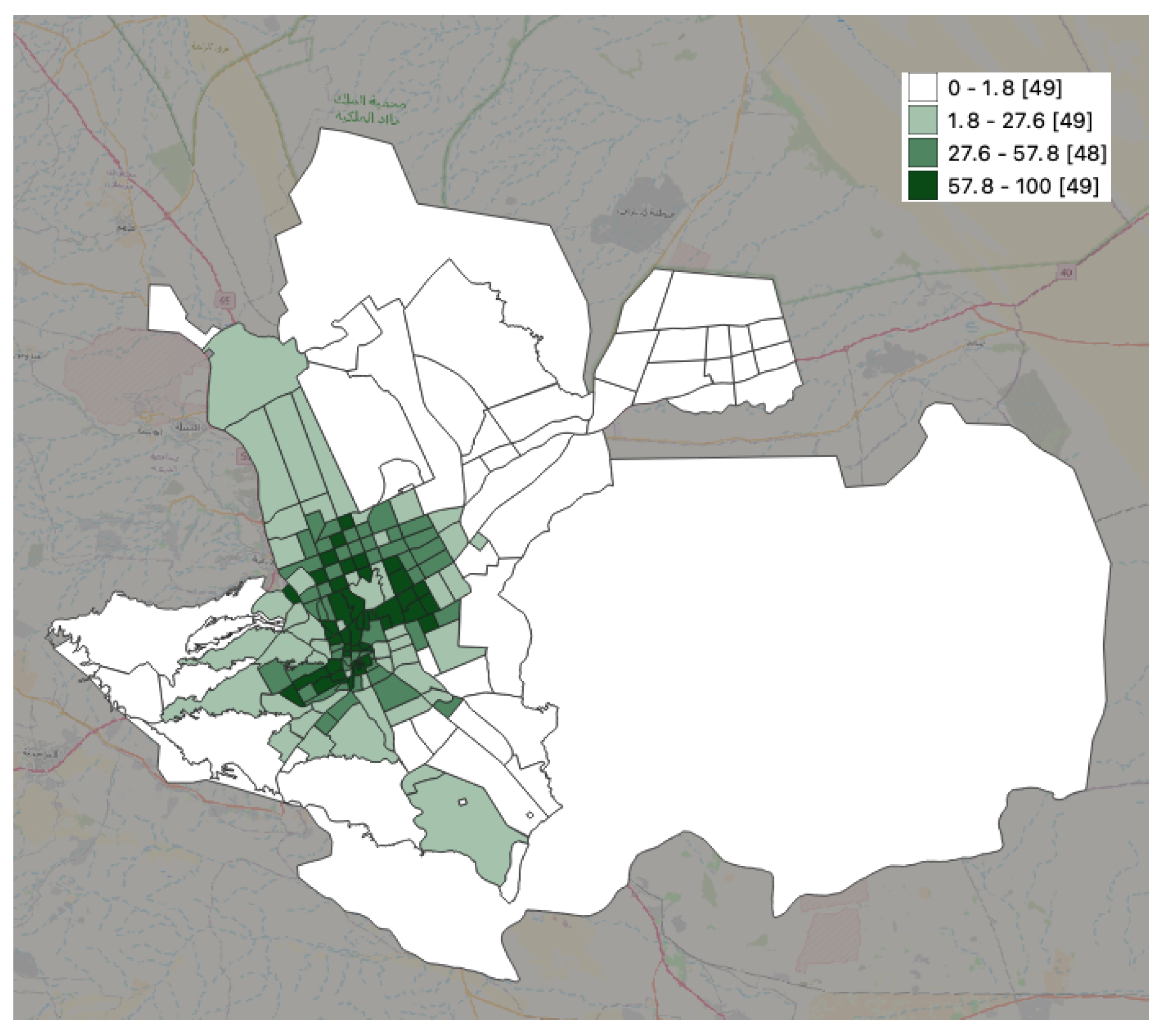
In a case study in Riyadh, Saudi Arabia, the authors investigated the accessibility of green areas and parks for residents in various neighborhoods and multidisciplinary zones [82]. The study determined the residents’ access to green spaces, considering their significance in promoting environmental sustainability, as outlined in the country’s Vision 2030. Our analysis revealed complex interdependencies among urban factors, including population density, park area size, and the number of parks. The findings indicated that some neighborhoods and municipalities have significant gaps in park access for the majority of their residents. However, municipalities with higher population densities had greater access to parks. Figure 2 shows an example of Riyadh city and its neighborhood rate of accessibility of parks and areas covered.

4.4. Disaster Response and Management

In [83], the authors focused on a case study in New York City; it included events such as Hurricane Sandy. The research proposes a novel method for crowdsourcing incident information for disaster response by utilizing publicly available data sources in smart cities. It basically focused on the X platform during the emergency cases. The method adopted the latent Dirichlet allocation (LDA) model, which basically used an unsupervised learning tool that facilitated the classification of these posts (s) by incident types without the need for data preparation, which classifies the related spatial locations. The results of the study show that the latent Dirichlet allocation (LDA) method could efficiently have high spatial calcification accuracy through the posts related to emergency incidents.
Kim and Shahabi [84] focused on improving disaster response by leveraging mobile video data gathered by crowdsourcing. The case study involved an area of Los Angeles, California. One major challenge the proposed framework focused on is prioritizing the visual data for any action that can be done during these emergencies. The proposed framework introduces a novel method for gathering and analyzing videos, which uses spatial metadata for the current situations and awareness. Here, the metadata are uploaded before the video content to speed up the analysis processing and decision-making in cases where the communication infrastructures might affected or damaged. Therefore, this approach shows a pentagonal use for decision-making in emergency cases or data, where crowdsourced mobile video data help significantly in these critical situations.
Many case studies highlight the use of crowdsourcing and spatial data analysis in disaster response and management [54,85,86].

4.5. Traffic Congestion Analysis and Transportation

4.5.1. Traffic Analysis with Crowdsourced Data

This section specifically addresses the utilization of crowdsourced data for the analysis of traffic patterns, congestion points, and commuter behavior. It examines case studies that demonstrate the efficacy of utilizing real-time data from diverse sources such as social media, GPS data, and community inputs to identify traffic patterns and areas of concern.
In this study, Ref. [87] utilizes crowdsourcing smartphone-based traffic data to perform a technical analysis of the influence of various weather conditions on traffic dynamics. The case study was conducted in Boulder-Longmont, Colorado. The analysis involves crucial traffic parameters, including volume, speed, trip length, and duration, in different weather situations such as clear, wet, and snowy scenarios. The study offers a comprehensive perspective on the impact of bad weather conditions on road traffic flow and driver decision-making by quantifying these characteristics. Utilizing this technological data, the research categorizes traffic patterns based on various weather conditions. This methodology enables a sophisticated comprehension of the correlation between meteorological conditions and fluctuations in traffic behavior. The results are crucial for the formulation of traffic control plans and improving road safety in various weather conditions, providing vital knowledge for urban planners and transportation authorities.
The study conducted in [88] examines the occurrence of traffic congestion in Manhattan, New York City, during the COVID-19 epidemic by utilizing Google traffic data. This study analyses the effects of social distancing measures by comparing traffic volumes prior to and following their introduction. The system utilizes image processing techniques to classify traffic congestion and applies generalized additive models (GAM) and seasonal decomposition of time series by LOESS (STL) to evaluate the data. The results demonstrate a notable reduction in traffic subsequent to the implementation of social distancing measures, indicating an early adherence to the restrictions. Prior to the release of lockdown orders, there was a noticeable rise in traffic, indicating a potential early onset of social-distancing tiredness. The data further demonstrate shifts in everyday traffic patterns, since the epidemic led to modifications in the typical rush hour congestion. The study’s findings indicate that crowdsourced traffic data can accurately assess human mobility and adherence to social-distancing measures. This information can offer valuable insights for future responses to pandemics and actions for traffic management.
Reference [89] proposes an innovative method for improving bicycle safety in urban environments by utilizing crowdsourcing. The SimRa platform was introduced by the authors as a smartphone-based system that employs GPS tracking and motion sensors to gather data on bicycle routes and near-miss situations. Cyclists can actively participate in the platform by providing annotations and sharing their rides in an anonymized manner. The data collected from the crowd is subsequently evaluated to detect possible areas of high risk in bicycle traffic. The study is especially pertinent to urban environments, such as cities like Berlin, where the SimRa platform has been deployed. The project utilizes crowdsourcing data to derive significant insights for identifying hazardous sections in bicycle traffic. This methodology improves cycling safety by identifying locations with a higher probability of near-miss occurrences, thereby assisting with the planning and development of urban infrastructure to create safer cycling environments.

4.5.2. Traffic Management with Crowdsourced Data

This section examines the utilization of crowdsourced data for traffic management, highlighting diverse research endeavors that tackle different aspects of this field. The papers included in this collection showcase innovative methods, ranging from improving urban navigation through the study of real-time data to improving traffic signal management by utilizing crowdsourced delay information. Every study offers distinct perspectives on how crowdsourced data could be used effectively to improve traffic flow, alleviate congestion, and bolster intelligent urban transportation systems.
Ref. [8] explores the utilization of mobile crowdsourcing to enhance real-time navigation in urban traffic. The strategy integrates data from several sensors and mobile devices to address routing issues through the utilization of integer linear programming (ILP) models and iterative methodologies. This methodology takes into consideration the presence of uncertainties and inaccuracies in the data in order to guarantee navigation solutions that are both efficient and dependable. This study is relevant to intricate urban traffic networks, where up-to-the-minute data are crucial for effectively controlling traffic flow and minimizing congestion. The study was conducted in Manhattan, New York. The methodology aims to enhance the efficiency of real-time route planning in urban settings by leveraging data from diverse sensors and mobile devices. The authors suggest employing integer linear programming (ILP) models and iterative methods to address real-time routing difficulties. In addition, they take into account uncertainties and inaccurate data inputs to guarantee dependable and effective navigation. The techniques can be used in complex urban traffic networks where the collection and analysis of real-time data are vital for traffic management and congestion reduction. This work is notable for its utilization of crowdsourced data and sophisticated computational methods applied to tackle the ever-changing traffic issues in urban areas. The findings indicate that the crowdsourcing-based navigation system outperforms traditional approaches by effectively choosing less congested routes and avoiding blocked streets. The research demonstrates the efficacy of employing crowdsourced data in real-time navigation, highlighting its capacity to enhance traffic flow and alleviate congestion in urban settings.
Reference [90] presents a technique for controlling traffic signals by utilizing real-time information gathered from mobile devices. This novel method collects real-time delay data from commuters and uses it to optimize the duration of green lights at traffic signals. The methodology is specifically designed to be economically efficient and flexible, making it particularly ideal for urban locations with diverse traffic circumstances, where conventional sensor-based systems may not be feasible or too costly. The efficacy of this system was proved by studies conducted in Thane and Noida, India, and Bandung, Indonesia, where they successfully mitigated traffic delays to a large extent. The findings underscore the potential of utilizing crowdsourced data in traffic management, demonstrating its capacity to enhance traffic flow and alleviate congestion in various urban environments. The study offers valuable insights into optimizing traffic signal regulation and highlights the benefits of utilizing technology and community data in urban planning and administration.
In [10], a framework known as (vehicular crowdsourcing for congestion support) VACCS is proposed; it is intended to utilize the computational capabilities of cars in urban traffic congestion scenarios. The objective of this method is to help transportation agencies mitigate or disperse congestion by implementing extensive signal re-timing. VACCS is notable for its utilization of on-board computational resources, such as smartphones and other IoT devices, in vehicles that are trapped in traffic. This allows the development of enhanced signal timing plans, leading to improved traffic flow and a decrease in carbon emissions. The methodology entails the creation of strategies for establishing and overseeing the process of vehicular crowdsourcing, as well as the development of theoretical models for predicting and determining the availability of resources in a dynamic manner. VACCS allows traffic signals to be more adaptive to current conditions rather than depending exclusively on past traffic volume counts. This method offers direct advantages to drivers and the smart city by improving traffic conditions, reducing driving time, and lowering fuel consumption expenses. The paper’s contribution is to address the disparity between the requirements at the municipal level and the challenges associated with the decentralized ownership of computational resources. The VACCS framework promises a revolutionary approach to computing by combining the Internet IoT with vehicular crowdsourcing to optimize the timing of signals. This method has the potential to greatly influence smart city applications, improving the management of traffic and the quality of urban living.

4.5.3. Public Transportation

The convergence of crowdsourced data with public transportation accessibility is an emerging area of study, providing revolutionary insights into urban mobility. We begin by examining examples of studies that utilize geographic information system (GIS) and general transit feed specification (GTFS) data. These analyses reveal significant differences and changes over time regarding the accessibility of public transportation, emphasizing the need for customized, data-based strategies to improve urban transportation systems and guarantee fair distribution of resources.
In [7], the authors focus on Melbourne, Australia’s public transport system. The authors present a novel framework for assessing the effectiveness and efficiency of public transport in residential regions and investigate its suitability across various local government areas (LGAs). The method uses a geographic information system (GIS) to examine accessibility based on factors such as coverage, road usage, frequency, and availability of public transportation services such as buses, trams, and trains. The key findings reveal that accessibility varies depending on population density and geographical location. Specifically, places with high population density have fewer areas without access to public transport, sometimes referred to as ’blank spots’. The survey also revealed discrepancies in the accessibility of public transportation services at various times of the day and week. In summary, the research emphasizes the necessity for enhanced accessibility to public transportation in locations with lower population density and proposes prospective avenues for future improvement.
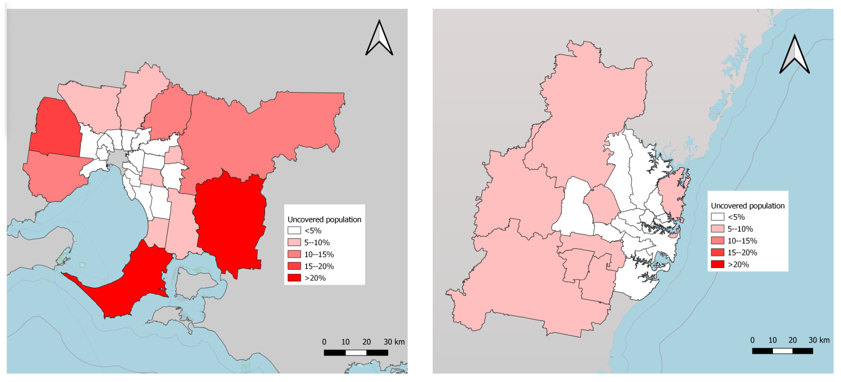
Reference [91] presents a comparative analysis of the accessibility of public transportation in Melbourne and Sydney, Australia. The system utilizes a geographic information system (GIS) to evaluate the accessibility of public transportation based on multiple criteria, such as the distribution of areas with no coverage, the distribution of population without access, and the variations in access based on time and frequency. According to the study, the proximity to city centers and the dimensions of local government areas (LGAs) have an impact on residents’ accessibility to public transportation. Although Sydney has a smaller number of areas with poor coverage and greater overall network coverage, Melbourne provides a more reliable connection independent of population density or distance from the city center. The analysis demonstrates substantial disparities in public transport accessibility both within and among these cities, underscoring the necessity for customized strategies to enhance public transport systems in diverse urban regions (see Figure 3).
Reference [92] examines the public transportation system in Szczecin, Poland. This study focuses on the temporal dimension of public transportation accessibility and its correlation with geographical fairness. The study evaluates the accessibility of public transportation in different locations of the city at various times of the day by utilizing comprehensive general transit feed specification (GTFS) data and conducting GIS analysis. It exposes notable discrepancies in accessibility, especially during non-peak hours, such as overnight, disproportionately impacting the least accessible regions. The results emphasize the significance of taking into account temporal fluctuations in accessibility in order to gain a more thorough understanding of and tackle urban transport equality.
In addition, we present three case studies that illustrate the integration of technology and crowdsourcing to improve metropolitan public transit and emergency response systems. Their research focuses on the analysis of real-time data processing in public transportation, the accuracy of vehicle tracking utilizing smartphone GPS data, and the efficient utilization of social media during emergency scenarios. Every paper offers a different perspective on the leveraging of digital tools to improve municipal infrastructure and services.
Reference [93] examines the MOBANA architecture, which is designed to integrate and process diverse public transit data. The project aims to provide effective, adaptable, and immediate data processing and visualization for public transit networks. By employing distributed messaging systems and stream processing engines, MOBANA efficiently handles the real-time tracking of vehicle positions, the integration of social media data for event detection, and the minimization of data duplication. The framework undergoes testing in Pavia, Italy, revealing its ability to improve the monitoring and analysis of public transportation.
Reference [94] examines a technique used to improve the precision of public transport vehicle placement by utilizing GPS data collected from smartphones through crowdsourcing. The study presents an enhanced particle filter technique that analyses GPS data from many passengers inside a transit vehicle. The aim of this technology is to offer more precise vehicle location in comparison to existing systems, particularly in regions where conventional car positioning infrastructure is absent. The algorithm’s efficacy is confirmed by analyzing data gathered from diverse bus routes in urban and suburban Mumbai, India. The findings indicate a notable decrease in the average placement error, demonstrating the capacity of crowdsourcing to improve public transit systems.
Reference [83] introduces a novel method for leveraging crowdsourcing social media data, specifically from Twitter, to enhance emergency response in metropolitan areas. The study uses the latent Dirichlet allocation (LDA) model to categorize tweets linked to incidents and determine the sorts of incidents that occur during emergencies. This strategy is validated using data from two major occurrences in New York City: the Chelsea explosion and Hurricane Sandy. The results demonstrate the effectiveness of the LDA model in extracting and classifying emergency-related information from social media. This provides a quick and efficient tool for emergency responses in smart cities.

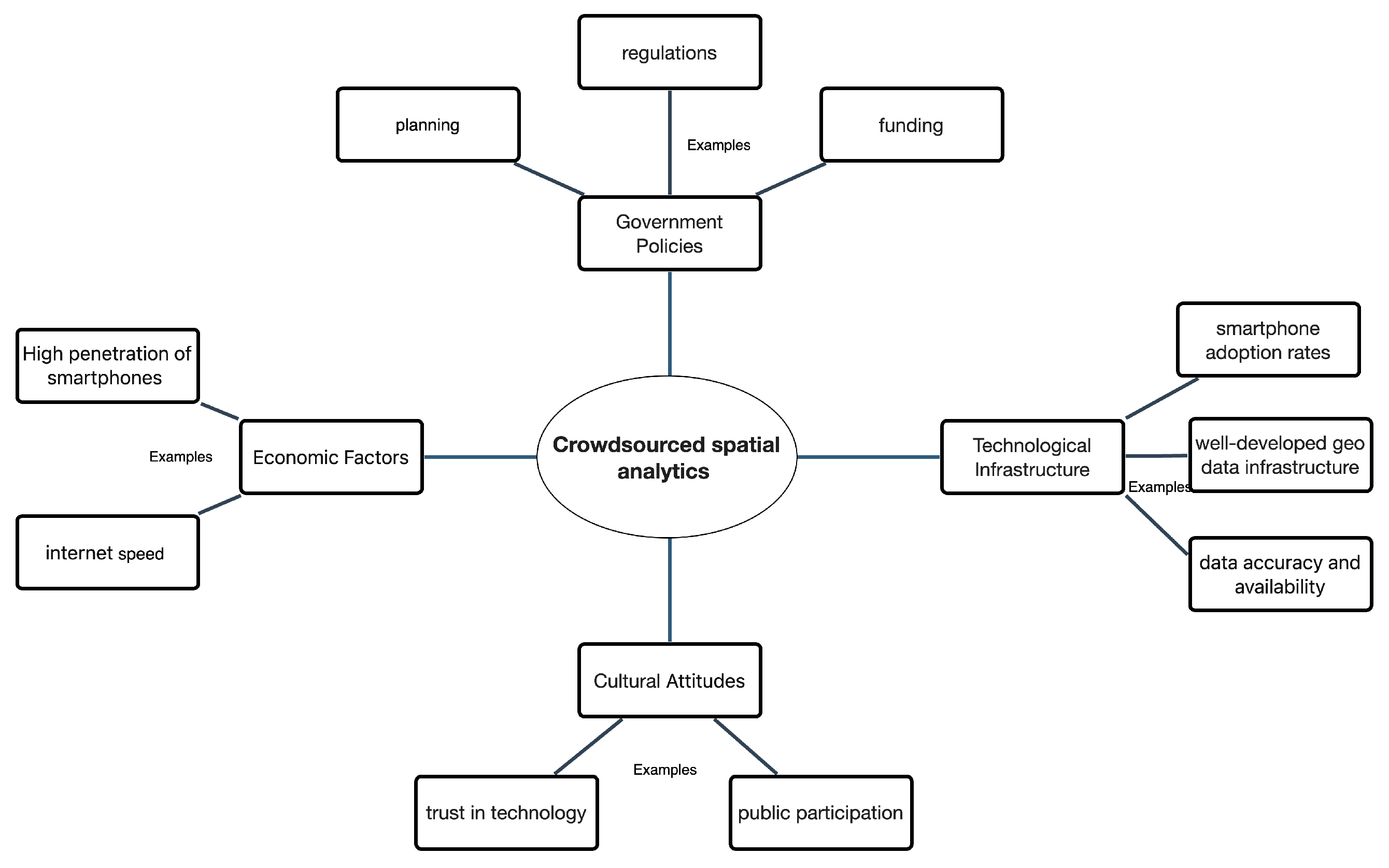
5. Challenges: Limitations and Future Trends

This section examines the complexities and challenges associated with crowdsourced spatial analytics. The issues include data quality, participant biases, privacy concerns, and technological obstacles. Through the analysis of these subjects, our objective is to offer a thorough comprehension of the challenges encountered in crowdsourced geospatial initiatives and suggest possible approaches to surmount these difficulties.
By means of crowdsourced spatial analytics, rich, varied geospatial data can be collected that offers in-depth insights into our environment. However, in order to harness the full potential of this technology, serious issues concerning data accuracy and quality must be addressed. Because participation in the crowdsourcing process is voluntary, and because there may be a prevalence of particular demographics or interests, the data can be affected by prejudices, leading to invalid conclusions. Human error and technological constraints may lead to inaccuracies in, for example, GPS data [95,96]. Also, entities with malicious intent may purposefully insert false information, further jeopardizing the integrity of the data. Verification of the obtained data poses another problem [96,97]. It is difficult to verify the accuracy of large, widely distributed databases, especially when there is no reliable ground truth data. Crowdsourced data tends to be subjective as it frequently includes opinions and impressions. This adds an additional level of complexity that makes it difficult to define and benchmark “correctness”. It is just not feasible to manually verify every data point; hence, the necessity of developing effective and efficient verification techniques [96].
Because crowdsourced data are heterogeneous, the integration and analysis of the data present several unique challenges. The diverse range of formats, various amounts of detail, and inconsistent data quality make it difficult to merge the data, find patterns, and draw valid conclusions. Also, spatial and temporal inconsistencies produce more difficulties, as data gathered at specific moments or locations may vary due to the data collection technique or the context, making it difficult to use for comparison purposes [83,92]. Often, sophisticated statistical and machine-learning methods are required to address these difficulties, and these can be computationally costly. Apart from technical challenges, there are ethical issues that must be considered [12]. The data obtained through crowdsourcing often contain personal information that must be handled ethically in terms of its collection, storage, and utilization to safeguard individuals’ privacy. Also, biases in the data can produce unjust or discriminatory results, indicating the need to consider all possible ethical consequences throughout the entire data collection and analysis process. Transparency and accountability are crucial, as they will enable users to make well-informed decisions based on the data source, its reliability, and the constraints of the data they engage with [98].
Apart from the issues associated with ethical behavior and data quality, the technology infrastructure can also pose problems. The acquisition of precise data can be hampered by expensive hardware and software that may not be available to a wide range of users, thereby preventing inclusiveness. Also, the efficient storage and management of large and heterogeneous datasets require a dependable infrastructure, effective tools, and strict quality control, although these increase the analytical complexity [98]. A comprehensive analysis of these diverse datasets requires substantial computer capacity and advanced technologies, placing an additional burden on resources. The complexities of data management and analysis make it difficult to implement real-time applications with low latency and effective data integration. Furthermore, because platforms are not uniform, this makes it difficult to exchange, reuse, and integrate data, thereby making it difficult to amalgamate information in order to conduct a thorough analysis. Ultimately, it is essential that strong security measures and procedures be implemented to prioritize privacy and safeguard the contributors and their data. However, this will add more complexity to the technical infrastructure [99]. In order to fully exploit the potential of crowdsourced spatial analytics, these technological obstacles must be successfully addressed.
Furthermore, although numerous technological issues need to be addressed, crowdsourcing spatial analytics generally poses challenges beyond those associated with data and technology. In order to ensure regular, high-quality contributions, communication must be transparent, and potential contributors require effective motivators [47]. The integration of data obtained from different platforms requires specific formats and compatible technology. Also, innovative methodologies need to be applied to ensure that contributors are proficient in the use of technology and that no obstacles arise due to language or cultural differences. To reduce algorithmic prejudice and eliminate legal difficulties, meticulous preparation and ethical deliberation are essential. Ultimately, long-term success will depend on consistent and ongoing funding, the application of effective strategies for data management, and maintaining contact and involvement with the community of contributors. Only when issues related to data, technology, and wider societal factors are addressed effectively can the potential of crowdsourced spatial analytics be harnessed as a reliable and credible source of valuable information.
By taking measures to address the shortcomings of the current technology, and adopting innovative approaches, the transformative power of crowdsourced data can be more fully exploited across various industries and sectors, guiding future directions. Below, we conduct a close examination of several cases, showing the potential of crowdsourced spatial analytics.
Crowdsourced spatial analytics and local insights present unprecedented possibilities for close observation and quick response to events captured in real time. This approach enables the collection of finely detailed data at the micro level, making it possible to accurately monitor environmental changes, traffic movements, and public sentiment. Moreover, because data are gathered via community input, stakeholders are given instant access to accurate location-centric information, thereby improving decision-making related to areas such as environmental protection, emergency management, and urban development. This application of real-time, location-based data analysis has revolutionized our understanding of and interaction with our social and natural environments and is a pivotal point in the field of spatial analytics.
Moreover, crowdsourced data have become an essential tool for lreal-time environmental and climatic monitoring. For instance, farmers are now able to obtain real-time soil moisture data from nearby fields to adjust their irrigation and conserve water. Similarly, local governments can monitor deforestation in real-time to promptly identify illegal logging, and take timely action. Crowdsourced data, combined with meteorological models and satellite imaging, can greatly improve the early warning systems used to signal the advent of natural disasters, giving communities and local authorities the time to prepare for the event [83,100]. Communities now have more access to environmental data that can be used to design proactive strategies and increase their resilience against various extreme climatic conditions.
Communities. Major issues related to healthcare, infrastructural deficits, and food safety and supply can be addressed by utilizing crowdsourced geographical data. Because this approach is based on collective efforts and accessible technology, it is possible to gain accurate insights into community needs. The collection and integration of local knowledge also encourage inclusion and sustainability in decision-making processes as it offers a more comprehensive, culturally-nuanced viewpoint on resource management and conservation [96,100]. These initiatives demonstrate that crowdsourced spatial analytics could change the nature of environmental stewardship and social justice, acting as a catalyst for resilience and community-driven change.
Furthermore, expanding our knowledge and comprehension with cutting-edge AI methods. The integration of advanced AI techniques such as explainable AI, interpretative models, federated learning, and graph neural networks has led to a significant evolution of crowdsourced geographical data analysis. If AI is explained clearly, the algorithms’ complicated decision-making process will be demystified, subsequently promoting openness and confidence among stakeholders. Federated learning enables data analysis to be decentralized while maintaining the integrity of each individual’s data, thereby helping to dispel privacy concerns. Moreover, graph neural networks can improve the richness and accuracy of insights obtained from crowdsourced data, as they provide an advanced method of understanding and simulating the complex patterns and relationships found in spatial data.
Additionally, AI can be applied to improve the quality and reliability of data through verification. This approach supports the crowdsourced data verification process, serving as the second pillar of innovation. Active learning algorithms, one technique used in this context, help simplify data labeling by identifying the most valuable instances for human annotation, thereby maximizing model training efficiency. Hybrid systems offer a balanced approach to data verification by integrating human expertise with the computational power of AI, ensuring that both scale and nuance are taken into account. Furthermore, generative adversarial networks (GANs) are utilized to detect and eliminate fake data, aiming to ensure the accuracy and reliability of crowdsourced datasets [96].
Moreover, ethical principles must be taken into consideration when developing and applying spatial data analysis. Hence, every stage of the AI lifecycle from development to application must conform stringently to the principles of justice, accountability, and transparency. The AI industry’s commitment to ethical standards is evident in its attempts to foster diversity, minimize algorithmic prejudice, and develop AI governance frameworks that encourage and enable. Furthermore, ready access to spatial data analytics, the focus on developing systems that are multilingual and culturally sensitive, and giving non-expert users access to AI tools via low-code/no-code platforms will lead to a more inclusive and equitable technological future [101].
Combining historical, sensor, and satellite imagery with crowdsourced geographical data multi-dimensional spatial data cubes facilitates a thorough analysis of data that yields patterns and predicts trends, enabling better resource management. The geographically distributed processing offered by edge computing facilitates real-time, locally-focused solutions for specific environmental and infrastructure problems related to noise pollution, air quality, and traffic management, for example. Hence, communities can obtain useful and actionable information enabling them to solve or mitigate problems in their local area.
Finally, a better understanding of ecological and cultural complexities can be obtained by combining native wisdom and regional knowledge and expertise with crowdsourcing data interdisciplinary [58]. The integration of behavioral analysis and social science theories and insights can improve the strategies applied to encourage community engagement, increase participation, and improve data quality. Partnerships between various fields such as public health, urban planning, and economics use crowdsourced spatial data to creatively address global issues. Hence, multidisciplinary activities are essential since they can increase the influence and inclusivity of geographical data.

6. Conclusions

This paper investigates the area of crowdsourced and spatial data analytics from several perspectives. It explores how new technologies, such as AI and cloud-based GIS, can improve the quality of geospatial data that can assist society in many ways. In order to ensure the reliable and safe integration of crowdsourced data with spatial analytics, the paper also highlights important methodological developments that address privacy and security issues. Using several case studies of cities around the world, the research shows the influence of crowdsourcing data in several fields, such as traffic congestion analysis and transportation, environmental monitoring, urban planning, and health. The importance of crowdsourced spatial analytics for well-informed policy and decision-making has been shown in these case studies. This paper discusses the limitations and challenges that researchers face today in the context of crowdsourced data and spatial data analytics, predicting a future where there will be more collaboration and convergence between the expanding availability of high-quality crowdsourced data and technological and methodological breakthroughs.

Funding

This research received no external funding.

Data Availability Statement

The data presented in this study are available on request from the corresponding author.

Conflicts of Interest

The author declares no conflict of interest.

References

  1. Breunig, M.; Bradley, P.E.; Jahn, M.; Kuper, P.; Mazroob, N.; Rösch, N.; Al-Doori, M.; Stefanakis, E.; Jadidi, M. Geospatial data management research: Progress and future directions. ISPRS Int. J. Geo-Inf. 2020, 9, 95. [Google Scholar] [CrossRef]
  2. Lee, J.G.; Kang, M. Geospatial Big Data: Challenges and Opportunities. Big Data Res. 2015, 2, 74–81. [Google Scholar] [CrossRef]
  3. Das, J.; Ghosh, S.K.; Buyya, R. Geospatial edge-fog computing: A systematic review, taxonomy, and future directions. Mob. Edge Comput. 2021, 47–69. [Google Scholar]
  4. Niu, H.; Silva, E.A. Crowdsourced data mining for urban activity: Review of data sources, applications, and methods. J. Urban Plan. Dev. 2020, 146, 04020007. [Google Scholar] [CrossRef]
  5. Srivastava, P.; Mostafavi, A. Challenges and opportunities of crowdsourcing and participatory planning in developing infrastructure systems of smart cities. Infrastructures 2018, 3, 51. [Google Scholar] [CrossRef]
  6. Wu, H.; Gui, Z.; Yang, Z. Geospatial big data for urban planning and urban management. Geo-Spat. Inf. Sci. 2020, 23, 273–274. [Google Scholar] [CrossRef]
  7. Alamri, S.; Adhinugraha, K.; Allheeib, N.; Taniar, D. GIS Analysis of Adequate Accessibility to Public Transportation in Metropolitan Areas. ISPRS Int. J. Geo-Inf. 2023, 12, 180. [Google Scholar] [CrossRef]
  8. Wan, X.; Ghazzai, H.; Massoud, Y. Mobile crowdsourcing for intelligent transportation systems: Real-time navigation in urban areas. IEEE Access 2019, 7, 136995–137009. [Google Scholar] [CrossRef]
  9. Song, W.; Wu, C. Introduction to advancements of GIS in the new IT era. Ann. Gis 2021, 27, 1–4. [Google Scholar] [CrossRef]
  10. Olariu, S. Vehicular crowdsourcing for congestion support in smart cities. Smart Cities 2021, 4, 662–685. [Google Scholar] [CrossRef]
  11. Bhat, M.A.; Shah, R.M.; Ahmad, B. A solution to Geographical Information Systems(GIS). Int. J. Comput. Sci. Eng. 2011, 3, 594–600. [Google Scholar]
  12. Kiwelekar, A.W.; Mahamunkar, G.S.; Netak, L.D.; Nikam, V.B. Deep Learning Techniques for Geospatial Data Analysis. In Machine Learning Paradigms: Advances in Deep Learning-Based Technological Applications; Tsihrintzis, G.A., Jain, L.C., Eds.; Springer International Publishing: Cham, Switzerland, 2020; pp. 63–81. [Google Scholar] [CrossRef]
  13. Mapbox. Assessing Satellite Imagery at Scale: How We’re Mapping the Quality of Our Satellite and Aerial Tiles; Mapbox: San Francisco, CA, USA, 2018. [Google Scholar]
  14. Wang, S.; Cao, J.; Yu, P.S. Deep Learning for Spatio-Temporal Data Mining: A Survey. IEEE Trans. Knowl. Data Eng. 2022, 34, 3681–3700. [Google Scholar] [CrossRef]
  15. Liu, S.; Wang, L.; Zhang, W.; He, Y.; Pijush, S. A comprehensive review of machine learning-based methods in landslide susceptibility mapping. Geol. J. 2023, 58, 2283–2301. [Google Scholar] [CrossRef]
  16. Teixeira, T.A.; Vilaça, N.L.; Printes, A.L.; Gomes, R.C.S.; Torné, I.G.; Araújo, T.Y.A.; Dias, A.G.D.e. Development of a Monitoring System against Illegal Deforestation in the Amazon Rainforest Using Artificial Intelligence Algorithms. Eng. Proc. 2023, 58, 21. [Google Scholar] [CrossRef]
  17. Janowicz, K.; Gao, S.; McKenzie, G.; Hu, Y.; Bhaduri, B. GeoAI: Spatially explicit artificial intelligence techniques for geographic knowledge discovery and beyond. Int. J. Geogr. Inf. Sci. 2020, 34, 625–636. [Google Scholar] [CrossRef]
  18. Bern Szukalski, M.B. Mapping the Future of GIS. 2018. Available online: https://www.esri.com/about/newsroom/blog/mapping-future-gis/ (accessed on 1 May 2024).
  19. GeoServer. GeoServer: Open Source Server for Geospatial Data. 2024. Available online: https://geoserver.org/ (accessed on 18 December 2023).
  20. Kumar, L.; Mutanga, O. Google Earth Engine Applications Since Inception: Usage, Trends, and Potential. Remote Sens. 2018, 10, 1509. [Google Scholar] [CrossRef]
  21. Mete, M.O.; Yomralioglu, T. Implementation of serverless cloud GIS platform for land valuation. Int. J. Digit. Earth 2021, 14, 836–850. [Google Scholar] [CrossRef]
  22. Pakdil, M.E.; Çelik, R.N. Serverless geospatial data processing workflow system design. ISPRS Int. J. Geo-Inf. 2022, 11, 20. [Google Scholar] [CrossRef]
  23. Bebortta, S.; Das, S.K.; Kandpal, M.; Barik, R.K.; Dubey, H. Geospatial serverless computing: Architectures, tools and future directions. ISPRS Int. J. Geo-Inf. 2020, 9, 311. [Google Scholar] [CrossRef]
  24. Wu, B.; Tian, F.; Zhang, M.; Zeng, H.; Zeng, Y. Cloud services with big data provide a solution for monitoring and tracking sustainable development goals. Geogr. Sustain. 2020, 1, 25–32. [Google Scholar] [CrossRef]
  25. Guo, W.; Chang, Z.; Su, Y.; Guo, X.; Hämäläinen, T.; Li, J.; Li, Y. Reputation-Based Blockchain for Spatial Crowdsourcing in Vehicular Networks. Appl. Sci. 2022, 12, 11049. [Google Scholar] [CrossRef]
  26. Gong, Z.; Li, J.; Lin, Y.; Yuan, L.; Gao, W. A novel dual cloud server privacy-preserving scheme in spatial crowdsourcing. Comput. Secur. 2024, 138, 103659. [Google Scholar] [CrossRef]
  27. Sunkara, V.; Purri, M.; Saux, B.L.; Adams, J. Street to cloud: Improving flood maps with crowdsourcing and semantic segmentation. arXiv 2020, arXiv:2011.08010. [Google Scholar]
  28. Miao, Y.; Yang, Y.; Li, X.; Wei, L.; Liu, Z.; Deng, R.H. Efficient privacy-preserving spatial data query in cloud computing. IEEE Trans. Knowl. Data Eng. 2023, 36, 122–136. [Google Scholar] [CrossRef]
  29. Li, Y.; Xie, J.; Jiang, R.; Yan, D. Application of edge computing and GIS in ecological water requirement prediction and optimal allocation of water resources in irrigation area. PLoS ONE 2021, 16, e0254547. [Google Scholar] [CrossRef] [PubMed]
  30. Zhang, J.; Ma, B.; Huang, J. Deploying GIS services into the edge: A study from performance evaluation and optimization viewpoint. Secur. Commun. Netw. 2020, 2020, 8822990. [Google Scholar] [CrossRef]
  31. Cao, X.; Madria, S. Efficient geospatial data collection in iot networks for mobile edge computing. In Proceedings of the 2019 IEEE 18th International Symposium on Network Computing and Applications (NCA), Cambridge, MA USA, 26–28 September 2019; pp. 1–10. [Google Scholar]
  32. Ketzler, B.; Naserentin, V.; Latino, F.; Zangelidis, C.; Thuvander, L.; Logg, A. Digital twins for cities: A state of the art review. Built Environ. 2020, 46, 547–573. [Google Scholar] [CrossRef]
  33. Uggla, M.; Olsson, P.; Abdi, B.; Axelsson, B.; Calvert, M.; Christensen, U.; Gardevärn, D.; Hirsch, G.; Jeansson, E.; Kadric, Z.; et al. Future Swedish 3D city models—Specifications, test data, and evaluation. ISPRS Int. J. Geo-Inf. 2023, 12, 47. [Google Scholar] [CrossRef]
  34. Lehtola, V.V.; Koeva, M.; Elberink, S.O.; Raposo, P.; Virtanen, J.P.; Vahdatikhaki, F.; Borsci, S. Digital twin of a city: Review of technology serving city needs. Int. J. Appl. Earth Obs. Geoinf. 2022, 114, 102915. [Google Scholar] [CrossRef]
  35. QGIS. 2023. Available online: https://www.qgis.org/en/site/ (accessed on 20 December 2023).
  36. PostGIS. 2023. Available online: https://postgis.net/ (accessed on 20 December 2023).
  37. GeoPandas. Available online: https://geopandas.org/ (accessed on 20 December 2023).
  38. Amazon Web Services (AWS)-Geospatial. 2023. Available online: https://aws.amazon.com/geospatial/ (accessed on 22 December 2023).
  39. Microsoft Azure-Azure Machine Learning. 2023. Available online: https://azure.microsoft.com/en-us/services/machine-learning/ (accessed on 22 December 2023).
  40. Microsoft Azure-Azure Maps. 2023. Available online: https://azure.microsoft.com/en-us/services/azure-maps/ (accessed on 24 December 2023).
  41. Klopfenstein, L.C.; Delpriori, S.; Polidori, P.; Sergiacomi, A.; Marcozzi, M.; Boardman, D.; Parfitt, P.; Bogliolo, A. Mobile crowdsensing for road sustainability: Exploitability of publicly-sourced data. Int. Rev. Appl. Econ. 2020, 34, 650–671. [Google Scholar] [CrossRef]
  42. Tong, Y.; Zhou, Z.; Zeng, Y.; Chen, L.; Shahabi, C. Spatial crowdsourcing: A survey. Vldb J. 2020, 29, 217–250. [Google Scholar] [CrossRef]
  43. Staniek, M. Road pavement condition diagnostics using smartphone-based data crowdsourcing in smart cities. J. Traffic Transp. Eng. (Engl. Ed.) 2021, 8, 554–567. [Google Scholar] [CrossRef]
  44. Yu, Q.; Duan, Y.; Wu, Q.; Liu, Y.; Wen, C.; Qian, J.; Song, Q.; Li, W.; Sun, J.; Wu, W. An interactive and iterative method for crop mapping through crowdsourcing optimized field samples. Int. J. Appl. Earth Obs. Geoinf. 2023, 122, 103409. [Google Scholar] [CrossRef]
  45. Haklay, M.; Weber, P. Openstreetmap: User-generated street maps. IEEE Pervasive Comput. 2008, 7, 12–18. [Google Scholar] [CrossRef]
  46. Arsanjani, J.J.; Barron, C.; Bakillah, M.; Helbich, M. Assessing the quality of OpenStreetMap contributors together with their contributions. In Proceedings of the AGILE, Nashville, TN, USA, 5–9 August 2013; pp. 14–17. [Google Scholar]
  47. Elwood, S.; Goodchild, M.F.; Sui, D.Z. Researching volunteered geographic information: Spatial data, geographic research, and new social practice. Ann. Assoc. Am. Geogr. 2012, 102, 571–590. [Google Scholar] [CrossRef]
  48. Alam, M.Y.; Nandi, A.; Kumar, A.; Saha, S.; Saha, M.; Nandi, S.; Chakraborty, S. Crowdsourcing from the True crowd: Device, vehicle, road-surface and driving independent road profiling from smartphone sensors. Pervasive Mob. Comput. 2020, 61, 101103. [Google Scholar] [CrossRef]
  49. Hu, J.; Lin, H.; Guo, X.; Yang, J. DTCS: An integrated strategy for enhancing data trustworthiness in mobile crowdsourcing. IEEE Internet Things J. 2018, 5, 4663–4671. [Google Scholar] [CrossRef]
  50. Boukerche, A.; Kantarci, B.; Kaptan, C. Towards ensuring the reliability and dependability of vehicular crowd-sensing data in GPS-less location tracking. Pervasive Mob. Comput. 2020, 68, 101248. [Google Scholar] [CrossRef]
  51. Hamrouni, A.; Ghazzai, H.; Frikha, M.; Massoud, Y. A spatial mobile crowdsourcing framework for event reporting. IEEE Trans. Comput. Soc. Syst. 2020, 7, 477–491. [Google Scholar] [CrossRef]
  52. Wu, Z.; Peng, L.; Xiang, C. Assuring quality and waiting time in real-time spatial crowdsourcing. Decis. Support Syst. 2023, 164, 113869. [Google Scholar] [CrossRef]
  53. Telima, M.; El Esawey, M.; El-Basyouny, K.; Osama, A. The use of crowdsourcing data for analyzing pedestrian safety in urban areas. Ain Shams Eng. J. 2023, 14, 102140. [Google Scholar] [CrossRef]
  54. Grassi, L.; Ciranni, M.; Baglietto, P.; Recchiuto, C.T.; Maresca, M.; Sgorbissa, A. Emergency management through information crowdsourcing. Inf. Process. Manag. 2023, 60, 103386. [Google Scholar] [CrossRef]
  55. Tavra, M.; Racetin, I.; Peroš, J. The role of crowdsourcing and social media in crisis mapping: A case study of a wildfire reaching Croatian City of Split. Geoenviron. Disasters 2021, 8, 10. [Google Scholar] [CrossRef]
  56. Samulowska, M.; Chmielewski, S.; Raczko, E.; Lupa, M.; Myszkowska, D.; Zagajewski, B. Crowdsourcing without data bias: Building a quality assurance system for air pollution symptom mapping. ISPRS Int. J. Geo-Inf. 2021, 10, 46. [Google Scholar] [CrossRef]
  57. Kraft, R.; Birk, F.; Reichert, M.; Deshpande, A.; Schlee, W.; Langguth, B.; Baumeister, H.; Probst, T.; Spiliopoulou, M.; Pryss, R. Efficient processing of geospatial mhealth data using a scalable crowdsensing platform. Sensors 2020, 20, 3456. [Google Scholar] [CrossRef]
  58. Huang, X.; Song, Y.; Hu, X. Deploying spatial data for coastal community resilience: A review from the managerial perspective. Int. J. Environ. Res. Public Health 2021, 18, 830. [Google Scholar] [CrossRef] [PubMed]
  59. To, H.; Ghinita, G.; Shahabi, C. A framework for protecting worker location privacy in spatial crowdsourcing. Proc. VLDB Endow. 2014, 7, 919–930. [Google Scholar] [CrossRef]
  60. Alharthi, R.; Banihani, A.; Alzahrani, A.; Alshehri, A.; Alshahrani, H.; Fu, H.; Liu, A.; Zhu, Y. Location privacy challenges in spatial crowdsourcing. In Proceedings of the 2018 IEEE International Conference on Electro/Information Technology (EIT), Rochester, MI, USA, 3–5 May 2018; pp. 564–569. [Google Scholar]
  61. Chu, X.; Liu, J.; Gong, D.; Wang, R. Preserving location privacy in spatial crowdsourcing under quality control. IEEE Access 2019, 7, 155851–155859. [Google Scholar] [CrossRef]
  62. Ang, K.L.M.; Seng, J.K.P.; Ngharamike, E. Towards crowdsourcing internet of things (crowd-iot): Architectures, security and applications. Future Internet 2022, 14, 49. [Google Scholar] [CrossRef]
  63. Ma, Y.; Sun, Y.; Lei, Y.; Qin, N.; Lu, J. A survey of blockchain technology on security, privacy, and trust in crowdsourcing services. World Wide Web 2020, 23, 393–419. [Google Scholar] [CrossRef]
  64. Han, S.; Lin, J.; Zhao, S.; Xu, G.; Ren, S.; He, D.; Wang, L.; Shi, L. Location privacy-preserving distance computation for spatial crowdsourcing. IEEE Internet Things J. 2020, 7, 7550–7563. [Google Scholar] [CrossRef]
  65. Thuan, N.H.; Antunes, P.; Johnstone, D. Factors influencing the decision to crowdsource: A systematic literature review. Inf. Syst. Front. 2016, 18, 47–68. [Google Scholar] [CrossRef]
  66. Sores, C.M. Crowdsourced Data to Improve Municipalities Governance: Sesimbra’s Case; Universidade NOVA de Lisboa: Lisbon, Portugal, 2021. [Google Scholar]
  67. Bechtel, B.; Demuzere, M.; Sismanidis, P.; Fenner, D.; Brousse, O.; Beck, C.; Van Coillie, F.; Conrad, O.; Keramitsoglou, I.; Middel, A.; et al. Quality of crowdsourced data on urban morphology—the human influence experiment (HUMINEX). Urban Sci. 2017, 1, 15. [Google Scholar] [CrossRef]
  68. Jahn, M.W.; Bradley, P.E. Topological Access Methods for Spatial and Spatiotemporal Data. ISPRS Int. J. Geo-Inf. 2022, 11, 533. [Google Scholar] [CrossRef]
  69. Guo, F.; Schlink, U.; Wu, W.; Mohamdeen, A. Differences in Urban Morphology between 77 Cities in China and Europe. Remote Sens. 2022, 14, 5462. [Google Scholar] [CrossRef]
  70. Sumari, N.S.; Xu, G.; Ujoh, F.; Korah, P.I.; Ebohon, O.J.; Lyimo, N.N. A geospatial approach to sustainable urban planning: Lessons for Morogoro Municipal Council, Tanzania. Sustainability 2019, 11, 6508. [Google Scholar] [CrossRef]
  71. Benevides, C.C.; Ribeiro, S.R.; Falcão, A.P.; Silva, J.B.; Moura, A.C.M. The use of 3D GIS models for spatial analysis: A Case study from the city of Fortaleza, Brazil. Disegnarecon 2018, 11, 13-1. [Google Scholar]
  72. Morosini, R.; Zucaro, F. Land use and urban sustainability assessment: A 3D-GIS application to a case study in Gozo. City Territ Arch. 2019, 6, 7. [Google Scholar] [CrossRef]
  73. Luan, C.; Liu, R.; Peng, S. Land-use suitability assessment for urban development using a GIS-based soft computing approach: A case study of Ili Valley, China. Ecol. Indic. 2021, 123, 107333. [Google Scholar] [CrossRef]
  74. Shi, Y.; Liu, X.; Kok, S.Y.; Rajarethinam, J.; Liang, S.; Yap, G.; Chong, C.S.; Lee, K.S.; Tan, S.S.; Chin, C.K.Y.; et al. Three-month real-time dengue forecast models: An early warning system for outbreak alerts and policy decision support in Singapore. Environ. Health Perspect. 2016, 124, 1369–1375. [Google Scholar] [CrossRef]
  75. Bordon, Y. Targeting malaria transmission. Nat. Rev. Immunol. 2022, 22, 595. [Google Scholar] [CrossRef]
  76. Allorant, A.; Biswas, S.; Ahmed, S.; Wiens, K.; LeGrand, K.; Janko, M.; Henry, N.; Dangel, W.; Watson, A.; Blacker, B.; et al. Finding gaps in routine TB surveillance activities in Bangladesh. Int. J. Tuberc. Lung Dis. 2022, 26, 356–362. [Google Scholar] [CrossRef] [PubMed]
  77. Yang, S.; Ning, S.; Kou, S. Use internet search data to accurately track state level influenza epidemics. Sci. Rep. 2021, 11, 4023. [Google Scholar] [CrossRef] [PubMed]
  78. Lyu, W.; Seok, N.; Chen, X.; Xu, R. Using Crowdsourced Food Image Data for Assessing Restaurant Nutrition Environment: A Validation Study. Nutrients 2023, 15, 4287. [Google Scholar] [CrossRef] [PubMed]
  79. Boonnam, N.; Udomchaipitak, T.; Puttinaovarat, S.; Chaichana, T.; Boonjing, V.; Muangprathub, J. Coral Reef Bleaching under Climate Change: Prediction Modeling and Machine Learning. Sustainability 2022, 14, 6161. [Google Scholar] [CrossRef]
  80. Bhattacharyya, S.; Mondal, N.K.; Platos, J.; Snasel, V.; Kromer, P. Intelligent Environmental Data Monitoring for Pollution Management; Academic Press: Cambridge, MA, USA, 2020. [Google Scholar]
  81. Periñán-Pascual, C.; Arcas-Túnez, F. Detecting environmentally-related problems on Twitter. Biosyst. Eng. 2019, 177, 31–48. [Google Scholar] [CrossRef]
  82. Alamri, S. Spatial Analysis and GIS Mapping of Public Parks Adequacy: A Case Study from Riyadh, Saudi Arabia. Sustainability 2024, 16, 3305. [Google Scholar] [CrossRef]
  83. Zuo, F.; Kurkcu, A.; Ozbay, K.; Gao, J. Crowdsourcing incident information for emergency response using open data sources in smart cities. Transp. Res. Rec. 2018, 2672, 198–208. [Google Scholar] [CrossRef]
  84. To, H.; Kim, S.H.; Shahabi, C. Effectively crowdsourcing the acquisition and analysis of visual data for disaster response. In Proceedings of the 2015 IEEE International Conference on Big Data (Big Data), Santa Clara, CA, USA, 29 October–1 November 2015; pp. 697–706. [Google Scholar]
  85. Poblet, M.; García-Cuesta, E.; Casanovas, P. Crowdsourcing tools for disaster management: A review of platforms and methods. In International Workshop on AI Approaches to the Complexity of Legal Systems; Springer: Berlin/Heidelberg, Germany, 2013; pp. 261–274. [Google Scholar]
  86. Riccardi, M.T. The power of crowdsourcing in disaster response operations. Int. J. Disaster Risk Reduct. 2016, 20, 123–128. [Google Scholar] [CrossRef]
  87. Elyoussoufi, A.; Walker, C.L.; Black, A.W.; DeGirolamo, G.J. The Relationships between Adverse Weather, Traffic Mobility, and Driver Behavior. Meteorology 2023, 2, 489–508. [Google Scholar] [CrossRef]
  88. Shearston, J.A.; Martinez, M.E.; Nunez, Y.; Hilpert, M. Social-distancing fatigue: Evidence from real-time crowd-sourced traffic data. Sci. Total Environ. 2021, 792, 148336. [Google Scholar] [CrossRef]
  89. Karakaya, A.S.; Hasenburg, J.; Bermbach, D. SimRa: Using crowdsourcing to identify near miss hotspots in bicycle traffic. Pervasive Mob. Comput. 2020, 67, 101197. [Google Scholar] [CrossRef]
  90. Dixit, V.; Nair, D.J.; Chand, S.; Levin, M.W. A simple crowdsourced delay-based traffic signal control. PLoS ONE 2020, 15, e0230598. [Google Scholar] [CrossRef] [PubMed]
  91. Biswas, A.; Adhinugraha, K.; Taniar, D. Comparative GIS Analysis of Public Transport Accessibility in Metropolitan Areas. Computers 2023, 12, 260. [Google Scholar] [CrossRef]
  92. Stępniak, M.; Goliszek, S. Spatio-temporal variation of accessibility by public transport—The equity perspective. In The Rise of Big Spatial Data; Springer: Berlin/Heidelberg, Germany, 2017; pp. 241–261. [Google Scholar]
  93. Ma, T.; Motta, G.; Liu, K. Delivering real-time information services on public transit: A framework. IEEE Trans. Intell. Transp. Syst. 2017, 18, 2642–2656. [Google Scholar] [CrossRef]
  94. Mukheja, P.; Kiran K, M.; Velaga, N.R.; Sharmila, R. Smartphone-based crowdsourcing for position estimation of public transport vehicles. IET Intell. Transp. Syst. 2017, 11, 588–595. [Google Scholar] [CrossRef]
  95. Li, G.; Zheng, Y.; Fan, J.; Wang, J.; Cheng, R. Crowdsourced data management: Overview and challenges. In Proceedings of the 2017 ACM International Conference on Management of Data, Chicago, IL, USA, 14–19 May 2017; pp. 1711–1716. [Google Scholar]
  96. Basiri, A.; Haklay, M.; Foody, G.; Mooney, P. Crowdsourced geospatial data quality: Challenges and future directions. Int. J. Geogr. Inf. Sci. 2019, 33, 1588–1593. [Google Scholar] [CrossRef]
  97. Laso Bayas, J.C.; See, L.; Bartl, H.; Sturn, T.; Karner, M.; Fraisl, D.; Moorthy, I.; Busch, M.; van der Velde, M.; Fritz, S. Crowdsourcing LUCAS: Citizens generating reference land cover and land use data with a mobile app. Land 2020, 9, 446. [Google Scholar] [CrossRef]
  98. Sumner, J.L.; Farris, E.M.; Holman, M.R. Crowdsourcing reliable local data. Political Anal. 2020, 28, 244–262. [Google Scholar] [CrossRef]
  99. Boeing, G. The right tools for the job: The case for spatial science tool-building. Trans. GIS 2020, 24, 1299–1314. [Google Scholar] [CrossRef]
  100. Tong, Y.; Chen, L.; Shahabi, C. Spatial crowdsourcing: Challenges, techniques, and applications. Proc. VLDB Endow. 2017, 10, 1988–1991. [Google Scholar] [CrossRef]
  101. Kamrowska-Załuska, D. Impact of AI-based tools and urban big data analytics on the design and planning of cities. Land 2021, 10, 1209. [Google Scholar] [CrossRef]
Figure 1. Examples of factors that affect trends in crowdsourcing spatial data analytics.
Ijgi 13 00168 g001
Figure 2. Riyadh city and percentage park accessibility.
Ijgi 13 00168 g002
Figure 3. Melbourne and Sydney comparison of the uncovered population for public transportation [91].
Ijgi 13 00168 g003
Disclaimer/Publisher’s Note: The statements, opinions and data contained in all publications are solely those of the individual author(s) and contributor(s) and not of MDPI and/or the editor(s). MDPI and/or the editor(s) disclaim responsibility for any injury to people or property resulting from any ideas, methods, instructions or products referred to in the content.

