Multi-Criteria Framework for Routing on Access Land: A Case Study on Dartmoor National Park
Abstract
1. Introduction
Justification and Objective
- Create a routing network that is capable of routing across open access land.
- Integrate multi-criteria into the routing system to provide routes tailored for different user preferences or needs.
- Evaluate the generated routes against other routing algorithms, as well as routes recorded by real walkers.
2. Related Work
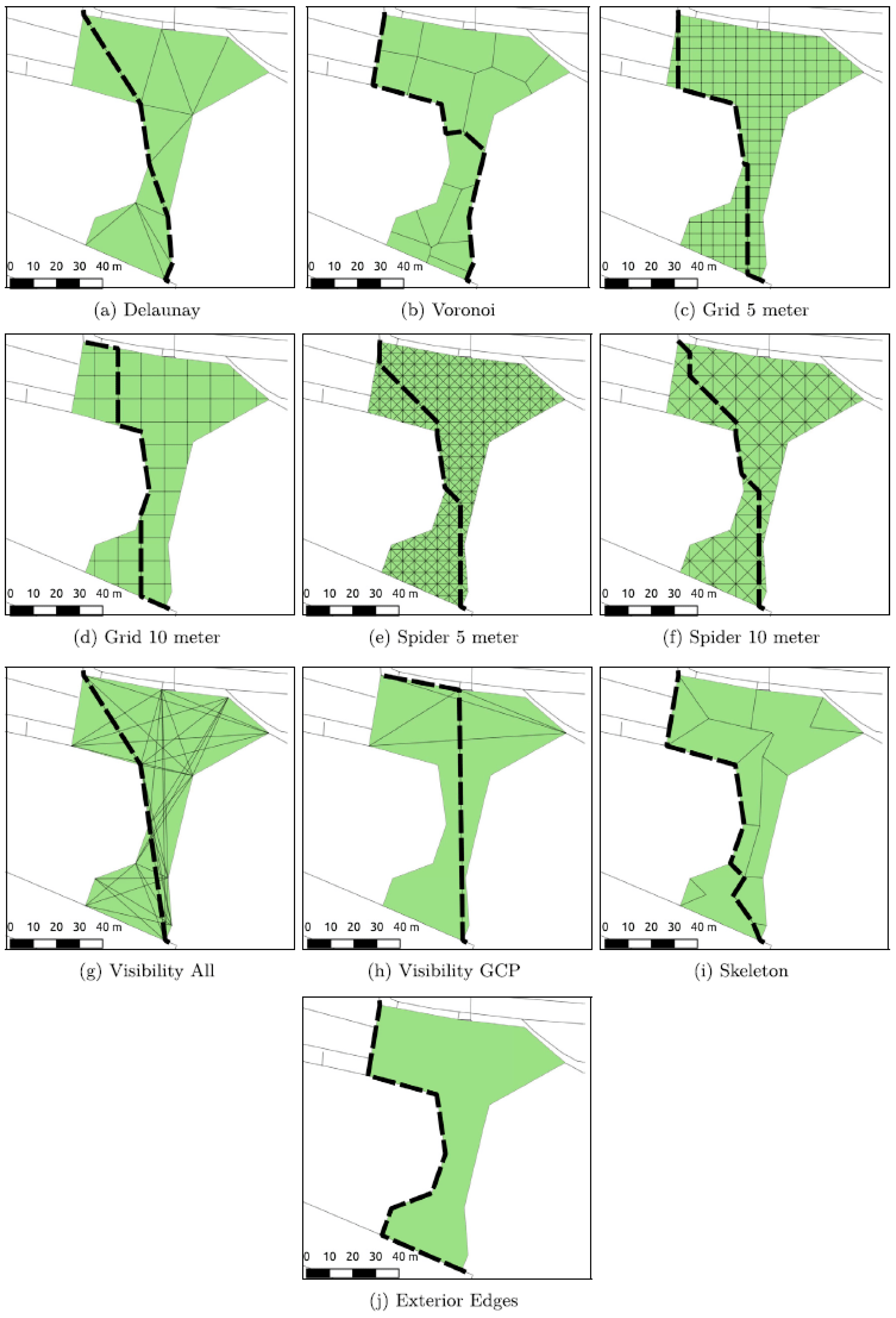
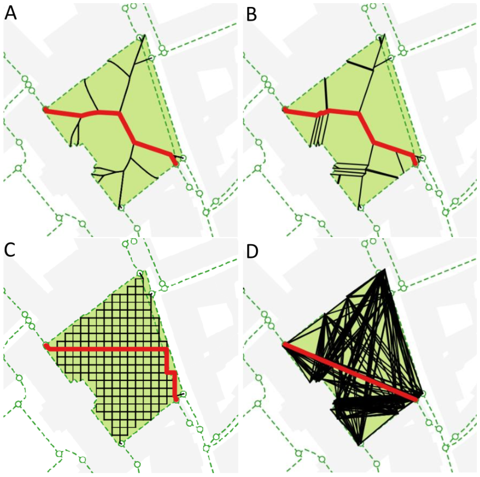
2.1. Routing through Open Areas
2.2. Multi-Criteria Routing
2.3. Gaps in Relevant Work
3. Materials and Methods
3.1. Materials
3.1.1. British National Grid
3.1.2. Detailed Path Network
3.1.3. MasterMap Topography
3.1.4. Terrain 5
3.1.5. Devon County Council Access Land and Dartmoor Commons
3.1.6. Dartmoor National Parks Authority Habitat Classification Map
3.1.7. OS Maps User Generated Routes
3.2. Methods
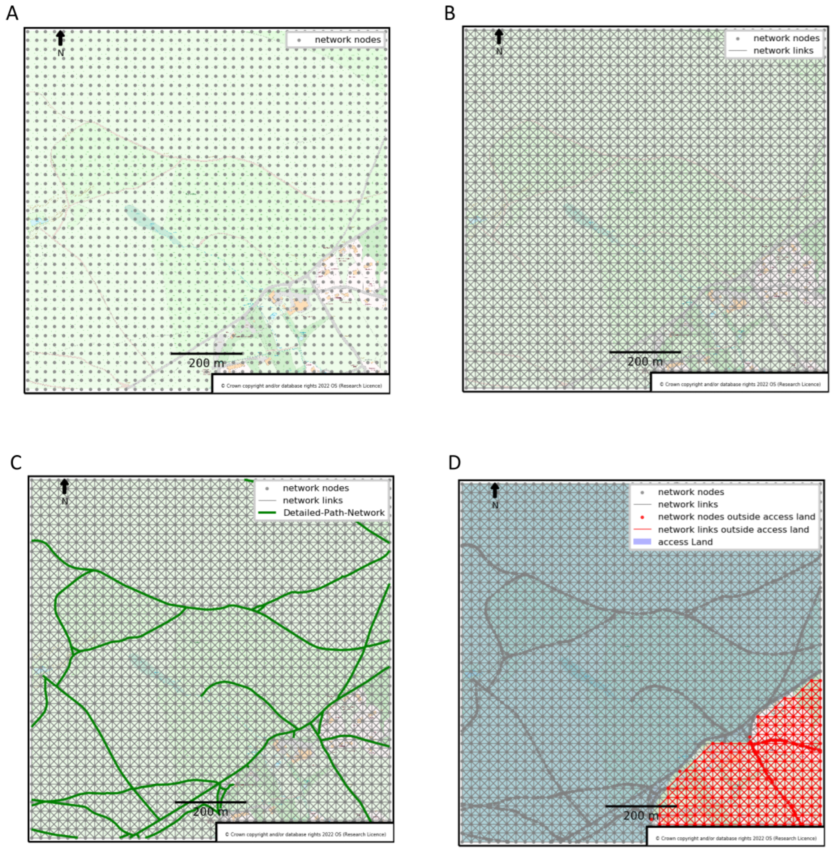
3.2.1. Creating a Spider-Grid Subgraph
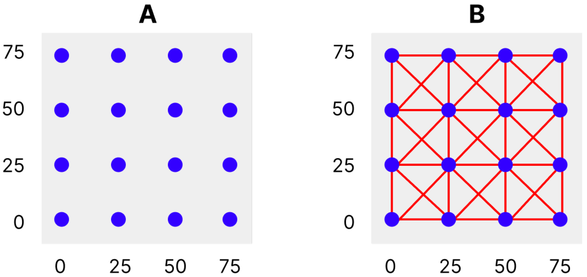
Node Creation
Link Creation
3.2.2. Enhancing the Subgraph
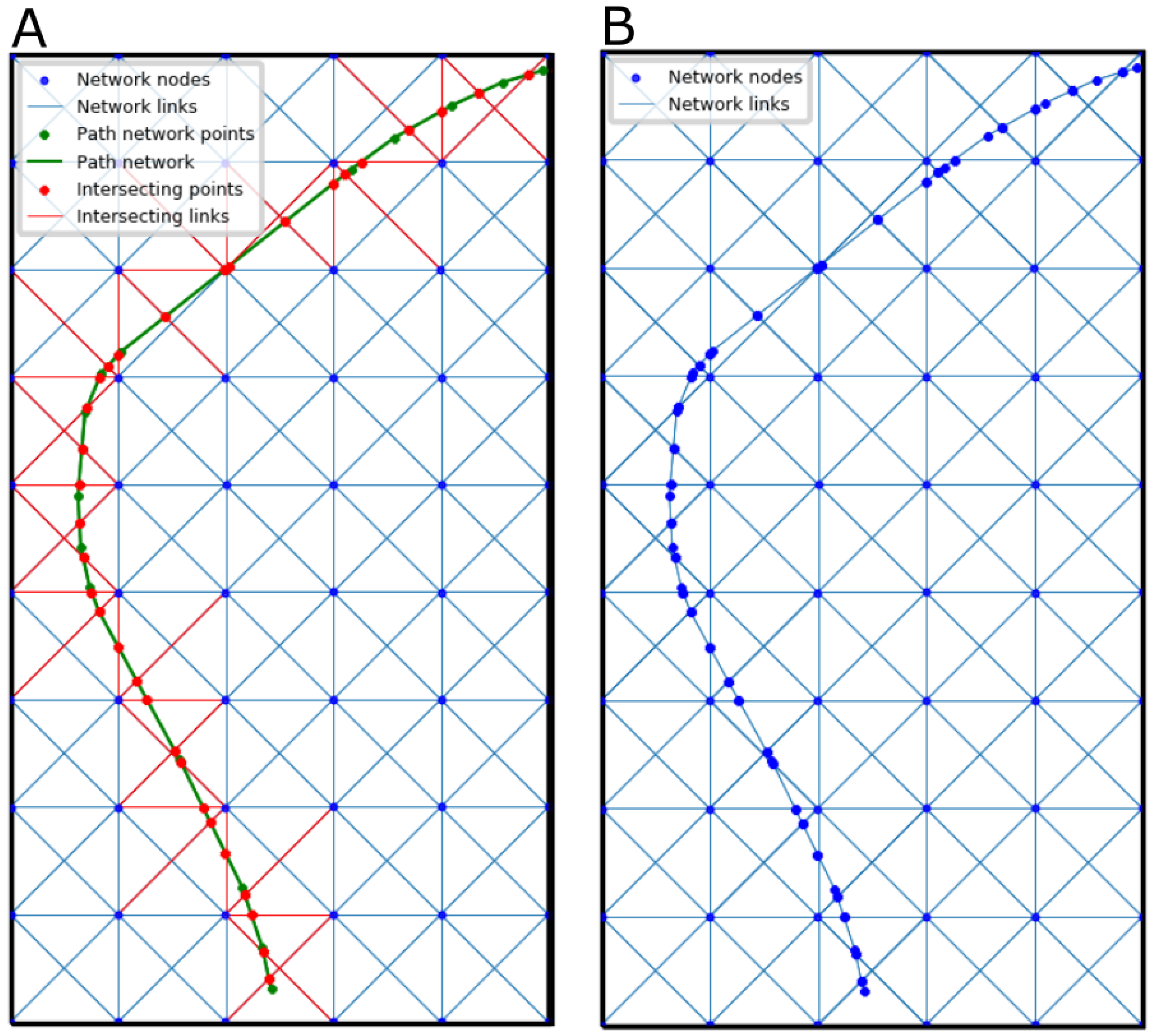
Integrating a Path Network
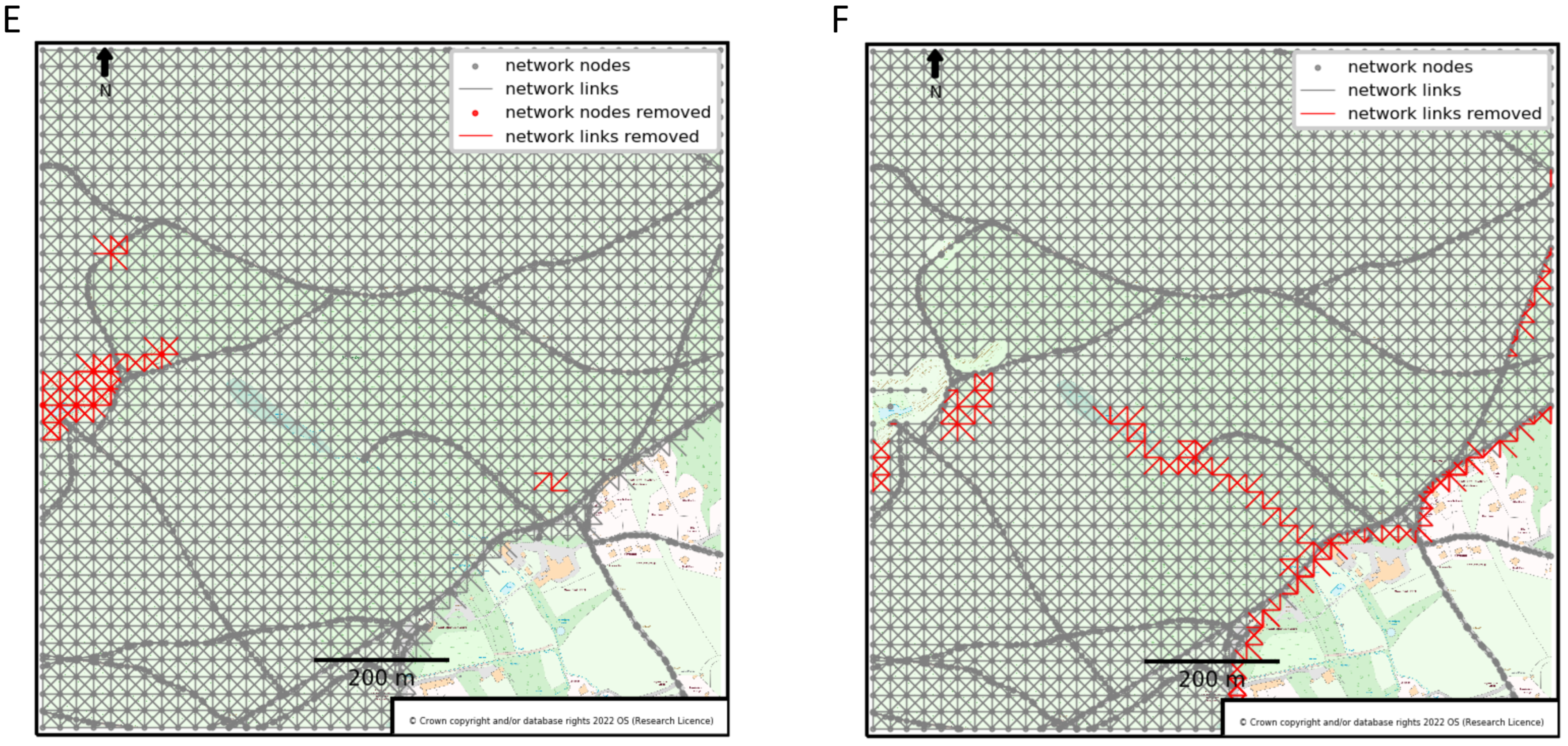
Removing Obstructions, Hazards and Private Land
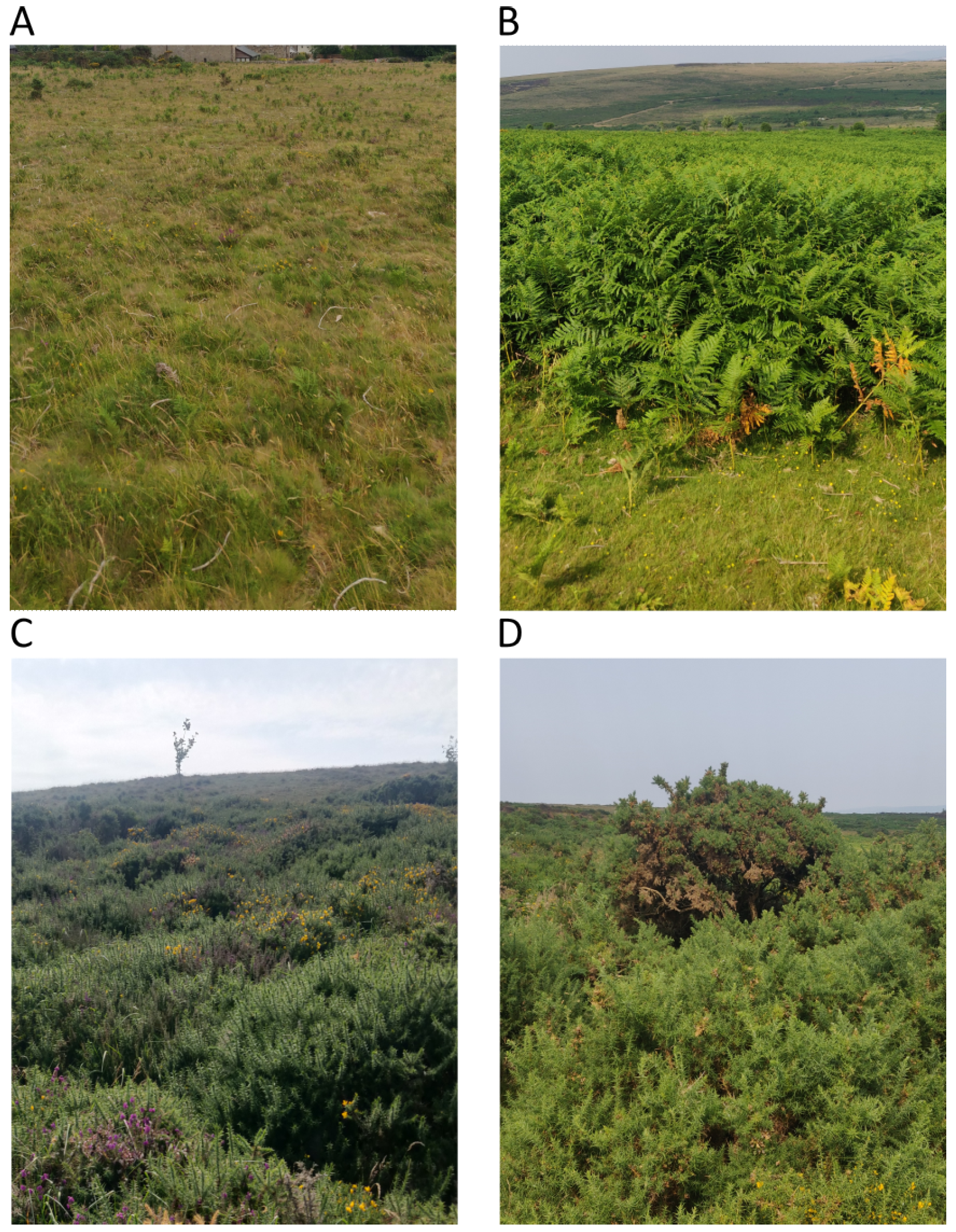
Incorporating Land Cover
3.2.3. Creating Routes
Single Criterion vs. Multi-Criteria Routes
Converting Criteria to Be Implemented in Dijkstra’s Algorithm
Choosing a Weighting Method
4. Evaluation Methods
4.1. Study Areas
Haytor Down (SX 7677) and Hound Tor (SX 7478)
4.2. Routes
- Average PN as %: average percentage of the route that is on the Path Network;
- Average surface cost: average surface cost score over all the routes;
- Average gradient in degrees: average gradient change across all routes;
- Average total time in minutes: estimated average walking time in minutes across all routes, calculated using Naismith’s rule;
- Average total length in metres: average distance of the routes in metres.
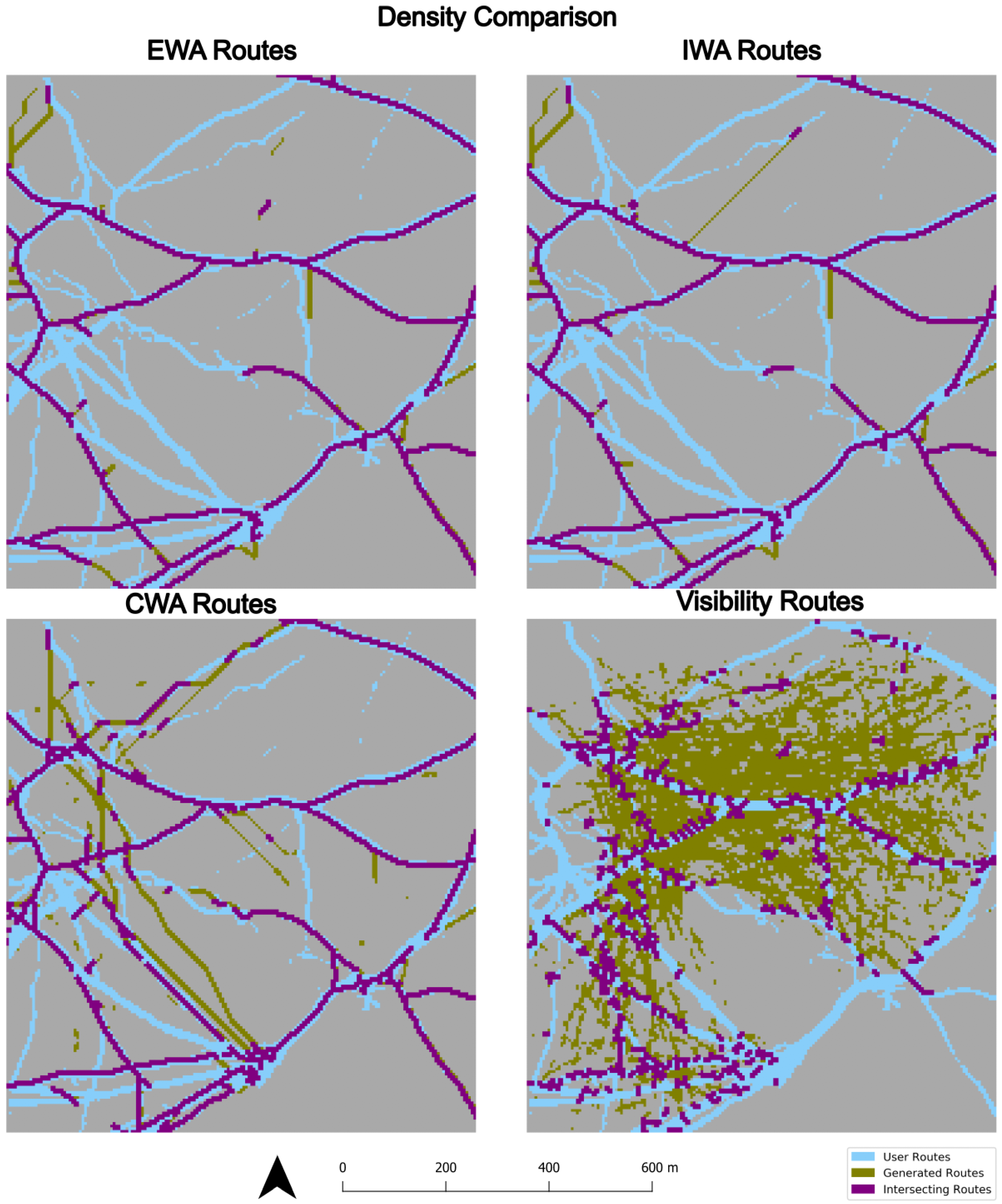
5. Results and Discussion
6. Conclusions and Recommendations
- Inform national park agencies on where to create alternative routes when erosion of the footpath means that a path must be diverted;
- Make protected habitats inaccessible to users and prevent further damage and disruption of local ecosystems;
- Provide alternative routing in emergency scenarios, such as finding the most favourable route for the evacuation of people due to flooding or landslides.
Author Contributions
Funding
Institutional Review Board Statement
Data Availability Statement
Conflicts of Interest
Abbreviations
| PN | Path Network |
| OS | Ordnance Survey |
| EWA | Easy Walking Ability |
| IWA | Intermediate Walking Ability |
| CWA | Challenging Walking Ability |
| MCDM | Multi-Criteria Decision Making |
| WSM | Weighted Sum Method |
Appendix A
References
- Ramblers. Access to Open Countryside—Ramblers, 2020. Available online: https://www.ramblers.org.uk/policy/england/access/access-to-wild-open-countryside-or-the-right-to-roam.aspx (accessed on 24 August 2022).
- Taylor, K.L.; Fitzsimons, C.; Mutrie, N. Objective and subjective assessments of normal walking pace, in comparison with that recommended for moderate intensity physical activity. Int. J. Exerc. Sci. 2010, 3, 87. [Google Scholar]
- Soule, R.G.; Goldman, R.F. Terrain coefficients for energy cost prediction. J. Appl. Physiol. 1972, 32, 706–708. [Google Scholar] [CrossRef]
- Çalişkan, E.; Bediroglu, Ş.; Yildirim, V. Determination forest road routes via GIS-based spatial multi-criterion decision methods. Appl. Ecol. Environ. Res. 2019, 17, 759–779. [Google Scholar] [CrossRef]
- Andreev, S.; Dibbelt, J.; Nöllenburg, M.; Pajor, T.; Wagner, D. Towards Realistic Pedestrian Route Planning. In Proceedings of the 15th Workshop on Algorithmic Approaches for Transportation Modelling, Optimization, and Systems (ATMOS 2015), Patras, Greece, 17 September 2015; Italiano, G.F., Schmidt, M., Eds.; Schloss Dagstuhl–Leibniz-Zentrum fuer Informatik: Dagstuhl, Germany, 2015; Volume 48, pp. 1–15, ISSN 2190-6807. [Google Scholar] [CrossRef]
- Kien Hua, T.; Abdullah, N. Weighted Sum-Dijkstra’s Algorithm in Best Path Identification based on Multiple Criteria. J. Comput. Sci. Comput. Math. 2018, 8, 107–113. [Google Scholar] [CrossRef]
- Çalişkan, E. Planning of environmentally sound forest road route using GIS & S-MCDM. Šumarski List 2017, 141, 583–591. [Google Scholar] [CrossRef][Green Version]
- Hahmann, S.; Miksch, J.; Resch, B.; Lauer, J.; Zipf, A. Routing through open spaces—A performance comparison of algorithms. Geo-Spat. Inf. Sci. 2018, 21, 247–256. [Google Scholar] [CrossRef]
- Graser, A. Integrating Open Spaces into OpenStreetMap Routing Graphs for Realistic Crossing Behaviour in Pedestrian Navigation. GI_Forum 2016, 1, 217–230. [Google Scholar] [CrossRef][Green Version]
- Chen, Y.; Wu, G.; Zhao, T.; Chen, F. An Approach for Generating Pedestrian Network Based on Improved Navigation Graph. Int. J. Hybrid Inf. Technol. 2017, 10, 21–32. [Google Scholar] [CrossRef]
- Ebrahimi, H.; Tadic, M. Optimization of dangerous goods transport in urban zone. Decis. Mak. Appl. Manag. Eng. 2018, 1, 131–152. [Google Scholar] [CrossRef]
- Pamučar, D.; Gigović, L.; Ćirović, G.; Regodić, M. Transport spatial model for the definition of green routes for city logistics centers. Environ. Impact Assess. Rev. 2016, 56, 72–87. [Google Scholar] [CrossRef]
- Rosita, Y.D.; Rosyida, E.E.; Rudiyanto, M.A. Implementation of Dijkstra Algorithm and Multi-Criteria Decision-Making for Optimal Route Distribution. Procedia Comput. Sci. 2019, 161, 378–385. [Google Scholar] [CrossRef]
- Malczewski, J. On the Use of Weighted Linear Combination Method in GIS: Common and Best Practice Approaches. Trans. GIS 2000, 4, 5–22. [Google Scholar] [CrossRef]
- Lakshmi, M.T.M.; Vetriselvi, K.; Anand, A.J.; Venkatesan, D.V.P. A Study on Different Types of Normalization Methods in Adaptive Technique for Order Preference by Similarity to Ideal Solution (TOPSIS). Int. J. Eng. Res. 2016, 4. Available online: https://www.ijert.org/research/a-study-on-different-types-of-normalization-methods-in-adaptive-technique-for-order-preference-by-similarity-to-ideal-solution-topsis-IJERTCONV4IS05004.pdf (accessed on 21 March 2024).
- Odu, G.O. Weighting methods for multi-criteria decision making technique. J. Appl. Sci. Environ. Manag. 2019, 23, 1449–1457. [Google Scholar] [CrossRef]
- Glynn, C. OrdnanceSurvey/OS-British-National-Grids: A Free Set of Grids at Various Resolutions for Ordnance Survey’s National Grid. 2021. Available online: https://github.com/OrdnanceSurvey/OS-British-National-Grids (accessed on 2 August 2022).
- Ordnance Survey. Os-Detailed-Path-Network-Product-Guide, 2017. Available online: https://www.ordnancesurvey.co.uk/products/os-detailed-path-network (accessed on 2 August 2022).
- Ordnance Survey. Os-Mastermap-Topography-Layer-Technical-Specification, 2017. Available online: https://www.ordnancesurvey.co.uk/products/os-mastermap-topography-layer (accessed on 2 August 2022).
- Ordnance Survey (GB). OS MasterMap ® Topography Layer [GeoPackage Geospatial Data], 2021. Available online: https://digimap.edina.ac.uk (accessed on 2 August 2022).
- Ordnance Survey. Os-Terrain-5-User-Guide, 2017. Available online: https://www.ordnancesurvey.co.uk/products/os-terrain-5 (accessed on 2 August 2022).
- Ware, G. Access Land & Dartmoor Commons, 2017. Available online: https://data-dcc.opendata.arcgis.com/datasets/access-land-dartmoor-commons (accessed on 30 September 2022).
- Ramblers. Access Land in England and Wales—Ramblers, 2022. Available online: https://www.ramblers.org.uk/accessguide (accessed on 24 September 2022).
- Gatis, N.; Carless, D.; Luscombe, D.J.; Brazier, R.E.; Anderson, K. An operational land cover and land cover change toolbox: Processing open-source data with open-source software. Ecol. Solut. Evid. 2022, 3, e12162. [Google Scholar] [CrossRef]
- Naismith, W.W. Cruach Ardran, Stobinian, and Ben More. Scott. Mt. Club 1892, 2, 135. [Google Scholar]
- Gast, K.; Kram, R.; Riemer, R. Preferred walking speed on rough terrain; is it all about energetics? J. Exp. Biol. 2019, 222, jeb.185447. [Google Scholar] [CrossRef] [PubMed]
- Givoni, B.; Goldman, R.F. Predicting metabolic energy cost. J. Appl. Physiol. 1971, 30, 429–433. [Google Scholar] [CrossRef] [PubMed]
- Pandolf, K.B.; Givoni, B.; Goldman, R.F. Predicting energy expenditure with loads while standing or walking very slowly. J. Appl. Physiol. 1977, 43, 577–581. [Google Scholar] [CrossRef]
- de Gruchy, M.; Caswell, E.; Edwards, J. Velocity-Based Terrain Coefficients for Time-Based Models of Human Movement. Internet Archaeol. 2017, 45. [Google Scholar] [CrossRef]
- Herzog, I. Least-Cost Paths—Some Methodological Issues, 2014. Available online: https://intarch.ac.uk/journal/issue36/5/5-3.html (accessed on 5 September 2022).
- Butcher, B. UK Habitat Classification—Habitat Definitions, 2018. Available online: https://ecountability.co.uk/wp-content/uploads/2018/05/UK-Habitat-Classification-Habitat-Definitions-V1.0-May-2018-1.pdf (accessed on 1 August 2022).
- European Commission. Forest Observations, 2015. Available online: https://forobs.jrc.ec.europa.eu/products/gam/sources.php (accessed on 5 October 2022).
- John, T. Gorse, 2016. Available online: https://dartmoorlinks.co.uk/api/content/916d1ba6-54d5-11e6-ae0d-12955eaaf839/ (accessed on 31 August 2022).
- Gourisetti, S.N.G.; Mylrea, M.; Patangia, H. Application of Rank-Weight Methods to Blockchain Cybersecurity Vulnerability Assessment Framework. In Proceedings of the 2019 IEEE 9th Annual Computing and Communication Workshop and Conference (CCWC), Las Vegas, NV, USA, 7–9 January 2019; pp. 0206–0213. [Google Scholar] [CrossRef]
- Roszkowska, E. Rank Ordering Criteria Weighting Methods—A Comparative Overview. Optimum. Econ. Stud. 2013, 5, 14–33. [Google Scholar] [CrossRef]
- Ordnance Survey. Technical Difficulties, 2022. Available online: https://osmaps.com/technical-difficulties (accessed on 3 August 2022).
- Renzel, P. Ramblers Cymru—Key facts Report, 2018. Available online: https://www.ramblers.org.uk/-/media/Files/Wales%20microsite/Ramblers%20Cymru%20-%20Key%20Facts%20Report%202018.ashx (accessed on 1 August 2022).
- Komoot. Off-Grid Tour Planning Outside of Komoot’s Routing Network, 2022. Available online: https://support.komoot.com/hc/en-us/articles/360024733651-Off-grid-Tour-planning-outside-of-komoot-s-routing-network (accessed on 2 August 2022).
- den Bossche, J.V.; Fleischmann, M.; Jordahl, K. Geopandas/Geopandas: Python Tools for Geographic Data, 2022. Available online: https://github.com/geopandas/geopandas (accessed on 16 March 2024).
- Shavit, A.; Snow, A.D.; Rubiales, A.; Adair, A. Shapely—Shapely 2.0.3 Documentation, 2024. Available online: https://shapely.readthedocs.io/en/stable/index.html (accessed on 16 March 2024).
- Gillies, S. Introduction—Rasterio Documentation, 2021. Available online: https://rasterio.readthedocs.io/en/stable/intro.html (accessed on 16 March 2024).
- Hagberg, A.; Schult, D.; Swart, P. NetworkX—NetworkX Documentation, 2023. Available online: https://networkx.org/ (accessed on 16 March 2024).
- Reksten-Monsen, C.A. TaipanRex/Pyvisgraph: Given a List of Simple Obstacle Polygons, Build the Visibility Graph and Find the Shortest Path between Two Points, 2016. Available online: https://github.com/TaipanRex/pyvisgraph (accessed on 16 March 2024).




| Gatis et al. 2022 [24] | CEH LCM2019 [24] | |||
|---|---|---|---|---|
| Class Label | Accuracy (%) | Areal Extent (km2) | Areal Extent (km2) | Class Label |
| Lowland acid grassland | 78.4 | 22.9 | 372.6 | Acid Grassland |
| Upland acid grassland | 78.4 | 57.1 | ||
| Bracken | 80.0 | 175.5 | ||
| 0.1 | Calcareous Grassland | |||
| Lowland meadows | 70.8 | 1.5 | 1.9 | Neutral Grassland |
| Upland hay meadows | 70.8 | 0.5 | ||
| Modified grassland | 79.7 | 273.2 | 271.3 | Improved Grassland |
| Upland oakwood | 0.0 | 0.4 | 122.3 | Broadleaved woodland |
| Other broadleaved, mixed and yew woodland | 79.5 | 136.9 | ||
| Coniferous woodland | 100.0 | 23.5 | 34.5 | Coniferous woodland |
| Lowland Heathland | 54.7 | 13.5 | 12.7 | Heather |
| Upland Heathland | 54.7 | 58.1 | 0.1 | Heather grassland |
| Gorse scrub | 45.5 | 10.5 | ||
| Blanket bog | 75.0 | 6.2 | 97.4 | Bog |
| Acid grass over degraded blanket bog | 70.0 | 79.5 | ||
| Heathland over degraded blanket bog | 70.0 | 41.2 | ||
| Unvegetated degraded blanket bog | 70.0 | 6.2 | ||
| Purple moor grass and rush pastures | 61.5 | 9.2 | ||
| Flushes, fens, marsh, and swamp | 90.0 | 5.4 | 0.0 | Fen, Marsh, and Swamp |
| Cropland | 73.9 | 5.8 | 22.9 | Arable and Horticulture |
| Urban | 59.3 | 19.8 | 0.8 | Urban |
| 0.0 | 18.2 | Suburban | ||
| Inland rock | 62.5 | 5.3 | 0.1 | Inland Rock |
| Rivers and lakes | 93.8 | 3.0 | 0.7 | Freshwater |
| Terrain | Coefficient |
|---|---|
| Asphalt/blacktop | 1.0 |
| Grass and Dirt road | 1.1 |
| Light brush | 1.2 |
| Ploughed field | 1.3 |
| Heavy brush | 1.5 |
| Hard-packed snow | 1.6 |
| Swampy bog | 1.8 |
| Loose sand | 2.0 |
| Terrain | Coefficient | Land Cover Classification |
|---|---|---|
| Asphalt/blacktop | 1.0 | Urban |
| Grass and Dirt road | 1.1 | Lowland acid grassland, Upland acid grassland, Modified grassland |
| Light brush | 1.2 | Bracken, Lowland meadows, Upland hay meadows |
| Ploughed field | 1.3 | Cropland |
| Unclassified | 1.4 | Acid grass over degraded blanket bog, Unvegetated degraded blanket bog |
| Heavy brush | 1.5 | Upland oakwood, Other broadleaved, mixed and yew woodland, Coniferous woodland, Lowland Heathland, Upland Heathland, |
| Hard-packed snow | 1.6 | |
| Swampy bog | 1.8 | Purple moor grass and rush pastures, Blanket Bog, |
| Loose sand | 2.0 | |
| Hazardous | 3.0 | Gorse Scrubland, Flushes, fens, marsh and swamp, inland rock |
| Easy | Moderate | Difficult | Severe | |
|---|---|---|---|---|
| Gradient | Generally Flat | Moderate gradient | Steep ascents and descents | Very steep ascents and descents |
| Remoteness | Never far from the road or an access point | Route could be exited in around one hour | Route could be exited in a few hours | Upland or very remote areas far from any habitation; could take over half a day to exit the route |
| Path type | Generally accessible paths, surface usually paved or hardened | Narrower paths but mostly firm and stable surfaces, rocks and other obstacles maybe be present | Mountainous with steep, rocky sections requiring very good coordination; may involve crossing streams or marshes | Involves non-existent or unmarked trails and scrambles, technical equipment such as rope may be required |
| Navigations | Well-marked paths, only basic navigation required | Paths generally well defined, signage or marking may also be present | Little signage, paths may be poorly defined; map and compass skills essential, particularly in poor weather | “Off-the-beaten-track”: extensive navigation experience using compass required |
| Criteria | Gradient | PN | Surface Cost | Total Time |
|---|---|---|---|---|
| Easy | 3 | 1 | 2 | 4 |
| Intermediate | 4 | 1 | 3 | 2 |
| Challenging | 4 | 3 | 2 | 1 |
| Criteria | Gradient | PN | Surface Cost | Total Time |
|---|---|---|---|---|
| Easy | 0.045 | 0.723 | 0.229 | 0.0028 |
| Intermediate | 0.0028 | 0.723 | 0.045 | 0.229 |
| Challenging | 0.0028 | 0.045 | 0.229 | 0.723 |
| Avg. PN(%) | Avg. Surface Cost | Avg. Gradient (°) | Avg. Total Time (min) | Avg. Total Length (m) | |
|---|---|---|---|---|---|
| Visibility | 10.25 | 1.50 | 3.90 | 9.41 | 607.42 |
| Unweighted | 63.26 | 1.19 | 3.51 | 9.63 | 637.42 |
| Easy (EWA) | 97.01 | 1.04 | 3.31 | 11.00 | 735.26 |
| Intermediate (IWA) | 96.70 | 1.04 | 3.31 | 10.90 | 728.41 |
| Challenging (CWA) | 83.21 | 1.08 | 3.36 | 9.79 | 652.60 |
| Avg. PN(%) | Avg. Surface Cost | Avg. Gradient (°) | Avg. Total Time (min) | Avg. Total Length (m) | |
|---|---|---|---|---|---|
| Visibility | 10.54 | 1.31 | 3.30 | 4.68 | 326.06 |
| Unweighted | 72.68 | 1.11 | 4.43 | 11.93 | 732.01 |
| Easy (EWA) | 88.85 | 1.08 | 4.51 | 12.64 | 772.25 |
| Intermediate (IWA) | 88.90 | 1.08 | 4.50 | 12.59 | 769.25 |
| Challenging (CWA) | 79.10 | 1.09 | 4.30 | 11.95 | 736.60 |
Disclaimer/Publisher’s Note: The statements, opinions and data contained in all publications are solely those of the individual author(s) and contributor(s) and not of MDPI and/or the editor(s). MDPI and/or the editor(s) disclaim responsibility for any injury to people or property resulting from any ideas, methods, instructions or products referred to in the content. |
© 2024 by the authors. Licensee MDPI, Basel, Switzerland. This article is an open access article distributed under the terms and conditions of the Creative Commons Attribution (CC BY) license (https://creativecommons.org/licenses/by/4.0/).
Share and Cite
Sprent, R.F.; Haworth, J.; Cavazzi, S.; Ilyankou, I. Multi-Criteria Framework for Routing on Access Land: A Case Study on Dartmoor National Park. ISPRS Int. J. Geo-Inf. 2024, 13, 130. https://doi.org/10.3390/ijgi13040130
Sprent RF, Haworth J, Cavazzi S, Ilyankou I. Multi-Criteria Framework for Routing on Access Land: A Case Study on Dartmoor National Park. ISPRS International Journal of Geo-Information. 2024; 13(4):130. https://doi.org/10.3390/ijgi13040130
Chicago/Turabian StyleSprent, Rafael Felipe, James Haworth, Stefano Cavazzi, and Ilya Ilyankou. 2024. "Multi-Criteria Framework for Routing on Access Land: A Case Study on Dartmoor National Park" ISPRS International Journal of Geo-Information 13, no. 4: 130. https://doi.org/10.3390/ijgi13040130
APA StyleSprent, R. F., Haworth, J., Cavazzi, S., & Ilyankou, I. (2024). Multi-Criteria Framework for Routing on Access Land: A Case Study on Dartmoor National Park. ISPRS International Journal of Geo-Information, 13(4), 130. https://doi.org/10.3390/ijgi13040130


