

Applying Dynamic Human Activity to Disentangle Property Crime Patterns in London during the Pandemic: An Empirical Analysis Using Geo-Tagged Big Data

Abstract
:1. Introduction
2. Review of Related Works
2.1. Theoretical Approaches and Crime Shifting during the COVID-19 Pandemic
2.2. Geo-Tagged Big Data for Crime Analytics
3. Data
3.1. Study Area and Unit of Analysis
3.2. London-Police-Recorded Data
3.3. Socioeconomic Data
3.4. Place Data
3.5. Mobile Phone GPS Trajectory Data
4. Methods
4.1. Generation of Human Activity Variables
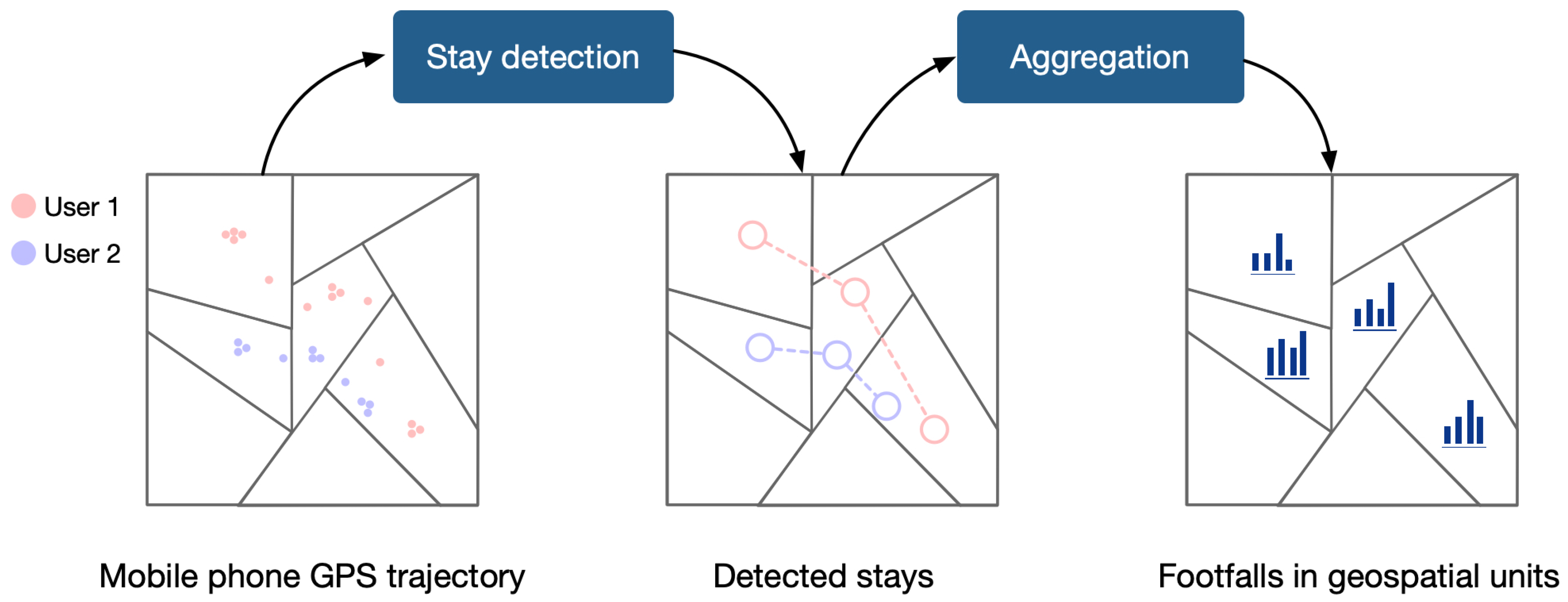
4.1.1. Footfall Generation from GPS Trajectory
4.1.2. Characterising Dynamic Human Activity
4.2. Models
4.2.1. LASSO Regression Model
4.2.2. LASSO Model Training Setup
4.2.3. Geographically Weighted Regression Model
5. Results
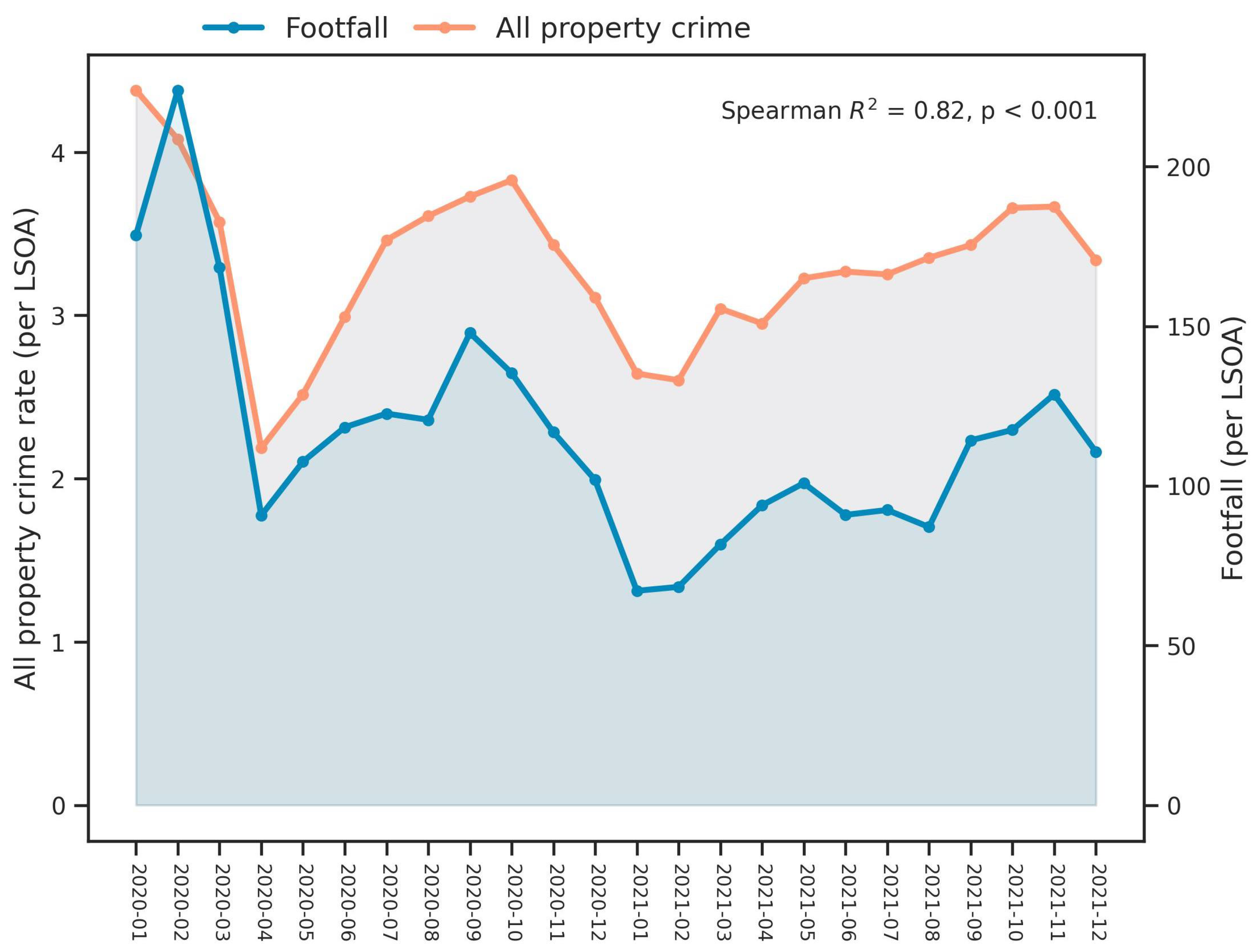
5.1. Description of Explanatory Variables and Property Crime Rates
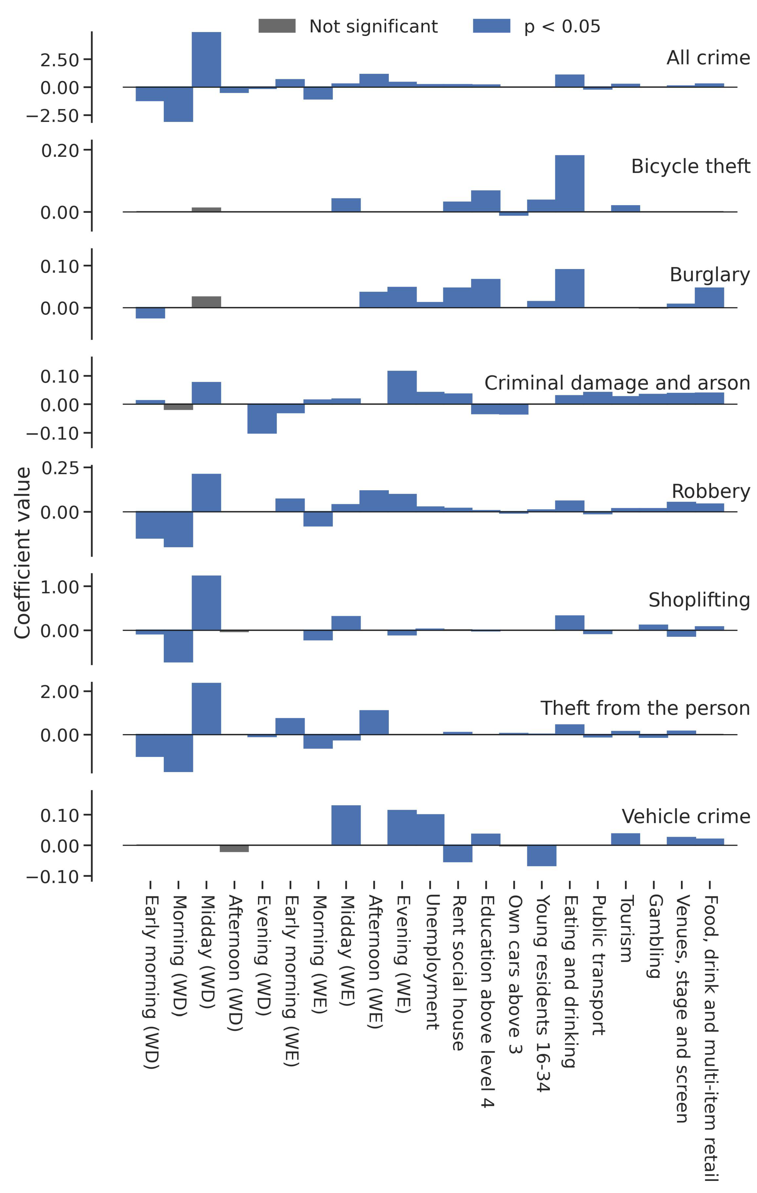
5.2. Optimised LASSO Models for Property Crimes
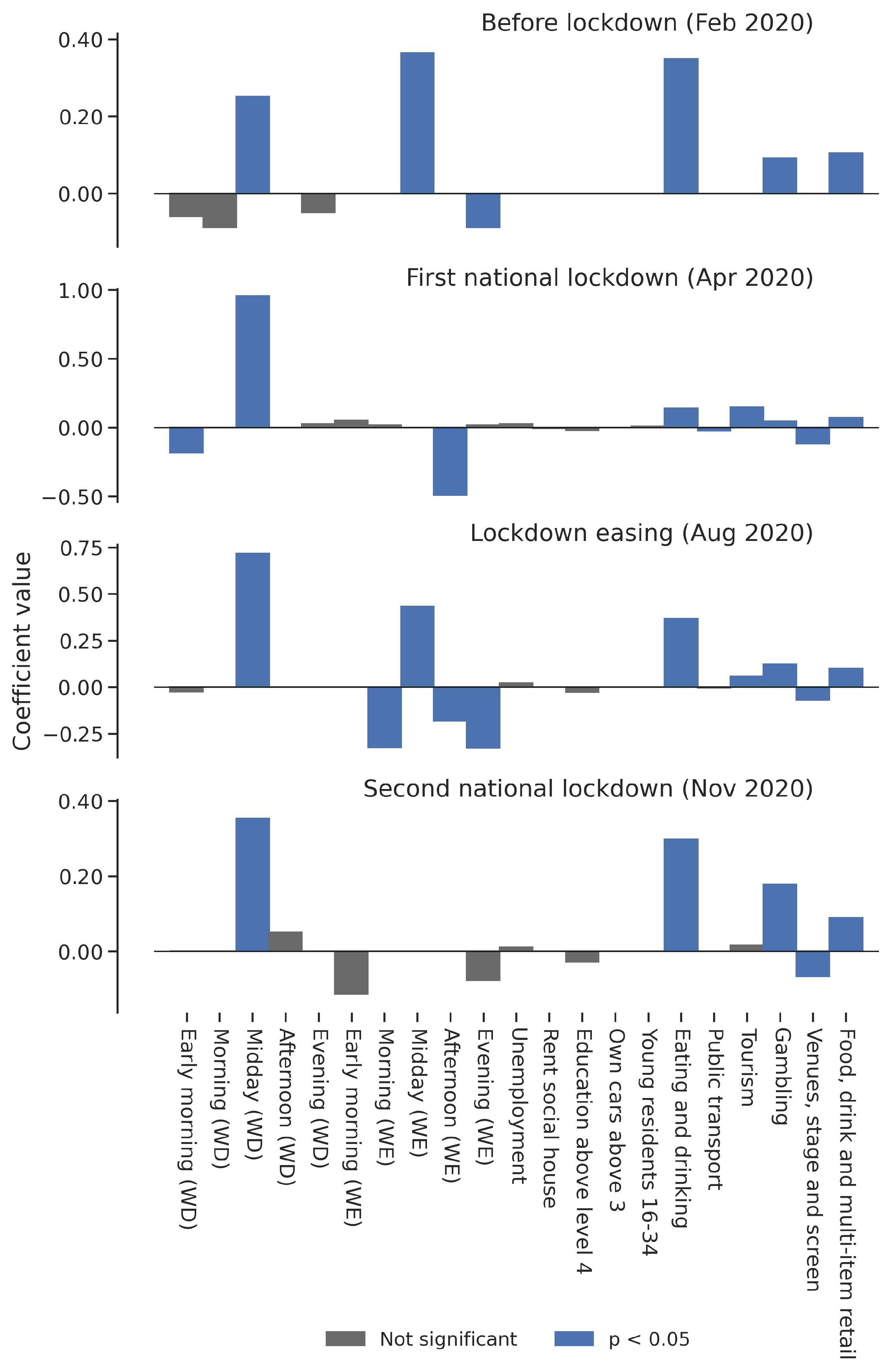
5.3. The Global Relationships between All Human Activity Variables and Theft in Four Pandemic Periods
5.4. The Spatial Relationships between Selected Human Activity Variables and Theft in Four Pandemic Periods
6. Discussion
7. Conclusions
Author Contributions
Funding
Data Availability Statement
Conflicts of Interest
Abbreviations
| RAT | Routine activity theory |
| CPT | Crime pattern theory |
| SDT | Social disorganisation theory |
| CDR | Call detail record |
| GPS | Global positioning system |
| UK | United Kingdom |
| ONS | Office for National Statistics |
| LSOAs | Lower super output areas |
| POI | Point of interest |
| WD | Weekdays |
| WE | Weekends |
| MDAF | Monthly daily average footfall |
| LASSO | Least Absolute Shrinkage and Selection Operator |
| RMSE | Root-mean-squared error |
Appendix A


References
- Hale, T.; Webster, S.; Petherick, A.; Phillips, T.; Kira, B. Oxford COVID-19 government response tracker (OxCGRT). Last Updat. 2020, 8, 30. [Google Scholar]
- Cheng, T.; Chen, T.; Liu, Y.; Aldridge, R.W.; Nguyen, V.; Hayward, A.C.; Michie, S. Human mobility variations in response to restriction policies during the COVID-19 pandemic: An analysis from the Virus Watch community cohort in England, UK. Front. Public Health 2022, 10, 999521. [Google Scholar] [CrossRef] [PubMed]
- Ashby, M.P. Changes in police calls for service during the early months of the 2020 coronavirus pandemic. Polic. J. Policy Pract. 2020, 14, 1054–1072. [Google Scholar] [CrossRef]
- Ashby, M.P. Initial evidence on the relationship between the coronavirus pandemic and crime in the United States. Crime Sci. 2020, 9, 6. [Google Scholar] [CrossRef] [PubMed]
- Campedelli, G.M.; Aziani, A.; Favarin, S. Exploring the immediate effects of COVID-19 containment policies on crime: An empirical analysis of the short-term aftermath in Los Angeles. Am. J. Crim. Justice 2021, 46, 704–727. [Google Scholar] [CrossRef] [PubMed]
- Langton, S.; Dixon, A.; Farrell, G. Six months in: Pandemic crime trends in England and Wales. Crime Sci. 2021, 10, 6. [Google Scholar] [CrossRef] [PubMed]
- Mohler, G.; Bertozzi, A.L.; Carter, J.; Short, M.B.; Sledge, D.; Tita, G.E.; Uchida, C.D.; Brantingham, P.J. Impact of social distancing during COVID-19 pandemic on crime in Los Angeles and Indianapolis. J. Crim. Justice 2020, 68, 101692. [Google Scholar] [CrossRef]
- Felson, M.; Jiang, S.; Xu, Y. Routine activity effects of the COVID-19 pandemic on burglary in Detroit, March, 2020. Crime Sci. 2020, 9, 10. [Google Scholar] [CrossRef]
- Nivette, A.E.; Zahnow, R.; Aguilar, R.; Ahven, A.; Amram, S.; Ariel, B.; Burbano, M.J.A.; Astolfi, R.; Baier, D.; Bark, H.M.; et al. A global analysis of the impact of COVID-19 stay-at-home restrictions on crime. Nat. Hum. Behav. 2021, 5, 868–877. [Google Scholar] [CrossRef]
- Balmori de la Miyar, J.R.; Hoehn-Velasco, L.; Silverio-Murillo, A. The U-shaped crime recovery during COVID-19: Evidence from national crime rates in Mexico. Crime Sci. 2021, 10, 14. [Google Scholar] [CrossRef]
- Buil-Gil, D.; Zeng, Y.; Kemp, S. Offline crime bounces back to pre-COVID levels, cyber stays high: Interrupted time-series analysis in Northern Ireland. Crime Sci. 2021, 10, 26. [Google Scholar] [CrossRef] [PubMed]
- Koppel, S.; Capellan, J.A.; Sharp, J. Disentangling the impact of COVID-19: An interrupted time series analysis of crime in New York city. Am. J. Crim. Justice 2022, 48, 368–394. [Google Scholar] [CrossRef] [PubMed]
- Estévez-Soto, P.R. Crime and COVID-19: Effect of changes in routine activities in Mexico City. Crime Sci. 2021, 10, 15. [Google Scholar] [CrossRef] [PubMed]
- Halford, E.; Dixon, A.; Farrell, G.; Malleson, N.; Tilley, N. Crime and coronavirus: Social distancing, lockdown, and the mobility elasticity of crime. Crime Sci. 2020, 9, 11. [Google Scholar] [CrossRef] [PubMed]
- Cohen, L.E.; Felson, M. Social Change and Crime Rate Trends: A Routine Activity Approach. Am. Sociol. Rev. 1979, 44, 588–608. [Google Scholar] [CrossRef]
- Brantingham, P.J.; Brantingham, P.L. Patterns in Crime; Macmillan: New York, NY, USA, 1984. [Google Scholar]
- Felson, M.; Cohen, L.E. Human ecology and crime: A routine activity approach. Hum. Ecol. 1980, 8, 389–406. [Google Scholar] [CrossRef]
- Felson, M. The routine activity approach. In Environmental Criminology and Crime Analysis; Routledge: London, UK, 2016; pp. 106–116. [Google Scholar]
- Brantingham, P.J.; Brantingham, P.L. The geometry of crime and crime pattern theory. In Environmental Criminology and Crime Analysis; Routledge: London, UK, 2016; pp. 117–135. [Google Scholar]
- Brantingham, P.J.; Brantingham, P.L. Criminality of place: Crime generators and crime attractors. Eur. J. Crim. Policy Res. 1995, 3, 5–26. [Google Scholar] [CrossRef]
- Sampson, R.J.; Raudenbush, S.W.; Earls, F. Neighborhoods and violent crime: A multilevel study of collective efficacy. Science 1997, 277, 918–924. [Google Scholar] [CrossRef]
- Sampson, R.J.; Raudenbush, S.W. Systematic social observation of public spaces: A new look at disorder in urban neighborhoods. Am. J. Sociol. 1999, 105, 603–651. [Google Scholar] [CrossRef]
- Sampson, R.J. Neighbourhood effects and beyond: Explaining the paradoxes of inequality in the changing American metropolis. Urban Stud. 2019, 56, 3–32. [Google Scholar] [CrossRef]
- Chen, T.; Bowers, K.; Zhu, D.; Gao, X.; Cheng, T. Spatio-temporal stratified associations between urban human activities and crime patterns: A case study in San Francisco around the COVID-19 stay-at-home mandate. Comput. Urban Sci. 2022, 2, 13. [Google Scholar] [CrossRef] [PubMed]
- Campedelli, G.M.; Favarin, S.; Aziani, A.; Piquero, A.R. Disentangling community-level changes in crime trends during the COVID-19 pandemic in Chicago. Crime Sci. 2020, 9, 21. [Google Scholar] [CrossRef] [PubMed]
- Cheung, L.; Gunby, P. Crime and mobility during the COVID-19 lockdown: A preliminary empirical exploration. N. Z. Econ. Pap. 2022, 56, 106–113. [Google Scholar] [CrossRef]
- Frith, M.J.; Bowers, K.J.; Johnson, S.D. Household occupancy and burglary: A case study using COVID-19 restrictions. J. Crim. Justice 2022, 82, 101996. [Google Scholar] [CrossRef] [PubMed]
- Bursik, R.J., Jr. Urban dynamics and ecological studies of delinquency. Soc. Forces 1984, 63, 393–413. [Google Scholar] [CrossRef]
- Sampson, R.J.; Groves, W.B. Community structure and crime: Testing social-disorganization theory. Am. J. Sociol. 1989, 94, 774–802. [Google Scholar] [CrossRef]
- Jones, R.W.; Pridemore, W.A. Toward an integrated multilevel theory of crime at place: Routine activities, social disorganization, and the law of crime concentration. J. Quant. Criminol. 2019, 35, 543–572. [Google Scholar] [CrossRef]
- Weisburd, D. The law of crime concentration and the criminology of place. Criminology 2015, 53, 133–157. [Google Scholar] [CrossRef]
- Brantingham, P.J. Crime diversity. Criminology 2016, 54, 553–586. [Google Scholar] [CrossRef]
- Prelog, A.J. Modeling the relationship between natural disasters and crime in the United States. Nat. Hazards Rev. 2016, 17, 04015011. [Google Scholar] [CrossRef]
- Rumbach, A.; Makarewicz, C.; Németh, J. The importance of place in early disaster recovery: A case study of the 2013 Colorado floods. J. Environ. Plan. Manag. 2016, 59, 2045–2063. [Google Scholar] [CrossRef]
- Tierney, K.; Bevc, C.; Kuligowski, E. Metaphors matter: Disaster myths, media frames, and their consequences in Hurricane Katrina. Ann. Am. Acad. Political Soc. Sci. 2006, 604, 57–81. [Google Scholar] [CrossRef]
- Andresen, M.A.; Hodgkinson, T. In a world called catastrophe: The impact of COVID-19 on neighbourhood level crime in Vancouver, Canada. J. Exp. Criminol. 2023, 19, 487–511. [Google Scholar] [CrossRef] [PubMed]
- Hodgkinson, T.; Andresen, M.A.; Frank, R.; Pringle, D. Crime down in the Paris of the prairies: Spatial effects of COVID-19 and crime during lockdown in Saskatoon, Canada. J. Crim. Justice 2022, 78, 101881. [Google Scholar] [CrossRef]
- MacEachren, A.M. Leveraging big (geo) data with (geo) visual analytics: Place as the next frontier. In Spatial Data Handling in Big Data Era; Springer: Berlin/Heidelberg, Germany, 2017; pp. 139–155. [Google Scholar]
- Barbosa, H.; Barthelemy, M.; Ghoshal, G.; James, C.R.; Lenormand, M.; Louail, T.; Menezes, R.; Ramasco, J.J.; Simini, F.; Tomasini, M. Human mobility: Models and applications. Phys. Rep. 2018, 734, 1–74. [Google Scholar] [CrossRef]
- Jenkins, A.; Croitoru, A.; Crooks, A.T.; Stefanidis, A. Crowdsourcing a collective sense of place. PLoS ONE 2016, 11, e0152932. [Google Scholar] [CrossRef] [PubMed]
- Haraguchi, M.; Nishino, A.; Kodaka, A.; Allaire, M.; Lall, U.; Kuei-Hsien, L.; Onda, K.; Tsubouchi, K.; Kohtake, N. Human mobility data and analysis for urban resilience: A systematic review. Environ. Plan. Urban Anal. City Sci. 2022, 49, 1507–1535. [Google Scholar] [CrossRef]
- Toch, E.; Lerner, B.; Ben-Zion, E.; Ben-Gal, I. Analyzing large-scale human mobility data: A survey of machine learning methods and applications. Knowl. Inf. Syst. 2019, 58, 501–523. [Google Scholar] [CrossRef]
- Brockmann, D.; Hufnagel, L.; Geisel, T. The scaling laws of human travel. Nature 2006, 439, 462–465. [Google Scholar] [CrossRef]
- Mir, D.J.; Isaacman, S.; Cáceres, R.; Martonosi, M.; Wright, R.N. Dp-where: Differentially private modeling of human mobility. In Proceedings of the 2013 IEEE International Conference on Big Data, Silicon Valley, CA, USA, 6–9 October 2013; pp. 580–588. [Google Scholar]
- Zheng, Y. Trajectory data mining: An overview. ACM Trans. Intell. Syst. Technol. (TIST) 2015, 6, 1–41. [Google Scholar] [CrossRef]
- Alessandretti, L.; Sapiezynski, P.; Lehmann, S.; Baronchelli, A. Multi-scale spatio-temporal analysis of human mobility. PLoS ONE 2017, 12, e0171686. [Google Scholar] [CrossRef] [PubMed]
- Zhao, K.; Tarkoma, S.; Liu, S.; Vo, H. Urban human mobility data mining: An overview. In Proceedings of the 2016 IEEE International Conference on Big Data (Big Data), Washington, DC, USA, 5–8 December 2016; pp. 1911–1920. [Google Scholar]
- Pelletier, M.P.; Trépanier, M.; Morency, C. Smart card data use in public transit: A literature review. Transp. Res. Part C Emerg. Technol. 2011, 19, 557–568. [Google Scholar] [CrossRef]
- Soundararaj, B.; Cheshire, J.; Longley, P. Estimating real-time high-street footfall from Wi-Fi probe requests. Int. J. Geogr. Inf. Sci. 2020, 34, 325–343. [Google Scholar] [CrossRef]
- Bogomolov, A.; Lepri, B.; Staiano, J.; Oliver, N.; Pianesi, F.; Pentland, A. Once upon a crime: Towards crime prediction from demographics and mobile data. In Proceedings of the 16th International Conference on Multimodal Interaction, Istanbul, Turkey, 12–16 November 2014; pp. 427–434. [Google Scholar]
- Malleson, N.; Andresen, M.A. Exploring the impact of ambient population measures on London crime hotspots. J. Crim. Justice 2016, 46, 52–63. [Google Scholar] [CrossRef]
- Long, D.; Liu, L.; Xu, M.; Feng, J.; Chen, J.; He, L. Ambient population and surveillance cameras: The guardianship role in street robbers’ crime location choice. Cities 2021, 115, 103223. [Google Scholar] [CrossRef]
- He, L.; Páez, A.; Jiao, J.; An, P.; Lu, C.; Mao, W.; Long, D. Ambient population and larceny-theft: A spatial analysis using mobile phone data. ISPRS Int. J. Geo-Inf. 2020, 9, 342. [Google Scholar] [CrossRef]
- Hanaoka, K. New insights on relationships between street crimes and ambient population: Use of hourly population data estimated from mobile phone users’ locations. Environ. Plan. B Urban Anal. City Sci. 2018, 45, 295–311. [Google Scholar] [CrossRef]
- Song, G.; Bernasco, W.; Liu, L.; Xiao, L.; Zhou, S.; Liao, W. Crime feeds on legal activities: Daily mobility flows help to explain thieves’ target location choices. J. Quant. Criminol. 2019, 35, 831–854. [Google Scholar] [CrossRef]
- Levy, B.L.; Phillips, N.E.; Sampson, R.J. Triple disadvantage: Neighborhood networks of everyday urban mobility and violence in US cities. Am. Sociol. Rev. 2020, 85, 925–956. [Google Scholar] [CrossRef]
- Kadar, C.; Pletikosa, I. Mining large-scale human mobility data for long-term crime prediction. EPJ Data Sci. 2018, 7, 26. [Google Scholar] [CrossRef]
- Tompson, L.; Johnson, S.; Ashby, M.; Perkins, C.; Edwards, P. UK open source crime data: Accuracy and possibilities for research. Cartogr. Geogr. Inf. Sci. 2015, 42, 97–111. [Google Scholar] [CrossRef]
- Mburu, L.W.; Helbich, M. Crime risk estimation with a commuter-harmonized ambient population. Ann. Am. Assoc. Geogr. 2016, 106, 804–818. [Google Scholar] [CrossRef]
- Sutherland, A.; Brunton-Smith, I.; Jackson, J. Collective efficacy, deprivation and violence in London. Br. J. Criminol. 2013, 53, 1050–1074. [Google Scholar] [CrossRef]
- Browning, C.R.; Calder, C.A.; Soller, B.; Jackson, A.L.; Dirlam, J. Ecological networks and neighborhood social organization. Am. J. Sociol. 2017, 122, 1939–1988. [Google Scholar] [CrossRef] [PubMed]
- Kinney, J.B.; Brantingham, P.L.; Wuschke, K.; Kirk, M.G.; Brantingham, P.J. Crime attractors, generators and detractors: Land use and urban crime opportunities. Built Environ. 2008, 34, 62–74. [Google Scholar] [CrossRef]
- Bernasco, W.; Block, R. Robberies in Chicago: A block-level analysis of the influence of crime generators, crime attractors, and offender anchor points. J. Res. Crime Delinq. 2011, 48, 33–57. [Google Scholar] [CrossRef]
- Belesiotis, A.; Papadakis, G.; Skoutas, D. Analyzing and predicting spatial crime distribution using crowdsourced and open data. ACM Trans. Spat. Algorithms Syst. (TSAS) 2018, 3, 1–31. [Google Scholar] [CrossRef]
- Redfern, J.; Sidorov, K.; Rosin, P.L.; Corcoran, P.; Moore, S.C.; Marshall, D. Association of violence with urban points of interest. PLoS ONE 2020, 15, e0239840. [Google Scholar] [CrossRef]
- Hariharan, R.; Toyama, K. Project Lachesis: Parsing and modeling location histories. In Proceedings of the International Conference on Geographic Information Science, Adelphi, MD, USA, 20–23 October 2004; Springer: Berlin/Heidelberg, Germany, 2004; pp. 106–124. [Google Scholar]
- Pappalardo, L.; Simini, F.; Barlacchi, G.; Pellungrini, R. Scikit-mobility: A Python library for the analysis, generation and risk assessment of mobility data. arXiv 2019, arXiv:1907.07062. [Google Scholar] [CrossRef]
- Yuan, N.J.; Zheng, Y.; Zhang, L.; Xie, X. T-finder: A recommender system for finding passengers and vacant taxis. IEEE Trans. Knowl. Data Eng. 2012, 25, 2390–2403. [Google Scholar] [CrossRef]
- Tompson, L.; Bowers, K. A stab in the dark? A research note on temporal patterns of street robbery. J. Res. Crime Delinq. 2013, 50, 616–631. [Google Scholar] [CrossRef] [PubMed]
- Tibshirani, R. Regression shrinkage and selection via the lasso. J. R. Stat. Soc. Ser. B (Methodol.) 1996, 58, 267–288. [Google Scholar] [CrossRef]
- Tibshirani, R. Regression shrinkage and selection via the lasso: A retrospective. J. R. Stat. Soc. Ser. B (Stat. Methodol.) 2011, 73, 273–282. [Google Scholar] [CrossRef]
- Chalfin, A.; Hansen, B.; Lerner, J.; Parker, L. Reducing crime through environmental design: Evidence from a randomized experiment of street lighting in New York City. J. Quant. Criminol. 2022, 38, 127–157. [Google Scholar] [CrossRef]
- Wang, J.; Hu, J.; Shen, S.; Zhuang, J.; Ni, S. Crime risk analysis through big data algorithm with urban metrics. Phys. A Stat. Mech. Its Appl. 2020, 545, 123627. [Google Scholar] [CrossRef]
- Hastie, T.; Tibshirani, R.; Friedman, J.H.; Friedman, J.H. The Elements of Statistical Learning: Data Mining, Inference, and Prediction; Springer: Berlin/Heidelberg, Germany, 2009; Volume 2. [Google Scholar]
- Yang, L.; Shami, A. On hyperparameter optimization of machine learning algorithms: Theory and practice. Neurocomputing 2020, 415, 295–316. [Google Scholar] [CrossRef]
- Fotheringham, A.S.; Charlton, M.E.; Brunsdon, C. Geographically weighted regression: A natural evolution of the expansion method for spatial data analysis. Environ. Plan. A 1998, 30, 1905–1927. [Google Scholar] [CrossRef]
- Wheeler, D.C.; Waller, L.A. Comparing spatially varying coefficient models: A case study examining violent crime rates and their relationships to alcohol outlets and illegal drug arrests. J. Geogr. Syst. 2009, 11, 1–22. [Google Scholar] [CrossRef]
- Bernasco, W.; Elffers, H. Statistical analysis of spatial crime data. In Handbook of Quantitative Criminology; Springer: Berlin/Heidelberg, Germany, 2010; pp. 699–724. [Google Scholar]
- Jendryke, M.; McClure, S.C. Mapping crime–Hate crimes and hate groups in the USA: A spatial analysis with gridded data. Appl. Geogr. 2019, 111, 102072. [Google Scholar] [CrossRef]
- Chen, T.; Zhu, D.; Cheng, T.; Gao, X.; Chen, H. Sensing dynamic human activity zones using geo-tagged big data in Greater London, UK during the COVID-19 pandemic. PLoS ONE 2023, 18, e0277913. [Google Scholar] [CrossRef]
- Xie, M.; Baumer, E.P. Neighborhood immigrant concentration and violent crime reporting to the police: A multilevel analysis of data from the National Crime Victimization Survey. Criminology 2019, 57, 237–267. [Google Scholar] [CrossRef]
- Kounadi, O.; Bowers, K.; Leitner, M. Crime mapping on-line: Public perception of privacy issues. Eur. J. Crim. Policy Res. 2015, 21, 167–190. [Google Scholar] [CrossRef]
- Goodchild, M.F. The quality of big (geo) data. Dialogues Hum. Geogr. 2013, 3, 280–284. [Google Scholar] [CrossRef]
- Marler, W. Mobile phones and inequality: Findings, trends, and future directions. New Media Soc. 2018, 20, 3498–3520. [Google Scholar] [CrossRef]
- Snaphaan, T.; Hardyns, W. Environmental criminology in the big data era. Eur. J. Criminol. 2021, 18, 713–734. [Google Scholar] [CrossRef]
- Rummens, A.; Snaphaan, T.; Van de Weghe, N.; Van den Poel, D.; Pauwels, L.J.; Hardyns, W. Do mobile phone data provide a better denominator in crime rates and improve spatiotemporal predictions of crime? ISPRS Int. J. Geo-Inf. 2021, 10, 369. [Google Scholar] [CrossRef]


| Category | Fields Used | Description | Source |
|---|---|---|---|
| Geographical boundary data | LSOA ID; names; geographical information | Local super output area (LSOA) geographical polygon information for the U.K. | Office for National Statistics |
| Police-recorded data | Bicycle theft; burglary; criminal damage and arson; robbery; shoplifting; theft from a person; vehicle crime; | Police-recorded data of different crime types | data.police.uk |
| Socioeconomic data | Residents; unemployment; rent social house; education above level 4 (higher education); young residents; own cars above 3 | U.K. 2011 census with demographic and socioeconomic conditions (LSOA-level) | Office for National Statistics |
| Place data | Eating and drinking; public transport; stations and infrastructure; tourism; gambling; venues, stage, and screen; food, drink, and multi-item retail | Point of interest with latitude, longitude, and classifications | Ordnance survey |
| Mobile phone GPS data | Latitude, longitude, date/time | Mobile phone GPS trajectories | Location Sciences |
| Variables | Mean | Std | Min | Max |
|---|---|---|---|---|
| Static variables in social disorganisation (proportion) | ||||
| Unemployment | 0.05 | 0.02 | 0.01 | 0.18 |
| Rent social house | 0.23 | 0.20 | 0.00 | 0.91 |
| Education above level 4 | 0.37 | 0.15 | 0.08 | 0.84 |
| Young residents 16–34 | 0.32 | 0.09 | 0.13 | 0.77 |
| Own cars above 3 | 0.04 | 0.04 | 0.00 | 0.31 |
| Static crime generators (proportion) | ||||
| Eating and drinking | 6.28 | 18.37 | 0.00 | 792 |
| Public transport, stations, and infrastructure | 4.41 | 5.01 | 0.00 | 140 |
| Tourism | 0.69 | 3.78 | 0.00 | 164 |
| Gambling | 0.36 | 0.99 | 0.00 | 24 |
| Venues, stage, and screen | 0.28 | 1.39 | 0.00 | 50 |
| Food, drink, and multi-item retail | 3.69 | 5.89 | 0.00 | 115 |
| Dynamic human activity variables (MDAF) | ||||
| Early Morning (WD *) | 20.27 | 21.15 | 0.22 | 1607.55 |
| Morning (WD) | 30.38 | 63.12 | 0.15 | 9311.00 |
| Midday (WD) | 39.35 | 74.92 | 0.90 | 8923.10 |
| Afternoon (WD) | 25.18 | 55.32 | 0.36 | 7457.05 |
| Evening (WD) | 7.13 | 14.81 | 0.09 | 1337.10 |
| Early Morning (WE *) | 16.15 | 15.52 | 0.13 | 1302.11 |
| Morning (WE) | 18.44 | 27.46 | 0.00 | 2297.00 |
| Midday (WE) | 38.81 | 71.09 | 1.00 | 3222.44 |
| Afternoon (WE) | 20.07 | 40.68 | 0.37 | 2291.50 |
| Evening (WE) | 7.09 | 14.16 | 0.00 | 1014.56 |
| Crime rate (per 1000 population) | ||||
| All property crime | 3.30 | 5.76 | 0.00 | 462.98 |
| Bicycle theft | 0.23 | 0.71 | 0.00 | 45.02 |
| Burglary | 0.57 | 0.80 | 0.00 | 34.04 |
| Criminal damage and arson | 0.52 | 0.75 | 0.00 | 25.86 |
| Robbery | 0.24 | 0.69 | 0.00 | 44.26 |
| Shoplifting | 0.34 | 1.54 | 0.00 | 96.17 |
| Theft from the person | 0.35 | 2.66 | 0.00 | 321.70 |
| Vehicle crime | 1.04 | 1.17 | 0.00 | 39.46 |
| Optimised LASSO Models | S * | D * | S + D * | ||||||
|---|---|---|---|---|---|---|---|---|---|
| RMSE | RMSE | RMSE | |||||||
| All property crime | 3.17 | 0.42 | 0.001 | 2.88 | 0.52 | 0.004 | 2.67 | 0.59 | 0.002 |
| Bicycle theft | 0.49 | 0.26 | 0.024 | 0.51 | 0.19 | 0.001 | 0.48 | 0.27 | 0.022 |
| Burglary | 0.66 | 0.10 | 0.004 | 0.67 | 0.07 | 0.002 | 0.66 | 0.11 | 0.007 |
| Criminal damage and arson | 0.61 | 0.14 | 0.001 | 0.62 | 0.09 | 0.001 | 0.60 | 0.15 | 0.001 |
| Robbery | 0.48 | 0.22 | 0.001 | 0.46 | 0.26 | 0.001 | 0.45 | 0.31 | 0.002 |
| Shoplifting | 0.99 | 0.30 | 0.002 | 0.95 | 0.36 | 0.002 | 0.91 | 0.42 | 0.001 |
| Theft from the person | 1.48 | 0.31 | 0.001 | 1.24 | 0.52 | 0.001 | 1.17 | 0.57 | 0.001 |
| Vehicle crime | 1.01 | 0.05 | 0.001 | 1.00 | 0.06 | 0.02 | 1.00 | 0.07 | 0.007 |
| Optimised LASSO Models | S * | D * | S + D * | |||
|---|---|---|---|---|---|---|
| RMSE | RMSE | RMSE | ||||
| All property crime | 4.36 | 0.53 | 4.12 | 0.53 | 3.73 | 0.62 |
| Bicycle theft | 0.47 | 0.31 | 0.51 | 0.17 | 0.46 | 0.32 |
| Burglary | 0.62 | 0.14 | 0.64 | 0.08 | 0.62 | 0.14 |
| Criminal damage and arson | 0.60 | 0.21 | 0.63 | 0.14 | 0.60 | 0.21 |
| Robbery | 0.57 | 0.42 | 0.56 | 0.38 | 0.52 | 0.49 |
| Shoplifting | 1.04 | 0.37 | 1.03 | 0.37 | 0.97 | 0.45 |
| Theft from the person | 2.65 | 0.43 | 2.32 | 0.51 | 2.20 | 0.57 |
| Vehicle crime | 1.08 | 0.09 | 1.08 | 0.08 | 1.07 | 0.10 |
Disclaimer/Publisher’s Note: The statements, opinions and data contained in all publications are solely those of the individual author(s) and contributor(s) and not of MDPI and/or the editor(s). MDPI and/or the editor(s) disclaim responsibility for any injury to people or property resulting from any ideas, methods, instructions or products referred to in the content. |
© 2023 by the authors. Licensee MDPI, Basel, Switzerland. This article is an open access article distributed under the terms and conditions of the Creative Commons Attribution (CC BY) license (https://creativecommons.org/licenses/by/4.0/).
Share and Cite
Chen, T.; Bowers, K.; Cheng, T. Applying Dynamic Human Activity to Disentangle Property Crime Patterns in London during the Pandemic: An Empirical Analysis Using Geo-Tagged Big Data. ISPRS Int. J. Geo-Inf. 2023, 12, 488. https://doi.org/10.3390/ijgi12120488
Chen T, Bowers K, Cheng T. Applying Dynamic Human Activity to Disentangle Property Crime Patterns in London during the Pandemic: An Empirical Analysis Using Geo-Tagged Big Data. ISPRS International Journal of Geo-Information. 2023; 12(12):488. https://doi.org/10.3390/ijgi12120488
Chicago/Turabian StyleChen, Tongxin, Kate Bowers, and Tao Cheng. 2023. "Applying Dynamic Human Activity to Disentangle Property Crime Patterns in London during the Pandemic: An Empirical Analysis Using Geo-Tagged Big Data" ISPRS International Journal of Geo-Information 12, no. 12: 488. https://doi.org/10.3390/ijgi12120488
APA StyleChen, T., Bowers, K., & Cheng, T. (2023). Applying Dynamic Human Activity to Disentangle Property Crime Patterns in London during the Pandemic: An Empirical Analysis Using Geo-Tagged Big Data. ISPRS International Journal of Geo-Information, 12(12), 488. https://doi.org/10.3390/ijgi12120488