

Mixed-Methods Approach to Land Use Renewal Strategies in and around Abandoned Airports: The Case of Beijing Nanyuan Airport


Abstract
:1. Introduction
- (1)
- The lack of available historical data regarding the surrounding areas of airports. The HUL method relies strongly on historical geographic data and the related literature, but many airports are located in suburban areas where the importance of the surrounding region is often overlooked, resulting in a lack of relevant records [4,23,24]. Thus, fewer studies have used the HUL method to study the airport area, and our study fills this research gap to some extent. Meanwhile, the acquisition of historical records from satellite remote sensing images also presents difficulties as the earliest available geographic images were recorded in the 1960s, rendering them inadequate for regions with an extensive history. Consequently, researchers frequently depend on indirect and sporadic historical data, rather than direct remote sensing data, to overcome this limitation.
- (2)
- The isolation of culture and nature. Firstly, there is a large technological gap between the two methods used, making it difficult to combine their conclusions. In addition, there is also a lack of cooperation between social scientists specializing in urban and cultural studies and natural scientists specializing in land science and technology. “Historical urban landscapes” are often used as the background for research to demonstrate spatiotemporal scales related to scientific research; however, much research mainly focuses on specific land use issues while ignoring their inherent connections with the local culture and geographical features [9].
- (3)
- The airport as a study area with its own characteristics. Many large airports generate their own urbanization patterns due to the unique nature of their impact [1], and the related professional knowledge involved cannot be summarized by universal rules. The research threshold is relatively high. Additionally, airport sample sizes are relatively small, and not all airports require an in-depth exploration of their historical research value. Therefore, the usage scenarios are also relatively strict.
2. Study Area and Data
2.1. Study Area
2.2. Data Sources
3. Methodology
3.1. Historical Urban Landscape Approach
- (1)
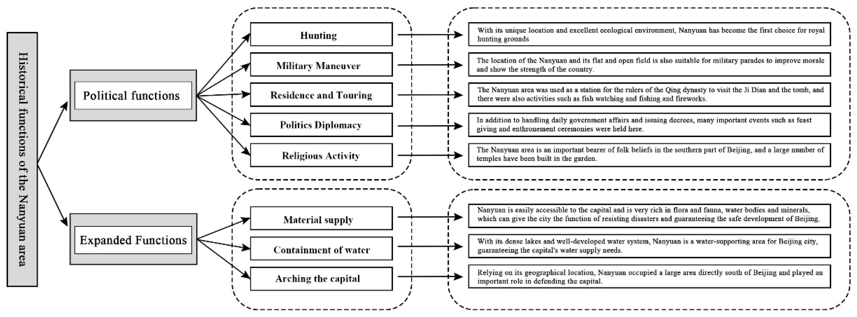
- Regarding the cognitive dimension, it took a macro-perspective to comprehensively examine the evolution laws of the regional land use patterns and unique historical and cultural value and to clarify the driving factors. Specifically, drawing on the World Heritage Committee’s criteria for the categorization of different cultural landscapes [32,33], and combining China’s cultural landscape types with the characteristics of the Nanyuan Airport area, the cultural landscape elements were divided into natural and cultural factors.
- (2)
- Regarding the practical dimension, through the analysis of land use changes and land simulation data, it paid attention to relevant land use features and strategies and discussed methods to maintain the overall spatial pattern characteristics and highlight the multi-layered historical spatial network of the region.
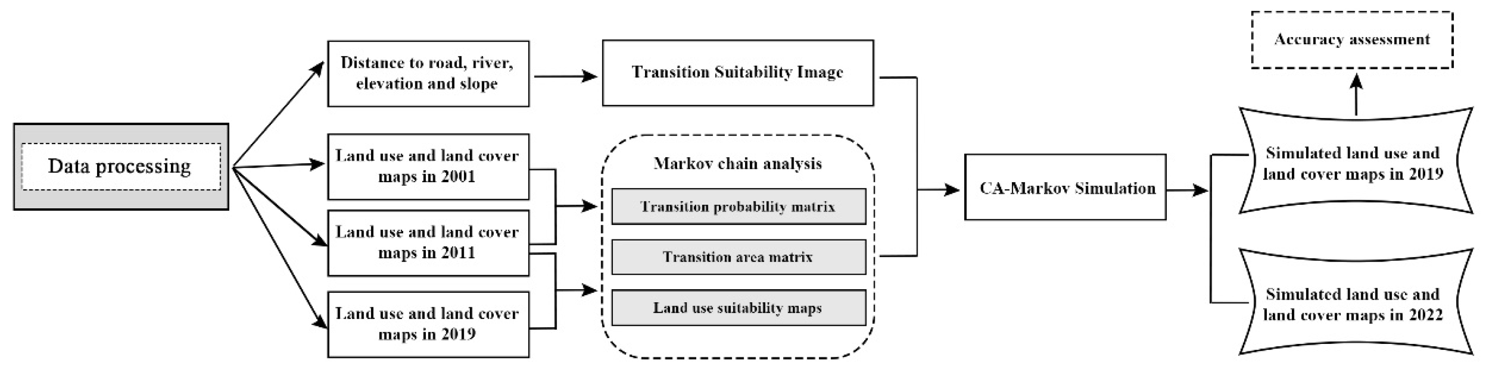
3.2. LUCC Detection and Simulation
3.2.1. Classification of Land Use Types and Testing
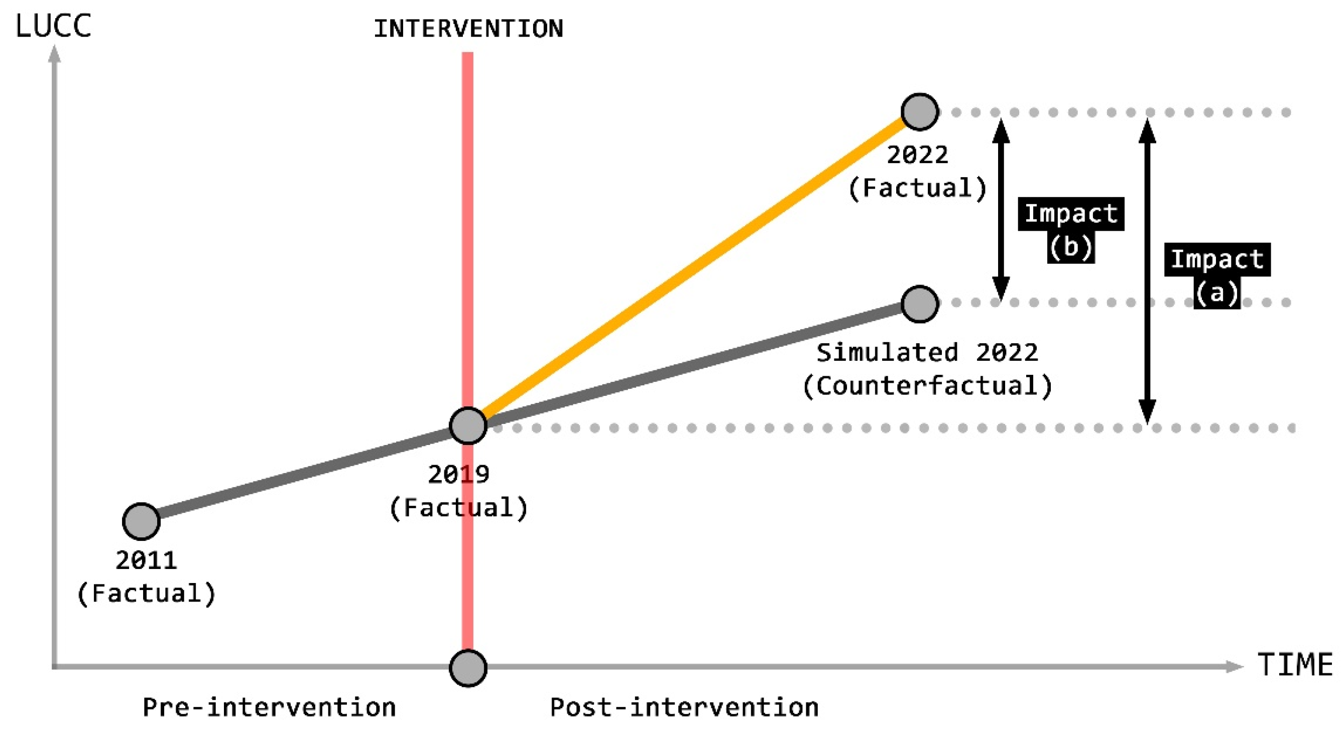
3.2.2. Simulation and Counterfactual Simulation Analysis Using the CA-Markov Model
3.3. Research Framework
4. Result
4.1. Evolution of Land Use Patterns and Development of Historic Urban Landscape Elements in the Nanyuan Airport Study Area
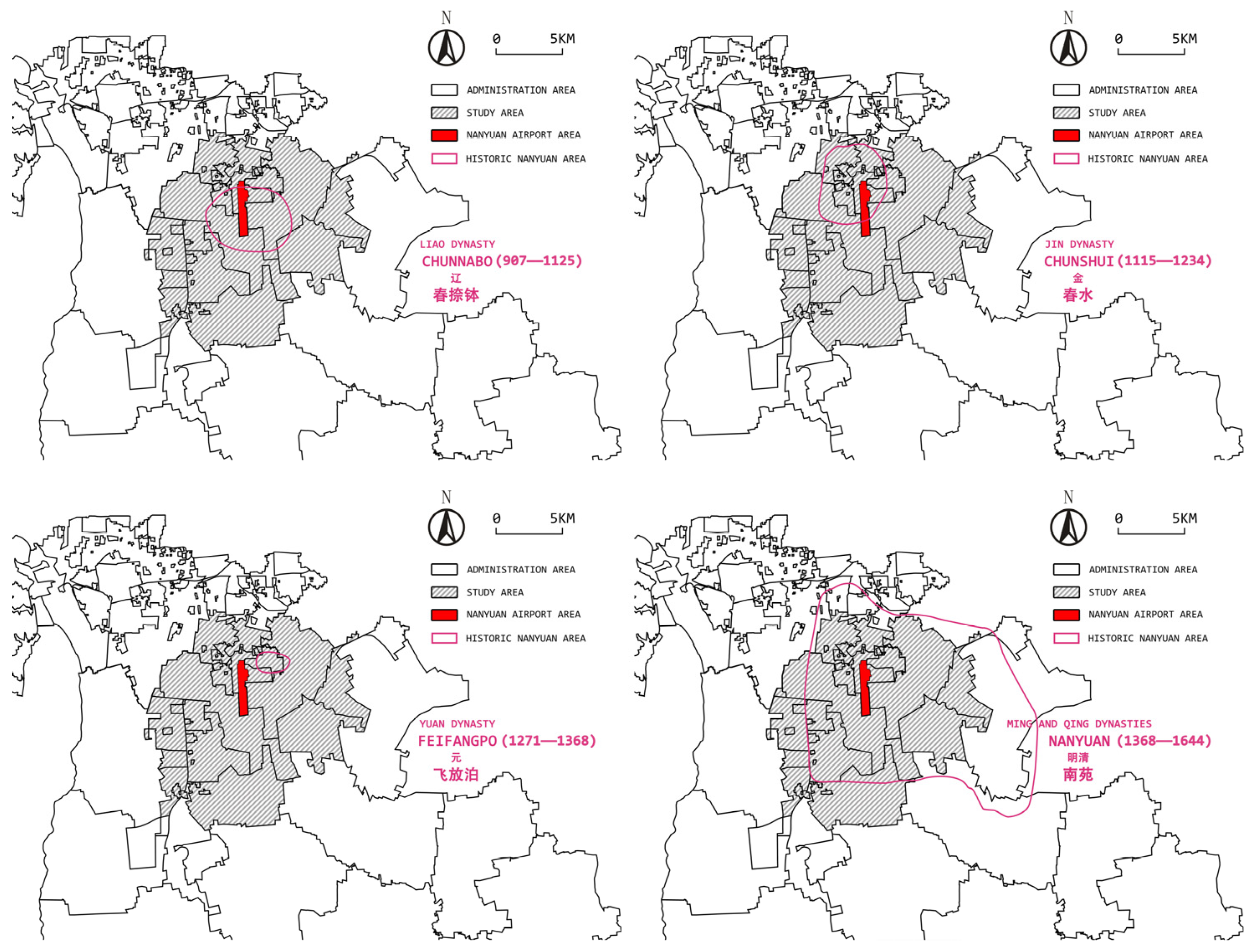
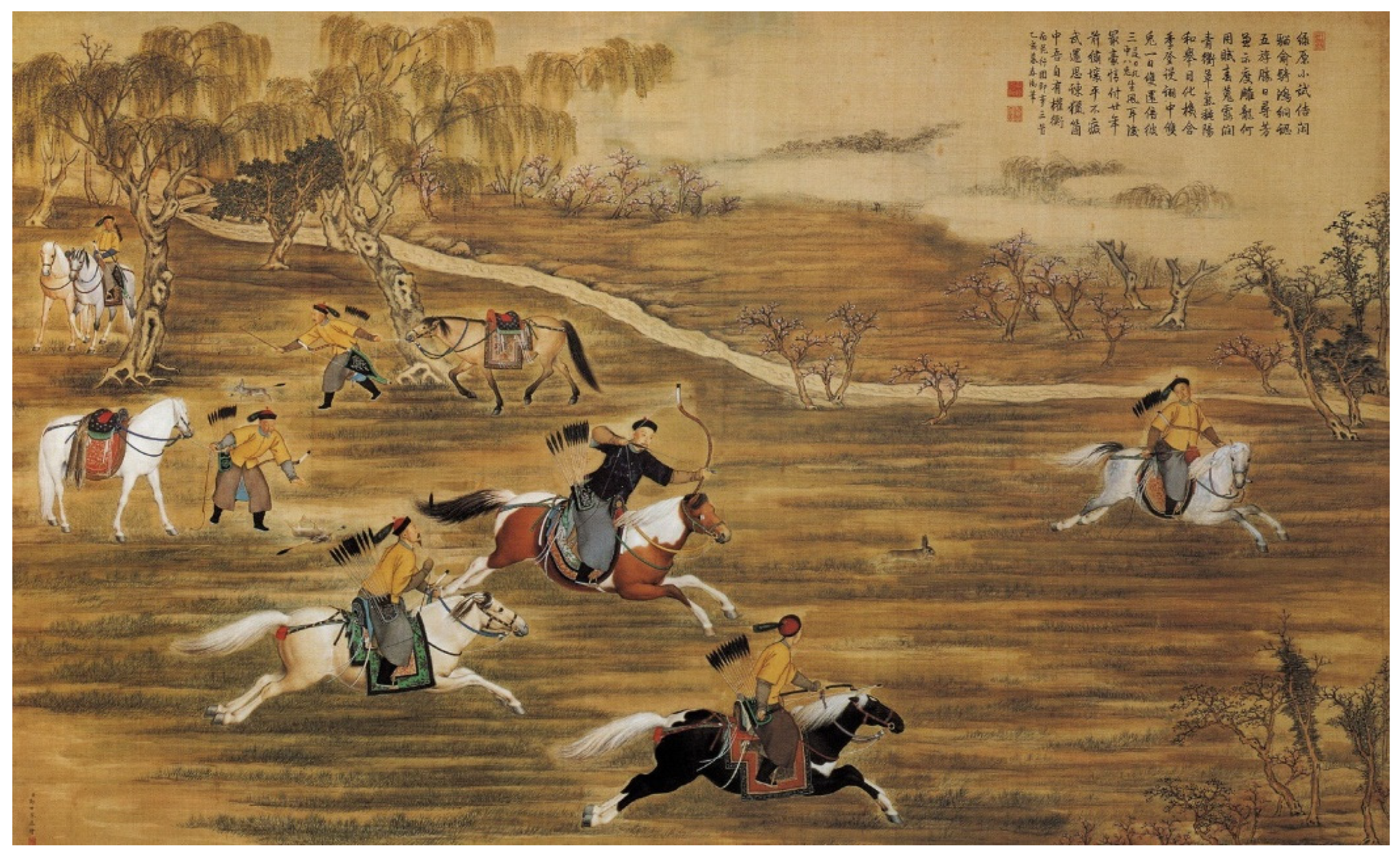
4.1.1. Budding Period: Following Nature (Liao and Jin Periods)
4.1.2. Period of Development: Delineation of Boundaries (Yuan Period)
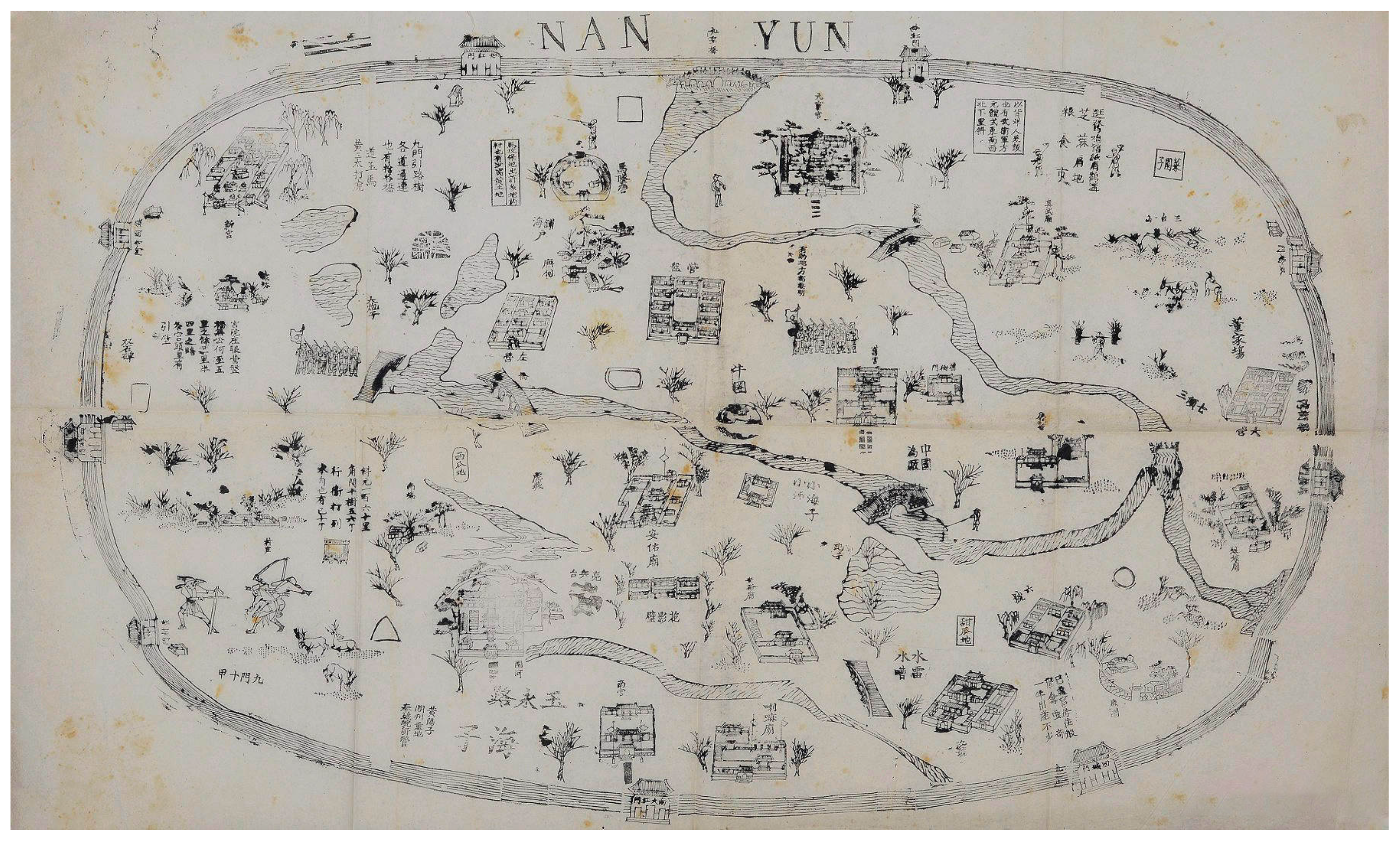
4.1.3. Maturity: Gradually Perfected (Ming and Qing Dynasties)
4.1.4. Decline: War-Torn (Modern Period)
4.1.5. Comparative Analysis of Land Use and Historic Urban Landscapes
- (1)
- The history of the development and evolution of the greater Nanyuan area is not a single fragment but encompasses long phases from the Liao, Jin, Yuan, Ming, Qing, and Republican periods to the present day, with a cultural fault emerging today. Through the construction of hunting grounds and parade grounds during the Liao and Jin dynasties, a solid foundation was laid for the development of the Nanyuan region, and the embryonic form of the historical urban landscape of Nanyuan emerged. With the delineation of the Nanyuan area during the Yuan dynasty, the historical urban landscape of Nanyuan took shape. Through the construction of the imperial hunting grounds during the Ming and Qing dynasties, as well as the decline of the Qing dynasty and the anti-aggression wars, the ancient historical urban landscape of Nanyuan matured, declined, and eventually came to an end, with the basic pattern of the ancient historical landscape of Nanyuan no longer existing. Finally, the Nanyuan region became a military stronghold on the modern outskirts of Beijing, an experimental site for railway and transportation, and the location of China’s first military and civilian airport, leading to the development of the modern cultural landscape of Nanyuan.
- (2)
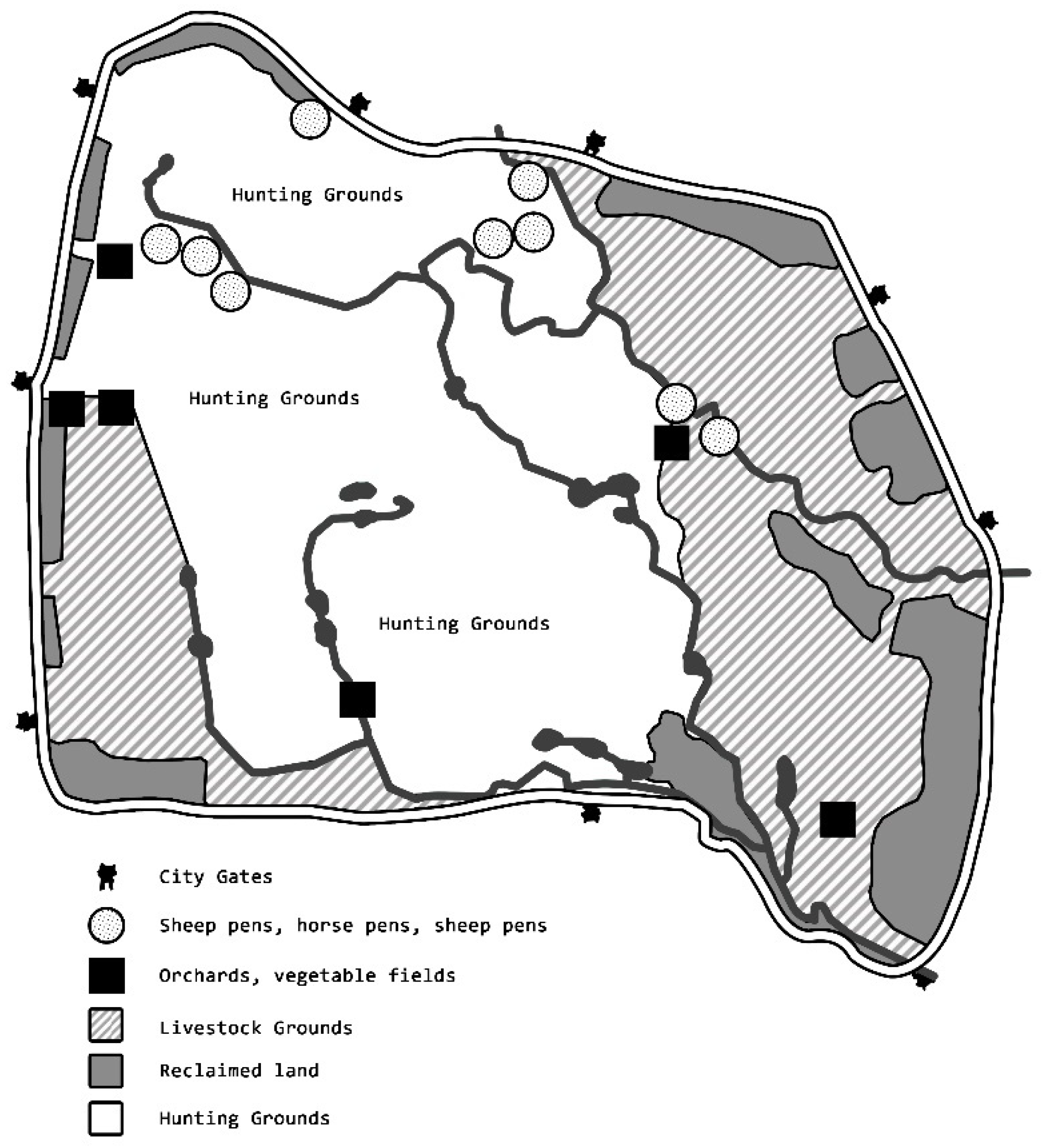
- The cultural and geographical characteristics of the Nanyuan area have allowed the region to retain the essential characteristics of the “garden” in terms of land use patterns in ancient China. Unlike other large royal gardens, the management of Nanyuan by successive rulers was slow to develop and the scale of construction was minimal, with a maximum building density of around 0.027% [54]. Even when the treasury was full at the time of the Qianlong event, only two new buildings were built. This is a direct reflection of the non-architectural nature of the construction of Nanyuan, which was rooted in the nomadic culture of hunting and the tradition of martial discipline. Furthermore, because of the Nanyuan area’s natural wetland environment and its privileged location south of the Forbidden City, Nanyuan evolved throughout the Liao and Qing dynasties, retaining almost all of the ancient functions of a garden, such as hunting and military parades, material production, and resource supply reserves, and it has remained close to the original meaning of ‘garden’ in ancient China.
- (3)
- Land use and management in Nanyuan was based on an ecological foundation and focused on holistic thinking. The Ming and Qing capitals were not confined to the old city but were built in a wider area to construct a fully functional capital system. As a wetland, the management goals in Nanyuang were mainly based on ecological foundations and were adapted to the local conditions, with hunting, martial arts, and gardening as the mainstay, supplemented by material supply and ecological nourishment, so that it gave full play to the urban and ecological functions as an important part of the capital’s functional system. As a result, Nanyuan has developed over a long period of time, interacting with the production and social structure of the capital, forming a unique spatial pattern and cultural system, and maintaining a high degree of integrity and complementarity with the functions and space of the capital.
- (4)
- There is a correlation between the land management of Nanyuan and the landscape character of the area. The landscape and economic benefits were controlled by adjusting the land use types and crop cultivation. Nanyuan was largely self-sufficient in its financial policies, except for the additional funds that it had to draw on from the Ministry of Finance [55]. However, the land within Nanyuan was not developed in an uncontrolled manner to meet financial needs, and, each year, the number of acres in Nanyuan is re-evaluated and adjusted. There are always acres that are continually reclaimed, as well as ripe land that is abandoned and converted into hunting grounds, ensuring a certain level of productive activity while the area’s landscape is maintained, and the land use is always well proportioned and coordinated.
4.2. Land Use and Land Cover Change Dynamics
4.2.1. Classification of Land Use and Accuracy Assessment of Land Modeling
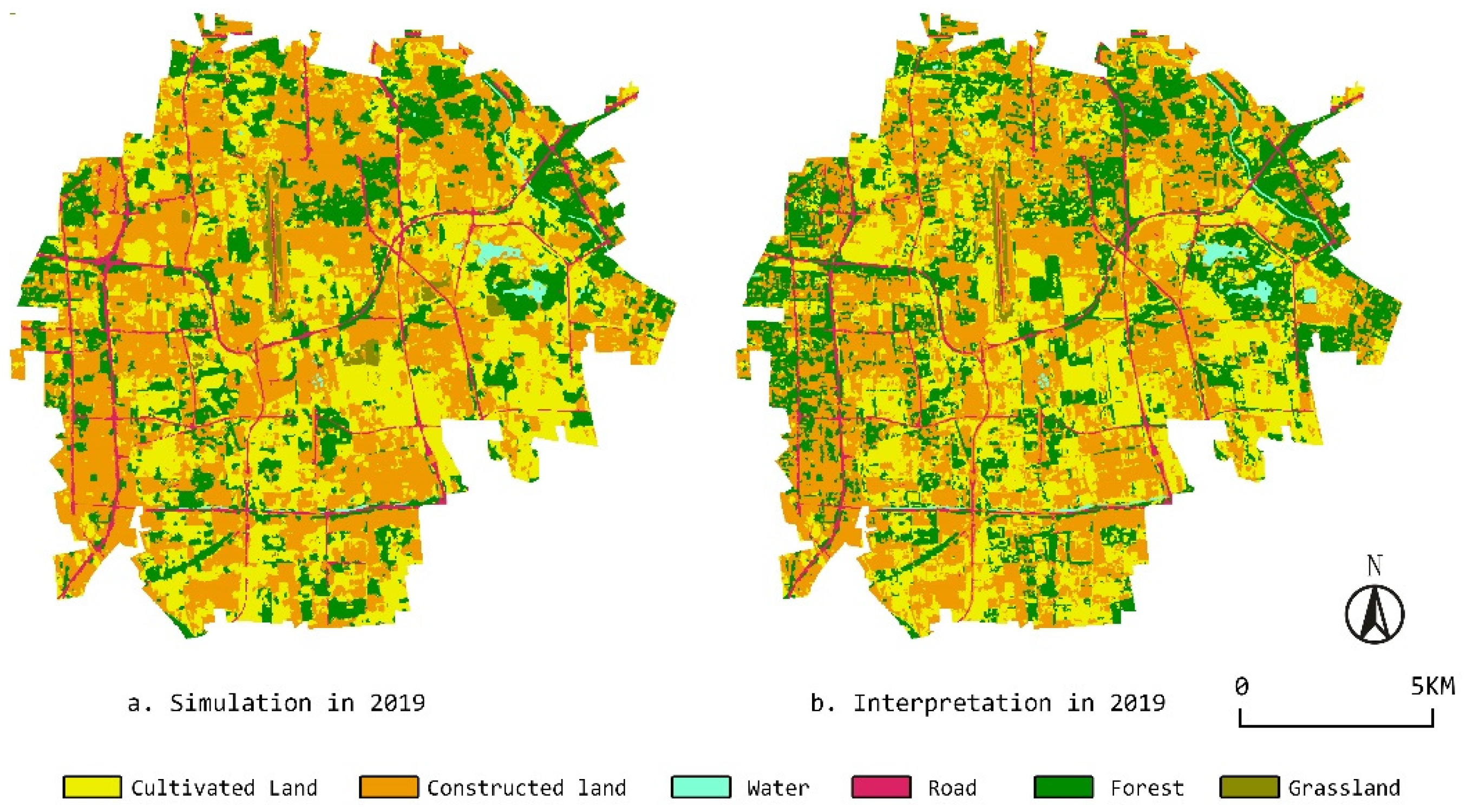
4.2.2. Land Use and Land Cover Classification and Simulation Results
4.2.3. Interrelationships, Mechanistic Features, and Causes within and outside the Airport
- (1)
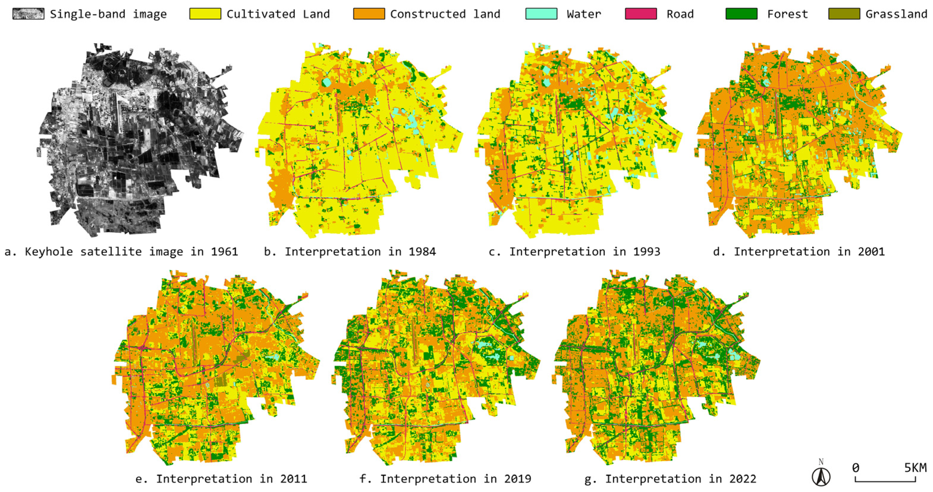
- Over its long history, Nanyuan Airport has had a profound influence on the basic pattern and landscape character of the site. Throughout the research period, the frequent conversion of cultivated land to constructed land was a major feature of the land use change during the study period. Since the construction of the airport, the land use of the airport itself and its surrounding areas has been influenced by territorial effects and aviation externalities, resulting in disruptions to ground transportation networks, impediments to urban development, spatial distortions in the urban structure around the airport, and the formation of noise landscapes characterized by agriculture, infrastructure, or low-density areas within the noise contour lines [2]. Furthermore, the study region has been impacted by population and economic expansion, as well as other land use policies and decisions. In the survey, we can see that the study region has witnessed drastic land use changes since 1984, as illustrated in Figure 13. This transformation can also be found to have persisted to some extent to the current day, with the related environmental and cultural influences leaving an indelible mark on the area.
- (2)
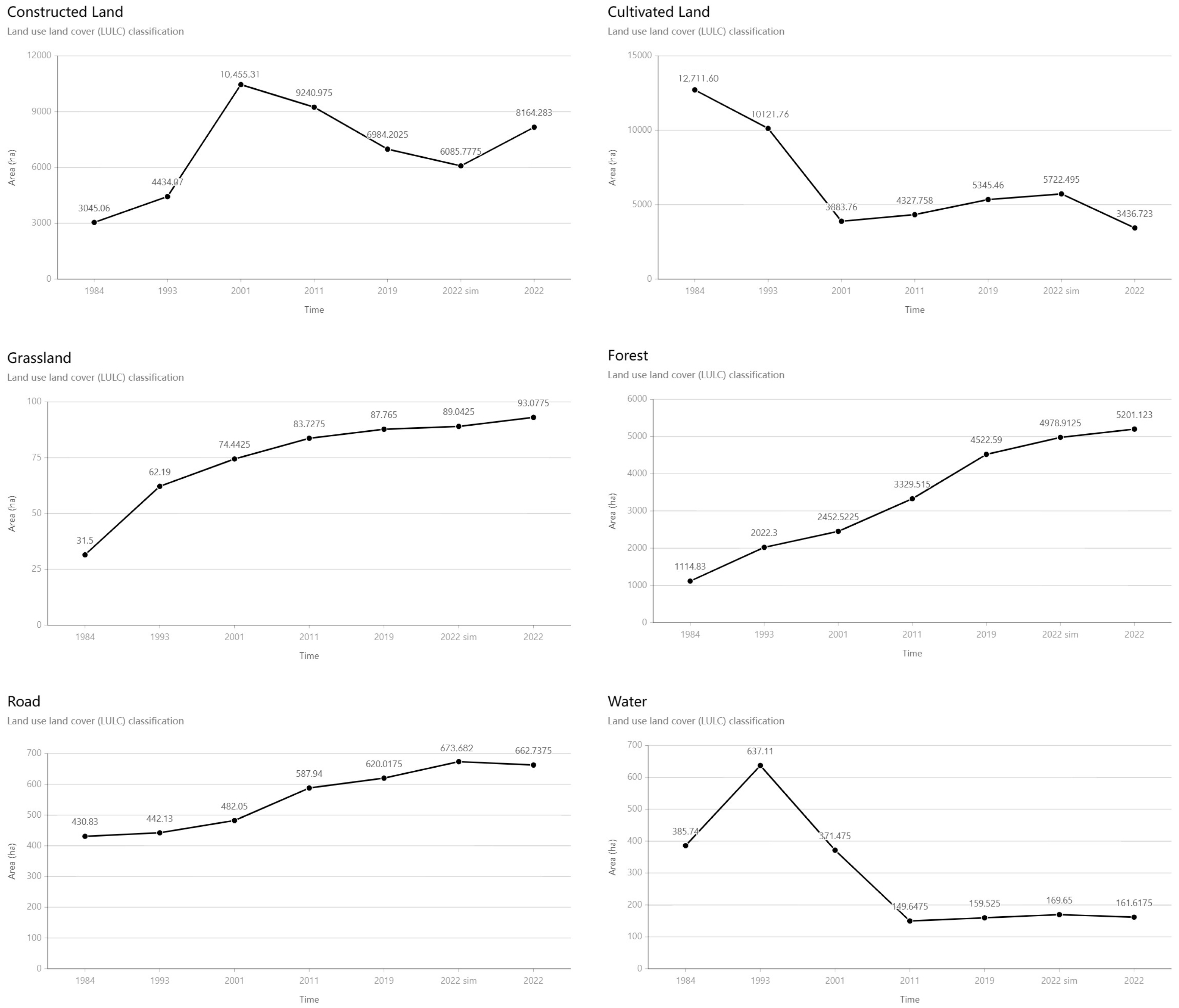
- The construction and development of Nanyuan Airport, as well as the degree of urbanization in the surrounding area, had a one-of-a-kind influence on the land use patterns. According to the data, the degree of urbanization around the airport was relatively low between 1984 and 2001, and the airport had recently been converted from a military to a civilian–military airport, with a reduced capacity; thus, it had less of an urbanizing effect on the surrounding area, as shown in Figure 13 and Figure 14, which depict a typical urbanization pattern. However, during the period 2001–2011, Nanyuan Airport experienced the resumption of flights and the renovation and expansion of the terminal building, which greatly increased the number of flights carried and the scope of the airport’s influence on the surrounding area increased. The economic or traffic locations around the airport may have been rebuilt as a result. At the same time, the urbanization of the surrounding area reached a new stage, resulting in a reduction in the amount of land available for construction during this period and an increase in the amount of cultivated land. After the airport’s shutdown in 2019, many urban development restrictions were lifted, and, in only three years, the amount of constructed land grew significantly, while cultivated land declined rapidly. Although we cannot quantify how much of the fluctuation in the amount of different land uses is due to physical or urban effects from the airport’s closure versus other land policies, the land simulation results definitively demonstrate the influences imposed by the airport on its surroundings. It is clear that urbanization and population growth, as well as the strong demand for new housing and the physical position of the study area in Beijing’s south central axis, have increased the rate of land use reconversion to new urban development and urban parks. The airport’s shutdown has created a new opportunity for local development.
- (3)
- China’s specific land policies have led to particularities in the changing land use patterns in and around Beijing’s Nanyuan Airport. The substantial increase in forest land use within the research area is attributed to various policies implemented by the Chinese government, ranging from the 1981 Resolution on Compulsory Tree Planting for the Whole Country to the National Forest City Construction Policy [74]. These policies have facilitated the expansion of forest land through extensive land clearance and reclamation efforts. At the same time, the government’s absolute power in construction has also been applied to the airport and its surroundings. For example, the expropriation of farmland near airports involves China’s land policy on balancing the occupation and compensation of cultivated land (gengdi zhanbu pingheng, CLRCQ) [75], which is the process of supplying an equivalent amount and quality of cultivated land to local governments for the purpose of development. There is also a land acquisition system (tudi Zhengshou, LE) [76], in which local governments acquire land from farmers and residents for airport construction and then compensate them in a certain amount. On the one hand, the overall change in the airport’s construction is government-led, and, therefore, the maintenance of land development and land acquisition surrounding the airport is largely restricted by the government’s budgetary conditions. However, under a government-led land use mode, it is simpler to plan for land purchases, decommissioning, and future developments to the land around the airport.
5. Discussion
5.1. Connections
- (1)
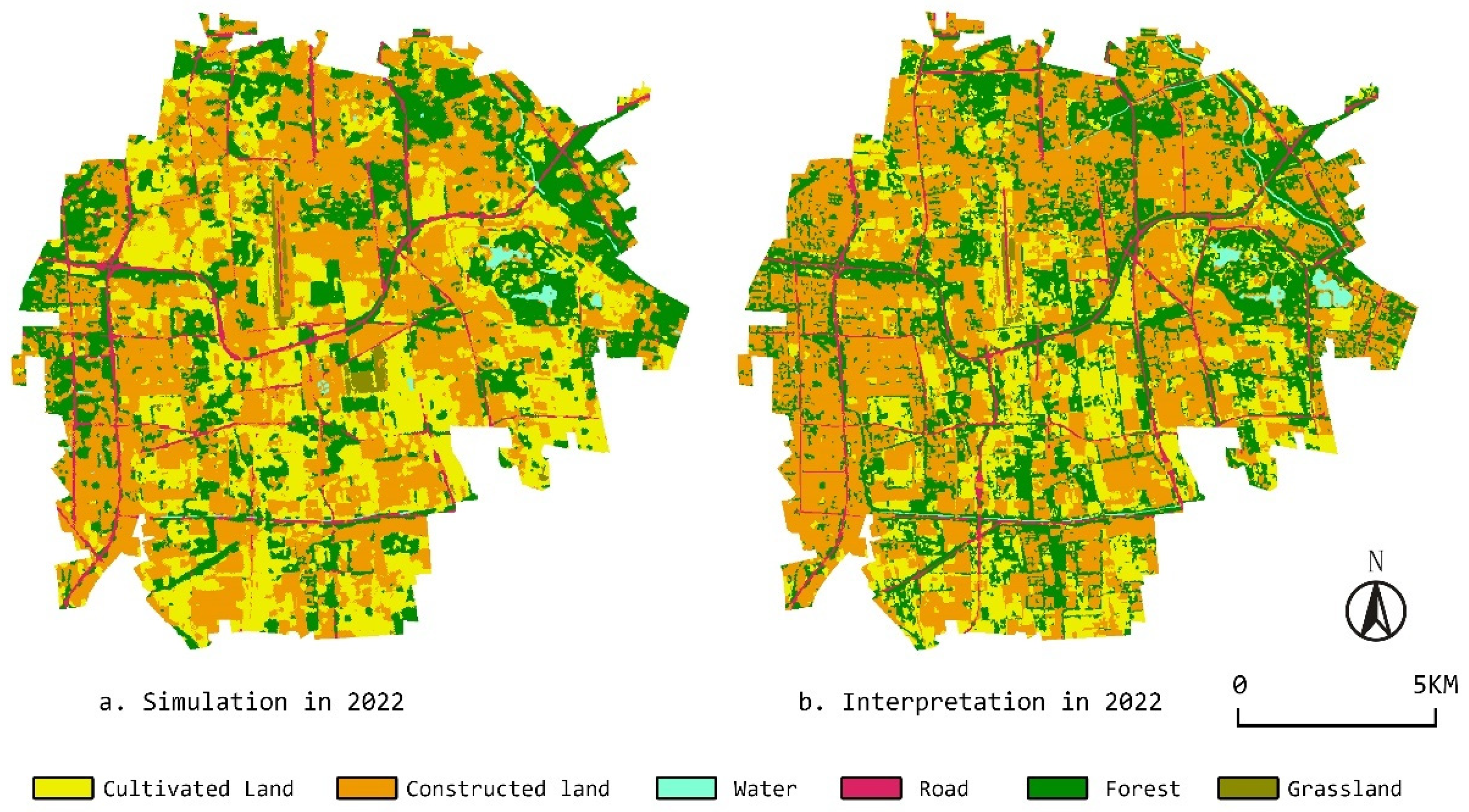
- Restore and strengthen the organic connection between the Nanyuan study area and the Beijing city proper. The Nanyuan study area should be restored as an important ecological functional zone in Southern Beijing. Through the historical stratification analysis, we can see that the Nanyuan area, as a direct extension of Beijing’s functions, has had the purpose of ecological protection since its inception. In the hundreds of years of construction that followed, it maintained the minimum level of architectural construction and resource extraction. The Nanyuan wetlands once greatly replenished Beijing’s groundwater [78], but, due to the cut-off of the Yongding River and land reclamation, the wetlands no longer exist, impacting Beijing’s groundwater levels. At the same time, Beijing’s urban spatial pattern of “northern mountains and southern waters, northern culture and southern martial arts” carries the city’s own cultural memory and historical heritage, and restoring the overall wetland ecological pattern will benefit the continuation and development of Beijing’s future urban context. On the other hand, through land use classification and simulation, we found that in only three years, from 2019 when Nanyuan Airport ceased operations to 2022, construction land increased rapidly with the high land use demand, especially in the west, north, and northeast of Nanyuan Airport, with the total area expanding from 6984.20 hectares to 8164.28 hectares (+16.90%). According to the counterfactual simulation results, the actual distribution of agricultural land is more fragmented. Although our research shows that the airport’s shutdown has provided the locality with a brand new development opportunity, the primary focus of current planning should be on constructing a diversified spatial planning system, optimizing the land use structure, and scientifically and rationally resolving the contradiction between the growth of construction land and the protection of agricultural land. Considering the protection of the existing urban fabric, the appropriate promotion of the decentralization of non-capital functions and population control, the implementation of spatial integration and ecological restoration, and the focused shaping of existing ecological landscape areas such as Nanyuan Forest Park, as the core area of Nanyuan’s landscape, are necessary to build an urban ecological network of “ecological zones–ecological corridors–ecological nodes”.
- (2)
- Reinforce the linkages between Nanyuan’s aviation cultural landscape, ancient Nanyuan’s cultural landscape, and other historical urban landscapes. Our HUL analysis found that Nanyuan maintained the fundamental features of the garden landscapes seen throughout ancient Chinese history, albeit with extremely gradual construction. Meanwhile, our LUCC analysis revealed monumental overall pattern changes since 1961 as the dominant land use shifted from agricultural to construction land, with Nanyuan Airport exerting a major influence on local land use models, as shown in Figure 13. These combined methods indicate that the research area currently suffers from severe cultural discontinuity. From the HUL perspective, culture-based urban development patterns are crucial for sustainable cities in the post-industrial era. As the epitome of the ancient Chinese central axes, the central axis at which the research area lies constitutes an important component of the city’s cultural and historical heritage. Some scholars have pointed out that, since modern times, natural advantages evolved into human-driven forces as the foremost influences on central axis development and conservation in Beijing, often neglecting natural elements like overall landscape patterns. As an integral part of the southern central axis, the research area should respond to the extant aviation culture by reviving the ancient Nanyuan landscape and royal garden culture from five dynasties ago, along with traditional historical folk culture. Hence, during replanning, overall continuity and unity should be considered, unifying the “history”, “present”, and “future” within the Nanyuan context. Microscopically, methods like linking and weaving could incorporate historical zones, paths, and nodes with local production, society, economy, and nature into an integrated network. Additionally, the hierarchical relationships between cultural landscape developments across different levels and dimensions warrant further research and refinement.
5.2. Development Engines
- (1)
- Fully harness the physical value of the research area as a tangible engine for development. The innate physical attributes of Nanyuan Airport itself, including its scale, leftover infrastructure, and advantageous geographical location, are invaluable for the transformation and renewal of the Nanyuan urban zone. Our analysis of the land use surrounding Nanyuan Airport shows that the research area’s environs are undergoing rapid urbanization, with a sizable population close to the city center, resulting in favorable development conditions that could support the redevelopment of the airport site. Notably, our findings indicate that China’s unique land policies, such as the cultivated land occupancy compensation balance policy and land requisition system, also provide support for functional upgrades in the research area, albeit with some constraints, since maintaining land development around the airport and expropriation will be largely limited by governmental fiscal conditions. Moreover, based on our exploration of Nanyuan’s historical stratum, we find that the research area’s ecological ethos stemming from ancient Chinese garden appreciation awaits revival, in line with modern ecological leisure concepts. Hence, rather than rebuilding the airport into a new residential form or regarding it as an ordinary abandoned site by completely erasing its physical features, we believe that the Nanyuan Airport ruins should be considered as latent reserves for green and public spaces on Beijing’s southern central axis. Specifically, adaptive reuse could transform it into a “cultural creative industry park and civic ecological park”, making it an important leisure, recreation, and creative exhibition space for Beijing’s southern region. Meanwhile, the areas surrounding Nanyuan Airport could also capitalize on their advantageous geographical location, taking the southern central axis as the guiding principle and blue–green ecological spaces as the foundation. Making full use of existing airport leftovers like rail transport and road infrastructure to construct high-quality urban service areas would serve to narrow the development gaps between Beijing’s northern and southern zones to achieve sustainable growth, fulfilling the site’s developmental attributes while controlling fiscal expenditures.
- (2)
- Fully harness the research area’s inherent cultural value as an intangible engine for development. Unlike other airports, Nanyuan Airport has amassed diverse value and uniqueness through its centuries of evolution, with different eras of usage, aesthetics, and technical history. Likewise, the Nanyuan research area has undergone geographical landscape transformations, from royal gardens abundant in rivers, lakes, and springs to expansive farmland and clustered villages, which would also precipitate corresponding shifts in place identity. The sense of place emerging from human–space interactions and the associated emotional attachments stem fundamentally from the distinctive relationships between people and settings following cultural and social metamorphoses [19,79]. Thus, strong local identity facilitates regional sustainable development and forms associated local characteristics, propelling the area’s further advancement. Consequently, the Nanyuan research area’s urban development necessitates addressing the issue of urban homogenization, requiring the Daxing and Fengtai district governments to collaborate in constructing an integrated local cognition as the basis for new urban planning and development, thereby safeguarding the region’s historical continuity and ensuring that residents have accurate perceptions of Nanyuan’s distinct traits.
6. Conclusions
Author Contributions
Funding
Data Availability Statement
Acknowledgments
Conflicts of Interest
References
- Salewski, C.; Boucsein, B.; Gasco, A. Towards an effect-based model for airports and cities. In Airports, Cities and Regions; Routledge: Oxfordshire, UK, 2014; pp. 271–295. [Google Scholar]
- Gasco, A. The Airport and the Territory: Cross-Border Urbanism in the Singapore-Johor-Riau Tri-National Region; ETH Zurich: Zurich, Switzerland, 2015. [Google Scholar]
- Favargiotti, S. Renewed landscapes: Obsolete airfields as landscape reserves for adaptive reuse. J. Landsc. Archit. 2018, 13, 90–100. [Google Scholar] [CrossRef]
- Freestone, R.; Baker, D. Spatial planning models of airport-driven urban development. J. Plan. Lit. 2011, 26, 263–279. [Google Scholar] [CrossRef]
- Thierstein, A.; Conventz, S. Hub Airports, the Knowledge Economy and How Close Is Close? Evidence from Europe; European Regional Science Association (ERSA): Wallonia, Belgium, 2014. [Google Scholar]
- Song, K.-H.; Suh, W. Perceptions on Regional Benefit of Airport Development and Operation. Appl. Sci. 2022, 12, 4340. [Google Scholar] [CrossRef]
- Pi, J.; Li, D.; Liu, X.; Freestone, R. The spatial distribution of employment around major Chinese airports. J. Transp. Geogr. 2021, 91, 102978. [Google Scholar] [CrossRef]
- He, C.; Zhang, J.; Liu, Z.; Huang, Q. Characteristics and progress of land use/cover change research during 1990–2018. J. Geogr. Sci. 2022, 32, 537–559. [Google Scholar] [CrossRef]
- Wang, J.; Bretz, M.; Dewan, M.A.A.; Delavar, M.A. Machine learning in modelling land-use and land cover-change (LULCC): Current status, challenges and prospects. Sci. Total Environ. 2022, 822, 153559. [Google Scholar] [CrossRef]
- Swangjang, K.; Iamaram, V. Change of land use patterns in the areas close to the airport development area and some implicating factors. Sustainability 2011, 3, 1517–1530. [Google Scholar] [CrossRef]
- Xiong, C.; Beckmann, V.; Tan, R. Effects of infrastructure on land use and land cover change (LUCC): The case of Hangzhou International Airport, China. Sustainability 2018, 10, 2013. [Google Scholar] [CrossRef]
- Yang, L.; Wang, J.-L.; Zhou, W.-Q. Coupling evolution analysis of LUCC and habitat quality in Dongting Lake Basin Based on multi-scenario simulation. China Environ. Sci. 2023, 43, 863–873. (In Chinese) [Google Scholar]
- Li, J.; Ouyang, X.; Zhu, X. Land space simulation of urban agglomerations from the perspective of the symbiosis of urban development and ecological protection: A case study of Changsha-Zhuzhou-Xiangtan urban agglomeration. Ecol. Indic. 2021, 126, 107669. [Google Scholar] [CrossRef]
- Liu, X.W.; Chen, B.M.; Shi, X.Z. A Review of The Research on Land Use and Land Cover Change in China. Soils 2017, 36, 132–135+140. (In Chinese) [Google Scholar]
- Wang, Q.; Guan, Q.; Sun, Y.; Du, Q.; Xiao, X.; Luo, H.; Zhang, J.; Mi, J. Simulation of future land use/cover change (LUCC) in typical watersheds of arid regions under multiple scenarios. J. Environ. Manag. 2023, 335, 117543. [Google Scholar] [CrossRef] [PubMed]
- Ginzarly, M.; Houbart, C.; Teller, J. The Historic Urban Landscape approach to urban management: A systematic review. Int. J. Herit. Stud. 2019, 25, 999–1019. [Google Scholar] [CrossRef]
- Bandarin, F.; Van Oers, R. The Historic Urban Landscape: Managing Heritage in an Urban Century; John Wiley & Sons: Hoboken, NJ, USA, 2012. [Google Scholar]
- Gu, X.Y. The Importance of Historic Layer Analysis to Urban Space Identity: Based on the Concept and Approach of Historic Urban Landscape. Urb. Arch. 2016, 4, 41–44. (In Chinese) [Google Scholar]
- Jiang, J.; Zhou, T.; Han, Y.; Ikebe, K. Urban heritage conservation and modern urban development from the perspective of the historic urban landscape approach: A case study of Suzhou. Land 2022, 11, 1251. [Google Scholar] [CrossRef]
- Rey-Pérez, J.; Pereira Roders, A. Historic urban landscape: A systematic review, eight years after the adoption of the HUL approach. J. Cult. Herit. Manag. Sustain. Dev. 2020, 10, 233–258. [Google Scholar] [CrossRef]
- Azpeitia Santander, A.; Azkarate Garai-Olaun, A.; De la Fuente Arana, A. Historic urban landscapes: A review on trends and methodologies in the urban context of the 21st century. Sustainability 2018, 10, 2603. [Google Scholar] [CrossRef]
- Erkan, Y. The Way Forward with Historic Urban Landscape Approach towards Sustainable Urban Development. Built Herit. 2018, 2, 82–89. [Google Scholar] [CrossRef]
- Roseau, N. Airports as urban narratives: Toward a cultural history of the global infrastructures. Transfers 2012, 2, 32–54. [Google Scholar] [CrossRef]
- Redding, S.J.; Sturm, D.M.; Wolf, N. History and industry location: Evidence from German airports. Rev. Econ. Stat. 2011, 93, 814–831. [Google Scholar] [CrossRef]
- Shi, L. Nan Yuan Ji Chang De Zhu Duo Di Yi [Many firsts for Nanyuan Airport]. Jetliner 2019, 4. (In Chinese) [Google Scholar]
- Zhao, X.H. Beijing Yuan Lin Shi Hua [Historical Stories of Beijing Gardens]; China Forestry Press: Beijing, China, 1994. (In Chinese) [Google Scholar]
- Zhou, W. The History of Classical Chinese Garden; Beijing Tsinghua University Press: Beijing, China, 2008. [Google Scholar]
- Xiao, Y.; Liu, L. Royal Land Use and Management in Beijing in the Qing Dynasty. Land 2021, 10, 1093. [Google Scholar] [CrossRef]
- Xiao, Y.; Zhu, Q.; Zhuo, K.F. Plant Landscape and Management System of Beijing Royal Gardens, Qing Dynasty. Landsc. Archit. 2018, 25, 110–115. (In Chinese) [Google Scholar]
- Chen, Z. Airport Surrounding Area Development in China. Ph.D. Thesis, University of Illinois, Urbana, IL, USA, 2020. [Google Scholar]
- Zhang, J.; Shang, Y.; Li, Q.; Zhang, S.; Xiao, J.; Li, M. Inheritance and Development: Study on the Overall Management and Control Strategies of the North–South Extension of Central Axis of Beijing. Sustainability 2021, 13, 4809. [Google Scholar] [CrossRef]
- Taylor, K.; Altenburg, K. Cultural landscapes in Asia-Pacific: Potential for filling world heritage gaps. Int. J. Herit. Stud. 2006, 12, 267–282. [Google Scholar] [CrossRef]
- Fowler, P. World Heritage Cultural Landscapes, 1992–2002: A Review and Prospect; Cultural Landscapes: The Challenges of Conservation; UNESCO World Heritage Center: Paris, France, 2002; p. 16. [Google Scholar]
- Letsoin, S.M.A.; Herak, D.; Purwestri, R.C. Evaluation Land Use Cover Changes Over 29 Years in Papua Province of Indonesia Using Remote Sensing Data. IOP Conf. Ser. Earth Environ. Sci. 2022, 1034, 012013. [Google Scholar] [CrossRef]
- Tang, G.-L.; Zhou, M.-C.; Feng, W.; Ma, Z. Multiscale Analysis of Remote Sensing Data for LUCC Detection. Remote Sens. Technol. Appl. 2011, 20, 581–585. [Google Scholar]
- Deng, X.; Li, Z. A review on historical trajectories and spatially explicit scenarios of land-use and land-cover changes in China. J. Land Use Sci. 2016, 11, 709–724. [Google Scholar] [CrossRef]
- Li, J.; Dai, T.; Yin, S.; Zhao, Y.; Kaya, D.I.; Yang, L. Promoting conservation or change? The UNESCO label of world heritage (re) shaping urban morphology in the Old Town of Lijiang, China. Front. Archit. Res. 2022, 11, 1121–1133. [Google Scholar] [CrossRef]
- Rujoiu-Mare, M.-R.; Mihai, B.-A. Mapping land cover using remote sensing data and GIS techniques: A case study of Prahova Subcarpathians. Procedia Environ. Sci. 2016, 32, 244–255. [Google Scholar] [CrossRef]
- Lillesand, T.; Kiefer, R.W.; Chipman, J. Remote Sensing and Image Interpretation; John Wiley & Sons: Hoboken, NJ, USA, 2015. [Google Scholar]
- Arsanjani, J.J.; Helbich, M.; Kainz, W.; Boloorani, A.D. Integration of logistic regression, Markov chain and cellular automata models to simulate urban expansion. Int. J. Appl. Earth Obs. Geoinf. 2013, 21, 265–275. [Google Scholar] [CrossRef]
- Guan, D.; Li, H.; Inohae, T.; Su, W.; Nagaie, T.; Hokao, K. Modeling urban land use change by the integration of cellular automaton and Markov model. Ecol. Model. 2011, 222, 3761–3772. [Google Scholar] [CrossRef]
- Yirsaw, E.; Wu, W.; Shi, X.; Temesgen, H.; Bekele, B. Land use/land cover change modeling and the prediction of subsequent changes in ecosystem service values in a coastal area of China, the Su-Xi-Chang Region. Sustainability 2017, 9, 1204. [Google Scholar] [CrossRef]
- Jiang, G.; Zhang, F.; Kong, X. Determining conversion direction of rural residential land consolidation in Beijing mountainous areas. Trans. Chin. Soc. Agric. Eng. 2009, 25, 214–221. [Google Scholar]
- Sang, L.; Zhang, C.; Yang, J.; Zhu, D.; Yun, W. Simulation of land use spatial pattern of towns and villages based on CA–Markov model. Math. Comput. Model. 2011, 54, 938–943. [Google Scholar] [CrossRef]
- Tariq, A.; Yan, J.; Mumtaz, F. Land change modeler and CA-Markov chain analysis for land use land cover change using satellite data of Peshawar, Pakistan. Phys. Chem. Earth A B C 2022, 128, 103286. [Google Scholar] [CrossRef]
- Tattoni, C.; Ciolli, M.; Ferretti, F. The fate of priority areas for conservation in protected areas: A fine-scale Markov chain approach. Environ. Manag. 2011, 47, 263–278. [Google Scholar] [CrossRef]
- Wang, S.Q.; Zheng, X.; Zang, X. Accuracy assessments of land use change simulation based on Markov-cellular automata model. Procedia Environ. Sci. 2012, 13, 1238–1245. [Google Scholar] [CrossRef]
- Pontius, R.G., Jr.; Schneider, L.C. Land-cover change model validation by an ROC method for the Ipswich watershed, Massachusetts, USA. Agric. Ecosyst. Environ. 2001, 85, 239–248. [Google Scholar] [CrossRef]
- Wu, F. Calibration of stochastic cellular automata: The application to rural-urban land conversions. Int. J. Geogr. Inf. Sci. 2002, 16, 795–818. [Google Scholar] [CrossRef]
- Ghalehteimouri, K.J.; Shamsoddini, A.; Mousavi, M.N.; Ros, F.B.C.; Khedmatzadeh, A. Predicting spatial and decadal of land use and land cover change using integrated cellular automata Markov chain model based scenarios (2019–2049) Zarriné-Rūd River Basin in Iran. Environ. Chall. 2022, 6, 100399. [Google Scholar] [CrossRef]
- Magliocca, N.R.; Dhungana, P.; Sink, C.D. Review of counterfactual land change modeling for causal inference in land system science. J. Land Use Sci. 2023, 18, 1–24. [Google Scholar] [CrossRef]
- Lebow, R.N. What’s so different about a counterfactual? World Politics 2000, 52, 550–585. [Google Scholar] [CrossRef]
- He, J.; Liu, Y.; Yu, Y.; Tang, W.; Xiang, W.; Liu, D. A counterfactual scenario simulation approach for assessing the impact of farmland preservation policies on urban sprawl and food security in a major grain-producing area of China. Appl. Geogr. 2013, 37, 127–138. [Google Scholar] [CrossRef]
- Wang, J.; Li, Y.X.; Zhang, Z.H. Da Li Shi Guan Yin Ling Gu Du Jiao Ye Te Se Di Qv Wen Mai Chuan Cheng Yu Fu Xing Yi Beijing Da Nan Yuan Qv Yu wei li [The Great Historical Perspective Leads to the Heritage and Revival of the Cultural Heritage of the Ancient Capital Countryside—The Great Nanyuan Area in Beijing as an Example]. China Anc. City 2020, 64–72. (In Chinese) [Google Scholar]
- Zhang, Y.J. A Study the Nan Yuan Imperial Garden in the Qing Dynasty in Beijing; Beijing Forestry University: Beijing, China, 2011. (In Chinese) [Google Scholar]
- Tian, Q.Y. The Study of NanYuan Paddock and the Fortunes of the Qing Dynasty; Northeast Normal University: Changchun, China, 2016. (In Chinese) [Google Scholar]
- Yang, Z.H. Liao dai chun nuo bo di kao [Study of the Chun-nuo-bo Region during the Liao Dynasty]. Heilongjiang Natl. Ser. 1989, 79–83. (In Chinese) [Google Scholar] [CrossRef]
- Yuwen, X.Z. Da Jin Guo Zhi Jiao Zheng Shang Ce [Annotated Records of the Great Jin Dynasty, Volume One]; Zhonghua Book Company: Shanghai, China, 1986. (In Chinese) [Google Scholar]
- Zhang, B.Q. Jin Shi Lun Gao Di Yi Juan [Drafts on the History of Jin, Volume One]; Jilin Wenshi Press: Changchun, China, 1986. [Google Scholar]
- Sun, M.T. Shun Tian Fu Zhi [Gazetteer of Shuntian Prefecture]; Beijing Guji Press: Beijing, China, 1983. (In Chinese) [Google Scholar]
- Liu, Y.L. Da Yuan Hun Yi Fang Yu Sheng Lan [The Overall Survey of the Celestial and Terrestrial Realms Compendium of the Yuan Dynasty]; Si Chuan University Press: Chengdu, China, 2003. (In Chinese) [Google Scholar]
- Liu, D.; Yu, Y.Z. Dij Jing Jing Wu Lue [Scenery of the Imperial Capital]; Beijing Guji Press: Beijing, China, 1982. (In Chinese) [Google Scholar]
- Sun, C.Z. Tian Fu Guang Ji [Comprehensive Records of the Broad and Prosperous Land of Sichuan]; Beijing Publishing House: Beijing, China, 1984. (In Chinese) [Google Scholar]
- Bao, L. Qing dai nan yuan tu di de kai fa he li yong lue shu [A brief description of the development and use of land in Nanyuan during the Qing Dynasty]. Agric. Archaeol. 2016, 3, 130–137. (In Chinese) [Google Scholar]
- Wei, Q.Y. Zhuang tou jia pu yu qing dai dui qi di de guan li [The Zhuangtou Genealogy and the Management of Flag Lands in the Qing Dynasty]. J. Chin. Soc. Econ. Hist. 2001, 13, 30–42. (In Chinese) [Google Scholar]
- Wang, S.Y. Historical Research, Protection and Utilization of Nanyuan Garden in Qing Dynasty; Beijing University of Civil Engineering and Architecture: Beijing, China, 2020. (In Chinese) [Google Scholar]
- Liu, Z.H. Qing dai nan yuan de li shi fa zhan ji qi gong neng [The historical development of Nanyuan and its functions in the Qing Dynasty]. Frontline 2020, 3. (In Chinese) [Google Scholar]
- Huang, J.S. Hang kong shi ye fa xiang di zhong da li shi jian zheng zhe zou guo bai nian cang sang de nanyuan ji chang [Nanyuan Airport, the birthplace of aviation and a major historical witness, has gone through the vicissitudes of a century]. Natl. Humanit. Hist. 2019, 000, 106–113. (In Chinese) [Google Scholar]
- Lv, H.M.; Wang, S.Y. Beijing kang zhan yi ji gai kuang [An overview of the war heritage in Beijing]. China Sci. Technol. J. Database 2018, 00235–00236. (In Chinese) [Google Scholar]
- Liu, Z.H. Jiang Wu Xi Qin De Huang Jia Yuan You Nan Yuan Li Shi Wen Hua Qv Yan Jiu [A Study of the Nanyuan Historic and Cultural District, a Royal Court Where Martial Arts Were Taught and Practiced]; Social Science: Shanghai, China, 2019. (In Chinese) [Google Scholar]
- Chughtai, A.H.; Abbasi, H.; Karas, I.R. A review on change detection method and accuracy assessment for land use land cover. Remote Sens. Appl. Soc. Environ. 2021, 22, 100482. [Google Scholar] [CrossRef]
- Mathewos, M.; Lencha, S.M.; Tsegaye, M. Land use and land cover change assessment and future predictions in the Matenchose Watershed, Rift Valley Basin, using CA-Markov simulation. Land 2022, 11, 1632. [Google Scholar] [CrossRef]
- Daba, M.H.; You, S. Quantitatively assessing the future land-use/land-cover changes and their driving factors in the upper stream of the Awash River based on the CA–markov model and their implications for water resources management. Sustainability 2022, 14, 1538. [Google Scholar] [CrossRef]
- Wang, S.; Van Kooten, G.C.; Wilson, B. Mosaic of reform: Forest policy in post-1978 China. For. Policy Econ. 2004, 6, 71–83. [Google Scholar] [CrossRef]
- Han, Y. The Policy Evolution, Vision Goal and Realization Path of China’s Cultivated Land Protection and Utilization. J. Manag. World 2022, 38, 121–131. (In Chinese) [Google Scholar]
- Wang, Y.X.; Li, W.; Liu, Y. The Track, Logic and Dynamic Mechanism of Institutional Change of Rural Land Expropriation in China—Based on the Perspective of Historical Institutionalism. J. Northwest AF Univ. Soc. Sci. Ed. 2023, 23, 10. (In Chinese) [Google Scholar]
- Roders, A.P.; Bandarin, F. Reshaping Urban Conservation: The Historic Urban Landscape Approach in Action; Springer: Berlin/Heidelberg, Germany, 2019; Volume 2. [Google Scholar]
- Wang, J. Research on NanYuan Garden; Tianjin University: Tianjin, China, 2004. [Google Scholar]
- Ilovan, O.-R.; Markuszewska, I. Preserving and Constructing Place Attachment in Europe; Springer Nature: Berlin/Heidelberg, Germany, 2022; Volume 131. (In Chinese) [Google Scholar]


| Acquisition Date | Path | Row | Sensor Identifier | Spatial Resolution (m) | Source | Land Cloud Cover | Satellite |
|---|---|---|---|---|---|---|---|
| 30 August 1961 | / | / | / | 7.5 × 7.5 | USGS | / | KH-3 (CORONA) |
| 10 November 1984 | 123 | 032 | TM | 30 × 30 | USGS | 0.00 | Landsat 5 |
| 29 November 1993 | 123 | 032 | TM | 30 × 30 | USGS | 0.00 | Landsat 5 |
| 27 November 2001 | 123 | 032 | ETM | 30 × 30 | USGS | 0.00 | Landsat 7 |
| 23 November 2011 | 123 | 032 | ETM | 30 × 30 | USGS | 0.00 | Landsat 7 |
| 5 November 2019 | 123 | 032 | OLI_TIRS | 30 × 30 | USGS | 0.03 | Landsat 8 |
| 5 November 2022 | 123 | 032 | OLI_TIRS | 30 × 30 | USGS | 0.05 | Landsat 9 |
| Class | Description |
|---|---|
| Cultivated land | Refers to ripe land; newly developed, reclaimed, and sorted land; recreational land (including rotational land and fallow land); land mainly planted with crops (including vegetables) or interspersed with scattered fruit trees, mulberry trees, or other trees; and reserve land. |
| Forest | Refers to land where trees, bamboo, and shrubs grow, including tree woodland, bamboo woodland, mangrove woodland, forest swamps, shrub woodland, scrub swamps, and other woodland. |
| Grassland | Refers to land where herbaceous plants grow predominantly. |
| Road | Refers to highways, urban roads, and places where social motor vehicles are allowed to pass, although they are under the jurisdiction of the unit, for the infrastructure of various trackless vehicles and pedestrians. |
| Constructed land | Refers to land where buildings and structures are built, including land for urban and rural residential and public facilities, industrial and mining land, land for transportation and water conservancy facilities, land for tourism, land for military facilities, etc. |
| Water | Refers to land that is submerged under various water bodies, such as rivers, lakes, reservoirs, canals, and wetlands, which serve as habitats for a range of aquatic organisms. |
| Liao Dynasty (907–1125) | Jin Dynasty (1115–1234) | Yuan Dynasty (1271–1368) | Ming Dynasty (1368–1644) | Qing Dynasty (1636–1912) | Modern Times (1912–2023) | |
|---|---|---|---|---|---|---|
| Environment | Natural wetland with abundant water and grass | Natural wetland with abundant water and grass Few buildings constructed | Natural wetland with abundant water and grass Few buildings constructed | Natural wetland with abundant water and grass Few buildings constructed | Natural wetland with abundant water and grass Scattered villages Water system improvement | A mix of village, town, and township |
| History | Chunnabo Activity | Chunshui Activity | Feifang Activity | Opening of Shanglingyuan and expansion of Nanhaizi | Development of Nanhaizi Establishment of Imperial Villa | The palace and temples were destroyed Build railway station and airport |
| Culture | Hunting Culture | Hunting Culture | Horsemanship and Archery Culture | Farming Culture | Horsemanship and Archery Culture | Confucian Culture |
| Land Use | Hunting Military Parade and Training Rituals | Hunting Military Parade and Training Rituals Garden tour | Hunting Military Parade and Training Rituals Garden tour | Hunting Military Parade and Training Rituals Garden tour Supply of goods Guarding the capital | Hunting Military Parade and Training Rituals Garden tour Political Diplomacy Water Conservation Supply of goods Guarding the capital | South Beijing Military Barrier Nanyuan Airport Forgotten urban area South Central Axis Extension |
| Land Use and Land Cover | 1984 | 1993 | 2001 | 2011 | 2019 | 2022 | ||||||
|---|---|---|---|---|---|---|---|---|---|---|---|---|
| User | Producer | User | Producer | User | Producer | User | Producer | User | Producer | User | Producer | |
| Accuracy | Accuracy | Accuracy | Accuracy | Accuracy | Accuracy | Accuracy | Accuracy | Accuracy | Accuracy | Accuracy | Accuracy | |
| Cultivated land | 92.9 | 90.6 | 92 | 88.1 | 93.4 | 83.9 | 89.9 | 92.7 | 86.7 | 83.4 | 89.2 | 83.1 |
| Forest | 92.8 | 84.4 | 84.9 | 88 | 83.3 | 89 | 82.3 | 92.9 | 90.8 | 88.7 | 82.6 | 88.8 |
| Grassland | 85.1 | 90.5 | 88.2 | 84.1 | 88 | 83.2 | 89.4 | 90.9 | 88.1 | 91.4 | 90 | 88.7 |
| Road | 83.9 | 84.6 | 85.6 | 82 | 87.8 | 82.8 | 83 | 90 | 88.8 | 90.1 | 86.2 | 82.8 |
| Constructed land | 89.7 | 87.9 | 84.9 | 93.1 | 93.8 | 87.2 | 83.4 | 90.1 | 85.2 | 92.8 | 87.7 | 94 |
| Water | 91.9 | 91.7 | 92.6 | 90.1 | 86.9 | 93.2 | 87.9 | 83.4 | 91.9 | 92.4 | 83.1 | 85.8 |
| Overall accuracy (%) | 88.83 | / | 87.8 | / | 87.7 | / | 88.01 | / | 89.19 | / | 86.83 | / |
| Kappa coefficient | 0.86 | / | 0.85 | / | 0.86 | / | 0.87 | / | 0.87 | / | 0.84 | / |
| 2019 | Cultivated Land | Forest | Grassland | Road | Constructed Land | Water | Total |
|---|---|---|---|---|---|---|---|
| Interpretation | 5345.46 | 4522.59 | 99.765 | 608.0175 | 6984.20 | 159.525 | 17,719.56 |
| % | 30.17% | 25.52% | 0.56% | 3.43% | 39.42% | 0.90% | 100% |
| Simulation | 5008.898 | 4091.575 | 149.065 | 860.2425 | 7374.32 | 135.46 | 17,719.56 |
| % | 28.27% | 23.09% | 0.84% | 4.86% | 41.16% | 0.76% | 100% |
| Area change | 336.5625 | 431.015 | −49.3 | −252.225 | −390.1175 | 24.065 | 0 |
| Land Use Type | 2022 Sim LULC | 2022 LULC | Area Variance | Percentage Variance | ||
|---|---|---|---|---|---|---|
| Area | % | Area | % | |||
| Forest | 4978.9125 | 28.098% | 5201.12 | 29.352% | −222.21 | −1.254% |
| Water | 169.65 | 0.957% | 161.6175 | 0.912% | 8.03 | 0.045% |
| Cultivated Land | 5722.495 | 32.295% | 3436.72 | 19.395% | 2285.77 | 12.900% |
| Grassland | 89.0425 | 0.503% | 93.0775 | 0.525% | −4.04 | −0.023% |
| Constructed Land | 6085.7775 | 34.345% | 8164.28 | 46.075% | −2078.51 | −11.730% |
| Road | 673.682 | 3.802% | 662.7375 | 3.740% | 10.94 | 0.062% |
| Total | 17,719.56 | 100.000% | 17,719.56 | 100.000% | 0.00 | 0.000% |
Disclaimer/Publisher’s Note: The statements, opinions and data contained in all publications are solely those of the individual author(s) and contributor(s) and not of MDPI and/or the editor(s). MDPI and/or the editor(s) disclaim responsibility for any injury to people or property resulting from any ideas, methods, instructions or products referred to in the content. |
© 2023 by the authors. Licensee MDPI, Basel, Switzerland. This article is an open access article distributed under the terms and conditions of the Creative Commons Attribution (CC BY) license (https://creativecommons.org/licenses/by/4.0/).
Share and Cite
Cai, H.; Duan, W. Mixed-Methods Approach to Land Use Renewal Strategies in and around Abandoned Airports: The Case of Beijing Nanyuan Airport. ISPRS Int. J. Geo-Inf. 2023, 12, 483. https://doi.org/10.3390/ijgi12120483
Cai H, Duan W. Mixed-Methods Approach to Land Use Renewal Strategies in and around Abandoned Airports: The Case of Beijing Nanyuan Airport. ISPRS International Journal of Geo-Information. 2023; 12(12):483. https://doi.org/10.3390/ijgi12120483
Chicago/Turabian StyleCai, Haoxian, and Wei Duan. 2023. "Mixed-Methods Approach to Land Use Renewal Strategies in and around Abandoned Airports: The Case of Beijing Nanyuan Airport" ISPRS International Journal of Geo-Information 12, no. 12: 483. https://doi.org/10.3390/ijgi12120483
APA StyleCai, H., & Duan, W. (2023). Mixed-Methods Approach to Land Use Renewal Strategies in and around Abandoned Airports: The Case of Beijing Nanyuan Airport. ISPRS International Journal of Geo-Information, 12(12), 483. https://doi.org/10.3390/ijgi12120483