
Optimization and Simulation of Mountain City Land Use Based on MOP-PLUS Model: A Case Study of Caijia Cluster, Chongqing

Abstract
:1. Introduction
2. Study Area and Data Used
2.1. Study Area
2.2. Data Sources and Preprocessing
3. Methodology
3.1. MOP Model
3.1.1. Development Scenario Setting
3.1.2. Decision Variables and Constraints
3.1.3. Objective Function Construction
3.2. PLUS Model
3.2.1. Overview of the PLUS Model
3.2.2. Rules and Parameter Settings
3.2.3. Accuracy Validation
4. Results
4.1. Accuracy Validation Results
4.2. Land Use Structure Optimization Results
4.2.1. Economic Priority Scenario
4.2.2. Ecological Priority Scenario
4.2.3. Balanced Development Scenario
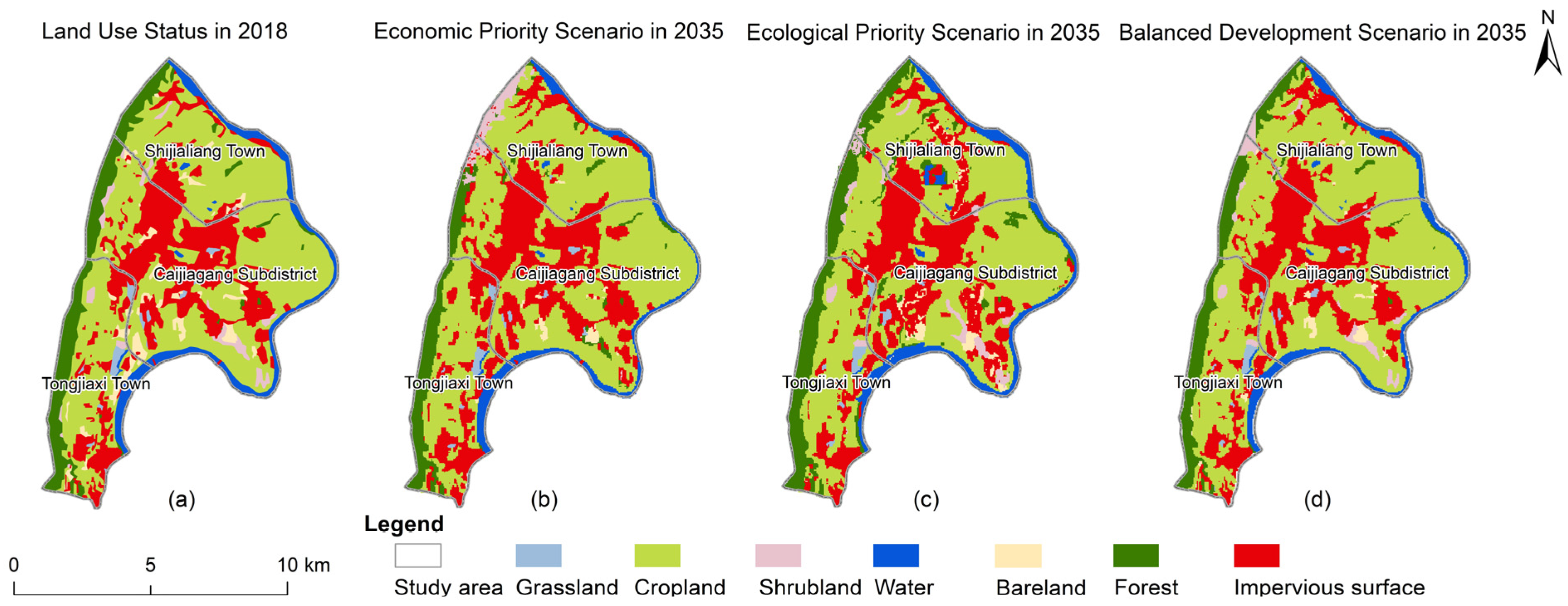
4.3. Spatial Layout Optimization Results
4.3.1. Economic Priority Scenario
4.3.2. Ecological Priority Scenario
4.3.3. Balanced Development Scenario
5. Discussion
6. Conclusions
Author Contributions
Funding
Data Availability Statement
Conflicts of Interest
References
- Bren d’Amour, C.; Reitsma, F.; Baiocchi, G.; Barthel, S.; Güneralp, B.; Erb, K.H.; Haberl, H.; Creutzig, F.; Seto, K.C. Future urban land expansion and implications for global croplands. Proc. Natl. Acad. Sci. USA 2017, 114, 8939–8944. [Google Scholar] [CrossRef] [PubMed]
- Kalnay, E.; Cai, M. Impact of urbanization and land-use change on climate. Nature 2003, 423, 528–531. [Google Scholar] [CrossRef] [PubMed]
- Ouyang, Z.; Sciusco, P.; Jiao, T.; Feron, S.; Lei, C.; Li, F.; John, R.; Fan, P.; Williams, C.A.; Chen, G.; et al. Albedo changes caused by future urbanization contribute to global warming. Nat. Commun. 2022, 13, 3800. [Google Scholar] [CrossRef] [PubMed]
- Sun, B.; Lu, Y.; Yang, Y.; Yu, M.; Yuan, J.; Yu, R.; Bullock, M.J.; Stenseth, N.C.; Li, X.; Cao, Z.; et al. Urbanization affects spatial variation and species similarity of bird diversity distribution. Sci. Adv. 2022, 8, eade3061. [Google Scholar] [CrossRef] [PubMed]
- Zhang, X.; Brandt, M.; Tong, X.; Ciais, P.; Yue, Y.; Xiao, X.; Zhang, W.; Wang, K.; Fensholt, R. A large but transient carbon sink from urbanization and rural depopulation in China. Nat. Sustain. 2022, 5, 321–328. [Google Scholar] [CrossRef]
- Zhang, L.; Yang, L.; Zohner, C.M.; Crowther, T.W.; Li, M.; Shen, F.; Guo, M.; Qin, J.; Yao, L.; Zhou, C. Direct and indirect impacts of urbanization on vegetation growth across the world’s cities. Sci. Adv. 2022, 8, eabo0095. [Google Scholar] [CrossRef]
- Zhao, S.; Liu, S.; Zhou, D. Prevalent vegetation growth enhancement in urban environment. Proc. Natl. Acad. Sci. USA 2016, 113, 6313–6318. [Google Scholar] [CrossRef]
- Lu, D. The content framework of geography research on the field of urbanization. Sci. Geogr. Sin. 2013, 33, 897–901. (In Chinese) [Google Scholar]
- Shiferaw, H.; Alamirew, T.; Kassawmar, T.; Kassawmar, T.; Zeleke, G. Evaluating ecosystems services values due to land use transformation in the Gojeb watershed, Southwest Ethiopia. Environ. Syst. Res. 2021, 10, 22. [Google Scholar] [CrossRef]
- Maimaiti, B.; Chen, S.; Kasimu, A.; Simayi, Z.; Aierken, N. Urban spatial expansion and its impacts on ecosystem service value of typical oasis cities around Tarim Basin, northwest China. Int. J. Appl. Earth Obs. 2021, 104, 102554. [Google Scholar] [CrossRef]
- Stańczuk-Gałwiaczek, M.; Sobolewska-Mikulska, K.; Ritzema, H.; van Loon-Steensma, J.M. Integration of water management and land consolidation in rural areas to adapt to climate change: Experiences from Poland and the Netherlands. Land Use Policy 2018, 77, 498–511. [Google Scholar] [CrossRef]
- Searchinger, T.D.; Wirsenius, S.; Beringer, T.; Dumas, P. Assessing the efficiency of changes in land use for mitigating climate change. Nature 2018, 564, 249–253. [Google Scholar] [CrossRef] [PubMed]
- Yang, J.; Guo, A.; Li, Y.; Zhang, Y.; Li, X. Simulation of landscape spatial layout evolution in rural-urban fringe areas: A case study of Ganjingzi District. GISci. Remote Sens. 2019, 56, 388–405. [Google Scholar] [CrossRef]
- Stewart, T.J.; Janssen, R. A multi-objective GIS-based land use planning algorithm. Comput. Environ. Urban Syst. 2014, 46, 25–34. [Google Scholar] [CrossRef]
- Han, Z.; Song, W. Identification and geographic distribution of accommodation and catering centers. ISPRS Int. J. Geo-Inform. 2020, 9, 546. [Google Scholar] [CrossRef]
- Hansen, R.; Olafsson, A.S.; Van Der Jagt, A.P.; Rall, E.; Pauleit, S. Planning multifunctional green infrastructure for compact cities: What is the state of practice? Ecol. Indic. 2019, 96, 99–110. [Google Scholar] [CrossRef]
- Hao, Q.; Deng, L.; Feng, Z. The “Double Evaluation” under the context of spatial planning: Wicked problems and restricted rationality. J. Nat. Resour. 2021, 36, 541–551. (In Chinese) [Google Scholar] [CrossRef]
- Liao, S.; Wu, Y.; Wong, S.W.; Shen, L. Provincial perspective analysis on the coordination between urbanization growth and resource environment carrying capacity (RECC) in China. Sci. Total Environ. 2020, 730, 138964. [Google Scholar] [CrossRef]
- Fan, Y.; Jin, X.; Gan, L.; Jessup, L.H.; Pijanowski, B.C.; Yang, X.; Xiang, X.; Zhou, Y. Spatial identification and dynamic analysis of land use functions reveals distinct zones of multiple functions in eastern China. Sci. Total Environ. 2018, 642, 33–44. [Google Scholar] [CrossRef]
- Jiang, X.; Zhai, S.; Liu, H.; Chen, J.; Zhu, Y.; Wang, Z. Multi-scenario simulation of production-living-ecological space and ecological effects based on shared socioeconomic pathways in Zhengzhou, China. Ecol. Indic. 2022, 137, 108750. [Google Scholar] [CrossRef]
- Yang, X.; Chen, X.; Che, L.; Qiao, F.; Pu, L. Optimizing the functional layout of land use integrated ecological security in Lanzhou Xining urban agglomeration. Acta Ecol. Sin. 2023, 43, 2583–2593. (In Chinese) [Google Scholar]
- Chen, Y.; Zhang, L.; He, L.; Men, M. Multi-scenario simulation of land use structure based on dual combined models. Acta Ecol. Sin. 2016, 36, 5391–5400. (In Chinese) [Google Scholar]
- Kaim, A.; Cord, A.F.; Volk, M. A review of multi-criteria optimization techniques for agricultural land use allocation. Environ. Modell. Softw. 2018, 105, 79–93. [Google Scholar] [CrossRef]
- Cao, S.; Jin, X.; Yang, X.; Sun, R.; Liu, J.; Han, B.; Xu, W.; Zhou, Y. Coupled MOP and GeoSOS-FLUS models research on optimization of land use structure and layouts in Jintan district. J. Nat. Resour. 2019, 34, 1171–1185. (In Chinese) [Google Scholar] [CrossRef]
- Newland, C.P.; Maier, H.R.; Zecchin, A.C.; Newman, J.P.; van Delden, H. Multi-objective optimization framework for calibration of Cellular Automata land-use models. Environ. Modell. Softw. 2018, 100, 175–200. [Google Scholar] [CrossRef]
- Verburg, P.H.; Soepboer, W.; Veldkamp, A.; Limpiada, R.; Espaldon, V.; Mastura, S.S. Modeling the spatial dynamics of regional land use: The CLUE-S model. Environ. Manag. 2002, 30, 391–405. [Google Scholar] [CrossRef] [PubMed]
- Liao, G.; He, P.; Gao, X.; Lin, Z.; Huang, C.; Zhou, W.; Deng, O.; Xu, C.; Deng, L. Land use optimization of rural production–living–ecological space at different scales based on the BP–ANN and CLUE–S models. Ecol. Indic. 2022, 137, 108710. [Google Scholar] [CrossRef]
- Wang, Q.; Liu, R.; Men, C.; Guo, L. Application of genetic algorithm to land use optimization for non-point source pollution control based on CLUE-S and SWAT. J. Hydrol. 2018, 560, 86–96. [Google Scholar] [CrossRef]
- Gounaridis, D.; Chorianopoulos, I.; Symeonakis, E.; Koukoulas, S. A Random Forest-Cellular Automata modelling approach to explore future land use/cover change in Attica (Greece), under different socio-economic realities and scales. Sci. Total Environ. 2019, 646, 320–335. [Google Scholar] [CrossRef]
- Yang, J.; Gong, J.; Tang, W.; Liu, C. Patch-based cellular automata model of urban growth simulation: Integrating feedback between quantitative composition and spatial configuration. Comput. Environ. Urban Syst. 2020, 79, 101402. [Google Scholar] [CrossRef]
- Chen, Z.; Huang, M.; Zhu, D.; Altan, O. Integrating remote sensing and a markov-FLUS model to simulate future land use changes in Hokkaido, Japan. Remote Sens. 2021, 13, 2621. [Google Scholar] [CrossRef]
- Liu, X.; Liang, X.; Li, X.; Xu, X.; Ou, J.; Chen, Y.; Li, S.; Wang, S.; Pei, F. A future land use simulation model (FLUS) for simulating multiple land use scenarios by coupling human and natural effects. Landsc. Urban Plan. 2017, 168, 94–116. [Google Scholar] [CrossRef]
- Zhang, H.; Shi, M.; Cao, Y.; Jiang, Y. Optimization of land use landscape pattern and multi-scenario simulation in Aksu region of Xinjiang based on MOP-PLUS model. Southwest China J. Agric. Sci. 2022, 35, 2256–2264. (In Chinese) [Google Scholar]
- Li, Y.; Yao, S.; Jiang, H.; Wang, H.; Ran, Q.; Gao, X.; Ding, X.; Ge, D. Spatial-Temporal Evolution and Prediction of Carbon Storage: An Integrated Framework Based on the MOP–PLUS–InVEST Model and an Applied Case Study in Hangzhou, East China. Land 2022, 11, 2213. [Google Scholar] [CrossRef]
- Anand, J.; Gosain, A.K.; Khosa, R. Prediction of land use changes based on Land Change Modeler and attribution of changes in the water balance of Ganga basin to land use change using the SWAT model. Sci. Total Environ. 2018, 644, 503–519. [Google Scholar] [CrossRef]
- Zhou, Y.; Chen, M.; Tang, Z.; Mei, Z. Urbanization, land use change, and carbon emissions: Quantitative assessments for city-level carbon emissions in Beijing-Tianjin-Hebei region. Sustain. Cities Soc. 2021, 66, 102701. [Google Scholar] [CrossRef]
- Dadashpoor, H.; Azizi, P.; Moghadasi, M. Land use change, urbanization, and change in landscape pattern in a metropolitan area. Sci. Total Environ. 2019, 655, 707–719. [Google Scholar] [CrossRef]
- Lou, Y.; Yang, D.; Zhang, P.; Zhang, Y.; Song, M.; Huang, Y.; Jing, W. Multi-scenario simulation of land use changes with ecosystem service value in the Yellow River Basin. Land 2022, 11, 992. [Google Scholar] [CrossRef]
- Salazar, E.; Henríquez, C.; Sliuzas, R.; Qüense, J. Evaluating spatial scenarios for sustainable development in Quito, Ecuador. ISPRS Int. J. Geo-Inform. 2020, 9, 141. [Google Scholar] [CrossRef]
- Chen, W.; Chi, G.; Li, J. The spatial association of ecosystem services with land use and land cover change at the county level in China, 1995–2015. Sci. Total Environ. 2019, 669, 459–470. [Google Scholar] [CrossRef]
- Zheng, L.; Wu, M.; Zhou, M.; Zhao, L.; Wang, J.; Luan, S. Research on land resource development under county land use change: A case study of Fushan District, Yantai city. Ecol. Sci. 2023, 42, 114–123. (In Chinese) [Google Scholar]
- Sang, L.; Zhang, C.; Yang, J.; Zhu, D.; Yun, W. Simulation of land use spatial pattern of towns and villages based on CA–Markov model. Math. Comp. Modell. 2011, 54, 938–943. [Google Scholar] [CrossRef]
- Zheng, H.; Wang, L.; Peng, W.; Zhang, C.; Li, C.; Robinson, B.E.; Wu, X.; Kong, L.; Li, R.; Xiao, Y.; et al. Realizing the values of natural capital for inclusive, sustainable development: Informing China’s new ecological development strategy. Proc. Natl. Acad. Sci. USA 2019, 116, 8623–8628. [Google Scholar] [CrossRef] [PubMed]
- Liang, X.; Guan, Q.; Clarke, K.C.; Liu, S.; Wang, B.; Yao, Y. Understanding the drivers of sustainable land expansion using a patch-generating land use simulation (PLUS) model: A case study in Wuhan, China. Comput. Environ. Urban Syst. 2021, 85, 101569. [Google Scholar] [CrossRef]
- GB/T21010-2017; Current Land Use Classification. Natural Resources and Territory Spatial Planning. General Administration of Quality Supervision, Inspection and Quarantine of the People’s Republic of China, Standardization Administration of the People’s Republic of China: Beijing, China, 2017.
- Zhou, M. An interval fuzzy chance-constrained programming model for sustainable urban land-use planning and land use policy analysis. Land Use Policy 2015, 42, 479–491. [Google Scholar] [CrossRef]
- Rahman, M.M.; Szabó, G. Multi-objective urban land use optimization using spatial data: A systematic review. Sustain. Cities Soc. 2021, 74, 103214. [Google Scholar] [CrossRef]
- Sannigrahi, S.; Chakraborti, S.; Joshi, P.K.; Keesstra, S.; Sen, S.; Paul, S.K.; Kreuter, U.; Sutton, P.C.; Jha, S.; Dang, K.B. Ecosystem service value assessment of a natural reserve region for strengthening protection and conservation. J. Environ. Manag. 2019, 244, 208–227. [Google Scholar] [CrossRef]
- Xie, G.; Lu, C.; Leng, Y.; Zheng, D.; Li, S. Ecological assets valuation of the Tibetan Plateau. J. Nat. Resour. 2003, 2, 189–196. (In Chinese) [Google Scholar]
- Pan, Y.; Shi, P.; Zhu, W.; Gu, X.; Fan, Y.; Li, J. Quantitative measurement of ecological assets of terrestrial ecosystems in China by remote sensing. Sci. China Ser. D-Earth Sci. 2004, 4, 375–384. (In Chinese) [Google Scholar]
- Zhao, J.; Shao, Z.; Xia, C.; Fang, K.; Chen, R.; Zhou, J. Ecosystem services assessment based on land use simulation: A case study in the Heihe River Basin, China. Ecol. Indic. 2022, 143, 109402. [Google Scholar] [CrossRef]
- Fu, Q.; Hou, Y.; Wang, B.; Bi, X.; Li, B.; Zhang, X. Scenario analysis of ecosystem service changes and interactions in a mountain-oasis-desert system: A case study in Altay Prefecture, China. Sci. Rep. 2018, 8, 12939. [Google Scholar] [CrossRef] [PubMed]
- Meentemeyer, R.K.; Tang, W.; Dorning, M.A.; Vogler, J.B.; Cunniffe, N.J.; Shoemaker, D.A. FUTURES: Multilevel simulations of emerging urban-rural landscape structure using a stochastic patch-growing algorithm. Ann. Am. Assoc. Geogr. 2013, 103, 785–807. [Google Scholar] [CrossRef]


| Category | Data/Material | Resolution | Source | Data Usage | |
|---|---|---|---|---|---|
| Socio-economic data | Economic statistical data | Chongqing Statistics Bureau | Calculation of economic efficiency factor | ||
| Density of population | 1 km | Resource and Environment Science and Data Center | Socio-economic drivers | ||
| GDP | 1 km | ||||
| Chongqing Land Use Master Planning (2006–2020) | Chongqing Planning and Natural Resources Bureau | Reference material | |||
| Territorial Spatial Planning of Chongqing Municipality (2021–2035) | |||||
| Current Land Use Classification (GB/T21010-2017) | |||||
| Land use/cover data | Landsat 8 | LC08_L2SP_128039_20150708 | 30 m | GEE | PLUS model input |
| LC08_L2SP_128039_20160710 | |||||
| LC08_L2SP_128039_20170915 | |||||
| LC08_L2SP_128039_20180902 | |||||
| Fundamental geographic data | DEM | 30 m | Geospatial Data Cloud | Natural factor drivers | |
| Soil types | 1 km | Resource and Environment Science and Data Center | |||
| Transportation networks | Open Street Map | Traffic accessibility drivers | |||
| Railway stations | Chongqing Geographic Information Center | ||||
| Administrative division | Relevant analysis | ||||
| Other data | NPP | 1 km | Resource and Environment Science and Data Center | Modification of the ecological efficiency factor | |
| NDVI | 1 km | ||||
| Economic Sectors | The Secondary and Tertiary Sectors | Forestry | Farming | Husbandry | Tea Gardens and Orchards | Fishery | |
|---|---|---|---|---|---|---|---|
| Year | |||||||
| 2015 | 2,417,527.74 | 573.76 | 12,560.73 | 8846.65 | 774.47 | 4695.26 | |
| 2016 | 2,680,109.26 | 676.52 | 14,493.15 | 7465.13 | 906.15 | 5185.99 | |
| 2017 | 2,868,781.64 | 1010.50 | 14,309.11 | 7324.87 | 1204.15 | 6985.34 | |
| 2018 | 2,866,303.04 | 1224.59 | 15,551.38 | 7481.78 | 1325.44 | 7324.61 | |
| Constraint | Formula | Description |
|---|---|---|
| Total area | , S = 8770.69 (ha) | The total area of the study area should remain unchanged. |
| Planning population in 2035 | Based on the urban and farmland population density and total population in Chongqing from 2015 to 2018, the values in 2035 are projected using the GF model as follows: = 75.36, = 4.36 (persons per hectare), = 487,787. By 2035, the total population is not to be larger than 487,787. | |
| Ecological environment | With ecological environment protection as a constraint, it is ensured that the areas of forest, cropland, grassland, and shrubland are within an appropriate range . The value 5718.28 represents the total area of , , , and in 2018. | |
| Flexible planning | The elasticity coefficient is set within the interval [0.75, 1.25]. It was determined based on the proportions of cropland, forest, grassland, and shrubland as specified in the “Land Use Planning”, taking into account historical trends and the length of the forecasting period. | |
| Policies | According to “Spatial Planning”, the urban and rural construction land is projected to increase by 17.64% in 2035, with a stable increase in the area of shrubland. Therefore, the area of construction land should be between 2136.72 and 2513.63 (ha), with the shrubland area not being less than 173.26 (ha). | |
| Land development utilization rate | ≤ 309.85 | The land development utilization rate () in 2035 should not be lower than that in 2018; the bare land area should be greater than 309.85 (ha). is calculated using the following formula: = ((S − )/S) × 100%. |
| Decision variable non-negative | The area of each land use type should not be less than 0. |
| Category | Driver |
|---|---|
| Natural factor | Elevation |
| Slope | |
| Soil Types | |
| Social factor | GDP |
| Population density | |
| Traffic accessibility factor | Distance to Train Station |
| Distance to Highway | |
| Distance to Railway | |
| Distance to Main Road | |
| Distance to Primary Road | |
| Distance to Secondary Road | |
| Distance to Tertiary Road |
| Land Type | Total Pixel | Correctly Simulated Pixels | Accuracy (%) |
|---|---|---|---|
| Impervious surface | 20,648 | 15,863 | 76.83 |
| Forest | 12,694 | 10,161 | 80.05 |
| Cropland | 44,360 | 35,204 | 79.36 |
| Grassland | 999 | 887 | 88.79 |
| Shrubland | 1627 | 1346 | 82.73 |
| Water | 14,457 | 13,507 | 93.43 |
| Bare land | 2987 | 2092 | 70.04 |
| Variable Symbol | Variable Name | Status in 2018 | Different Development Scenarios in 2035 | |||||
|---|---|---|---|---|---|---|---|---|
| Econ. Prior. Scenario | Ecol. Prior. Scenario | BD Scenario | ||||||
| Area (ha) | Area (ha) | Change from 2018 (ha) | Area (ha) | Change from 2018 (ha) | Area (ha) | Change from 2018 (ha) | ||
| Impervious surface | 2136.72 | 2513.63 | 376.91 | 2202.81 | 66.09 | 2401.83 | 265.11 | |
| Forest | 856.36 | 685.71 | 170.65 | 933.43 | 77.07 | 793.44 | 62.92 | |
| Cropland | 4601.00 | 4574.88 | 26.12 | 4536.90 | 64.10 | 4561.83 | 39.17 | |
| Grassland | 87.66 | 88.56 | 0.90 | 84.33 | 3.33 | 74.79 | 12.87 | |
| Shrubland | 173.26 | 224.36 | 51.10 | 216.58 | 43.32 | 237.61 | 64.35 | |
| Water | 605.84 | 598.23 | 7.61 | 624.24 | 18.40 | 608.22 | 2.38 | |
| Bare land | 309.85 | 85.32 | 224.53 | 171.36 | 138.49 | 92.97 | 216.88 | |
| Economic benefit (104 CNY) | 3.47 × 10⁶ | 4.06 × 10⁶ | 5.90 × 10⁵ | 3.50 × 10⁶ | 1.15 × 10⁵ | 3.89 × 10⁶ | 4.2 × 10⁵ | |
| Ecological benefit (104 CNY) | 7.23 × 10³ | 6.91 × 10³ | −321.58 | 7.46 × 10³ | 233.17 | 7.16 × 10³ | −71.56 | |
| Administrative Division | Impervious Surface Area in 2018 (ha) | Different Development Scenarios in 2035 | |||||
|---|---|---|---|---|---|---|---|
| Econ. Prior. Scenario | Ecol. Prior. Scenario | BD Scenario | |||||
| Area (ha) | Change from 2018 (ha) | Area (ha) | Change from 2018 (ha) | Area (ha) | Change from 2018 (ha) | ||
| Shijialiang Town | 217.53 | 264.96 | 47.43 | 289.98 | 72.45 | 277.92 | 60.39 |
| Caijiagang Subdistrict | 1408.14 | 1624.68 | 216.54 | 1428.75 | 20.61 | 1522.53 | 114.39 |
| Tongjiaxi Town | 511.05 | 623.99 | 112.94 | 484.08 | 26.97 | 601.38 | 90.33 |
Disclaimer/Publisher’s Note: The statements, opinions and data contained in all publications are solely those of the individual author(s) and contributor(s) and not of MDPI and/or the editor(s). MDPI and/or the editor(s) disclaim responsibility for any injury to people or property resulting from any ideas, methods, instructions or products referred to in the content. |
© 2023 by the authors. Licensee MDPI, Basel, Switzerland. This article is an open access article distributed under the terms and conditions of the Creative Commons Attribution (CC BY) license (https://creativecommons.org/licenses/by/4.0/).
Share and Cite
Zhong, Y.; Zhang, X.; Yang, Y.; Xue, M. Optimization and Simulation of Mountain City Land Use Based on MOP-PLUS Model: A Case Study of Caijia Cluster, Chongqing. ISPRS Int. J. Geo-Inf. 2023, 12, 451. https://doi.org/10.3390/ijgi12110451
Zhong Y, Zhang X, Yang Y, Xue M. Optimization and Simulation of Mountain City Land Use Based on MOP-PLUS Model: A Case Study of Caijia Cluster, Chongqing. ISPRS International Journal of Geo-Information. 2023; 12(11):451. https://doi.org/10.3390/ijgi12110451
Chicago/Turabian StyleZhong, Yuqing, Xiaoxiang Zhang, Yanfei Yang, and Minghui Xue. 2023. "Optimization and Simulation of Mountain City Land Use Based on MOP-PLUS Model: A Case Study of Caijia Cluster, Chongqing" ISPRS International Journal of Geo-Information 12, no. 11: 451. https://doi.org/10.3390/ijgi12110451
APA StyleZhong, Y., Zhang, X., Yang, Y., & Xue, M. (2023). Optimization and Simulation of Mountain City Land Use Based on MOP-PLUS Model: A Case Study of Caijia Cluster, Chongqing. ISPRS International Journal of Geo-Information, 12(11), 451. https://doi.org/10.3390/ijgi12110451