
Deducing Flood Development Process Using Social Media: An Event-Based and Multi-Level Modeling Approach


Abstract
:1. Introduction
2. Literature Review
3. Model
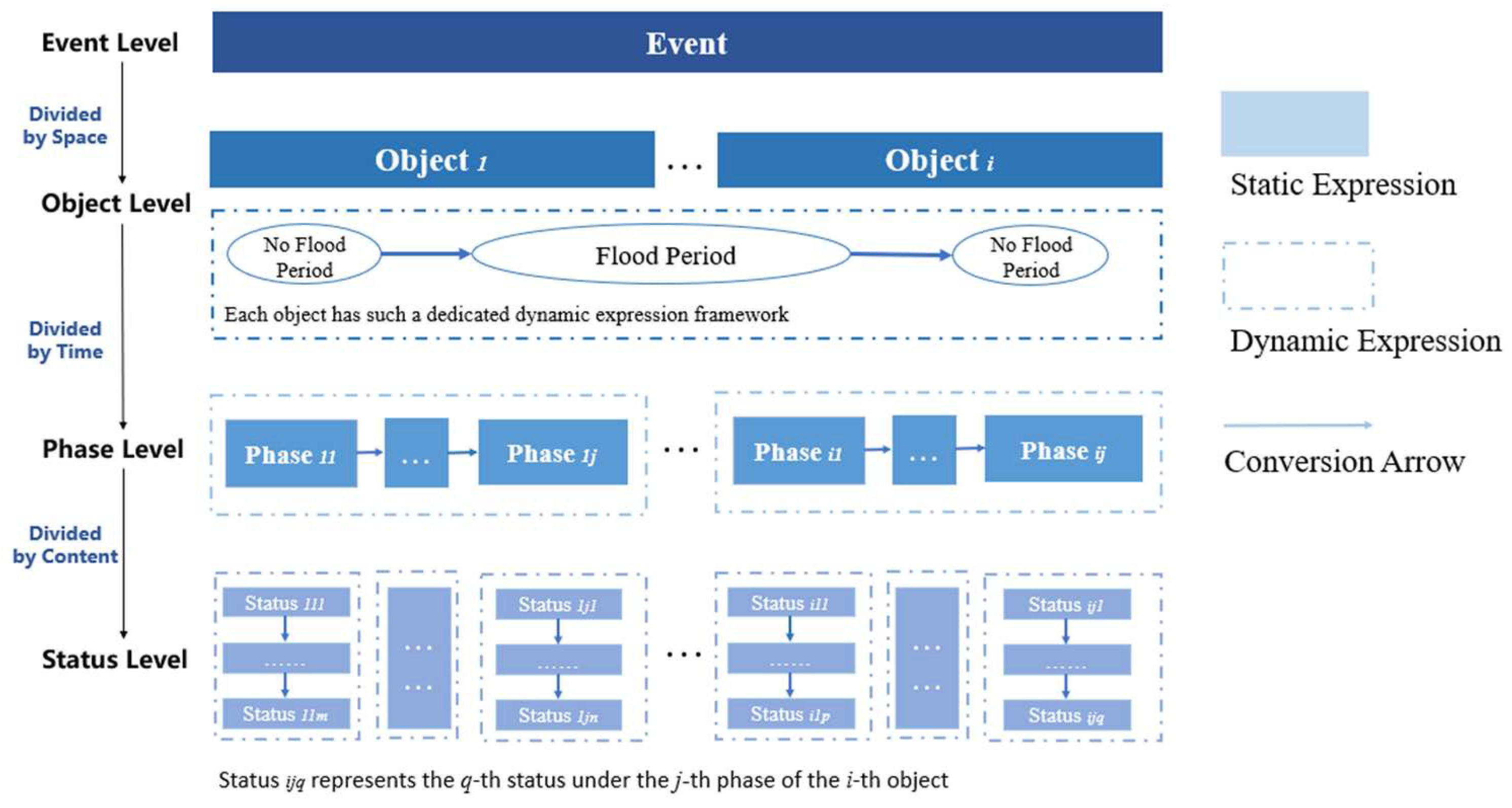
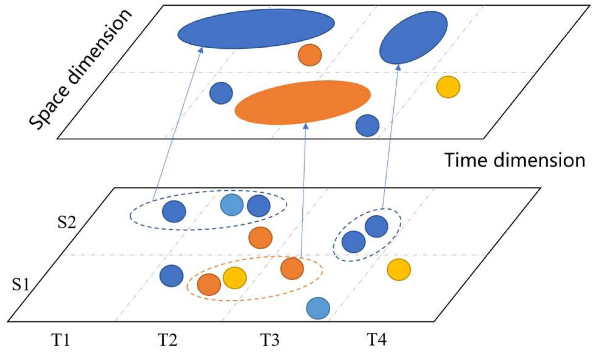
3.1. Description of EMMFPO
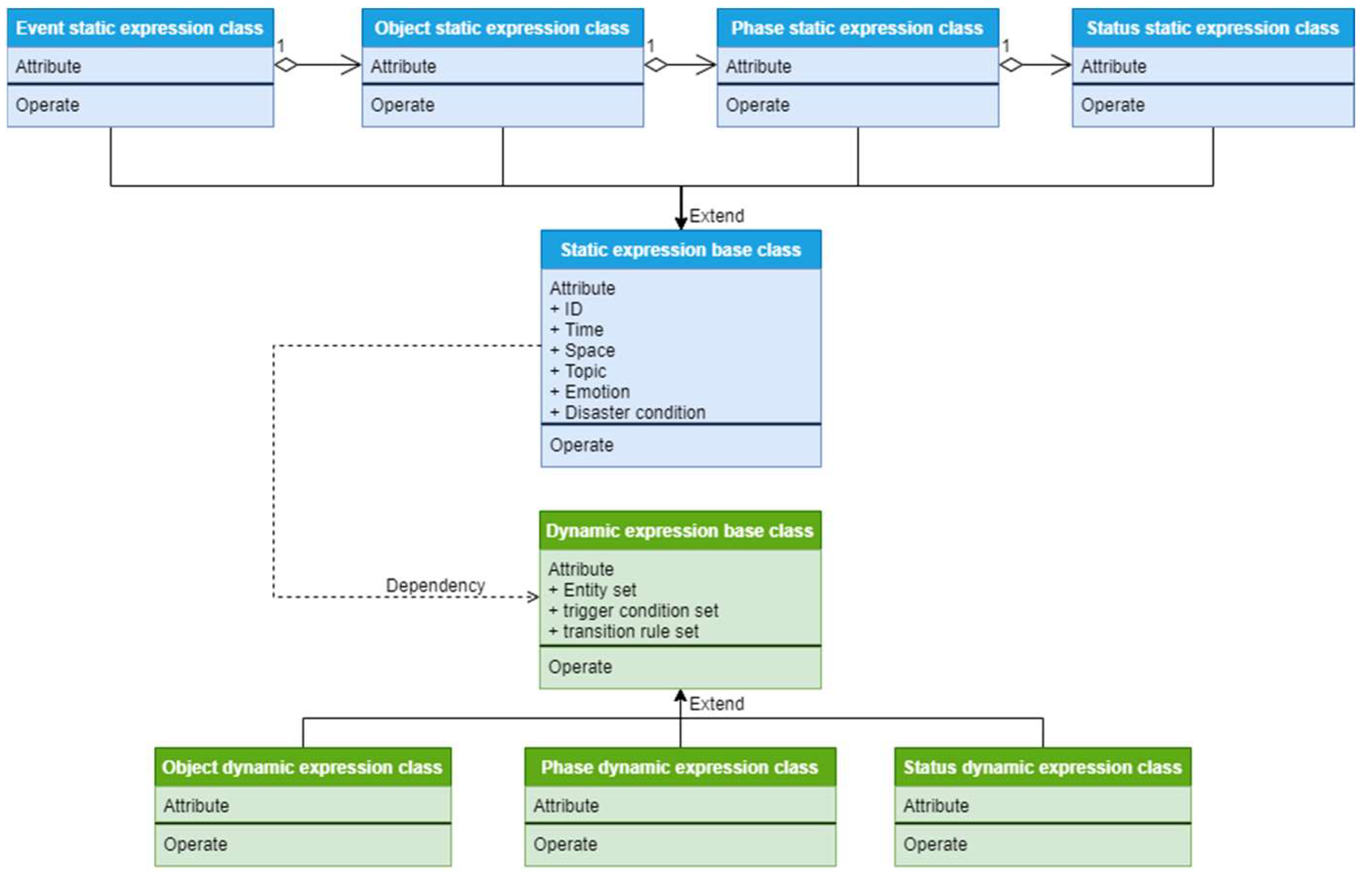
3.2. The Static Element Information Expression
3.2.1. The Structure of the Static Expression Base Class
- (I)
- ID
- (II)
- Time Element
- (III)
- Space Element
- (IV)
- Topic Element
- (V)
- Emotion Element
- (VI)
- Disaster Element
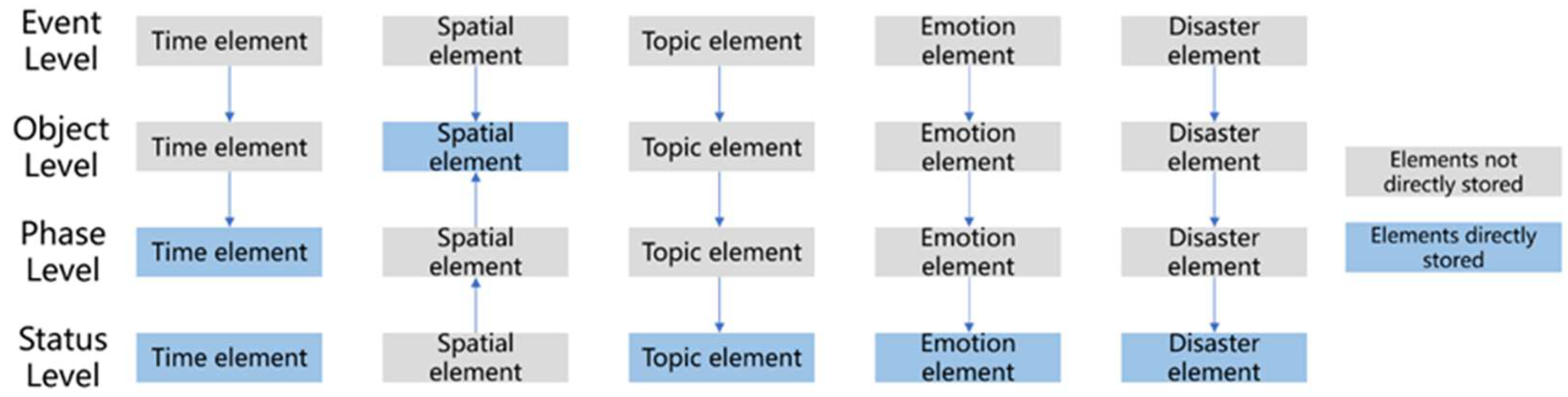
3.2.2. The Structure of the Static Expression Class in Levels
- (1)
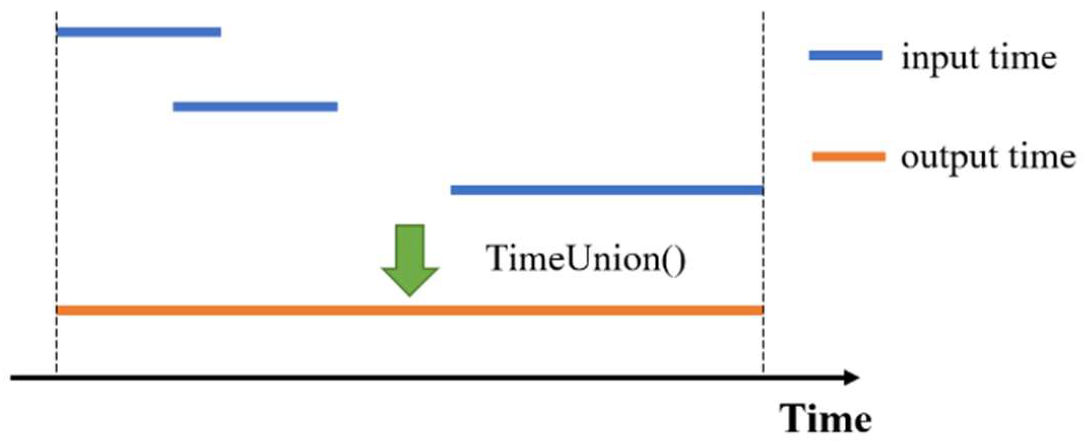
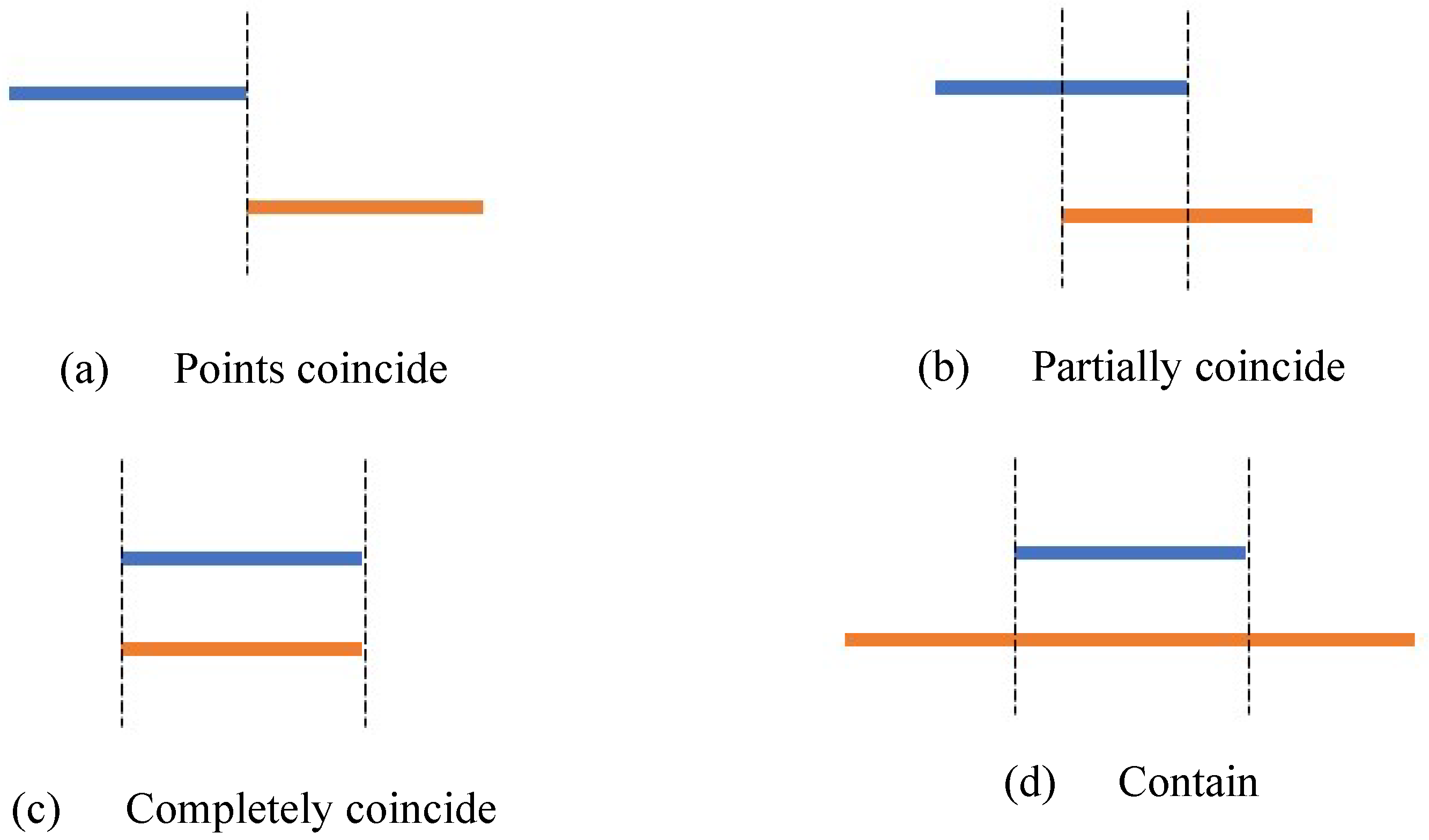
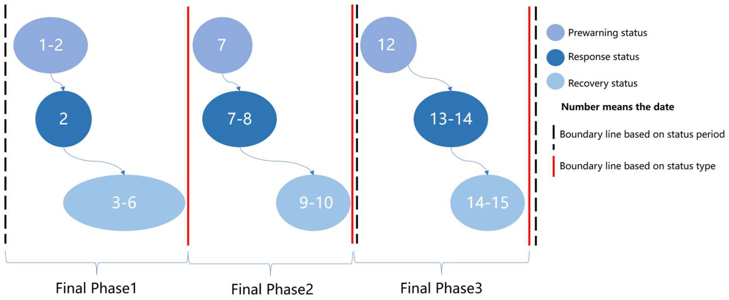
- The time element is determined by the union operation including the time element of the lower level ; see Equation (9).The union operation of time elements is defined as finding the shortest continuous time that can cover all the time elements involved in the lower level. The shortest continuous time is the result of the union operation. As shown in Figure 3, each line represents the time period.
- (2)
- The space element is obtained by searching the associated object entities. The space elements of the phase and status entities are consistent with the associated object entities, and the space element of the event entities is the union of the contained object entities.
- (3)
- The topic element is obtained by recalculating and sorting the popularity of topics at lower levels. The calculation method is shown in Equation (10).is the popularity of topic j in the entity at this level and NL() is the popularity of topic j corresponding to the entity contained in the next level. If the topic does not exist for a certain entity, the heat is recorded as 0.
- (4)
- The emotion elements are weighted and averaged by the emotion elements corresponding to all entities in the lower level; see Equation (11).represents the mean value of the i-th entity contained in the next level and is the corresponding weight that is determined by the number of FPO data involved in each entity.
- (5)
- The disaster element is obtained by consolidating the next level of disaster factors; see Equation (12).
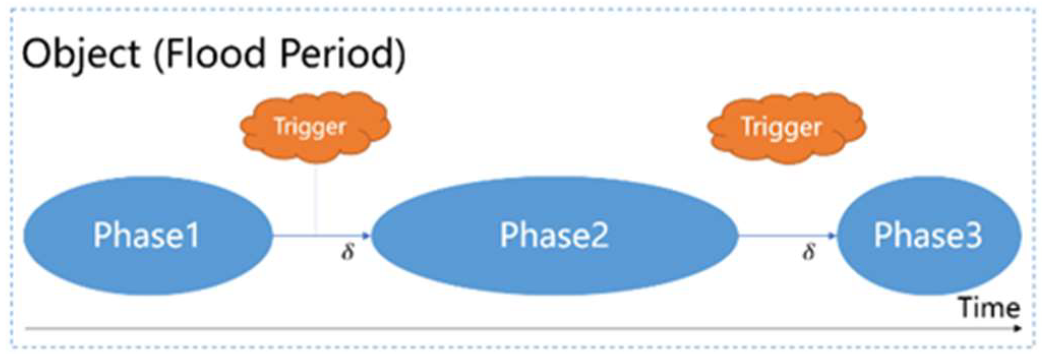
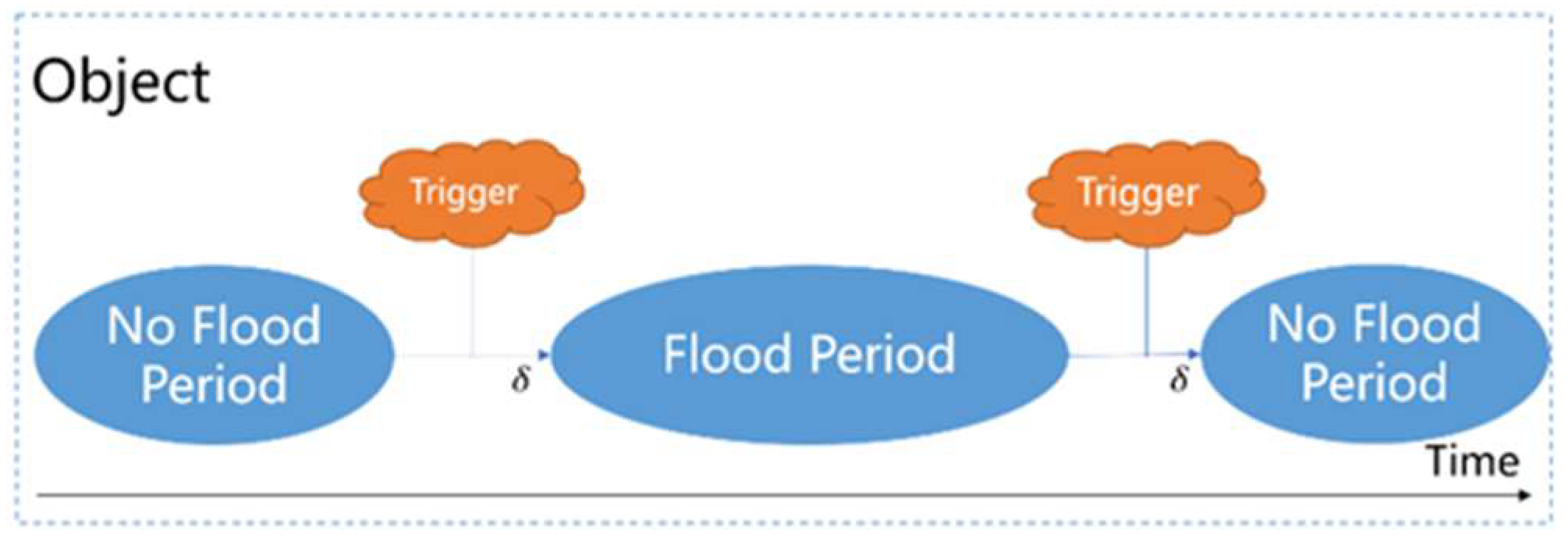
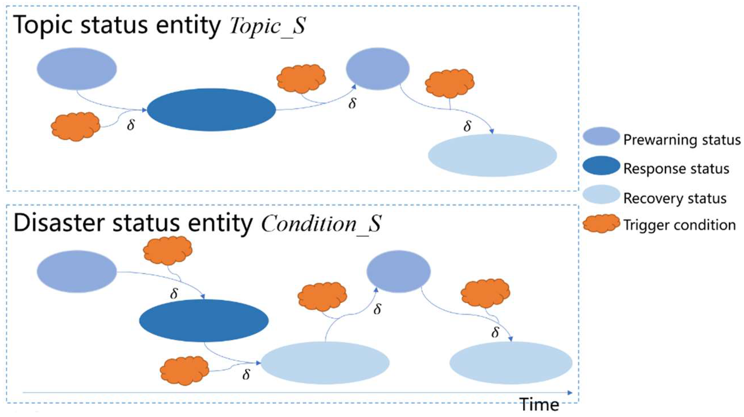
3.3. The Dynamic Development Process Expression
3.3.1. The Structure of the Dynamic Expression Base Class
3.3.2. The Structure of the Dynamic Expression Base Class
4. Method
4.1. FPO Entity Construction Method Based on Static Expression
- (1)
- For the structural information of prewarning and response, the release time and the area involved remain unchanged; the rank records the quantity in order of magnitude, and the form is the structure, e.g., [{‘rank’:’quantity’}]. Webid changes from an integer type to a collection, and the collection elements are all aggregated Webids.
- (2)
- For the structural information of disaster loss, the release time and the Webids are the same as in the above rule. However, it also includes the rules of SP, BL, EL, and FL, which are detailed in Table 1. The rule is mainly intended to select the maximum value of the extraction result.
4.2. Flood Development Deduction Method Based on Dynamic Expression
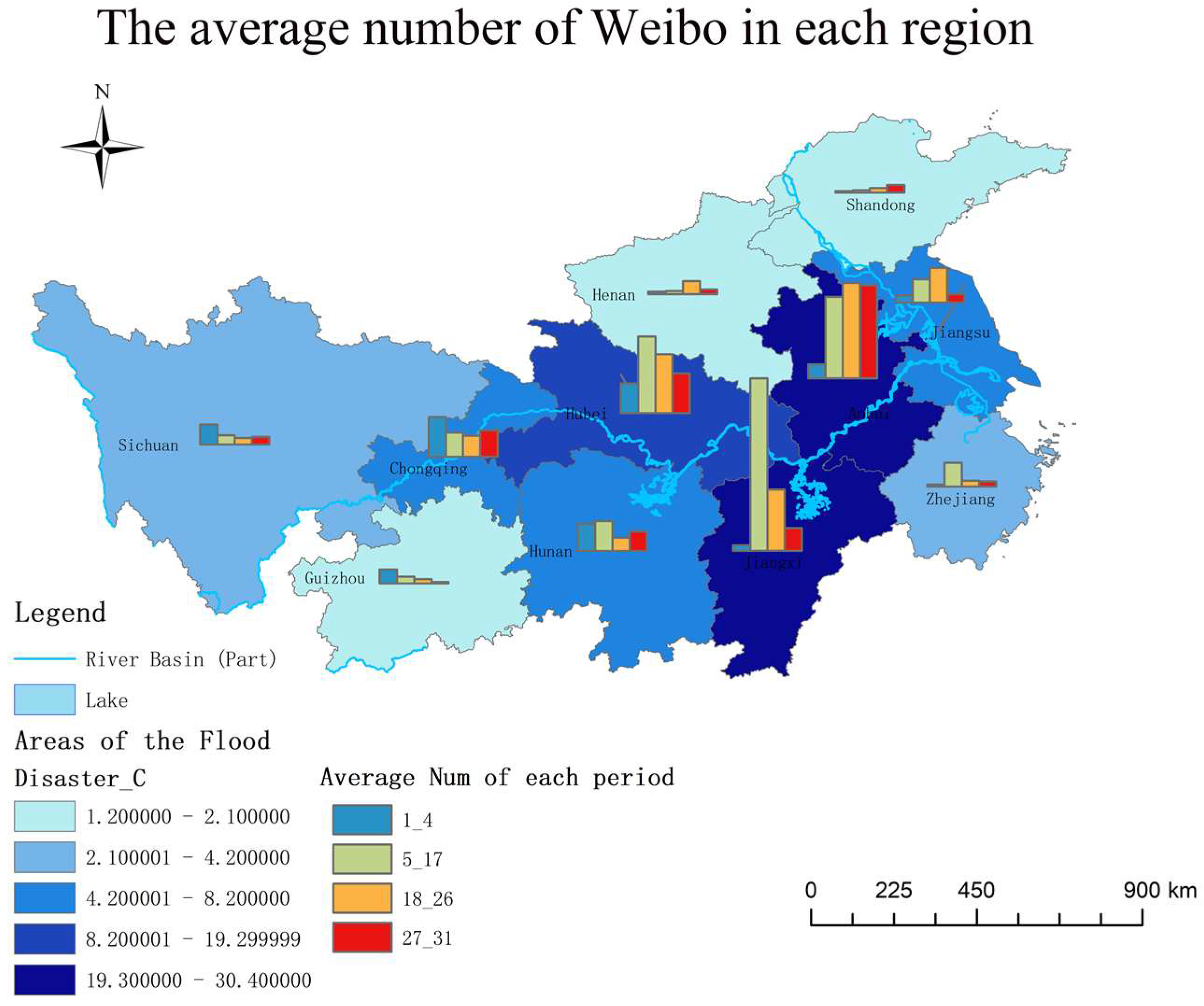
5. Case Study
5.1. Brief Introduction
5.2. Experimental Procedure
5.3. Results
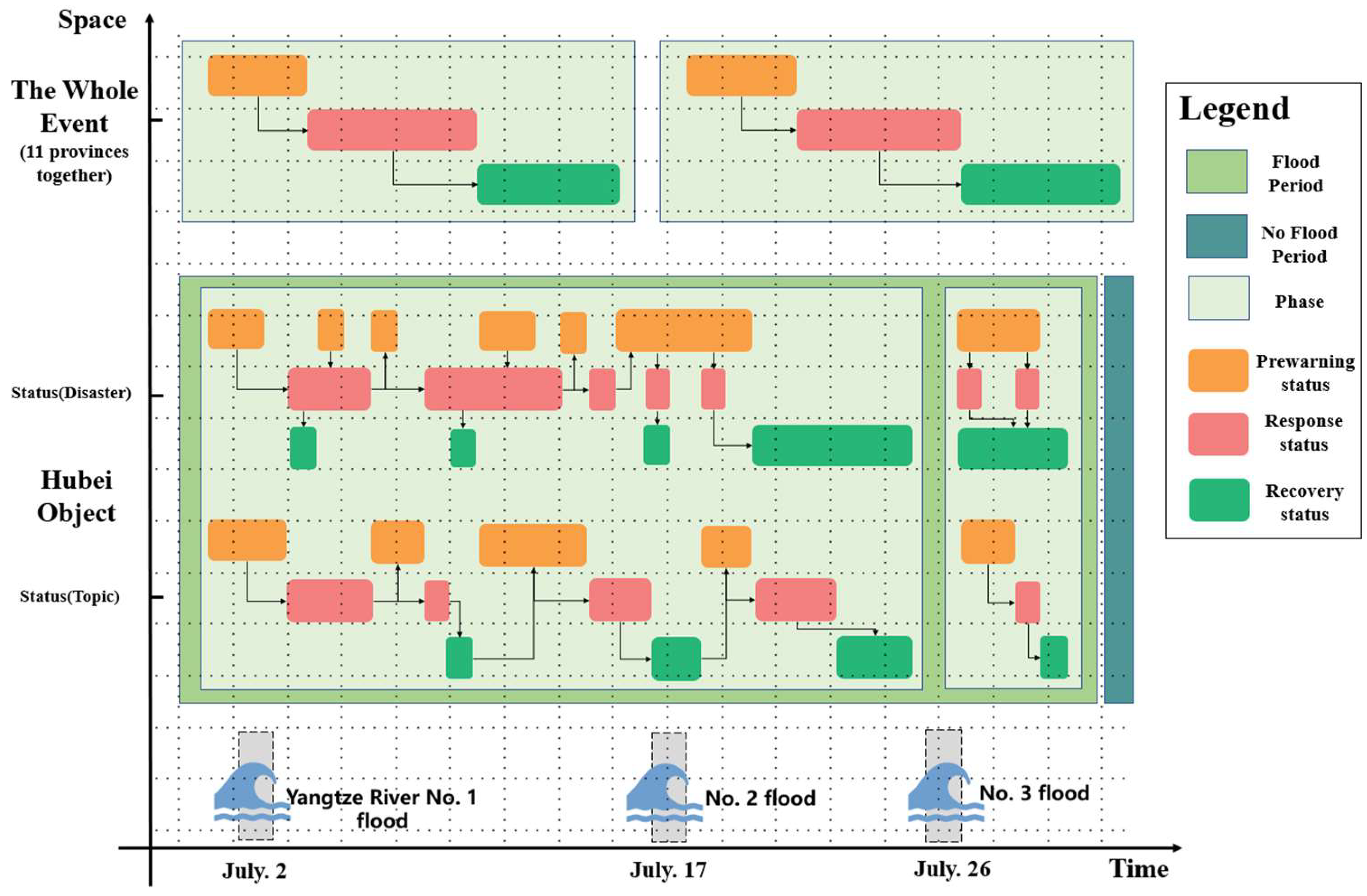
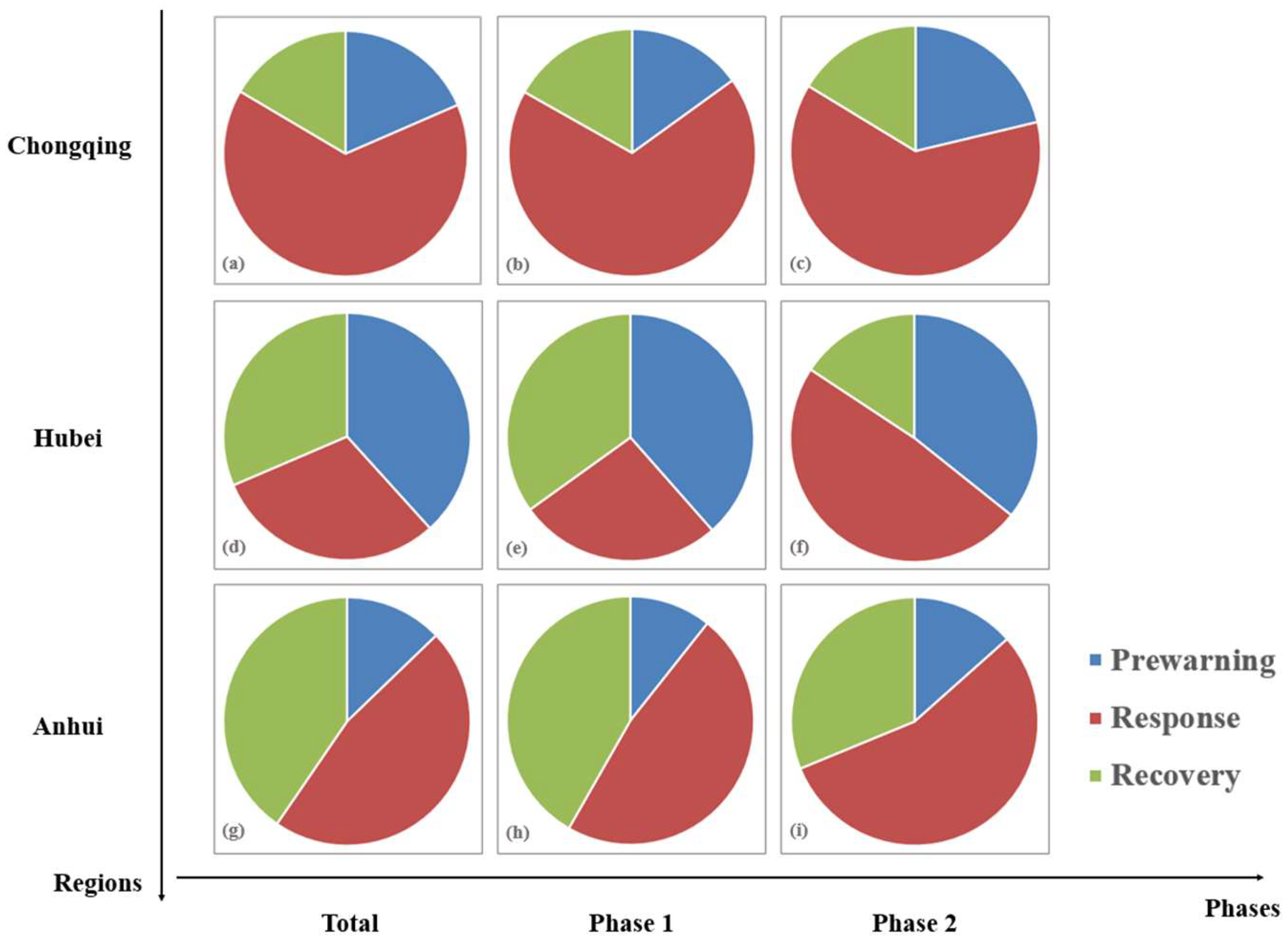
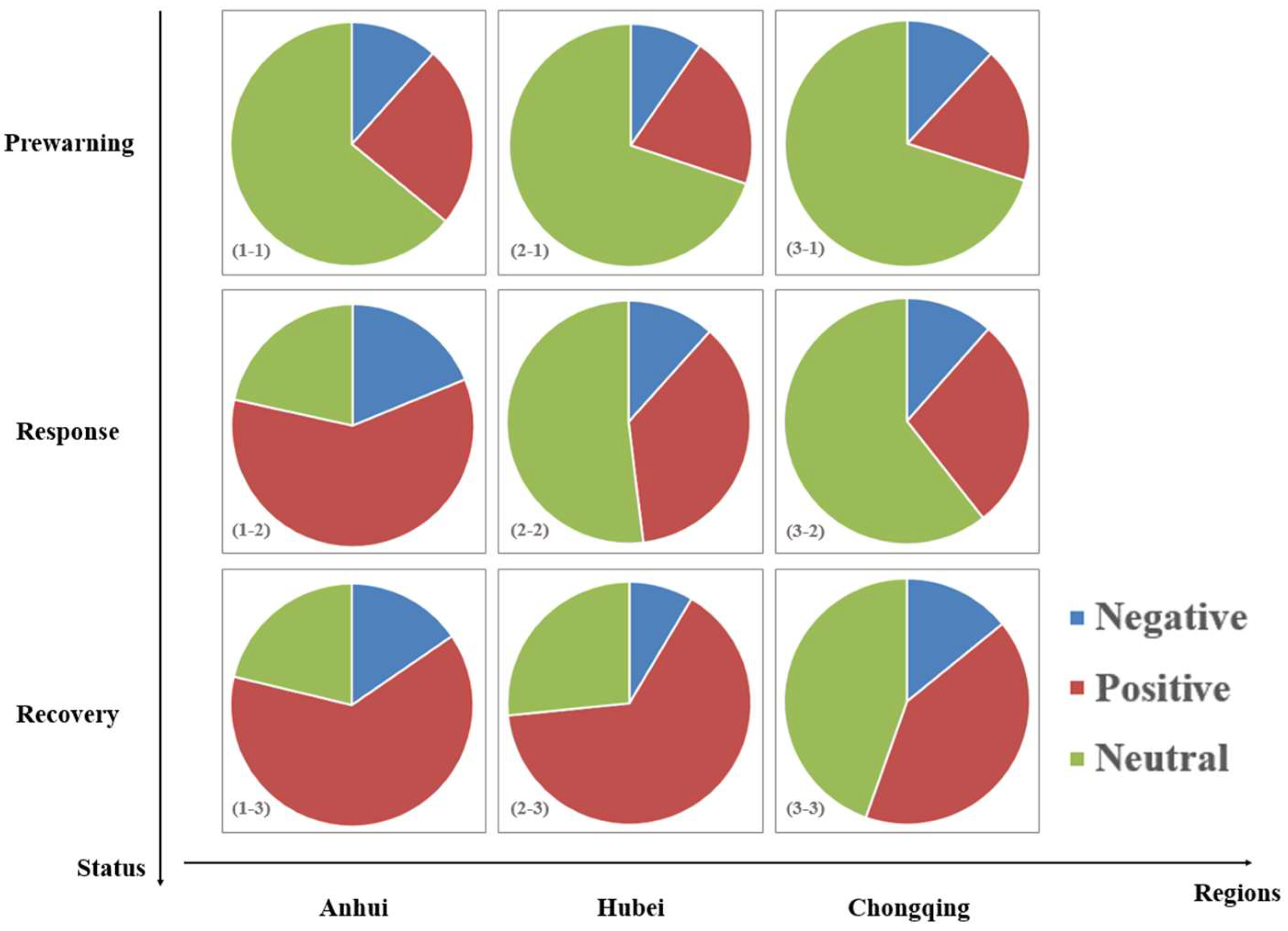
5.3.1. Flood Development Process
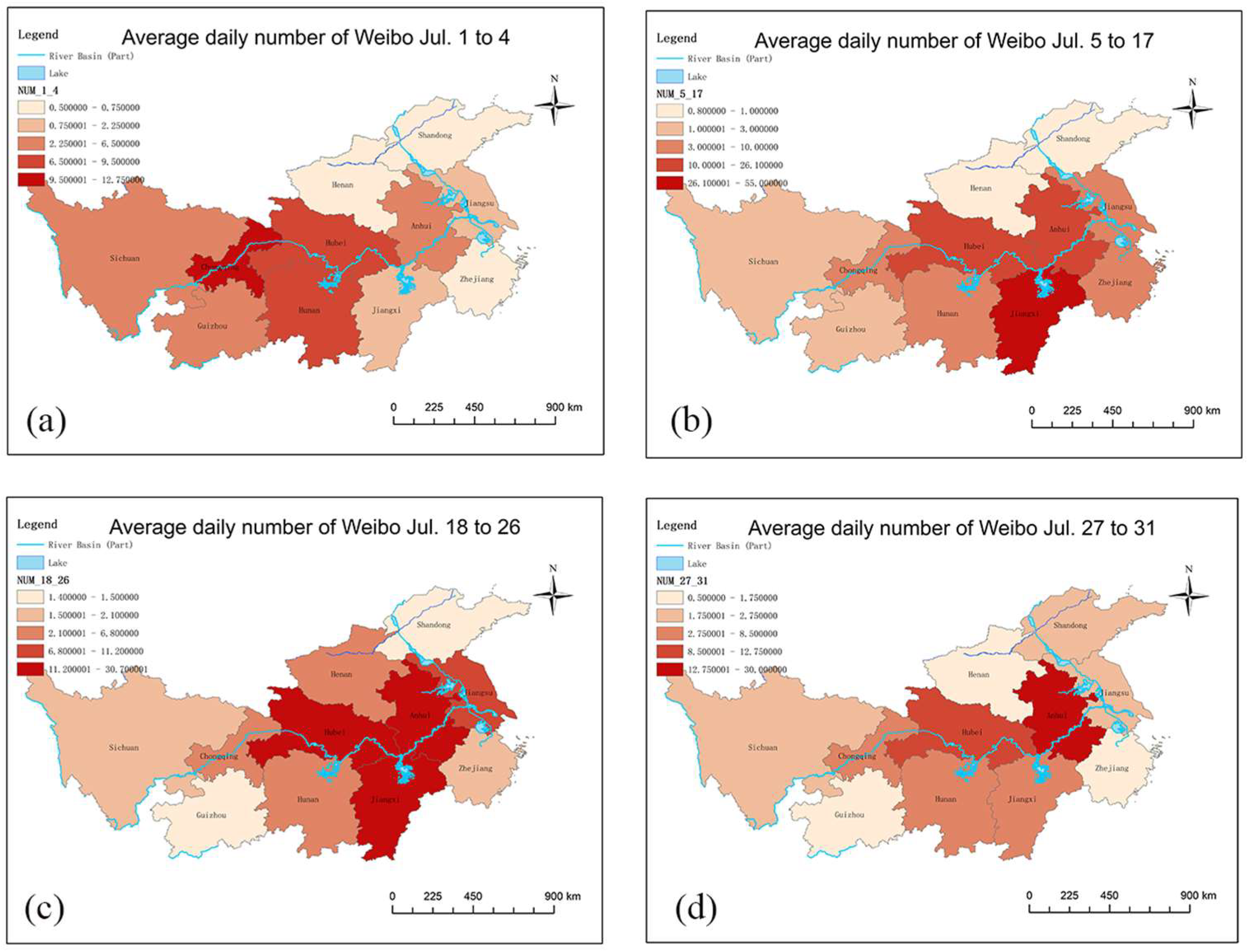
5.3.2. Spatiotemporal Analysis
6. Discussion and Conclusions
6.1. Discussion
6.2. Conclusions
Author Contributions
Funding
Institutional Review Board Statement
Informed Consent Statement
Data Availability Statement
Acknowledgments
Conflicts of Interest
Appendix A

| Element | Information |
|---|---|
| Time | ((1 July 2021), (30 July 2021)) |
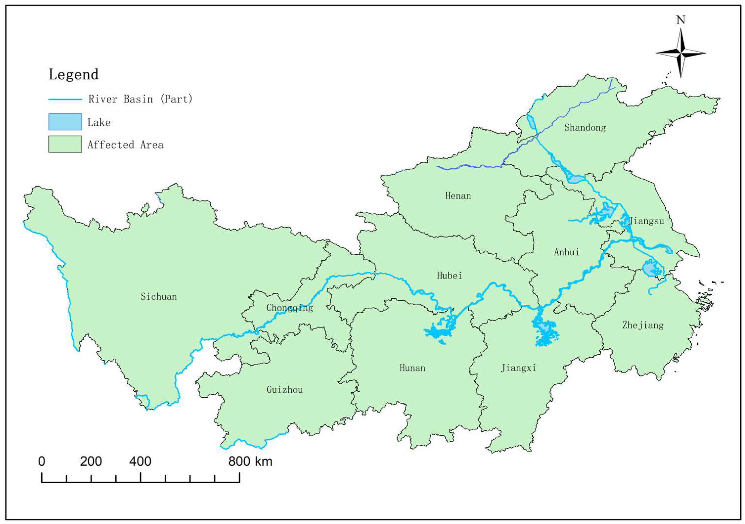
| Space | 42, Hubei |
| Topic | {({water level; Yangtze River; flood peak; the middle and lower reaches; a warning water level} which means the middle and lower reaches of the Yangtze River reach a warning water level, 3.12%); ({Hubei; Wuhan; Enshi; rainstorm; prewarning} which means cities of Hubei like Wuhan and Enshi issued rainstorm warnings, 2.49%); ({flood fighting; frontline; fighter; police; salute} which means we should tribute to the flood fighters, 2.40%); |
| Emotion | (0.33, 0.3586) |
| Disaster Condition | {Prewarning: Red 6; Orange 6; Yellow 4; Blue 1, Response: I 5; II 6;III 2; IV 1, Disaster Loss: {Human casualties: 4,550,900 Economy loss: 5,022,000,000 yuan Building damaged: 1795 Farmland loss: 80,000 acres} |
| Element | Information |
|---|---|
| Time | ((26 July 2021), (30 July 2021)) |
| Space | 42, Hubei |
| Topic | {({rainstorm; flooding; heavy rain; river; flood crossing} which means Heavy rains have caused many houses to be flooded, 0.46%); ({Hubei; Wuhan; Enshi; rainstorm; prewarning} which means cities of Hubei issued a rainstorm warning, 0.40%); ({flood fighting; frontline; fighter; police; salute} which means we should tribute to the flood fighters, 0.35%);} |
| Emotion | (0.16, 0.4113) |
| Disaster Condition | {Prewarning: Red 1; Orange 1; Yellow 1; Blue 1, Response: I 2; II 0; III 0; IV 1, Disaster Loss: {Human causalities: 160,000 Economy loss: 22,000,000 yuan Building damaged: No mention Farmland loss: No mention} |
| Status Entity | Element | Information |
|---|---|---|
| Disaster Entity i | Time | (15 July 2021) |
| Area | 42, Hubei | |
| Type | Response | |
| Rank | 2 | |
| Webid | [1692, 1693, 16999] | |
| Topic Entity j | Time | ((1 July 2021), (3 July 2021)) |
| Area | 42, Hubei | |
| Type | Prewarning | |
| Topic | Top topic: {water level; Yangtze River; flood peak; the middle and lower reaches; a warning water level} which means the middle and lower reaches of the Yangtze River reach a warning water level | |
| Webid | [16, 18, 32, 37, 38, 42, 48, 53, 57, 66, 70, 72] |
References
- Crooks, A.T.; Wise, S. GIS and agent-based models for humanitarian assistance. Comput. Environ. Urban Syst. 2013, 41, 100–111. [Google Scholar] [CrossRef]
- Johnson, B.A.; Estoque, R.C.; Li, X.C.; Kumar, P.; Dasgupta, R.; Avtar, R.; Magcale-Macandog, D.B. High-resolution urban change modeling and flood exposure estimation at a national scale using open geospatial data: A case study of the Philippines. Comput. Environ. Urban Syst. 2021, 90, 101704. [Google Scholar] [CrossRef]
- Ishiwatari, M.; Sasaki, D. Investing in flood protection in Asia: An empirical study focusing on the relationship between investment and damage. Prog. Disaster Sci. 2021, 12, 100197. [Google Scholar] [CrossRef]
- Uddin, K.; Matin, M.A. Potential flood hazard zonation and flood shelter suitability mapping for disaster risk mitigation in Bangladesh using geospatial technology. Prog. Disaster Sci. 2021, 11, 100185. [Google Scholar] [CrossRef]
- Songchon, C.; Wright, G.; Beevers, L. Quality assessment of crowdsourced social media data for urban flood management. Comput. Environ. Urban Syst. 2021, 90, 101690. [Google Scholar] [CrossRef]
- Shreevastav, B.B.; Tiwari, K.R.; Mandal, R.A.; Nepal, A. Assessing flood vulnerability on livelihood of the local community: A case from southern Bagmati corridor of Nepal. Prog. Disaster Sci. 2021, 12, 100199. [Google Scholar] [CrossRef]
- Ministry of Emergency Management of the People’s Republic of China. The Ministry of Emergency Management Announced the Top Ten Natural Disasters in the Country in 2021. Available online: https://www.mem.gov.cn/xw/yjglbgzdt/202201/t20220123_407199.shtml (accessed on 25 March 2022).
- Ministry of Emergency Management of the People’s Republic of China. The Ministry of Emergency Management Announced the Top Ten Natural Disasters in the Country in 2020. Available online: http://www.mem.gov.cn/xw/yjglbgzdt/202101/t20210102_376288.shtml (accessed on 25 March 2022).
- Yazdani, M.; Mojtahedi, M.; Loosemore, M.; Sanderson, D. A modelling framework to design an evacuation support system for healthcare infrastructures in response to major flood events. Prog. Disaster Sci. 2022, 13, 100218. [Google Scholar] [CrossRef]
- Hagen, J.S.; Cutler, A.; Trambauer, P.; Weerts, A.; Suarez, P.; Solomatine, D. Development and evaluation of flood forecasting models for forecast-based financing using a novel model suitability matrix. Prog. Disaster Sci. 2020, 6, 100076. [Google Scholar] [CrossRef]
- Yang, J.; Yu, M.; Qin, H.; Lu, M.; Yang, C. A Twitter data credibility framework—Hurricane Harvey as a use case. ISPRS Int. J. Geo-Inf. 2019, 8, 111. [Google Scholar] [CrossRef] [Green Version]
- Kwak, H.; Lee, C.; Park, H.; Moon, S. What is Twitter, a social network or a news media? In Proceedings of the International Conference on World Wide Web, Raleigh, NC, USA, 26–30 April 2010. [Google Scholar]
- Sakaki, T.; Okazaki, M.; Matsuo, Y. Earthquake shakes Twitter users: Real-time event detection by social sensors. In Proceedings of the 19th International Conference on World Wide Web, WWW 2010, Raleigh, NC, USA, 26–30 April 2010. [Google Scholar]
- Anderson, A.A. Expressions of resilience: Social media responses to a flooding event. Risk Anal. 2021, 41, 1600–1613. [Google Scholar] [CrossRef]
- Karmegam, D.; Ramamoorthy, S.; Mappillairaju, B. Near real time flood inundation mapping using social media data as an information source: A case study of 2015 Chennai flood. Geoenviron. Disasters 2021, 8, 25. [Google Scholar] [CrossRef]
- Yao, F.; Wang, Y. Tracking urban geo-topics based on dynamic topic model. Comput. Environ. Urban Syst. 2020, 79, 101419. [Google Scholar] [CrossRef]
- De Albuquerque, J.P.; Herfort, B.; Brenning, A.; Zipf, A. A geographic approach for combining social media and authoritative data towards identifying useful information for disaster management. Int. J. Geogr. Inf. Sci. 2015, 29, 667–689. [Google Scholar] [CrossRef] [Green Version]
- Tim, Y.; Pan, S.L.; Ractham, P.; Kaewkitipong, L. Digitally enabled disaster response: The emergence of social media as boundary objects in a flooding disaster. Inf. Syst. J. 2017, 27, 197–232. [Google Scholar] [CrossRef]
- Yu, M.; Yang, C.; Li, Y. Big data in natural disaster management: A review. Geosciences 2018, 8, 165. [Google Scholar] [CrossRef] [Green Version]
- Han, X.H.; Wang, J.L. Using social media to mine and analyze public sentiment during a disaster: A case study of the 2018 Shouguang city flood in China. ISPRS Int. J. Geo-Inf. 2019, 8, 185. [Google Scholar] [CrossRef] [Green Version]
- Mohan, D.A. Big data analytics: Recent achievements and new challenges. Int. J. Comput. Appl. Technol. Res. 2016, 5, 460–464. [Google Scholar] [CrossRef]
- Ogie, R.I.; Clarke, R.J.; Forehead, H.; Perez, P. Crowdsourced social media data for disaster management: Lessons from the PetaJakarta.org project. Comput. Environ. Urban Syst. 2019, 73, 108–117. [Google Scholar] [CrossRef]
- Granell, C.; Ostermann, F.O. Beyond data collection: Objectives and methods of research using VGI and geo-social media for disaster management. Comput. Environ. Urban Syst. 2016, 59, 231–243. [Google Scholar] [CrossRef]
- Allaire, M.C. Disaster loss and social media: Can online information increase flood resilience? Water Resour. Res. 2016, 52, 7408–7423. [Google Scholar] [CrossRef]
- Paradesi, S.M. Geotagging tweets using their content. In Proceedings of the Twenty-Fourth International Florida Artificial Intelligence Research Society Conference, Palm Beach, FL, USA, 18–20 May 2011. [Google Scholar]
- Gelernter, J.; Balaji, S. An algorithm for local geoparsing of microtext. GeoInformatica 2013, 17, 635–667. [Google Scholar] [CrossRef]
- Bakillah, M.; Li, R.-Y.; Liang, S.H.L. Geo-located community detection in Twitter with enhanced fast-greedy optimization of modularity: The case study of typhoon Haiyan. Int. J. Geogr. Inf. Sci. 2015, 29, 258–279. [Google Scholar] [CrossRef]
- Imran, M.; Elbassuoni, S.; Castillo, C.; Diaz, F.; Meier, P. Practical extraction of disaster-relevant information from social media. In Proceedings of the 22nd International Conference on World Wide Web (WWW), Rio de Janeiro, Brazil, 13–17 May 2013; pp. 1021–1024. [Google Scholar]
- Imran, M.; Mitra, P.; Castillo, C. Twitter as a lifeline: Human-annotated Twitter corpora for NLP of crisis-related messages. In Proceedings of the 10th International Conference on Language Resources and Evaluation (LREC), Portoroz, Slovenia, 23–28 May 2016; pp. 1638–1643. [Google Scholar]
- Pouyanfar, S.; Chen, S.-C. Automatic video event detection for imbalance data using enhanced ensemble deep learning. Int. J. Semant. Comput. 2017, 11, 85–109. [Google Scholar] [CrossRef]
- Kanth, A.K.; Chitra, P.; Sowmya, G.G. Deep learning-based assessment of flood severity using social media streams. Stoch. Environ. Res. Risk Assess. 2022, 36, 473–493. [Google Scholar] [CrossRef]
- Chen, Z.Y.; Mukherjee, A.; Liu, B.; Hsu, M.C.; Ghosh, R. Leveraging multi-domain prior knowledge in topic models. In Proceedings of the Twenty-Third International Joint Conference on Artificial Intelligence (IJCAI), Beijing, China, 3–9 August 2013. [Google Scholar]
- Chen, Z.Y.; Mukherjee, A.; Liu, B.; Hsu, M.C.; Castellanos, M.; Ghosh, R. Discovering coherent topics using general knowledge. In Proceedings of the 22nd ACM International Conference on Information and Knowledge Management (CIKM), San Francisco, CA, USA, 27 October–1 November 2013; pp. 209–218. [Google Scholar]
- Wang, Y.K.; Zhang, Z.B.; Su, S.; Zia, M.A. Topic-level bursty study for bursty topic detection in microblogs. In Proceedings of the 23rd Pacific-Asia Conference on Knowledge Discovery and Data Mining (PAKDD), Macau, China, 14–17 April 2019; pp. 97–109. [Google Scholar]
- Wang, Y.D.; Wang, T.; Ye, X.Y.; Zhu, J.Q.; Lee, J. Using social media for emergency response and urban sustainability: A case study of the 2012 Beijing rainstorm. Sustainability 2016, 8, 25. [Google Scholar] [CrossRef]
- Li, J.; He, Z.; Plaza, J.; Li, S.T.; Chen, J.F.; Wu, H.L.; Wang, Y.D.; Liu, Y. Social media: New perspectives to improve remote sensing for emergency response. Proc. IEEE 2017, 105, 1900–1912. [Google Scholar] [CrossRef]
- Saif, H.; He, Y.L.; Fernandez, M.; Alani, H. Contextual semantics for sentiment analysis of Twitter. Inf. Process. Manag. 2016, 52, 5–19. [Google Scholar] [CrossRef] [Green Version]
- Yin, J.; Karimi, S.; Lampert, A.; Cameron, M.; Robinson, B.; Power, R. Using social media to enhance emergency situation awareness. In Proceedings of the 1st International Workshop on Social Influence Analysis/24th International Joint Conference on Artificial Intelligence (IJCAI), Buenos Aires, Argentina, 25–31 July 2015; pp. 4234–4238. [Google Scholar]
- Herfort, B.; de Albuquerque, J.P.; Schelhorn, S.J.; Zipf, A. Exploring the geographical relations between social media and flood phenomena to improve situational awareness. In Proceedings of the 17th AGILE Conference on Geographic Information Science, Castellon, Spain, 3–6 June 2014; pp. 55–71. [Google Scholar]
- Chae, J.; Thom, D.; Jang, Y.; Kim, S.; Ertl, T.; Ebert, D.S. Public behavior response analysis in disaster events utilizing visual analytics of microblog data. Comput. Graph. 2014, 38, 51–60. [Google Scholar] [CrossRef]
- Rosser, J.F.; Leibovici, D.G.; Jackson, M.J. Rapid flood inundation mapping using social media, remote sensing and topographic data. Nat. Hazards 2017, 87, 103–120. [Google Scholar] [CrossRef] [Green Version]
- Li, Z.L.; Wang, C.Z.; Emrich, C.T.; Guo, D.S. A novel approach to leveraging social media for rapid flood mapping: A case study of the 2015 South Carolina floods. Cartogr. Geogr. Inf. Sci. 2018, 45, 97–110. [Google Scholar] [CrossRef]
- Xu, L.; Ma, A. Coarse-to-fine waterlogging probability assessment based on remote sensing image and social media data. Geo-Spat. Inf. Sci. 2021, 24, 279–301. [Google Scholar] [CrossRef]
- Wang, Z.Y.; Ye, X.Y. Social media analytics for natural disaster management. Int. J. Geogr. Inf. Sci. 2018, 32, 49–72. [Google Scholar] [CrossRef]
- Huang, Q.Y.; Xiao, Y. Geographic situational awareness: Mining tweets for disaster preparedness, emergency response, impact, and recovery. ISPRS Int. J. Geo-Inf. 2015, 4, 1549–1568. [Google Scholar] [CrossRef] [Green Version]
- Ibias, A.; Núñez, M.; Hierons, R.M. Using mutual information to test from Finite State Machines: Test suite selection. Inf. Softw. Technol. 2021, 132, 106498. [Google Scholar] [CrossRef]
- Guan, X.Y.; Chen, C. Using social media data to understand and assess disasters. Nat. Hazards 2014, 74, 837–850. [Google Scholar] [CrossRef]
- Kim, J.; Hastak, M. Social network analysis: Characteristics of online social networks after a disaster. Int. J. Inf. Manag. 2018, 38, 86–96. [Google Scholar] [CrossRef]
- Jongman, B.; Wagemaker, J.; Romero, B.R.; De Perez, E.C. Early flood detection for rapid humanitarian response: Harnessing near real-time satellite and Twitter signals. ISPRS Int. J. Geo-Inf. 2015, 4, 2246–2266. [Google Scholar] [CrossRef] [Green Version]
- Liu, Z.; Qiu, Q.; Li, J.; Wang, L.; Plaza, A. Geographic optimal transport for heterogeneous data: Fusing remote sensing and social media. IEEE Trans. Geosci. Remote Sens. 2020, 59, 6935–6945. [Google Scholar] [CrossRef]


| Component | Name | Description |
|---|---|---|
| Prewarning | ID | Unique identifier |
| Type | The type of prewarning, like heavy rain or flood | |
| Rank | The rank of prewarning | |
| Time | The time when the warning was issued | |
| Area | The location involved in the warning | |
| Webid | The id set of involved text | |
| Response | ID | Unique identifier |
| Rank | The rank of response | |
| Time | The time when the response was issued | |
| Area | The location involved in the response | |
| Webid | The id set of involved text | |
| Disaster Loss | ID | Unique identifier |
| Time | The time when the disaster loss was issued | |
| Area | The location involved in the disaster | |
| SP | Number of human casualties in the disaster | |
| EL | Economic losses in the disaster | |
| FL | Loss of farmland in the disaster | |
| BL | Loss of buildings in the disaster | |
| Webid | The id set of involved text |
Publisher’s Note: MDPI stays neutral with regard to jurisdictional claims in published maps and institutional affiliations. |
© 2022 by the authors. Licensee MDPI, Basel, Switzerland. This article is an open access article distributed under the terms and conditions of the Creative Commons Attribution (CC BY) license (https://creativecommons.org/licenses/by/4.0/).
Share and Cite
Liu, Y.; Li, R.; Wang, S.; Wu, H.; Gui, Z. Deducing Flood Development Process Using Social Media: An Event-Based and Multi-Level Modeling Approach. ISPRS Int. J. Geo-Inf. 2022, 11, 306. https://doi.org/10.3390/ijgi11050306
Liu Y, Li R, Wang S, Wu H, Gui Z. Deducing Flood Development Process Using Social Media: An Event-Based and Multi-Level Modeling Approach. ISPRS International Journal of Geo-Information. 2022; 11(5):306. https://doi.org/10.3390/ijgi11050306
Chicago/Turabian StyleLiu, Yang, Rui Li, Shunli Wang, Huayi Wu, and Zhipeng Gui. 2022. "Deducing Flood Development Process Using Social Media: An Event-Based and Multi-Level Modeling Approach" ISPRS International Journal of Geo-Information 11, no. 5: 306. https://doi.org/10.3390/ijgi11050306
APA StyleLiu, Y., Li, R., Wang, S., Wu, H., & Gui, Z. (2022). Deducing Flood Development Process Using Social Media: An Event-Based and Multi-Level Modeling Approach. ISPRS International Journal of Geo-Information, 11(5), 306. https://doi.org/10.3390/ijgi11050306