GIScience and Historical Cartography for Evaluating Land Use Changes and Resulting Effects on Carbon Balance
Abstract
:1. Introduction
1.1. New Spatial Planning Techniques
1.2. Historical Cartography for Land Transformation Analyses
2. Materials and Methods
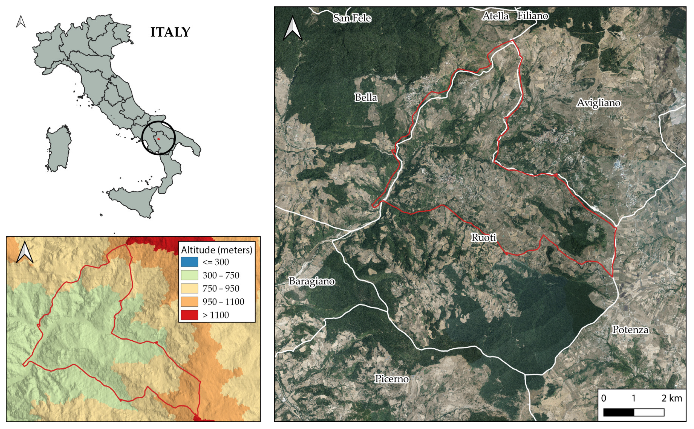
2.1. Study Area

2.2. The Cartography
2.2.1. 1848 Historical Map
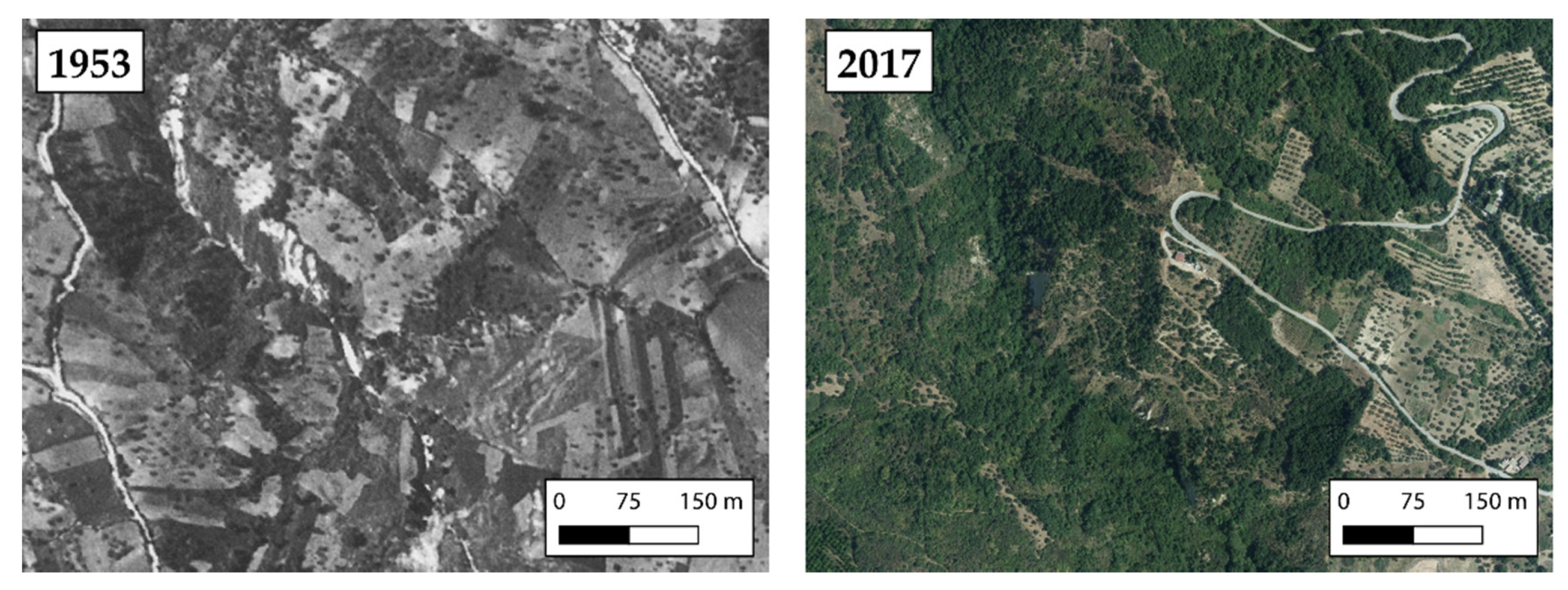
2.2.2. 1953 Aerial Photos
2.2.3. 2017 Orthophotos
2.3. Land Use Data Elaboration
- -
- Woodland: It includes forests composed primarily of trees and transitional woodland/shrublands and may represent both forest degradation and forest regeneration/recolonization. It also includes scrubby or herbaceous vegetation with scattered trees.
- -
- Arable land: Cultivated land with different crops (i.e., in this study: cereals);
- -
- Pastures: Often situated in impervious and rocky areas, pastures’ vegetation consists mainly of grasses and shrubs, with interspersed legumes and other forbs (non-grass herbaceous plants).
- -
- Vineyards: Areas planted with vines;
- -
- Olive groves: Areas planted with olive trees;
- -
- Built-up area: is defined as the presence of buildings (roofed structures) i.e., the city, the ancient buildings, and those dating from recent expansion, as well as buildings and farms in rural areas that occupy most of the present built-up area. Buildings, roads, and artificially paved areas are associated with vegetated areas and bare soils that occupy irregular but significant areas.
2.4. Carbon Dioxide Calculation
3. Results and Discussions
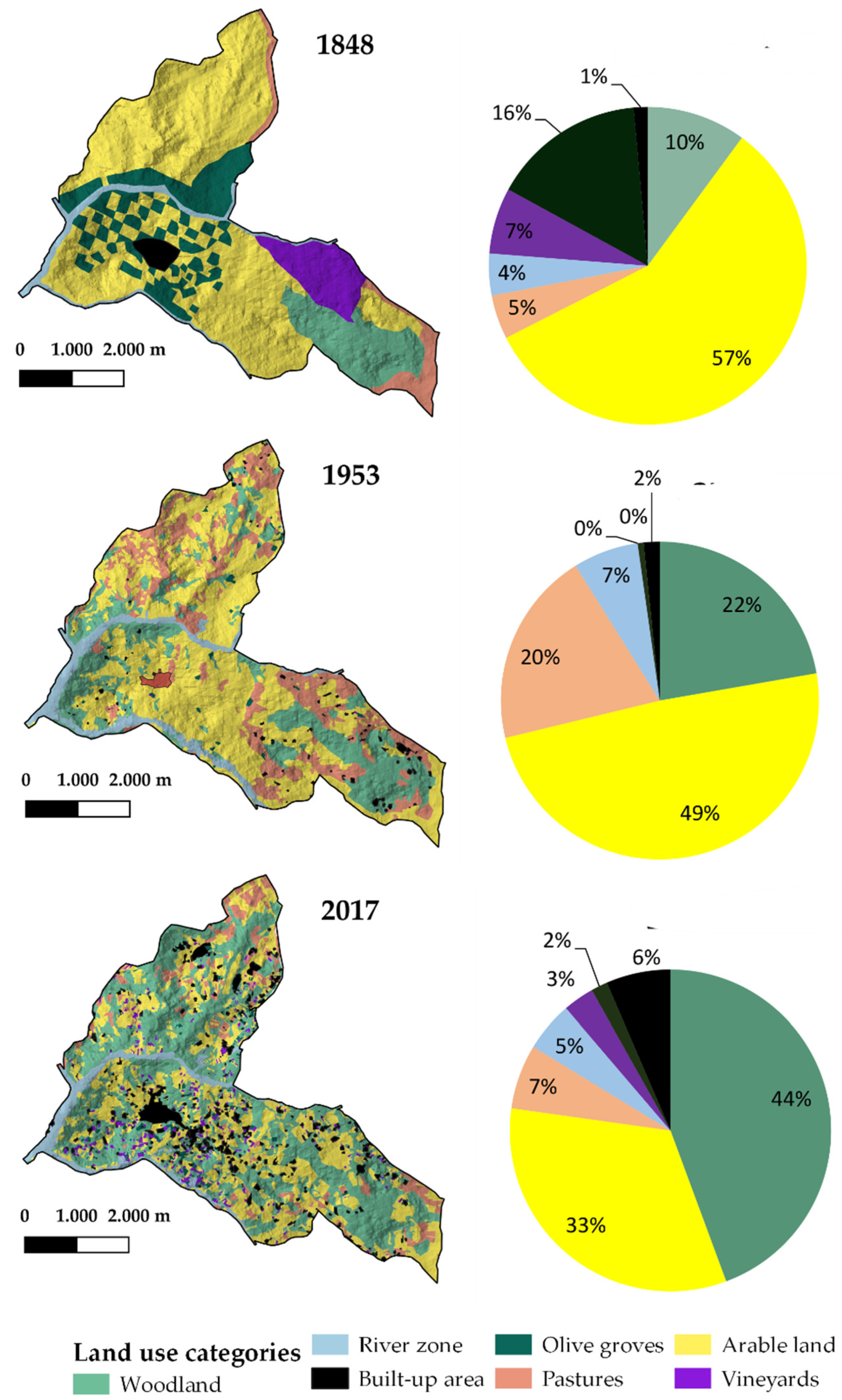
3.1. Land Use
- The depopulation of small villages, with the consequent abandonment of cultivated areas, especially in Basilicata, which made up of fragmented agricultural properties and very small farms [59]
- The economic crisis of the agricultural sector at the national level, which has led to the abandonment of the less productive areas, which is disadvantageous from an economic point of view.
3.2. Carbon Dioxide Balance
4. Conclusions
Author Contributions
Funding
Institutional Review Board Statement
Informed Consent Statement
Data Availability Statement
Conflicts of Interest
References
- Pavid, K. What is the Anthropocene and why does it matter? Nat. Hist. Mus. 2021. Available online: https://www.nhm.ac.uk/discover/what-is-the-anthropocene.html (accessed on 14 February 2022).
- Zari, M.P.; Mainguy, G. Ecosystem Services Analysis in Response to Biodiversity Loss Caused by The Built Environmet. Sapiens 2014, 7. Available online: http://journals.openedition.org/sapiens/1684 (accessed on 1 January 2022).
- McDonald, G.T. Multidisciplinary Land Use Planning. J. Environ. Educ. 1984, 15, 36–41. [Google Scholar] [CrossRef]
- Santoro, A.; Venturi, M.; Piras, F.; Fiore, B.; Corrieri, F.; Agnoletti, M. Forest area changes in Cinque Terre National Park in the last 80 years. Consequences on landslides and forest fire risks. Land 2021, 10, 293. [Google Scholar] [CrossRef]
- Slobodian, L.; Vidal, A.; Saint-Laurent, C. Policies That Support Forest Landscape Restoration: What They Look Like and How They Work; IUCN: Gland, Switzerland, 2020. [Google Scholar]
- Manniello, C.; Statuto, D.; Di Pasquale, A.; Giuratrabocchetti, G.; Picuno, P. Planning the flows of residual biomass produced by wineries for the preservation of the rural landscape. Sustainability 2020, 12, 847. [Google Scholar] [CrossRef] [Green Version]
- Balestrieri, M.; Ganciu, A. Landscape Changes in Rural Areas: A Focus on Sardinian Territory. Sustainability 2018, 10, 123. [Google Scholar] [CrossRef] [Green Version]
- Pindozzi, S.; Cervelli, E.; Capolupo, A.; Okello, C.; Boccia, L. Using historical maps to analyze two hundred years of land cover changes: Case study of Sorrento peninsula (south Italy). Cartogr. Geogr. Inf. Sci. 2016, 43, 250–265. [Google Scholar] [CrossRef]
- Amici, V.; Maccherini, S.; Santi, E.; Torri, D.; Vergari, F.; Del Monte, M. Long-term patterns of change in a vanishing cultural landscape: A GIS-based assessment. Ecol. Inform. 2017, 37, 38–51. [Google Scholar] [CrossRef]
- Houghton, R.A.; Hackler, J.L. Emissions of carbon from forestry and land use change in tropical Asia. Glob. Chang. Biol. 1999, 5, 481–492. [Google Scholar] [CrossRef]
- Paci, M. Forest Ecology; Edagricole: Bologna, Italy, 1997. [Google Scholar]
- Ministero dell’Ambiente (Italian Environmental Ministry). 1999. Available online: http:/www.minambiente.it (accessed on 20 October 2021).
- Tassinari, P. A Methodological Contribution to Landscape Design and Improvement. Agric. Eng. Int. CIGR J. 2006, VIII, 1–17. [Google Scholar]
- Adinarayana, J.; Laurenson, M.; Ninomiya, S. Web-based Decision Support System for Rural Land Use Planning—WebLUP—A Prototype. Agric. Eng. Int. CIGR J. 2006, VIII, 1–13. [Google Scholar]
- Cillis, G.; Statuto, D.; Picuno, P. Historical maps processed into a GIS for the assessment of forest landscape dynamics. In Proceedings of the Public Recreation and Landscape Protection—With Sense Hand in Hand? Krtiny, Czech Republic, 13–15 May 2019; pp. 180–184. [Google Scholar]
- Massoud, M.A.; El-Fadel, M.; Scrimshaw, M.D.; Lester, J.N. Land use Impact on the Spatial and Seasonal Variation of Contaminant Loads to Abou Ali River and Its Coastal Zone in North Lebanon. CIGR J. Sci. Res. Dev. 2004, 1–18. [Google Scholar]
- Santé-Riveira, I.; Crecente-Maseda, R.; Miranda-Barrós, D. GIS-based planning support system for rural land-use allocation. Comput. Electron. Agric. 2008, 63, 257–273. [Google Scholar] [CrossRef]
- Bender, O.; Boehmer, H.J.; Jens, D.; Schumacher, K.P. Analysis of land-use change in a sector of Upper Franconia (Bavaria, Germany) since 1850 using land register records. Landsc. Ecol. 2005, 20, 149–163. [Google Scholar] [CrossRef]
- Cillis, G.; Statuto, D.; Picuno, P. Historical GIS as a Tool for Monitoring, Preserving and Planning Forest Landscape: A Case Study in a Mediterranean Region. Land 2021, 10, 851. [Google Scholar] [CrossRef]
- Tortora, A.; Statuto, D.; Picuno, P. Rural landscape planning through spatial modelling and image processing of historical maps. Land Use Policy 2014, 42, 71–82. [Google Scholar] [CrossRef]
- Hernández, J.; García, L.; Ayuga, F. Integration methodologies for visual impact assessment of rural buildings by geographic information systems. Biosyst. Eng. 2004, 88, 255–263. [Google Scholar] [CrossRef]
- Statuto, D.; Tortora, A.; Picuno, P. A GIS approach for the quantification of forest and agricultural biomass in the Basilicata region. J. Agric. Eng. 2013, 44, 627–631. [Google Scholar] [CrossRef]
- Kim, Y.; Lee, J.; Kim, J.; Nakajima, N. The Disparity in Transit Travel Time between Koreans and Japanese in 1930s Colonial Seoul. Transp. Find. 2021. [Google Scholar] [CrossRef]
- Ishikawa, K.; Nakayama, D. Estimation of origin-destination flows of passenger cars in 1925 in old Tokyo city, Japan. ISPRS Int. J. Geo-Inf. 2019, 8, 472. [Google Scholar] [CrossRef] [Green Version]
- Kienast, F. Analysis of historic landscape patterns with a Geographical Information System: A methodological outline. Landsc. Ecol. 1993, 8, 103–118. [Google Scholar] [CrossRef]
- Petit, C.; Lambin, E.F. Long-term land-cover changes in the Belgian Ardennes (1775–1929): Model-based reconstruction vs. Historical maps. Glob. Chang. Biol. 2002, 8, 616–630. [Google Scholar] [CrossRef]
- Brandolini, F.; Reynard, E.; Pelfini, M. Multi-temporal mapping of the Upper Rhone Valley (Valais, Switzerland): Fluvial landscape changes at the end of the Little Ice Age (18th–19th centuries). J. Maps 2020, 16, 212–221. [Google Scholar] [CrossRef] [Green Version]
- Dai Prà, E. For a new applied historical geography: Prolegomena to a center for the study, the enhancement and the active fruition of historical cartography. Boll. Assoc. Ital. Cartogr. 2018, 162, 108–122. [Google Scholar]
- Statuto, D.; Cillis, G.; Picuno, P. Visual quality indicators for assessing landscape characteristics and managing its protection. In Proceedings of the Public Recreation and Landscape Protection—With Sense Hand in Hand? Křtiny, Czech Republic, 13–15 May 2019; pp. 476–480. Available online: https://www.researchgate.net/publication/333192079_VISUAL_QUALITY_INDICATORS_FOR_ASSESSING_LANDSCAPE_CHARACTERISTICS_AND_MANAGING_ITS_PROTECTION (accessed on 12 September 2021).
- Devátý, J.; Dostál, T.; Hösl, R.; Krása, J.; Strauss, P. Effects of historical land use and land pattern changes on soil erosion—Case studies from Lower Austria and Central Bohemia. Land Use Policy 2019, 82, 674–685. [Google Scholar] [CrossRef]
- Pärtel, M.; Mändla, R.; Zobel, M. Landscape history of a calcareous (alvar) grassland in Hanila, western Estonia, during the last three hundred years. Landsc. Ecol. 1999, 14, 187–196. [Google Scholar] [CrossRef]
- Jordan, G.; Van Rompaey, A.; Szilassi, P.; Csillag, G.; Mannaerts, C.; Woldai, T. Historical land use changes and their impact on sediment fluxes in the Balaton basin (Hungary). Agric. Ecosyst. Environ. 2005, 108, 119–133. [Google Scholar] [CrossRef]
- Bender, O.; Boehmer, H.J.; Jens, D.; Schumacher, K.P. Using GIS to analyse longterm cultural landscape change in Southern Germany. Landsc. Urban Plan. 2005, 70, 111–125. [Google Scholar] [CrossRef]
- Stäuble, S.; Martin, S.; Reynard, E. Historical mapping for landscape reconstruction: Examples from the Canton of Valais (Switzerland). In Proceedings of the Mountain Mapping and Visualisation: 6th ICA Mountain Cartography Workshop, Lenk, Switzerland, 11–15 February 2008; pp. 211–217. [Google Scholar]
- Gimmi, U.; Lachat, T.; Bürgi, M. Reconstructing the collapse of wetland networks in the Swiss lowlands 1850–2000. Landsc. Ecol. 2011, 26, 1071–1083. [Google Scholar] [CrossRef]
- Williams, J.H. The Archeolgoy of Kent to AD 800; Boydell Press: Woodbridge, UK, 2007; Volume 8, p. 304. [Google Scholar]
- Barclay, G. Farmers, Temples and Tombs (Making of Scotland); Birlinn Press: Edinburgh, UK, 2005; p. 64. [Google Scholar]
- Skaloš, J.; Weber, M.; Lipský, Z. Using old military survey maps and orthophotograph maps to analyse long-term land cover changes: Case study (Czech Republic). Appl. Geogr. 2011, 31, 426–438. [Google Scholar] [CrossRef]
- Yang, Y.; Zhang, S.; Yang, J.; Chang, L.; Bu, K.; Xing, X. A review of historical reconstruction methods of land use/land cover. J. Geogr. Sci. 2014, 24, 746–766. [Google Scholar] [CrossRef]
- Domaas, S.T. The reconstruction of past patterns of tilled fields from historical cadastral maps using GIS. Landsc. Res. 2007, 32, 23–43. [Google Scholar] [CrossRef]
- Trpáková, I. The use of historical sources and their ecological interpretation in the course of almost two centuries—A literature review. J. Landsc. Stud. 2009, 2, 97–119. [Google Scholar]
- Lieskovsky, J.; Kaim, D.; Balazs, P.; Boltiziair, M.; Chmiel, M.; Grabska, E. Historical land use dataset of the Carpathian region (1819–1980). J. Maps 2018, 14, 644–651. [Google Scholar] [CrossRef] [Green Version]
- Valent, P.; Roncak, P.; Maliarikova, R.; Behan, S. Utilisation of Historical Maps in the Land Use Change Impact Studies: A Case Study from Myjava River Basin. J. Civ. Eng. 2016, 24, 15–26. [Google Scholar]
- Chen, Y.Y.; Huang, W.; Wuang, W.H.; Juang, J.Y.; Hong, J.S.; kato, T.; Luyssaert, S. Reconstructing Taiwan’s land cover changes between 1904 and 2015 from historical maps and satellite images. Sci. Rep. 2019, 9, 3643. [Google Scholar] [CrossRef] [PubMed] [Green Version]
- Atlante Cartografico dell’Artigianato; S.I. ACI: Rome, Italy, 1985.
- APT Basilicata. Available online: aptbasilicata.it (accessed on 16 October 2021).
- RSDI. Infrastruttura Regionale dei Dati Spaziali della Regione Basilicata. Available online: https://rsdi.regione.basilicata.it/ (accessed on 15 September 2021).
- Mastronunzio, M.; Dai, P.E. Editing historical maps: Comparative cartography using maps as tools. e-Perimetron 2016, 11, 183–195. [Google Scholar]
- Balletti, C. Georeference in the analysis of the geometric content of early maps. e-Perimetron 2006, 1, 32–42. [Google Scholar]
- Picuno, P.; Cillis, G.; Statuto, D. Investigating the time evolution of a rural landscape: How historical maps may provide environmental information when processed using a Gis. Ecol. Eng. 2019, 139, 105580. [Google Scholar] [CrossRef]
- Brovelli, M.A.; Minghini, M. Georeferencing old maps: A polynomial-based approach for Como historical cadastres. e-Perimetron 2012, 7, 97–110. [Google Scholar]
- Podobnikar, T. Georeferencing and quality assessment of josephine survey maps for the mountainous region in the Triglav National Park. Acta Geod. Geophys. Hung. 2009, 44, 49–66. [Google Scholar] [CrossRef] [Green Version]
- Cillis, G.; Statuto, P.; Picuno, P. Integrating remote-sensed and historical geodata to assess interactions between rural buildings and agroforestry land. J. Environ. Eng. Landsc. 2021, 29, 229–243. [Google Scholar] [CrossRef]
- Masera, O.R.; Garza-Caligaris, J.F.; Kanninen, M.; Karjalainen, T.; Liski, J.; Nabuurs, G.J.; Pussinen, A.; de Jong, B.H.J.; Mohren, G.M.J. Modeling carbon sequestration in afforestation, agroforestry and forest management projects: The CO2FIX V.2 approach. Ecol. Model. 2003, 164, 177–199. [Google Scholar] [CrossRef]
- Mohren, G.M.J.; Garza Caligaris, J.F.; Masera, O.; Kanninen, M.; Karjalainen, T.; Pussinen, A.; Nabuurs, G.J. CO2FIX for Windows: A dynamic model of the CO2-fixation in forests. IBN Sci. Contrib. 1999, 99, 1–33. [Google Scholar]
- Xiloyannis, C.; Sofo, A.; Nuzzo, V.; Palese, A.M.; Celano, G.; Zukowskyj, P.; Dichio, B. Net CO2 storage in Mediterranean olive and peach orchards. Sci. Hortic. 2005, 107, 17–24. [Google Scholar]
- Basilicata Environmental Year 2013: Basilicata Region. Available online: https://www.regione.basilicata.it/giuntacma/files/docs/DOCUMENT_FILE_2975276.pdf (accessed on 25 January 2022).
- Commission Regulation (EEC) No 1273/88 of 29 April 1988 laying down criteria for delimiting the regions or areas which may be exempted from the schemes for the set-aside of arable land, extensification and the conversion of production. Off. J. L 1988, 121, 41. Available online: https://eur-lex.europa.eu/legal-content/EN/TXT/?uri=CELEX:31988R1273 (accessed on 5 February 2022).
- ISTAT (Italian National Institute for Statistic). 6th General Census of Agriculture. Land Use of the Agricultural Unit; ISTAT: Rome, Italy, 2011; Available online: http://censimentoagricoltura.istat.it/ (accessed on 16 October 2021).


| 1848 | 1953 | 2017 | ||||
|---|---|---|---|---|---|---|
| Land Use | Area (ha) | Percentage (%) | Area (ha) | Percentage (%) | Area (ha) | Percentage (%) |
| Woodland | 254.51 | 10.09 | 561.3 | 22.26 | 1118.59 | 44.36 |
| Arable land | 1447.56 | 57.41 | 1234.62 | 48.96 | 828.6 | 32.86 |
| Pastures | 113.08 | 4.48 | 501.41 | 19.88 | 163.81 | 6.5 |
| River zones | 107.5 | 4.26 | 167.48 | 6.64 | 126.62 | 5.02 |
| Vineyards | 169.57 | 6.72 | 0.43 | 0.02 | 78.64 | 3.12 |
| Olive groves | 393.24 | 15.59 | 15.13 | 0.6 | 41.98 | 1.66 |
| Built-up area | 36.15 | 1.43 | 41.25 | 1.64 | 163.39 | 6.48 |
| 2521.62 | 2521.62 | 2521.62 | ||||
| Year | Woodland | Orchard | Arable Land | Shrubland | Urban | ||||||
|---|---|---|---|---|---|---|---|---|---|---|---|
| Area (ha) | Annual Fixation (MgC/ha/yr) | Area (ha) | Annual Fixation (MgC/ha/yr) | Area (ha) | Annual Fixation (MgC/ha/yr) | Area (ha) | Annual Fixation (MgC/ha/yr) | Area (ha) | Annual Fixation (MgC/ha/yr) | Total Annual Fixation (MgC/ha/yr) | |
| 1848 | 254.5 | 6262.8 | 562.8 | 4080.4 | 1447 | 5211.2 | 220.5 | 606.6 | 36.1 | −542.2 | 15,718.9 |
| 1953 | 561.3 | 14032.6 | 15.56 | 112.8 | 1234 | 4444.6 | 668.8 | 1839.4 | 41.2 | −618.8 | 19,810.7 |
| 2017 | 1118.5 | 27,964.8 | 120.6 | 874.5 | 828.6 | 2982.9 | 290.4 | 798.6 | 163 | −2450.9 | 30,170.1 |
Publisher’s Note: MDPI stays neutral with regard to jurisdictional claims in published maps and institutional affiliations. |
© 2022 by the authors. Licensee MDPI, Basel, Switzerland. This article is an open access article distributed under the terms and conditions of the Creative Commons Attribution (CC BY) license (https://creativecommons.org/licenses/by/4.0/).
Share and Cite
Manniello, C.; Cillis, G.; Statuto, D.; Di Pasquale, A.; Picuno, P. GIScience and Historical Cartography for Evaluating Land Use Changes and Resulting Effects on Carbon Balance. ISPRS Int. J. Geo-Inf. 2022, 11, 179. https://doi.org/10.3390/ijgi11030179
Manniello C, Cillis G, Statuto D, Di Pasquale A, Picuno P. GIScience and Historical Cartography for Evaluating Land Use Changes and Resulting Effects on Carbon Balance. ISPRS International Journal of Geo-Information. 2022; 11(3):179. https://doi.org/10.3390/ijgi11030179
Chicago/Turabian StyleManniello, Canio, Giuseppe Cillis, Dina Statuto, Andrea Di Pasquale, and Pietro Picuno. 2022. "GIScience and Historical Cartography for Evaluating Land Use Changes and Resulting Effects on Carbon Balance" ISPRS International Journal of Geo-Information 11, no. 3: 179. https://doi.org/10.3390/ijgi11030179
APA StyleManniello, C., Cillis, G., Statuto, D., Di Pasquale, A., & Picuno, P. (2022). GIScience and Historical Cartography for Evaluating Land Use Changes and Resulting Effects on Carbon Balance. ISPRS International Journal of Geo-Information, 11(3), 179. https://doi.org/10.3390/ijgi11030179


