Abstract
In this study, we explored the characteristics of thermal anomalies other than biomass burning to establish a zone map of false-positive active fires to support efficient ground validation for firefighters. We used the ASCII file of VIIRS active fire data (VNP14IMGML), which provides attributes of thermal anomalies every month from 2012 to 2020 in Indonesia. The characteristics of thermal anomalies other than biomass burning were explored using fire radiative power (FRP) values, confidence levels of active fire, fire pixel areas, and their allocations to permanent geographical features (i.e., volcano, river, lake, coastal line, road, and industrial/settlement areas). The Tukey test showed that there was a significant difference between the mean FRP values of the other thermal anomalies, type-1 (active volcano), type-2 (other static land sources), and type-3 (detection over water/offshore), at a confidence level of 95%. Most thermal anomalies other than biomass burning were in the nominal confidence level with a fire pixel area of 0.21 km2. High spatial images validated these thermal anomaly types as false positives of biomass burning. A zone map of potential false-positive active fire for biomass burning was established in this study by referring to the allocation of thermal anomalies from permanent geographical features. Implementing the zone map removed approximately 13% of the VIIRS active fires as the false positive of biomass burning. Insights gleaned through this study will support efficient ground validation of actual forest/land fires.
1. Introduction
Satellite-based active fire products, especially from low-spatial-resolution sensors such as Moderate Resolution Imaging Spectroradiometer (MODIS) aboard the Terra-Aqua satellite and the Visible Infrared Imaging Radiometer Suite (VIIRS) aboard the Suomi National Polar-orbiting Partnership (SNPP), have been widely used for global fire monitoring [1,2,3,4,5,6,7,8,9]. The first algorithm for active fire detection from low spatial resolution was developed by [10] for measuring the spectral radiant temperature and sub-pixel hotspot in a uniform pixel, utilizing the middle infrared and thermal infrared spectral from Advanced Very High Resolution Radiometer (AVHRR) data. This method was further developed from the fixed threshold to the contextual approach to overcome the background pixel variation and implemented with some improvements related to sensor specifications. The contextual approach has been implemented in many sensors, producing contemporary daily monitoring of active fire using low-spatial-resolution data, for example MODIS, VIIRS, Geostationary Operational Environmental Satellite System (GOES), Meteosat-Spinning Enhanced Visible and InfraRed Imager (MSG-SEVIRI), Sentinel-3 Sea and Land Surface Temperature Radiometer (SLSTR), and Himawari-8/9 Advance Himawari Imager (AHI) data [11,12,13,14,15,16,17,18].
The low-spatial-resolution data with its high-revisit-time observation capability enables daily active fire information, which supports daily ground monitoring for firefighters. Ground monitoring or validation of active fire information is challenging owing to factors such as inaccessibility, high cost, and high risk in term of safety [19,20,21]. Firefighters sometimes encounter false alarms from active fire information in their ground validation. The permanent false-positive objects in space-based fire information need to be well documented to allow firefighters to effectively validate fires over large areas. Such an approach is especially important within the context of limited resources and remote or underdeveloped areas. Assessments of active fire data on thermal anomalies other than biomass burning have been conducted by [5,6,7]. According to Coskuner [1], 7.1% of MODIS hotspots and 21.8% of VIIRS hotspots occurred in urban/built-up areas, while [6] found that 1.2% of commission errors of VIIRS daytime hotspots occurred over bright reflective rooftops. Night-time data may also detect heat sources, such as active volcanoes, gas flares, and iron mills, as hotspots [6]. In the Indonesian region, the false positives related to other thermal anomalies of VIIRS active fire data were found over open-land/bare-land (<5%), gas flares (9%), and on bright objects, such as mining areas and building rooftops (<5%) [7].
Permanent false-positive objects can re-occur in the detection of active fire owing to their similarity in spectral reflectance and brightness temperature to those objects that are on fire. Instead of fire temperature, fire radiative power (FRP) is an essential variable for representing the instantaneous released energy (MW/pixel) from a burning fire pixel. The FRP is generated from the radiance of the 4 µm band. The 4 µm band is usually available on low-spatial-resolution sensors such as GOES, MSG-SEVIRI, VIIRS, MODIS, AVHRR, SLSTR, AHI, Hot Spot Recognition System–Bi-spectral Infrared Detector (HSRS-BIRD), and Technology Experiment Carrier-1 (TET-1). FRP is mainly used to investigate fire characteristics, behavior, and emission [22,23,24,25,26,27,28,29,30,31,32]. There are a limited number of studies exploring the difference between the FRP of biomass burning and other thermal anomalies, especially in the tropics, where the typical atmosphere and environments may infer the variety of FRP.
VIIRS produces active fire data, VNP14IMGML, which provides types attributed to thermal anomalies and FRP [30]. These data are a potential resource for removing false-alarm objects from active fire information to support effective biomass burning monitoring in the field. However, the accuracy of the false-alarm objects on VNP14IMGML must be assessed because a persistent hotspot may occur in the same area due to traditional local land clearing by fire and peatland degradation in the tropics, which is prone to fires during droughts [33,34,35]. The objectives of this study are (1) to explore and assess the characteristics of the false positives that existed in active fire products from the low spatial resolution (VIIRS) in the Indonesian region, (2) to propose a zone map of the potential false-positive active fire over Indonesia based on characteristics found in the other thermal anomalies of VIIRS active fire data, and (3) to implement the proposed zone map to eliminate false-positive active fire data. Mapping false-positive sources of biomass burning may support the development of an effective ground validation strategy.
2. Materials and Methods
2.1. Data Used in This Study
2.1.1. VIIRS Active Fire
We selected the low spatial resolution of active fire products from VIIRS, which is widely used for active global fire monitoring [6,30]. The VIIRS instrument was launched aboard the SNPP satellite on 28 October 2011, and produced active fire data since 19 January 2012 [30], while VIIRS aboard the NOAA-20 started on 19 November 2017. The VIIRS-SNPP spans the equator at approximately 1:30 PM (ascending node) and 1:30 AM (descending node). The 22 spectral bands of VIIRS range from visible, shortwave infrared, and mid-infrared to thermal infrared at 375 m (I-bands) and 750 m (M-bands), with additional day and night bands at 750 m. The VIIRS active fire algorithm was developed in [6] based on the MODIS active fire algorithm using the multispectral contextual method [12,22]. The bands used for the active fire algorithm are listed in Table 1.

Table 1.
Spectral bands used to generate VIIRS active fire [6].
The Level-2 VIIRS active fire from the I-bands at 375 m was termed VNP14IMG. VNP14IMGML is the ASCII active fire of VIIRS Level-2 data which is available as vector points containing coordinates of active fires and the attributed types of thermal anomalies, that is, presumed biomass fire (type-0), active volcanoes (type-1), other static land sources (type-2), and offshore detection including all detection over water (type-3). It also provides information on other parameters, such as FRP, VIIRS M-band fire pixel area (km2), and confidence class (0–100%) [6]. The data were made available on a monthly basis from the University of Maryland’s server (Fuoco.geog.umd.edu). We used the VNP14IMGML data from 2012 to 2021 in Indonesia. The calculation of VIIRS FRP is based on the Middle Infrared (MIR) radiance algorithm as follows [16,27]:
where FRP is in unit MW, L4 is the VIIRS I4 spectral radiance of the fire pixel (W m−2 sr −1 μm−1), is the mean background radiance, is the area of the VIIRS pixel (m2), σ is the Stefan–Boltzmann constant (5.6704 × 10⁻⁸ W m−2 K−4), is the atmospheric transmittance of the I4 spectral channel, and the empirical constant of can be calculated based on the power physic law of radiance and temperature (3.2146 × 10⁻⁹ W m−2 sr−1 μm−1 K−4) for VIIRS [36]. To analyze the thermal anomalies of the VIIRS active fire, the Digital Elevation Model from Shuttle Radar Topography Mission data (DEM-SRTM)—National Aeronautics and Space Administration (NASA) at 30 m spatial resolution was used for topographical analysis to characterize the landscape terrain for each type of thermal anomaly.
2.1.2. High-Resolution Images
High-resolution data from Google Earth, ESRI, and PlanetScope images were used randomly to confirm the object of false-positive fires from the VIIRS active fire. The same-day acquisition of high-resolution images with VIIRS data was randomly selected from the PlanetScope data at 3.7 m spatial resolution. Images of high-resolution sources complement each other if cloud cover obscures the sampling areas.
2.1.3. Geospatial Supporting Data
In addition to satellite data, we used the Geographic Information System (GIS) vector polylines of island boundaries, roads, coastal lines, settlements, and water bodies, including rivers and lakes, from the Geospatial Information Agency of Indonesia (BIG) on the scale of 250,000 m published in 2021. GIS vector points of volcanoes from the Center of Vulcanology and Geological Hazard Mitigation of Indonesia (PVMBG) [37] were also used in this study. These GIS data were used to analyze the approximated allocations of the other thermal anomalies of the VNP14IMGML data relative to the permanent natural geographical (rivers, lakes, volcanoes) and manufactured features (roads and settlements). Other than that, we used the national peatland map sourced from Ministry of Agriculture of Indonesia.
2.2. Methodology
The monthly accumulation of VNP14IMGML data from 2012 to 2020, which are in the format of vector point data, was clipped over Indonesia’s Geographic Information System Administration map from the Geospatial Information Agency of Indonesia (BIG) and merged for the Indonesian region. The combined active fire data were sorted based on thermal anomaly types, that is, type-0 as the presume biomass burning, type-1 as the active volcano, type-2 as the other static land sources, and type-3 as the offshore detection and all detection over water. For each type of thermal anomaly of VNP14IMGML, we calculated the statistical values of the FRP (in MW), counted the amount of each thermal anomaly type based on the confidence level class, and calculated the mean of the size of the fire stored in the attributed parameter of VNP14IMGML data.
We tested the hypothesis of the mean of FRP for each type of thermal anomaly by Tukey’s test to check whether they are significantly different at a 95% confidence level. The Tukey test compared the means of each type of thermal anomaly of VNP14IMGML, which was accomplished simultaneously with all pairwise comparisons [38,39]. The spatial dissolved buffer analysis at a 1 km distance was applied to each of the merged data of type-1, type-2, and type-3 data to allocate the points data in a cluster region. For each type of thermal anomaly, the VNP14IMGML points located within the same cluster buffer were categorized for the same code identity. The thermal anomaly objects were validated over selected cluster buffers using stratified random sampling. We used high-resolution images, that is, Google Earth, ESRI, and PlanetScope data, to validate the detailed objects in type-1, type-2, and type-3.
The characteristics of the other thermal anomalies at type-1, type-2, and type-3 in comparison to the permanent natural geographical features (i.e., volcano, river, lake, and coastline) and permanent manufactured features, that is, road and settlement areas, were analyzed. We used near-distance analysis using the GIS platform [40] to approximate the distance between type-1 points to the GIS volcano vector point data and the distance between type-2 and type-3 points to the GIS of river, lake, coastal, road, and settlement data. In addition, the approximation of the terrain landscape was calculated based on the mean values of the DEM-SRTM for each type of thermal anomaly. We also used the peatland map to analyze the predominantly location of thermal anomaly type-2 and type-3 relating to peatland zones, particularly in Kalimantan, Sumatra, and Papua islands [41,42].
For detailed analysis of the characteristics of false-positive active fire in local areas, we arranged eight regional islands over Indonesia; they are Sumatra, Kalimantan, Sulawesi, Maluku, Papua, Bali and West Nusa Tenggara, East Nusa Tenggara, and Java. The near-distance analysis between thermal anomaly locations (type-1, type-2 and type-3) to the permanent geo-features was performed over each regional island. The median values of near distance were extracted for each type of thermal anomalies at each regional island. We applied the median values of near distance resulted from each island to perform multiple ring buffers around the permanent geo-features (volcanoes, roads, settlement areas, water bodies, and coastlines), then a zone map of the potential false-positives active fires for biomass burning in Indonesia was generated.
We applied the zone map to eliminate false-positive active fire data for 2021. For validation, we selected 30% from the total of false-positive data by stratified random selection, then overlayed them on high spatial images to check their detail object. The overall accuracy was calculated based on the error matrix [43,44,45]. The error matrix has been widely used for assessing the accuracy of classifications in many remote sensing applications [46,47,48]. The reference data are the high spatial images which can confirm True or False for the false-positive data. We expected that all the active fire data in 2021 which were classified as false-positive data are True as false-positive active fire, or 100% of accuracy. In this study, we estimated the user accuracy by dividing the total number of correct points as false-positive active fire to the total number of points which were classified as false positive by the zone map. The flowchart of data processing and analysis of VNP14IMGML to achieve the objectives of this study is shown in Figure 1.
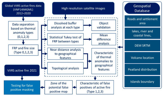
Figure 1.
Flowchart of the workflow for mapping the false positives of active fires using VNP14IMGML data.
3. Results
3.1. Characteristic of Thermal Anomalies Other Than Biomass Fire
There were 1,783,623 points of active fire from 2012 to 2020 over the Indonesian region, which consisted of 95% of type-0 for presumed biomass burning, 1.2% (21,893 points) of type-1 categorized as active volcanoes, 1.4% (24,288 points) of type-2 for other static land sources, and 2.5% (45,452 points) of type-3 for offshore detection/detection over water. Table 2 shows the FRP statistics, confidence level class percentage, and mean fire size for each type of thermal anomaly. The Tukey test examining the mean values of FRP for each type of thermal anomaly showed no significant difference between the FRP type-0 and the FRP type-1 at a confidence level of 95%. Meanwhile, there was a significant difference between the mean values of FRP type-1, FRP type-2, and FRP type-3. Most thermal anomalies were predominantly (90%) within the nominal confidence level, with a mean fire size of approximately 0.2 km2.
Table 2.
The statistical values of FRP and the Tukey test results of the mean FRP at each type of thermal anomaly. * The same and different superscript letter in the mean values of FRP represent no significant difference and significant difference, respectively, at the confidence level of 95%. The percentage of the VNP14IMGML were counted for each confidence level (low, high, and nominal) in the period of 2012 to 2020.
Cluster buffer analysis of other thermal anomalies (type-1 to type-3) resulted in 33 cluster buffers of type-1 (active volcanoes) from 21,893 points, 156 cluster buffers of type-2 (other static land sources) from 24,288 points, and 6003 cluster buffers of type-3 (offshore/water detections) from 43,849 points. The spatial distributions of thermal anomalies, other than biomass burning, are shown in Figure 2. The active volcanoes in the green triangle are distributed across Sumatra Island, Java Island, Bali and Nusa Tenggara Islands, North Sulawesi, and Halmahera Island (Figure 2). All the 33 clusters of type-1 were confirmed at 100% of the 33 volcanoes using high-resolution images from ESRI, Google Earth, or PlanetScope. Figure 2 shows the thermal anomaly type-2 (yellow dots) allocated to Sumatra, Kalimantan, Java, Sulawesi, Maluku, and Papua; none of them were found in Bali and Nusa Tenggara Islands. The spatial distribution of the thermal anomaly type-3, represented by red dots, generally followed the major river lines in Kalimantan and Sumatra or the coastal lines in most Indonesian islands. Examples of the enlarged image of the distribution of thermal anomaly type-3 were shown over East Kalimantan and West Nusa Tenggara Island.
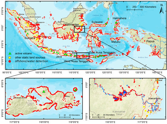
Figure 2.
The spatial distribution of VNP14IMGML for thermal anomalies other than biomass burning in Indonesia and examples of its enlargement areas over West Nusa Tenggara Island and East Kalimantan. They are type-1 for active volcanoes (green triangle), type-2 for other static land sources (yellow dot), and type-3 for offshore detection/detection over water (red dot). The data period is 2012–2020.
Validation of the random sampling points of thermal anomaly type-2 using high-resolution images revealed six dominant objects for type-2 (Figure 3a). The greatest extent of type-2 data was found in the industrial and mining area (5107 points or 43%), then industrial rooftops area (2926 points or 24%), open mining areas (2100 points or 17%), gas flare areas (1641 points or 14%), agricultural areas with mulch (154 points or 1%,) and industrial areas with chimneys (40 points or 0.3%). Most thermal anomalies over gas flare stations exist in Sumatra with less in Kalimantan and Sulawesi. Thermal anomalies over open mining areas were found in Kalimantan, Sumatra, Java, and Maluku. False alarms from industrial building rooftops were distributed on most of the big islands of Indonesia, that is, Java, Sumatra, Kalimantan, Sulawesi, and Papua. The industrial mining area, which is classified as a false alarm, was usually found to be an industrial building with a large open mining area that was predominantly located on the big islands of Indonesia. For the other thermal anomaly, type-3, we selected the cluster buffers based on stratified random sampling for 500 clusters over the Indonesian region to be validated with high-resolution images. We found that most type-3 (73%) occurred on open land in the surrounding coastal area and water bodies (rivers and lakes). Other false detections of type-3 (approximately 24%) occurred over offshore, water bodies, and coastal areas. The minor objects (2%) included mining areas, roads, bright rooftops, volcanoes, and gas flares.

Figure 3.
(a) The allocation of dominated objects in thermal anomaly type-2 and thermal anomaly of type-3 over Indonesian region were analyzed using high-resolution images; (b) the percentage of number of type-2 and type-3 data on peatland and non-peatland in Kalimantan, Sumatra, and Papua.
Figure 3b shows that most type-2 and type-3 data were in non-peatland. The type-2 data were approximately 99% (Kalimantan), 64% (Sumatra), and 87% (Papua) in non-peatland, while the type-3 data were 81% (Kalimantan), 67% (Sumatra), and 82% (Papua) in non-peatland.
Near-distance analysis was used to examine the characteristics of other thermal anomaly distributions based on geographical features (Figure 4). Figure 4a shows the near distance of thermal anomaly type-1 to the GIS volcano points, which are predominantly located close to the volcano points at approximately 446 m (mean) and 371 m (median). From the histogram in Figure 4b,c, type-2 data were not associated with the position of water bodies and coastal lines. Most type-2 were found far away from water bodies and coastlines, with a median distance of approximately 5 km and 34 km, respectively. However, we found that type-2 was associated with settlement areas (Figure 4d) and road lines (Figure 4e), with median distances of approximately 642 m and 112 m, respectively. Figure 4f shows that the type-3 data are associated with water bodies and coastline positions at a distance of 366 m (median value). Topographically from DEM-SRTM, type-1 data as the thermal anomaly in active volcanoes are associated with high terrain, approximately 1942 m above sea level (Figure 4g). Meanwhile, type-2 data randomly exist in low landscapes of less than 100 m and higher terrain of less than 700 m (Figure 4h). The type-3 data are predominantly located on the lowlands within 104 m above sea level (Figure 4i).
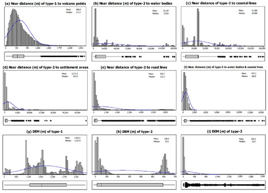
Figure 4.
The histogram of estimated near-distance values (m) from the points location of type-1, type-2, and type-3 VNP14IMGML to the geographical features (a–i) and the histogram of extracted DEM-SRTM values on type-1, type-2, and type-3 VNP14IMGML (g–i).
Some examples of other thermal anomalies of biomass burning from VNP14IMGML data (type-1, type-2, and type-3) overlaid on high-spatial-resolution images are shown in Figure 5. Most thermal anomalies are permanent hot objects such as active volcanoes, industrial areas with bright rooftops and chimneys, open mining areas, and industrial gas flares. Meanwhile, false detection over water or offshore and open land close to the coastal zones might depend on the variance of local surface temperature and the effect of sun-glint. However, the detection of these objects can be categorized as false positives for biomass burning because there is no vegetated area over these objects.
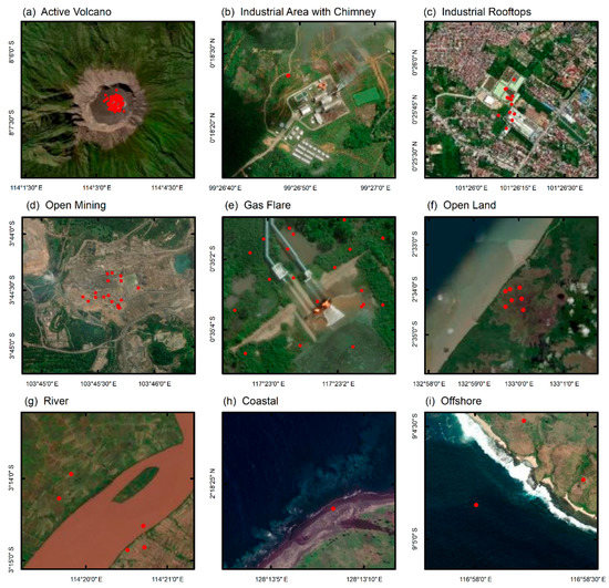
Figure 5.
Examples of false-positive objects for biomass fire. The VNP14IMGML type 1 to type 3 period of 2018–2020 was overlaid on high-spatial-resolution images. The red dots represents the points of false-positive active fires.
3.2. Zone Map of False-Positive Active Fires for Biomass Burning
Table 3 shows a detailed analysis of near distance between the locations of thermal anomalies (type-1, type-2, type-3) and permanent geo-features (volcanoes, roads, settlements, water bodies, and coastlines) based on eight regional islands. Type-1 data were found in six regional islands (Sumatra, Sulawesi, Maluku, Java, Bali and West Nusa Tenggara, and East Nusa Tenggara), which is predominantly located in a distance of 233 m to 411 m from the volcano point. There are no type-1 data in Kalimantan and Papua because there are no volcanoes on those islands. We found the type-2 data existed on six regional islands, except on the islands of Bali and Nusa Tenggara. The near distance of type-2 to road and settlement areas is highly significant on Java Island. Other type-2 data which were located in Kalimantan, Sumatra, Sulawesi, and Papua existed adjacent to roads, except in Maluku. In Maluku, we also found that the type-2 data are far (9815 m) from settlement areas. The location of type-2 data in Sumatra and Kalimantan are also found quite far from settlement areas (2233 m and 3436 m). Meanwhile, the near distance of type-3 data to the water bodies and coastlines are approximately 194 m to 463 m.
Table 3.
Near distance between thermal anomaly (type-1, type-2, type-3) locations and permanent geo-features based on island regions. The unit of median values of near distance is in meters. # is the total number of data.
Following the results shown in Table 3, a detailed analysis was performed to investigate the type-2 data in Kalimantan and Sumatra related to the settlement areas, and the type 2 data in Maluku related to roads and settlements. Figure 6a shows the histogram distribution of near distance of type-2 to settlement areas in Kalimantan and Sumatra, showing that the highest frequency of type-2 data is allocated adjacent to settlement areas; however, the data also spread to various distances following the existing settlement features. Figure 6a also shows that there are two histogram regions (c and d) of the near distance of type-2 data to the road and settlement areas in Maluku. The first histogram (c) shown that the nearest settlement area is approximately 2000 m from type-2 data, while the second histogram (d) is approximately 10,000 m of distance. This situation may refer to there being no existing settlement features from the GIS data near type-2 data. Meanwhile, the first histogram (c) shows a significant allocation of type-2 data to road lines in Maluku, but the second histogram (d) shows there are no existing road features near type-2 data. In the spatial image of type-2 data in Maluku, shown in Figure 6b, both c and d regions are located in the coastal region. Figure 6c represents the spatial image of the histogram of near distance of type-2 in the c region which shows high significance with the road features (white lines), whereas in Figure 6d, there are no GIS geo-feature data shown in the area. This is the limitation of GIS data for representing updated geo-features.

Figure 6.
(a) The histogram distribution for near-distance analysis between type-2 data to the settlement areas in Kalimantan, Sumatra, and Maluku, and near distance of type-2 to the roads in Maluku; (b) the spatial location for type-2 data in Maluku overlaid on high spatial images from Google Earth; (c) enlarged image for the first hotspot cluster (red dots) situated in industrial mining area with GIS road features (white lines); (d) enlarged image for the second hotspot cluster (red dots) in industrial mining area; no road features. Both hotspot clusters located in coastal areas.
Based on the results of the median values of the near distance of type-1, type-2, and type-3 data to the geo-features in each island regions, we created a zone map of the potential false positives for biomass burning over the Indonesian area (Figure 7). We used the buffer distance values from the geo-features listed in Table 3, except for the distance of settlement areas in Kalimantan and Sumatra using the first quantile values, that is 0 m (Kalimantan) and 78 m (Sumatra). For Maluku, we omitted the type-2 distances to road and settlement areas in Maluku and used the distance of type-3 to water bodies and coastlines. Figure 7 shows that most false-positive active fires for biomass burning exist on Java Island. Java Island is the most-populated island in Indonesia, with less biomass than other islands, such as Sumatra, Kalimantan, Sulawesi, and Papua.
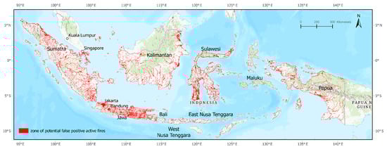
Figure 7.
Zone map of potential false-positive active fires for biomass burning from low-spatial-resolution data.
We applied the zone map mentioned above to eliminate false positives from the VIIRS active fire data for 2021. In 2021, there were 54,411 VIIRS active fires over the Indonesian region. After implementing the zone map, the remaining VIIRS active fires were 47,272 (87%), while the false-positive active fires were approximately 7139 (13%). Figure 8 shows that the false-positive active fires in 2021 were relatively below the average of false-positive active fire in the period of 2012 to 2020.
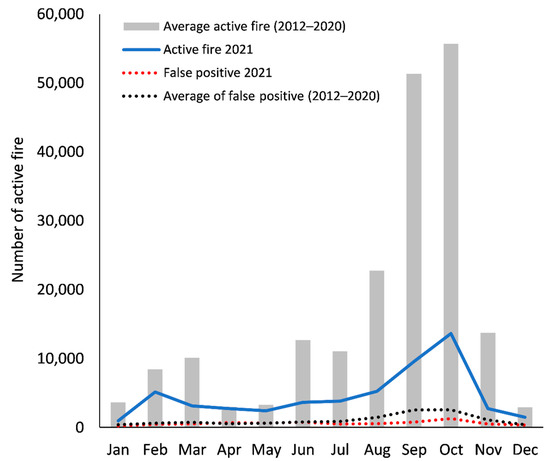
Figure 8.
The monthly VIIRS active fires in Indonesia with the false-positive active fires extracted from the zone map of false active fires in year of 2021 and in the period of 2012 to 2020.
We validated the selected positives active fires at approximately 30% (2142 points) of the false-positive data which was randomly distributed in the Indonesian region. The validation was performed using high spatial images (PlanetScope and Google Earth images) to confirm the actual objects on the selected points. We found the True of false-positive data in 2074 points while 68 points corresponded to actual fires which were confirmed by smoke features emanating from the ground in PlanetScope images. In this case, the user accuracy of false-positive active fires in 2021 classified by the zone map of potential false-positive active fire was 97%.
4. Discussion
In this study, the characteristics of false-positive fires were explored using FRP values, level of confidence, fire pixel area, and their allocations to permanent geographical features. Based on the FRP values, we found a significant difference in mean values among the thermal anomaly type-1 (active volcanoes), type-2 (other static land sources), and type-3 (offshore and water sources) at a confidence level of 95%. The thermal anomaly type-1 group were not statistically different from the thermal anomaly type-0 group (biomass burning). However, we found that the maximum FRP for thermal anomaly type-1 (528 MW) was lower than that of the FRP for thermal anomaly type-0 (991 MW). The mean FRP of thermal anomaly type-1 and type-0 was approximately 8.6 MW and 8.8 MW, respectively. Meanwhile the FRP for thermal anomaly type-2 and type-3 was approximately 5.8 MW and 7.1 MW, respectively. The use of VIIRS FRP for monitoring volcanic eruptions and detecting industrial heat sources was also reported by [49,50,51,52]. The minimum FRP detected for other thermal anomalies was 0.1 MW, similar to [36], which stated that VIIRS could detect low thermal anomalies less than 0.5 MW. Moreover, we found that more than 90% of the thermal anomaly types of VIIRS active fires, including biomass burning, were at the nominal confidence level for active fires. The active fires with high and low confidence levels were less than 10%. The fire pixel areas were predominantly between 0.21 km2. These physical properties of active fires in Indonesia are most likely depicted by Indonesia’s weather and environment and the traditional activities of local farmers practicing small burning for planting preparations. Typical weather with low wind speed, humid atmosphere, and the typical landscape of peatland and rainforest as the habitat of Indonesian fires may influence the nature of Indonesian fires.
The validations for thermal anomaly type-1 were assessed and found to be 100% linked to active volcanoes. There are no type-1 data in Kalimantan and Papua. Although there are 127 volcanoes in Indonesia [37], only 33 were detected by VIIRS active fires from 2012 to 2020. Meanwhile, thermal anomaly type-2 is mainly situated in the big islands of Indonesia (Kalimantan, Sumatra, Sulawesi, Java, and Papua). We found no type-2 data in Bali and Nusa Tenggara Islands. The type-2 data consisted of six dominant objects identified by high-resolution images: i.e., industrial and mining areas, industrial rooftops, open mining areas, gas flares, agriculture with mulch, and industrial areas with chimneys. In previous studies, these features were also found to be false positives in VIIRS active fires [1,9]. Thermal anomaly type-2 was associated with settlement areas and roads within less than 1 km. We found no association between thermal anomaly type-2 and water bodies or coastal areas. In contrast to type-2, thermal anomaly type-3 is strongly associated with the coastal lines and the water body areas. From the high-resolution images, we found that the predominant object along the coastlines and water bodies categorized as thermal anomaly type-3 was open land, such as a riverbed. In tropical peatlands, smoldering fires are present in recently burnt areas and open land. However, further investigation is needed to confirm whether smoke is present on the soil surface, to verify if the peatland itself is actually smoldering.
Moreover, we found that thermal anomaly type-3 occurred in water (i.e., lakes and rivers) and offshore. Referring to the attribute of type-3 in the VNP14IMGML data alone, as an offshore detection or detection over water, the accuracy of thermal anomaly type-3 was only 25% on offshore/water detection. Other type-3 detections were found on open land in coastal areas or surrounding water bodies. However, all these objects are false-positive objects for biomass burning because there is no biomass in those areas.
The outliers shown in the histograms of the near distance between the geographical features and the points of thermal anomalies were due to the missing geographical features mapped by the GIS map, for example, industrial buildings in the plantation area far from the settlement areas or road lines. In this case, the near-distance analysis was estimated from the available features that were not close to the thermal anomaly points. The updated GIS map can improve the performance of the zone map to remove the false-positive active fires. Moreover, the false-positive active fire detection can be integrated into assessments of multi-sensor optic and SAR analysis [53,54].
The likelihood of a false-positive active fire on a populated island (e.g., Java) is higher than that on other islands. The false positives in populated areas are mainly sourced from bright rooftop buildings from industrial areas or settlements. In addition, false positives are often observed in open-pit mining areas. Open-pit mining is a surface mining technique that extracts minerals from an open pit relatively close to the earth’s surface. Most of Indonesia’s open-mining materials are mineral fuels, including coal, natural gas, tin, nickel, copper, and gold. These mining areas are predominantly surrounded by vegetated areas, resulting in thermal anomalies. The coal mining areas may also result in a thermal anomaly from smoldering coal. An industrial gas flare alone is categorized as a fire by the VIIRS active fire algorithm. However, a gas flare is a permanent fire that needs to be removed from the VIIRS active fire information for biomass fire monitoring. The thermal anomaly over mining areas was found in most of the islands in Indonesia, such as Sumatra, Kalimantan, Sulawesi, Papua, Java, Maluku, and Nusa Tenggara, which coincides with the zone map of energy and mineral geospatial data from the Ministry of Energy and Mineral Resources, Republic of Indonesia [55].
The implementation of the zone map for removing false-positive active fires from VIIRS active fires was applied to the 2021 active fire data. The zone map has reduced 13% of the active fire data, representing the potential false-positive data for biomass burning. The user accuracy of the zone map in mapping the false-positive active fire was 97%. Some of the true fires were found over peatlands surrounding the rivers in Sumatra and Kalimantan. However, removing false positives from active fire information can provide a better strategy for firefighters to prioritize the ground validation activities of biomass burning.
5. Conclusions
The characteristics of false-positive active fire for biomass burning were explored from Indonesia’s VIIRS active fire data from 2012 to 2020. The FRP of thermal anomalies other than biomass burning are statistically different at the 95% confidence level. Most other thermal anomalies of VIIRS active fire (>90%) were found at the nominal confidence level with a mean fire size of 0.21 km2. False-positive active fires from 2012 to 2020 were found in 33 active volcanoes (type-1), and the majority of other thermal anomalies on the static land source (type-2) consisted of six dominant objects, that is, industrial and mining areas, industrial rooftops, open mining areas, gas flares, agricultural areas, and industrial areas with chimneys. Type-3 thermal anomaly data were mainly found on open land adjacent to coastal lines and water bodies, with fewer over water bodies and offshore. Each of the other thermal anomaly types of the VIIRS active fire were confirmed by high spatial images as false positives for biomass burning. The zone map of false-positive active fires for low-spatial-resolution data was established in this study by considering the allocations of thermal anomalies other than biomass burning to the permanent geographical features. Implementing the zone map of false-positive active fire to the 2021 active fire data has removed approximately 13% of the data as the false positives of biomass burning. This zone map provided an accuracy of 97% which could support efficient ground validation for firefighters to monitor forest/land fire in the field. Further improvement of the zone map could be accomplished by implementing an updated GIS map and an adjustment of the zone map in peatland areas near rivers to consider peatland fires. In future studies, false-positive active fires over open land can be explored to minimize false detection of active fires in tropical regions.
Author Contributions
Parwati Sofan, Fajar Yulianto, Anjar Dimara Sakti conceived and designed the experiments; Parwati Sofan performed the experiments; Parwati Sofan, Fajar Yulianto, Anjar Dimara Sakti analyzed the data; Parwati Sofan pre-processed the base datasets; Parwati Sofan, Fajar Yulianto, Anjar Dimara Sakti wrote the paper. All authors have read and agreed to the published version of the manuscript.
Funding
This research was funded by Capacity Building Research Program for ITB Young Scientists by the Institute of Research and Community Service Institut Teknologi Bandung.
Institutional Review Board Statement
Not applicable.
Informed Consent Statement
Not applicable.
Data Availability Statement
The datasets generated during and/or analyzed during the current study are available from the corresponding author on reasonable request.
Acknowledgments
The authors would like to thank to the University of Maryland for the VNP14IMGML data access. We are grateful to acknowledge the support from National Research and Innovation Agency of Indonesia and Institut Teknologi Bandung. We also thank the anonymous reviewers whose critical and constructive comments greatly helped us to prepare an improved and clearer version of this paper. All persons and institutes who kindly made their data available for this research are acknowledged.
Conflicts of Interest
The authors declare no conflict of interest.
References
- Coskuner, K.A. Assessing the performance of MODIS and VIIRS active fire products in the monitoring of wildfires: A case study in Turkey. IForest (Viterbo) 2022, 15, 85–94. [Google Scholar] [CrossRef]
- Davies, D.; Ederer, G.; Olsina, O.; Wong, M.; Cechini, M.; Boller, R. NASAs Fire Information for Resource Management System (FIRMS): Near Real-Time Global Fire Monitoring Using Data from MODIS and VIIRS; Goddard Space Flight Center, Goddard Space Flight Center: Greenbelt, MD, USA, 2019.
- Fu, Y.; Li, R.; Wang, X.; Bergeron, Y.; Valeria, O.; Chavardès, R.D.; Wang, Y.; Hu, J. Fire Detection and Fire Radiative Power in Forests and Low-Biomass Lands in Northeast Asia: MODIS versus VIIRS Fire Products. Remote Sens. 2020, 12, 2870. [Google Scholar] [CrossRef]
- Giglio, L.; Schroeder, W.; Justice, C.O. The collection 6 MODIS active fire detection algorithm and fire products. Remote Sens. Environ. 2016, 178, 31–41. [Google Scholar] [CrossRef] [PubMed]
- Oliva, P.; Schroeder, W. Assessment of VIIRS 375 m active fire detection product for direct burned area mapping. Remote Sens. Environ. 2015, 160, 144–155. [Google Scholar] [CrossRef]
- Schroeder, W.; Giglio, L. Visible Infrared Imaging Radiometer Suite (VIIRS) 750 m Active Fire Detection and Characterization Algorithm Theoretical Basis Document; University of Maryland: Washington, DC, USA, 2016. [Google Scholar]
- Sofan, P.; Bruce, D.; Schroeder, W.; Jones, E.; Marsden, J. Assessment of VIIRS 375 m active fire using tropical peatland combustion algorithm applied to Landsat-8 over Indonesia’s peatlands. Int. J. Digit. Earth 2020, 13, 1695–1716. [Google Scholar] [CrossRef]
- Li, P.; Xiao, C.; Feng, Z.; Li, W.; Zhang, X. Occurrence frequencies and regional variations in Visible Infrared Imaging Radiometer Suite (VIIRS) global active fires. Glob. Chang. Biol. 2020, 26, 2970–2987. [Google Scholar] [CrossRef]
- Nadarajan, A.S.S.R.; Santhosh, A.; Ramesh, R. Analysis of Forest Fire in Australia using Visible Infrared Imaging Radiometer Suite. In Proceedings of the 2021 11th International Conference on Cloud Computing, Data Science & Engineering (Confluence), Noida, India, 28–29 January 2021; pp. 482–486. [Google Scholar]
- Dozier, J. A method for satellite identification of surface temperature fields of subpixel resolution. Remote Sens. Environ. 1981, 11, 221–229. [Google Scholar] [CrossRef]
- Justice, C.O.; Giglio, L.; Korontzi, S.; Owens, J.; Morisette, J.T.; Roy, D.; Descloitres, J.; Alleaume, S.; Petitcolin, F.; Kaufman, Y. The MODIS fire products. Remote Sens. Environ. 2002, 83, 244–262. [Google Scholar] [CrossRef]
- Giglio, L.; Descloitres, J.; Justice, C.O.; Kaufman, Y.J. An enhanced contextual fire detection algorithm for MODIS. Remote Sens Environ. 2003, 87, 273–282. [Google Scholar] [CrossRef]
- Sakti, A.D.; Anggraini, T.S.; Ihsan, K.T.; Misra, P.; Trang, N.T.; Pradhan, B.; Wenten, I.G.; Hadi, P.O.; Wikantika, K. Multi-air pollution risk assessment in Southeast Asia region using integrated remote sensing and socio-economic data products. Sci. Total Environ. 2022, 854, 2023. [Google Scholar] [CrossRef]
- Chroeder, W.; Oliva, P.; Giglio, L.; Csiszar, I.A. The New VIIRS 375 m active fire detection data product: Algorithm description and initial assessment. Remote Sens. Environ. 2014, 143, 85–96. [Google Scholar] [CrossRef]
- Xu, W.; Wooster, M.J.; Roberts, G.; Freeborn, P. New GOES imager algorithms for cloud and active fire detection and fire radiative power assessment across North, South and Central America. Remote Sens. Environ. 2010, 114, 1876–1895. [Google Scholar] [CrossRef]
- Wooster, M.J.; Xu, W.; Nightingale, T. Sentinel-3 SLSTR active fire detection and FRP product: Pre-launch algorithm development and performance evaluation using MODIS and ASTER datasets. Remote Sens. Environ. 2012, 120, 236–254. [Google Scholar] [CrossRef]
- Wickramasinghe, C.H.; Jones, S.; Reinke, K.; Wallace, L. Development of a multi-spatial resolution approach to the surveillance of active fire lines using Himawari-8. Remote Sens. 2016, 8, 932. [Google Scholar] [CrossRef]
- Wooster, M.J.; Roberts, G.J.; Giglio, L.; Roy, D.P.; Freeborn, P.H.; Boschetti, L.; Justice, C.; Ichoku, C.; Schroeder, W.; Davies, D.; et al. Satellite remote sensing of active fires: History and current status, applications and future requirements. Remote Sens. Environ. 2021, 267, 112694. [Google Scholar] [CrossRef]
- Sofan, P.; Bruce, D.; Jones, E.; Marsden, J. Detection and validation of tropical Peatland flaming and smouldering using Landsat-8 SWIR and TIRS bands. Remote Sens. 2019, 11, 465. [Google Scholar] [CrossRef]
- Tanpipat, V.; Honda, K.; Nuchaiya, P. Modis hotspot validation over Thailand. Remote Sens. 2009, 1, 1043–1054. [Google Scholar] [CrossRef]
- Filizzola, C.; Corrado, R.; Marchese, F.; Mazzeo, G.; Paciello, R.; Pergola, N.; Tramutoli, V. RST-FIRES, an exportable algorithm for early-fire detection and monitoring: Description, implementation, and field validation in the case of the MSG-SEVIRI sensor. Remote Sens Environ. 2016, 186, 196–216. [Google Scholar] [CrossRef]
- Sakti, A.D.; Fauzi, A.I.; Takeuchi, W.; Pradhan, B.; Yarime, M.; Vega-Garcia, C.; Agustina, E.; Wibisono, D.; Anggraini, T.S.; Theodora, M.O.; et al. Spatial Prioritization for Wildfire Mitigation by Integrating Heterogeneous Spatial Data: A New Multi-Dimensional Approach for Tropical Rainforests. Remote Sens. 2022, 14, 543. [Google Scholar] [CrossRef]
- Mitchell, S.; Jones, S.; Reinke, K.; Lorenz, E.; Reulke, R. Assessing the utility of the TET-1 hotspot detection and characterization algorithm for determining wildfire size and temperature. Int. J. Remote Sens. 2016, 37, 4731–4747. [Google Scholar] [CrossRef]
- Ichoku, C.; Giglio, L.; Wooster, M.J.; Remer, L.A. Global characterization of biomass-burning patterns using satellite measurements of fire radiative energy. Remote Sens. Environ. 2008, 112, 2950–2962. [Google Scholar] [CrossRef]
- Calle, A.; Salvador, P. The active fire FRP estimation: Study on sentinel-3/SLSTR. IEEE Geosci. Remote Sens. Lett. 2013, 10, 1046–1049. [Google Scholar] [CrossRef]
- Sifakis, N.I.; Iossifidis, C.; Kontoes, C.; Keramitsoglou, I. Wildfire detection and tracking over Greece using MSG-SEVIRI satellite data. Remote Sens. 2011, 3, 524–538. [Google Scholar] [CrossRef]
- Wooster, M.J.; Zhukov, B.; Oertel, D. Fire radiative energy for quantitative study of biomass burning: Derivation from the BIRD experimental satellite and comparison to MODIS fire products. Remote Sens. Environ. 2003, 86, 83–107. [Google Scholar] [CrossRef]
- Siegert, F.; Zhukov, B.; Oertel, D.; Limin, S.; Page, S.E.; Rieley, J.O. Peat fires detected by the BIRD satellite. Int. J. Remote Sens. 2004, 25, 3221–3230. [Google Scholar] [CrossRef]
- Smith, A.M.S.; Wooster, M.J. Remote classification of head and backfire types from MODIS fire radiative power and smoke plume observations. Int. J. Ofwildl. Fire 2005, 14, 249–254. [Google Scholar] [CrossRef]
- Schroeder, W.; Giglio, L. NASA VIIRS Land Science Investigator Processing System (SIPS) Visible Infrared Imaging Radiometer Suite (VIIRS) 375 m & 750 m Active Fire Products: Product User’s Guide Version 1.4. Nasa; NASA: Washington, DC, USA, 2018.
- Li, F.; Zhang, X.; Kondragunta, S.; Csiszar, I. Comparison of Fire Radiative Power Estimates From VIIRS and MODIS Observations. J. Geophys. Res. Atmos. 2018, 123, 4545–4563. [Google Scholar] [CrossRef]
- Zhukov, B.; Lorenz, E.; Oertel, D.; Wooster, M.; Roberts, G. Spaceborne detection and characterization of fires during the bi-spectral infrared detection (BIRD) experimental small satellite mission (2001–2004). Remote Sens. Environ. 2006, 100, 29–51. [Google Scholar] [CrossRef]
- Goldammer, J.G. Forest on Fire. Sci. Compass-Rev. 1999, 286, 2098–2102. [Google Scholar] [CrossRef]
- Hoscilo, A.; Page, S.E.; Tansey, K.J.; Rieley, J.O. Effect of repeated fires on land-cover change on peatland in southern Central Kalimantan, Indonesia, from 1973 to 2005. Int. J. Wildl. Fire 2011, 20, 578–588. [Google Scholar] [CrossRef]
- Sakti, A.D.; Tsuyuki, S. Spectral Mixture Analysis of Peatland Imagery for Land Cover Study of Highly Degraded Peatland in Indonesia. In International Archives of the Photogrammetry, Remote Sensing and Spatial Information Science; Copernicus Publications: Göttingen, Germany, 2015; Volume XL-7/W3. [Google Scholar]
- Zhang, T.; Wooster, M.J.; Xu, W. Approaches for synergistically exploiting VIIRS I- and M-Band data in regional active fire detection and FRP assessment: A demonstration with respect to agricultural residue burning in Eastern China. Remote Sens. Environ. 2017, 198, 407–424. [Google Scholar] [CrossRef]
- MAGMA Indonesia. Volcano Types in Indonesia. PVMBG, Pusat Vulkanologi dan Mitigasi Bencana Geologi (the Centre of Vulcanology and Geological Hazard Mitigation of Indonesia). 2021. Available online: https://magma.vsi.esdm.go.id (accessed on 26 July 2022).
- Hogg, R.V.; Craig, A.T. Introduction to Mathematical Statistic; Prentice Hall PTR: Englewood Cliffs, NJ, USA, 1994. [Google Scholar]
- Ott, L. An Introduction to Statistical Methods and Data Analysis, 4th ed.; California’ Duxbury Press: Belmont, CA, USA, 1992; p. 1051. [Google Scholar]
- ESRI. Near (Analysis). Available online: https://pro.arcgis.com/en/pro-app/2.8/tool-reference/analysis/near.htm (accessed on 26 July 2022).
- Osaki, M.; Tsuji, N. Tropical Peatland Ecosystems; Springer: Berlin/Heidelberg, Germany, 2015. [Google Scholar] [CrossRef]
- Osaki, M.; Nursyamsi, D.; Noor, M.; Wahyunto; Segah, H. Peatland in Indonesia. In Tropical Peatland Ecosystems; Springer: Tokyo, Japan, 2016; pp. 49–58. [Google Scholar] [CrossRef]
- Congalton, R.G. A review of assessing the accuracy of classifications of remotely sensed data. Remote Sens. Environ. 1991, 37, 35–46. [Google Scholar] [CrossRef]
- Congalton, R.G. Accuracy assessment and validation of remotely sensed and other spatial information. Int. J. Wildl. Fire 2001, 10, 321–328. [Google Scholar] [CrossRef]
- Congalton, R.G.; Green, K. Assessing the Accuracy of Remotely Sensed Data: Principles and Practices; CRC Press: Boca Raton, FL, USA, 2019. [Google Scholar]
- Sari, I.L.; Weston, C.J.; Newnham, G.J.; Volkova, L. Assessing Accuracy of Land Cover Change Maps Derived from Automated Digital Processing and Visual Interpretation in Tropical Forests in Indonesia. Remote Sens. 2021, 13, 1446. [Google Scholar] [CrossRef]
- Tran, B.N.; Tanase, M.A.; Bennett, L.T.; Aponte, C. Evaluation of spectral indices for assessing fire severity in Australian temperate forests. Remote Sens. 2018, 10, 1680. [Google Scholar] [CrossRef]
- Olofsson, P.; Foody, G.M.; Herold, M.; Stehman, S.V.; Woodcock, C.E.; Wulder, M.A. Good practices for estimating area and assessing accuracy of land change. Remote Sens. Environ. 2014, 148, 42–57. [Google Scholar] [CrossRef]
- Fisher, D.; Wooster, M.J. Shortwave IR Adaption of the Mid-Infrared Radiance Method of Fire Radiative Power (FRP) Retrieval for Assessing Industrial Gas Flaring Output. Remote Sens. 2018, 10, 305. [Google Scholar] [CrossRef]
- Li, R.; Tao, M.; Zhang, M.; Chen, L.; Wang, L.; Wang, Y.; He, X.; Wei, L.; Mei, X.; Wang, J. Application Potential of Satellite Thermal Anomaly Products in Updating Industrial Emission Inventory of China. Geophys. Res. Lett. 2021, 48. [Google Scholar] [CrossRef]
- Kong, X.; Wang, X.; Jia, M.; Li, Q. Estimating the Carbon Emissions of Remotely Sensed Energy-Intensive Industries Using VIIRS Thermal Anomaly-Derived Industrial Heat Sources and Auxiliary Data. Remote Sens. 2022, 14, 2901. [Google Scholar] [CrossRef]
- Campus, A.; Laiolo, M.; Massimetti, F.; Coppola, D. The Transition from MODIS to VIIRS for Global Volcano Thermal Monitoring. Sensors 2022, 22, 1713. [Google Scholar] [CrossRef]
- De Luca, G.; Silva, J.M.N.; Modica, G. Short-term temporal and spatial analysis for post-fire vegetation regrowth characterization and mapping in a Mediterranean ecosystem using optical and SAR image time-series. Geocarto Int. 2022. [Google Scholar] [CrossRef]
- De Luca, G.; Silva, J.M.N.; Modica, G. A workflow based on Sentinel-1 SAR data and open-source algorithms for unsupervised burned area detection in Mediterranean ecosystems. GIScience Remote Sens. 2021, 58, 516–541. [Google Scholar] [CrossRef]
- Setyowati, H.A.; Dwinugroho, M.P.; Novelya, N.M.; Wisnuwardhani, E. ESDM One Map Indonesia : Exploring The Energy and Mineral Resources. In Proceedings of the Asian Conference on Remote Sensing, Kuala Lumpur, Malaysia, 15–19 October 2018. [Google Scholar]
Publisher’s Note: MDPI stays neutral with regard to jurisdictional claims in published maps and institutional affiliations. |
© 2022 by the authors. Licensee MDPI, Basel, Switzerland. This article is an open access article distributed under the terms and conditions of the Creative Commons Attribution (CC BY) license (https://creativecommons.org/licenses/by/4.0/).