Abstract
Consistent and optimized territorial planning, imply the use of numerous variables aimed at improving life quality and reduction of environmental impacts. The resilience of the territory to climate change threats is strongly linked to its progressive transformation. This fact is extremely evident in coastal systems, which are intrinsically fragile systems due to their high environmental value and strong anthropogenic pressure. The existing tools and techniques provide to outline future transformation effects through the scenarios analysis. This work has the objective to evaluate the effects of land use changes in the territory of the Abruzzo coast. The conversion from natural soils to artificial uses has a significant impact on several ecosystem services. The regulation services considered in this work are flood regulation, carbon storage and sequestration, and habitat for biodiversity. The first is directly connected to soil sealing which determines a reduction of water infiltration with the consequent overloading of the existing sewerage systems. The quantitative evaluation is made using the concept of surface runoff coefficient. Instead, the estimation of the last two ecosystem services has been made using InVEST (Integrated Valuation of Ecosystem Services and Tradeoffs) models, specifically the Carbon Storage and Sequestration model and the Habitat Quality model. The results show that Land Use Changes (2012–2018) caused a potential increase of 10% in runoff and an annual Carbon Sequestration loss estimated at about €820,000.
1. Introduction
Coastal areas are extremely complex and fragile systems. If one hand these areas have a high level of environmental value [1] on the other, they are subjected to strong anthropogenic pressures linked specifically to the high population density and exacerbated by climate change. The resilience of the territories to climate change threats is strongly linked to their progressive transformation. This fact is extremely evident in coastal systems, which are intrinsically fragile systems due to their high environmental value and strong anthropogenic pressure [2]. Many scientific studies investigated the high fragility of the Mediterranean regions, characterized, especially along the coast, by intense phenomena of land consumption [3]. Specifically, in Italy, coastal areas have a central role in the regional and national socio-economic framework [4]. At the same time, there are growing fragilities, particularly acute in some areas. For example, in the Abruzzo region, there is an increasing number of flooding events that have characterized many coastal cities of Abruzzo, as witnessed by recent news (Tortoreto in 2021, Pescara in 2022, Ortona in 2022). Land use changes determine the variation in the surface water infiltration capacity [5]. Among all, the conversion from natural to artificial soils, especially soil sealing, causes a reduction in water infiltration and an increase in surface runoff. The consequence is the overloading of the existing sewerage systems [6]. Also because of climate change, meteoric events characterized by anomalous intensities are more and more frequent and for this reason, the analysis of runoff variation linked to land use changes could play a key role in mitigation actions. In the short term through de-sealing interventions, and in the future by intervening both with strategic territorial and urban planning. On the other hand, soil sealing leads to the loss of ecosystem services including carbon sequestration and storage and habitat for biodiversity. Ecosystem services have a positive impact on quality of life, but they suffer daily impoverishment due to the phenomenon of land consumption. In this paper, carbon sequestration and storage and habitat quality for biodiversity have been analyzed. The first is strongly connected to the level of naturality of soils [7,8] and contributes to global climate regulation and plays a key role in climate change mitigation and adaptation strategies [9]. Of all types of land cover, natural and semi-natural soils have the highest potential for carbon sequestration. The worst-case scenario is the transformation of these types of soils into artificial and sealed soils. The knowledge of which landscapes are the richest in carbon would help, for example, local governments in defining effective target incentives for landowners in exchange for forest conservation. Habitat quality, on the other hand, consists of the provision of different types of habitats essential for the life of any species and the maintenance of biodiversity itself and represents one of the main reference values in the assessment of the ecosystem status of soils. This service is considered an index of overall biodiversity. Assessing ecosystem services is necessary to develop spatial planning scenarios and ex-ante evaluation of policies. Furthermore, in this way it is possible to consider the level of well-being of society and provide policymakers with tools to monitor and improve well-being [10]. Decision-makers must equip themselves with cognitive and managerial tools capable of considering in spatial planning tools the ecosystem service and distinguishing the different areas of interest and relevance and knowing the interrelations at different spatial-temporal scales. Decision makers and the population should become more aware of the economic value of ecosystem goods and services, which, once destroyed, are sometimes impossible to restore or often are, but only at very high costs [11]. This work analyzes how land use changes modified the territory of the Abruzzo coast. Specifically, about three different soil ecosystem services: flood regulation, carbon storage and sequestration, and habitat for biodiversity.
2. Study Area
The coast of Abruzzo extends for about 130 km from the municipality of Martinsicuro in the north, to the one of San Salvo in the south.
In this work, the coastal belt of 10 km from the coastline has been considered. This choice allows for carrying out a wider range of assessments on phenomena that, although occurring in areas distant from the shoreline, could have effects on the whole system. The territory considered is composed mainly of an extensive hilly strip with valleys of Val Pescara and Valle del Tordino. In the center-north of the region, there is a narrow coastal plain characterized by intense urbanization.
This area covers about 1260 km2 equal to about 11% of the regional territory. The study involves 63 of the 305 municipalities of the Abruzzo region. Most of them are entirely contained in the 10 km range considered, such as Pescara, Vasto, and Martinsicuro, while others, such as Chieti, Atri, and Lanciano, are only partially in the study area. The Istat data, updated to 2022, shows that in the considered municipalities live just over 700,000 inhabitants (55% of the regional population) with a demographic density of 401 inhab./km2, a value significantly higher than the national (195 inhab./km2) and regional (118 inhab./km2). This fact is already an index of the importance of this area both for the demography and, of course, the economy.
3. Materials and Methods
The study area (Figure 1) was divided into 10 belts of 1 km wide to better spatialize land use changes. The Coastal Zone is the data on land use and land use changes. It is available on the website of Land Copernicus (https://land.copernicus.eu/local/coastal-zones, accessed on 27 August 2022) for two different reference years: 2012 and 2018. This data, on land cover/use (LC/LU) with very high resolution (VHR), is developed for the monitoring and mapping of the complex dynamics of the coastal environment. Specifically, the minimum mapping unit (MMU) is 0.5 hectares and the minimum mapping width (MMW) is 10 m. The classification, at the fourth and fifth levels, includes 71 thematic classes whose definitions are based on the Mapping and Assessment of Ecosystems and their Services (MAES) and CORINE (COoRdination of INformation on Environment) Land Cover specified for the coastal areas.
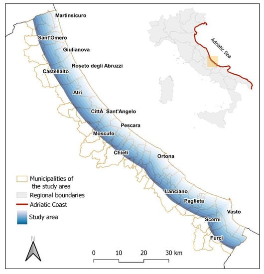
Figure 1.
Study area.
For the estimation of runoff, reference was made to the rational method which is a method to evaluate the water discharge through a specific section of a basin [12]. This empirical method, based on Equation (1), has different conditions to be met for its correct application, especially relating to the calculation of the intensity of rain i. However, this study is outside the scope of the water discharge calculation but focuses on the evaluation of the runoff coefficients.
where:
- Q = water discarge [m3/s];
- i = rain average intensity [m/s];
- A = catchment area [m2];
- φ = runoff coefficient [-]
In this case, it was considered that, with the same intensity of precipitation (i) and area of basin (A), the parameter which varies, depending on the change in land use, is the runoff coefficient φ. The water discharge infiltrated varies proportionally to the degree of waterproofing and, for this reason depending on the variation of the ground cover.
For example, soil with 50% of sealing determines a runoff rate five times higher if compared to natural soil. The runoff coefficient φ (variable from 0 for fully permeable surfaces, to 1 for impermeable surfaces) is the parameter that determines the transformation of rainfall-runoff. This coefficient is equal to the ratio between the volume flown through an assigned section and the meteoric volume. In this study, the evaluation of φ values was made considering the permeability characteristics of the draining basin cover and it comes from scientific literature [13]. As a precaution, the runoff coefficients are considered constant throughout the weather event.
As regards the other two ecosystem services, the evaluation of their variation was carried out using InVEST open-source suite of models for mapping and evaluating ecosystem services provided by soil and seascapes, developed by Stanford University within the “Natural Capital Project” [14]. All spatial analysis is carried out in GIS software (QGIS version 3.16 Hannover).
In this case, the used models are Carbon Storage and Sequestration (CSS) and Habitat Quality (HQ). These ecosystem services were selected based on their importance in the area and their relevance to conservation planning. This model estimates the net amount of carbon stored in the land over time and the market value of the sequestered carbon in the remaining stock. For this evaluation LULC data are required, along with the amount of carbon stored in carbon reserves. LULC input data are the same used for the previous analysis (Coastal Zone). The model, based on the IPCC guidelines [15], requires four typologies of carbon pool: aboveground biomass, belowground biomass, soil, and dead organic matter; these data come from scientific literature [16,17]. The vector data on LULC was converted to raster format with a resolution of 70 × 70 m, this choice is linked to the specification of the Coastal Zone data. The land use classification has been detailed at the third level. In this study, the hypothesis that urbanized soil does not contribute to carbon storage has been made, therefore the associated value is 0. The considered carbon price is equal to 67 $/tC (Carbon exchanged in the ETS market, October 2021—European zone price). Among all types of land cover, natural and semi-natural forests have the highest potential for carbon sequestration, therefore the worst-case scenario is the transformation of natural and semi-natural cover soils into artificialized soils. The output is rasters data showing the amount of carbon stored in tonnes in each pixel for the current and future scenario their difference and the economic value of carbon sequestered.
The Habitat Quality model considers LULC with the hypothesis that portions of land with a higher quality of habitats host a greater richness of native species and that the reduction of the size of a specific habitat and its quality leads to the decline of species [18]. Other input data are the Habitat Suitability and the Threats. The Habitat Suitability parameter indicates the ability to support plant and animal species that contribute to the maintenance and conservation of biodiversity. For this parameter, the values range from 0 (unfavorable habitat) to 1 (favorable habitat). The sensitivity of the habitats to the threats has been analyzed by subdividing the threats into 3 macro-categories based on Coastal Zone classes:
- Urban (111–112–131–132–140);
- Infrastructure (121–122–123–124);
- Agriculture (code 211–212–221–222–231–232–233).
This parameter varies from 0 (threat with low impact on the habitat) to 1 (high impact). The threats considered present different distances of influence, weights (relative impact of each threat on the ecosystem compared to others), and functions of impact decay (linear or exponential). The values used for Habitat Suitability, Threats, and Sensitivity come from scientific literature [19,20,21]. The considered protected areas are Natura 2000 sites (Habitats Directive 92/43/EEC) and EUAP sites, both available on the website of the Geoportale Nazionale (http://www.pcn.minambiente.it/mattm/servizi-di-scaricamento/ accessed on 27 August 2022). The output raster maps are Habitat Quality and Habitat Degradation. The value of Quality and Degradation associated with each cell comes from the existing relationships among adjacent cells, for this reason, the output values are expressed relating to the current conditions. Thus, expressing a range of variation concerning a minimum (0) and a maximum (1). Figure 2 includes a graphical methodology workflow. Appendix A shows all used coefficients and values for the considered variables.
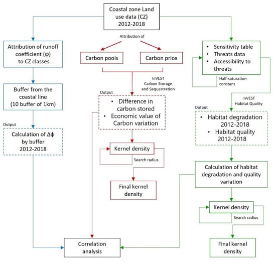
Figure 2.
Flowchart of used analysis methodology.
4. Results
In 2018, in the study area, urban areas amount to about 220 km2, with total coverage of 17%. This value is almost 2.5 times the current national average (7.13% ISPRA, 2022) [22] and 3.5 times higher than the mean value of the Abruzzo Region (5.02% ISPRA, 2022) [22]. The value is significant also if compared to that measured along the Italian Adriatic coast (13.74%). The remaining part of the territory is covered by agricultural uses (68%) and natural and seminatural soils (about 15%). The study area, as said before, was subdivided into 10 buffers of 1 km from the coastline. As you can see in Figure 3, a strong anthropogenic pressure results specifically along the first buffer adjacent to the sea. Specifically, for 2018 the urbanization density (UD) has a maximum of 41% in this buffer, a value higher than that of the Adriatic coast (34.8%). This value halved in the second buffer and progressively decrease towards a 10% value. On the contrary, the agricultural areas show the opposite trend, with a minimum of 38% in the first buffer that increases progressively and tends to the value of about 70%. The regression analysis shows that the anthropogenic pressure decreases sharply from the second kilometer of the shoreline. The conservation of ecological value represents a key point for the quality of life in these places, but the residual ecosystems present in this area are extremely fragmented. Moreover, it is evident how the sea industry extends its main effects (economic activities, tourism, main roads), especially in the first km from the shoreline, as evidenced by the value of urban coverage that already from the second km is halved.
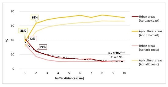
Figure 3.
Percentage trend of the agricultural and urban areas, both for the Abruzzo and Adriatic Coast along the 1 km buffers (2018).
The situation for the Adriatic coast is similar but the reached values are lower. This opposite behavior is the first index of the link between these two soil classes. As reported in Figure 4a, on a total of 500 ha of transformed soils, 40.5% of the total (202.5 ha) is a transformation to urban uses of which, about 130 ha from the transformation of agricultural soils. The remaining transformations have lower entities, and they are mainly internal to the same macro classes. Particular attention was given to the transformation of soil for urban uses. As shown in Figure 4b, between 2012 and 2018 results that the buffers with the greater extent of transformation are the second and the ninth. At 2 km from the coast, about 20% of the total transformation is for urban uses and almost all at the expense of the agricultural areas. A similar situation is detectable at 9 km from the coast with slightly higher values.

Figure 4.
(a) Land use changes between 2012 and 2018; (b) Land use change for urban uses by distances from the coast.
These land use variations inevitably affect ecosystem services. The first to be influenced is flood regulation. From the analysis results that the average runoff coefficient between 2012 and 2018 increased by about 0.1 This means that the surface water runoff of the study area, with the same intensity of precipitation, has increased by 10%. In 2012, the value of the average runoff coefficient was 0.54 which becomes 0.63 in 2018. As shown in the graph in Figure 5, the area in which the increase is greatest is between 6 and 7 km from the shoreline. With an increase of average φ of 0.25, which corresponds to an increase equal to 25% of the flow into the sewerage system. Significant increases were recorded in the 7–9 km range, where the average runoff coefficient increased by 17%.
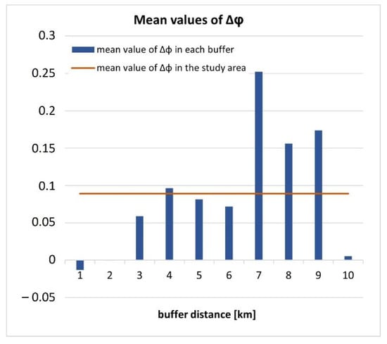
Figure 5.
Variation of the runoff coefficient between 2012 and 2018.
In the buffer of 1 km adjacent to the coastline, the variation of the average runoff coefficient touches the lowest value. Specifically sees a decrease of 0.01, even if a low value indicates the transformation into soil with higher infiltration capacity.
Another important ecosystem service considered in this work is carbon storage and sequestration. The homonymous inVEST model was used for their elaboration.
What emerges is that there has been a general shortfall in carbon sequestration processes, amounting to 13,000 tons of carbon. This lack of sequestration has produced damage for failure to sequestration estimated at €820,000. Always considering the buffers of 1 km, as shown in Figure 6, the only in which the economic variation connected to the storage has been positive is between 9 and 10 km. In this case, an average of 64 kg/ha have been sequestrated for an economic value of €51,000. The highest loss is in the first buffer near the shoreline, in which the sequestration reduction is quantified in 278 kg/ha, corresponding to an economic loss of about €220,000. It should be remembered that the latter are those most affected by the anthropic processes
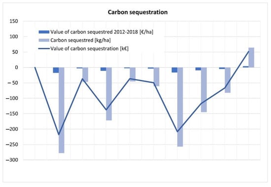
Figure 6.
Carbon sequestration by buffer distance from the coast.
To better understand the areas in which both losses and increases in carbon stock have been concentrated, the kernel density with a radius of influence of 3000 m has been applied. The results are shown in Figure 7. On the left, there are the areas with a higher density of carbon sequestrated (more intense coloring), found in the municipalities of Atri, Sant’Omero, Frisa, Ripa Teatina, and San Giovanni Teatino. On the right, the carbon lost in the analyzed time is observed. Greater losses are found in the municipalities of Roseto, Atri, Pineto, and Scerni.
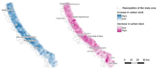
Figure 7.
Kernel density (radius 3 km) of carbon stock related to land use changed between 2012 and 2018.
The last ecosystem service considered in this study is habitat quality for biodiversity. Habitat quality and habitat degradation have been elaborated considering land use covers in 2012 and 2018 (Status layers). Figure 8 and Figure 9 show, respectively, the results related to the reduction and increase of the quality and degradation of the habitat in the analyzed time interval. In the figure also Natura 2000 sites and other protected areas are visible. To evaluate the areas most affected by this variation, also, in this case, the density of kernels with a radius of influence of 3 km has been used. In Figure 8 is possible to catch a correspondence between the areas with the highest kernel density (most intense color) and the protected sites. Significant values of the difference in habitat quality are found homogeneously mainly in the area of the municipalities of Colonnella, Roseto degli Abruzzi, Atri, Spoltore, Francavilla al Mare, Rocca San Giovanni, and San Salvo. In Figure 9 the variation in the degradation of habitat is visible through a kernel density with a 3 km of radius. High-level habitat degradation is detected in the areas of the municipality of Spoltore, Francavilla, and Roseto degli Abruzzi. In these areas, the change in soil cover is such that habitat degradation is changed in a representative way. There are no significant densities in the protected areas; therefore, they are not affected by detectable habitat degradation. Furthermore, to analyze the possible links between the considered Ecosystems Services, we have carried out the correlation analysis through the Pearson coefficient. The results are shown in Table 1. The CSS and HQ are negatively correlated with φ while HQ and CSS show a positive correlation. The increase of φ value, which is related to soil sealing, causes a loss both in HQ and CSS values.
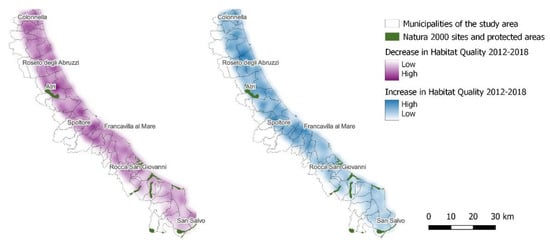
Figure 8.
Habitat quality link to land use changes between 2012 and 2018.
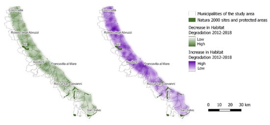
Figure 9.
Habitat degradation linked to land use changes between 2012 and 2018.

Table 1.
Correlation analysis through Pearson coefficient.
5. Discussion
The work has evidenced that in only 6 years and only due to the recorded transitions of land use, there has been an increment of the medium superficial runoff equal to about 10%. However, this value could be higher because of the technical characteristics of the data Coastal zones. It does not allow for the detection of all the dispersed urbanization that, especially in these areas, contributes strongly to increasing soil sealing [23,24,25]. Regarding the analysis of ecosystem services, it should be noted that for the assessment of the ecosystem carbon storage service, the used model follows the IPCC approach. In this method, the carbon sink capacity is a function of land use and cover. This approach allows for rapid evaluation, without requiring too much input data. However, the model has limitations such as:
- simplified carbon cycle,
- static inventory: each hectare is equal to the other,
- carbon sequestration is not counted in areas where there has been no change in land use over time,
- economic evaluation assumes a linear trend in carbon sequestration versus time,
- the detail and quality of the output data depend on the input data of the LULC classes and the accuracy of the values of the carbon pools.
As regards the Habitat Quality model, all landscape threats are additive although there is evidence that, in some cases, the collective impact of multiple threats is greater than the sum of individual threat levels would suggest. Although the study area is well defined, it should be borne in mind that this area is included within a wider landscape and therefore threats to the present habitats also arise from the adjacent area outside it. In this study, however, they have not been taken into consideration ignoring the effect of edge. As a result, the real intensity of the threat on the margins will certainly be greater than estimated.
In this work dealt with the themes of ecosystem services for the Abruzzo Region coastal area. Other works have addressed the topics of ecosystem services of habitat quality, carbon storage, and sequestration for coastal contexts in Europe and worldwide. For example, Lopes, N. D. R. et al. (2022) [26] studied the effects of land use changes and their impact on habitat quality on the northwest coast of Guinea-Bissau. In this case, the land use data come from photointerpretation of satellite images and the estimation of ecosystem services was conducted using InVEST Habitat Quality model. Chung MG et al. (2015) [27] evaluate different ecosystem services such as carbon storage and aesthetic and recreational values of soil, again using InVEST, and show the possible correlations between them. For the Italian and European context, Arcidiacono, et al. (2015) [28] present a possible application methodology for mapping and estimating the qualitative change related to the Habitat Quality function used as a proxy for the evaluation of supporting ecosystem services, in particular biodiversity and conservation. In detail, the ecosystem services were mapped and evaluated within coastal areas also in this case using InVEST models. In this work, however, we have identified a possible correlation not only between ecosystem services and land use changes but also the mutual correlation between them. In addition, the assessment of the ecosystem service of water regulation was carried out through empirical formulas of consolidated use for the design of Italian sewerage systems (Equation (1)). Specifically, with equal rain average intensity, it was possible to estimate the percentage change in flow rates flowing to the network. This variation is linked to the run-off coefficient φ assigned to the specific land use classes according to their permeability.
6. Conclusions
The integrated analyses conducted allowed us to know what land use changes prevailed in the investigated area and then to analyze the direct effects on runoff with the impacts produced in terms of the provision of some ecosystem services. Such knowledge plays a key role in land planning at both the local level (municipalities) and strategic level (catchment or coastal area) [29]. Indeed, the contextual knowledge of land values and ecosystem services delivered, as shown in this study, could then lead to targeting both the type and the location of the transformations by seeking to maximize the gain in ES. In fragile environments, such as precisely coastal areas, such models would be a significant support tool for decision-makers in planning processes. Through a top-down approach, strategic planning would in fact represent the suitable spatial scale for the inclusion of appropriate constraints related to the assessment of ES. In Abruzzo, the current coastal defense plan focuses on actions necessary to maintain/restore the beach without going into the issues involved in safeguarding areas that nevertheless play a role in maintaining the delicate balance of the shoreline. Furthermore, urban transformations affecting the coastal areas are implemented today by each municipal authority within its area of responsibility without an overview or even a prior assessment of the effects in terms of ES and on-shoreline dynamics. From this point of view, the first measure to be taken could be to implement a PTM (Planning Tool Mosaic) aimed at the knowledge of what are the settlement choices of all the territories involved thus allowing to outline of the possible settlement scenario [30,31]. This would be a bottom-up approach in this case, which if adopted could achieve effects on larger spatial scales. As demonstrated in this work, transformations related to soil sealing have produced effects on the run-off and on the water disposal capacity of the sewerage system in some urban areas, as evidenced also by the recent flooding events on the Abruzzo coast. These changes have also affected the dynamics related to the input of sediments to the sea by the hydrographic network. For this reason, the analysis of the effects on the ES examined in this paper due to the implementation of the settlement forecasts contained in the plans of the municipalities involved, could allow the adoption of appropriate safeguard measures to preserve the delicate balance of the entire regional coastal system.
Author Contributions
Conceptualization, Francesco Zullo and Cristina Montaldi; methodology, Francesco Zullo, Cristina Montaldi and Gianni Di Pietro; validation, Francesco Zullo and Cristina Montaldi; formal analysis, Cristina Montaldi and Gianni Di Pietro; investigation, Cristina Montaldi and Gianni Di Pietro; original draft preparation, Cristina Montaldi and Gianni Di Pietro; reviewand editing, Cristina Montaldi and Chiara Cattani; visualization, Cristina Montaldi and Gianni DiPietro. All authors have read and agreed to the published version of the manuscript.
Funding
This research received no external funding.
Institutional Review Board Statement
Not applicable.
Informed Consent Statement
Not applicable.
Data Availability Statement
The data presented in this study are available on request from the corresponding author.
Conflicts of Interest
The authors declare no conflict of interest.
Appendix A
| Values of the Runoff Coefficient | ||
| Code | Description | Runoff Coefficient φ |
| 11110 | Continuous urban fabric (IMD ≥ 80%) | 0.9 |
| 11120 | Dense urban fabric (IMD ≥ 30–80%) | 0.525 |
| 11200 | Industrial, commercial, public and military units | 0.8 |
| 12100 | Road networks and associated land | 0.95 |
| 12200 | Railways and associated land | 0.9 |
| 12300 | Port areas and associated land | 1 |
| 12400 | Airports and associated land | 0.8 |
| 13100 | Mineral extraction | 1 |
| 13200 | Dump sites | 1 |
| 13300 | Construction sites | 0.6 |
| 13400 | Land without current use | 0.7 |
| 14000 | Green urban, sports and leisure facilities | 0.375 |
| 21000 | Arable land (annual crops) | 0.7 |
| 22000 | Permanent crops | 0.6 |
| 22100 | Vineyards, fruit trees and berry plantations | 0.7 |
| 23200 | Complex and mixed cultivation patterns | 0.6 |
| 31000 | Broadleaved forest | 0.2 |
| 32000 | Coniferous forest | 0.2 |
| 33000 | Mixed forest | 0.2 |
| 41000 | Managed grassland | 0.4 |
| 42000 | Natural & semi-natural grassland | 0.4 |
| 51000 | Heathland and moorland | 0.6 |
| 52000 | Alpine scrub land | 0.6 |
| 53000 | Sclerophyllous scrubs | 0.6 |
| 61000 | Sparsely vegetated areas | 0.7 |
| 62000 | Beaches, dunes, river banks | 0.7 |
| 63000 | Bare rocks, burnt areas, glaciers and perpetual snow | 0.7 |
| Values of the Carbon Pools for Model of Carbon Storage and Sequestration | |||||
| Code | Description | C_above | C_below | C_soil | C_dead |
| 111 | Urban fabric | 0 | 0 | 0 | 0 |
| 112 | Industrial, commercial, public and military units | 0 | 0 | 0 | 0 |
| 121 | Road networks and associated land | 10 | 5 | 15 | 0 |
| 122 | Railways and associated land | 0 | 0 | 0 | 0 |
| 123 | Port areas and associated land | 0 | 0 | 0 | 0 |
| 124 | Airports and associated land | 0 | 0 | 0 | 0 |
| 131 | Mineral extraction sites | 0 | 0 | 0 | 0 |
| 132 | Dump sites | 0 | 0 | 0 | 0 |
| 140 | Green urban, sports and leisure facilities | 20 | 12.5 | 30 | 9.6 |
| 211 | Arable irrigated and non-irrigated land | 5 | 0 | 53.1 | 0 |
| 212 | Greenhouses | 0 | 0 | 0 | 0 |
| 221 | Vineyards, fruit trees and berry plantations | 8.3 | 5.6 | 0 | 0 |
| 222 | Olive groves | 9.1 | 2.6 | 0 | 0 |
| 231 | Annual crops associated with permanent crops | 5 | 0 | 53.1 | 0 |
| 232 | Complex cultivation patterns | 5 | 0 | 53.1 | 0 |
| 233 | Land principally occupied by agriculture with significant areas of natural vegetation | 5 | 0 | 53.1 | 0 |
| 311 | Natural & semi-natural broadleaved forest | 73 | 48 | 92 | 18.37 |
| 312 | Highly artificial broadleaved plantations | 73 | 48 | 92 | 18.37 |
| 321 | Natural & semi-natural coniferous forest | 37.57 | 16.1 | 109 | 33.01 |
| 331 | Natural & semi-natural mixed forest | 62.5 | 41 | 85 | 23.61 |
| 340 | Transitional woodland and scrub | 3.05 | 0 | 66.9 | 0 |
| 350 | Lines of trees and scrub | 3.05 | 0 | 66.9 | 0 |
| 410 | Managed grassland | 20 | 12.5 | 48 | 8 |
| 421 | Semi-natural grassland | 16 | 8 | 58 | 8 |
| 422 | Alpine and sub-alpine natural grassland | 16 | 8 | 58 | 8 |
| 530 | Sclerophyllous scrubs | 20 | 10 | 101 | 15 |
| 611 | Sparse vegetation on sands | 10 | 5 | 5 | 2 |
| 612 | Sparse vegetation on rocks | 10 | 5 | 5 | 2 |
| 621 | Beaches | 0 | 0 | 0 | 0 |
| 622 | Dunes | 0 | 0 | 0 | 0 |
| 631 | Bare rocks, outcrops, cliffs | 0 | 0 | 0 | 0 |
| 632 | Burnt areas (except burnt forest) | 0 | 0 | 0 | 0 |
| 711 | Inland marshes | 0 | 0 | 0 | 0 |
| 721 | Salt marshes | 0 | 0 | 0 | 0 |
| 811 | Natural & semi-natural water courses | 0 | 0 | 0 | 0 |
| 812 | Highly modified water courses and canals | 0 | 0 | 0 | 0 |
| 821 | Natural lakes | 0 | 0 | 0 | 0 |
| 822 | Reservoirs | 0 | 0 | 0 | 0 |
| 823 | Aquaculture ponds | 0 | 0 | 0 | 0 |
| 824 | Standing water bodies of extractive industrial sites | 0 | 0 | 0 | 0 |
| 832 | Marine inlets and fjords | 0 | 0 | 0 | 0 |
| 842 | Coastal waters | 0 | 0 | 0 | 0 |
| Threat Table for Model of Habitat Quality | |||
| THREAT | MAX_DIST | WEIGHT | DECAY |
| Infrastructure | 1 | 0.65 | linear |
| Urban | 0.4 | 0.8 | linear |
| Agriculture | 0.3 | 0.4 | exponential |
| Threat Table for Model of Habitat Quality | |||||
| Code | Description | HABITAT | Infrastructure | Urban | Agriculture |
| 111 | Urban fabric | 0 | 0 | 0 | 0.1 |
| 112 | Industrial, commercial, public and military units | 0 | 0 | 0 | 0.1 |
| 121 | Road networks and associated land | 0.1 | 0 | 0 | 0 |
| 122 | Railways and associated land | 0.1 | 0 | 0 | 0 |
| 123 | Port areas and associated land | 0.1 | 0 | 0 | 0 |
| 124 | Airports and associated land | 0.1 | 0 | 0 | 0 |
| 131 | Mineral extraction sites | 0.2 | 0.45 | 0.4 | 0.1 |
| 132 | Dump sites | 0.1 | 0.45 | 0.4 | 0 |
| 140 | Green urban, sports and leisure facilities | 0.3 | 0.4 | 0.3 | 0.3 |
| 211 | Arable irrigated and non-irrigated land | 0.4 | 0.45 | 0.55 | 0 |
| 212 | Greenhouses | 0.5 | 0.6 | 0.52 | 0 |
| 221 | Vineyards, fruit trees and berry plantations | 0.5 | 0.45 | 0.4 | 0 |
| 222 | Olive groves | 0.5 | 0.45 | 0.4 | 0 |
| 231 | Annual crops associated with permanent crops | 0.35 | 0.6 | 0.7 | 0 |
| 232 | Complex cultivation patterns | 0.45 | 0.65 | 0.75 | 0.1 |
| 233 | Land principally occupied by agriculture with significant areas of natural vegetation | 0.65 | 0.7 | 0.8 | 0.2 |
| 311 | Natural & semi-natural broadleaved forest | 1 | 0.8 | 0.9 | 0.7 |
| 312 | Highly artificial broadleaved plantations | 1 | 0.8 | 0.9 | 0.7 |
| 321 | Natural & semi-natural coniferous forest | 1 | 0.8 | 0.9 | 0.8 |
| 331 | Natural & semi-natural mixed forest | 1 | 0.8 | 0.9 | 0.8 |
| 340 | Transitional woodland and scrub | 1 | 0.8 | 0.9 | 0.8 |
| 350 | Lines of trees and scrub | 0.5 | 0.8 | 0.9 | 0.8 |
| 410 | Managed grassland | 0.3 | 0.5 | 0.55 | 0.4 |
| 421 | Semi-natural grassland | 0.5 | 0.5 | 0.55 | 0.5 |
| 422 | Alpine and sub-alpine natural grassland | 0.8 | 0.5 | 0.55 | 0.6 |
| 530 | Sclerophyllous scrubs | 0.6 | 0.35 | 0.5 | 0.4 |
| 611 | Sparse vegetation on sands | 0.4 | 0.35 | 0.58 | 0.4 |
| 612 | Sparse vegetation on rocks | 0.4 | 0.35 | 0.58 | 0.4 |
| 621 | Beaches | 0.9 | 0.25 | 0.5 | 0.3 |
| 622 | Dunes | 0.8 | 0.25 | 0.5 | 0.3 |
| 631 | Bare rocks, outcrops, cliffs | 0.3 | 0.35 | 0.58 | 0.4 |
| 632 | Burnt areas (except burnt forest) | 0.1 | 0.1 | 0.1 | 0.6 |
| 711 | Inland marshes | 1 | 0.8 | 0.9 | 0.4 |
| 721 | Salt marshes | 0.5 | 0.6 | 0.5 | 0.4 |
| 811 | Natural & semi-natural water courses | 0.9 | 0.88 | 0.7 | 0.5 |
| 812 | Highly modified water courses and canals | 0.9 | 0.88 | 0.7 | 0.5 |
| 821 | Natural lakes | 0.9 | 0.88 | 0.7 | 0.5 |
| 822 | Reservoirs | 0.9 | 0.88 | 0.7 | 0.5 |
| 823 | Aquaculture ponds | 1 | 0.88 | 0.7 | 0.5 |
| 824 | Standing water bodies of extractive industrial sites | 0.2 | 0.6 | 0.5 | 0.5 |
| 832 | Marine inlets and fjords | 1 | 0.88 | 0.7 | 0.5 |
| 842 | Coastal waters | 1 | 0.6 | 0.5 | 0.5 |
| Accessibility to Threats | |
| Description | Access |
| Natura 2000 sites | 0 |
| EUAP sites | 0.2 |
References
- Luisetti, T.; Turner, R.K.; Jickells, T.; Andrews, J.; Elliott, M.; Schaafsma, M.; Beaumont, N.; Malcolm, S.; Burdon, D.; Adams, C.; et al. Coastal Zone Ecosystem Services: From science to values and decision making; a case study. Sci. Total Environ. 2014, 493, 682–693. [Google Scholar] [CrossRef] [PubMed]
- Nicholls Robert, J.; Lowe Jason, A. Benefits of mitigation of climate change for coastal areas. Glob. Environ. Chang. 2004, 14, 229–244. [Google Scholar] [CrossRef]
- Salvati, L.; Ferrara, C.; Ranalli, F. Changes at the fringe: Soil quality and environmental vulnerability during intense urban expansion. Eurasian Soil Sc. 2014, 47, 1069–1075. [Google Scholar] [CrossRef]
- Rodella, I.; Madau, F.; Mazzanti, M.; Corbau, C.; Carboni, D.; Simeoni, U.; Parente, L. Carrying capacity as tool for beach economic value assessment (case studies of Italian beaches). Ocean Coast. Manag. 2020, 189, 105–130. [Google Scholar] [CrossRef]
- Sun, D.; Yang, H.; Guan, D.; Yang, M.; Wu, J.; Yuan, F.; Zhang, Y. The effects of land use change on soil infiltration capacity in China: A meta-analysis. Sci. Total Environ. 2018, 626, 1394–1401. [Google Scholar] [CrossRef] [PubMed]
- Markovič, G.; Zeleňáková, M.; Káposztásová, D.; Hudáková, G. Rainwater infiltration in the urban areas. WIT Trans. Ecol. Environ. 2014, 181, 313–320. [Google Scholar]
- Hutyra, L.; Yoon, B.; Alberti, M. Terrestrial carbon stocks across a gradient of urbanization: A study of the Seattle, WA region. Glob. Chang. Biol. 2011, 17, 783–797. [Google Scholar] [CrossRef]
- Assennato, F.; Braca, G.; Calzolari, C.; Capriolo, A.; di Leginio, M.; Giandon, P.; Marchetti, M.; Marino, D.; Mascolo, R.; Morri, E.; et al. Mappatura e valutazione dell’impatto del consumo di suolo sui servizi ecosistemici: Proposte metodologiche per il Rapporto sul consumo di suolo. Annex. Soil Consum. Territ. Dyn. Ecosyst. Serv. 2018, 1–44. [Google Scholar]
- Tagliapietra, D.; Magni, P.; Basset, A.; Viaroli, P. Ecosistemi costieri di transizione: Trasformazioni recenti, pressioni antropiche dirette e possibili impatti del cambiamento climatico. Biol. Ambient. 2014, 28, 101–111. [Google Scholar]
- Arcidiacono, A.; Di Simine, D.; Oliva, F.; Ronchi, S.; Salata, S.; Centro di Ricerca sui Consumi di Suolo. La Dimensione Europea del Consumo di Suolo e le Politiche Nazionali; Centro di Ricerca sui Consumi di Suolo: Milan, Italy, 2017; pp. 149–154. ISBN 978-88-7603-159-5. [Google Scholar]
- Unione Europea. Piano D’azione dell’UE Sulla Biodiversità: Valutazione. 2010. Available online: https://ec.europa.eu/environment/nature/info/pubs/docs/2010_bap_it.pdf (accessed on 27 August 2022).
- Te Chow, V.; Maidment, D.R.; Mays, L.W. Applied Hydrology; McGraw-Hill Education: New York, NY, USA, 1988. [Google Scholar]
- Ferro, V. La Sistemazione dei Bacini Idrografici-Seconda Edizione; McGraw-Hill: New York, NY, USA, 2006; Volume 1. [Google Scholar]
- Sharp, R.; Tallis, H.T.; Ricketts, T.; Guerry, A.D.; Wood, S.A.; Chaplin-Kramer, R.; Vogl, A.L. InVEST User’s Guide; The Natural Capital Project: Stanford, CA, USA, 2014. [Google Scholar]
- Eggleston, H.S.; Buendia, L.; Miwa, K.; Ngara, T.; Tanabe, K. IPCC Guidelines for National Greenhouse Gas Inventories; IPCC: Hayama, Japan, 2006; ISBN 4-88788-032-4. [Google Scholar]
- Sallustio, L.; Quatrini, V.; Geneletti, D.; Corona, P.; Marchetti, M. Assessing land take by urban development and its impact on carbon storage: Findings from two case studies in Italy. Environ. Impact Assess. Rev. 2015, 54, 80–90. [Google Scholar] [CrossRef]
- Canaveira, P.; Manso, S.; Pellis, G.; Perugini, L.; De Angelis, P.; Neves, R.; Chiti, T. Biomass Data on Cropland and Grassland in the Mediterranean Region; Final Report for Action A4 of Project MediNet; Project MediNet; 2018; Available online: http://www.lifemedinet.com/ (accessed on 27 August 2022).
- Terrado, M.; Sabater, S.; Chaplin-Kramer, B.; Mandle, L.; Ziv, G.; Acuña, V. Model development for the assessment of terrestrial and aquatic habitat quality in conservation planning. Sci. Total Environ. 2016, 540, 63–70. [Google Scholar] [CrossRef]
- Scorza, F.; Pilogallo, A.; Saganeiti, L.; Murgante, B.; Pontrandolfi, P. Comparing the territorial performances of renewable energy sources’ plants with an integrated ecosystem services loss assessment: A case study from the Basilicata region (Italy). Sustain. Cities Soc. 2020, 56, 102082. [Google Scholar] [CrossRef]
- Salata, S.; Ronchi, S.; Arcidiacono, A.; Ghirardelli, F. Mapping habitat quality in the Lombardy Region, Italy. One Ecosyst. 2017, 2, e11402. [Google Scholar] [CrossRef]
- Sallustio, L.; De Toni, A.; Strollo, A.; Di Febbraro, M.; Gissi, E.; Casella, L.; Marchetti, M. Assessing habitat quality in relation to the spatial distribution of protected areas in Italy. J. Environ. Manag. 2017, 201, 129–137. [Google Scholar] [CrossRef] [PubMed]
- Munafò, M. Consumo di Suolo, Dinamiche Territoriali e Servizi Ecosistemici; Report SNPA 32/22: Rome, Italy, 2022. [Google Scholar]
- Romano, B.; Zullo, F.; Fiorini, L.; Ciabò, S.; Marucci, A. Sprinkling: An approach to describe urbanization dynamics in Italy. Sustainability 2017, 9, 97. [Google Scholar] [CrossRef]
- Romano, B.; Zullo, F. Half a century of urbanisation in Southern European lowlands a study on the Po Valley (Northern Italy). J. Urban Res. Pract. 2015, 9, 109–130. [Google Scholar] [CrossRef]
- Romano, B.; Zullo, F.; Tamburini, G.; Fiorini, L.; Fiordigigli, V. Il riassetto del suolo urbano italiano: Questione di “sprinkling”? Territorio 2015, 74, 146–153. [Google Scholar] [CrossRef]
- Lopes, N.D.R.; Li, T.; Qian, D.; Matomela, N.; Sá, R.M. Factors influencing coastal land cover change and corresponding impact on habitat quality in the North-western Coastline of Guinea-Bissau (NC-GB). Ocean Coast. Manag. 2022, 224, 106181. [Google Scholar] [CrossRef]
- Chung, M.G.; Kang, H.; Choi, S.U. Assessment of coastal ecosystem services for conservation strategies in South Korea. PLoS ONE 2015, 10, e0133856. [Google Scholar] [CrossRef]
- Arcidiacono, A.; Ronchi, S.; Salata, S. Valutazione delle dinamiche evolutive dei servizi ecosistemici nelle aree costiere pugliesi. Reticula 2015, 10, 58–65. [Google Scholar]
- Montaldi, C.; Fischione, P.; Pasquali, D.; Zullo, F. Land use analysis and coastal structures: Adriatic coast as a case study. In Proceedings of the 9th International Symposium Monitoring of Mediterranean Coastal Areas: Problems and Measurement Techniques, Livorno, Italy, 14–16 June 2022. [Google Scholar]
- Zullo, F.; Montaldi, C.; Cattani, C.; Romano, B. Ecological connectivity efficiency: A study for Maiella National Park and Abruzzo, Lazio and Molise National Park. Available online: https://repositorio.upct.es/handle/10317/10364 (accessed on 28 August 2022).
- Fiorini, L.; Zullo, F.; Marucci, A.; Di Dato, C.; Romano, B. Planning Tool Mosaic (PTM): A Platform for Italy, a country without a Strategic Framework. Land 2021, 10, 279. [Google Scholar] [CrossRef]
Publisher’s Note: MDPI stays neutral with regard to jurisdictional claims in published maps and institutional affiliations. |
© 2022 by the authors. Licensee MDPI, Basel, Switzerland. This article is an open access article distributed under the terms and conditions of the Creative Commons Attribution (CC BY) license (https://creativecommons.org/licenses/by/4.0/).