1. Introduction
China’s natural resources department undertakes unified control of the use of land and space in China. In order to effectively perform these responsibilities and enhance governance abilities, it launched the formalization construction of “One Map,” which refers to a national unified database that contains all-natural resource information, whether above or under the ground, on land, or in the sea [
1]. Supported by the data-driven management concept, the spatial information verification function needs to be more and more refined in the process of approval and supervision of land and space use matters. It dynamically compares the spatial coordinate of government affairs management matters with the natural resource “one map” spatial control range, and the purpose of real-time online comparison and analysis is to provide timely data basis for government affairs management decision-making and to timely detect and intercept situations that do not meet the requirements of land and space control in the approval process. In order to support the management requirements of space information verification for the control of land and space use, various government management systems have been successively constructed and equipped with online space information verification functions. Because each system was independently developed, most of their spatial information verification functions exist as a functional module of the entire government affairs system; they are therefore coupled with other functional modules within the system and are inaccessible by external systems. Due to their independent development, it is also challenging to guarantee that the spatial information verification rules are entirely consistent. These systems also have weak scalability and development efficiency, making it impossible to expand the geographical information verification function as required. In addition, the concurrency growth is highly constrained; as the amount of user requests increases, the response will be largely delayed, since new processing nodes cannot be added easily to the module. These issues all need to be addressed in order to meet the growing and stringent regulatory requirements.
In terms of system architecture, the classic monomer structure with high code coupling has various several drawbacks, including low scalability and high maintenance costs, making it unsuitable for building complex system platforms. Service-Oriented Architecture (SOA) solves these issues. SOA architecture places the service as the center and uses the ESB (Enterprise Service Bus) to implement interface invocation between services [
2]. It greatly improves the system’s flexibility and scalability. The SOA is better suited to enterprise-level applications due to the massive structure of the ESB service bus. As a large-scale enterprise-level data service platform. Micro-service technology has advanced quickly in recent years, and micro-service architecture is the sublimation of SOA [
3]. Micro-services emphasize the componentization and servitization of services and functions and divide the system into separate micro-services that may be developed and operated independently, eventually resulting in a system architecture with high cohesion and minimal coupling. Examples of the advantages of micro-services are distributed storage, high availability, scalability and intelligent management, maintenance, etc. The middle platform architecture, promoted mostly by Alibaba, has become popular in recent years. Alibaba was the first to propose the “big middle platform, small front platform” strategy [
4], which refined and integrated organizations’ common service and data capabilities into each middle platform, resulting in a reusable platform. It solved the system’s issues of repeated development and low efficiency. The middle platform architecture represents a methodology of enterprise governance, whereas the micro-service architecture is the implementation of technology. Micro-services are now commonly considered the best implementation of the middle platform architecture in the industry [
5]. Some studies have analyzed the micro-services-based construction method for a middle platform [
6,
7,
8,
9,
10,
11]. The use of micro-services improves not only the reusability but also the scalability and maintainability of the platform.
Based on the findings above, this paper proposes the design of a Natural Resource Administration and Geospatial Information Verification platform based on the micro-service architecture to achieve the construction of a middle platform. It not only meets the rapid development needs of the verification function of each application system, solving the problems of repeated development, rapid adjustment, and expansion, but it also ensures the consistency of verification rules by reusing functions and data, making the verification service more efficient and unified.
2. Overview of Micro-Service and Middle Platform
2.1. Micro-Service Architecture
Micro-services architecture is a method of creating a single application from a series of micro-service. A micro-service is a small application that can be deployed independently, scaled independently, and tested independently and that has a single responsibility. It is a single responsibility in the original sense that it has a single reason to change and/or a single reason to be replaced. However, the other axis is a single responsibility in the sense that it does only one thing and one thing alone and can be easily understood [
12]. On the basis of a lightweight communication mechanism, services collaborate and coordinate to construct a comprehensive application. In terms of structure, there is “little coupling” between micro-services. In essence, micro-services are still a form of SOA architecture, but it is more scalable and conducive to technological innovation because it is not tied to a certain technology. The traditional monolithic architecture, in contrast to the micro-services architecture, combines all components in a single process and stores them on a single server, with all components sharing a single database. When a component is changed, all other components must be compiled, packed, and reinstalled. Complex coupling relationships exist between service components, which are difficult to maintain and extend and do not encourage technical innovation.
Using micro-service architecture development requires special handlings, which often involves service discovery, service configuration, fusing, current-limiting, load balancing, and other tasks. In order to effectively solve these problems, Dubbo, Spring Cloud, Service Mesh, and other micro-service frameworks have all been launched. Among them, Spring Cloud is one of the most commonly used frameworks. It includes components such as service discovery, load balancing, configuration center, circuit breaker, data monitoring, message bus, and others that can fulfill the needs of micro-service governance [
13].
2.2. Architecture of Middle Platform
Rather than an application system facing a single business direction or channel, the architecture of the middle platform enhanced the enterprise’s core service and data ability for each platform. The middle platform serves as a reuse platform for core capabilities while also coordinating the front end and back end, boosting front-end responsiveness and back-end stability. The architecture of the middle platform contains business, data, and technology middle platforms. A business middle platform refers to the public service platform that develops the common functions of each application system into a unified service that can be invoked at the same time. Data middle platform refers to a data-related public service platform that converts all internal data into standardized data and provides consistent and highly available big data services. Technology middle platform refers to a technology-oriented public service platform that emphasizes resource integration and capacity precipitation, such as infrastructure cloud platform, container cloud platform, micro-service development framework platform, etc.
In particular, there is a big difference between a business center and a data center. The data center emphasizes the unification of data standards and granularity, and encapsulates data into database services, label portrait services, algorithm modeling services, and so on, to improve the intelligence of the front desk business. The business center, on the other hand, emphasizes the efficient reuse of processes and services [
14].
2.3. The Combination of Middle Platform and Micro-Service
The creation of a middle platform represents an enterprise governance ideology, whereas micro-service is the implementation of technical architecture. Micro-services are now commonly recognized as the best implementation of the middle platform architecture in the industry [
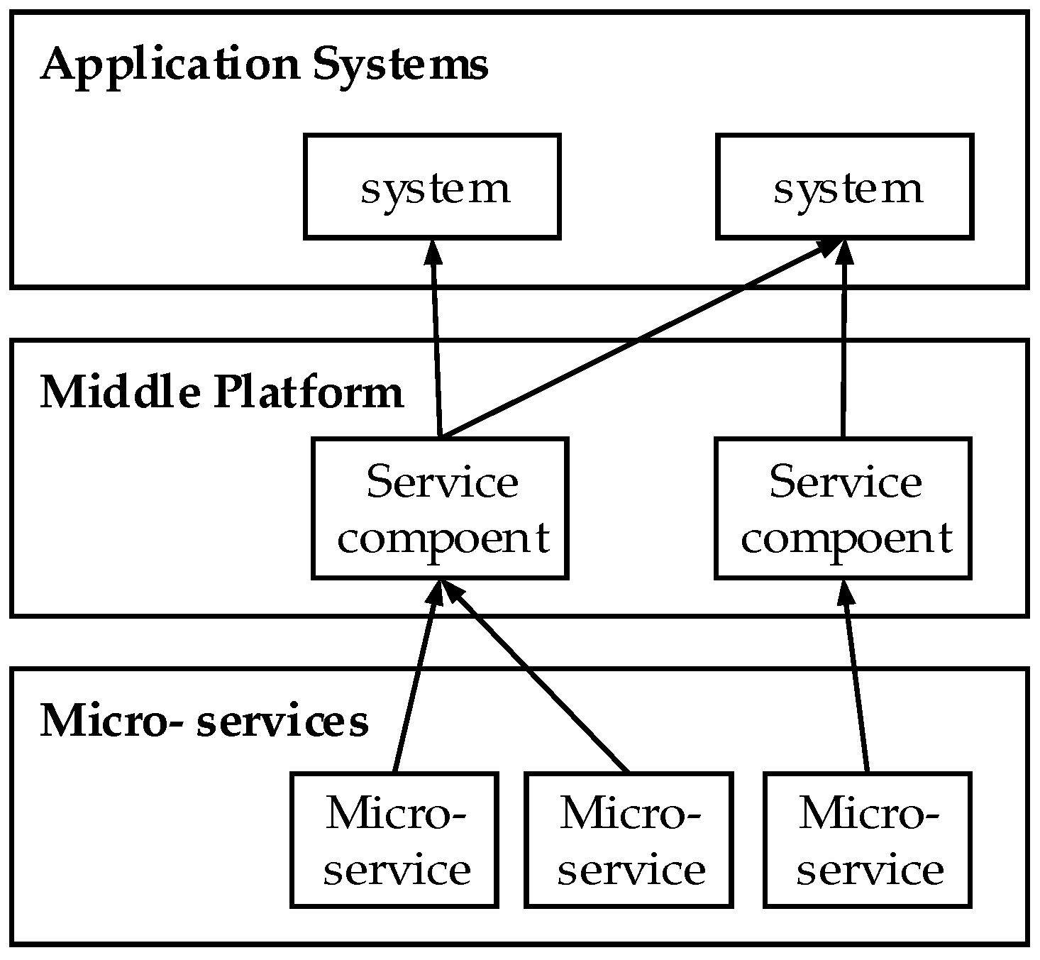
5]. The middle platform’s philosophy is to make common modules reusable for front-end applications. While the ideology of micro-service is to aim to be dismountable, extensible, and loosely connected when developing a common module. As shown in
Figure 1, based on the middle platform architecture of micro-services, the middle platform is divided into component units, which then break down into micro-services, then the application function is constructed through calls between micro-services, components, and application systems. The middle platform has the characteristics of componentization and modularization and can be delivered to the front-end application system to invoke the appropriate components to perform business operations. With micro-services laying on the fundamental of the middle platform, not only can the scalability and maintainability be enhanced but also the concurrent processing capabilities.
3. Business States and Demands
3.1. Business Demands
The Ministry of Natural Resources is responsible for overseeing dozens of government affairs, in terms of business fields, it divides into land use management, mineral rights management, and sea use management, while in terms of management type, it divides into approval and supervision tasks. For all types of affairs, the working process includes public declaration, government internal review and field inspection, public information inquiry, etc. Due to the substantial geographical property of natural resource management, there are intricate needs for spatial information verification at practically every administrative step. For now, spatial information verification is supported by the big data system of natural resources “One Map,” which with thousands of layers include basic geography, remote sensing images, and also other natural resource data of land, geology, minerals, oceans, forests, grasslands and wetlands, the amount of these data is constantly increasing and updating; this results in intricate needs for spatial information verification.
In order to address such intricate needs of spatial data verification requirements, the spatial information verification middle platform has advantages, which are capable of delivering highly reusable verification functions to different government management services and maintaining highly consistent verification rules.
3.2. Performance Demands
The government affairs management business’s geographical information verification function is quite complicated and subject to change. Additionally, the geographic information verification function’s access volume is growing rapidly year over year as a result of the expansion of business and data volume, creating a tremendous need for throughput. Furthermore, the administrative management’s need that the spatial information verification function be available online for 24 h brings in extra concerns regarding system stability. All these factors have brought higher performance requirements to the design and development of the middle platform.
Therefore, the spatial information verification middle platform must be able to expand quickly and perform updates as cheaply and quickly as possible. It also needs to have high reliability and be self-fault-tolerant in the event of a failure. Additionally, it must be able to handle a high throughput in the context of multiple users. Micro-service frameworks are a great option for meeting the aforementioned performance criteria since they have minimal coupling, high development efficiency, high scalability, and high fault tolerance when compared to typical monolithic frameworks.
4. Design of Geospatial Information VERIFICATION Platform
4.1. The Overall Architecture Design
This section demonstrates the architecture of a Natural Resource Administration and Geospatial Information Verification platform, which is built upon the notion of a middle platform and integrated with the business demands of natural resource administration and spatial information verification. The architecture of the middle platform is separated into the data layer, microservice layer, data, and business middle platform layer, and system application layer, as shown in
Figure 2.
Data support for the overall operation of the system is provided by the data layer, which contains “One Map” data and business attribute data. The micro-service layer contains the functionalities in the smallest granularity, such as spatial data services and spatial analysis services, through the basic information platform of territorial space, these functions are consolidated and made available for usage according to a unified resource catalog. The business middle platform has built function modules to provide general map service and verification functions in many business lines via mutual invocation and combining of micro-service layer functions. The verification of spatial information would subsequently be accomplished by the administrative systems at the application service layer by calling an interface from the business middle platform.
4.2. Design of Business Middle Platform
The business middle platform contains the Government Map Service middle platform, Spatial Information Verification middle platform, and Spatial Information Verification Configuration Management System.
The Government Map Service System provides universal map functions for all types of business application systems, such as map configuration, layer management, map browsing, map query, spatial analysis, visualization, and project batch demonstration, etc. In detail, map configuration connects layer data service sources and configures map symbols, while map browsing enables vector maps, raster maps, a 3-D Topographic map, Tianditu maps, and other types of map display operations. The map query module offers functions such as generic map layer spatial queries, layer attribute queries, project lot list queries, and more. The visualization module parses the lot coordinate information supplied from the verification process in either JSON or WKT format to complete the spatial map. In order to fulfill the discussion needs of a centralized meeting, the project batch demonstration module implements presentation functions that can manage a succession of batch graphics as well as the ability to quickly switch and browse between two- and three-dimensional maps.
The Spatial Information Verification middle platform provides a unified spatial verification service component, such as new verification task creation, task progress monitoring, and result viewing modules, that can be accessed by any governmental affairs application system. Before creating and submitting a new verification task, users must pass the authentication model’s identification. The task progress monitoring module is used to track the status of the verification in real time, and the result viewing module is used to view the verification data and report once it’s completed.
Through a graphical interface, the Spatial Information Configuration Management System delivers different functionalities, including rule costuming, model costuming, model testing, task management and monitoring, and many more. Individual verification rules can be customized to achieve business verification model customizations and facilitate dynamic extensions. The model might then be put to the test in the testing module to confirm its applicability. Verification tasks can be tracked and controlled to spot anomalies, and the system includes a module to help users deal with them. To migrate the verification model easier, the model porting module supports the import and export of rules and configurations.
Micro-services are used to implement the specialized functions of the business middle platform, which are invoked and coordinated with one another through the API gateway to construct the service functions of the business middle platform. The Spring Cloud micro-service framework is used to build unified management and precise governance of micro-services, as well as functions such as service circuit breaker and service flow limiting, which ensures the system’s stability.
4.3. Design of Data Middle Platform
The Data Middle Platform is just the Basic Information Platform of Territorial Space. It supplies the Business middle Platform with map data and spatial analytic functions.
The Basic Information Platform of Territorial Space has a distributed application and service architecture. Based on the registration, publication, scheduling, and monitoring services provided by the enterprise-level SOA service bus, it allows a distributed integration of physically dispersed data and services. The platform classifies natural resource data such as basic geography, land, mineral resources, geology, ocean, forest, grassland, and wetland based on the current status and future planning. This aided in the creation of a unified “One Map” of natural resource data and service requirements. Through service access, data sharing, and real-time filing, data from remote nodes are connected to the Basic Information Platform of Territorial Space for unified administration and application services.
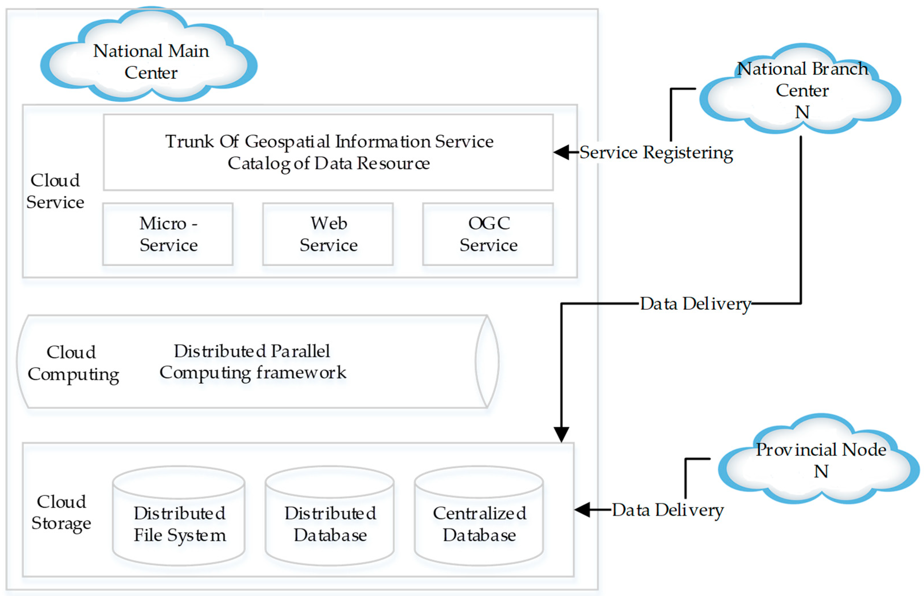
As shown in
Figure 3, natural resource big data are handled via a distributed technical infrastructure. Data interchange, data sharing, and service aggregation all take place in the national center. In terms of technology, the national main center uses a distributed database and a distributed parallel computing framework to achieve cloud storage and computing in order to enable cloud services with data access and computation. Cloud services use HTTP, Web Service, and OGC protocols to construct micro-services (RESTful API), conventional services, and OGC services to give information services to internal and external customers.
5. Practical Applications
Based on the above framework, the intelligent verification function for spatial information of construction land approval service is designed and developed. In the classic monomer structure, each service system builds and maintains its own set of verification functions and service verification criteria. Existing resources, in this way, cannot be reused, and development efficiency is very low, making it impossible to fulfill the demands of rapid change in business management. The spatial information intelligent verification function of the construction land approval business is created using the architecture described above, and it is a specific application example of the Natural Resource Administration and Geospatial Information Verification platform in practice.
5.1. Business Model
The Requirements for spatial information verification business of construction land approval are as follows:
Verification of the type of land use overlap. The basic land category is verified using data from the “Third National Land Resource Survey” in 2020, which includes legality verification of construction land, geology retrospective analysis of construction land with no legal sources, and category analysis for the previous year’s status (2019) of other agricultural lands. On top of the land category verification, the balance of arable land is checked on present arable land, and the dynamic equilibrium of arable lands is checked on other agricultural lands from the previous year as arable land.
Verification of Territorial space planning red line. It includes the verification of overlay permanent basic farmland and the overlay ecological red line. The spatial information verification business model, as illustrated in
Figure 4, is designed to mark the data analysis to be carried out and the data to be used, in accordance with the requirements of the spatial information verification business of construction land approval. The creation of the verification function is then based on the verification business model.
5.2. Development Process of Middle Platform
Use the middle platform to design the spatial information verification function of construction land approval based on the spatial information verification business model. As shown in
Figure 5, the application of the middle platform development process is separated into six stages: business modeling, data collection, service development, service registration, model configuration, and middle platform application.
The business modeling stage analyzes the business verification requirements in detail, including which data services should be used and which should be created, while also building business models (As shown in
Figure 4).
Missing data is collected in the middle platform according to service requirements during the data collecting stage.
The development of data and data analysis services is part of the data services developing stage. The development of data analysis services, on the one hand, is to develop single-layer analysis services, and on the other hand, is to develop multi-layer thematic analysis services, according to the requirement. Another example is the retroactive pre-geology analysis of construction land with no legal sources, which involves a multi-layer analysis of land use survey data from 2009 to 2018.
The service registration stage registers data services and data analysis services on the basic information platform of territorial space. In the stage of the business model configuration, through the verification configuration management system, the business middle platform configures each verification rule and business verification model. The verification rule is an individual data analysis service project, such as overlay analysis with 2020 land use status data. The Directed Acyclic Graph (DAG) is used to organize a set of verification rules in the business verification model. The configuration in middle platform of the map includes map data service source, map display symbol, and map layer display order.
In the middle platform application stage, the construction land approval system’s front-end development interface invokes the relevant modules of the business middle platform to implement the verification function, such as submitting tasks and obtaining status and results. The verification results of text and image integration are implemented using the map middle platform.
5.3. The Results of Middle Platform Application
The examples above demonstrate how the middle platform application may respond quickly to the needs and changes of the government affairs verification business. At the same time, the purpose of the middle platform is to achieve enterprise-level business capabilities and data reuse. The business functions and data that are regularly constructed in various business scenarios are deposited in the business and data middle platform. Based on the above-mentioned typical application scenarios, the verification function, data service, data analysis service, verification regulation model, verification of the business model, and map configuration are established, which can be reused by other businesses with the individual data replenish and simple configuration adjustments, has greatly improved development efficiency. At the same time, the reuse of data services and verification rules ensures the implementation of the unified base map and the unified verification rules.
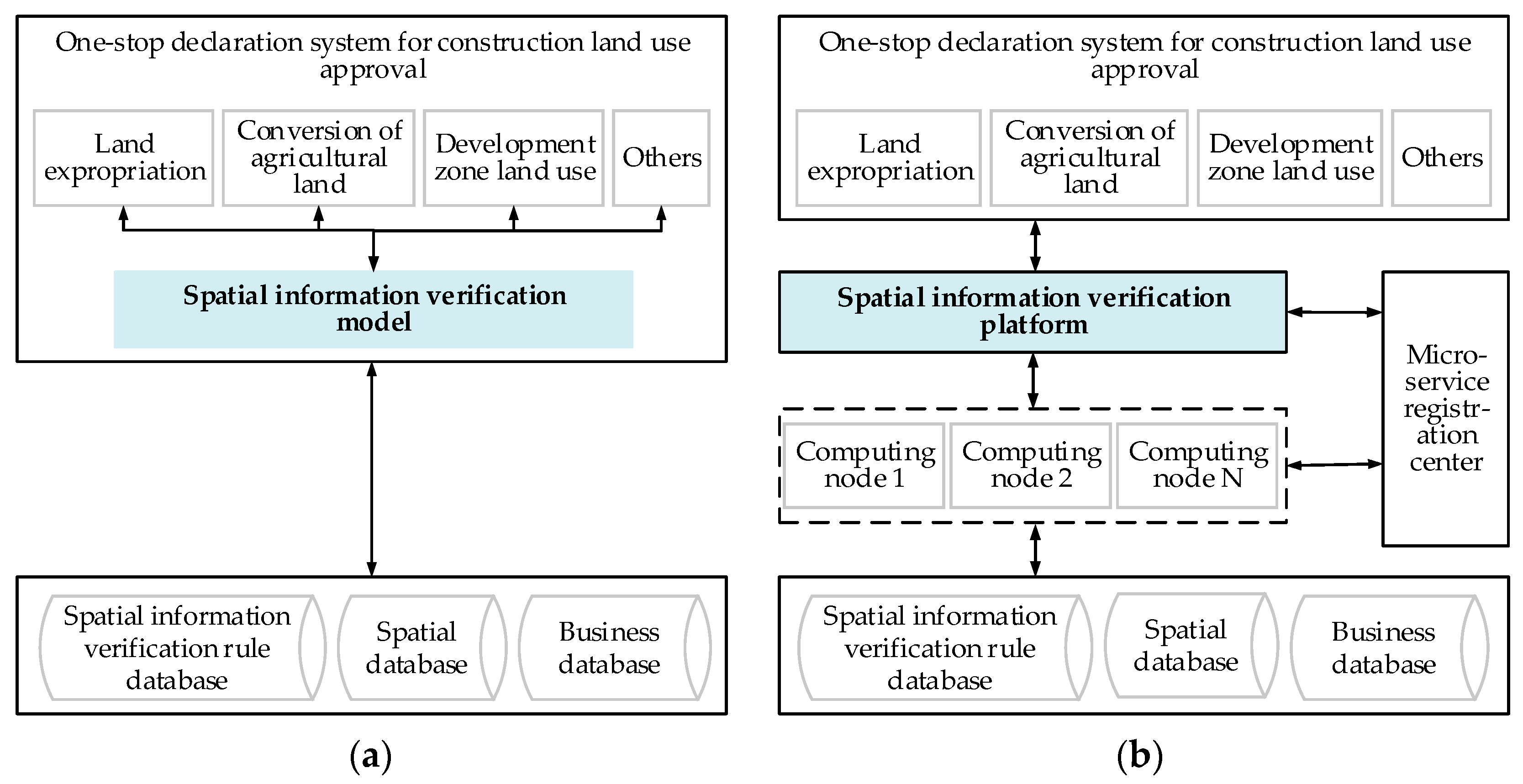
Taking the application of spatial information verification function in construction land use as an example, we contrasted the micro-service architecture with the conventional monolithic architecture.
Figure 6 compares the changes in system design.
As illustrated in
Figure 6a, in the classic monolithic architecture, the spatial information verification function works as a module of the one-stop declaration system, which is strongly coupled with other modules and inaccessible by the outside business system. Conversely, as seen in
Figure 6b, in the system based on the intermediate platform and micro-services, it forms an independent platform and is decoupled from other modules in the declaration system. By calling the service components of the intermediate platform, both the internal and external business systems could access the spatial information verification function.
Table 1 compares latency, reusability, reliability, scalability, throughput, and development cost.
6. Conclusions
This paper designs and implement a geospatial information verification platform for natural resource government affairs, it includes the business middle platform and data middle platform. Built on micro-services-based technology architecture, the business middle platform successfully establishes a highly reusable intelligent spatial information verification mechanism, which provides strong support for the front-end applications of various government affairs of natural resources. It avoids repetitive development, solves the problem of inconsistent verification rules caused by classical monolithic structure systems, and promotes scalability and parallel processing capacity. Relying on the Basic Information Platform of Territorial Space, the data middle platform chives an aggregation of distributed-managed spatial data services and spatial data analysis services, provides strong data support to the business middle platform, and resolves the big data computation problems. As well as, the attributes of the business middle platform and data middle platform are strictly distinguished, the data middle platform emphasizes the unification of data standards and caliber, and encapsulates data into services, such as database services, label portrait services, algorithm model services, etc., to support the front desk business more intelligent; The business middle platform emphasizes the efficient reuse of process and service. This makes the overall architecture more scalable, maintainable, and conducive to technological innovation. Over ten natural resource government approval proceedings have been successfully and steadily supported by the Geospatial Information Verification Middle Platform. The use of the middle platform streamlines the independent development status of each business line inside the original monolithic architectural system, which increases development effectiveness, lowers development costs, and achieves uniform spatial information verification rules. In contrast to a monolithic design, the micro-service architecture used offers a significant improvement in performance in terms of reliability, scalability, throughput, etc.
This article discussed the design and implementation of the Geospatial Information Verification Middle Platform in the context of the actual demand for Chinese natural resource government affairs management. The platform’s structure clearly distinguishes between the business platform and data platform, and, when combined with its use of the micro-service architecture, functionality and performance have both been significantly enhanced. As a result, this architectural design provides a practical solution for application scenarios involving intricate spatial big data analysis.
The space information verification middle platform still faces some challenges, which need to be paid attention to and improved in future research. The first challenge is to accurately define the boundaries between the middle platform and the front-end business system. To increase reusability and ensure consistent administration, the middle platform should be created using global common functions. Second, it might be difficult to define a suitable level of granularity for micro-services. They must base on the business model and, especially, each of them should try to avoid distributed transactions in order to ensure strong data consistency. Finally, as micro-services increase in quantity and complexity, monitoring and governance may become necessary to enhance system stability.
Author Contributions
Conceptualization, Junjie Zhou, Fanrong Meng, Dengkui Kong and Min Yao; methodology, Junjie Zhou, Fanrong Meng, Dengkui Kong, Min Yao, Xuchun Liu, Kongyi Wu, Xuefei Wang and Yike Guo; software, Fanrong Meng, Dengkui Kong, Min Yao, Kongyi Wu, Xuefei Wang and Yike Guo; validation, Fanrong Meng, Dengkui Kong, Min Yao, Kongyi Wu, Xuefei Wang and Yike Guo; formal analysis, Fanrong Meng, Dengkui Kong, Min Yao, Kongyi Wu, Xuefei Wang and Yike Guo; investigation, Fanrong Meng, Dengkui Kong, Min Yao and Junjie Zhou; writing—original draft preparation, Junjie Zhou, Fanrong Meng, Dengkui Kong and Min Yao; writing—review and editing, Junjie Zhou, Fanrong Meng, Dengkui Kong, Min Yao, Xuchun Liu, Kongyi Wu, Xuefei Wang and Yike Guo; visualization, Fanrong Meng; supervision, Junjie Zhou. All authors have read and agreed to the published version of the manuscript.
Funding
This research received no external funding.
Institutional Review Board Statement
Not applicable.
Informed Consent Statement
Not applicable.
Data Availability Statement
Not applicable.
Acknowledgments
All authors thank the anonymous reviewers for review the manuscript.
Conflicts of Interest
The authors declare no conflict of interest.
References
- Ministry of Natural Resources. General Plan for Informatization Construction of Ministry of Natural Resources. China Government Website. Available online: http://www.gov.cn/xinwen/2019-11/23/content_5454833.htm (accessed on 23 November 2019).
- Wu, J.; Liu, G.; Xi, C. Study on Service Oriented Architecture Based on Web Service. Mod. Electron. Technol. 2005, 14, 1–4. [Google Scholar]
- Feng, Z.; Xu, Y.; Xue, X.; Chen, S. Review on the Development of Microservice Architecture. J. Comput. Res. Dev. 2020, 57, 1103–1122. [Google Scholar] [CrossRef]
- Zhong, H. The Transformation of IT Framework in Enterprises. In The Strategic Thinking and Framework of Alibaba; China Machine Press: Beijing, China, 2017. [Google Scholar]
- Ou, C.; Deng, D. Midplatform Architecture and Implementation. In Based on DDD and Microservices; China Machine Press: Beijing, China, 2020. [Google Scholar]
- Chi, W.; Shi, L.; Liu, Z.; Zhu, M. Research on Technical Solution of Business Rules Platform and Rule Migration Method in Microservice Architecture. Mod. Comput. 2021, 6, 42–45. [Google Scholar] [CrossRef]
- Zhang, W.T.; Jin, L.K. Discussion on the Intelligent Water Construction Based on the Thought of Middle Platform. Water Wastewater Eng. 2021, 47, 538–544. [Google Scholar] [CrossRef]
- Qiu, A.; Zhang, Y.; Luo, N. Design and Implementation of Integrated Disaster Reduction Intelligent Service System Based on Microservice Architecture and Middle Platform Concept. Geomat. Inf. Sci. Wuhan Univ. 2020, 45, 1288–1295. [Google Scholar] [CrossRef]
- Zhu, B.; Zhang, C.; Yu, J. Construction and application of natural resources inspection platform based on middle platform architecture. Nat. Resour. Informatiz. 2021, 1, 37–43. [Google Scholar]
- Chen, H. Design on Business Middle Platform Based on Domain-driven and Microservice for High-speed Railway Train Control Simulation Test System. Railw. Stand. Des. 2021, 66, 1–7. [Google Scholar] [CrossRef]
- Feng, W.; Tian, W.; Yang, W. Design of financial Sharing management Platform based on micro service and Zhongtai Concept. Financ. Account. Newsl. 2022, 6, 167–171. [Google Scholar] [CrossRef]
- Thönes, J. Microservices. IEEE Softw. 2015, 32, 116. [Google Scholar] [CrossRef]
- Yu, H. Information resource service platform based on microservice architecture. Sci. Technol. Manag. Res. 2019, 13, 211–216. [Google Scholar] [CrossRef]
- Li, G. What Is Data Middle Platform? Inf. China 2019, 6, 72–75. [Google Scholar]
| Publisher’s Note: MDPI stays neutral with regard to jurisdictional claims in published maps and institutional affiliations. |
© 2022 by the authors. Licensee MDPI, Basel, Switzerland. This article is an open access article distributed under the terms and conditions of the Creative Commons Attribution (CC BY) license (https://creativecommons.org/licenses/by/4.0/).


