
An ANNs-Based Method for Automated Labelling of Schematic Metro Maps


Abstract
:1. Introduction
2. Automated Labelling of Maps: An Analysis of Existing Methods and a Strategy
2.1. Analysis of Existing Automated Labelling Methods for Maps
2.2. A Strategy Based on Artificial Neural Networks
- The samples of name label placement are extracted from existing schematic maps;
- The acquired samples are used to train and test artificial neural networks for automated labelling.
3. Models, Input, and Output of ANNs for Automated Labelling
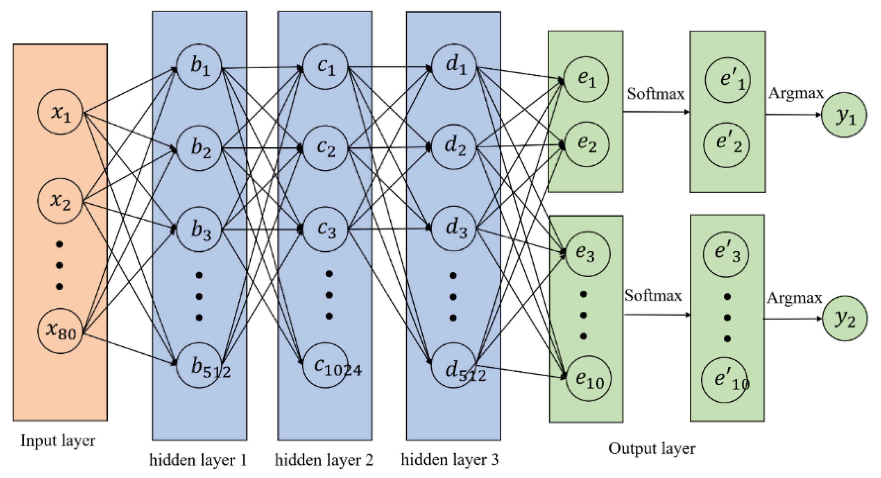
3.1. Basic Models and Parameters of ANNs
3.2. Input Attributes for ANNs
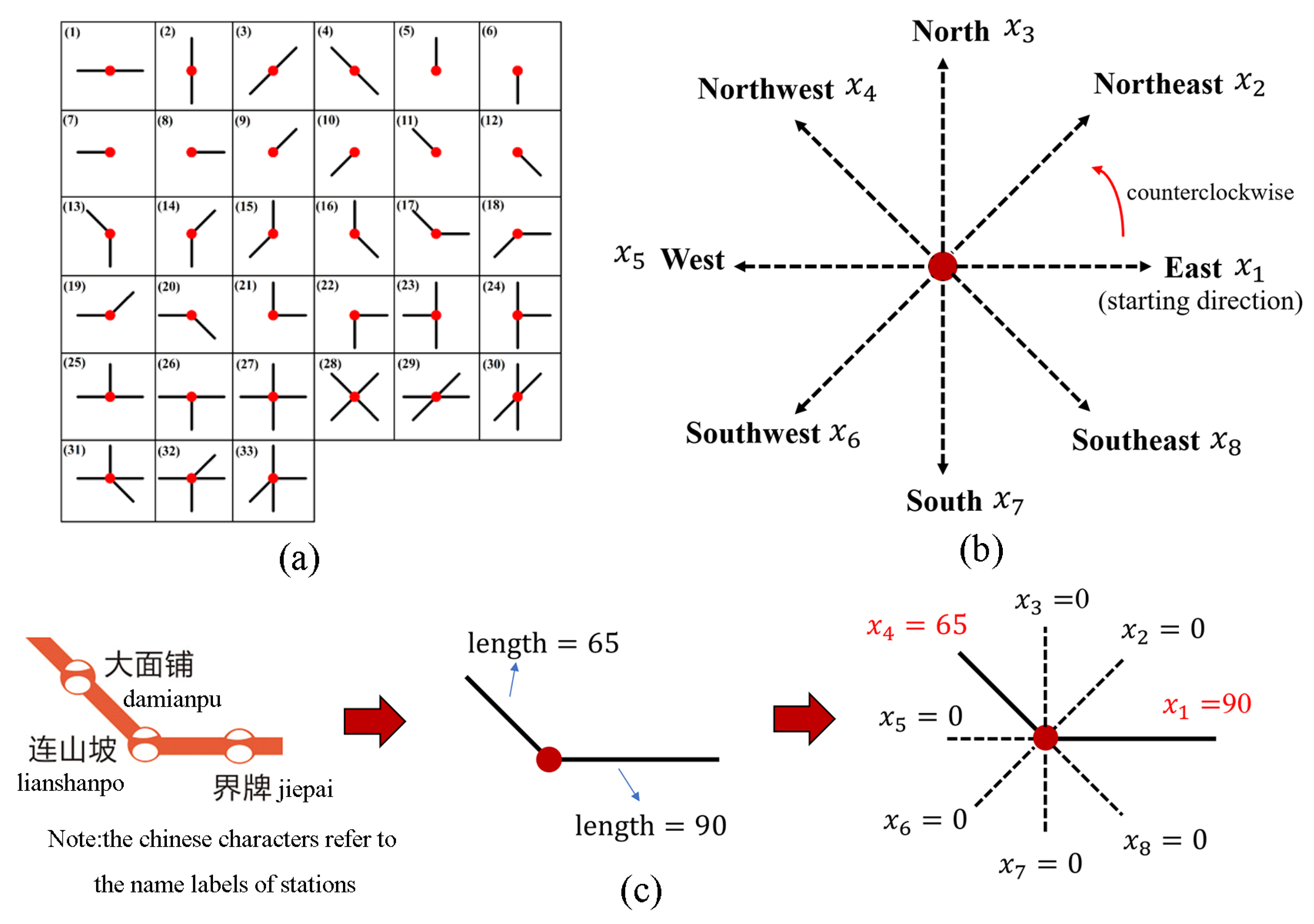
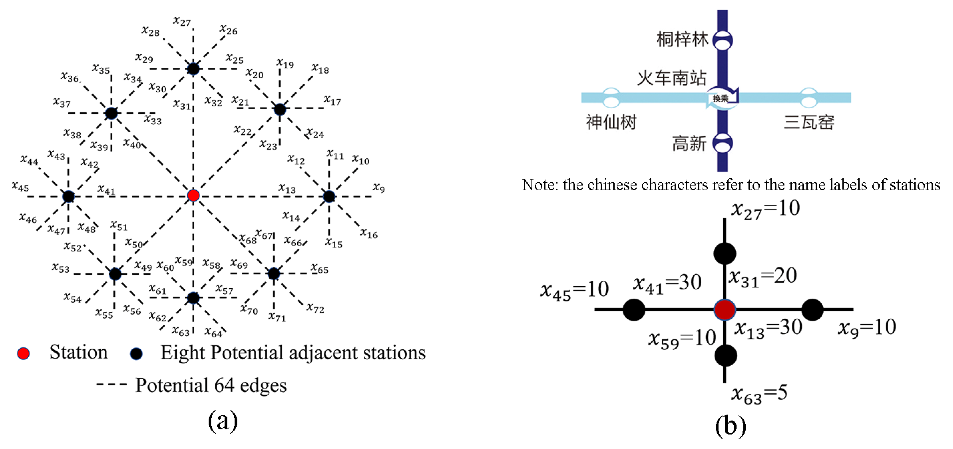
- Station-Based Line Relations
- Connection relations between adjacent stations and edges
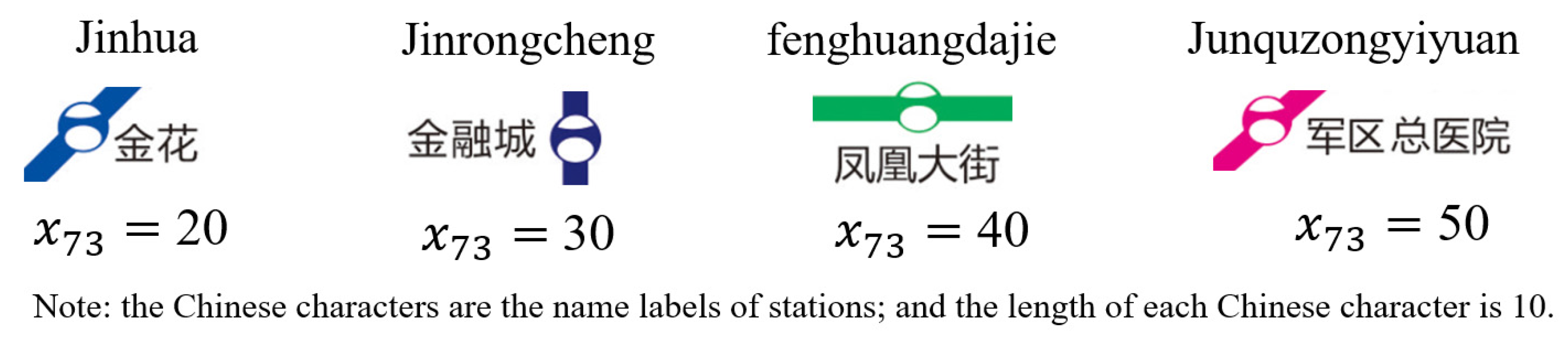
- Lengths of name labels
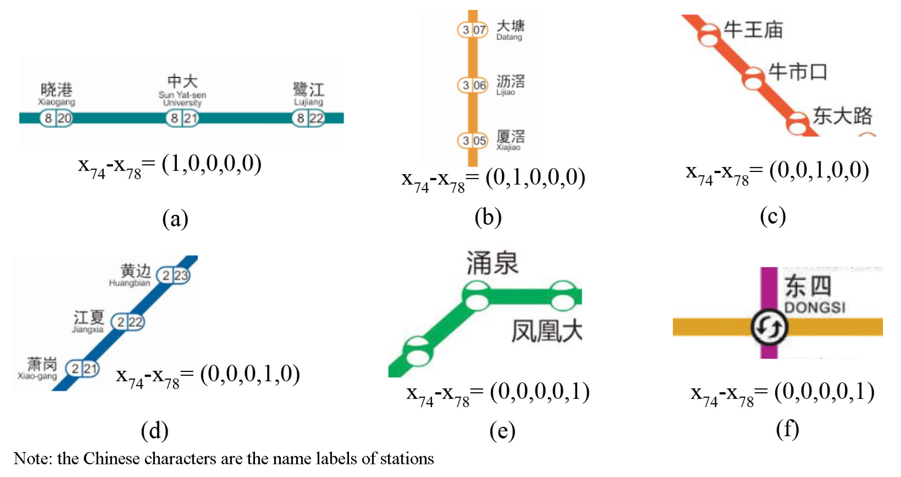
- Directions of operation lines
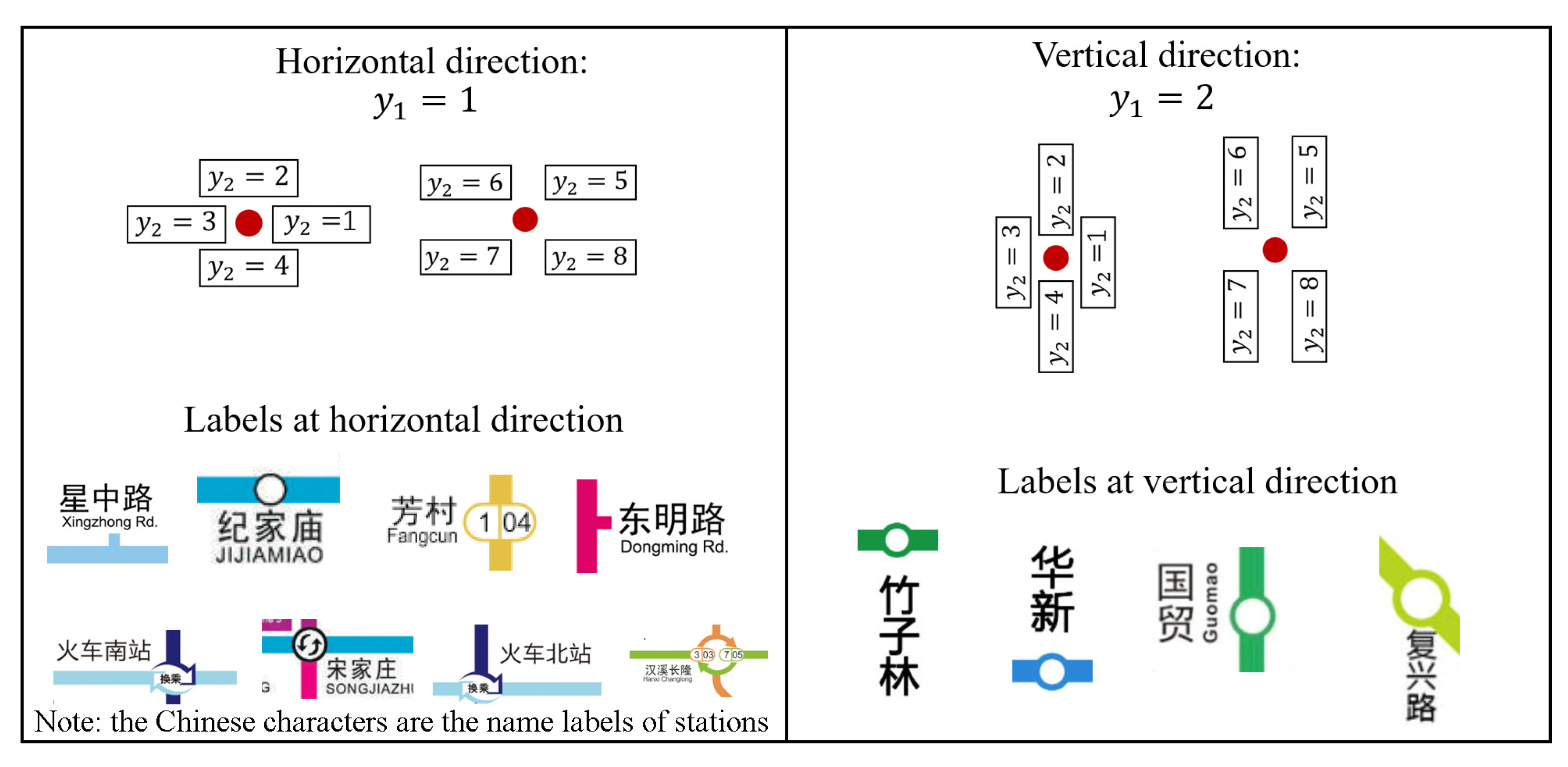
- Coordinates of points
3.3. Output Attributes for ANNs
4. Training and Testing ANNs Models for Automated Labelling
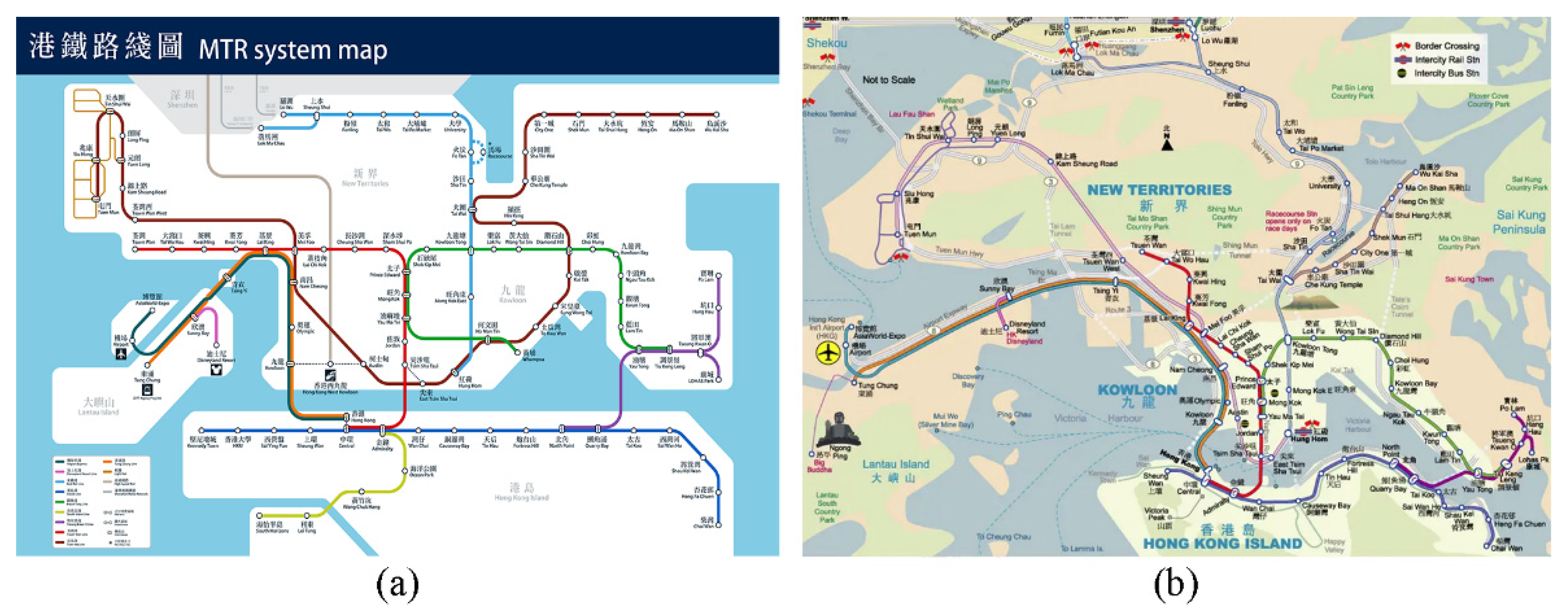
4.1. Training and Testing Dataset
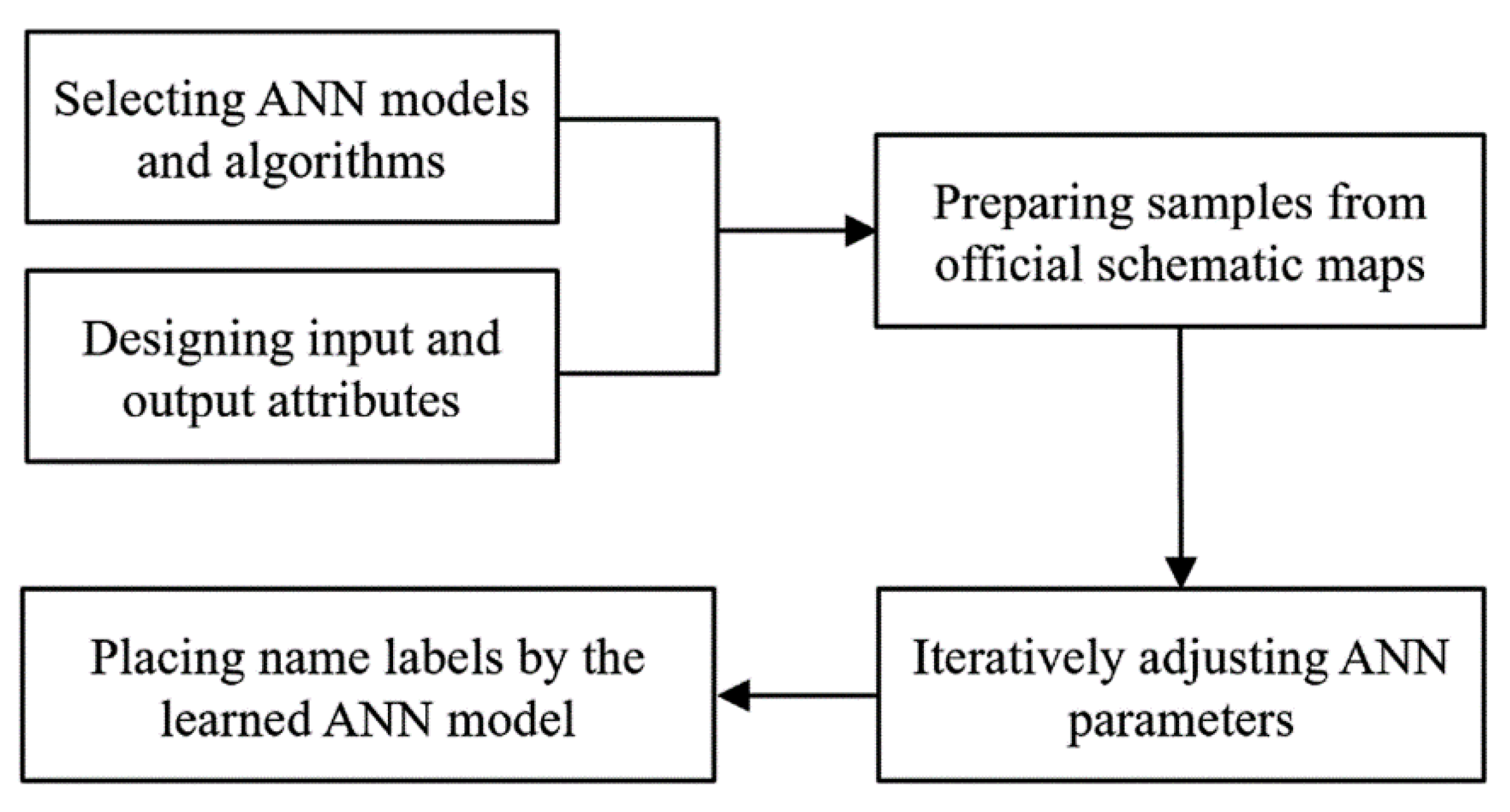
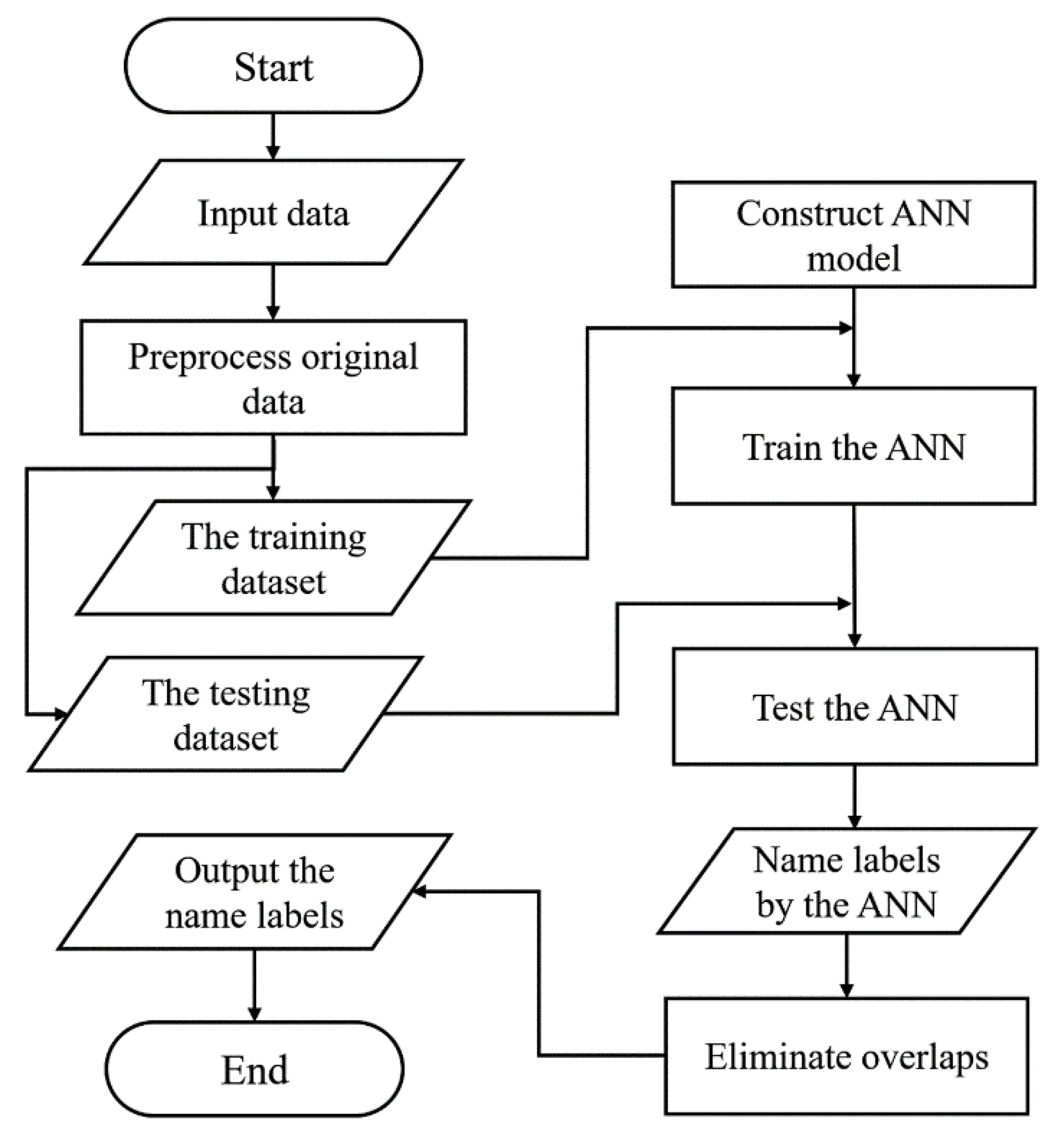
4.2. Implementation of the ANNs-Based Method for Automated Labelling
- Preprocessing the original data
- Constructing the ANNs model using Python and PyTorch
- Training and testing the ANNs model
- Eliminate overlaps
5. Experimental Evaluation
5.1. Experimental Design
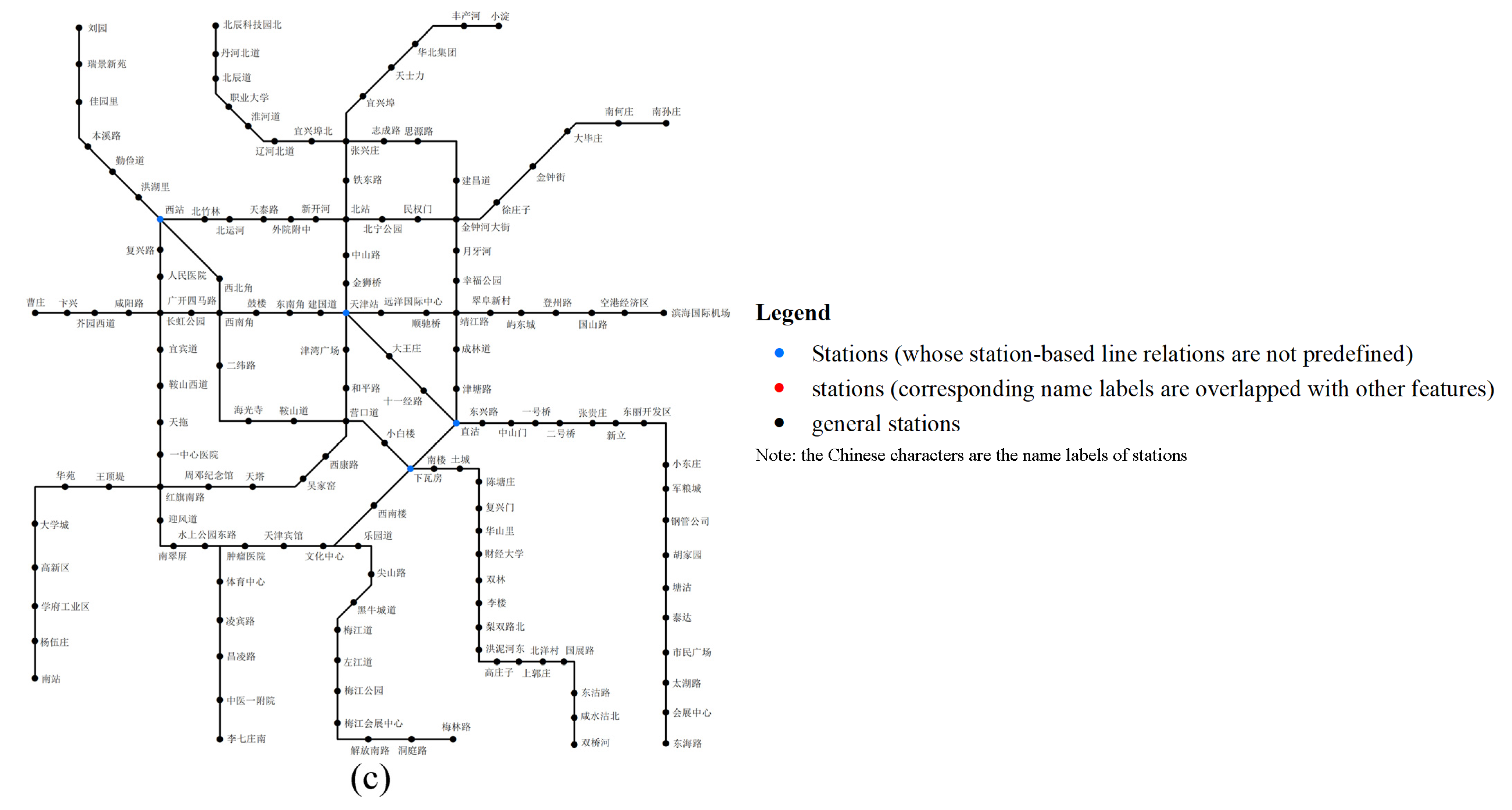
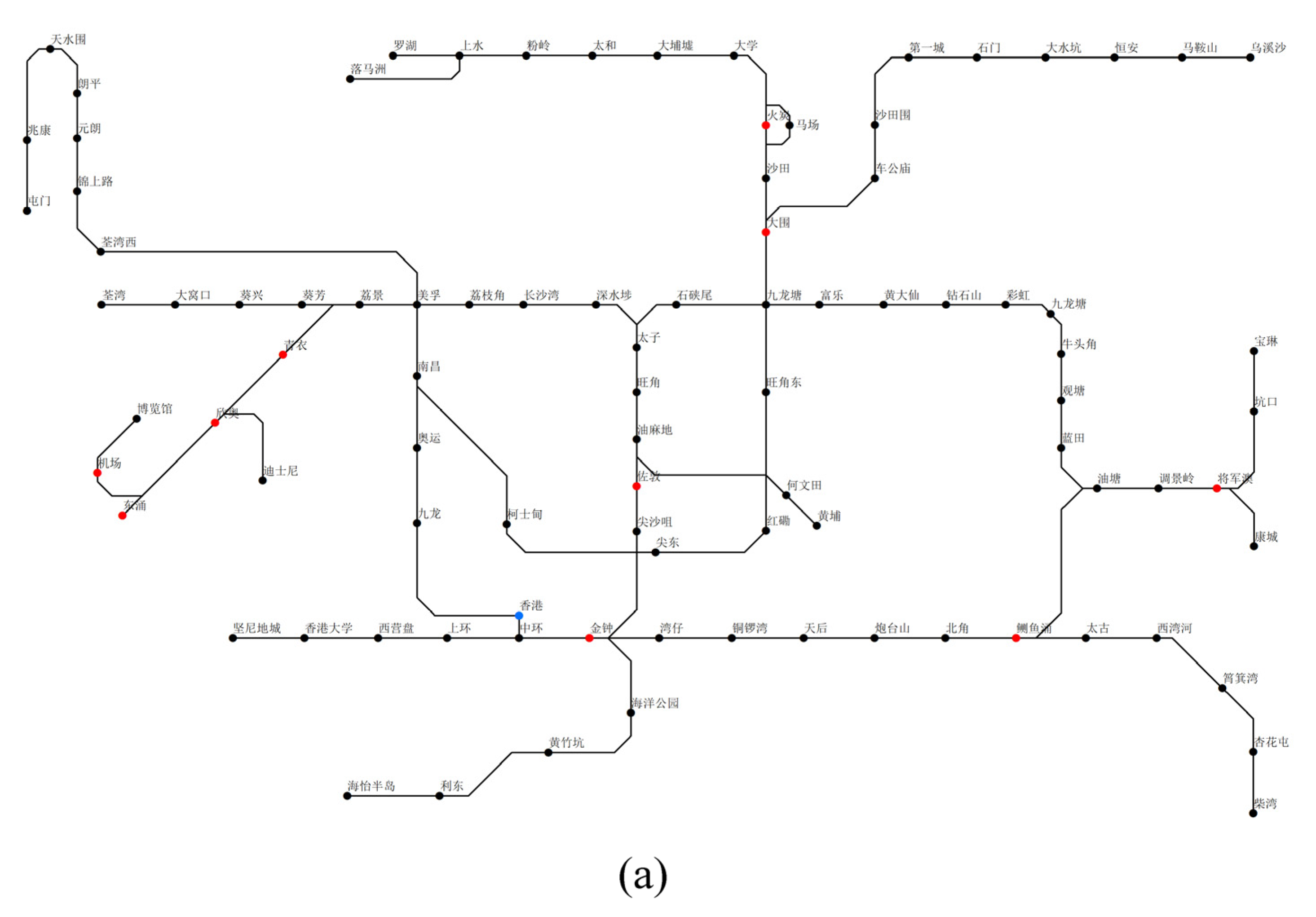
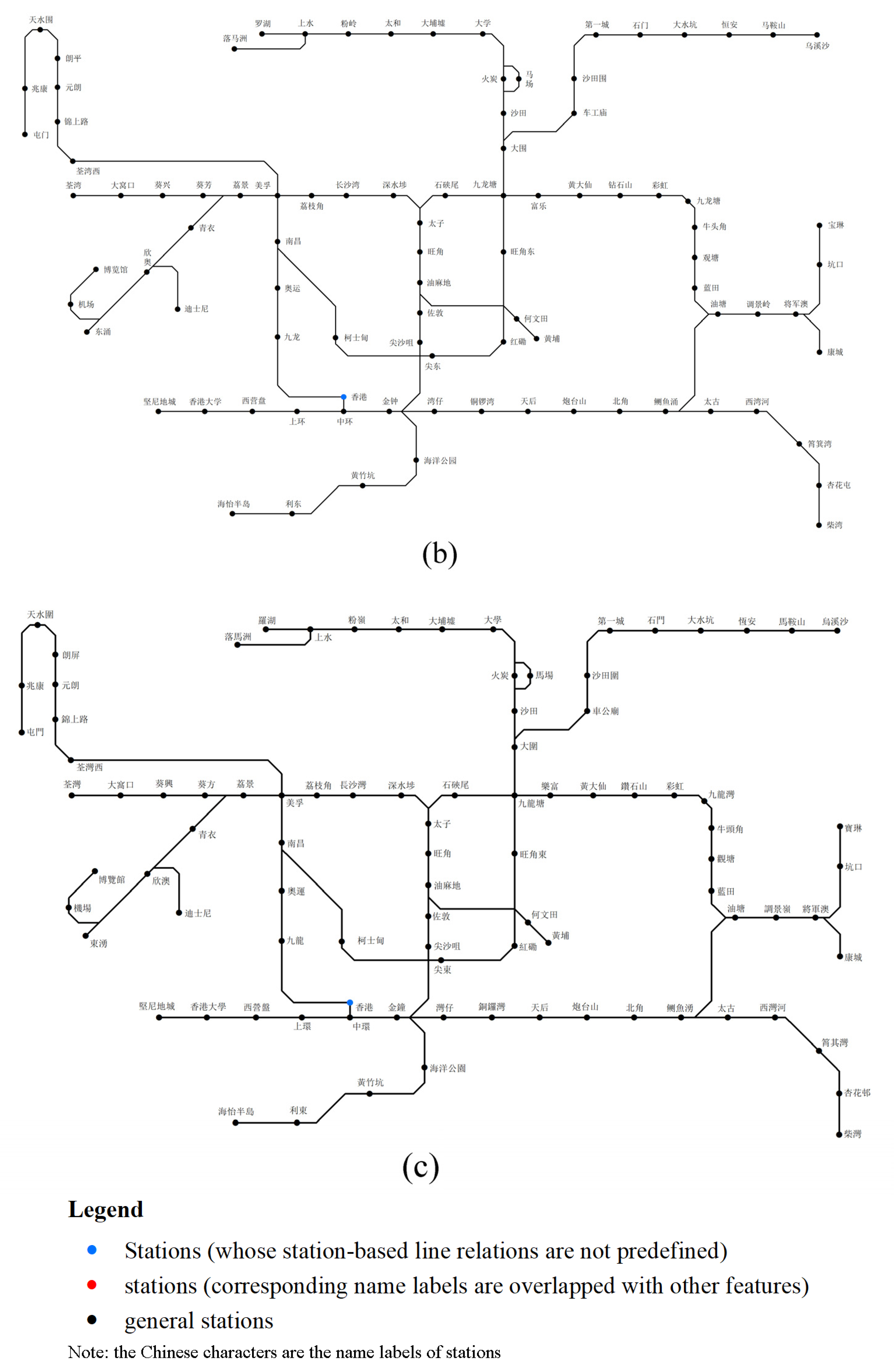
- Experimental data and benchmark
- Measures
5.2. Experimental Results
6. Conclusions
Author Contributions
Funding
Institutional Review Board Statement
Informed Consent Statement
Data Availability Statement
Acknowledgments
Conflicts of Interest
References
- Avelar, S. Schematic Maps on Demand: Design, Modeling and Visualization. Ph.D. Thesis, ETH Zürich, Zürich, Switzerland, 2002. [Google Scholar]
- Forrest, D. Causes and consequences of scale change in schematic maps: Are users aware and do they care? In Proceedings of the 1st Schematic Mapping Workshop, Essex, UK, 2–3 April 2014. [Google Scholar]
- Hong, S.-H.; Merrick, D.; Nascimento, H.A. Automatic visualisation of metro maps. J. Vis. Lang. Comput. 2006, 17, 203–224. [Google Scholar] [CrossRef]
- Anand, S.; Avelar, S.; Ware, J.M.; Jackson, M. Automated schematic map production using simulated annealing and gradient descent approaches. In Proceedings of the Geographical Information Science Research UK 15th Annual Conference, Maynooth, UK, 11–13 April 2007; pp. 414–420. [Google Scholar]
- Dong, W.H.; Guo, Q.S.; Liu, J.P. Schematic road network map progressive generalization based on multiple constraints. Geo-Spat. Inf. Sci. 2008, 11, 215–220. [Google Scholar] [CrossRef]
- Dong, W.H.; Li, Z.L.; Guo, Q.S. Automated Model Generalization of Schematic Network Maps Based on Dynamic Segmentation. Geomat. Inf. Sci. Wuhan Univ. 2010, 35, 892–895. [Google Scholar]
- Ware, M.; Richards, N. An ant colony system algorithm for automatically schematizing transport network data sets. In Proceedings of the IEEE Congress on Evolutionary Computation, Cancún, Mexico, 20–23 June 2013; pp. 1892–1900. [Google Scholar]
- Ti, P.; Li, Z.; Xu, Z. Automated generation of schematic network maps adaptive to display sizes. Cartogr. J. 2015, 52, 168–176. [Google Scholar] [CrossRef]
- Galvao, M.; Ramos, F.; Lamar, M.; Taco, P. Dynamic Visualization of Transit Information Using Genetic Algorithms for Path Schematization. In Proceedings of the GIS Ostrava, Ostrava, Czech Republic, 22–24 March 2017; pp. 99–113. [Google Scholar]
- Li, J.T.; Jia, C.L.; Zhang, L.; Li, X.K.; Li, Y.Y.; Luo, F.L. Generating Schematic Network Maps by Simplification and Partition. Geomat. Inf. Sci. Wuhan Univ. 2017, 42, 721–725. [Google Scholar]
- Lan, T.; Li, Z.L.; Ti, P. Integrating general principles into mixed-integer programming to optimize schematic network maps. Int. J. Geogr. Inf. Sci. 2019, 33, 2305–2333. [Google Scholar] [CrossRef]
- Lan, T.; Li, Z.L.; Peng, Q.; Gong, X.Y. Automated labeling of schematic maps by optimization with knowledge acquired from existing maps. Trans. GIS 2020, 24, 1722–1739. [Google Scholar] [CrossRef]
- Guan, Q.; Wang, L.; Clarke, K.C. An Artificial-Neural-Network-based, Constrained CA Model for Simulating Urban Growth. Cartogr. Geogr. Inf. Sci. 2005, 32, 369–380. [Google Scholar] [CrossRef] [Green Version]
- Almeida, C.M.; Gleriani, J.M.; Castejon, E.F.; Soares, B. Using neural networks and cellular automata for modelling intra-urban land-use dynamics. Int. J. Geogr. Inf. 2008, 22, 943–963. [Google Scholar]
- Wang, J.; Mountrakis, G. Developing a multi-network urbanization model: A case study of urban growth in Denver, Colorado. Int. J. Geogr. Inf. Sci. 2011, 25, 229–253. [Google Scholar] [CrossRef] [Green Version]
- Zhai, Y.; Yao, Y.; Guan, Q.; Liang, X.; Li, X.; Pan, Y.; Yue, H.; Yuan, Z.; Zhou, J. Simulating urban land use change by integrating a convolutional neural network with vector-based cellular automata. Int. J. Geogr. Inf. Sci. 2020, 34, 1475–1499. [Google Scholar] [CrossRef]
- Zhou, Q.; Li, Z. Use of artificial neural networks for selective omission in updating road networks. Cartogr. J. 2014, 51, 38–51. [Google Scholar] [CrossRef]
- Wang, Y.; Chen, D.; Zhao, Z.; Ren, F.; Du, Q. A Back-Propagation Neural Network-Based Approach for Multi-Represented Feature Matching in Update Propagation. Trans. Gis Tg 2015, 19, 964–993. [Google Scholar] [CrossRef]
- Chou, T.Y.; Hoang, T.V.; Fang, Y.M.; Nguyen, Q.; Bui, Q.T. Swarm-based optimizer for convolutional neural network: An application for flood susceptibility mapping. Trans. GIS 2020, 25, 1009–1026. [Google Scholar] [CrossRef]
- Saeedimoghaddam, M.; Stepinski, T.F. Automatic extraction of road intersection points from USGS historical map series using deep convolutional neural networks. Int. J. Geogr. Inf. Sci. 2020, 34, 947–968. [Google Scholar] [CrossRef]
- Schnürer, R.; Sieber, R.; Schmid-Lanter, J.; Öztireli, A.C.; Hurni, L. Detection of Pictorial Map Objects with Convolutional Neural Networks. Cartogr. J. 2020, 58, 50–68. [Google Scholar] [CrossRef]
- Chirie, F. Automated name placement with high cartographic quality: City street maps. Cartogr. Geogr. Inf. Sci. 2000, 27, 101–110. [Google Scholar] [CrossRef]
- Yoeli, P. The logic of automated map lettering. Cartogr. J. 1972, 9, 99–108. [Google Scholar] [CrossRef]
- Christensen, J.; Marks, J.; Shieber, S. An empirical study of algorithms for point-feature label placement. ACM Trans. Graph. (TOG) 1995, 14, 203–232. [Google Scholar] [CrossRef] [Green Version]
- Raidl, G. A genetic algorithm for labeling point features. In Proceedings of the International Conference on Imaging Science, Systems, and Technology, Las Vegas, NV, USA, 6–9 July 1998; pp. 189–196. [Google Scholar]
- Yamamoto, M.; Camara, G.; Lorena, L.A.N. Tabu search heuristic for point-feature cartographic label placement. GeoInformatica 2002, 6, 77–90. [Google Scholar] [CrossRef]
- Klau, G.W.; Mutzel, P. Optimal labeling of point features in rectangular labeling models. Math. Program. 2003, 94, 435–458. [Google Scholar] [CrossRef]
- Cravo, G.L.; Ribeiro, G.M.; Lorena, L.A.N. A greedy randomized adaptive search procedure for the point-feature cartographic label placement. Comput. Geosci. 2008, 34, 373–386. [Google Scholar] [CrossRef]
- Do Nascimento, H.A.; Eades, P. User hints for map labeling. J. Vis. Lang. Comput. 2008, 19, 39–74. [Google Scholar] [CrossRef]
- Doddi, S.; Marathe, M.V.; Mirzaian, A.; Moret, B.M.; Zhou, B. Map labeling and its generalizations. In Proceedings of the Annual Association for Computing Machinery (ACM)-Society for Industrial and Applied Mathematics (SIAM) Symposium on Discrete Algorithms, New Orleans, LA, USA, 5–7 January 1997; pp. 148–157. [Google Scholar]
- Van Kreveld, M.; Strijk, T.; Wolff, A. Point labeling with sliding labels. Comput. Geom. 1999, 13, 21–47. [Google Scholar] [CrossRef] [Green Version]
- Kameda, T.; Imai, K. Map label placement for points and curves. IEICE Trans. Fundam. Electron. Commun. Comput. Sci. 2003, 86, 835–840. [Google Scholar]
- Ebner, D.; Klau, G.W.; Weiskircher, R. Label Number Maximization in the Slider Model. In Proceedings of the International Symposium on Graph Drawing, New York, NY, USA, 29 September–2 October 2004; pp. 144–154. [Google Scholar]
- Poon, S.-H.; Shin, C.-S.; Strijk, T.; Uno, T.; Wolff, A. Labeling points with weights. Algorithmica 2004, 38, 341–362. [Google Scholar] [CrossRef]
- Schwartges, N.; Haunert, J.-H.; Wolff, A.; Zwiebler, D. Point labeling with sliding labels in interactive maps. In Connecting a Digital Europe Through Location and Place; Springer: Berlin/Heidelberg, Germany, 2014; pp. 295–310. [Google Scholar]
- Schwartges, N.; Wolff, A.; Haunert, J.-H. Labeling streets in interactive maps using embedded labels. In Proceedings of the 22nd ACM Sigspatial International Conference on Advances in Geographic Information Systems, Dallas, TX, USA, 4–7 November 2014; pp. 517–520. [Google Scholar]
- Nöllenburg, M.; Wolff, A. Drawing and labeling high-quality metro maps by mixed-integer programming. IEEE Trans. Vis. Comput. Graph. 2011, 17, 626–641. [Google Scholar] [CrossRef] [PubMed] [Green Version]
- Wu, H.Y.; Takahashi, S.; Hirono, D.; Arikawa, M.; Lin, C.C.; Yen, H.C. Spatially efficient design of annotated metro maps. In Proceedings of the Computer Graphics Forum, Portland, OR, USA, 22–25 April 2013; pp. 261–270. [Google Scholar]
- Stott, J.M.; Rodgers, P.; Martinez-Ovando, J.C.; Walker, S.G. Automatic metro map layout using multicriteria optimization. IEEE Trans. Vis. Comput. Graph. 2011, 17, 101–114. [Google Scholar] [CrossRef] [PubMed] [Green Version]
- Wang, Y.-S.; Chi, M.-T. Focus+ context metro maps. IEEE Trans. Vis. Comput. Graph. 2011, 17, 2528–2535. [Google Scholar] [CrossRef] [PubMed]
- Wu, H.Y.; Takahashi, S.; Lin, C.C.; Yen, H.C. Travel-Route-Centered Metro Map Layout and Annotation. In Proceedings of the Computer Graphics Forum, Oxford, UK, 5–8 June 2012; pp. 925–934. [Google Scholar]
- Huang, B.; Zhao, B.; Song, Y. Urban land-use mapping using a deep convolutional neural network with high spatial resolution multispectral remote sensing imagery. Remote Sens. Environ. 2018, 214, 73–86. [Google Scholar] [CrossRef]
- Kemker, R.; Salvaggio, C.; Kanan, C. Algorithms for semantic segmentation of multispectral remote sensing imagery using deep learning. ISPRS J. Photogramm. Remote Sens. 2018, 145, 60–77. [Google Scholar] [CrossRef] [Green Version]
- Wang, S.; Quan, D.; Liang, X.; Ning, M.; Guo, Y.; Jiao, L. A deep learning framework for remote sensing image registration. ISPRS J. Photogramm. Remote Sens. 2018, 145, 148–164. [Google Scholar] [CrossRef]
- Hughes, L.H.; Marcos, D.; Lobry, S.; Tuia, D.; Schmitt, M. A deep learning framework for matching of SAR and optical imagery. ISPRS J. Photogramm. Remote Sens. 2020, 169, 166–179. [Google Scholar] [CrossRef]
- Shao, Z.; Cai, J. Remote sensing image fusion with deep convolutional neural network. IEEE J. Sel. Top. Appl. Earth Obs. Remote Sens. 2018, 11, 1656–1669. [Google Scholar] [CrossRef]
- Chen, Y.; Shi, K.; Ge, Y. Spatiotemporal Remote Sensing Image Fusion Using Multiscale Two-Stream Convolutional Neural Networks. IEEE Trans. Geosci. Remote Sens. 2021, 60, 1–12. [Google Scholar] [CrossRef]
- Schlemper, J.; Caballero, J.; Hajnal, J.V.; Price, A.N.; Rueckert, D. A deep cascade of convolutional neural networks for dynamic MR image reconstruction. IEEE Trans. Med. Imaging 2017, 37, 491–503. [Google Scholar] [CrossRef] [Green Version]
- Wang, Z.; Chen, J.; Hoi, S.C. Deep learning for image super-resolution: A survey. IEEE Trans. Pattern Anal. Mach. Intell. 2020, 43, 10. [Google Scholar] [CrossRef] [Green Version]
- Rigol, J.P.; Jarvis, C.H.; Stuart, N. Artificial neural networks as a tool for spatial interpolation. Int. J. Geogr. Inf. Sci. 2001, 15, 323–343. [Google Scholar] [CrossRef]
- Merwin, D.A.; Cromley, R.G.; Civco, D.L. Artificial Neural Networks as a Method of Spatial Interpolation for Digital Elevation Models. Am. Cartogr. 2002, 29, 99–110. [Google Scholar] [CrossRef]
- Merwin, D.; Cromley, R.; Civco, D. A Neural Network-based Method for Solving “Nested Hierarchy” Areal Interpolation Problems. Am. Cartogr. 2009, 36, 347–365. [Google Scholar] [CrossRef]
- Zhu, D.; Cheng, X.; Zhang, F.; Yao, X.; Gao, Y.; Liu, Y. Spatial interpolation using conditional generative adversarial neural networks. Int. J. Geogr. Inf. Sci. 2020, 34, 735–758. [Google Scholar] [CrossRef]
- Steiger, E.; Resch, B.; Zipf, A. Exploration of spatiotemporal and semantic clusters of Twitter data using unsupervised neural networks. Int. J. Geogr. Inf. Sci. 2015, 30, 1694–1716. [Google Scholar] [CrossRef]
- Hagenauer, J.; Helbich, M. SPAWNN: A Tool kit for SPatial Analysis with Self-Organizing Neural Networks. Trans. Gis 2016, 20, 755–774. [Google Scholar] [CrossRef]
- Lin, Y.P.; Chu, H.J.; Wu, C.F.; Verburg, P.H. Predictive ability of logistic regression, auto-logistic regression and neural network models in empirical land-use change modeling—A case study. Int. J. Geogr. Inf. Syst. 2010, 25, 65–87. [Google Scholar] [CrossRef] [Green Version]
- Shi, W.; Liu, Z.; An, Z.; Chen, P. RegNet: A neural network model for predicting regional desirability with VGI data. Int. J. Geogr. Inf. Sci. 2020, 25, 175–192. [Google Scholar] [CrossRef]
- Wu, S.; Wang, Z.; Du, Z.; Huang, B.; Liu, R. Geographically and temporally neural network weighted regression for modeling spatiotemporal non-stationary relationships. Int. J. Geogr. Inf. Sci. 2020, 35, 582–608. [Google Scholar] [CrossRef]
- Feng, Y.; Thiemann, F.; Sester, M. Learning cartographic building generalization with deep convolutional neural networks. ISPRS Int. J. Geo-Inf. 2019, 8, 258. [Google Scholar] [CrossRef] [Green Version]
- Touya, G.; Zhang, X.; Lokhat, I. Is deep learning the new agent for map generalization? Int. J. Cartogr. 2019, 5, 142–157. [Google Scholar] [CrossRef] [Green Version]
- Courtial, A.; El Ayedi, A.; Touya, G.; Zhang, X. Exploring the potential of deep learning segmentation for mountain roads generalisation. ISPRS Int. J. Geo-Inf. 2020, 9, 338. [Google Scholar] [CrossRef]
- Henry, C.J.; Storie, C.D.; Palaniappan, M.; Alhassan, V.; Swamy, M.; Aleshinloye, D.; Curtis, A.; Kim, D. Automated LULC map production using deep neural networks. Int. J. Remote Sens. 2019, 40, 4416–4440. [Google Scholar] [CrossRef]
- Kang, Y.; Gao, S.; Roth, R.E. Transferring multiscale map styles using generative adversarial networks. Int. J. Cartogr. 2019, 5, 115–141. [Google Scholar] [CrossRef]
- Abreu, S. Automated architecture design for deep neural networks. arXiv 2019, arXiv:1908.10714. [Google Scholar]
- Svozil, D.; Kvasnicka, V.; Pospichal, J. Introduction to multi-layer feed-forward neural networks. Chemom. Intell. Lab. Syst. 1997, 39, 43–62. [Google Scholar] [CrossRef]
- Zhou, Z. Machine Learning; Tsinghua University Press: Beijing, China, 2016. [Google Scholar]
- Hornik, K.; Stinchcombe, M.; White, H. Multilayer feedforward networks are universal approximators. Neural Netw. 1989, 2, 359–366. [Google Scholar] [CrossRef]
- Hornik, K. Some new results on neural network approximation. Neural Netw. 1993, 6, 1069–1072. [Google Scholar] [CrossRef]
- Bishop, C.M. Neural Networks for Pattern Recognition; Oxford University Press: Oxford, UK, 1995. [Google Scholar]
- Luashchuk, A. 8 Reasons Why Python Is Good for Artificial Intelligence and Machine Learning. Available online: https://djangostars.com/blog/why-python-is-good-for-artificial-intelligence-and-machine-learning/ (accessed on 27 August 2021).
- Dijk, S.v.; Kreveld, M.V.; Strijk, T.; Wolff, A. Towards an evaluation of quality for names placement methods. Int. J. Geogr. Inf. Sci. 2002, 16, 641–661. [Google Scholar] [CrossRef]


| Hyperparameters | Value | Explanation |
|---|---|---|
| Learning rate | 0.005 | Controls how quickly the ANNs model is adapted to the problem |
| Batch size | 5 | The number of training examples utilized in one iteration by gradient descent |
| Momentum | 0.9 | Helpful to jump from a local minimum |
| Step size | 7 | Affects the change of learning rate |
| gamma | 0.1 | |
| Number of epochs | 50 | The number of times all of the training data are used once to update the weights |
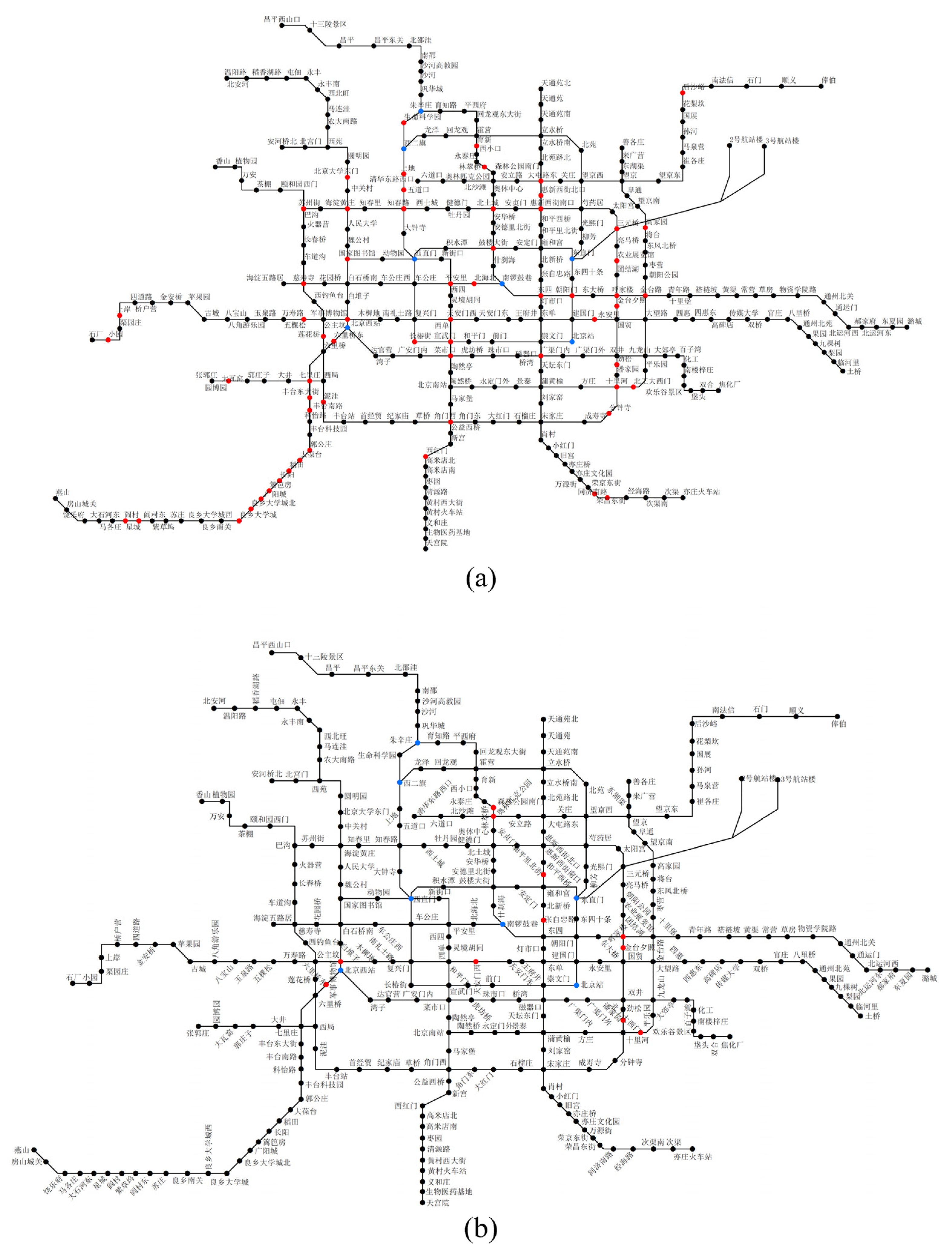
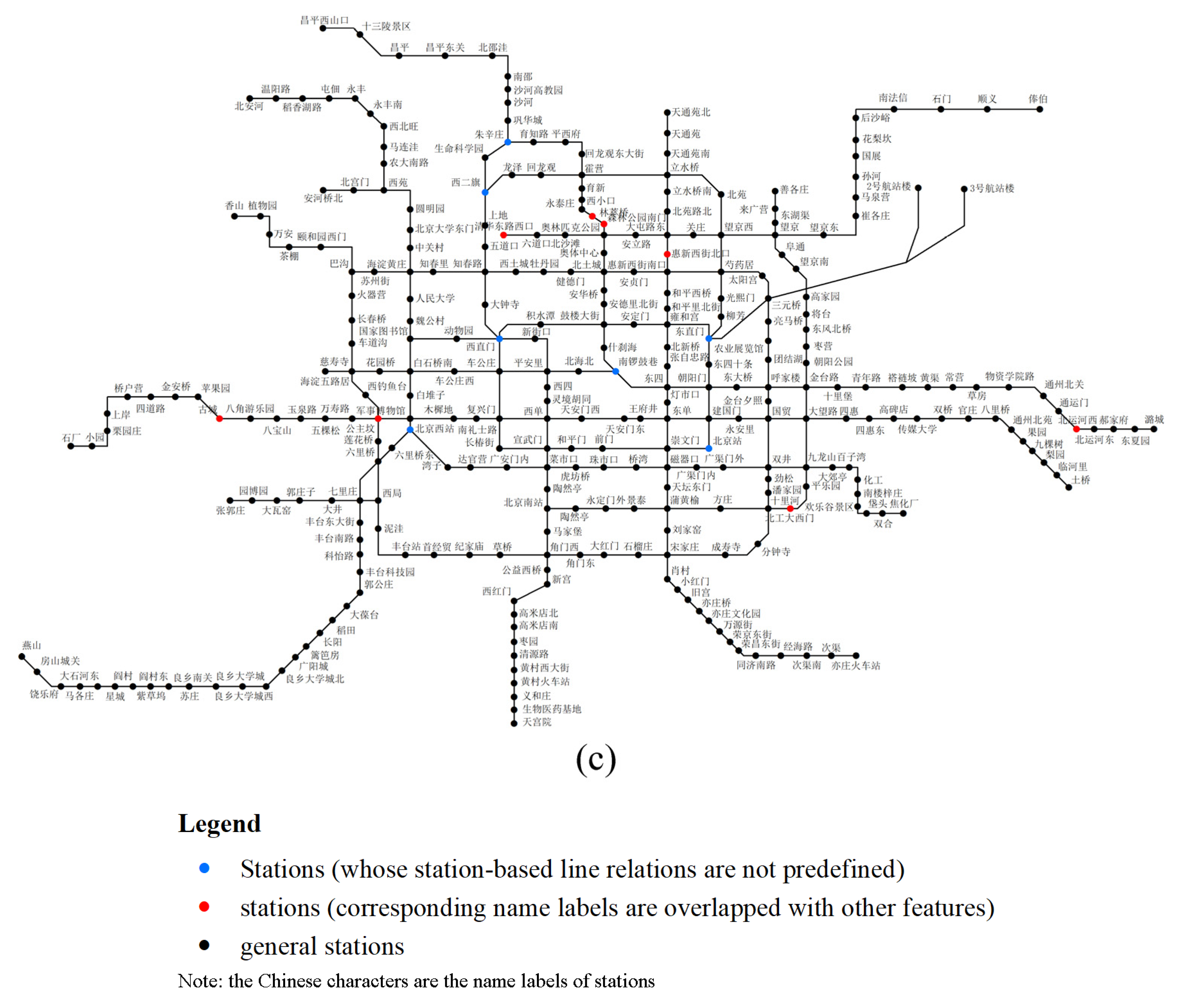
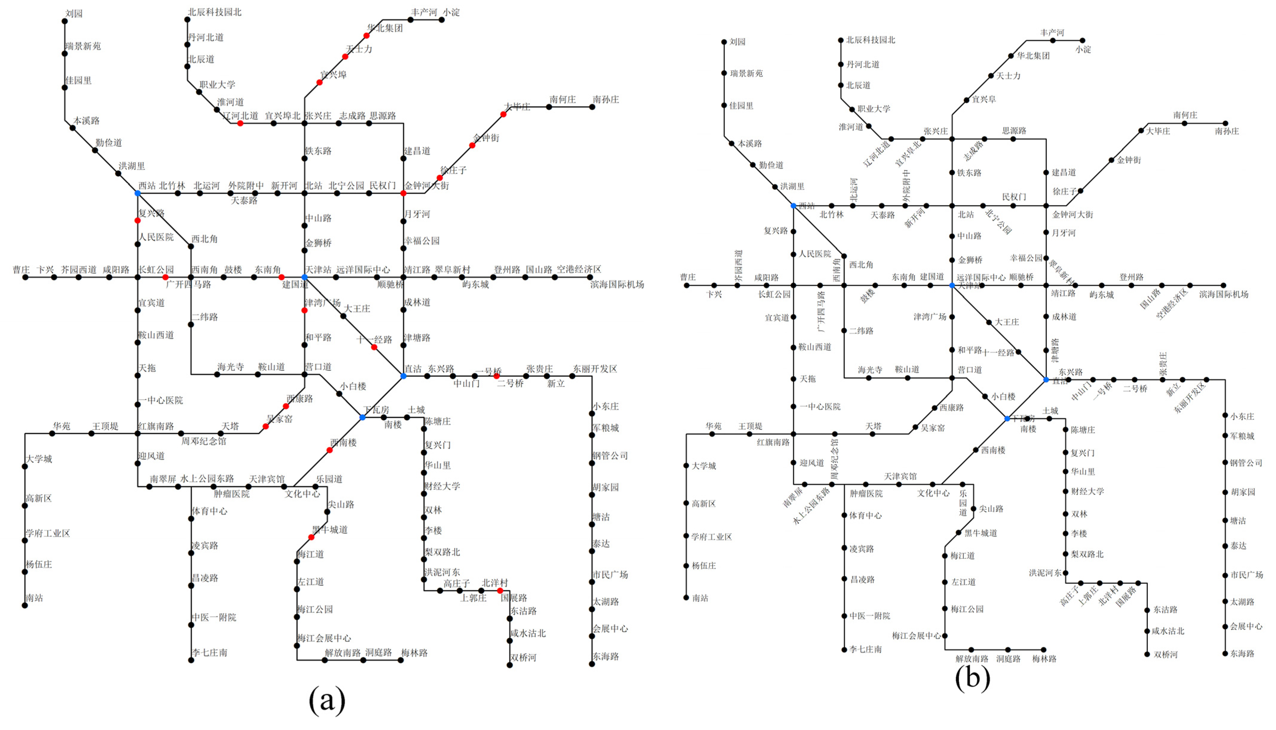
| Metro Name | Number of Stations | Number of Stations Whose Station-Based Line Relations Are Not Predefined | Labelling Method | Total Number of Overlaps | Number of Overlaps in the Stations Whose Station-Based Line Relations Are Not Predefined |
|---|---|---|---|---|---|
| Beijing | 316 | 7 | Maplex | 67 | 4 |
| DS | 13 | 2 | |||
| ANNs | 8 | 0 | |||
| Tianjin | 150 | 4 | Maplex | 20 | 1 |
| DS | 4 | 4 | |||
| ANNs | 0 | 0 | |||
| Hong Kong | 93 | 1 | Maplex | 10 | 0 |
| DS | 0 | 0 | |||
| ANNs | 0 | 0 |
| Metro | Questionnaire | Paired t-Test | |||
|---|---|---|---|---|---|
| Labelling Method | Average Score | Comparison Objects | p-Value | The Difference Is Significant? | |
| Beijing | Maplex | 3.65 | ANNs vs. Maplex | 0.008 | Yes |
| DS | 3.71 | ANNs vs. DS | 0.075 | No | |
| ANNs | 3.84 | Maplex vs. DS | 0.519 | No | |
| Tianjin | Maplex | 3.68 | ANNs vs. Maplex | 0.001 | Yes |
| DS | 3.76 | ANNs vs. DS | 0.021 | Yes | |
| ANNs | 3.94 | Maplex vs. DS | 0.353 | No | |
| Hong Kong | Maplex | 3.84 | ANNs vs. Maplex | 0.145 | No |
| DS | 3.84 | ANNs vs. DS | 0.139 | No | |
| ANNs | 3.95 | Maplex vs. DS | 1 | No | |
Publisher’s Note: MDPI stays neutral with regard to jurisdictional claims in published maps and institutional affiliations. |
© 2022 by the authors. Licensee MDPI, Basel, Switzerland. This article is an open access article distributed under the terms and conditions of the Creative Commons Attribution (CC BY) license (https://creativecommons.org/licenses/by/4.0/).
Share and Cite
Lan, T.; Li, Z.; Wang, J.; Gong, C.; Ti, P. An ANNs-Based Method for Automated Labelling of Schematic Metro Maps. ISPRS Int. J. Geo-Inf. 2022, 11, 36. https://doi.org/10.3390/ijgi11010036
Lan T, Li Z, Wang J, Gong C, Ti P. An ANNs-Based Method for Automated Labelling of Schematic Metro Maps. ISPRS International Journal of Geo-Information. 2022; 11(1):36. https://doi.org/10.3390/ijgi11010036
Chicago/Turabian StyleLan, Tian, Zhilin Li, Jicheng Wang, Chengyin Gong, and Peng Ti. 2022. "An ANNs-Based Method for Automated Labelling of Schematic Metro Maps" ISPRS International Journal of Geo-Information 11, no. 1: 36. https://doi.org/10.3390/ijgi11010036
APA StyleLan, T., Li, Z., Wang, J., Gong, C., & Ti, P. (2022). An ANNs-Based Method for Automated Labelling of Schematic Metro Maps. ISPRS International Journal of Geo-Information, 11(1), 36. https://doi.org/10.3390/ijgi11010036