
Land-Use Suitability Assessment Using Delphi and Analytical Hierarchy Process (D-AHP) Hybrid Model for Coastal City Management: Kuala Terengganu, Peninsular Malaysia

 ,
,  ,
, 
Abstract
:1. Introduction
2. Materials and Methods
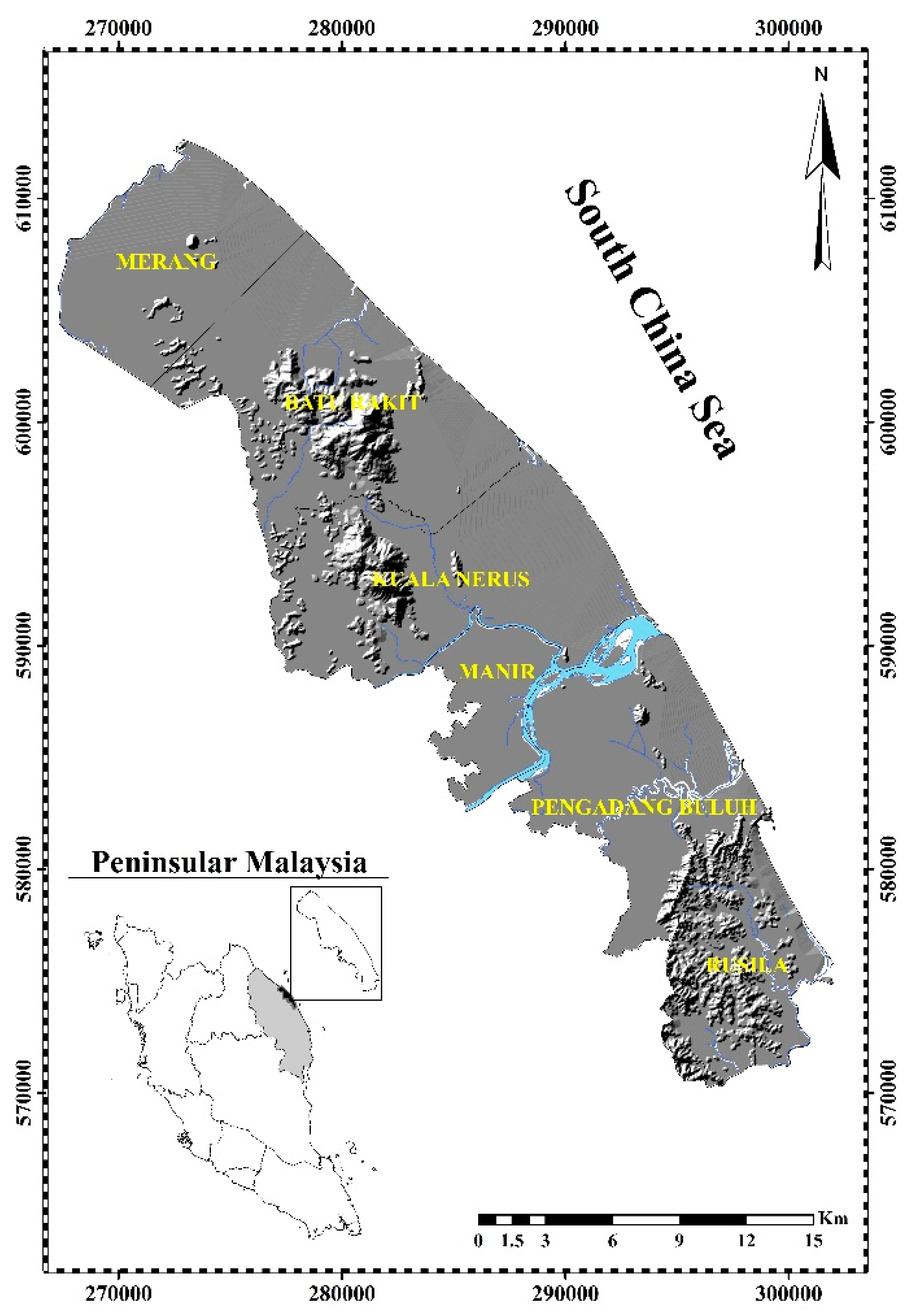
2.1. Study Area
2.2. Data Used
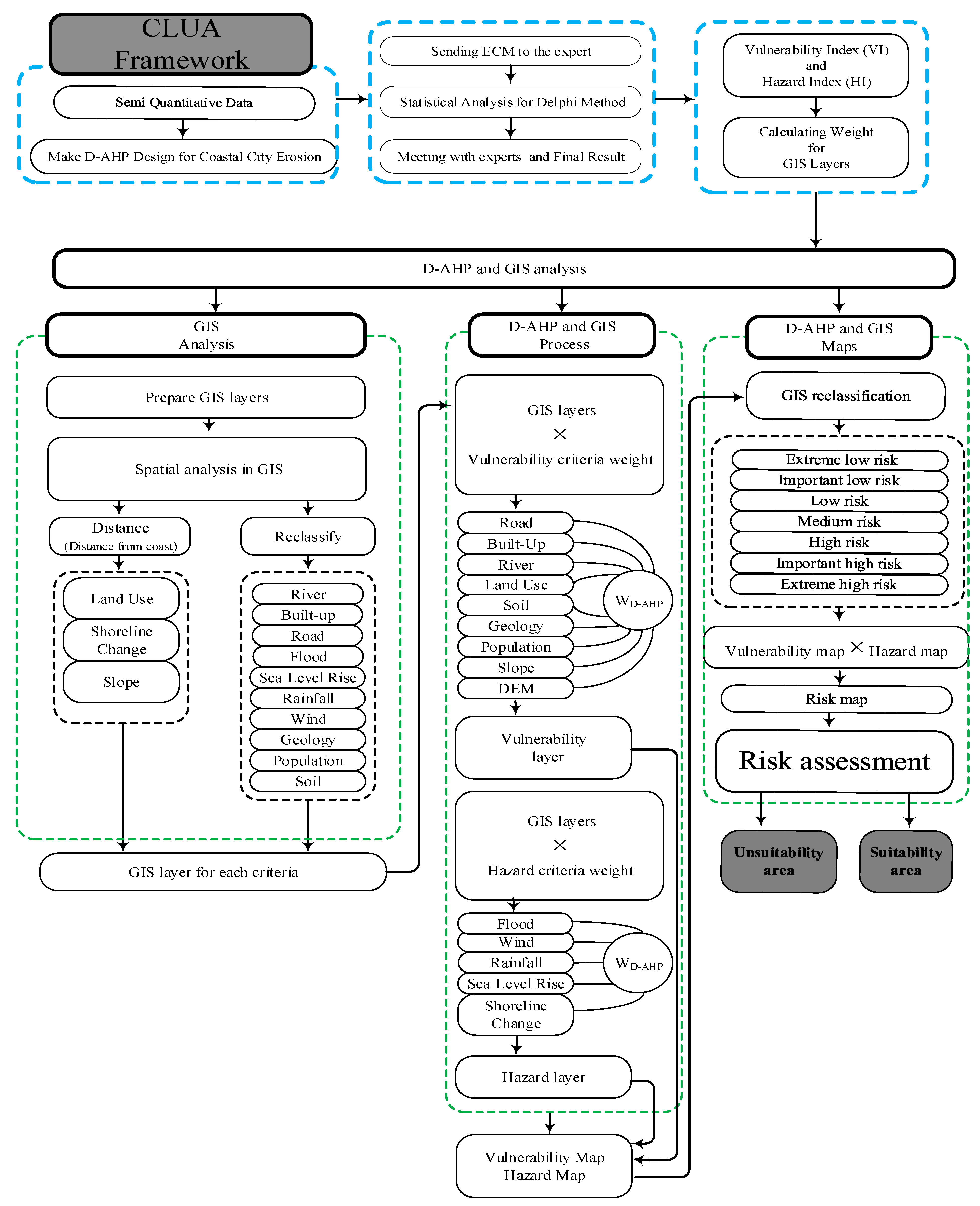
2.3. CLUA Model Framework
3. Results
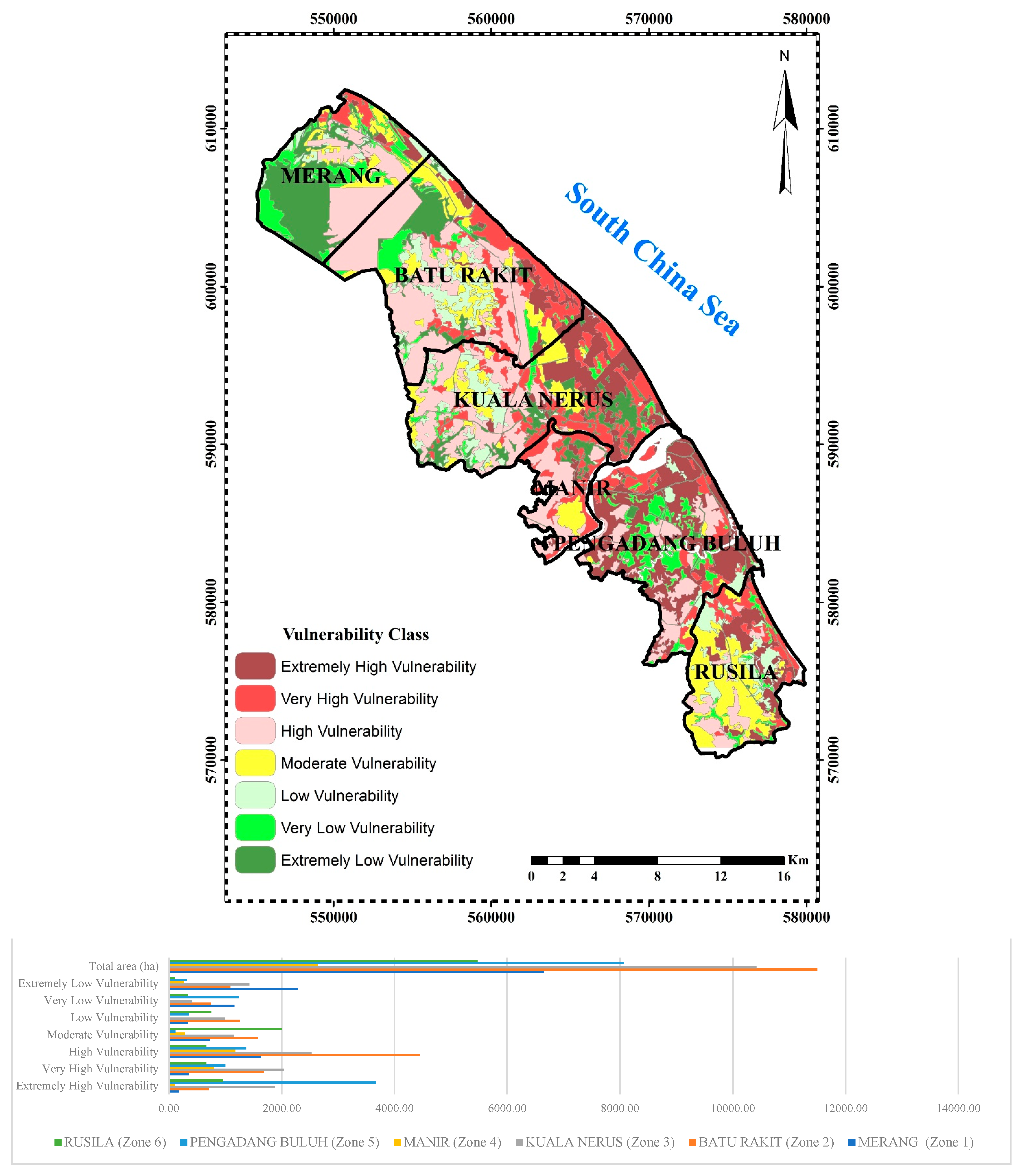
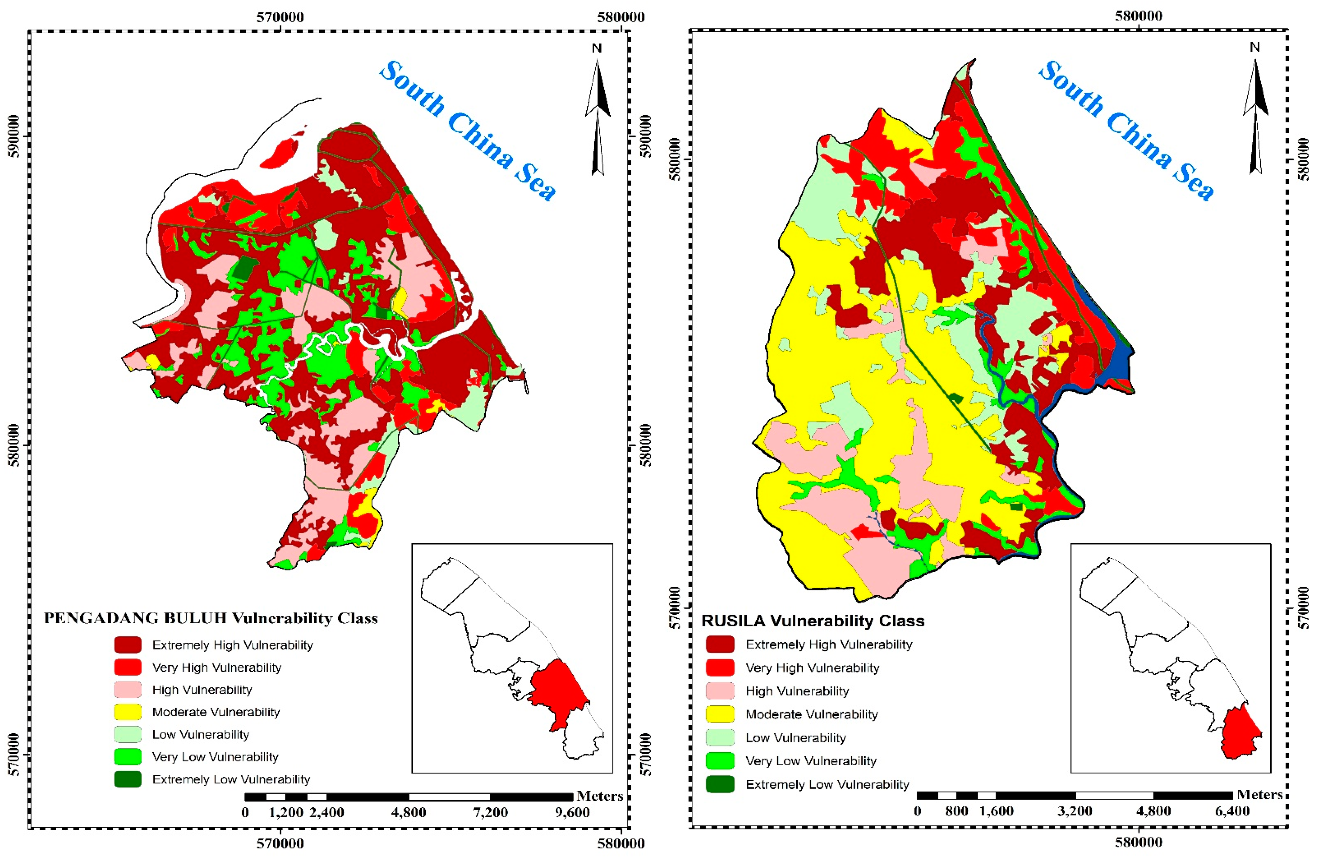
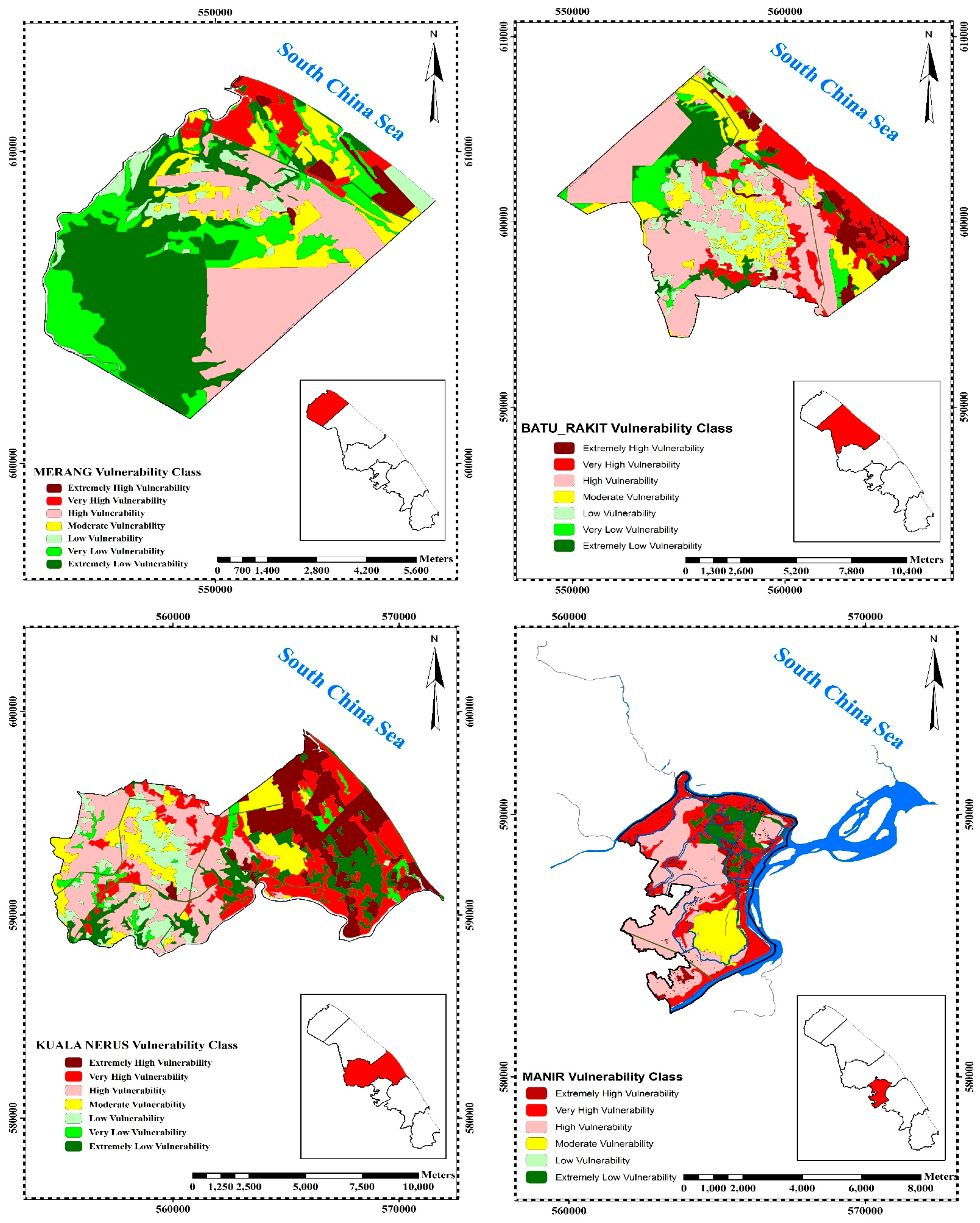
3.1. Analysis of Vulnerability Maps on the Local Scale
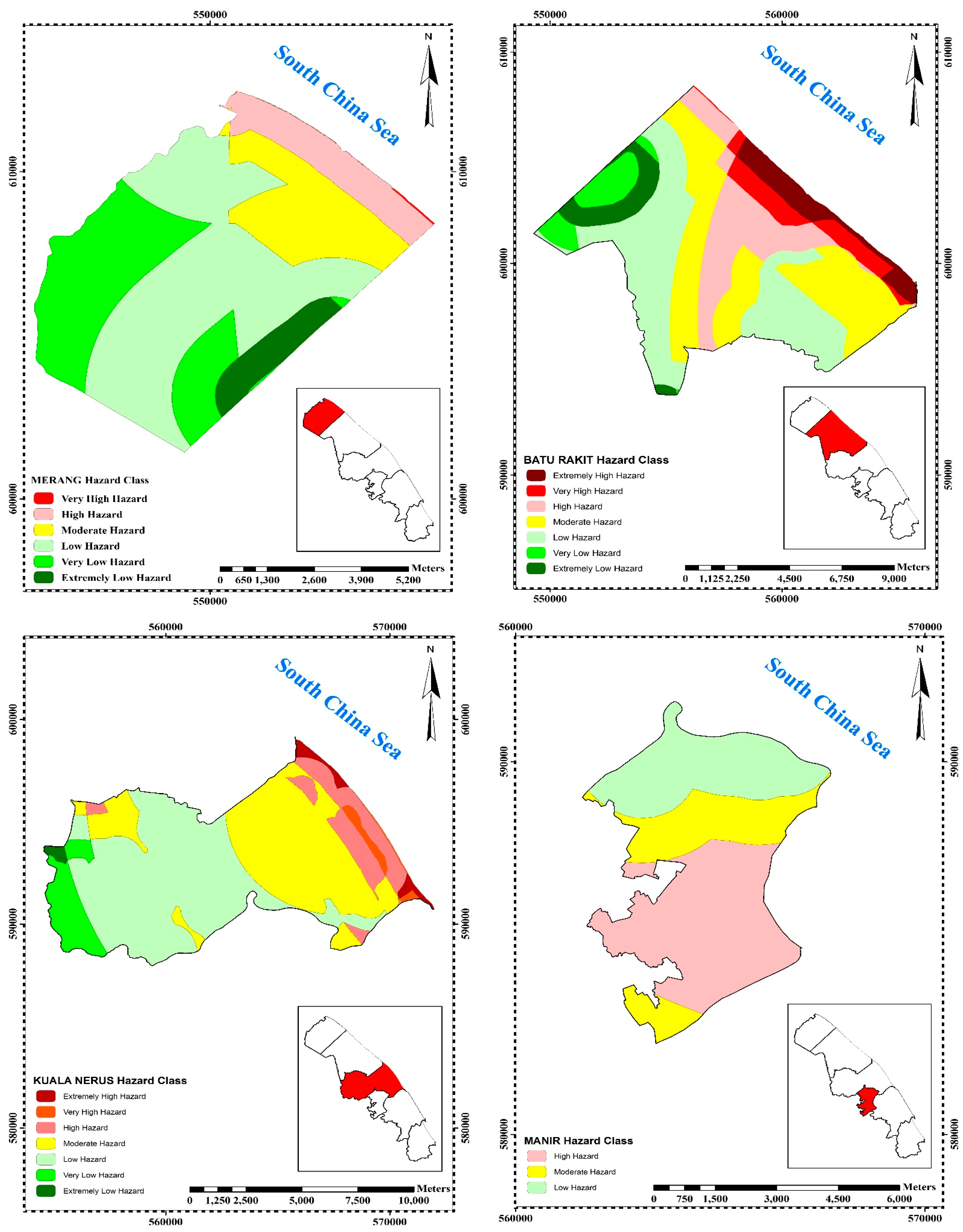
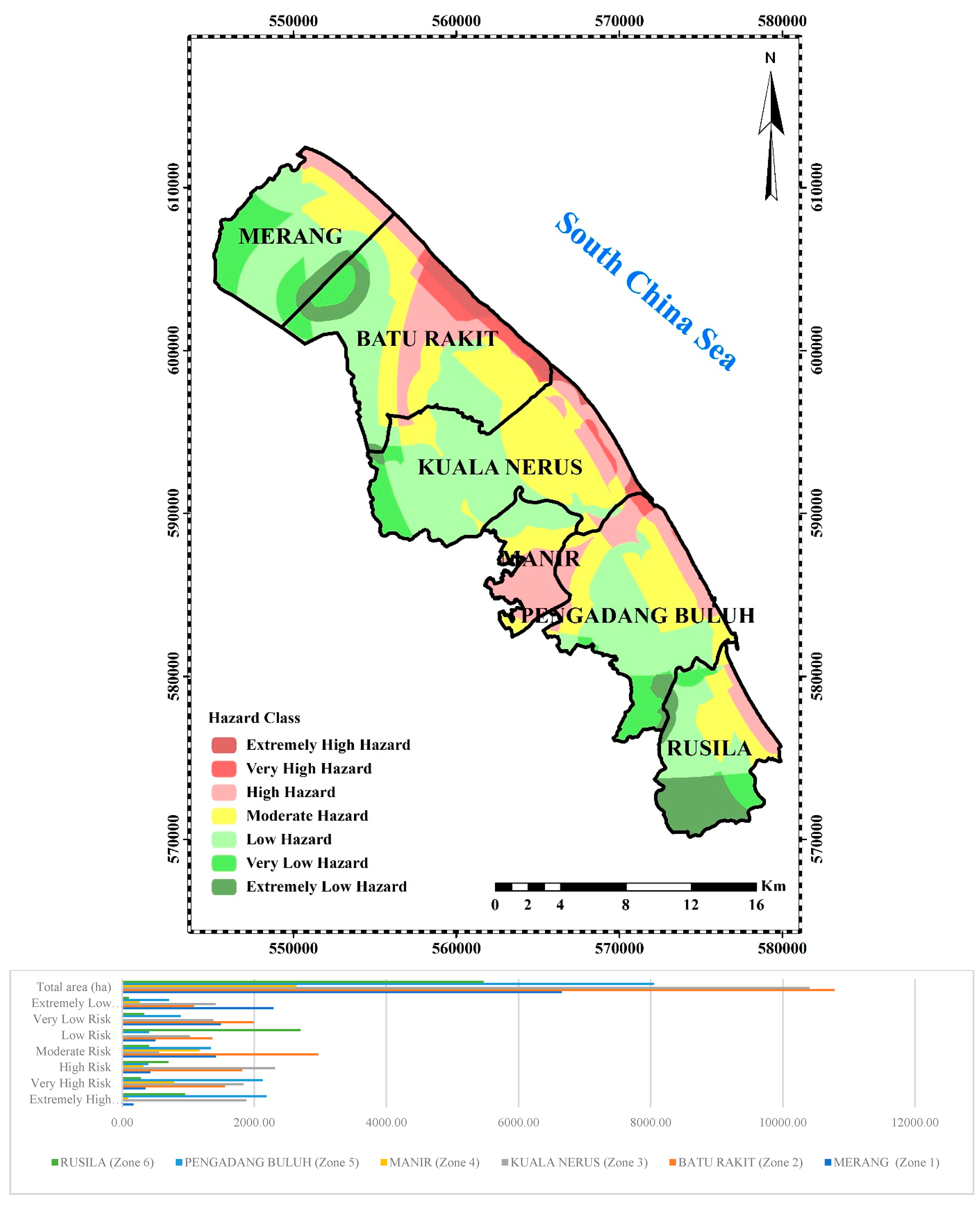
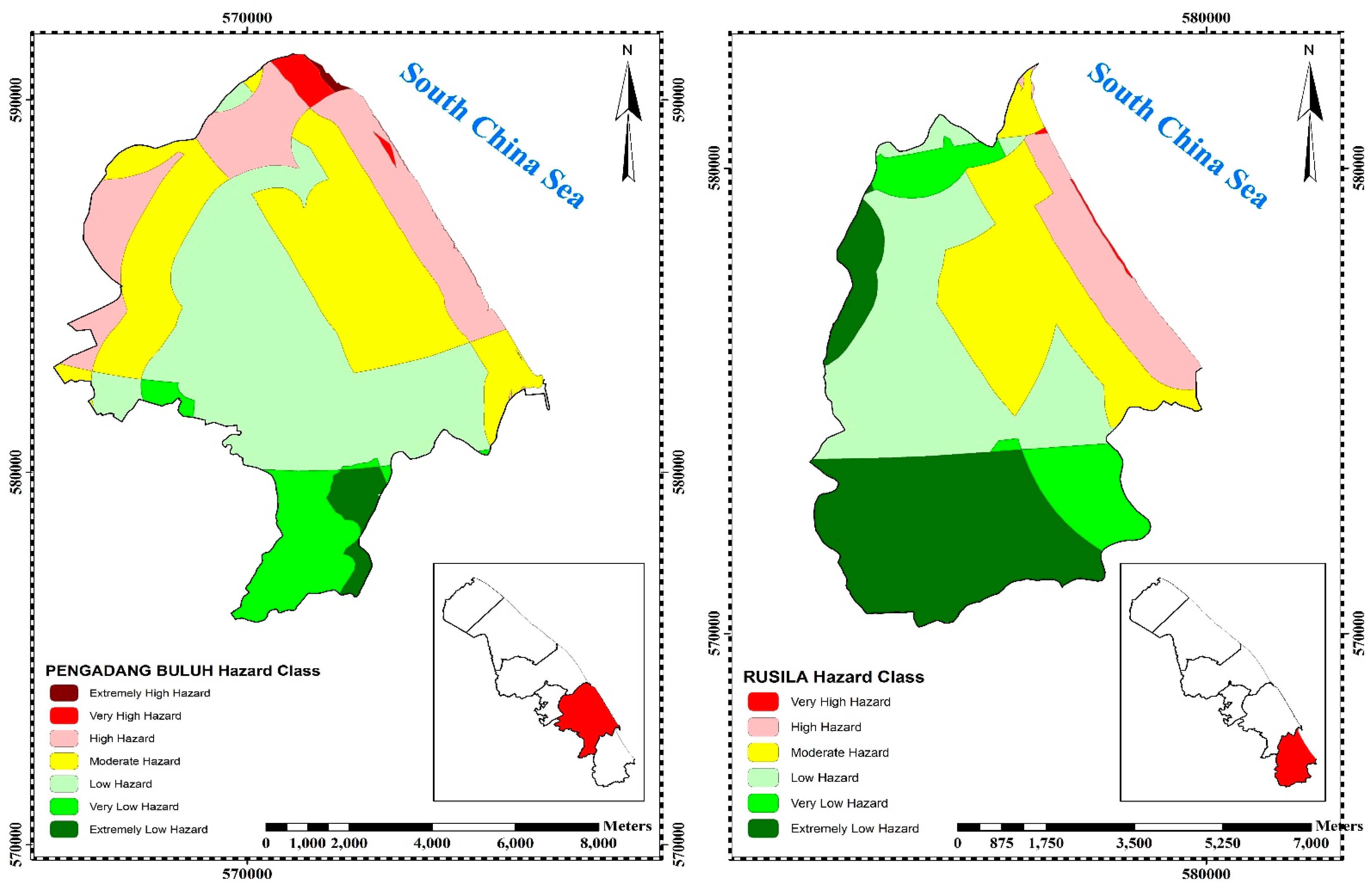
3.2. Analysis of Hazard Maps on a Local Scale
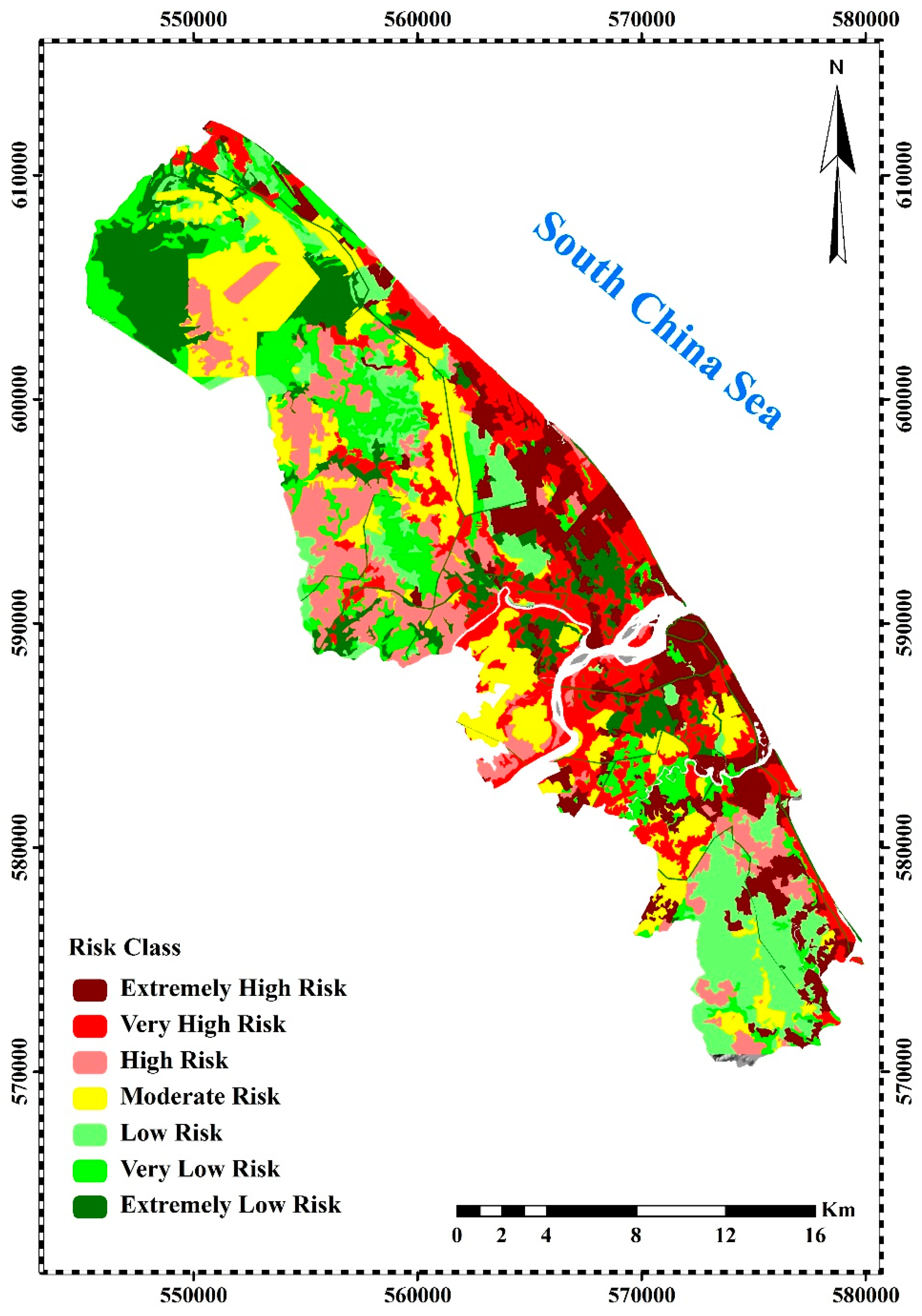
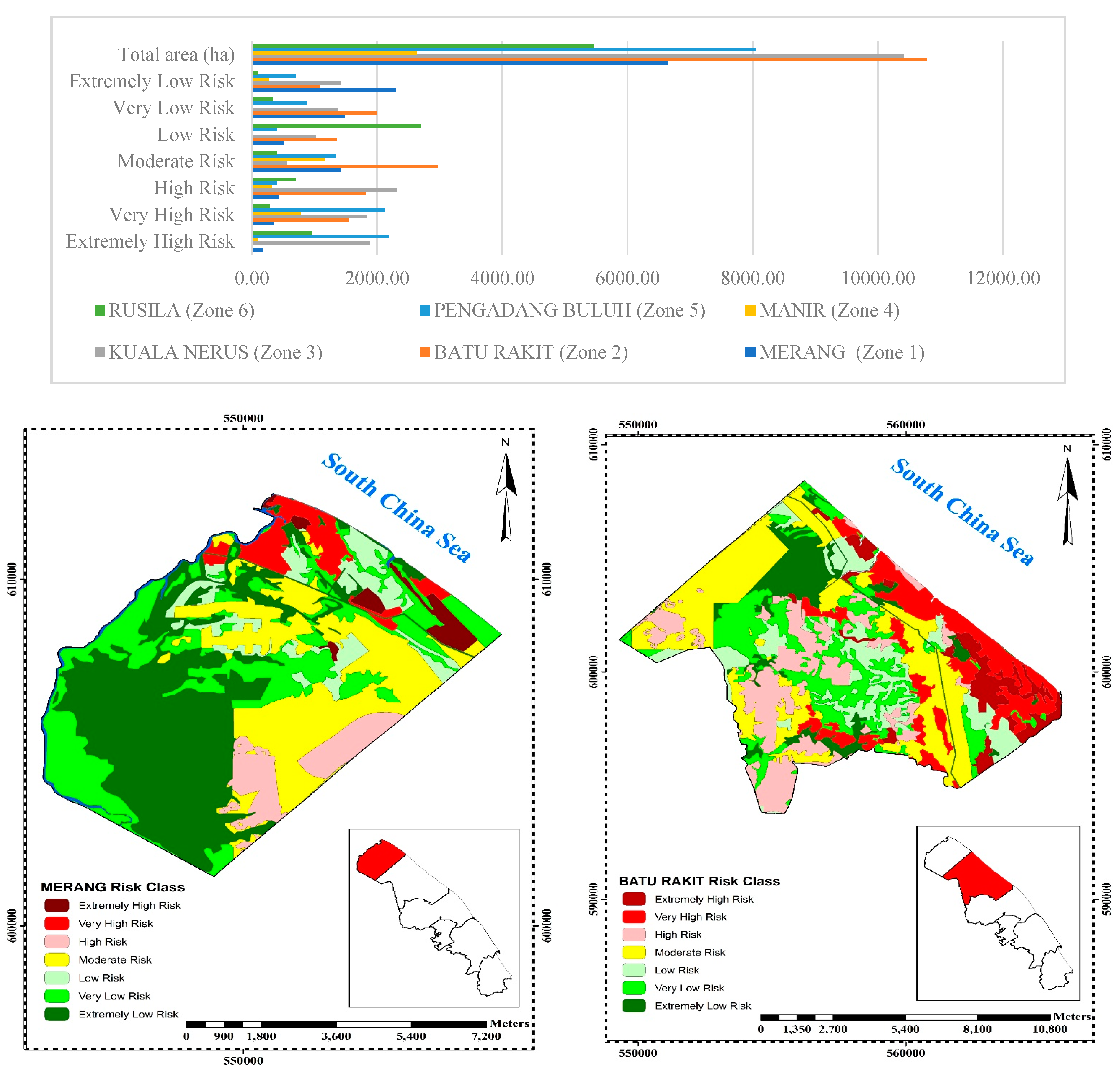
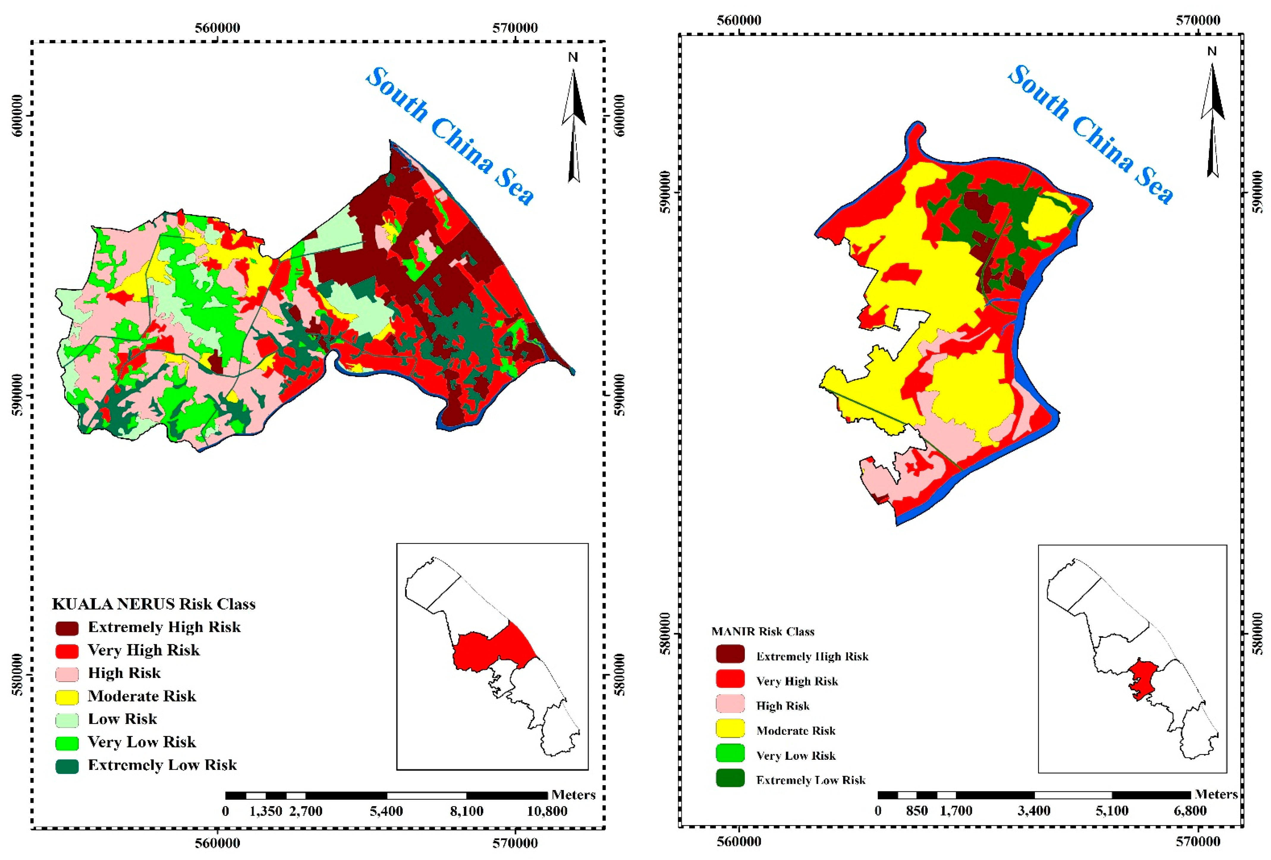
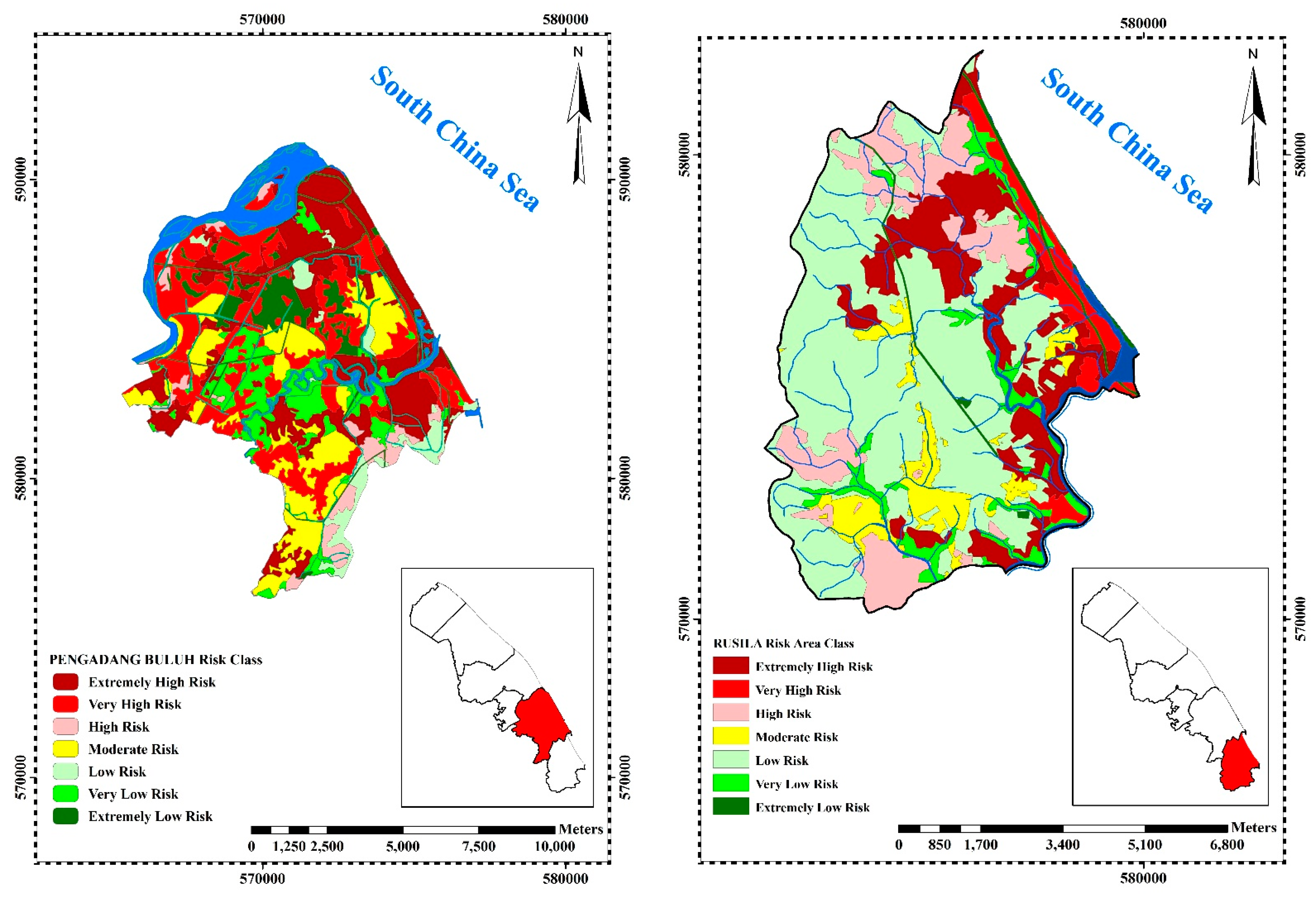
3.3. Coastal City Erosion Risk Assessment Maps on the Local Scale
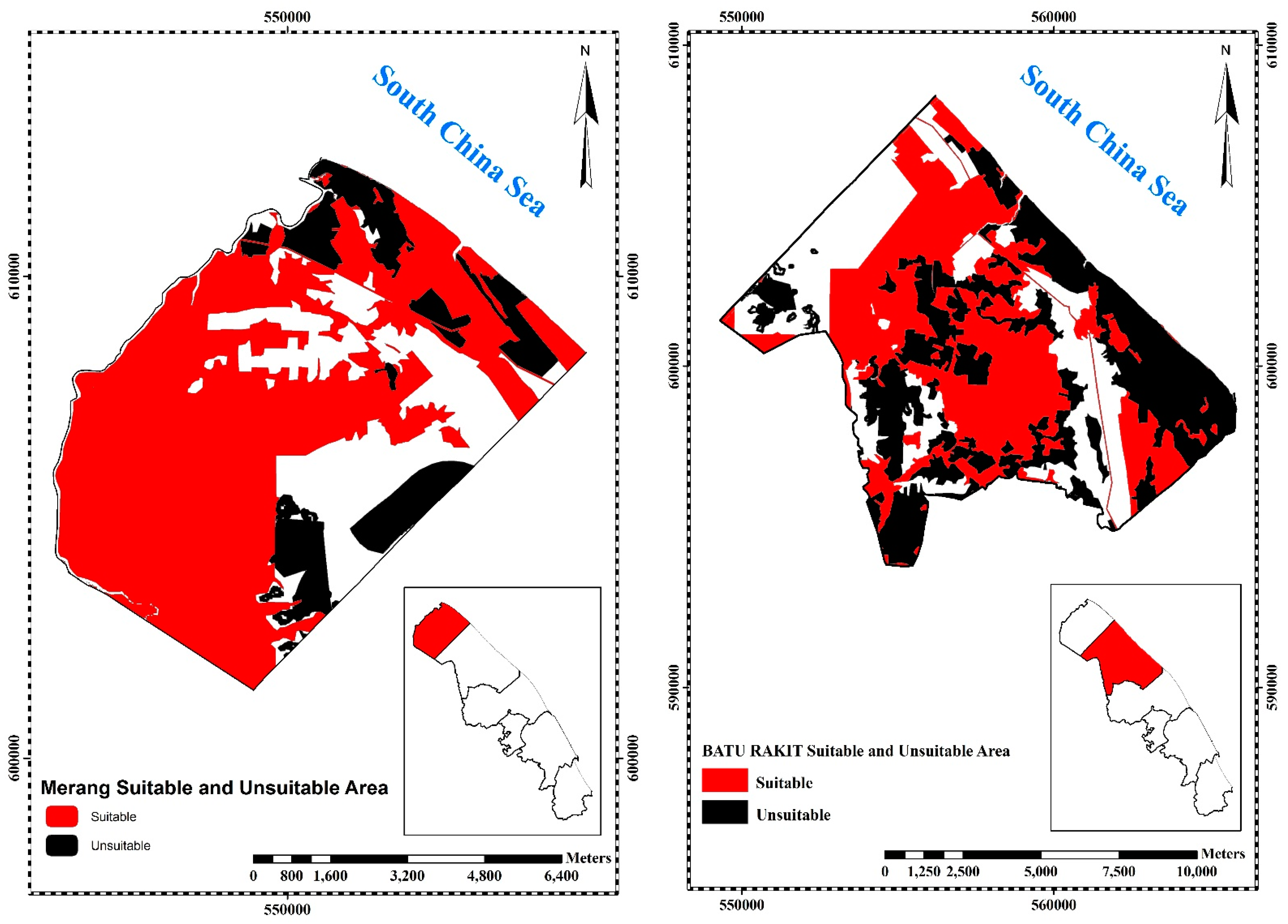
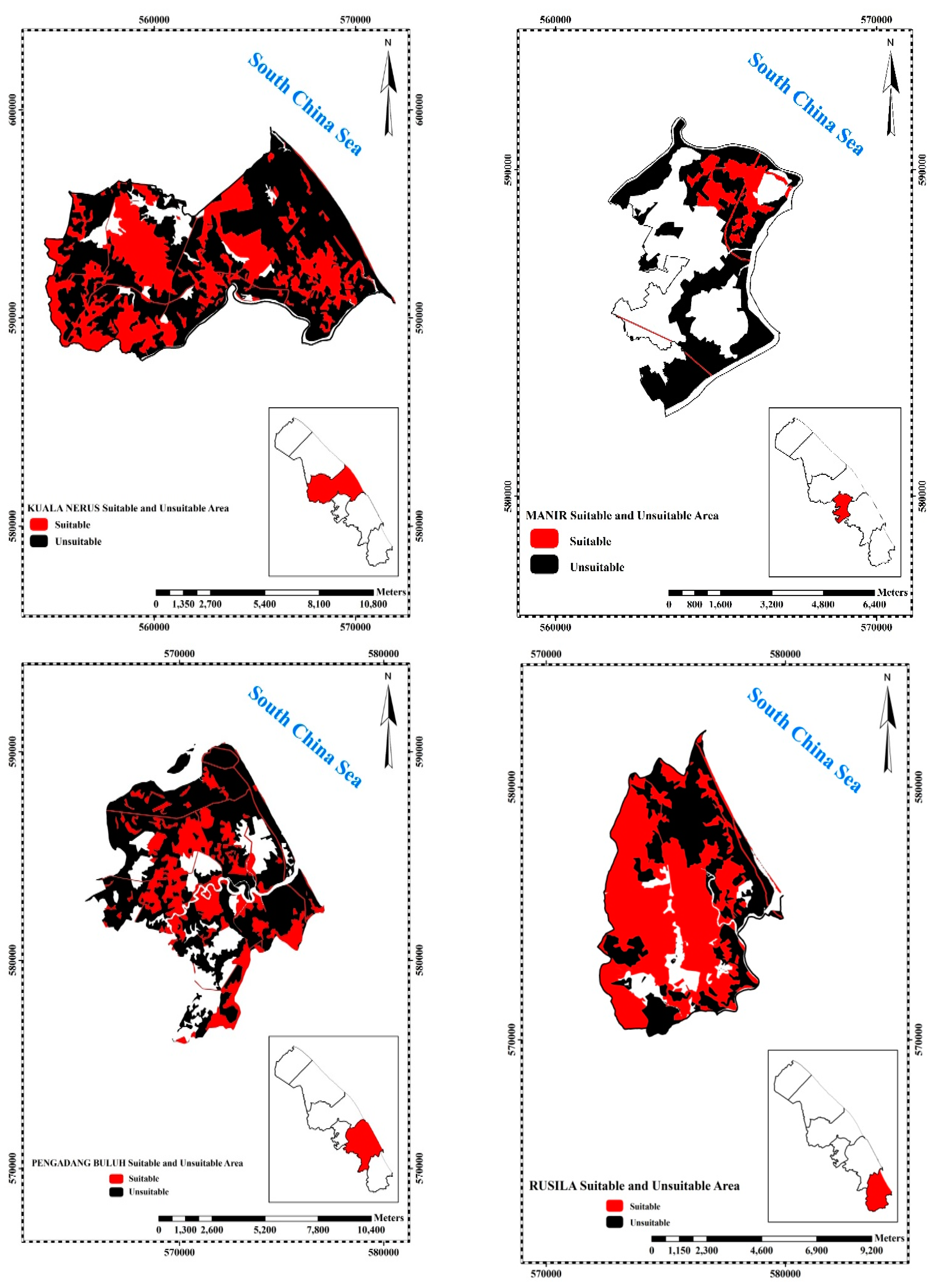
3.4. Assessment of Land-Use Suitability Area
4. Discussion
5. Conclusions
Author Contributions
Funding
Institutional Review Board Statement
Informed Consent Statement
Data Availability Statement
Acknowledgments
Conflicts of Interest
References
- Rabati, A.P.; Jafarzadeh, A.A.; Shahbazi, F.; Rezapour, S.; Momtaz, H.R. Qualitative and quantitative land-suitability evalua-tion for sunflower and maize in the north-west of Iran. Arch. Agron. Soil Sci. 2012, 58, 1229–1242. [Google Scholar] [CrossRef]
- Taghizadeh-Mehrjardi, R.; Nabiollahi, K.; Rasoli, L.; Kerry, R.; Scholten, T. Land Suitability Assessment and Agricultural Production Sustainability Using Machine Learning Models. Agronomy 2020, 10, 573. [Google Scholar] [CrossRef]
- De Wrachien, D. Land use planning: A key to sustainable agriculture. In Conservation Agriculture; Springer: Dordrecht, The Netherlands, 2003; pp. 471–483. [Google Scholar]
- Azadi, H.; Barati, A.A.; Mohajeri, F.; Passel, S.V.; Witlox, F. Land-use suitability in Northeast Iran: Application of AHP-GIS hybrid model. ISPRS Int. J. Geo-Inf. 2017, 6, 396. [Google Scholar]
- Mason, P. Tourism Impacts, Planning and Management; Routledge: Oxfordshire, UK, 2020. [Google Scholar]
- Thompson, R.; Crowe, T.P.; Hawkins, S.J. Rocky intertidal communities: Past environmental changes, present status and predictions for the next 25 years. Environ. Conserv. 2002, 29, 168–191. [Google Scholar] [CrossRef]
- Łabuz, T.A. Environmental Impacts—Coastal Erosion and Coastline Changes. In North Sea Region Climate Change Assessment; Springer Science and Business Media LLC: Berlin, Germany, 2015; pp. 381–396. [Google Scholar]
- Mitasova, H.; Overton, M.F.; Recalde, J.J.; Bernstein, D.J.; Freeman, C.W. Raster-Based Analysis of Coastal Terrain Dynamics from Multitemporal Lidar Data. J. Coast. Res. 2009, 252, 507–514. [Google Scholar] [CrossRef]
- Kolednik, D. Coastal monitoring for change detection using multi-temporal LiDAR data. In Proceedings of the CESCG 2014: The 18th Central European Seminar on Computer Graphics, Smolenice, Slovakia, 25–27 May 2014; pp. 73–78. [Google Scholar]
- Chee, S.Y.; Othman, A.G.; Sim, Y.K.; Adam, A.N.M.; Firth, L. Land reclamation and artificial islands: Walking the tightrope between development and conservation. Glob. Ecol. Conserv. 2017, 12, 80–95. [Google Scholar] [CrossRef] [Green Version]
- Wang, G.; Liu, Y.; Wang, H.; Wang, X. A comprehensive risk analysis of coastal zones in China. Estuarine, Coast. Shelf. Sci. 2014, 140, 22–31. [Google Scholar] [CrossRef]
- Agrawala, S.; Ota, T.; Ahmed, A.U.; Smith, J.; Van Aalst, M. Development and Climate Change in Bangladesh: Focus on Coastal Flooding and the Sundarbans; OECD: Paris, UK, 2003; pp. 1–49. [Google Scholar]
- Bock, M.; Gasser, P.-Y.; Pettapiece, W.W.; Brierley, A.J.; Bootsma, A.; Schut, P.; Neilsen, D.; Smith, C.A.S. The Land Suitability Rating System Is a Spatial Planning Tool to Assess Crop Suitability in Canada. Front. Environ. Sci. 2018, 6, 77. [Google Scholar] [CrossRef]
- AbdelRahman, M.A.; Natarajan, A.; Hegde, R. Assessment of land suitability and capability by integrating remote sens-ing and GIS for agriculture in Chamarajanagar district, Karnataka, India. Egypt. J. Remote. Sens. Space Sci. 2016, 19, 125–141. [Google Scholar]
- Das, A.; Lee, M.W.V.; Wong, Y.H.I.; Tang, Y.T.K.; Aziz, S. GIS Based Multi-Criteria Land Suitability Assessment for Future Urban Development in The Country Park Peripheries of Hong Kong, Lantu North Country Park & Extension. Preprints 2021. [Google Scholar] [CrossRef]
- Shi, P. Hazards, Disasters, and Risks. In IHDP/Future Earth-Integrated Risk Governance Project Series; Springer Science and Business Media LLC: Berlin, Germany, 2019; pp. 1–48. [Google Scholar]
- Thomas, K.; Hardy, R.D.; Lazrus, H.; Mendez, M.; Orlove, B.; Rivera-Collazo, I.; Winthrop, R. Explaining differential vulnera-bility to climate change: A social science review. Wiley Interdiscip. Rev. Clim. Chang. 2019, 10, e565. [Google Scholar] [CrossRef] [Green Version]
- Paul, S.K. Vulnerability Concepts and its Application in Various Fields: A Review on Geographical Perspective. J. Life Earth Sci. 2014, 8, 63–81. [Google Scholar] [CrossRef]
- Neumann, B.; Vafeidis, A.T.; Zimmermann, J.; Nicholls, R.J. Future coastal population growth and exposure to sea-level rise and coastal flooding—A global assessment. PLoS ONE 2015, 10, e0118571. [Google Scholar]
- IPCC. Climate Change 2014: Synthesis Report. In Contribution of Working Groups I, II and III to the Fifth Assessment Report of the Intergovernmental Panel on Climate Change; Core Writing Team; Pachauri, R.K., Meyer, L.A., Eds.; IPCC: Geneva, Switzerland, 2014; p. 151. [Google Scholar]
- IPCC. Summary for Policymakers. In Climate Change 2021: The Physical Science Basis. Contribution of Working Group I to the Sixth Assessment Report of the Intergovernmental Panel on Climate Change; Masson-Delmotte, V.P., Zhai, A., Pirani, S.L., Connors, C., Péan, S., Berger, N., Caud, Y., Chen, L., Goldfarb, M.I., Gomis, M., Eds.; Cambridge University Press: Cambridge, UK, 2021; 65p. [Google Scholar]
- Zou, Y.; Xu, J.; Zhang, R. Rethinking vulnerability and human behaviour in arid and semi-arid regions in northwestern China. Environ. Monit. Assess. 2020, 192, 1–20. [Google Scholar] [CrossRef] [PubMed]
- Mimura, N. Sea-level rise caused by climate change and its implications for society. Proc. Jpn. Acad. Ser. B 2013, 89, 281–301. [Google Scholar] [CrossRef] [PubMed] [Green Version]
- McLean, R.F.; Tsyban, A.; Burkett, V.; Codignotto, J.O.; Forbes, D.L.; Mimura, N.; Ittekkot, V. Coastal Zones and Marine Ecosystems; Intergovernmental Panel on Climate Change: Geneva, Switzerland, 2001; pp. 343–379. [Google Scholar]
- Wu, Q.; Liu, Y.; Liu, D.; Zhou, W. Prediction of Floor Water Inrush: The Application of GIS-Based AHP Vulnerable Index Method to Donghuantuo Coal Mine, China. Rock Mech. Rock Eng. 2011, 44, 591–600. [Google Scholar] [CrossRef]
- Nicholls, R.J.; Cazenave, A. Sea-Level Rise and Its Impact on Coastal Zones. Science 2010, 328, 1517–1520. [Google Scholar] [CrossRef]
- Curran, S.R. Migration, social capital and the environment: Considering Migrant Selectivity and Networks in Relation to Coastal Ecosystems. In Population and Environment: Methods of Analysis; Lutz, W., Prskawetz, A., Sanderson, W., Eds.; Population Council: New York, NY, USA, 2002; p. 252. [Google Scholar]
- Woodworth, P.L.; Melet, A.; Marcos, M.; Ray, R.D.; Wöppelmann, G.; Sasaki, Y.N.; Cirano, M.; Hibbert, A.; Huthnance, J.M.; Monserrat, S.; et al. Forcing Factors Affecting Sea Level Changes at the Coast. Surv. Geophys. 2019, 40, 1351–1397. [Google Scholar] [CrossRef] [Green Version]
- Raj, J.; Yusoff, I.; Abdullah, W.H. Past and present-day coastal changes between Kuala Sungai Besar and Kuala Besar, Kelantan Darul Naim. Bull. Geol. Soc. Malays. 2007, 53, 15–20. [Google Scholar] [CrossRef]
- Kok, P.H.; Akhir, M.F.; Qiao, F. Distinctive characteristics of upwelling along the Peninsular Malaysia’s east coast during 2009/10 and 2015/16 El Niños. Cont. Shelf Res. 2019, 184, 10–20. [Google Scholar] [CrossRef]
- NAHRIM. The Study of the Impact of Climate Change on Sea Level Rise in Malaysia (Final Report); National Hydraulic Research Institute Malaysia: Seri Kembangan, Selangor, Malaysia, 2010; 172p. [Google Scholar]
- NAHRIM. Proceedings of the National Seminar on Coastal Morphology (COSMO) the Muddy Coast of Malaysia (Final Report), 14 December 2010; Coastal Research Centre, National Hydraulic Research Institute Malaysia (NAHRIM): Seri Kembangan, Selangor, Malaysia, 2010; 220p. [Google Scholar]
- Yanalagaran, R.; Ramli, N.I. Assessment of Coastal Erosion Related to Wind Characteristics in Peninsular Malaysia. J. Eng. Sci. Technol. 2018, 13, 3677–3690. [Google Scholar]
- Chalabi, A.; Mohd-Lokman, H.; Mohd-Suffian, I.; Karamali, K.; Karthigeyan, V.; Masita, M. Monitoring shoreline change using IKONOS image and aerial photographs: A case study of Kuala Terengganu area, Malaysia. In Proceedings of the ISPRS Commission VII Mid-Term Symposium “Remote Sensing: From Pixels to Processes”, Enschede, The Netherlands, 6 December 2006; pp. 8–11. [Google Scholar]
- Xue, Z.; Feng, A.; Yin, P.; Xia, D. Coastal Erosion Induced by Human Activities: A Northwest Bohai Sea Case Study. J. Coast. Res. 2009, 253, 723–733. [Google Scholar] [CrossRef]
- Møller, J.; Pettitt, A.N.; Reeves, R.; Berthelsen, K.K. An efficient Markov chain Monte Carlo method for distributions with intractable normalising constants. Biometrika 2006, 93, 451–458. [Google Scholar] [CrossRef] [Green Version]
- Ballesteros, C.; Jiménez, J.A.; Valdemoro, H.I.; Bosom, E. Erosion consequences on beach functions along the Maresme coast (NW Mediterranean, Spain). Nat. Hazards 2017, 90, 173–195. [Google Scholar] [CrossRef] [Green Version]
- Liew, M.; Xiao, M.; Jones, B.M.; Farquharson, L.M.; Romanovsky, V. Prevention and control measures for coastal erosion in northern high-latitude communities: A systematic review based on Alaskan case studies. Environ. Res. Lett. 2020, 15, 093002. [Google Scholar] [CrossRef]
- Fuchs, S.; Birkmann, J.; Glade, T. Vulnerability assessment in natural hazard and risk analysis: Current approaches and future challenges. Nat. Hazards 2012, 64, 1969–1975. [Google Scholar] [CrossRef] [Green Version]
- Aven, T. Risk assessment and risk management: Review of recent advances on their foundation. Eur. J. Oper. Res. 2016, 253, 1–13. [Google Scholar] [CrossRef] [Green Version]
- Liu, X.-P.; Zhang, J.-Q.; Tong, Z.-J.; Bao, Y. GIS-based multi-dimensional risk assessment of the grassland fire in northern China. Nat. Hazards 2012, 64, 381–395. [Google Scholar] [CrossRef]
- Bagheri, M.; Sulaiman, W.; Vaghefi, N. Land Use Suitability Analysis Using Multi Criteria Decision Analysis Method for Coastal Management and Planning: A Case Study of Malaysia. J. Environ. Sci. Technol. 2012, 5, 364–372. [Google Scholar] [CrossRef] [Green Version]
- Everest, T.İ.M.U.Ç.İ.N.; Sungur, A.; Özcan, H. Determination of agricultural land suitability with a multiple-criteria deci-sion-making method in Northwestern Turkey. Int. J. Environ. Sci. Technol. 2020, 18, 1–16. [Google Scholar]
- Bagheri, M.; Sulaiman, W.N.A.; Vaghefi, N. Application of geographic information system technique and analytical hier-archy process model for land-use suitability analysis on coastal area. J. Coast. Conserv. 2013, 17, 1–10. [Google Scholar] [CrossRef] [Green Version]
- Mensah, J. Sustainable development: Meaning, history, principles, pillars, and implications for human action: Literature review. Cogent Soc. Sci. 2019, 5, 1653531. [Google Scholar] [CrossRef]
- Ariffin, B.; Helmy, E. Effect of Monsoons on Beach Morphodynamics in the East Coast of Peninsular Malaysia: Examples from Kuala Terengganu Coast. Ph.D. Dissertation, Universiti Malaysia Terengganu, Kuala Terengganu, Malaysia, 2017. [Google Scholar]
- Eleventh Malaysian Plan. The Economic Planning Unit Prime Minister’s Department, Putrajaya. 2015. Available online: http://rmk11.epu.gov.my/book/eng/Elevent-Malaysia-Plan/RMKe-11%20Book.pdf (accessed on 1 July 2021).
- Bagheri, M.; Ibrahim, Z.Z.; Bin Mansor, S.; Manaf, L.A.; Badarulzaman, N.; Vaghefi, N. Shoreline change analysis and erosion prediction using historical data of Kuala Terengganu, Malaysia. Environ. Earth Sci. 2019, 78, 1–21. [Google Scholar] [CrossRef]
- Salim, J.M.; Radzi, M.A.; Razali, S.M.; Cooke, F.M. Coastal Landscapes of Peninsular Malaysia: The Changes and Implica-tions for Their Resilience and Ecosystem Services. In Landscape Reclamation-Rising from What’s Left; Intech Open: London, UK, 2018. [Google Scholar]
- Bhuiyan, M.A.H.; Siwar, C. Tourism for Economic Development in East Coast Economic Region (ECER), Bangi, Selangor, Malaysia; Institute for Enviroment and Development, University Kebangsaan Malaysia: Bangi, Malaysia, 2011. [Google Scholar]
- Aziz, Z.A.; Yaacob, M.R.; Ibrahim, M.D. Logistics Development Study of East Coast Region: Early Investigation; University of Malaysia: Kuala Lumpur, Malaysia, 2012. [Google Scholar]
- Amini, S.; Rohani, A.; Aghkhani, M.H.; Abbaspour-Fard, M.H.; Asgharipour, M.R. Assessment of land suitability and agri-cultural production sustainability using a combined approach (Fuzzy-AHP-GIS): A case study of Mazandaran province, Iran. Inf. Process. Agric. 2020, 7, 384–402. [Google Scholar]
- Sarif, M.O.; Gupta, R.D. Spatiotemporal mapping of Land Use/Land Cover dynamics using Remote Sensing and GIS approach: A case study of Prayagraj City, India (1988–2018). Environ. Dev. Sustain. 2021, 1–33. [Google Scholar] [CrossRef]
- Kahila-Tani, M.; Kytta, M.; Geertman, S. Does mapping improve public participation? Exploring the pros and cons of using public participation GIS in urban planning practices. Landsc. Urban Plan. 2019, 186, 45–55. [Google Scholar] [CrossRef]
- Rahimi, H.; Fereydoon, V. Transportation planning and choosing the best route after earthquake with emphasis on crisis reduction by GIS. Geography 2019, 9, 745–763. [Google Scholar]
- Barakat, A.; Ouargaf, Z.; Khellouk, R.; El Jazouli, A.; Touhami, F. Land Use/Land Cover Change and Environmental Impact Assessment in Béni-Mellal District (Morocco) Using Remote Sensing and GIS. Earth Syst. Environ. 2019, 3, 113–125. [Google Scholar] [CrossRef]
- Tomaszewski, B. Geographic Information Systems (GIS) for Disaster Management; Routledge: Oxfordshire, UK, 2020. [Google Scholar]
- Komolafe, A.A.; Herath, S.; Avtar, R. Sensitivity of flood damage estimation to spatial resolution. J. Flood Risk Manag. 2015, 11, S370–S381. [Google Scholar] [CrossRef]
- Mishra, S.S.; Patel, K.; Pendem, S.; Shrivatra, N. Morphometric Analysis and Prioritization of Sub-watersheds for Man-agement of Natural Resources using GIS: A case study of Rajasthan, India. Int. J. Adv. Remote. Sens. GIS 2020, 9, 3321. [Google Scholar] [CrossRef]
- Lemenkova, P. An empirical study of R applications for data analysis in marine geology. Mar. Sci. Technol. Bull. 2019, 8, 1–9. [Google Scholar] [CrossRef] [Green Version]
- Ioki, K.; Din, N.M.; Ludwig, R.; James, D.; Hue, S.W.; Johari, S.A.; Phua, M.H. Supporting forest conservation through commu-nity-based land use planning and participatory GIS–lessons from Crocker Range Park, Malaysian Borneo. J. Nat. Conserv. 2019, 52, 125740. [Google Scholar] [CrossRef]
- Allani, M.; Mezzi, R.; Abdallah, W.; Gharbi, A.; Zouabi, A.; Hedhli, K.; Sahli, A. A contribution to an advisory plan for inte-grated irrigation water management at Nebhana dam system: From research to operational support. Epic. Ser. Eng. 2018, 3, 26-15. [Google Scholar]
- Saha, S.; Sarkar, D.; Mondal, P.; Goswami, S. GIS and multi-criteria decision-making assessment of sites suitability for agriculture in an anabranching site of sooin river, India. Model. Earth Syst. Environ. 2021, 7, 571–588. [Google Scholar] [CrossRef]
- Rubino, M.J.; Hess, G.R. Planning open spaces for wildlife 2: Modeling and verifying focal species habitat. Landsc. Urban Plan. 2003, 64, 89–104. [Google Scholar] [CrossRef]
- Morales, F.F., Jr.; De Vries, W.T. Establishment of Natural Hazards Mapping Criteria Using Analytic Hierarchy Process (AHP). Front. Sustain. 2021, 2, 667105. [Google Scholar] [CrossRef]
- Kostić, B.; Šarić, K.; Cvetković, V.; Krstekanic, N.; Pantelić, N.; Bosić, D. A reinterpretation of the geological map of northwestern part of the Lece Volcanic Complex. In Proceedings of the Émile Argand Conference-13th Workshop on Alpine Geological Studies, Zlatibor, Serbia, 7–18 September 2017; p. 55. [Google Scholar]
- Liao, Y.; Wang, J.; Jaehnig, E.J.; Shi, Z.; Zhang, B. WebGestalt 2019: Gene set analysis toolkit with revamped UIs and APIs. Nucleic Acids Res. 2019, 47, W199–W205. [Google Scholar] [CrossRef] [Green Version]
- He-Hua, W.; Jian-Jun, Z.; Xiao-Yan, G.; Ye, C. A Multiple Criteria Decision Analysis Method for Alternative Assessment Results Obeying a Particular Distribution and Application. Math. Probl. Eng. 2018, 2018, 1–14. [Google Scholar] [CrossRef]
- Ortiz, G.; Domínguez-Gómez, J.A.; Aledo, A.; Urgeghe, A.M. Participatory multi-criteria decision analysis for prioritizing impacts in environmental and social impact assessments. Sustain. Sci. Pract. Policy 2018, 14, 6–21. [Google Scholar] [CrossRef] [Green Version]
- Kiker, G.A.; Bridges, T.S.; Varghese, A.; Seager, T.P.; Linkov, I. Application of multicriteria decision analysis in environmen-tal decision making. Integr. Environ. Assess. Manag. Int. J. 2005, 1, 95–108. [Google Scholar] [CrossRef] [PubMed]
- Janković, A.; Affairs, D.F.T.M.O.T.A.M.; Popović, M. Methods for assigning weights to decision makers in group AHP decision-making. Decis. Mak. Appl. Manag. Eng. 2019, 2, 147–165. [Google Scholar] [CrossRef]
- Zavadskas, E.K.; Pamučar, D.; Stević, Ž.; Mardani, A. Multi-Criteria Decision-Making Techniques for Improvement Sustainability Engineering Processes. Symmetry 2020, 12, 986. [Google Scholar] [CrossRef]
- Stanković, M.; Gladović, P.; Popović, V. Determining the importance of the criteria of traffic accessibility using fuzzy AHP and rough AHP method. Decis. Mak. Appl. Manag. Eng. 2019, 2, 86–104. [Google Scholar] [CrossRef]
- Torkayesh, A.E.; Pamucar, D.; Ecer, F.; Chatterjee, P. An integrated BWM-LBWA-CoCoSo framework for evaluation of healthcare sectors in Eastern Europe. Socio-Econ. Plan. Sci. 2021, 101052. [Google Scholar] [CrossRef]
- Sadjadi, S.J.; Karimi, M. Best-worst multi-criteria decision-making method: A robust approach. Decis. Sci. Lett. 2018, 7, 323–340. [Google Scholar] [CrossRef]
- Pamučar, D.; Ecer, F.; Cirovic, G.; Arlasheedi, M.A. Application of Improved Best Worst Method (BWM) in Real-World Problems. Mathematics 2020, 8, 1342. [Google Scholar] [CrossRef]
- Žižović, M.; Pamucar, D. New model for determining criteria weights: Level Based Weight Assessment (LBWA) model. Decis. Mak. Appl. Manag. Eng. 2019, 2, 126–137. [Google Scholar] [CrossRef]
- Chien, L.-M.; Tu, K.-J. Establishing Merger Feasibility Simulation Model Based on Multiple-Criteria Decision-Making Method: Case Study of Taiwan’s Property Management Industry. Sustainability 2021, 13, 2448. [Google Scholar] [CrossRef]
- Pamučar, D.; Stević, Ž.; Sremac, S. A New Model for Determining Weight Coefficients of Criteria in MCDM Models: Full Consistency Method (FUCOM). Symmetry 2018, 10, 393. [Google Scholar] [CrossRef] [Green Version]
- Sofuoğlu, M.A. Fuzzy Applications of FUCOM Method in Manufacturing Environment. J. Polytech. 2019, 23, 189–195. [Google Scholar] [CrossRef]
- Schmidt, K.; Aumann, I.; Hollander, I.; Damm, K.; Von Der Schulenburg, J.-M.G. Applying the Analytic Hierarchy Process in healthcare research: A systematic literature review and evaluation of reporting. BMC Med. Inform. Decis. Mak. 2015, 15, 1–27. [Google Scholar] [CrossRef] [Green Version]
- Ossadnik, W.; Schinke, S.; Kaspar, R.H. Group aggregation techniques for analytic hierarchy process and analytic net-work process: A comparative analysis. Group Decis. Negot. 2016, 25, 421–457. [Google Scholar] [CrossRef] [Green Version]
- Bello-Dambatta, A.; Farmani, R.; Javadi, A.; Evans, B. The Analytical Hierarchy Process for contaminated land management. Adv. Eng. Inform. 2009, 23, 433–441. [Google Scholar] [CrossRef]
- Zhu, X.; Dale, A. JavaAHP: A web-based decision analysis tool for natural resource and environmental management. Environ. Model. Softw. 2001, 16, 251–262. [Google Scholar] [CrossRef]
- Orencio, P.M.; Fujii, M. A localized disaster-resilience index to assess coastal communities based on an analytic hierarchy process (AHP). Int. J. Disaster Risk Reduct. 2013, 3, 62–75. [Google Scholar] [CrossRef]
- Hill, M.J.; Braaten, R.; Veitch, S.M.; Lees, B.G.; Sharma, S. Multi-criteria decision analysis in spatial decision support: The AS-SESS analytic hierarchy process and the role of quantitative methods and spatially explicit analysis. Environ. Model. Softw. 2005, 20, 955–976. [Google Scholar] [CrossRef]
- Azadeh, A.; Ghaderi, S.F.; Izadbakhsh, H. Integration of DEA and AHP with computer simulation for railway system im-provement and optimization. Appl. Math. Comput. 2008, 195, 775–785. [Google Scholar]
- Bhutta, K.S.; Huq, F. Supplier selection problem: A comparison of the total cost of ownership and analytic hierarchy process approaches. Supply Chain Manag. Int. J. 2002, 7, 126–135. [Google Scholar] [CrossRef]
- Dey, P.; Tabucanon, M.T.; Ogunlana, S. Planning for project control through risk analysis: A petroleum pipeline-laying project. Int. J. Proj. Manag. 1994, 12, 23–33. [Google Scholar] [CrossRef]
- Benzerra, A.; Cherrared, M.; Chocat, B.; Cherqui, F.; Zekiouk, T. Decision support for sustainable urban drainage system management: A case study of Jijel, Algeria. J. Environ. Manag. 2012, 101, 46–53. [Google Scholar] [CrossRef]
- Teng, Y.-M.; Wu, K.-S.; Wang, M.-J. Using the Analytic Hierarchy Process (AHP) and Delphi Analysis to Evaluate Key Factors in the Development of the Taiwan Cruise Tourism Industry. J. Coast. Res. 2020, 36, 828. [Google Scholar] [CrossRef]
- Skulmoski, G.; Hartman, F.T.; Krahn, J. The Delphi Method for Graduate Research. J. Inf. Technol. Educ. Res. 2007, 6, 001–021. [Google Scholar] [CrossRef]
- Schmidt, R.; Lyytinen, K.; Keil, M.; Cule, P. Identifying Software Project Risks: An International Delphi Study. J. Manag. Inf. Syst. 2001, 17, 5–36. [Google Scholar] [CrossRef]
- Phua, M.-H.; Minowa, M. A GIS-based multi-criteria decision making approach to forest conservation planning at a landscape scale: A case study in the Kinabalu Area, Sabah, Malaysia. Landsc. Urban Plan. 2005, 71, 207–222. [Google Scholar] [CrossRef]
- Erkan, T.E.; Elsharida, W.M. Combining AHP and ROC with GIS for Airport Site Selection: A Case Study in Libya. ISPRS Int. J. Geo-Inf. 2020, 9, 312. [Google Scholar] [CrossRef]
- Schaefer, M.; Thinh, N.X. Evaluation of Land Cover Change and Agricultural Protection Sites: A GIS and Remote Sensing Approach for Ho Chi Minh City, Vietnam. Heliyon 2019, 5, e01773. [Google Scholar] [CrossRef] [PubMed] [Green Version]
- Linkov, I.; Satterstrom, F.K.; Kiker, G.; Batchelor, C.; Bridges, T.; Ferguson, E. From comparative risk assessment to multi-criteria decision analysis and adaptive management: Recent developments and applications. Environ. Int. 2006, 32, 1072–1093. [Google Scholar] [CrossRef]
- Greene, R.; Devillers, R.; Luther, J.E.; Eddy, B.G. GIS-based multiple-criteria decision analysis. Geography Compass 2011, 5, 412–432. [Google Scholar] [CrossRef]
- Bagheri, M.; Azmin, W.N. Application of GIS and AHP technique for land-use suitability analysis on coastal area in terengganu. In World Automation Congress (WAC); IEEE: Piscataway, NJ, USA, 2010; pp. 1–6. [Google Scholar]
- Elsayah, O.S. A Framework for Improvement of Contractor Selection Procedures on Major Construction Project in Libya. Ph.D. Thesis, Edinburgh Napier University, Edinburgh, UK, 2016. [Google Scholar]
- Vaidya, O.S.; Kumar, S. Analytic hierarchy process: An overview of applications. Eur. J. Oper. Res. 2006, 169, 1–29. [Google Scholar] [CrossRef]
- Ishizaka, A.; Labib, A. Analytic hierarchy process and expert choice: Benefits and limitations. Or Insight 2009, 22, 201–220. [Google Scholar] [CrossRef] [Green Version]
- Saaty, T.L. Decision making with the analytic hierarchy process. Int. J. Serv. Sci. 2008, 1, 83. [Google Scholar] [CrossRef] [Green Version]
- Zainuddin, N.; Abdul, G.D.S.; Mohd, S.A. Analytic Hierarchy Process (AHP) in Multi Criteria Decision Making: A Case of Locating the Operations of Low Cost Carrier in Malaysia. In Proceedings of the 2012 WASET, George Town, Malaysia, 6–7 December 2012; pp. 638–650. [Google Scholar]
- Saaty, T.L. A scaling method for priorities in hierarchical structures. J. Math. Psychol. 1977, 15, 234–281. [Google Scholar] [CrossRef]
- Subramanian, N.; Ramanathan, R. A review of applications of Analytic Hierarchy Process in operations management. Int. J. Prod. Econ. 2012, 138, 215–241. [Google Scholar] [CrossRef]
- Vafaei, N.; Ribeiro, R.A.; Camarinha-Matos, L.M. Normalization Techniques for Multi-Criteria Decision Making: Analytical Hierarchy Process Case Study. In Proceedings of the 7th Technological Innovation for Cyber-Physical Systems, Singapore, 11–13 April 2016; pp. 261–269. [Google Scholar]
- Ahmad, I.; Verma, M.K. Application of Analytic Hierarchy Process in Water Resources Planning: A GIS Based Approach in the Identification of Suitable Site for Water Storage. Water Resour. Manag. 2018, 32, 5093–5114. [Google Scholar] [CrossRef]
- Moore, L.J. Shoreline mapping techniques. J. Coast. Res. 2000, 16, 111–124. [Google Scholar]
- Thieler, E.R.; Himmelstoss, E.A.; Zichichi, J.L.; Ergul, A. The Digital Shoreline Analysis System (DSAS) Version 4.0-An ArcGIS extension for calculating shoreline change. In Open-File Report; No. 2008-1278; U.S. Geological Survey: Reston, VA, USA, 2009. [Google Scholar]
- Sailan, M.I.M.; Hee, Y.Y.; Bedurus, E.A.; Latif, M.T. A Preliminary Study of Water Quality Index in Terengganu River Basin, Malaysia. Sains Malays. 2015, 44, 67–73. [Google Scholar] [CrossRef]
- Abd Wahaba, N.; Kamarudina, M.K.A.; Torimanb, M.E.; Juahira, H.; Saada, M.H.M.; Ataa, F.M.; Harithe, H. Sedimentation and water quality deterioration problems at Terengganu River Basin, Terengganu, Malaysia. Desalination Water Treat. 2019, 149, 228–241. [Google Scholar] [CrossRef] [Green Version]
- Razali, A.; Ismail, S.N.S.; Awang, S.; Praveena, S.M.; Abidin, E.Z. Land use change in highland area and its impact on river water quality: A review of case studies in Malaysia. Ecol. Process. 2018, 7, 19. [Google Scholar] [CrossRef] [Green Version]
- Finizio, A.; Villa, S. Environmental risk assessment for pesticides: A tool for decision making. Environ. Impact Assess. Rev. 2002, 22, 235–248. [Google Scholar] [CrossRef]
- Uricchio, V.F.; Giordano, R.; Lopez, N. A fuzzy knowledge-based decision support system for groundwater pollution risk evaluation. J. Environ. Manag. 2004, 73, 189–197. [Google Scholar] [CrossRef]
- Noy, I.; Yonson, R. Economic Vulnerability and Resilience to Natural Hazards: A Survey of Concepts and Measurements. Sustainability 2018, 10, 2850. [Google Scholar] [CrossRef] [Green Version]
- Zhang, N.; Huang, H. Assessment of world disaster severity processed by Gaussian blur based on large historical data: Casualties as an evaluating indicator. Nat. Hazards 2018, 92, 173–187. [Google Scholar] [CrossRef]
- Sauti, N.S.; Daud, M.E.; Kaamin, M.; Sahat, S. GIS spatial modelling for seismic risk assessment based on exposure, resili-ence, and capacity indicators to seismic hazard: A case study of Pahang, Malaysia. Geomat. Nat. Hazards Risk 2021, 12, 1948–1972. [Google Scholar] [CrossRef]


| Type of Data | Survey and Spatial Data | ||||
|---|---|---|---|---|---|
| Primary Data | Expert Choice Matrix and Experts from JUPEM, SMART, DID, NAHRIM | Resolution | Year | Source | |
| Secondary Data | Spatial data | Topography map Land-use map | 1:50,000 | 2005 | JUPEM |
| Soil map | 1:50,000 | 2008 | DOA | ||
| Population map | 1:50,000 | 2010 | Statistic department | ||
| Geology map | 1:50,000 | 2008 | Geology department | ||
| Coastal change map | 1:5000 | 2015 | - | ||
| Flood map | 1:50,000 | 2008 | DID | ||
| Air photo | 1:5000 1:10,000 | 1980 and 2005 | JUPEM | ||
| Non-Spatial Data | Rainfall time-series data | 1991 to 2012 | MMD | ||
| Wind time-series data | 1991 to 2012 | ||||
| Tide gauge data | 1985 to 2012 | ||||
| Oceanographic data | - | Report on the government agency | |||
| Technical report | - | Report on the government agency | |||
| 3 | 4 | 5 | 6 | 7 | 8 | 9 | 10 | |
|---|---|---|---|---|---|---|---|---|
| 0.58 | 0.9 | 1.12 | 1.24 | 1.32 | 1.41 | 1.45 | 1.49 |
| Goal | GIS Layers | Layer CR | Layer Weight | Layer Classes | Layer Classes CR | Layer Classes Weight | ||
|---|---|---|---|---|---|---|---|---|
| Coastal City Erosion Risk Assessment (CCERA) | Vulnerability GIS Layers (VGL) | Environmental GIS Layers (EGL) | Land Use | 0.09 | 0.160 | Animal Husbandry Areas | 0.08 | 0.088 |
| Forest Land | 0.124 | |||||||
| Horticultural Land | 0.155 | |||||||
| Idle Grassland | 0.233 | |||||||
| Short-Term Crops | 0.158 | |||||||
| Swamp, Marshland, and Wetland Forest | 0.031 | |||||||
| Tree, Palm, and other Permanent Crops: | 0.023 | |||||||
| Urban, Settlements and Associated Non-Agricultural area | 0.017 | |||||||
| Agricultural area | 0.017 | |||||||
| Water Body | 0.022 | |||||||
| Others | 0.148 | |||||||
| River | 0.09 | 0.281 | 0–100 | 0.02 | 0.353 | |||
| 100–300 | 0.240 | |||||||
| 300–600 | 0.159 | |||||||
| 600–1000 | 0.104 | |||||||
| 1000–1500 | 0.068 | |||||||
| 1500–3000 | 0.045 | |||||||
| >3000 | 0.031 | |||||||
| Geology | 0.09 | 0.028 | Carboniferous | 0.05 | 0.157 | |||
| Igneous Activity | 0.249 | |||||||
| Quaternary | 0.594 | |||||||
| Slope | 0.09 | 0.133 | 0–5 | 0.02 | 0.043 | |||
| 5–10 | 0.064 | |||||||
| 10–15 | 0.101 | |||||||
| 15–30 | 0.160 | |||||||
| 30–60 | 0.250 | |||||||
| >60 | 0.382 | |||||||
| Soil | 0.09 | 0.094 | Alluvial Soils & Urban and Mined Land | 0.08 | 0.321 | |||
| Alluvial Soils & Water Body | 0.151 | |||||||
| Sedentary Soils | 0.088 | |||||||
| Urban and Mined Land | 0.083 | |||||||
| Urban and Mined Land & -Sedentary Soils | 0.058 | |||||||
| Water Body | 0.299 | |||||||
| Digital Elevation Map | 0.09 | 0.145 | 0–10 | 0.09 | 0.031 | |||
| 10–20 | 0.038 | |||||||
| 20–40 | 0.076 | |||||||
| 40–80 | 0.082 | |||||||
| 80–160 | 0.194 | |||||||
| 160–320 | 0.246 | |||||||
| <320 | 0.333 | |||||||
| Human Activity GIS layers (HAGL) | Road | 0.09 | 0.024 | 0–200 | 0.08 | 0.271 | ||
| 200–500 | 0.253 | |||||||
| 500–1000 | 0.225 | |||||||
| 1000–2000 | 0.111 | |||||||
| 2000–4000 | 0.070 | |||||||
| 4000–7000 | 0.035 | |||||||
| >7000 | 0.035 | |||||||
| Population | 0.09 | 0.062 | 0–3000 | 0.08 | 0.030 | |||
| 3000–5000 | 0.035 | |||||||
| 5000–10,000 | 0.082 | |||||||
| 10,000–20,000 | 0.152 | |||||||
| 20,000–40,000 | 0.318 | |||||||
| >40,000 | 0.383 | |||||||
| Build-up | 0.09 | 0.073 | 0–50 | 0.03 | 0.330 | |||
| 50–100 | 0.231 | |||||||
| 100–200 | 0.157 | |||||||
| 200–400 | 0.106 | |||||||
| 400–800 | 0.071 | |||||||
| 800–1600 | 0.048 | |||||||
| 1600–3200 | 0.033 | |||||||
| >3200 | 0.024 | |||||||
| Goal | GIS Layers | Layer CR | Layer Weight | Layer Classes | Layer Classes CR | Layer Classes Weight | ||
|---|---|---|---|---|---|---|---|---|
| Coastal City Erosion Risk Assessment (CCERA) | Hazard GIS Layers (HGL) | Climate Change Hazards GIS Layers (CCHGL) | Rainfall | 0.08 | 0.211 | 7–9 | 0.05 | 0.26 |
| 9–11 | 0.327 | |||||||
| 11–13 | 0.413 | |||||||
| Wind | 0.08 | 0.135 | 0–1 | 0.07 | 0.044 | |||
| 1–1.5 | 0.1 | |||||||
| 1.5–2 | 0.353 | |||||||
| >2 | 0.503 | |||||||
| Sea Level Rise | 0.08 | 0.128 | 0–5 | 0.03 | 0.023 | |||
| 5–10 | 0.027 | |||||||
| 10–20 | 0.033 | |||||||
| 20–40 | 0.039 | |||||||
| 40–60 | 0.048 | |||||||
| 60–120 | 0.061 | |||||||
| 120–240 | 0.076 | |||||||
| 240–480 | 0.094 | |||||||
| >480 | 0.116 | |||||||
| Coastal Hazards GIS Layers (CHGL) | Flood | 0.08 | 0.251 | 0–300 | 0.09 | 0.223 | ||
| 300–600 | 0.303 | |||||||
| 600–1200 | 0.319 | |||||||
| 1200–2400 | 0.078 | |||||||
| 2400–4800 | 0.031 | |||||||
| >4800 | 0.046 | |||||||
| Shoreline Change Rate | 0.08 | 0.275 | 0–5 | 0.09 | 0.016 | |||
| 5–10 | 0.016 | |||||||
| 10–20 | 0.025 | |||||||
| 20–40 | 0.029 | |||||||
| 40–60 | 0.029 | |||||||
| 60–120 | 0.03 | |||||||
| 120–240 | 0.065 | |||||||
| 240–480 | 0.071 | |||||||
| >480 | 0.075 | |||||||
| Location | Class 1: Critical (Acute) Erosion Areas for Kuala Terengganu. | ||||||||||||||||
| Activity | Impacted Value | Suitable Control Measure | |||||||||||||||
| Length (Km) | H | A | R & H | R | a | T | r | D | O | E | Erosion Rate mm/Year | Revetments | Sea Wall | Breakwater | Groin | Beach | |
| Kg. Pdg. Polis (Megabang Likar) to Left Bank ITA and UMT(Behand) | 10.33 | 1.70 | |||||||||||||||
| Right Bank ITA and UMT (Behand) to Left bank. K. Terengganu | 12.17 | 2.58 | |||||||||||||||
| Right bank. K. Terengganu to Left Bank. K. Ibai | 7.86 | 1.62 | |||||||||||||||
| Right bank. Bank. K. Ibai to Left Bank Bt. Chendring | 9.07 | 1.22 | |||||||||||||||
| Location | Class 2:Significant (Considerable) Erosion Areas. | ||||||||||||||||
| Activity | Impacted Value | ||||||||||||||||
| Length (Km) | H | A | R & H | R | a | T | r | D | O | ||||||||
| Rhu Tapai Beach | 3.09 | ||||||||||||||||
| Kg. Mengabang Panjang | 1.80 | ||||||||||||||||
| Kampung Pasar Besi | 0.50 | ||||||||||||||||
| Kampung Tanjung | 1.39 | ||||||||||||||||
| Right Bank Bt. Chendring | 0.89 | ||||||||||||||||
| Kampung Aur | 1.70 | ||||||||||||||||
| Kampung Rusila | 1.98 | ||||||||||||||||
| Kumpung Kijing | 0.94 | ||||||||||||||||
| Left Bank of Kuala Marang Terengganu | 1.7 | ||||||||||||||||
| Location | Class 3: Acceptable (Passable) Erosion Areas. | ||||||||||||||||
| Activity | Impacted value | ||||||||||||||||
| Length (Km) | U | H | A | R & H | R | N | a | T | r | D | O | ||||||
| Right Bank Kg. Merang | 0.40 | ||||||||||||||||
| Berjaya Redang Jetty (Aband Oned) | 0.90 | ||||||||||||||||
| Right bank Bt. Merang Kecil | 2.80 | ||||||||||||||||
| Jalan Rhu Tapai 1 | 7.07 | ||||||||||||||||
| Kg. Ru. Tapai 2 | 2.80 | ||||||||||||||||
| Jalan Rhu Tapai 2 | 1.45 | ||||||||||||||||
Publisher’s Note: MDPI stays neutral with regard to jurisdictional claims in published maps and institutional affiliations. |
© 2021 by the authors. Licensee MDPI, Basel, Switzerland. This article is an open access article distributed under the terms and conditions of the Creative Commons Attribution (CC BY) license (https://creativecommons.org/licenses/by/4.0/).
Share and Cite
Bagheri, M.; Zaiton Ibrahim, Z.; Mansor, S.; Manaf, L.A.; Akhir, M.F.; Talaat, W.I.A.W.; Beiranvand Pour, A. Land-Use Suitability Assessment Using Delphi and Analytical Hierarchy Process (D-AHP) Hybrid Model for Coastal City Management: Kuala Terengganu, Peninsular Malaysia. ISPRS Int. J. Geo-Inf. 2021, 10, 621. https://doi.org/10.3390/ijgi10090621
Bagheri M, Zaiton Ibrahim Z, Mansor S, Manaf LA, Akhir MF, Talaat WIAW, Beiranvand Pour A. Land-Use Suitability Assessment Using Delphi and Analytical Hierarchy Process (D-AHP) Hybrid Model for Coastal City Management: Kuala Terengganu, Peninsular Malaysia. ISPRS International Journal of Geo-Information. 2021; 10(9):621. https://doi.org/10.3390/ijgi10090621
Chicago/Turabian StyleBagheri, Milad, Zelina Zaiton Ibrahim, Shattri Mansor, Latifah Abd Manaf, Mohd Fadzil Akhir, Wan Izatul Asma Wan Talaat, and Amin Beiranvand Pour. 2021. "Land-Use Suitability Assessment Using Delphi and Analytical Hierarchy Process (D-AHP) Hybrid Model for Coastal City Management: Kuala Terengganu, Peninsular Malaysia" ISPRS International Journal of Geo-Information 10, no. 9: 621. https://doi.org/10.3390/ijgi10090621
APA StyleBagheri, M., Zaiton Ibrahim, Z., Mansor, S., Manaf, L. A., Akhir, M. F., Talaat, W. I. A. W., & Beiranvand Pour, A. (2021). Land-Use Suitability Assessment Using Delphi and Analytical Hierarchy Process (D-AHP) Hybrid Model for Coastal City Management: Kuala Terengganu, Peninsular Malaysia. ISPRS International Journal of Geo-Information, 10(9), 621. https://doi.org/10.3390/ijgi10090621