
Coupling Fuzzy Multi-Criteria Decision-Making and Clustering Algorithm for MSW Landfill Site Selection (Case Study: Lanzhou, China)


Abstract
1. Introduction
2. Study Area and Data Sources
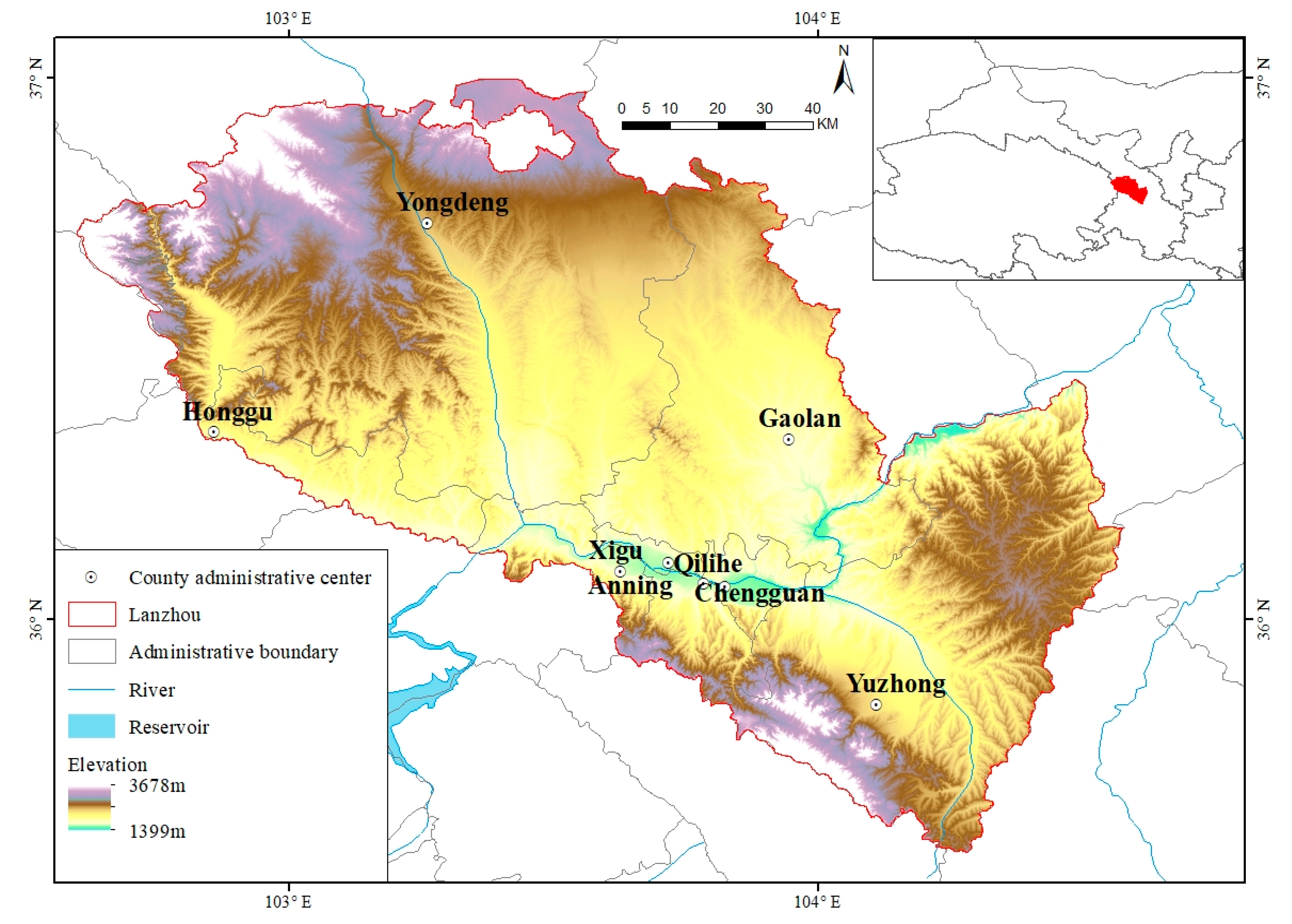
2.1. Study Area
2.2. Data Sources
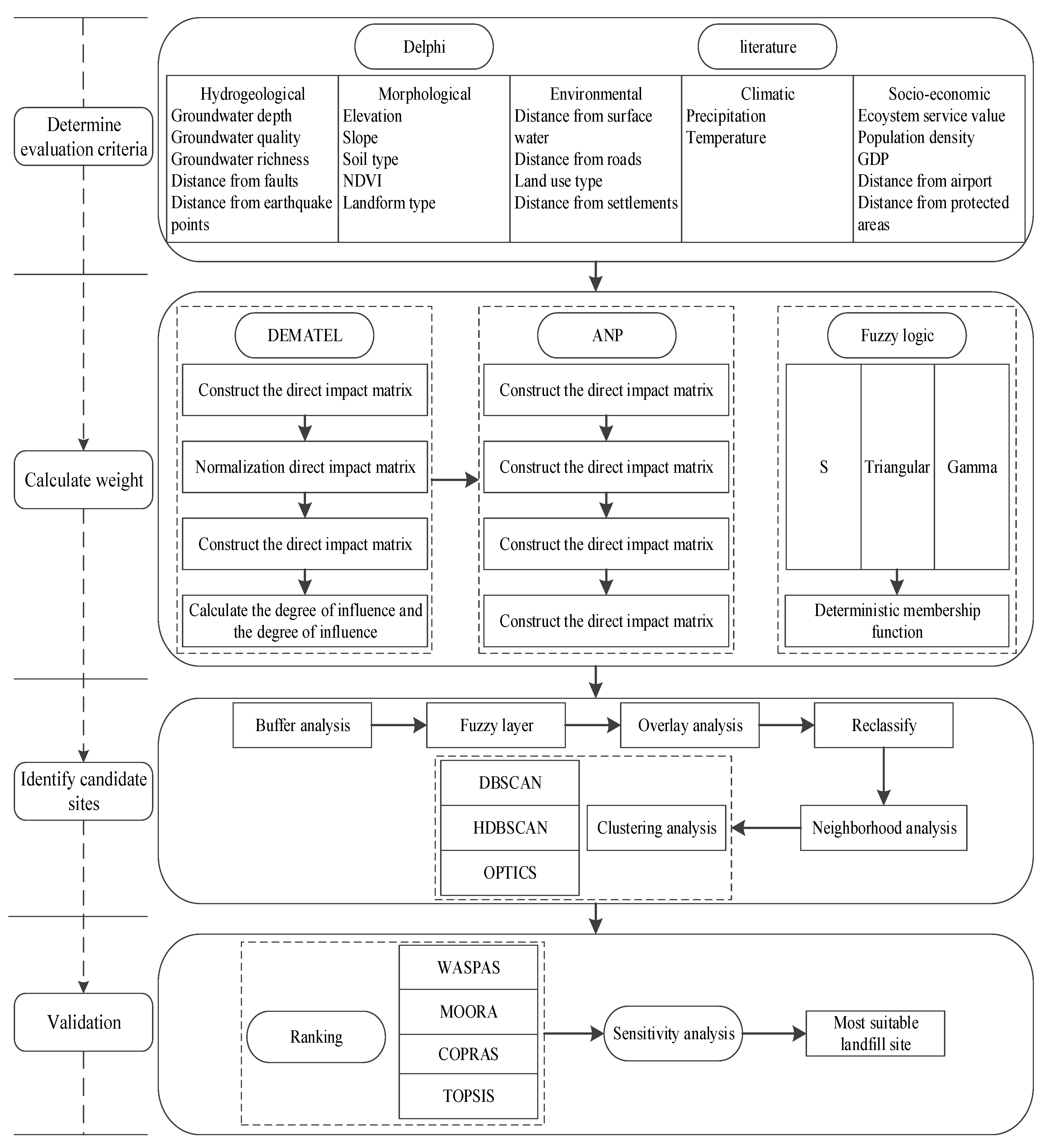
3. Methods
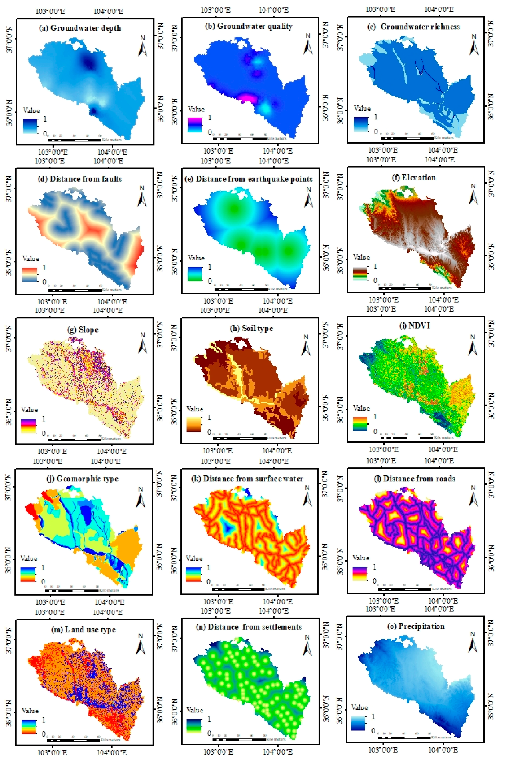
3.1. Identification of Evaluation Criteria
3.2. Fuzzy DEMATEL-ANP
3.2.1. Construction of Direct Influence Matrix
3.2.2. Normalization Directly Influences the Matrix
3.2.3. Deriving the Comprehensive Influence Matrix
3.2.4. Computing and Being Influences of the Matrix
3.2.5. Establishing the Network Structure
3.2.6. Normalization of Comprehensive Influence Matrix
3.2.7. Construct and Solve the Limit Super Matrix
3.2.8. Fuzzy Logic
3.3. GIS Modeling
3.3.1. Spatial Analysis
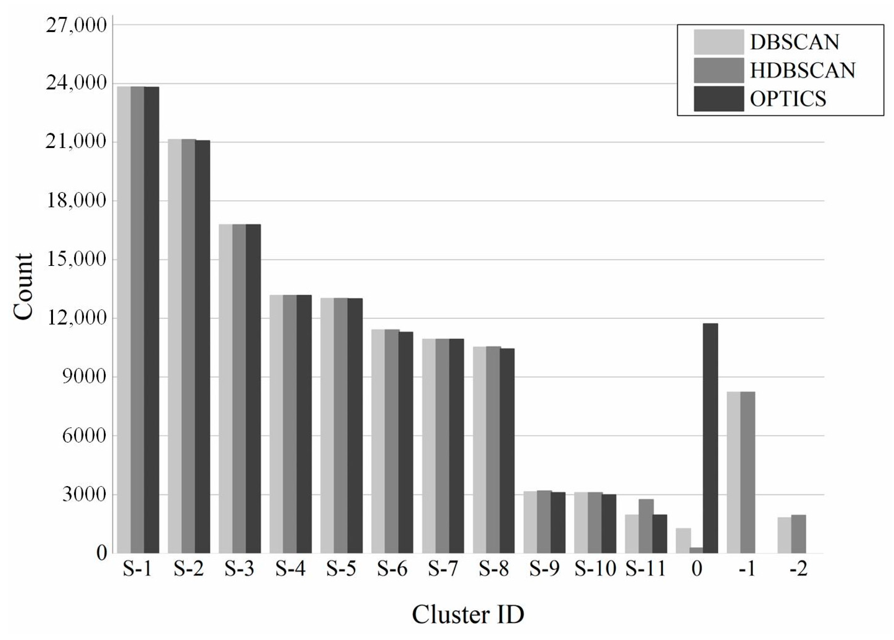
3.3.2. Cluster Analysis
3.4. Ranking Solution
3.4.1. WASPAS (Weighted Aggregated Sum Product Assessment)
3.4.2. MOORA (Multi-Objective Optimization by Ratio Analysis)
3.4.3. COPRAS (COmplex PRoportional ASsessment)
3.4.4. TOPSIS (Technique for Order of Preference by Similarity to Ideal Solution)
4. Results
4.1. Determining the Weight
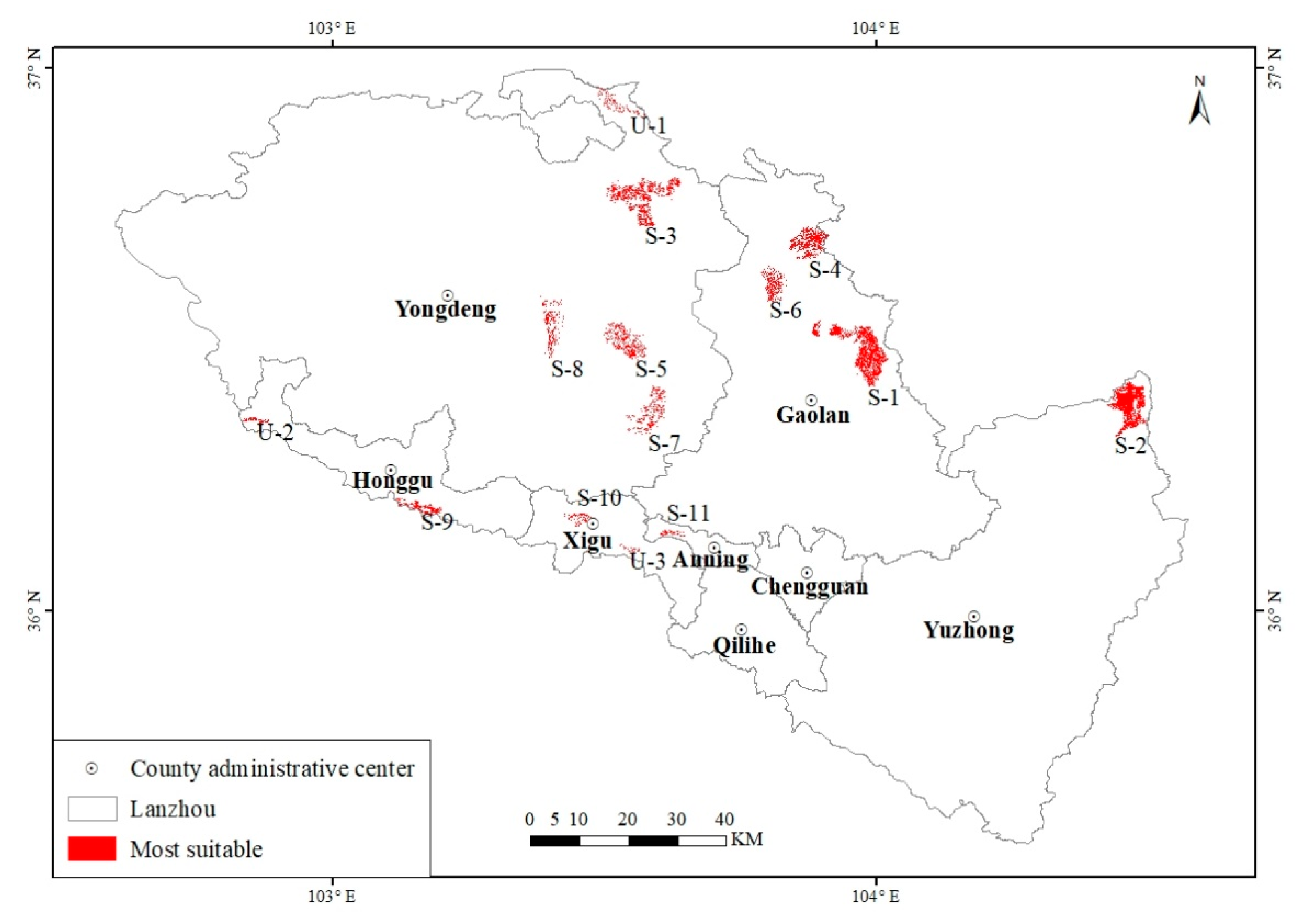
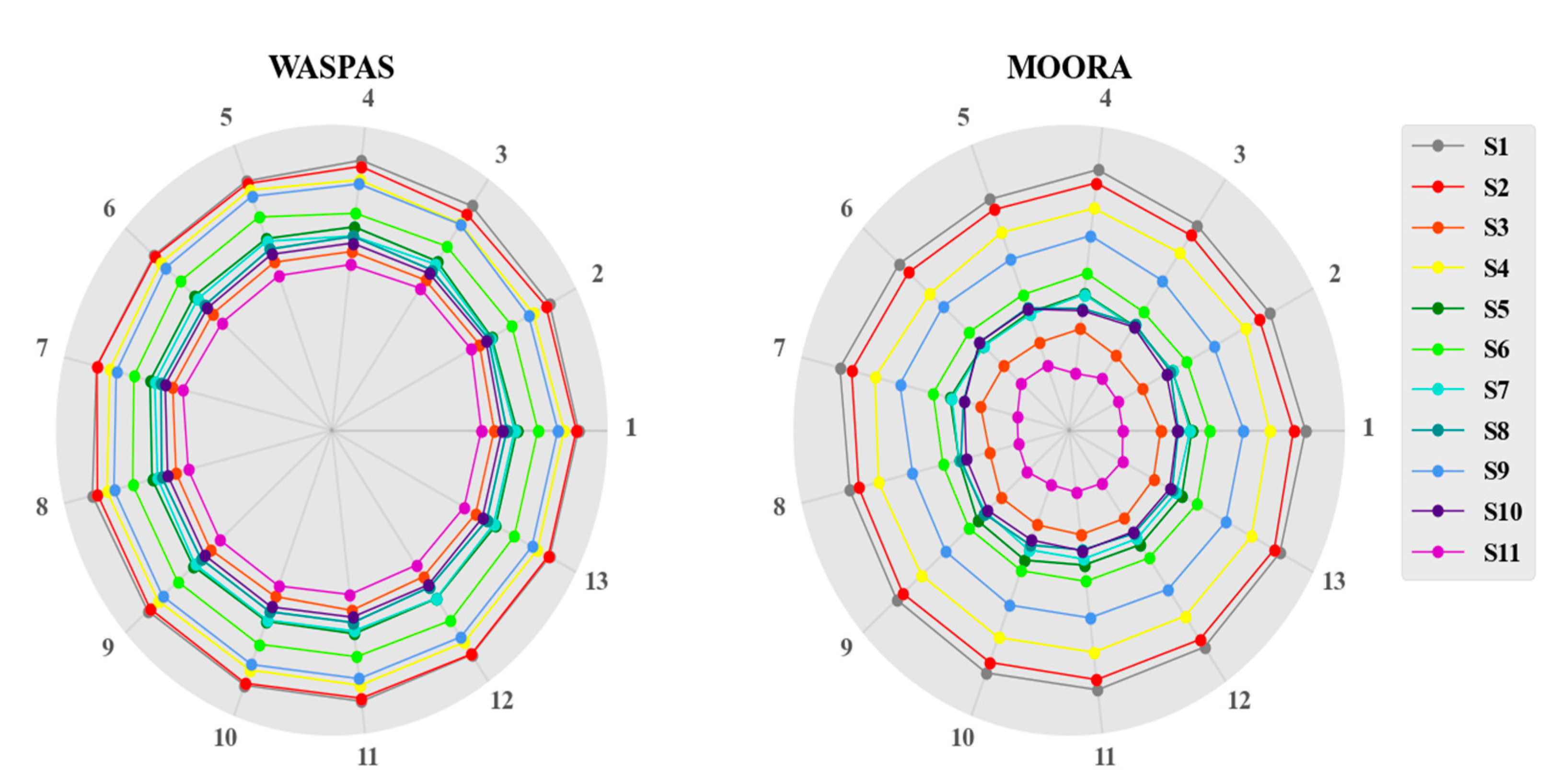
4.2. Identifying the Landfill Site
4.3. Validation
5. Discussion
6. Conclusions
Author Contributions
Funding
Institutional Review Board Statement
Informed Consent Statement
Data Availability Statement
Acknowledgments
Conflicts of Interest
Appendix A

| Dataset | Format | Data Source |
|---|---|---|
| Groundwater depth, Groundwater quality | Vector (Point) | Gansu Groundwater Report (Gansu Water Resources Department) (http://slt.gansu.gov.cn/, accessed on 15 November 2019) |
| Groundwater richness | Vector (Polygon) | “Gansu Hydrogeological Map” (Gansu Bureau of Geology and Mineral Hydrogeology engineering Geological Exploration Institute) (http://www.gssgy.com/, accessed on 15 November 2019) |
| Faults | Vector (Polyline) | “Gansu Hydrogeological Map” (Gansu Bureau of Geology and Mineral Hydrogeology engineering Geological Exploration Institute) (http://www.gssgy.com/, accessed on 15 November 2019) |
| Earthquake points | Vector (Point) | “China Historical Earthquake Catalog” (Gansu Earthquake Agency) (http://www.gsdzj.gov.cn/, accessed on 15 November 2019) |
| 30 m SRTM Elevation | Raster | USGS Earth Explorer (https://earthexplorer.usgs.gov/, accessed on 26 December 2019) |
| Landform type | Raster | “Landscape Atlas of the People’s Republic of China (1:1 million)” Resource and Environmental Science and Data Center, Chinese Academy of Sciences (http://www.resdc.cn/, accessed on 26 December 2019) |
| NDVI | Raster | MODIS (https://modis.gsfc.nasa.gov/, accessed on 20 December 2020) |
| Soil type | Raster | “The Soil Atlas of the People’s Republic of China (1: 1 million)” Resource and Environmental Science and Data Center, Chinese Academy of Sciences (http://www.resdc.cn/, accessed on 20 December 2020) |
| surface water | Vector (Polyline) | National Catalogue Service for Geographic Information (https://webmap.cn/, accessed on 20 December 2020) |
| 30 m Land use type | Raster | Resource and Environmental Science and Data Center, Chinese Academy of Sciences (http://www.resdc.cn/, accessed on 15 November 2020) |
| Settlements | Vector (Point) | National Catalogue Service for Geographic Information (https://webmap.cn/, accessed on 14 December 2020) |
| Roads | Vector (Polygon) | National Catalogue Service for Geographic Information (https://webmap.cn/, accessed on 13 December 2020)) |
| Precipitation | Raster | Resource and Environmental Science and Data Center, Chinese Academy of Sciences (http://www.resdc.cn/, accessed on 2 November 2019) |
| Temperature | Raster | Resource and Environmental Science and Data Center, Chinese Academy of Sciences (http://www.resdc.cn/, accessed on 14 November 2020) |
| Ecological function reserves | Vector (Polygon) | Portal website of Gansu Forestry and Grass Bureau and its administrative departments (http://lycy.gansu.gov.cn/, accessed on 25 December 2019) |
| Population density | Raster | Resource and Environmental Science and Data Center, Chinese Academy of Sciences (http://www.resdc.cn/, accessed on 28 December 2019) |
| GDP | Raster | Resource and Environmental Science and Data Center, Chinese Academy of Sciences (http://www.resdc.cn/, accessed on 28 December 2019) |
| Airports | Vector (Point) | Crawled POI data Official website of Gold Maps (https://lbs.amap.com/, accessed on 14 December 2020) |
| Ecosystem service value | Raster | Resource and Environmental Science and Data Center, Chinese Academy of Sciences (http://www.resdc.cn/, accessed on 14 December 2020) |
Appendix B
| Criteria | Sub-Criteria | Attribute | Rank | Conditions to Be Met | Type |
|---|---|---|---|---|---|
| Hydrogeological B1 | Groundwater depth C1 | <5 | 1 | The landfill should develop at locations with sufficient groundwater depth [24] | positive |
| 5–20 | 2 | ||||
| 20–50 | 3 | ||||
| 50–70 | 4 | ||||
| >70 | 5 | ||||
| Groundwater quality C2 | I | 1 | The landfill should be located in areas with poor water quality [61] | negative | |
| II | 2 | ||||
| III | 3 | ||||
| IV | 4 | ||||
| V | 5 | ||||
| Groundwater richness C3 | >1000 | 1 | The landfill should be located in an area with low groundwater richness [62] | positive | |
| 600–1000 | 2 | ||||
| 300–600 | 3 | ||||
| 100–300 | 4 | ||||
| <100 | 5 | ||||
| Distance from faults C4 | <1 | 1 | The landfill avoided in areas with active geological structures or other underground terrain [63] | negative | |
| 3–1 | 2 | ||||
| 5–3 | 3 | ||||
| 6–5 | 4 | ||||
| >6 | 5 | ||||
| Distance from earthquake points C5 | <5 | 1 | The landfill should be located far away from the earthquake point to reduce the possibility of natural disasters [63] | negative | |
| 15–5 | 2 | ||||
| 25–15 | 3 | ||||
| 30–25 | 4 | ||||
| >30 | 5 | ||||
| Morphological B2 | Elevation C6 | >2000 | 1 | The landfill should not be located in high-altitude areas [64] | positive |
| 1750–2000 | 2 | ||||
| 1500–1750 | 3 | ||||
| 1250–1500 | 4 | ||||
| 1000–1250 | 5 | ||||
| Slope C7 | >60 | 1 | The landfill should be located in a low slope area [7] | positive | |
| 40–60 | 2 | ||||
| 20–40 | 3 | ||||
| 10–20 | 4 | ||||
| <10 | 5 | ||||
| Soil type C8 | Aquatic soil, leached soil, anthropogenic soil | 1 | The landfill should be located in areas with sandy soil [65] | negative | |
| Semi–aqueous soil, rock soil, calcareous soil, primordial soil, semi–leached soil | 2 | ||||
| Arid soil | 3 | ||||
| Alpine soil, desert soil | 4 | ||||
| Saline soil | 5 | ||||
| NDVI C9 | >0.8 | 1 | The landfill should be located in an area with low vegetation coverage [66] | positive | |
| 0.5–0.8 | 2 | ||||
| 0.3–0.5 | 3 | ||||
| 0.2–0.3 | 4 | ||||
| <0.2 | 5 | ||||
| Landform type C10 | Medium and large rolling mountains | 1 | The landfill should be located in the plain area [67] | negative | |
| Small rolling mountain | 2 | ||||
| hills | 3 | ||||
| Terraces | 4 | ||||
| Plains | 5 | ||||
| Environmental B3 | Distance from surface water C11 | <0.5 | 1 | The landfill should not be located near ambient surface water such as ponds, lakes, rivers, and streams to avoid their contamination [68] | negative |
| 1–0.5 | 2 | ||||
| 1.5–1 | 3 | ||||
| 2–1.5 | 4 | ||||
| >2 | 5 | ||||
| Distance from roads C12 | >3 | 1 | In view of the high transportation costs, the landfill should not be too far away from the road network [7] | positive | |
| <0.5 | 2 | ||||
| 2–3 | 3 | ||||
| 0.5–1 | 4 | ||||
| 1–2 | 5 | ||||
| Land use type C13 | Water, snow, farmland, forestland | 1 | The landfill should be located in unused areas such as bare land [46] | negative | |
| Wetland | 2 | ||||
| Shrubland | 3 | ||||
| Grassland | 4 | ||||
| Bare land | 5 | ||||
| Distance from settlements C14 | <0.5 | 1 | The landfill should not be located near residential areas [69] | negative | |
| 1–0.5 | 2 | ||||
| 1.5–1 | 3 | ||||
| 2–1.5 | 4 | ||||
| >2 | 5 | ||||
| Climatic B4 | Precipitation C15 | >300 | 1 | The landfill should be located in arid areas [70] | positive |
| 250–300 | 2 | ||||
| 200–250 | 3 | ||||
| 180–200 | 4 | ||||
| <180 | 5 | ||||
| Temperature C16 | <3|>10 | 1 | The landfill should be located in a mild area [71] | negative | |
| 2–4 | 2 | ||||
| 4–6 | 3 | ||||
| 6–8 | 4 | ||||
| 8–10 | 5 | ||||
| Socio-economic B5 | Ecosystem service value C17 | >15,000 | 1 | The landfill should be as cheap as possible, and the value of ecosystem services represents the value of land use [72] | negative |
| 10,000–15,000 | 2 | ||||
| 5000–10,000 | 3 | ||||
| 3000–5000 | 4 | ||||
| <3000 | 5 | ||||
| Population density C18 | >300 | 1 | The landfill should be located in areas with low population density [73] | positive | |
| 200–300 | 2 | ||||
| 150–200 | 3 | ||||
| 100–150 | 4 | ||||
| <100 | 5 | ||||
| GDP C19 | >1000 | 1 | The landfill should be located in areas with low GDP [74] | negative | |
| <300 | 2 | ||||
| 600–300 | 3 | ||||
| 800–600 | 4 | ||||
| 1000–800 | 5 | ||||
| Distance from airports C20 | <3 | 1 | The landfill is a potential risk to aviation safety because they attract flocks of birds. Therefore, landfills should not be located near airports [69] | negative | |
| 6–3 | 2 | ||||
| 9–6 | 3 | ||||
| 12–9 | 4 | ||||
| >12 | 5 | ||||
| Distance from protected areas C21 | <1 | 1 | The landfill should be located in close proximity to natural reserves [64] | positive | |
| 4–1 | 2 | ||||
| 7–4 | 3 | ||||
| 10–7 | 4 | ||||
| >10 | 5 |
| B1 | B2 | B3 | B4 | B5 | |||||||||||||||||
|---|---|---|---|---|---|---|---|---|---|---|---|---|---|---|---|---|---|---|---|---|---|
| C1 | C2 | C3 | C4 | C5 | C6 | C7 | C8 | C9 | C10 | C11 | C12 | C13 | C14 | C15 | C16 | C17 | C18 | C19 | C20 | C21 | |
| C1 | 0.1513 | 0.0615 | 0.2485 | 0.1242 | 0.0466 | 0.2178 | 0.2252 | 0.1058 | 0.2684 | 0.2250 | 0.3049 | 0.0975 | 0.1288 | 0.1312 | 0.0548 | 0.0183 | 0.2538 | 0.1220 | 0.1159 | 0.0884 | 0.2503 |
| C2 | 0.0763 | 0.0526 | 0.0649 | 0.0716 | 0.1718 | 0.0566 | 0.0950 | 0.1650 | 0.0585 | 0.0866 | 0.0779 | 0.0700 | 0.2049 | 0.2189 | 0.0161 | 0.0054 | 0.0674 | 0.1900 | 0.1808 | 0.0605 | 0.0776 |
| C3 | 0.1399 | 0.1587 | 0.1128 | 0.2126 | 0.0603 | 0.2078 | 0.2081 | 0.2094 | 0.2331 | 0.2064 | 0.2558 | 0.0953 | 0.1403 | 0.1488 | 0.0488 | 0.0163 | 0.1322 | 0.1266 | 0.0981 | 0.0937 | 0.1278 |
| C4 | 0.2230 | 0.0393 | 0.1049 | 0.0796 | 0.0522 | 0.1980 | 0.1015 | 0.1886 | 0.1209 | 0.1216 | 0.1441 | 0.1072 | 0.0933 | 0.2300 | 0.0270 | 0.0090 | 0.2230 | 0.1288 | 0.1160 | 0.1859 | 0.2321 |
| C5 | 0.0954 | 0.0316 | 0.0616 | 0.0482 | 0.0333 | 0.0428 | 0.2779 | 0.1556 | 0.0797 | 0.0723 | 0.1002 | 0.0970 | 0.0913 | 0.0801 | 0.0169 | 0.0056 | 0.1831 | 0.1143 | 0.0695 | 0.1541 | 0.0703 |
| C6 | 0.1137 | 0.0386 | 0.1090 | 0.0972 | 0.0471 | 0.0839 | 0.0935 | 0.1757 | 0.2005 | 0.1024 | 0.2349 | 0.0890 | 0.0956 | 0.2004 | 0.0337 | 0.0112 | 0.2054 | 0.1092 | 0.1061 | 0.0815 | 0.2129 |
| C7 | 0.1127 | 0.0655 | 0.0983 | 0.1127 | 0.0655 | 0.0983 | 0.1209 | 0.0786 | 0.2241 | 0.1011 | 0.2655 | 0.1847 | 0.2132 | 0.1257 | 0.0361 | 0.0120 | 0.2210 | 0.1960 | 0.0915 | 0.0680 | 0.1312 |
| C8 | 0.0872 | 0.0670 | 0.0803 | 0.0676 | 0.0666 | 0.0520 | 0.0781 | 0.0435 | 0.0817 | 0.1790 | 0.0822 | 0.1688 | 0.2124 | 0.1510 | 0.0290 | 0.0097 | 0.0581 | 0.2811 | 0.1811 | 0.1499 | 0.0899 |
| C9 | 0.0796 | 0.0395 | 0.0877 | 0.0688 | 0.0282 | 0.0564 | 0.0635 | 0.0502 | 0.0673 | 0.0648 | 0.1963 | 0.0757 | 0.0633 | 0.0755 | 0.1258 | 0.0419 | 0.1713 | 0.0786 | 0.0772 | 0.1547 | 0.1777 |
| C10 | 0.1823 | 0.0464 | 0.0755 | 0.0678 | 0.0501 | 0.0671 | 0.0782 | 0.0428 | 0.1795 | 0.0715 | 0.0990 | 0.0676 | 0.1581 | 0.1788 | 0.1390 | 0.0463 | 0.0776 | 0.0452 | 0.0398 | 0.0459 | 0.0733 |
| C11 | 0.2604 | 0.0797 | 0.3485 | 0.3482 | 0.0617 | 0.2576 | 0.2431 | 0.1402 | 0.1656 | 0.1306 | 0.2021 | 0.0943 | 0.2221 | 0.1592 | 0.0329 | 0.0110 | 0.1658 | 0.1135 | 0.0901 | 0.0968 | 0.1557 |
| C12 | 0.2166 | 0.0437 | 0.1955 | 0.0829 | 0.1550 | 0.0915 | 0.2370 | 0.0768 | 0.2241 | 0.0965 | 0.1407 | 0.0825 | 0.0814 | 0.1875 | 0.0356 | 0.0119 | 0.1227 | 0.0806 | 0.0576 | 0.0707 | 0.0973 |
| C13 | 0.1157 | 0.1554 | 0.1997 | 0.2155 | 0.1712 | 0.1070 | 0.1292 | 0.1056 | 0.0891 | 0.0907 | 0.2137 | 0.0728 | 0.0942 | 0.2181 | 0.0200 | 0.0067 | 0.1016 | 0.0843 | 0.0670 | 0.0743 | 0.0869 |
| C14 | 0.2466 | 0.0363 | 0.1044 | 0.1792 | 0.1611 | 0.1999 | 0.2371 | 0.0915 | 0.1441 | 0.1989 | 0.1433 | 0.1917 | 0.0958 | 0.1256 | 0.0381 | 0.0127 | 0.1430 | 0.0884 | 0.0663 | 0.0772 | 0.1186 |
| C15 | 0.0473 | 0.1251 | 0.0397 | 0.0227 | 0.0439 | 0.0223 | 0.0485 | 0.0313 | 0.0463 | 0.0636 | 0.0332 | 0.1706 | 0.0407 | 0.0587 | 0.0122 | 0.3374 | 0.0285 | 0.0344 | 0.0301 | 0.0189 | 0.0258 |
| C16 | 0.0443 | 0.0100 | 0.0301 | 0.0167 | 0.0228 | 0.0176 | 0.0350 | 0.0133 | 0.0448 | 0.1298 | 0.0266 | 0.1278 | 0.0266 | 0.0407 | 0.0194 | 0.0065 | 0.0223 | 0.0140 | 0.0108 | 0.0130 | 0.0190 |
| C17 | 0.2389 | 0.0606 | 0.1447 | 0.1036 | 0.0600 | 0.0983 | 0.1210 | 0.1754 | 0.1360 | 0.2289 | 0.2481 | 0.1879 | 0.1420 | 0.1495 | 0.0410 | 0.0137 | 0.1110 | 0.2178 | 0.2266 | 0.0796 | 0.2373 |
| C18 | 0.0691 | 0.1491 | 0.0723 | 0.0708 | 0.0664 | 0.0562 | 0.0688 | 0.0531 | 0.0629 | 0.0733 | 0.0839 | 0.0515 | 0.1870 | 0.2101 | 0.0151 | 0.0051 | 0.0633 | 0.0678 | 0.1871 | 0.0476 | 0.1753 |
| C19 | 0.0728 | 0.0336 | 0.0661 | 0.0633 | 0.0476 | 0.0517 | 0.0603 | 0.0356 | 0.0687 | 0.1645 | 0.0776 | 0.0461 | 0.1636 | 0.1850 | 0.0259 | 0.0086 | 0.0580 | 0.0470 | 0.0543 | 0.0414 | 0.1573 |
| C20 | 0.0591 | 0.0255 | 0.0413 | 0.0370 | 0.0425 | 0.0386 | 0.0603 | 0.0246 | 0.0479 | 0.0410 | 0.0409 | 0.1473 | 0.0405 | 0.1693 | 0.0099 | 0.0033 | 0.0365 | 0.1374 | 0.0346 | 0.0212 | 0.0435 |
| C21 | 0.1103 | 0.0645 | 0.2155 | 0.1075 | 0.0460 | 0.0909 | 0.0984 | 0.0805 | 0.2060 | 0.1193 | 0.2425 | 0.0827 | 0.1247 | 0.1425 | 0.0315 | 0.0105 | 0.1996 | 0.2039 | 0.3136 | 0.1752 | 0.1369 |
| B1 | B2 | B3 | B4 | B5 | |
|---|---|---|---|---|---|
| B1 | 0.1100 | 0.3247 | 0.0529 | 0.0151 | 0.0151 |
| B2 | 0.3851 | 0.1365 | 0.1850 | 0.0529 | 0.0529 |
| B3 | 0.4757 | 0.3058 | 0.1893 | 0.3398 | 0.3398 |
| B4 | 0.2265 | 0.0901 | 0.1775 | 0.0507 | 0.0507 |
| B5 | 0.1359 | 0.0874 | 0.3398 | 0.0971 | 0.0971 |
Appendix C

Appendix D
| Landfill | I | II | III | IV |
|---|---|---|---|---|
| Area (Km2) | >12 | 5–12 | 2–5 | 1–2 |
| Amount of MSW (tons/day) | >1200 | 500–1200 | 200–500 | <200 |
Appendix E

References
- Soltani, A.; Hewage, K.; Reza, B.; Sadiq, R. Multiple stakeholders in multi-criteria decision-making in the context of Municipal Solid Waste Management: A review. Waste Manag. 2015, 35, 318–328. [Google Scholar] [CrossRef] [PubMed]
- Kamdar, I.; Ali, S.; Bennui, A.; Techato, K.; Jutidamrongphan, W. Municipal solid waste landfill siting using an integrated GIS-AHP approach: A case study from Songkhla, Thailand. Resour. Conserv. Recycl. 2019, 149, 220–235. [Google Scholar] [CrossRef]
- Khan, M.M.-U.-H.; Vaezi, M.; Kumar, A. Optimal siting of solid waste-to-value-added facilities through a GIS-based assessment. Sci. Total Environ. 2018, 610, 1065–1075. [Google Scholar] [CrossRef]
- Hanine, M.; Boutkhoum, O.; Tikniouine, A.; Agouti, T. Comparison of fuzzy AHP and fuzzy TODIM methods for landfill location selection. Springerplus 2016, 5. [Google Scholar] [CrossRef] [PubMed]
- Zhang, T.; Shi, J.; Qian, X.; Ai, Y. Temperature and Gas Pressure Monitoring and Leachate Pumping Tests in a Newly Filled MSW Layer of a Landfill. Int. J. Environ. Res. 2019, 13, 1–19. [Google Scholar] [CrossRef]
- Krcmar, D.; Tenodi, S.; Grba, N.; Kerkez, D.; Watson, M.; Roncevic, S.; Dalmacija, B. Preremedial assessment of themunicipal landfill pollution impact on soil and shallow groundwater in Subotica, Serbia. Sci. Total Environ. 2018, 615, 1341–1354. [Google Scholar] [CrossRef]
- Chabuk, A.; Al-Ansari, N.; Hussain, H.M.; Knutsson, S.; Pusch, R. Landfill site selection using geographic information system and analytical hierarchy process: A case study Al-Hillah Qadhaa, Babylon, Iraq. Waste Manag. Res. 2016, 34, 427–437. [Google Scholar] [CrossRef]
- Asefi, H.; Zhang, Y.; Lim, S.; Maghrebi, M.; Shahparvari, S. A multi-criteria decision support framework for municipal solid waste landfill siting: A case study of New South Wales (Australia). Environ. Monit. Assess. 2020, 192. [Google Scholar] [CrossRef]
- Bahrani, S.; Ebadi, T.; Ehsani, H.; Yousefi, H.; Maknoon, R. Modeling landfill site selection by multi-criteria decision making and fuzzy functions in GIS, case study: Shabestar, Iran. Environ. Earth Sci. 2016, 75. [Google Scholar] [CrossRef]
- Chamchali, M.M.; Ghazifard, A. The use of fuzzy logic spatial modeling via GIS for landfill site selection (case study: Rudbar-Iran). Environ. Earth Sci. 2019, 78. [Google Scholar] [CrossRef]
- Gbanie, S.P.; Tengbe, P.B.; Momoh, J.S.; Medo, J.; Kabba, V.T.S. Modelling landfill location using Geographic Information Systems (GIS) and Multi-Criteria Decision Analysis (MCDA): Case study Bo, Southern Sierra Leone. Appl. Geogr. 2013, 36, 3–12. [Google Scholar] [CrossRef]
- Gorsevski, P.V.; Donevska, K.R.; Mitrovski, C.D.; Frizado, J.P. Integrating multi-criteria evaluation techniques with geographic information systems for landfill site selection: A case study using ordered weighted average. Waste Manag. 2012, 32, 287–296. [Google Scholar] [CrossRef] [PubMed]
- Beskese, A.; Demir, H.H.; Ozcan, H.K.; Okten, H.E. Landfill site selection using fuzzy AHP and fuzzy TOPSIS: A case study for Istanbul. Environ. Earth Sci. 2015, 73, 3513–3521. [Google Scholar] [CrossRef]
- Wu, Y.; He, F.; Zhou, J.; Wu, C.; Liu, F.; Tao, Y.; Xu, C. Optimal site selection for distributed wind power coupled hydrogen storage project using a geographical information system based multi-criteria decision-making approach: A case in China. J. Clean. Prod. 2021, 299. [Google Scholar] [CrossRef]
- Torkayesh, A.E.; Zolfani, S.H.; Kahvand, M.; Khazaelpour, P. Landfill location selection for healthcare waste of urban areas using hybrid BWM-grey MARCOS model based on GIS. Sustain. Cities Soc. 2021, 67. [Google Scholar] [CrossRef]
- Mahmood, K.; Batool, S.A.; Chaudhary, M.N.; Ul-Haq, Z. Ranking criteria for assessment of municipal solid waste dumping sites. Arch. Environ. Prot. 2017, 43, 95–105. [Google Scholar] [CrossRef]
- Demesouka, O.E.; Vavatsikos, A.P.; Anagnostopoulos, K.P. Suitability analysis for siting MSW landfills and its multicriteria spatial decision support system: Method, implementation and case study. Waste Manag. 2013, 33, 1190–1206. [Google Scholar] [CrossRef]
- Spigolon, L.M.G.; Giannotti, M.; Larocca, A.P.; Russo, M.A.T.; Souza, N.D. Landfill siting based on optimisation, multiple decision analysis, and geographic information system analyses. Waste Manag. Res. 2018, 36, 606–615. [Google Scholar] [CrossRef] [PubMed]
- Aksoy, E.; San, B.T. Geographical information systems (GIS) and Multi-Criteria Decision Analysis (MCDA) integration for sustainable landfill site selection considering dynamic data source. Bull. Eng. Geol. Environ. 2019, 78, 779–791. [Google Scholar] [CrossRef]
- Hossaini, N.; Reza, B.; Akhtar, S.; Sadiq, R.; Hewage, K. AHP based life cycle sustainability assessment (LCSA) framework: A case study of six storey wood frame and concrete frame buildings in Vancouver. J. Environ. Plan. Manag. 2015, 58, 1217–1241. [Google Scholar] [CrossRef]
- Daneshfar, M.A.; Ardjmand, M. A new approach in the optimal site selection of landfills for drilling cuttings from petroleum and gas fields. Chemosphere 2021, 270, 129402. [Google Scholar] [CrossRef]
- Liu, H.; Long, H.; Li, X. Identification of critical factors in construction and demolition waste recycling by the grey-DEMATEL approach: A Chinese perspective. Environ. Sci. Pollut. Res. 2020, 27, 8507–8525. [Google Scholar] [CrossRef] [PubMed]
- Feyz, S.; Khanmohammadi, M.; Abedinzadeh, N.; Aalipour, M. Multi-criteria decision analysis FANP based on GIS for siting municipal solid waste incineration power plant in the north of Iran. Sust. Cities Soc. 2019, 47, 12. [Google Scholar] [CrossRef]
- Rezaeisabzevar, Y.; Bazargan, A.; Zohourian, B. Landfill site selection using multi criteria decision making: Influential factors for comparing locations. J. Environ. Sci. 2020, 93, 170–184. [Google Scholar] [CrossRef] [PubMed]
- Karimi, H.; Amiri, S.; Huang, J.; Karimi, A. Integrating GIS and multi-criteria decision analysis for landfill site selection, case study: Javanrood County in Iran. Int. J. Environ. Sci. Technol. 2019, 16, 7305–7318. [Google Scholar] [CrossRef]
- Ziemba, P.; Watrobski, J. Selected Issues of Rank Reversal Problem in ANP Method. In Proceedings of the Selected Issues in Experimental Economics, Miedzyzdroje, Poland, 30 November–1 December 2016; Nermend, K., Latuszynska, M., Eds.; pp. 203–225. [Google Scholar] [CrossRef]
- Forman, E.H.; Selly, M.A. The Analytic Hierarchy Process and Expert Choice. World Sci. Book Chapters 2001, 43–125. [Google Scholar] [CrossRef]
- Eghtesadifard, M.; Afkhami, P.; Bazyar, A. An integrated approach to the selection of municipal solid waste landfills through GIS, K-Means and multi-criteria decision analysis. Environ. Res. 2020, 185. [Google Scholar] [CrossRef]
- Isalou, A.A.; Zamani, V.; Shahmoradi, B.; Alizadeh, H. Landfill site selection using integrated fuzzy logic and analytic network process (F-ANP). Environ. Earth Sci. 2013, 68, 1745–1755. [Google Scholar] [CrossRef]
- Rahimi, S.; Hafezalkotob, A.; Monavari, S.M.; Hafezalkotob, A.; Rahimi, R. Sustainable landfill site selection for municipal solid waste based on a hybrid decision-making approach: Fuzzy group BWM-MULTIMOORA-GIS. J. Clean. Prod. 2020, 248. [Google Scholar] [CrossRef]
- Mohammadi Seif Abad, P.; Pazira, E.; Masih Abadi, M.H.; Abdinezhad, P. Application AHP-PROMETHEE Technic for Landfill Site Selection on Based Assessment of Aquifers Vulnerability to Pollution. Iran. J. Sci. Technol. Trans. Civ. Eng. 2021. [Google Scholar] [CrossRef]
- Hariz, H.A.; Donmez, C.C.; Sennaroglu, B. Siting of a central healthcare waste incinerator using GIS-based Multi Criteria Decision Analysis. J. Clean. Prod. 2017, 166, 1031–1042. [Google Scholar] [CrossRef]
- Li, J.; Wang, Z.; Chen, L.; Lian, L.; Li, Y.; Zhao, L.; Zhou, S.; Mao, X.; Huang, T.; Gao, H.; et al. WRF-Chem simulations of ozone pollution and control strategy in petrochemical industrialized and heavily polluted Lanzhou City, Northwestern China. Sci. Total Environ. 2020, 737, 139835. [Google Scholar] [CrossRef]
- Jiang, Y.; Yuan, L.; Wen, H.; Zhang, Q.; Liu, L.; Wu, Y. Distribution, Composition, Sources, and Potential Ecological Risks of PAHs in the Sediments of the Lanzhou Reach of the Yellow River, China. Bull. Environ. Contam. Toxicol. 2020, 105, 613–619. [Google Scholar] [CrossRef]
- Liu, Y.; Hao, S.; Zhao, X.; Li, X.; Qiao, X.; Dionysiou, D.D.; Zheng, B. Distribution characteristics and health risk assessment of volatile organic compounds in the groundwater of Lanzhou City, China. Environ. Geochem. Health 2020, 42, 3609–3622. [Google Scholar] [CrossRef] [PubMed]
- Yang, X.; Jia, Y.; Zhang, D.; Zhang, X.; Zhang, H.; Hou, Y. Research on the anti-interference capability of the tourism environment system for the core stakeholders of semi-arid valley-type cities: Analysis based on the multi-scenario and time series diversity perspectives. Environ. Sci. Pollut. Res. 2020, 27, 40020–40040. [Google Scholar] [CrossRef]
- Zhao, S.; Yu, Y.; Du, Z.; Yin, D.; Yang, J.; Dong, L.; Li, P. Size-resolved carbonaceous aerosols at near surface level and the hilltop in a typical valley city, China. Atmos. Pollut. Res. 2020, 11, 129–140. [Google Scholar] [CrossRef]
- Juang, C.H.; Dijkstra, T.; Wasowski, J.; Meng, X. Loess geohazards research in China: Advances and challenges for mega engineering projects. Eng. Geol. 2019, 251, 1–10. [Google Scholar] [CrossRef]
- He, S.; Wang, X.; Dong, J.; Wei, B.; Duan, H.; Jiao, J.; Xie, Y. Three-Dimensional Urban Expansion Analysis of Valley-Type Cities: A Case Study of Chengguan District, Lanzhou, China. Sustainability 2019, 11, 5663. [Google Scholar] [CrossRef]
- Ahmed, F.; Ahmad, G.; Brand, T.; Zeeb, H. Key indicators for appraising adolescent sexual and reproductive health in South Asia: International expert consensus exercise using the Delphi technique. Glob. Health Action 2020, 13. [Google Scholar] [CrossRef]
- Karakus, C.B.; Demiroglu, D.; Coban, A.; Ulutas, A. Evaluation of GIS-based multi-criteria decision-making methods for sanitary landfill site selection: The case of Sivas city, Turkey. J. Mater. Cycles Waste Manag. 2020, 22, 254–272. [Google Scholar] [CrossRef]
- Ozkan, B.; Ozceylan, E.; Saricicek, I. GIS-based MCDM modeling for landfill site suitability analysis: A comprehensive review of the literature. Environ. Sci. Pollut. Res. 2019, 26, 30711–30730. [Google Scholar] [CrossRef] [PubMed]
- Lima, R.M.; Santos, A.H.M.; Pereira, C.R.S.; Flauzino, B.K.; Pereira, A.C.O.S.; Nogueira, F.J.H.; Valverde, J.A.R. Spatially distributed potential of landfill biogas production and electric power generation in Brazil. Waste Manag. 2018, 74, 323–334. [Google Scholar] [CrossRef] [PubMed]
- Asefi, H.; Zhang, Y.; Lim, S.; Maghrebi, M. An integrated approach to suitability assessment of municipal solid waste landfills in New South Wales, Australia. Australas. J. Environ. Manag. 2020, 27, 63–83. [Google Scholar] [CrossRef]
- Chang, B.; Chang, C.-W.; Wu, C.-H. Fuzzy DEMATEL method for developing supplier selection criteria. Expert Syst. Appl. 2011, 38, 1850–1858. [Google Scholar] [CrossRef]
- Afzali, A.; Sabri, S.; Rashid, M.; Samani, J.M.V.; Ludin, A.N.M. Inter-Municipal Landfill Site Selection Using Analytic Network Process. Water Resour. Manag. 2014, 28, 2179–2194. [Google Scholar] [CrossRef]
- Motlagh, Z.K.; Sayadi, M.H. Siting MSW landfills using MCE methodology in GIS environment (Case study: Birjand plain, Iran). Waste Manag. 2015, 46, 322–337. [Google Scholar] [CrossRef]
- Barakat, A.; Hilali, A.; El Baghdadi, M.; Touhami, F. Landfill site selection with GIS-based multi-criteria evaluation technique. A case study in Beni Mellal-Khouribga Region, Morocco. Environ. Earth Sci. 2017, 76. [Google Scholar] [CrossRef]
- Kumar, P. Optimal policies for inventory model with shortages, time-varying holding and ordering costs in trapezoidal fuzzy environment. Indep. J. Manag. Prod. 2021, 12, 557–574. [Google Scholar] [CrossRef]
- Kumar, K.; Chen, S.-M. Multiattribute decision making based on interval-valued intuitionistic fuzzy values, score function of connection numbers, and the set pair analysis theory. Inf. Sci. 2021, 551, 100–112. [Google Scholar] [CrossRef]
- Saleh, S.K.; Aliani, H.; Amoushahi, S. Application of modeling based on fuzzy logic with multi-criteria method in determining appropriate municipal landfill sites (case study: Kerman City). Arab. J. Geosci. 2020, 13. [Google Scholar] [CrossRef]
- Sener, E.; Sener, S. Landfill site selection using integrated fuzzy logic and analytic hierarchy process (AHP in lake basins. Arab. J. Geosci. 2020, 13. [Google Scholar] [CrossRef]
- Zarin, R.; Azmat, M.; Naqvi, S.R.; Saddique, Q.; Ullah, S. Landfill site selection by integrating fuzzy logic, AHP, and WLC method based on multi-criteria decision analysis. Environ. Sci. Pollut. Res. 2021. [Google Scholar] [CrossRef]
- Gui, Z.; Peng, D.; Wu, H.; Long, X. MSGC: Multi-scale grid clustering by fusing analytical granularity and visual cognition for detecting hierarchical spatial patterns. Future Gener. Comput. Syst. Int. J. Escience 2020, 112, 1038–1056. [Google Scholar] [CrossRef]
- Hu, S.; He, Z.; Wu, L.; Yin, L.; Xu, Y.; Cui, H. A framework for extracting urban functional regions based on multiprototype word embeddings using points-of-interest data. Comput. Environ. Urban Syst. 2020, 80. [Google Scholar] [CrossRef]
- Breunig, M.M.; Kriegel, H.-P.; Sander, J. Fast Hierarchical Clustering Based on Compressed Data and OPTICS. Lect. Notes Comput. Sci. 2000, 1910, 232–242. [Google Scholar]
- Zavadskas, E.K.; Turskis, Z.; Antucheviciene, J.; Zakarevicius, A. Optimization of Weighted Aggregated Sum Product Assessment. Elektron. Ir Elektrotechnika 2012, 122, 3–6. [Google Scholar] [CrossRef]
- Brauers, W.K.M.; Zavadskas, E.K. The MOORA method and its application to privatization in a transition economy. Control Cybern. 2006, 35, 445–469. [Google Scholar]
- Pamucar, D.; Bozanic, D.; Lukovac, V.; Komazec, N. Normalized Weighted Geometric Bonferroni Mean Operator of Interval Rough Numbers—Application in Interval Rough Dematel-Copras Model. Facta Univ. Ser. Mech. Eng. 2018, 16, 171–191. [Google Scholar] [CrossRef]
- Rashid, T.; Beg, I.; Husnine, S.M. Robot selection by using generalized interval-valued fuzzy numbers with TOPSIS. Appl. Soft Comput. 2014, 21, 462–468. [Google Scholar] [CrossRef]
- Przydatek, G.; Kanownik, W. Impact of small municipal solid waste landfill on groundwater quality. Environ. Monit. Assess. 2019, 191. [Google Scholar] [CrossRef]
- Sener, S.; Sener, E.; Karaguzel, R. Solid waste disposal site selection with GIS and AHP methodology: A case study in Senirkent-Uluborlu (Isparta) Basin, Turkey. Environ. Monit. Assess. 2011, 173, 533–554. [Google Scholar] [CrossRef]
- Eskandari, M.; Homaee, M.; Mahmodi, S. An integrated multi criteria approach for landfill siting in a conflicting environmental, economical and socio-cultural area. Waste Manag. 2012, 32, 1528–1538. [Google Scholar] [CrossRef]
- Sener, S.; Sener, E.; Nas, B.; Karaguzel, R. Combining AHP with GIS for landfill site selection: A case study in the Lake Beysehir catchment area (Konya, Turkey). Waste Manag. 2010, 30, 2037–2046. [Google Scholar] [CrossRef] [PubMed]
- Soroudi, M.; Omrani, G.; Moataar, F.; Jozi, S.A. Modelling an Integrated Fuzzy Logic and Multi-Criteria Approach for Land Capability Assessment for Optimized Municipal Solid Waste Landfill Siting Yeast. Pol. J. Environ. Stud. 2018, 27, 313–323. [Google Scholar] [CrossRef]
- Kara, C.; Doratli, N. Application of GIS/AHP in siting sanitary landfill: A case study in Northern Cyprus. Waste Manag. Res. 2012, 30, 966–980. [Google Scholar] [CrossRef] [PubMed]
- Sureshkumar, M.; Sivakumar, R.; Nagarajan, M. Selection of Alternative Landfill site in Kanchipuram, India by Using Gis and Multicriteria Decision Analysis. Appl. Ecol. Environ. Res. 2017, 15, 627–636. [Google Scholar] [CrossRef]
- Uyan, M. MSW landfill site selection by combining AHP with GIS for Konya, Turkey. Environ. Earth Sci. 2014, 71, 1629–1639. [Google Scholar] [CrossRef]
- Wang, G.; Qin, L.; Li, G.; Chen, L. Landfill site selection using spatial information technologies and AHP: A case study in Beijing, China. J. Environ. Manag. 2009, 90, 2414–2421. [Google Scholar] [CrossRef]
- Augusto, P.A.; Castelo-Grande, T.; Merchan, L.; Estevez, A.M.; Quintero, X.; Barbosa, D. Landfill leachate treatment by sorption in magnetic particles: Preliminary study. Sci. Total Environ. 2019, 648, 636–668. [Google Scholar] [CrossRef]
- Aksoy, E.; San, B.T. Using MCDA and GIS for Landfill Site Selection: Central Districts of Antalya Province. In Proceedings of the XXIII Isprs Congress, Commission Ii, Prague, Czech Republic, 12–19 July 2016; Halounova, L., Li, S., Safar, V., Tomkova, M., Rapant, P., Brazdil, K., Shi, W., Anton, F., Liu, Y., Stein, A., et al., Eds.; Volume 41, pp. 151–157. [Google Scholar]
- Alavi, N.; Goudarzi, G.; Babaei, A.A.; Jaafarzadeh, N.; Hosseinzadeh, M. Municipal solid waste landfill site selection with geographic information systems and analytical hierarchy process: A case study in Mahshahr County, Iran. Waste Manag. Res. 2013, 31, 98–105. [Google Scholar] [CrossRef]
- Farahbakhsh, A.; Forghani, M.A. Sustainable location and route planning with GIS for waste sorting centers, case study: Kerman, Iran. Waste Manag. Res. 2019, 37, 287–300. [Google Scholar] [CrossRef] [PubMed]
- Aracil, C.; Haro, P.; Fuentes-Cano, D.; Gomez-Barea, A. Implementation of waste-to-energy options in landfill-dominated countries: Economic evaluation and GHG impact. Waste Manag. 2018, 76, 443–456. [Google Scholar] [CrossRef] [PubMed]


| Criterion | (R + C) | (R − C) | Sub-Criterion | (R + C) | (R − C) | Weight |
|---|---|---|---|---|---|---|
| Hydrogeological B1 | 1.85113269 | −0.81553398 | Groundwater depth C1 | 6.10592753 | 0.37294637 | 0.0710 |
| Groundwater quality C2 | 3.44870236 | 0.68060181 | 0.0416 | |||
| Groundwater richness C3 | 5.57912930 | 0.48638054 | 0.0642 | |||
| Distance from faults C4 | 4.92364358 | 0.52814645 | 0.0582 | |||
| Distance from earthquake points C5 | 3.38080534 | 0.38108087 | 0.0398 | |||
| Morphological B2 | 1.75674218 | −0.13214671 | Elevation C6 | 4.55369593 | 0.32910353 | 0.0530 |
| Slope C7 | 5.47245800 | 0.11232891 | 0.0616 | |||
| Soil type C8 | 4.25869870 | 0.17304975 | 0.0432 | |||
| NDVI C9 | 4.59700315 | −0.90900132 | 0.0380 | |||
| Landform type C10 | 4.39911408 | −0.73593001 | 0.0380 | |||
| Environmental B3 | 2.59492988 | 0.70604099 | Distance from surface water C11 | 6.59228284 | 0.16569081 | 0.0758 |
| Distance from roads C12 | 4.69565700 | 0.07977861 | 0.0523 | |||
| Land use type C13 | 5.04036583 | −0.19966298 | 0.0531 | |||
| Distance from settlements C14 | 5.88668717 | −0.48682537 | 0.0586 | |||
| Climatic B4 | 1.15102481 | 0.0399137 | Precipitation C15 | 2.09399972 | 0.46721654 | 0.0214 |
| Temperature C16 | 1.29549829 | 0.08657056 | 0.0142 | |||
| Socio-economic B5 | 1.31283711 | 0.2017260 | Ecosystem service value C17 | 5.67030678 | 0.38012955 | 0.0641 |
| Population density C18 | 4.31250111 | −0.64084310 | 0.0382 | |||
| GDP C19 | 3.74464030 | −0.68676010 | 0.0325 | |||
| Distance from airports C20 | 2.90147204 | −0.69625477 | 0.0234 | |||
| Distance from protected areas C21 | 5.50491968 | 0.11225335 | 0.0579 |
| Fuzzy Membership Function | Figure | Formula | |
|---|---|---|---|
| S-shape | S-shape (increasing) |  | |
| S-shape (general) |  | ||
| S-shape (decreasing) |  | ||
| S-shape (individual) |  | ||
| Triangular shape | Triangular shape (general) |  | |
| Gamma shape | Gamma shape (increasing) |  | |
| Country/ District | Candidate Site | Longitude | Latitude | Area (Km2) | Amount of MSW (Tons/Day) |
|---|---|---|---|---|---|
| Yongdeng | S-3 | 103°31′25″ E | 36°47′43″ N | 40.3 | >1200 |
| S-5 | 103°33′12″ E | 36°30′37″ N | 29.9 | >1200 | |
| S-7 | 103°37′14″ E | 36°20′52″ N | 28.2 | >1200 | |
| S-8 | 103°25′47″ E | 36°33′12″ N | 27.6 | >1200 | |
| Gaolan | S-1 | 103°58′40″ E | 36°29′14″ N | 41.4 | >1200 |
| S-4 | 103°53′15″ E | 36°39′55″ N | 27.7 | >1200 | |
| S-6 | 103°48′19″ E | 36°32′35″ N | 15.3 | >1200 | |
| Yuzhong | S-2 | 104°27′50″ E | 36°22′56″ N | 35.5 | >1200 |
| Honggu | S-9 | 103°12′11″ E | 36°10′58″ N | 9.8 | 500–1200 |
| Xigu | S-10 | 103°27′46″ E | 36°11′14″ N | 3.7 | 200–500 |
| Anning | S-11 | 103°37′05″ E | 36°08′37″ N | 2.6 | 200–500 |
| S-1 | S-2 | S-3 | S-4 | S-5 | S-6 | S-7 | S-8 | S-9 | S-10 | S-11 | ||
|---|---|---|---|---|---|---|---|---|---|---|---|---|
| WASPAS | Qi | 0.802 | 0.795 | 0.528 | 0.755 | 0.602 | 0.670 | 0.594 | 0.569 | 0.735 | 0.553 | 0.486 |
| Rank | 1 | 2 | 10 | 3 | 6 | 5 | 7 | 9 | 4 | 8 | 11 | |
| MOORA | Qi | 0.256 | 0.243 | 0.099 | 0.217 | 0.133 | 0.152 | 0.131 | 0.118 | 0.189 | 0.117 | 0.058 |
| Rank | 1 | 2 | 10 | 3 | 7 | 5 | 6 | 8 | 4 | 9 | 11 | |
| COPRAS | Qi | 0.219 | 0.203 | 0.111 | 0.185 | 0.139 | 0.151 | 0.138 | 0.121 | 0.170 | 0.126 | 0.102 |
| Rank | 1 | 2 | 10 | 3 | 6 | 5 | 7 | 9 | 4 | 8 | 11 | |
| TOPSIS | Qi | 0.426 | 0.432 | 0.240 | 0.408 | 0.289 | 0.321 | 0.299 | 0.266 | 0.373 | 0.265 | 0.213 |
| Rank | 1 | 2 | 10 | 3 | 7 | 5 | 6 | 8 | 4 | 9 | 11 |
| Scenario | Scenario Description | Spearman’s Correlation Coefficient | |||
|---|---|---|---|---|---|
| WASPAS | MOORA | COPRAS | TOPSIS | ||
| 1 | original weight | 1 | 1 | 1 | 1 |
| 2 | The weight of the first-ranking is substituted with the second-ranking | 1 | 1 | 1 | 1 |
| 3 | The weight of the first-ranking is substituted with the third-ranking | 1 | 1 | 1 | 1 |
| 4 | The weight of the first-ranking is substituted with the fourth-ranking | 0.9428 | 0.8857 | 0.9428 | 0.8857 |
| 5 | The weight of the second-ranking is substituted with the third-ranking | 1 | 1 | 1 | 1 |
| 6 | The weight of the second-ranking is substituted with the fourth-ranking | 0.9428 | 0.9428 | 0.9428 | 0.9428 |
| 7 | Omitting the first-ranking criterion | 0.8857 | 0.9428 | 0.8857 | 0.9428 |
| 8 | Omitting the second-ranking criterion | 1 | 1 | 1 | 1 |
| 9 | Omitting the third-ranking criterion | 1 | 1 | 1 | 1 |
| 10 | Increasing the first-ranking weight by 5% | 1 | 1 | 1 | 1 |
| 11 | Decreasing the first-ranking weight by 5% | 1 | 1 | 1 | 1 |
| 12 | Increasing the second-ranking weight by 5% | 1 | 1 | 1 | 1 |
| 13 | Decreasing the second-ranking weight by 5% | 1 | 1 | 1 | 1 |
Publisher’s Note: MDPI stays neutral with regard to jurisdictional claims in published maps and institutional affiliations. |
© 2021 by the authors. Licensee MDPI, Basel, Switzerland. This article is an open access article distributed under the terms and conditions of the Creative Commons Attribution (CC BY) license (https://creativecommons.org/licenses/by/4.0/).
Share and Cite
Liu, J.; Li, Y.; Xiao, B.; Jiao, J. Coupling Fuzzy Multi-Criteria Decision-Making and Clustering Algorithm for MSW Landfill Site Selection (Case Study: Lanzhou, China). ISPRS Int. J. Geo-Inf. 2021, 10, 403. https://doi.org/10.3390/ijgi10060403
Liu J, Li Y, Xiao B, Jiao J. Coupling Fuzzy Multi-Criteria Decision-Making and Clustering Algorithm for MSW Landfill Site Selection (Case Study: Lanzhou, China). ISPRS International Journal of Geo-Information. 2021; 10(6):403. https://doi.org/10.3390/ijgi10060403
Chicago/Turabian StyleLiu, Jiamin, Yueshi Li, Bin Xiao, and Jizong Jiao. 2021. "Coupling Fuzzy Multi-Criteria Decision-Making and Clustering Algorithm for MSW Landfill Site Selection (Case Study: Lanzhou, China)" ISPRS International Journal of Geo-Information 10, no. 6: 403. https://doi.org/10.3390/ijgi10060403
APA StyleLiu, J., Li, Y., Xiao, B., & Jiao, J. (2021). Coupling Fuzzy Multi-Criteria Decision-Making and Clustering Algorithm for MSW Landfill Site Selection (Case Study: Lanzhou, China). ISPRS International Journal of Geo-Information, 10(6), 403. https://doi.org/10.3390/ijgi10060403