Article

Deep Understanding of Urban Dynamics from Imprint Urban Toponymic Data Using a Spatial–Temporal–Semantic Analysis Approach

1
School of Earth Sciences, Zhejiang University, Hangzhou 310027, China
2
Zhejiang Provincial Key Laboratory of Geographic Information Science, Hangzhou 310028, China
3
Department of Geography, University of Connecticut, Storrs, CT 06269, USA
4
Key Laboratory of Big Data in Geosciences and Deep Earth Resources of Zhejiang Province, Hangzhou 310027, China
*
Author to whom correspondence should be addressed.
ISPRS Int. J. Geo-Inf. 2021, 10(5), 278; https://doi.org/10.3390/ijgi10050278
Submission received: 11 March 2021 / Revised: 9 April 2021 / Accepted: 26 April 2021 / Published: 28 April 2021

Abstract

:
Urban land use is constantly changing via human activities. These changes are recorded by imprint data. Traditionally, urban dynamics studies focus on two-dimensional spatiotemporal analysis. Based on our best knowledge, there is no study in the literature that uses imprint data for better understanding urban dynamics. In this research, we propose a spatial–temporal–semantic triple analytical framework to better understand urban dynamics by making full use of the imprint data, toponyms. The framework includes a text classification method and geographical analysis methods to understand urban dynamics in depth. Based on the inherent temporal and spatial information, we enrich semantic information with street names to explain urban dynamics in multiple dimensions. Taking Hangzhou city as an example, we used street names to reproduce the city changes over the past century. The results obtained through analysis of street names may accurately reflect the real development process of Hangzhou. This research demonstrates that imprint data left by urban development may play a pivotal role in better understanding urban dynamics.

1. Introduction

A thorough understanding of urban development and current status is increasingly important for the sustainable development of cities. Urban development is a long-term process of interactions between human activities and land. During this process, numerous changes may be brought from various fields, such as land use conditions, road network upgrades, population migration, and industrial structure optimization. The imprints left by urban dynamics may record the historical traces of a city and thus may form the business card of the city. It is valuable to mine deep knowledge from shallow features in imprints for grasping the evolution and internal characteristics of a city and finding out the urban development law.
Many scholars have conducted a large number of in-depth and extensive research to explore the temporal and spatial characteristics of urban dynamics [1,2]. In the related research of urban dynamics, scholars analyzed the city from multiple perspectives by using various data. The data can generally be categorized into two types: earth observation data and human mobility data. Earth observation data are widely used to explore the overall external characteristics of urban development. Remote sensing data are a typical kind of earth observation data used to reveal urban morphology [3], urban growth rates and patterns [4,5,6], and landscape transformation by calculating landscape metrics [7,8,9]. Due to the particularity of sensed objects, nighttime light data have also been widely used in urban dynamics analysis [10,11,12,13,14]. In addition, human mobility data have been applied to examine the spatiotemporal dynamics of urban vitality [15] and infer urban function [16,17,18] and even land-use type [19]. However, most of the aforementioned studies only focused on spatial analysis of changes in urban morphology, landscape, and internal space structure within a short time period. Because of data limitation, the time span of urban research is relatively ephemeral compared with the lengthy urbanization process. Researchers pay less attention to revealing the long-range urban development track, including background, direction, and goals of a city. The studies in the literature lack a deep understanding of long-term urban dynamics, which could be achieved by using the related contextual information.
Urban dynamics should not be limited to only the two aspects of time and space. Knowledge from time, space, and semantics features together may provide more information to better build the framework of the urban dynamics story. Information in the temporal dimension may show urban change with eras, information in the spatial dimension may visualize urban expansion orientation and location, and information in the semantic dimension may directly describe the city’s cultural background and development conditions. Therefore, data with the aforementioned three dimensions may play a better role in urban dynamics study. In fact, the aforementioned three-dimensional data have been used by some urban studies in the literature [20]. Toponyms (place names) are a kind of typical geographical text data that refer to specific regional spaces or regional entities on the earth’s surface [21]. Toponyms gradually emerged and evolved with the rapid development of human society [22]. They often indicate changes in the local landscape and record local culture as historical documents [23,24]. Thus, they may provide basic information to reveal the natural and human characteristics of a region, such as land-use change [23,25], urban landscape [26], and society ideology [27]. However, based on our best knowledge, there are few studies in the literature that capture the detailed characteristics of long-term urban dynamics and understand long-term urban dynamics by making full use of toponyms. In this study, we focus on the semantics of street names, an important class of toponyms, to extract urban dynamics characteristics. The semantics of street names with specific textual information is generally associated with surrounding entities and events [26]. The semantics of street names may also have the potential to describe the urban image and infer the characteristics of urban development status and functions. Therefore, it might be of great significance to combine the time, space, and semantics of street names to explore the implicit knowledge behind the street data, discover the urban story, and provide a new way to understand the underlying urban dynamics.
The overall new contribution of our work is that it opens up a new perspective of data for urban dynamics studies by making full use of the spatiotemporal and semantic information of street names. The major challenge of using street names to understand urban dynamics is that of processing the textual information and combining the textual information with spatiotemporal information for analysis. This study proposes a novel spatial–temporal–semantic analytical framework to mine the deep knowledge of urban dynamics. With the support of the text processing methods and geographical analysis methods, we classified the street names into different categories to explore the process of urban development. Specifically, we made two major contributions in this study. First, the classification method of street names has been proved to be effective in a short text dataset without using a large amount of sample data. Second, the proposed spatial–temporal–semantic analysis framework may capture the implicit characteristics of urban dynamics to reflect the city change more comprehensively.
The structure of the paper is as follows: The related works about toponyms research are introduced in Section 2. The study area and data sources are presented in Section 3. In Section 4, we introduce the analysis methods used in this study and propose a set of methods applied for the extraction of urban featured functional areas. The analysis results of the street name data supported by the methods in the previous section are shown in Section 5. We list the limitations of this study in Section 6. In Section 7, we summarize the research conclusions and point out directions for future research works.

2. Related Work

Toponyms are place names, which are the product and witness of the long-term development process between human activities and nature. Urban toponyms have abundant reflections in all aspects of human activities, including politics, economics, and culture [28]. In traditional onomastic studies, toponyms have been widely explored from linguistic points of view [29]. However, toponyms are not only linguistic forms, but also cultural and societal artifacts related to surrounding natural or artificial geographic features [30,31,32,33,34,35]. The correlation between toponym semantics and physical surface features has been studied in the literature [36]. Aini Zhong et al. [37] reconstructed the historical river networks by using toponyms, which represent a powerful data source for historical geographical information. The connotation of toponyms represents the features of past and present natural conditions and significant era changes [28,38]. As the cultural vehicles of history and descriptions of a specific area’s natural environment, toponyms provide multidimensional visions to explore urban landscapes [28]. The potential information in toponyms has attracted the attention of scholars in many disciplines, such as historiography, culturology, and geography [39,40].
Contemporary interdisciplinary methods and techniques offer new ways to extend the field of toponymic research. For example, the GIS methods have been widely utilized to explore the complex systemic characteristics of toponyms [24,41]. Michele Tucci et al. [41] quantified and analyzed hundreds of street toponyms varying spatially and temporally over two thousand years with the construction of a geographical vector database. They emphasized that GIS can contribute to quantification and visualization of the spatial characteristics of toponyms. In addition, spatial statistical methods including the Moran’s I, the density analysis, and the nearest neighbor analysis are the common measurement methods used to explore the features of toponyms [24,41,42,43,44]. Some scholars regarded toponyms as a cultural landscape and employed landscape indices to analyze the distribution patterns of toponyms [24,45,46]. Through the aggregation analysis and balance degree of toponym landscapes, these studies provided theoretical and practical guidance for optimizing toponym management and helped to protect toponymic cultural heritages. Their analysis results revealed the spatiotemporal evolution laws of toponyms and the transformation of cultural and political power behind toponyms. Based on our best knowledge, although many studies on toponyms have been conducted, the relationships between urban development and toponyms remain unknown. There are few studies in the literature that explore the relationships between urban development and toponyms. This study aims to fill in this research gap in the literature.
Toponyms are important imprint data during urban construction. With the development of society, toponyms gradually emerged in different urban spaces. Toponyms might have different meanings with different spaces and times. Bo Zhao [47] analyzed the economic benefits and spatial characteristics of the alien sense of toponyms in the process of urban development. However, there are few studies that investigate the characteristics of urban space evolution starting from toponyms. A simple combination of toponym information in aspects of space and time may not be enough to fully understand the dynamic urban change process. In this study, we combined GIS and text processing methods to integrate spatial–temporal–semantic information in street names to study urban dynamics over a hundred years.

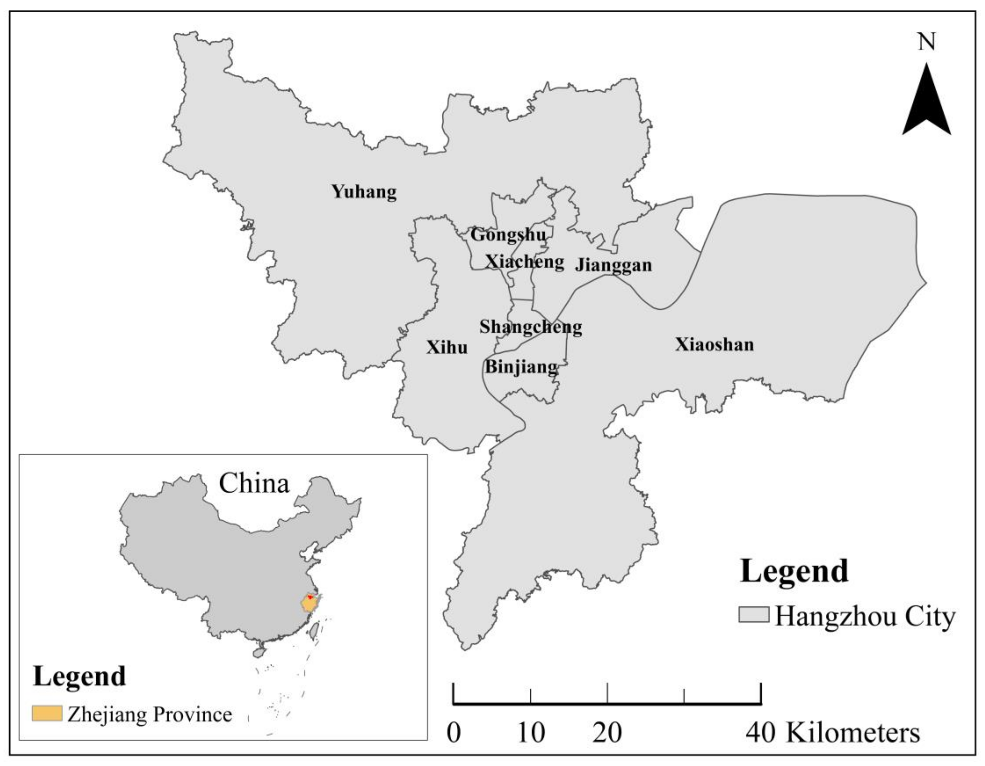
3. Study Area and Data

3.1. Study Drea

Hangzhou was chosen as the study area to test the proposed spatial–temporal–semantic triple analytical framework in this study. In the 13th century, Marco Polo visited Hangzhou and found that it was the most beautiful and luxurious city in the world at that time due to its magnificent scenery and splendid sights. He called Hangzhou a ‘Haven City’, and there was also a street named ‘Haven City Road’ based on the record. Recently, with the rapid development of industry and commerce, Hangzhou has become one of the most energetic and fast-growing cities in China. Because of its gorgeous natural landscape and profound cultural heritage, Hangzhou attracts a large number of tourists to visit it every year. It is not only an important major city with a long history of development in China, but also a modern city bursting with many new opportunities. Therefore, Hangzhou is an ideal city for urban dynamics development study.
Hangzhou, geographically located on the south coast of China (Figure 1), includes eight administrative districts: Shangcheng District, Xiacheng District, Xihu District, Gongshu District, Jianggan District, Binjiang District, Xiaoshan District, and Yuhang District.

3.2. Data

The street name textual information was extracted from Hangzhou Gazetteer [48] compiled by Hangzhou Civil Affairs Bureau and Hangzhou Toponymy Committee, which collects detailed historical documents and records of toponyms in Hangzhou. Based on this data source, we sorted out a total of 3717 pieces of street name information, including the street names, naming reason, naming date, and history of the name changes.
OpenStreetMap provides the current road network data as line vector data for the public, including streets’ spatial geometry information, streets’ names, and streets’ types. By matching street names from the aforementioned two sources, the current street data were associated with the semantic textual information. Finally, a spatial dataset with 903 streets having name history was obtained by further processing data from the aforementioned two sources. The street naming dates span from the Song dynasty (A.D. 960 to A.D. 1279) to 2010. The street names reflect both the city’s historical and current cultures and era characteristics.
Based on the original naming date of the collected street name data and the unique characteristics of the era, we divided the study period into eight time periods (as shown in Table 1): the Qing dynasty and before period, the Republic of China and the Sino-Japanese War period, the liberation war period, the early days of the People’s Republic of China period, the turbulent development period of the People’s Republic of China, the reform and opening-up period of the People’s Republic of China, the rapid urban sprawl period of the People’s Republic of China, and the new millennium development period of the People’s Republic of China. From the time period name, it can be seen that the background of each time period is different from each other. Each time period was separated by an important historical event, such as the founding of the Republic of China, the end of the Second Sino-Japanese War, the founding of the People’s Republic of China, the Cultural Revolution, Reform and Open, and the Millennium.

4. Methodology

This study proposes a novel spatial–temporal–semantic analytical framework to describe urban dynamics from perspectives of time, space, and semantics using street names. Firstly, a classification model suitable for street name short text was developed by taking the word segmentation characteristics of Chinese short text into account. Secondly, spatial visualization and quantitative analysis of street name data with different types from different time periods were carried out by using geographical analysis methods. The spatial and temporal distribution characteristics and semantic information of street names were revealed by means of exploration analysis and pattern recognition, so as to excavate the urban dynamics characteristics and track its development history.

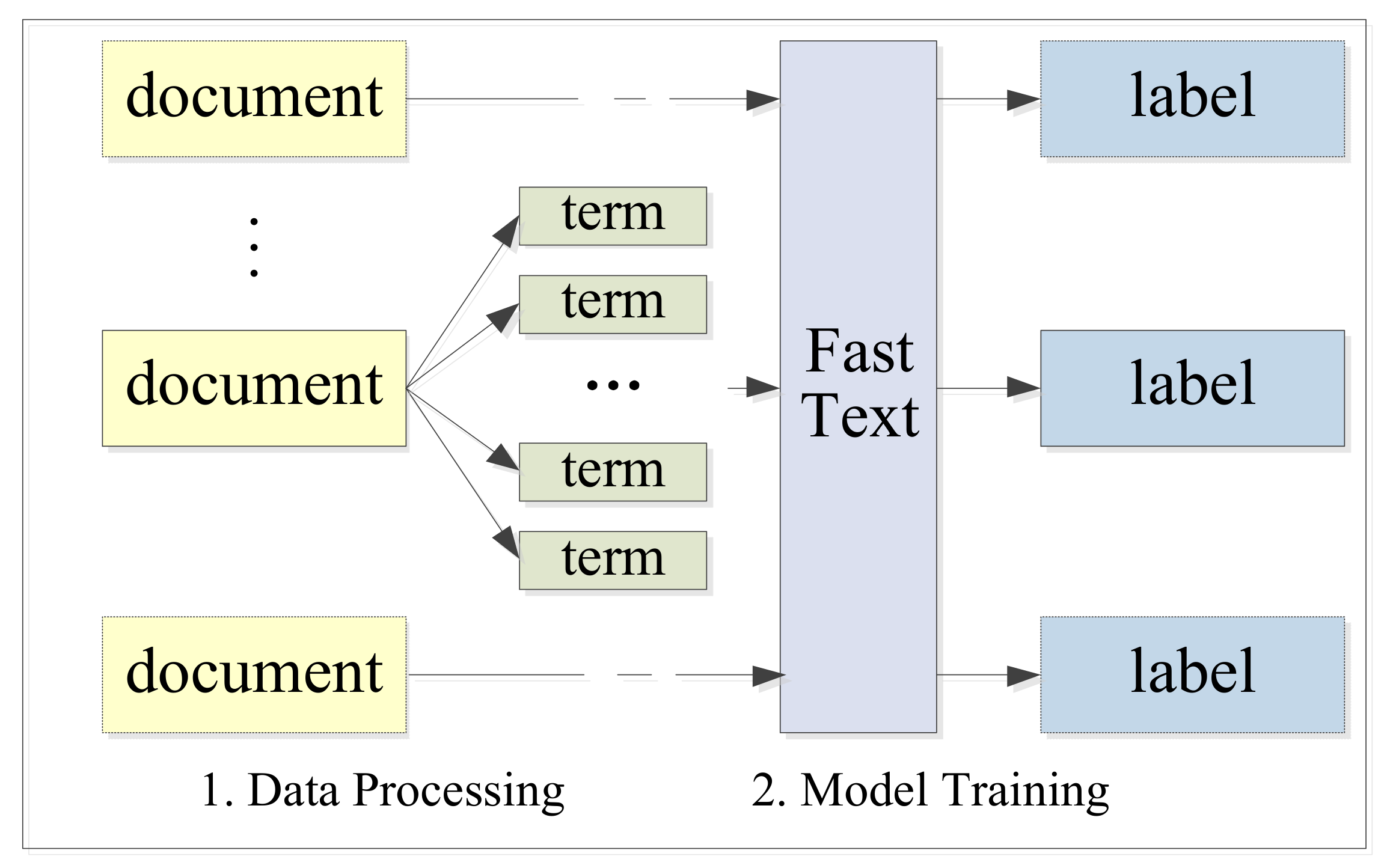
4.1. Street Name Classification Model

A street name usually consists of 3–10 characters. The number of characters for naming reasons varies from dozens to hundreds. Compared with most of the sample data in text mining, the length of the street name text is relatively short. Because of the concise expression, the street name text is sparse and irregular and contains fewer features, which brings great difficulty to classification. Normally, researchers and technicians improve the classification accuracy by optimizing text representation and classifier construction. In recent years, FastText [49,50,51], a text classifier based on word2vec launched by Facebook in 2016, has been widely used in short text classification of Chinese [52] and English [53,54] due to its fast and efficient performance. In some Chinese short text classification examples, the performance of FastText is better than that of deep learning [55]. The FastText model is a shallow network model, which consists of an input layer, a hidden layer, and an output layer. The input layer contains the terms and their n-gram features in the document, which are mapped as embedded words. The FastText model introduces the n-gram feature, and it slides the document content into n-size window according to byte/character order. Finally, it forms n-size byte segment sequence, enriches the feature terms outside the training dictionary, and considers the sequenced relationship of bytes or characters.
In order to improve the classification accuracy, we optimized the classification process in this study. For short text mining, concise language, few terms, and low term frequency usually lead to a great challenge in making full use of the hidden information in the text for classification. We segmented the Chinese text using different segmentation methods. With the application of n-gram, we obtained phrases and features of terms by n-size slide window. The process for street name text classification is shown in Figure 2.
By adjusting the way of word segmentation and the parameters such as n-gram, number of iterations, and learning rate, the model with the best classification results was obtained.

4.2. Kernel Density Estimation

Density analysis is often used to explore distribution patterns of geographical entities, and kernel density estimation is one of the frequently used methods. The kernel density estimation method based on line features can calculate the density of linear elements in the neighborhood of each output grid pixel. Conceptually, each line is covered with a smooth surface. The largest value is located at the position of the line, and the values decrease as the distances from the line increase. The value is zero at the position where the distance from the line is equal to the specified search radius. The density of each output grid pixel is the sum of all of the core surface values superimposed on the center of the grid pixel. The kernel function for linear density calculation is shown in Equation (1).
D ensity = 1 r 2 i = 1 n 3 π * ( 1 - ( d i s t i r ) 2 ) 2 for   d i s t i < r ,   i = 1 , 2 , 3 , , n
where r is the search radius for calculating the kernel density at the current position, i is the serial number of the point within the distance r from the current position, and d i s t i is the distance between point i and the current position.

4.3. Featured Functional Area Aggregation

Street names are usually related to the surrounding geographical entities, so they usually imply local characteristics and development preferences. Therefore, the aggregation area of specific types of street names may reflect the function and development orientation of a region. The regional aggregation based on the main types of street names may help to quickly find out the core areas and characteristic functions of a city. We designed a three-step process to obtain the featured functional areas (Figure 3). We compared the featured functional areas with the development status of Hangzhou city to verify the effectiveness of the regional aggregation. The implementation steps of the regional aggregation are as follows.
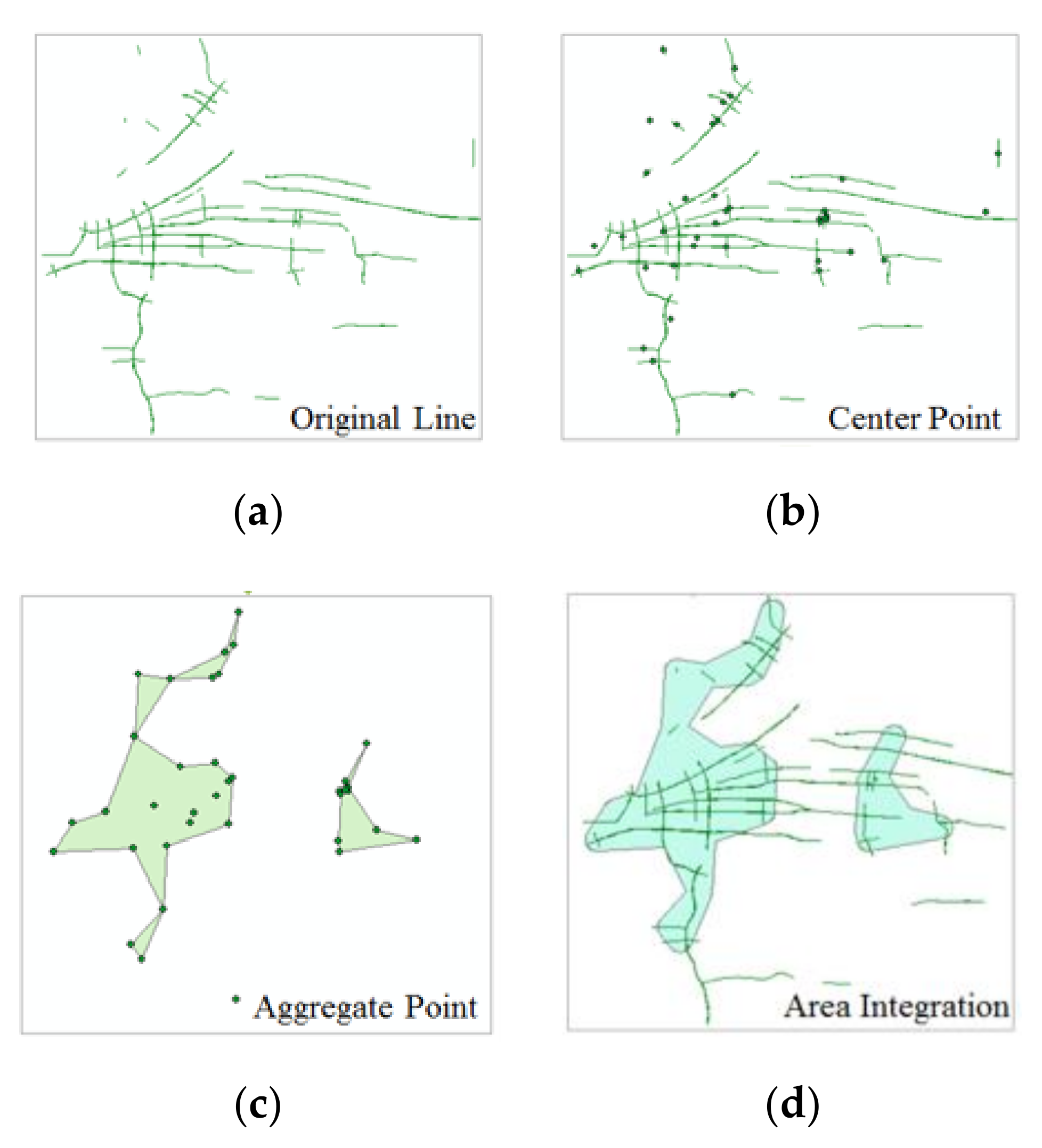
  • The center points were extracted from the original street name data organized by line vector.
  • The street center points were obtained by using an Aggregate Points Tool with a specific threshold. The experiments found that the threshold value of 3500 meters is appropriate for aggregation of the main categories of the street names. The aggregation results are not too scattered or continuous using this threshold value.
  • The aggregation areas were adjusted by buffer. Due to different lengths and shapes of the streets, the point aggregation areas in step 2 could not fully reflect the spatial aggregation status of the same type of street name data. Therefore, we modified the aggregation areas. Taking half of the average length of one type of street name data as the radius, the results from step 2 were analyzed using a buffer in the third step, and the areas intersected by the space were combined in this step. Then, the combined feature areas were finally gathered as featured functional areas.
Figure 3 illustrates an example of the workflow of gathering featured functional areas. The green lines in Figure 3a represent the street name data with naming information. The points in Figure 3b were extracted from the lines, and one point corresponds to one street name datum. The center points were transferred into areas through an aggregation tool. Based on the inherent length attribute of the streets, the shapes of the aggregation areas in Figure 3c were adjusted to make them more consistent with the obtained forms of line features.

5. Results

5.1. Classification Results of Street Name Data

Similar to many other Chinese cities with a long history, Hangzhou’s urban culture is rich and has different characteristics. Based on the actual natural and cultural background of Hangzhou and classification standards from other studies [42,56,57,58], we classified street names into two categories: nature-driven and society-driven. Through a more detailed semantic division, the two categories were further divided into 31 types: mountain, water, scenery, residential area, administrative area, industry, culture and education, and so on (Table 2). In total, 3717 pieces of street name text data were collected in this experiment, and the number of each type is unevenly distributed.
Firstly, the irrelevant descriptions were removed during the preprocessing stage. To obtain a better classification result, we adopted four different word segmentation methods to cut the street name text, including exact mode, full mode and search engine mode in Jieba participle tool, and single char mode. Then, the segmented data were classified by the FastText model. The parameter sensitivity analysis results (Figure 4) show that a relatively accurate classification result was obtained when we cut text into a single char and took n-gram as 2, the learning rate as 1, and the iterations as 14. The overall classification accuracy was represented by three indexes with P = 0.699, R = 0.699, and F-measure = 0.699.
Due to the lack of text data, it is difficult for the model to learn enough effective features to classify some street name types accurately. However, it is not necessary to pay attention to such data because they are not representative in describing urban characteristics due to the scarcity of data. Table 3 lists the classification accuracy of common street name types.
From Table 3, it can be seen that the classification accuracy of 18 street name types is more than 60%, and these types of data account for 87% of the total street name data. Among them, the classification accuracy of digit, non-adjacent water, political motivations, bridge, non-adjacent administrative area, sports, and wish street name types reached more than 80%. Due to the obvious feature words contained in the content of these street name types, the classification results are more accurate than others. These results showed that the FastText model is good at short text classification even without many input data.

5.2. How Street Name Types Change Over Time

We selected the top six street name types in each time period and analyzed the similarities and differences of street name types from different time periods. We explored the characteristics of street name change, road network structure, and urban development through the entire study time period. The total proportion of selected street names is higher than 50% of all street name data in each time period.

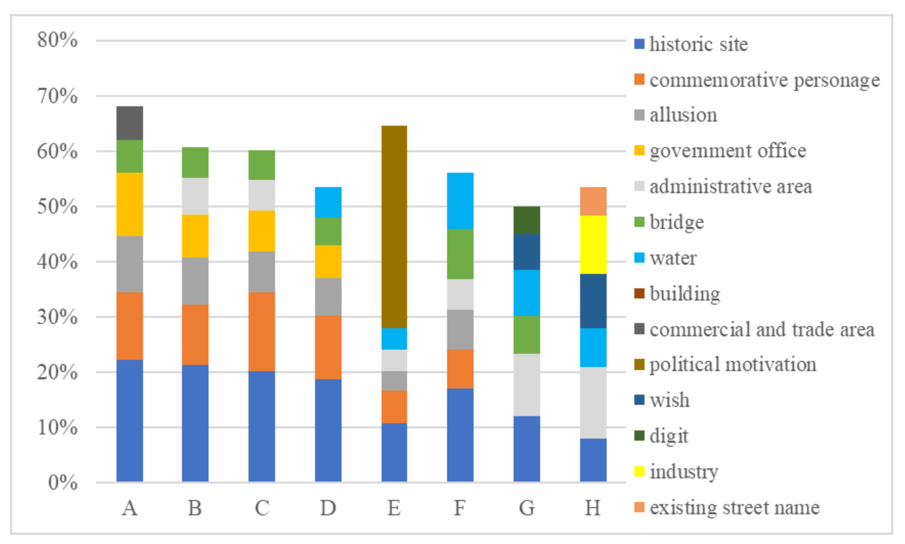
5.2.1. The Similarities of Street Names in all Time Periods—The Base Culture of the City

The proportion of different street name types in each time period is shown in the form of a segmented bar chart (Figure 5). From Figure 5, it can be seen that historic site is the most common street name type in all time periods, accounting for a relatively high proportion. Besides, the type of commemorative personage accounted for a large proportion of Hangzhou street names before 1990 but declined rapidly in time periods G and H. In addition, the number of streets named by allusion and administrative area also has a relatively high proportion in most time periods. It is worth noting that water and bridge are two main street name types that imply the natural characteristics of the city, i.e., the wide distribution of rivers and lakes. The historic site, commemorative personage, and allusion types reflect that city has many monuments and profound cultural heritage.

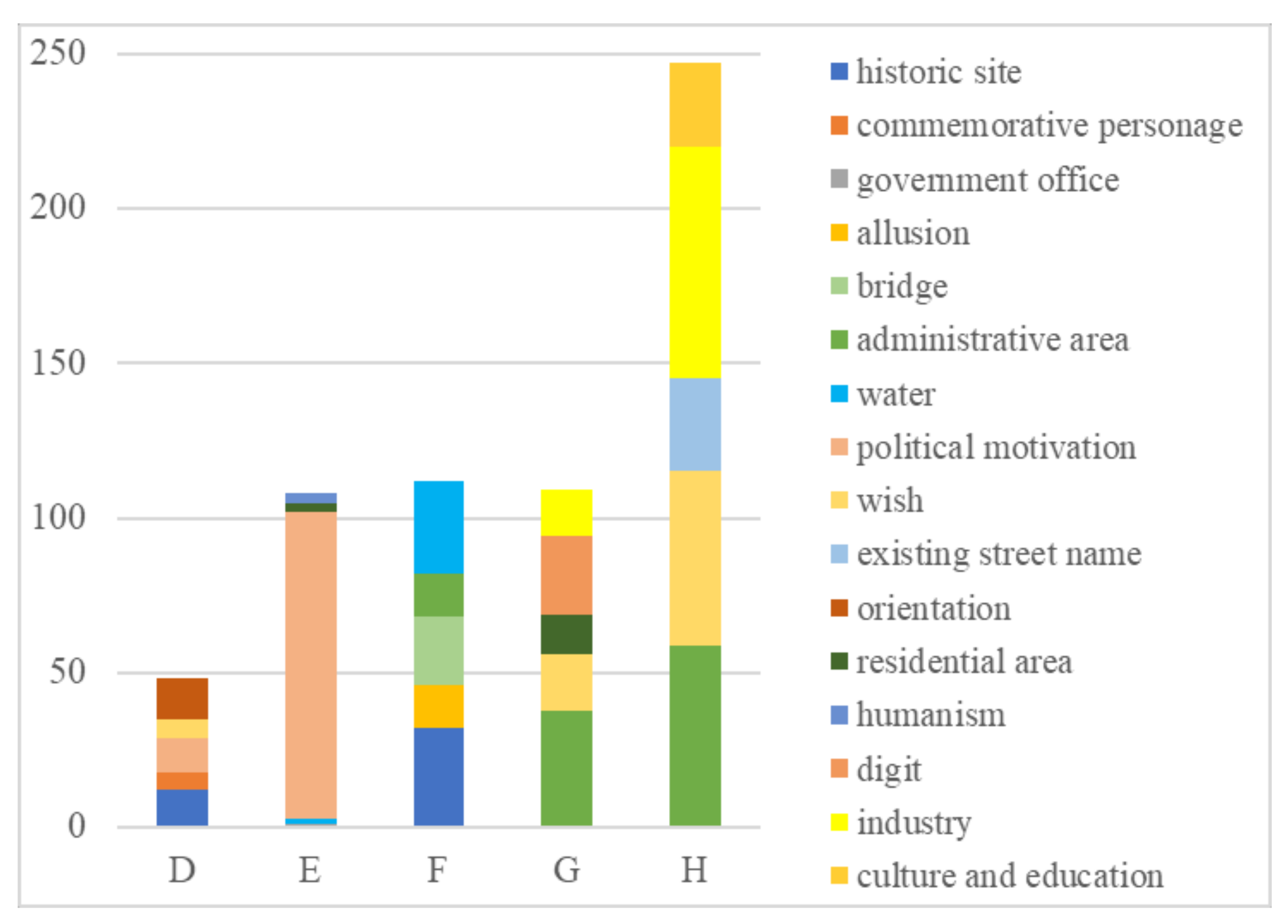
5.2.2. The Differences of Street Names in Each Time Period—The Development Routine of the City

By comparing the main street name types in each time period (Figure 5), it can be seen that the main street name types during the first four time periods, A, B, C, and D, are relatively similar, mainly reflecting the natural environment and historical culture, such as historical site, commemorative personage, government office, allusion, and bridge. The streets named by commercial and trade area have a significant proportion in time period A. This indicates that commercial industry was widely developed in Hangzhou a long time ago (during the feudal society time period). In time period E, influenced by the social environment at that time, there is a notable increase in the streets named by political motivations, which means that the people’s attention was focused more on political activities. In time period F, the main street name types are quite different from those in the previous time periods, and the proportions of historic site, water, and bridge type increased. The street names affected by politics in time period E gradually reappear, resulting in a significant change in the proportions of street name types. In time periods G and H, there are new changes in the main street name types. With the increase in roads, the proportion of streets named by historic site and commemorative personage gradually decreased, but the proportion of streets named by wish increased. This indicates the urgent need for economic development and people’s desire for a better life. The changes in the proportion of street name types during these two time periods indicate that the focus of Hangzhou’s urban development had shifted to economic development without ignoring the relevance to nature. Compared with other time periods, the proportion of streets named by digit is more obvious in time period G, when the society lost its cultural carrying capacity. In time period H, the number of streets and the proportion of streets named after wish, industry, and the existing street name gradually increase. This indicates fast urban expansion and road network upgrades during time period H. The whole cognition of Hangzhou through toponyms is similar to that found in Zheng Qiao’s study [58]. However, the understanding of urban features in this paper is more detailed than the previous study.
Through diachronic and synchronic analyses of toponyms, we can see that street names have both regional and epochal characteristics. The main street names of Hangzhou in the early days were dominated by historical culture and natural landscape. Street names reflect the subjective will of human beings for the city reform during the modern urbanization time period. In other words, the semantic information of the street names can not only reflect the inherent core characteristics of the city, but also capture the social background in urban development.

5.3. Spatial Distribution Characteristics of Street Names

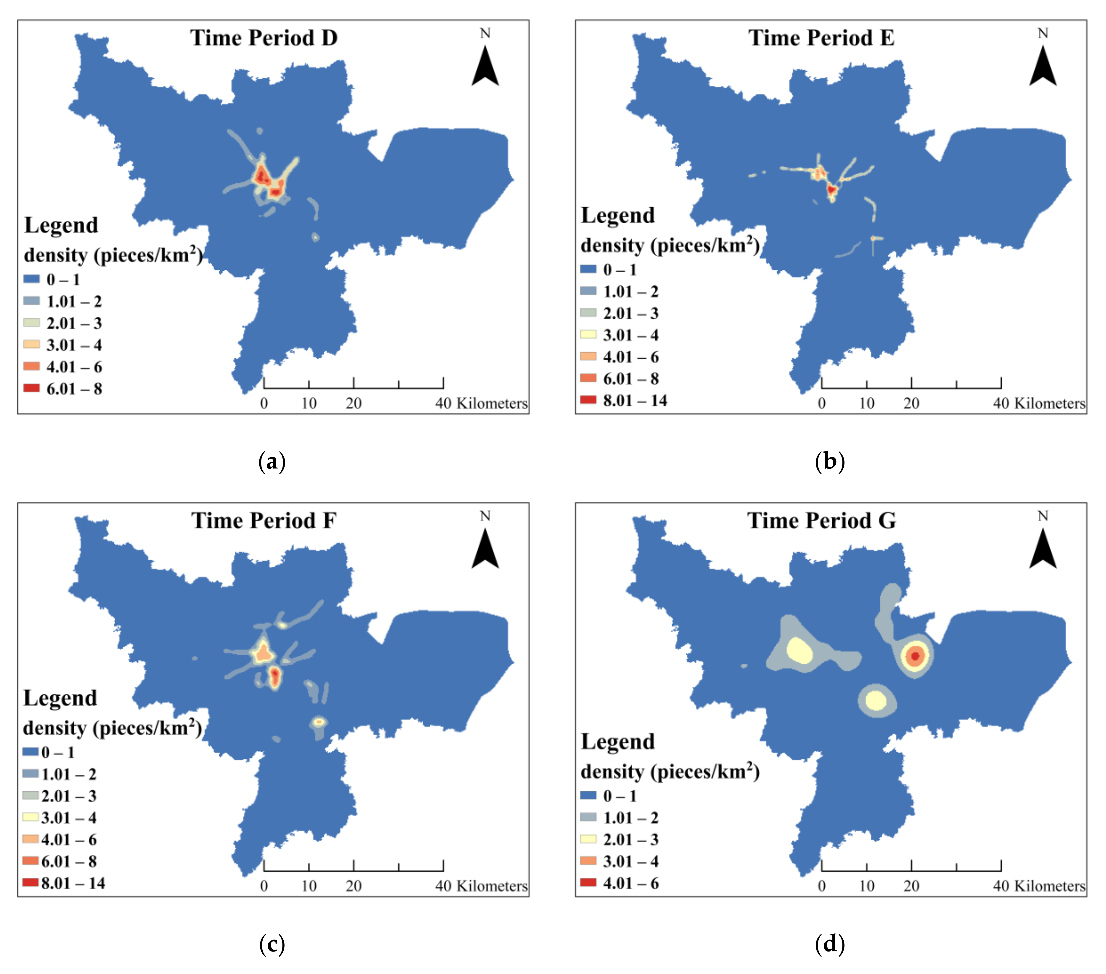
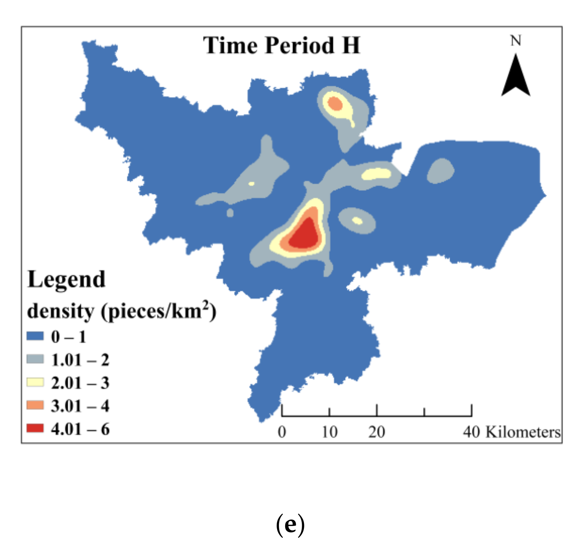
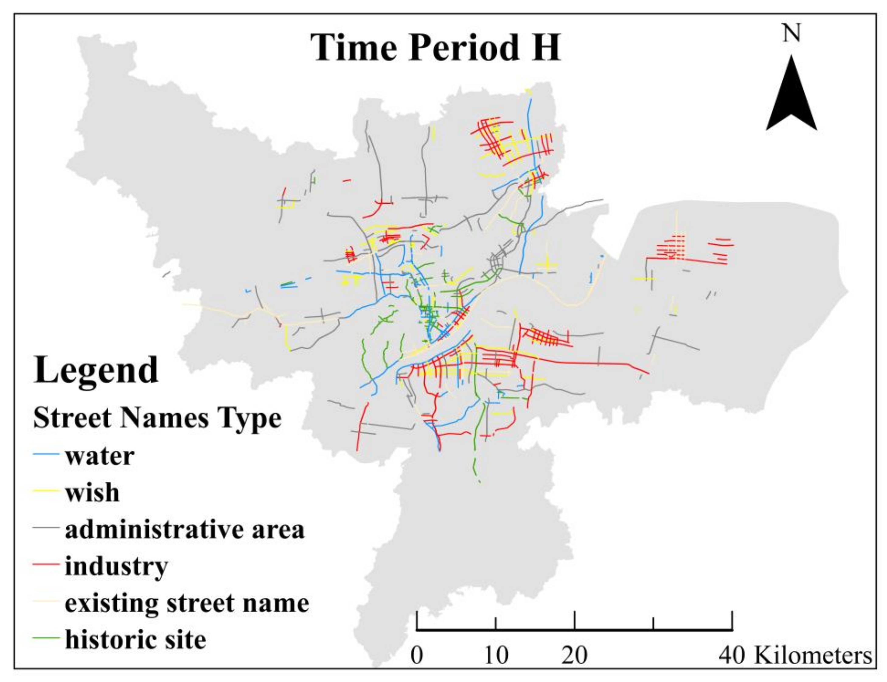
5.3.1. The Spatial Distribution Characteristics of Changed Street Names in Each Time Period

Density analysis is a widely-used method to visualize the distribution patterns of toponyms [42,59]. We exploited the kernel density estimation method to analyze the spatial distribution characteristics of changed street names during the time periods after the founding of the People’s Republic of China. The changed street names are divided into the new-emerging street names and the modified street names. The spatial distributions of the density of the changed street names in each time period are shown in Figure 6.
With the passage of time, the spatial characteristics of changed street names present two obvious characteristics. The changed street names continued to expand to the periphery of the city from the old urban zone. With the expansion of the changed street names, the density peak area appears in the suburban zones. However, the density values are obviously reduced compared with the old urban zones. This reflects that urbanization has changed from the tight and dense mode to the extensive and sparse mode. Combined with the types of changed street names (Figure 7), we analyzed the focus locations of road construction and urban sprawl in the time periods D–H.
The changed street names in time period D are mainly distributed in the old urban zone, including Shangcheng District, Xiacheng District, and Xihu District, with a maximum density of 7 pieces/km2. The main types of street names in this time period are orientation, historic site, political motivation, commemorative personage, and culture and education. The People’s Republic of China was founded in this time period. The information reflected by street names not only includes the commemoration of the epoch-making events, but also the situation of Hangzhou where a thousand things waited to be done. Combined with the emergence of the culture and education street name type, we can find that Hangzhou played an important role in the development of cultural industry. In addition, the orientation type, which is frequently used in other well-planned and formal cities such as Beijing, indicates that Hangzhou’s urban development was planned well.
Most of the changed street names in time period E are distributed in the old urban area, but there are also a few in the suburban area, with the highest density of 12 pieces/km2. During this time period, most of the changed street names were modified based on the original street names influenced by politics. Toponyms are usually understood as power-embedded representation over urban spaces. By naming places, specific political ideology was powerfully rendered, so toponyms may be used for the ruling socio-political order [39]. Motivated by political events, many streets were given names with new meanings. Combined with the main types of changed street names, street name data indirectly reflect the societal and cultural changes of the city.
Many street names changed due to political influence in time period E were recovered in time period F, so its overall distribution of street name data is similar to that of the previous time period. In this time period, the highest density of street names is nearly 9 pieces/km2. The difference is that there is a small peak area in Xiaoshan District. The major types of changed street names include historic site, water, bridge, allusions, and administrative area. The main reason for the change of street names during time period F was to repair the local culture changed or damaged in time period E. In general, the aforementioned five types of street names account for a majority of street names in Hangzhou, so they also became the major types in street name recovery.
Time period G is a rapid development time period, in which the spatial distributions of changed street names were no longer limited to the old urban zones, but gradually spread into suburban zones, such as Xiaoshan District, Xiasha area, and the junction of Xihu District and Gongshu District. Figure 6 (time period G) shows multiple high peak areas. The peak values of the region are not as high as those in other time periods, and the coverage of the areas with high values is obviously enlarged. The density of changed street names near the old urban center is relatively lower than that in the suburban zones. In terms of changed street name types, time period G is quite different from other time periods, with types such as administrative area, digit, wish, industry, and residential area. The characteristics of naming administrative area by using toponyms are similar to those in Shanghai, mostly for the convenience of memorizing. During the rapid urban sprawl time period, the number of streets in need of naming increased rapidly. While the use of other toponyms to name new streets is fast and effective, this implies the lack of cultural carrying capacity.
The spatial distribution of changed street names in time period H is more extensive than those of the previous time periods. In Binjiang District and Yuhang District, there are dense distribution areas. Almost the whole Binjiang District is located in the high peak area, with the highest density of nearly 5 pieces/km2. The main types of changed street names include industry, administrative area, wish, existing street name, and culture and education. In this time period, construction orientation in Hangzhou obviously shows a strong desire for economic development. The changed street name types also reflect the rapid development of the science and technology industry. The increase in the number of industry type street names indicates that Hangzhou has entered a new stage of industry development. The urban vitality center is transferring from landscape and culture to economy and technology, and the development direction of the city is also becoming diversified. Considering the patterns of street name changes in the different time periods, it can be seen that the economic and technological development in Hangzhou was not achieved overnight, but gradually formed through certain cultural and industrial accumulation.

5.3.2. The Spatial Distribution Characteristics of All Street Names in the Latest Time Period

Taking street names in time period H as an example, we explored the spatial distribution characteristics of street names in the new millennium. Through kernel density estimation of all street names in this time period (Figure 8), it can be found that there are four obvious density peak areas in Hangzhou, namely the old urban zone near the lake (A), the urban zone around the canal (B), Binjiang high-tech zone (C), and Xiasha university zone (D). The areas with a high density of street names in Hangzhou can be divided into two types: the old urban zone with rich history and the new developing technological zone. From Figure 8, it can be seen that the density of street names in the old urban areas near the lake is the highest where residential areas, commercial areas, and scenic spots are densely distributed. Zone B is close to the canal, with a large number of residential areas and schools. Zone C has high-tech industries and has gradually developed into the city’s suburban center. Xiasha zone (zone D) is equipped with the university town, science and technology parks, and other facilities.

5.4. Understanding the City from Place to Location with Semantics

Using a geographical analysis method and a featured functional area aggregation process, the spatial characteristics of the city reflected by the street names were refined and located. We made a more detailed analysis of the city’s cognition from a whole city to a specific location with semantics.

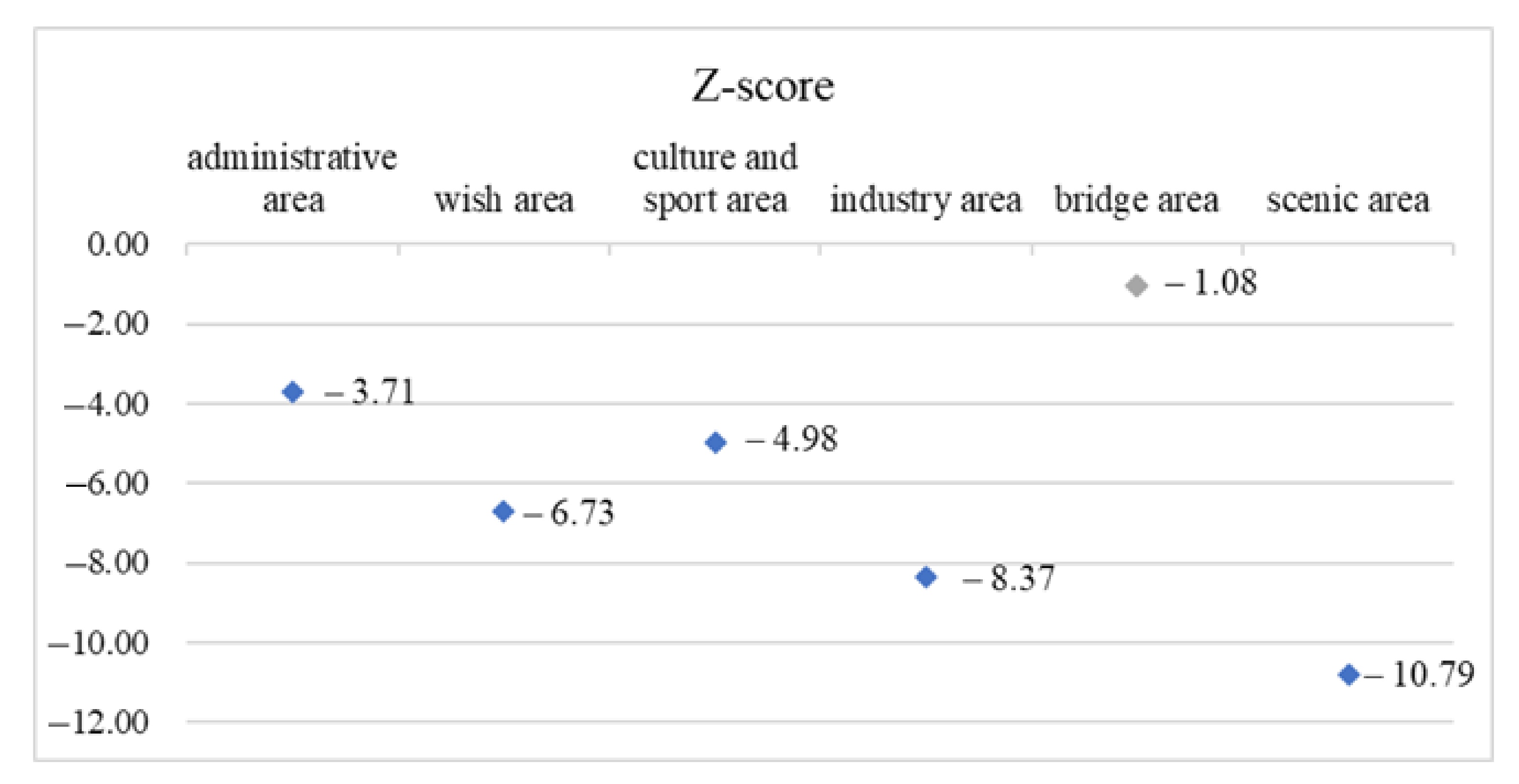
5.4.1. Spatial Distribution Characteristics of Street Names with Different Types

The main street name types include administrative area, wish, industry, historic site, water, and existing street name, accounting for 12.3%, 11.3%, 9.5%, 7.6%, 7.0%, and 5.1%, respectively. These different types of street names are marked with different colors as shown in Figure 9. Street names of these types generally are scattered across the city. The majority of streets named by wish are distributed in the suburban areas, while only very few are located in the center of the city. The streets named by historic site are mostly distributed in the central urban area and the West Lake area. Most of the streets named by water are located along the river.
The types with similar semantics were selected and summarized into six categories, namely administrative area, scenic area, industry area, culture and sport area, bridge area, and wish area, as shown in Table 4. They include 550 pieces of street name data, accounting for 62.5% of the total data.
We explored the distribution patterns of the six categories’ street names by average nearest neighbor analysis. The results show that the Z-scores of other categories except bridge area are less than −3 (Figure 10). This indicates that street names of these five categories have significant spatial clustering patterns. The spatial distribution of street names with bridge type tends to be a random pattern. Considering the actual situation, most of the streets named by bridge are distributed along the canal and river. Therefore, in terms of spatial distribution, there is no obvious spatial distribution pattern in bridge aggregation areas.

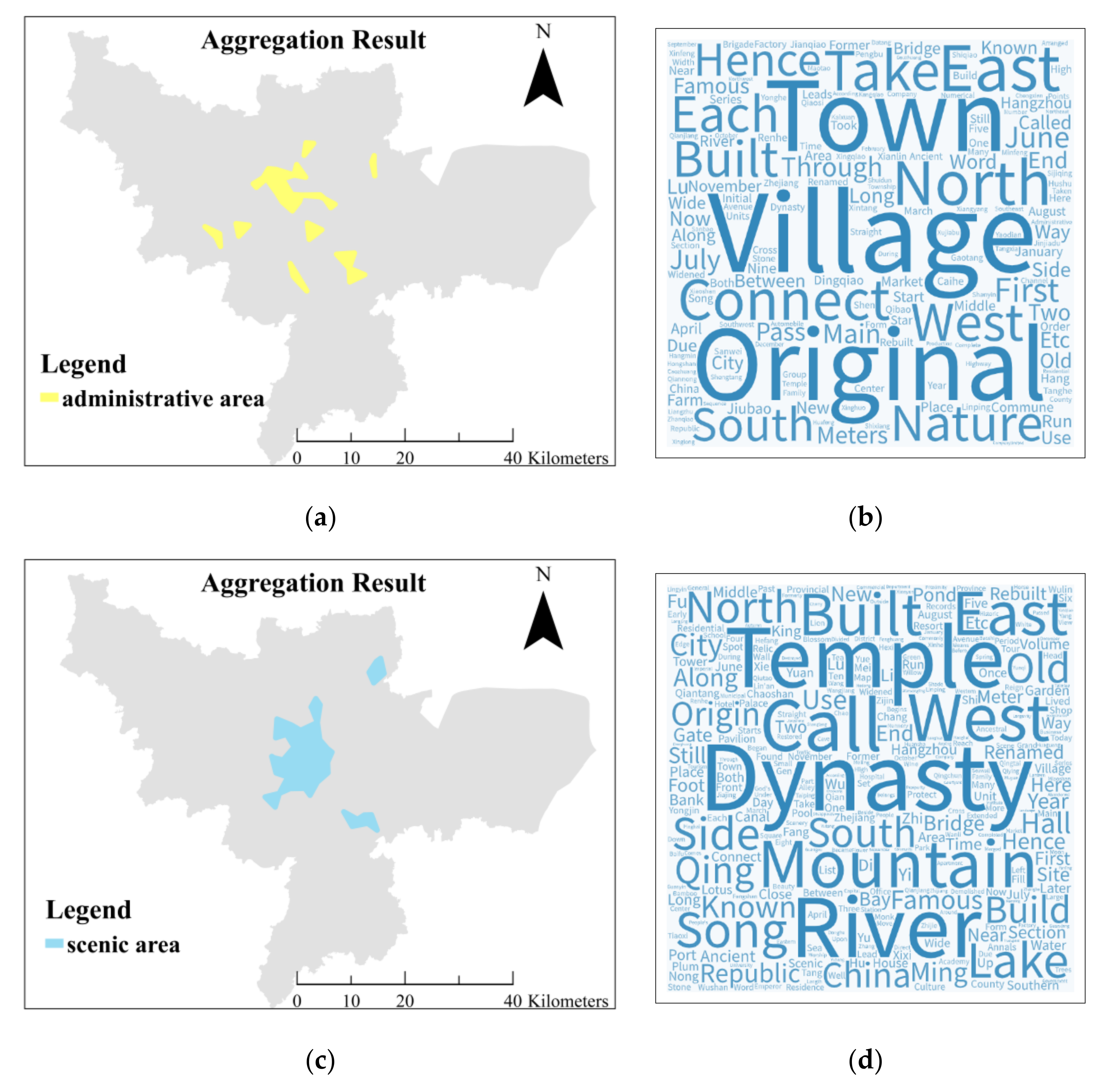
5.4.2. Featured Functional Area Aggregation Results

Based on the computed results of spatial distribution mode, we selected five categories of street names with significant spatial clustering characteristics to obtain featured functional areas using the aggregation workflow. Figure 11 shows the spatial aggregation results and the corresponding distributions of word frequencies for administrative area, scenic area, industry area, culture and sport area, and wish area.
Based on the master plan of Hangzhou city (2001–2020), as shown in Figure 12, and the field survey data regarding construction conditions, it can be found that the aggregated administrative areas are mostly located at the junctions of administrative districts.
The aggregation zones of scenic areas are mainly distributed in West Lake, Xiang Lake, Banshan scenic area, Linping Lake, and downtown area. Typical street names include West Lake reach and Xiang Lake road. The most frequently used words in this category of street names are dynasty, river, temple, mountain, and lake, which reflects that the street names contain both the meaning of natural scenery and human sites.
The aggregation zones of industry areas are located mainly in Binjiang District, Xiaoshan District, and Yuhang District. The spatial aggregation results extract the main industrial parks in Hangzhou, such as Binjiang industrial zone (A), Dajiangdong industrial zone (B), Xiaoshan economic and technological development zone (C), Yuhang industrial zone (D), and Xiangfu industrial zone (E). Through the word cloud chart, we can see that industry, park, and high-tech are common words in street name text. High-frequency words can reflect that the industrial development direction of Hangzhou is more focused on the fields of science and technology, which are different from labor-intensive industry and resource-intensive industry. The development of the high-tech industry means that there are abundant personnel, scientific, and educational resources available from the government to support its development.
In terms of the culture and sport area category, two zones are found through spatial aggregation: the education park in Xihu District and the Xiasha university town. The former includes Zhejiang University, Zhejiang Business University, Zhejiang University of Finance and Economics, Xuejun middle school, Hangzhou gymnasium, and other places. The latter includes Hangzhou University of Electronic Science and Technology, Zhejiang University of Technology, and China University of Metrology. In this category of street name text, the common words mainly include Zhejiang, primary, school, culture, and university. The support for education has played an important role in the development of the high-tech industry in Hangzhou.
Figure 11 also shows the five pieces of the wish aggregation area, which are mainly distributed in the downtown area, Yuhang industrial park, Xiangfu industrial area, and the canal bank. Typical street names include Benefit People road and Safe road in the old urban areas, and Luck road in the new development areas. We extracted the frequent words such as new, prosper, people, peace, develop, and rich by excluding the words that appear more but with less meaning. These street names have common characteristics, bearing the wishes and expectations of the local communities for future development. Therefore, the spatial aggregation zones are mostly concentrated in areas with better economic development conditions.
The aggregation method of featured functional area proposed in this paper can determine the key functional areas of a city from space, which may help to realize more refined urban cognition from a place to a specific location. Street names, therefore, may serve as useful auxiliary data in other related studies such as in functional zone identification studies.

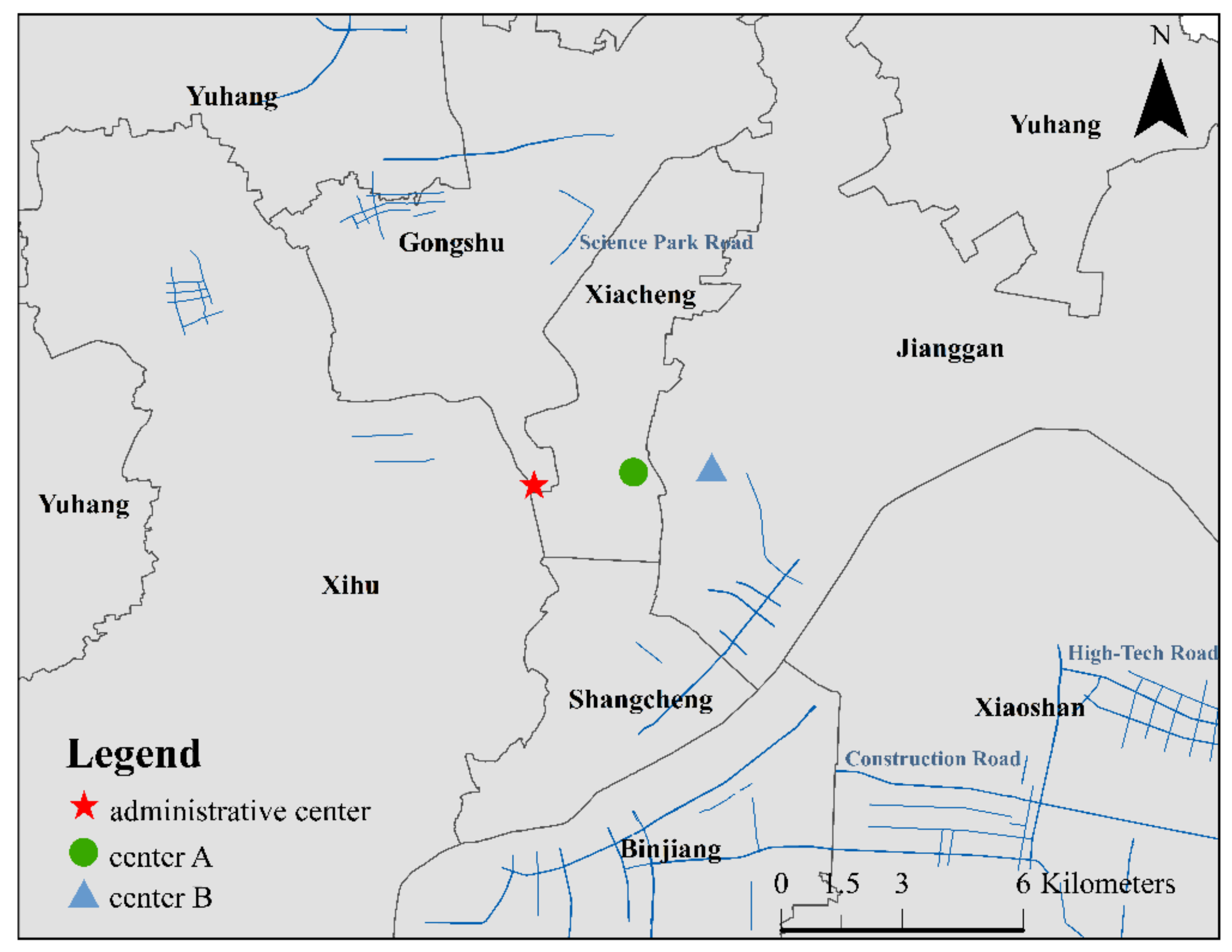
5.4.3. Discovering City Centers through Street Name Data

The aforementioned five categories of spatial aggregation results include the key areas in the process of urban development of Hangzhou. The spatial distributions of these regions indicate that the spatial preference of urban growth may surround the urban centers. The density of road networks and nodes was used to generate the main center area in the literature [60]. Inspired by this, we united these aggregation areas to extract the gravity center of Hangzhou. The identified center results suggest that the straight-line distance between the administrative center of Hangzhou municipal government in 2010 and the center based on all categories of aggregation areas is about 4.5 km (Figure 13, center B). In addition, considering that Hangzhou is not a traditional industrial city from the perspective of urban planning, we eliminated industrial areas and re-extracted the gravity center. The re-extracted center results show that there is less deviation between the administrative center and the center based on the union of administrative area, wish area, culture and sport area, and scenic area. The straight-line distance is only 2.5 km (Figure 13, center A).
The above results verify the urban orientation of Hangzhou. That is, industry is not the only pillar trade, and Hangzhou is a comprehensive city integrating natural scenery, culture, education, and economy.

6. Discussion

6.1. The Limitation of Street Name Semantic Classification Standard in Research Regions

We classified the street names into two categories: nature-driven class and society-driven class. This distinction is constantly recognized in the linguistic theory of toponymy [61]. In order to make full use of the semantic connotation of the street names, these two categories need to be divided into more detailed subcategories. Based on toponym literature [56,58] and also considering the actual situation of Hangzhou city, we finally identified 31 subcategories of street names. There are few standards about street name classification. Different from broad toponym types, street naming reasons are complicated and cannot be unified among different regions. They may be universal in some regions with similar history and culture but are probably diverse in other regions differing in history and culture. The street name semantic types identified in this study may not be fully applicable to Western countries. This depends on the local development background. However, this study provides a novel idea and a feasible practice to explore urban dynamics characteristics by using toponyms.

6.2. The Accuracy of Urban Space Recognition Based on Street Names

Toponyms can represent the specific geographical space and spatial entities [46]. Based on this concept, we proposed a featured functional area aggregation workflow to recognize the interesting areas in urban space. The aggregation results reflect the main development directions, important locations, and industries of Hangzhou city. The aim of this study was not to try to clearly associate a particular place with a specific function or to identify the accurate industrial layout. Through the exploration from place to location, we argue that the spatial–temporal–semantic characteristics of toponyms may be helpful for understanding the dynamic details of a city. The time span and spatial scale of toponyms in this study may be adapted to a multiscale analysis.

7. Conclusions and Future Works

Street names are the product of urban development. A street name may reflect the changing footprint of a city based on its regional and epochal characteristics. With the support of text and spatiotemporal information, the urban dynamics may be explored from the multidimensional views of time, space, and semantics, so as to improve understanding of a city from shallow cognition to in-depth explanation.
This study takes the street name as a new data perspective to tell the story of a city. Under the spatial–temporal–semantic analytical framework, the information implied in street names has been mined thoroughly to extract the urban dynamics characteristics. By classifying the street name data and comparing the distribution of street name types in different time periods, we explained the natural geographical environment and humanity features of Hangzhou city and analyzed its development direction and vitality that changed with time. During the last hundred years, Hangzhou city gradually expanded outwards with diverse development preferences and formed several high-density areas of road network. In this study, we selected the important street names in Hangzhou and aggregated them in space. Based on the aggregation results, the contents of the text were analyzed to find the urban characteristics of Hangzhou. Based on the analysis results, we learned that Hangzhou is a cultural ancient city with historical accumulation and unique natural scenery. As for the orientation of development, Hangzhou is a comprehensive city with various industries, focusing on the development of high-tech industry and tourism. These analysis results are highly consistent with the current urban development plan of Hangzhou. We effectively extracted urban featured functional areas and urban center to reflect the core characteristics of the city based on the semantic features and spatial distribution features of street names.
There are two major new contributions in our study. First, through the combination of n-gram feature and Chinese text segmentation strategy, we obtained highly accurate classification results. We verified the effectiveness of the classification method for the main types of street names. Second, taking the street name data as a new perspective, we proposed a set of methods to explore the urban dynamics characteristics in depth. The results show that the analytical framework proposed in this study can achieve a more objective and in-depth cognition of the urban development background, current situation, and development direction. Compared with the literature driven by remote sensing data or human behavior data [3,4,6,10,19], this study extends the novel third dimension of urban dynamics research. In the related studies on the combination of toponyms and geography, scholars paid more attention to the toponym landscape and analyzed the cultural, economic, and political phenomena behind toponyms [24,27,36,41,58,62]. However, they ignored the combined toponym information from the spatial, temporal, and semantic dimensions. We integrated the spatial–temporal–semantic information of toponyms and exploited it to track the historical urban development process by applying GIS technologies. Such a deep understanding of a city may provide scientific suggestions for urban planning, land use development, and industrial structure layout and design.
It can be seen that street names can be used as valuable data to extract more features of long-term urban dynamics for urban cognition and development. Through the more detailed analysis of featured locations, semantic information is of great significance to the exploration of urban functions. We suggest that semantic information has potential in the identification and recognition of urban functional zones to enlarge the regional differences beyond the temporal and spatial patterns of activities. In terms of visualization, we used the traditional static 2D maps to visualize the characteristics implicated in street name data. In order to reach a wide variety of people at a low cost, web-based interactive maps for the public may be developed in future work. Open access libraries have given much simplicity to web cartography [63,64], and they can also help for better visualization of our research results.

Author Contributions

Conceptualization, Yurong Chen and Feng Zhang; data curation, Yurong Chen; formal analysis, Yurong Chen, Chuanrong Zhang, and Bo Wang; funding acquisition, Ninghua Chen, Zhenhong Du, and Renyi Liu; methodology, Yurong Chen and Feng Zhang; project administration, Feng Zhang; supervision, Feng Zhang and Renyi Liu; writing—original draft, Yurong Chen; writing—review and editing, Feng Zhang, Xinba Li, and Chuanrong Zhang. All authors have read and agreed to the published version of the manuscript.

Funding

This research was funded by the National Key R&D Program of China (2019YFC1521303) and the National Natural Science Foundation of China (41671391,41922043, 41871287).

Data Availability Statement

Publicly available datasets were analyzed in this study. The street name text data presented in this study are openly available in Hangzhou Gazetteer, reference number [48]. The road network data can be found here: http://download.geofabrik.de/asia/china.html.

Acknowledgments

The authors would like to thank the anonymous reviewers of IJGI for their valuable comments that better shaped the paper.

Conflicts of Interest

The authors declare no conflict of interest.

References

  1. Gao, S. Spatio-Temporal Analytics for Exploring Human Mobility Patterns and Urban Dynamics in the Mobile Age. Spat. Cogn. Comput. 2015, 15, 86–114. [Google Scholar] [CrossRef]
  2. Paez, A.; Scott, D.M. Spatial Statistics for Urban Analysis: A Review of Techniques with Examples. GeoJournal 2004, 61, 53–67. [Google Scholar] [CrossRef]
  3. Li, S.; Liu, X.; Li, Z.; Wu, Z.; Yan, Z.; Chen, Y.; Gao, F. Spatial and Temporal Dynamics of Urban Expansion along the Guangzhou–Foshan Inter-City Rail Transit Corridor, China. Sustainability 2018, 10, 593. [Google Scholar] [CrossRef] [Green Version]
  4. Tian, G.; Jiang, J.; Yang, Z.; Zhang, Y. The urban growth, size distribution and spatio-temporal dynamic pattern of the Yangtze River Delta megalopolitan region, China. Ecol. Model. 2011, 222, 865–878. [Google Scholar] [CrossRef]
  5. Zhang, H.; Ning, X.; Shao, Z.; Wang, H. Spatiotemporal Pattern Analysis of China’s Cities Based on High-Resolution Imagery from 2000 to 2015. ISPRS Int. J. Geo-Inf. 2019, 8, 241. [Google Scholar] [CrossRef] [Green Version]
  6. Zhang, M.; Du, H.; Mao, F.; Zhou, G.; Li, X.; Dong, L.; Zheng, J.; Zhu, D.; Liu, H.; Huang, Z.; et al. Spatiotemporal Evolution of Urban Expansion Using Landsat Time Series Data and Assessment of Its Influences on Forests. ISPRS Int. J. Geo-Inf. 2020, 9, 64. [Google Scholar] [CrossRef] [Green Version]
  7. Nassar, A.K.; Blackburn, G.A.; Whyatt, J.D. Developing the desert: The pace and process of urban growth in Dubai. Comput. Environ. Urban Syst. 2014, 45, 50–62. [Google Scholar] [CrossRef] [Green Version]
  8. Taubenböck, H.; Wegmann, M.; Roth, A.; Mehl, H.; Dech, S. Urbanization in India – Spatiotemporal analysis using remote sensing data. Comput. Environ. Urban Syst. 2009, 33, 179–188. [Google Scholar] [CrossRef]
  9. Xiao, H.; Liu, Y.; Li, L.; Yu, Z.; Zhang, X. Spatial Variability of Local Rural Landscape Change under Rapid Urbanization in Eastern China. ISPRS Int. J. Geo-Inf. 2018, 7, 231. [Google Scholar] [CrossRef] [Green Version]
  10. Zhao, M.; Zhou, Y.; Li, X.; Cheng, W.; Zhou, C.; Ma, T.; Li, M.; Huang, K. Mapping urban dynamics (1992–2018) in Southeast Asia using consistent nighttime light data from DMSP and VIIRS. Remote. Sens. Environ. 2020, 248, 111980. [Google Scholar] [CrossRef]
  11. Li, Q.; Lu, L.; Weng, Q.; Xie, Y.; Guo, H. Monitoring Urban Dynamics in the Southeast U.S.A. Using Time-Series DMSP/OLS Nightlight Imagery. Remote. Sens. 2016, 8, 578. [Google Scholar] [CrossRef] [Green Version]
  12. Ma, T.; Zhou, Y.; Zhou, C.; Haynie, S.; Pei, T.; Xu, T. Night-time light derived estimation of spatio-temporal characteristics of urbanization dynamics using DMSP/OLS satellite data. Remote. Sens. Environ. 2015, 158, 453–464. [Google Scholar] [CrossRef]
  13. Zhou, N.; Hubacek, K.; Roberts, M. Analysis of spatial patterns of urban growth across South Asia using DMSP-OLS nighttime lights data. Appl. Geogr. 2015, 63, 292–303. [Google Scholar] [CrossRef]
  14. Chen, X.; Jian, P.; Yanxu, L.; Yunqian, C.; Tianyi, L. Measurement of Urban Spatial Expansion and Spatial Correlation in Beijing Tianjin Hebei Region Based On DMSP/OLS Night Light Data. Geogr. Res. 2018, 37, 54–65. [Google Scholar]
  15. Kim, Y.-L. Data-driven approach to characterize urban vitality: How spatiotemporal context dynamically defines Seoul’s nighttime. Int. J. Geogr. Inf. Sci. 2020, 34, 1235–1256. [Google Scholar] [CrossRef]
  16. Tu, W.; Cao, J.; Yue, Y.; Shaw, S.-L.; Zhou, M.; Wang, Z.; Chang, X.; Xu, Y.; Li, Q. Coupling mobile phone and social media data: A new approach to understanding urban functions and diurnal patterns. Int. J. Geogr. Inf. Sci. 2017, 31, 2331–2358. [Google Scholar] [CrossRef]
  17. Du, Z.; Zhang, X.; Li, W.; Zhang, F.; Liu, R. A multi-modal transportation data-driven approach to identify urban functional zones: An exploration based on Hangzhou City, China. Trans. GIS 2019, 24, 123–141. [Google Scholar] [CrossRef]
  18. Zhang, X.; Li, W.; Zhang, F.; Liu, R.; Du, Z. Identifying Urban Functional Zones Using Public Bicycle Rental Records and Point-of-Interest Data. ISPRS Int. J. Geo-Inf. 2018, 7, 459. [Google Scholar] [CrossRef] [Green Version]
  19. Pei, T.; Sobolevsky, S.; Ratti, C.; Shaw, S.-L.; Li, T.; Zhou, C. A new insight into land use classification based on aggregated mobile phone data. Int. J. Geogr. Inf. Sci. 2014, 28, 1988–2007. [Google Scholar] [CrossRef] [Green Version]
  20. Steiger, E.; Westerholt, R.; Resch, B.; Zipf, A. Twitter as an indicator for whereabouts of people? Correlating Twitter with UK census data. Comput. Environ. Urban Syst. 2015, 54, 255–265. [Google Scholar] [CrossRef]
  21. Chu, Y. Basic Course of Toponymy; Surveying and Mapping Press: Beijing, China, 2009. [Google Scholar]
  22. Hua, L. History of Chinese Place Names; QiLu Press: Jinan, China, 2005. [Google Scholar]
  23. Conedera, M.; Vassere, S.; Neff, C.; Meurer, M.; Krebs, P. Using Toponymy to Reconstruct Past Land Use: A Case Study of ‘Brüsáda’ (Burn) in Southern Switzerland. J. Hist. Geogr. 2007, 33, 729–748. [Google Scholar] [CrossRef]
  24. Wang, Y.; Ge, D.; Zhang, T.; Wang, Y. The Sustainable Development of Choronymic Cultural Landscapes in China Based on Geo-Informatic Tupu. Sustainability 2019, 11, 4302. [Google Scholar] [CrossRef] [Green Version]
  25. Fagúndez, J.; Izco, J. Spatial Analysis of Heath Toponymy in Relation to Present-Day Heathland Distribution. Int. J. Geogr. Inf. Sci. 2016, 30, 51–60. [Google Scholar] [CrossRef]
  26. Wanjiru, M.W.; Matsubara, K. Street toponymy and the decolonisation of the urban landscape in post-colonial Nairobi. J. Cult. Geogr. 2017, 34, 1–23. [Google Scholar] [CrossRef]
  27. Light, D.; Nicolae, I.; Suditu, B. Toponymy and the Communist city: Street names in Bucharest, 1948–1965. GeoJournal 2002, 56, 135–144. [Google Scholar] [CrossRef]
  28. Basik, S. Urban Place Names: Introduction. Urban Sci. 2020, 4, 80. [Google Scholar] [CrossRef]
  29. Hough, C. The Oxford Handbook of Names and Naming; Oxford University Press: Oxford, UK, 2016. [Google Scholar]
  30. Jett, S.C. Place-Naming, Environment, and Perception Among the Canyon De Chelly Navajo of Arizona. Prof. Geogr. 1997, 49, 481–493. [Google Scholar] [CrossRef]
  31. Campbell, J.C. Stream Generic Terms as Indicators of Historical Settlement Patterns. Names J. Onomast. 1991, 39, 333–365. [Google Scholar] [CrossRef]
  32. Freitas, L.; Afonso, M.J.; Devy-Vareta, N.; Marques, J.M.; Gomes, A.; Chamine, H.I. Coupling Hydrotoponymy and GIS Cartography: A Case Study of Hydrohistorical Issues in Urban Groundwater Systems, Porto, NW Portugal. Geogr. Res. 2014, 52, 182–197. [Google Scholar] [CrossRef]
  33. Hudson, B.J. The Naming of Waterfalls. Geogr. Res. 2013, 51, 85–93. [Google Scholar] [CrossRef]
  34. Kitson, P.R. British and European River-Names. Trans. Philol. Soc. 1996, 94, 73–118. [Google Scholar] [CrossRef]
  35. Nicolae, I. Camino De Santiago: Place Names and Street Names as Border Posts in the Collective Memory. Human Geogr. 2010, 41, 17–31. [Google Scholar]
  36. Villette, J.; Purves, R.S. From Microtoponyms to Landscape Using Semantics, Location, and Topography: The Case of Wald, Holz, Riet, and Moos in St. Gallen, Switzerland. Prof. Geogr. 2020, 72, 109–120. [Google Scholar] [CrossRef] [Green Version]
  37. Zhong, A.; Wu, Y.; Nie, K.; Kang, M. Using Local Toponyms to Reconstruct the Historical River Networks in Hubei Province, China. ISPRS Int. J. Geo-Inf. 2020, 9, 318. [Google Scholar] [CrossRef]
  38. Situ, S.J. Historical Geography Study of Toponyms of Guangdong Province. Essays Chin. Hist. Geogr. 1992, 1, 21–55. [Google Scholar]
  39. Berg, L.D.; Vuolteenaho, J. Towards Critical Toponymies; Ashgate: Aldershot, UK, 2009. [Google Scholar]
  40. Berg, L.; Vuolteenaho, J. Critical Toponymies: The Contested Politics of Place Naming; Ashgate: Surrey, UK, 2009. [Google Scholar]
  41. Tucci, M.; Ronza, R.W.; Giordano, A. Fragments from many pasts: Layering the toponymic tapestry of Milan. J. Hist. Geogr. 2011. [Google Scholar] [CrossRef]
  42. Zhang, C.; Xiaolin, Z.; Hongbo, L. Research on the Evolution of Urban Road Place Names from the Perspective of Urban Evolution—Taking Nanjing as an Example. Geogr. Geo-Inf. Sci. 2015, 31, 83–88. [Google Scholar]
  43. Chloupek, B.R. A GIS approach to cultural and historical toponymic research in Nebraska. J. Cult. Geogr. 2018, 35, 23–43. [Google Scholar] [CrossRef]
  44. Wang, Y.; Wang, Y.; Fang, L.; Ge, D. Spatial-Temporal Characteristics and Causes of Changes to the County-Level Administrative Toponyms Cultural Landscape in the Eastern Plains of China. PLoS ONE 2019, 14, e217381. [Google Scholar] [CrossRef] [Green Version]
  45. Zhao, F.; Fu, Y.; Luan, G.; Zhang, S.; Cai, J.; Ding, J.; Qian, J.; Xie, Z. Spatial-Temporal Characteristic Analysis of Ethnic Toponyms Based on Spatial Information Entropy at the Rural Level in Northeast China. Entropy 2020, 22, 393. [Google Scholar] [CrossRef] [Green Version]
  46. Chen, X.; Hu, T.; Ren, F.; Chen, D.; Li, L.; Gao, N. Landscape Analysis of Geographical Names in Hubei Province, China. Entropy 2014, 16, 6313–6337. [Google Scholar] [CrossRef] [Green Version]
  47. Zhao, B.; Huang, X.; Sui, D.Z. Place Spoofing: A Case Study of the Xenophilic Copycat Community in Beijing, China. Prof. Geogr. 2019, 71, 265–277. [Google Scholar] [CrossRef]
  48. Hangzhou Civil Affairs Bureau; Hangzhou Toponymy Committee. Hangzhou Gazetteer; Hangzhou Press: Hangzhou, China, 2012. [Google Scholar]
  49. Bojanowski, P.; Grave, E.; Joulin, A.; Mikolov, T. Enriching Word Vectors with Subword Information. Trans. Assoc. Comput. Linguistics 2017, 5, 135–146. [Google Scholar] [CrossRef] [Green Version]
  50. Joulin, A.; Grave, E.; Bojanowski, P.; Mikolov, T. Bag of Tricks for Efficient Text Classification. In Proceedings of the 15th Conference of the European Chapter of the Association for Computational Linguistics: Volume 2, Short Papers; Association for Computational Linguistics: Stroudsburg, PA, USA, 2017. [Google Scholar]
  51. Armand, J.; Grave, E.; Bojanowski, P.; Douze, M.; Jegou, H.; Mikolove, T. Fasttext. Zip: Compressing Text Classification Models. In Proceedings of the 5th International Conference on Learning Representations, Toulon, France, 24–26 April 2017. [Google Scholar]
  52. Yong, F.; Qu, B.; Xu, H.; Wang, R.; Zhang, Y. Chinese FastText Short Text Classification Method Integrating TF-IDF and LDA. J. Appl. Sci. 2019, 3, 378–388. [Google Scholar]
  53. Santos, I.; Nedjah, N.; Mourelle, L.D.M. Sentiment analysis using convolutional neural network with fastText embeddings. In Proceedings of the 2017 IEEE Latin American Conference on Computational Intelligence (LA-CCI), Guadalajara, Mexico, 7–9 November 2018. [Google Scholar]
  54. Alessa, A.; Faezipour, M.; Alhassan, Z. Text Classification of Flu-Related Tweets Using FastText with Sentiment and Keyword Features. In Proceedings of the 2018 IEEE International Conference on Healthcare Informatics (ICHI), New York, NY, USA, 4–7 June 2018. [Google Scholar]
  55. Wang, G.; Yang, W. Short Text Classification Based On FastText. Electron. Des. Eng. 2020, 28, 104–107. [Google Scholar] [CrossRef]
  56. Pal, T.; Mahamadi, M.K. An Ecolinguistic Approach Regarding Toponyms in Iran and India. In Proceedings of the National Conference on Regional Dimensions of Social Development in India: Policy Perspectives, Saheed Kshudiram College, Kamakhyaguri, India, 17 February 2017. [Google Scholar]
  57. Bar-Gal, Y. Cultural-Geographical Aspects of Street Names in the Towns of Israel. Names J. Onomast. 2013, 37, 329–344. [Google Scholar] [CrossRef]
  58. Zheng, Q. Research on the Cultural Protection of Place Names in Hangzhou in the Process of Urbanization; Zhejiang University: Zhejiang, China, 2011. [Google Scholar]
  59. Chunliu, L. The study of Geographic Features and Evolution of Urban Placenames in Nanning; Guangxi Teachers Education University: Nanning, China, 2015. [Google Scholar]
  60. Cui, X.; Wang, J.; Wu, F.; Li, J.; Gong, X.; Zhao, Y.; Zhu, R. Extracting Main Center Pattern from Road Networks Using Density-Based Clustering with Fuzzy Neighborhood. ISPRS Int. J. Geo-Inf. 2019, 8, 238. [Google Scholar] [CrossRef] [Green Version]
  61. Albuquerque, D.; Dastenaee, M.; Poshtvan, H. Toponyms in ecolinguistics. Contrasts in Different Strategies of Naming Places in Iran and Brazil. Revista de Letras 2018, 37, 148–161. [Google Scholar]
  62. Light, D.; Young, C. Toponymy as Commodity: Exploring the Economic Dimensions of Urban Place Names. Int. J. Urban Reg. Res. 2015, 39, 435–450. [Google Scholar] [CrossRef] [Green Version]
  63. Edler, D.; Vetter, M. The Simplicity of Modern Audiovisual Web Cartography: An Example with the Open-Source JavaScript Library leaflet.js. KN J. Cartogr. Geogr. Inf. 2019, 69, 51–62. [Google Scholar] [CrossRef] [Green Version]
  64. Horbiński, T.; Lorek, D. The use of Leaflet and GeoJSON files for creating the interactive web map of the preindustrial state of the natural environment. J. Spat. Sci. 2020, 65, 1–17. [Google Scholar] [CrossRef]
Figure 1. Hangzhou city and its eight administrative districts.
Ijgi 10 00278 g001
Figure 2. The process for street name text classification.
Ijgi 10 00278 g002
Figure 3. The three-step workflow of gathering featured functional areas. (a) Original street lines; (b) extracted center points of lines; (c) the aggregated area from points; (d) the modified aggregation results.
Ijgi 10 00278 g003
Figure 4. Parameter sensitivity analysis of text classification.
Ijgi 10 00278 g004
Figure 5. Proportion distribution of main street name types in each time period.
Ijgi 10 00278 g005
Figure 6. Density of changed street names in time periods. Panels (ae) correspond to time periods D–H, respectively.
Ijgi 10 00278 g006aIjgi 10 00278 g006b
Figure 7. Main types and quantities of changed street names in time periods D–H.
Ijgi 10 00278 g007
Figure 8. Density of street names in time period H (2010). Four high density regions (A, B, C, D) are the old urban zone near the lake, the urban zone around the canal, Binjiang high-tech zone, and Xiasha university zone respectively.
Ijgi 10 00278 g008
Figure 9. The spatial distribution of main types of street names in time period H.
Ijgi 10 00278 g009
Figure 10. The averaged nearest neighbor analysis results of main type street names.
Ijgi 10 00278 g010
Figure 11. Spatial aggregation results of featured functional areas and the corresponding cloud of words. (a,b) correspond to administrative area; (c,d) correspond to scenic area; (e,f) correspond to industry area; (g,h) correspond to culture and sport area; (i,j) correspond to wish area. A-E in (e) are the extracted main industrial parks, namely Binjiang industrial zone, Dajiangdong industrial zone, Xiaoshan economic and technological development zone, Yuhang industrial zone, and Xiangfu industrial zone.
Ijgi 10 00278 g011aIjgi 10 00278 g011b
Figure 12. Master plan of Hangzhou city (2001–2020).
Ijgi 10 00278 g012
Figure 13. Identified centers based on spatial aggregation results of main street names.
Ijgi 10 00278 g013
Table 1. Time periods of the street naming date.
Time PeriodTime Period NameYear
AQing dynasty and before period<=1912
BRepublic of China and the Second Sino-Japanese War period[1913, 1945)
Cliberation war period[1945, 1949)
Dearly days of the People’s Republic of China founding period[1949, 1966)
Eturbulent development period of the People’s Republic of China[1966, 1976)
Freform and opening-up period of the People’s Republic of China[1976, 1990)
Grapid urban sprawl period of the People’s Republic of China[1990, 2000)
Hnew millennium development period of the People’s Republic of China[2000, 2010]
Table 2. Street name categories and types.
CategoryTypeNumber
Nature-drivenmountain128
water254
orientation113
plant52
animal10
terrestrial material16
scenery33
non-adjacent water6
Society-drivenresidential area207
building133
bridge222
government office87
commemorative personage171
wish364
allusion157
administrative area575
digit31
industry224
culture and education114
existing street name231
historic site284
political motivation237
sports16
commercial and trade area133
entertainment35
hospital11
humanism 12
religion3
environmental protection3
memorial2
non-adjacent administrative area21
Table 3. Classification accuracy of common street name types.
Street Name TypePrecision RateRecall RateF-Measure
digit1.0001.0001.000
non-adjacent water1.0001.0001.000
political motivations0.9790.9790.979
bridge0.8480.9070.876
non-adjacent administrative area10.750.857
sports0.7510.857
wish0.7630.8410.8
orientation0.8670.7220.788
administrative area0.760.8070.783
commemorative personage0.7650.7880.776
existing street name0.6210.9530.752
culture and education10.60.75
historic site0.7370.7370.737
industry0.6490.80.716
water0.6920.7350.713
mountain0.6670.750.706
plant0.5450.750.632
residential area0.8260.4750.603
Table 4. The categories of aggregation areas and their corresponding street name types.
CategoryType
Administrative areaAdministrative area
Scenic areaMountain
Water
Scenery
Historic site
Industry areaIndustry
Culture and sport areaCulture and education
Sport
Wish areaWish
Bridge areaBridge
Publisher’s Note: MDPI stays neutral with regard to jurisdictional claims in published maps and institutional affiliations.

