
CWDAT—An Open-Source Tool for the Visualization and Analysis of Community-Generated Water Quality Data


Abstract
1. Introduction
2. Methods
2.1. Prototype Overview and Development
2.2. CWDAT Community Feedback
3. Results
3.1. Response
3.2. CWDAT Reception
3.3. CWDAT Development
4. Discussion
4.1. Response and Reception
4.2. Prototype Modifications and Implications
5. Conclusions
Supplementary Materials
Author Contributions
Funding
Institutional Review Board Statement
Informed Consent Statement
Data Availability Statement
Acknowledgments
Conflicts of Interest
References
- Haklay, M. Citizen Science and Volunteered Geographic Information: Overview and Typology of Participation. In Crowdsourcing Geographic Knowledge; Sui, D., Elwood, S., Goodchild, M., Eds.; Springer: Berlin/Heidelberg, Germany, 2013; pp. 105–122. [Google Scholar]
- Kosmala, M.; Wiggins, A.; Swanson, A.; Simmons, B. Assessing data quality in citizen science. Front. Ecol. Environ. 2016, 14, 551–560. [Google Scholar] [CrossRef]
- Jordan, R.C.; Gray, S.A.; Howe, D.V.; Brooks, W.R.; Ehrenfeld, J.G. Knowledge Gain and Behavioral Change in Citizen-Science Programs. Conserv. Biol. 2011, 25, 1148–1154. [Google Scholar] [CrossRef]
- Roy, H.E.; Pocock, M.J.O.; Preston, C.D.; Roy, D.B.; Savage, J.; Tweddle, J.C.; Robinson, L.D. Understanding Citizen Science & Environmental Monitoring; Final Report on behalf of UK-EOF; CEH: Lancaster, UK, 2012. [Google Scholar]
- Alender, B. Understanding volunteer motivations to participate in citizen science projects: A deeper look at water quality monitoring. J. Sci. Commun. 2016, 15, A04. [Google Scholar] [CrossRef]
- Carlson, T.; Cohen, A. Linking community-based monitoring to water policy: Perceptions of citizen scientists. J. Environ. Manag. 2018, 219, 168–177. [Google Scholar] [CrossRef]
- Bird, T.J.; Bates, A.E.; Lefcheck, J.S.; Hill, N.A.; Thomson, R.J.; Edgar, G.J.; Stuart-Smith, R.D.; Wotherspoon, S.; Krkosek, M.; Stuart-Smith, J.F.; et al. Statistical solutions for error and bias in global citizen science datasets. Biol. Conserv. 2014, 173, 144–154. [Google Scholar] [CrossRef]
- Bonter, D.N.; Cooper, C.B. Data validation in citizen science: A case study from Project FeederWatch. Front. Ecol. Environ. 2012, 10, 305–307. [Google Scholar] [CrossRef]
- Foody, G.M.; See, L.; Fritz, S.; Van Der Velde, M.; Perger, C.; Schill, C.; Boyd, D.S. Assessing the Accuracy of Volunteered Geographic Information arising from Multiple Contributors to an Internet Based Collaborative Project. Trans. GIS 2013, 17, 847–860. [Google Scholar] [CrossRef]
- Goodchild, M.F.; Li, L. Assuring the quality of volunteered geographic information. Spat. Stat. 2012, 1, 110–120. [Google Scholar] [CrossRef]
- Hunter, J.; Alabri, A.; Van Ingen, C. Assessing the quality and trustworthiness of citizen science data. Concurr. Comput. Pract. Exp. 2013, 25, 454–466. [Google Scholar] [CrossRef]
- Huang, G.H.; Xia, J. Barriers to sustainable water-quality management. J. Environ. Manag. 2001, 61, 1–23. [Google Scholar] [CrossRef]
- Connors, J.P.; Lei, S.; Kelly, M. Citizen Science in the Age of Neogeography: Utilizing Volunteered Geographic Information for Environmental Monitoring. Ann. Assoc. Am. Geogr. 2012, 102, 1267–1289. [Google Scholar] [CrossRef]
- MacPhail, V.J.; Colla, S.R. Power of the people: A review of citizen science programs for conservation. Biol. Conserv. 2020, 249, 108739. [Google Scholar] [CrossRef]
- Senaratne, H.; Mobasheri, A.; Ali, A.L.; Capineri, C.; Haklay, M. A review of volunteered geographic information quality assessment methods. Int. J. Geogr. Inf. Sci. 2017, 31, 139–167. [Google Scholar] [CrossRef]
- Fonte, C.C.; Bastin, L.; Foody, G.; Kellenberger, T.; Kerle, N.; Mooney, P.; Olteanu-Raimond, A.-M.; See, L. VGI Quality Control. ISPRS Ann. Photogramm. Remote Sens. Spat. Inf. Sci. 2015, 2, 317–324. [Google Scholar] [CrossRef]
- Conrad, C.C.; Hilchey, K.G. A review of citizen science and community-based environmental monitoring: Issues and opportunities. Environ. Monit. Assess. 2011, 176, 273–291. [Google Scholar] [CrossRef]
- Bonney, R.; Shirk, J.L.; Phillips, T.B.; Wiggins, A.; Ballard, H.L.; Miller-Rushing, A.J.; Parrish, J.K. Next steps for citizen science. Science 2014, 343, 1436–1437. [Google Scholar] [CrossRef]
- Yadav, P.; Darlington, J. Design Guidelines for the User-Centred Collaborative Citizen Science Platforms. Hum. Comput. 2016, 3. [Google Scholar] [CrossRef]
- de Reyna, M.A.; Simoes, J. Empowering citizen science through free and open source GIS. Open Geospat. Data Softw. Stand. 2016, 1, 1. [Google Scholar] [CrossRef]
- Luna, S.; Gold, M.; Albert, A.; Ceccaroni, L.; Claramunt, B.; Danylo, O.; Haklay, M.; Kottmann, R.; Kyba, C.; Piera, J.; et al. Developing Mobile Applications for Environmental and Biodiversity Citizen Science: Considerations and Recommendations. In Multimedia Tools and Applications for Environmental & Biodiversity Informatics; Springer International Publishing: Cham, Switzerland, 2018; pp. 9–30. [Google Scholar]
- Fernandez-Gimenez, M.E.; Ballard, H.L.; Sturtevant, V.E. Adaptive Management and Social Learning in Collaborative and Community-Based Monitoring: A Study of Five Community-Based Forestry Organizations in the western USA. Ecol. Soc. 2008, 13, 4. Available online: http://www.ecologyandsociety:vol13/iss2/art4/ (accessed on 10 March 2021). [CrossRef]
- Brenton, P.; von Gavel, S.; Vogel, E.; Lecoq, M.E. Technology Infrastructure for Citizen Science. In Citizen Science: Innovation in OpenScience, Society and Policy, 1st ed.; Hecker, S., Haklay, M., Bowser, A., Makuch, Z., Vogel, J., Bonn, A., Eds.; UCL Press: London, UK, 2018; pp. 63–80. [Google Scholar]
- Skarlatidou, A.; Hamilton, A.; Vitos, M.; Haklay, M. What do volunteers want from citizen science technologies? A systematic literature review and best practice guidelines. J. Sci. Commun. 2019, 18, A02. [Google Scholar] [CrossRef]
- Klein, L. What do we actually mean by ‘sociotechnical’? On values, boundaries and the problems of language. Appl. Ergon. 2014, 45, 137–142. [Google Scholar] [CrossRef]
- Muenich, R.; Peel, S.; Bowling, L.; Haas, M.; Turco, R.; Frankenberger, J.; Chaubey, I. The Wabash Sampling Blitz: A Study on the Effectiveness of Citizen Science. Citiz. Sci. Theory Pract. 2016, 1, pe0188507. [Google Scholar] [CrossRef][Green Version]
- Weeser, B.; Kroese, J.S.; Jacobs, S.R.; Njue, N.; Kemboi, Z.; Ran, A.; Breuer, L. Citizen science pioneers in Kenya—A crowdsourced approach for hydrological monitoring. Sci. Total Environ. 2018, 631–632, 1590–1599. [Google Scholar] [CrossRef] [PubMed]
- Capdevila, A.S.L.; Kokimova, A.; Ray, S.S.; Avellán, T.; Kim, J.; Kirschke, S. Success factors for citizen science projects in water quality monitoring. Sci. Total Environ. 2020, 728. [Google Scholar] [CrossRef] [PubMed]
- Hall, G.B.; Chipeniuk, R.; Feick, R.D.; Leahy, M.G.; Deparday, V. Community-based production of geographic information using open source software and Web 2.0. Int. J. Geogr. Inf. Sci. 2010, 24, 761–781. [Google Scholar] [CrossRef]
- Jollymore, A.; Haines, M.J.; Satterfield, T.; Johnson, M.S. Citizen science for water quality monitoring: Data implications of citizen perspectives. J. Environ. Manag. 2017, 200, 456–467. [Google Scholar] [CrossRef]
- Keum, J.; Kaluarachchi, J.J. Development of a decision-making methodology to design a water quality monitoring network. Environ. Monit. Assess. 2015, 187, 1–14. [Google Scholar] [CrossRef] [PubMed]
- Hadj-Hammou, J.; Loiselle, S.; Ophof, D.; Thornhill, I. Getting the full picture: Assessing the complementarity of citizen science and agency monitoring data. PLoS ONE 2017, 12, e0188507. [Google Scholar] [CrossRef]
- Penny, D.; Williams, G.; Gillespie, J.; Khem, R. ‘Here be dragons’: Integrating scientific data and place-based observation for environmental management. Appl. Geogr. 2016, 73, 38–46. [Google Scholar] [CrossRef]
- Walker, D.; Forsythe, N.; Parkin, G.; Gowing, J. Filling the observational void: Scientific value and quantitative validation of hydrometeorological data from a community-based monitoring programme. J. Hydrol. 2016, 538, 713–725. [Google Scholar] [CrossRef]
- Werts, J.D.; Mikhailova, E.A.; Post, C.J.; Sharp, J.L. An Integrated WebGIS Framework for Volunteered Geographic Information and Social Media in Soil and Water Conservation. Environ. Manag. 2012, 49, 816–832. [Google Scholar] [CrossRef]
- Criollo, R.; Velasco, V.; Nardi, A.; de Vries, L.M.; Riera, C.; Scheiber, L.; Jurado, A.; Brouyère, S.; Pujades, E.; Rossetto, R.; et al. AkvaGIS: An open source tool for water quantity and quality management. Comput. Geosci. 2019, 127, 123–132. [Google Scholar] [CrossRef]
- Perdikaki, M.; Manjarrez, R.C.; Pouliaris, C.; Rossetto, R.; Kallioras, A. Free and open-source GIS-integrated hydrogeological analysis tool: An application for coastal aquifer systems. Environ. Earth Sci. 2020, 79, 1–16. [Google Scholar] [CrossRef]
- Matthies, M.; Giupponi, C.; Ostendorf, B. Environmental decision support systems: Current issues, methods and tools. Environ. Model. Softw. 2007, 22, 123–127. [Google Scholar] [CrossRef]
- Rodela, R.; Pérez-Soba, M.; Bregt, A.; Verweij, P. Spatial decision support systems: Exploring differences in pilot-testing with students vs. professionals. Comput. Environ. Urban Syst. 2018, 72, 204–211. [Google Scholar] [CrossRef]
- R Core Team. R: A Language and Environment for Statistical Computing; R Foundation for Statistical Computing: Vienna, Austria, 2020; Available online: https://www.R-project.org/ (accessed on 10 March 2021).
- Hewitt, R.; Macleod, C. What Do Users Really Need? Participatory Development of Decision Support Tools for Environmental Management Based on Outcomes. Environments 2017, 4, 88. [Google Scholar] [CrossRef]
- Kilgour, B.W.; Somers, K.M.; Barrett, T.J.; Munkittrick, K.R.; Francisy, A.P. Testing Against Normal with Environmental Data. Integr. Environ. Assess. Manag. 2017, 13, 188–197. [Google Scholar] [CrossRef] [PubMed]
- Government of Northwest Territories. NWT-Wide Community-Based Water Quality Monitoring, Environment and Natural Resources; Government of the Northwest Territories: Yellowknife, NT, Canada, 2019. [CrossRef]
- Environment and Climate Change Canada. Lower Mackenzie River Basin Long-Term Water Quality Monitoring Data—Canada’s North; Record ID 0177c195-13a8-4078-aa85-80b17e9e2cfe; Environment and Climate Change Canada: Gatineau, QC, Canada, 2016.
- Sharp, H.; Rogers, Y.; Preece, J. Interaction Design: Beyond Human-Computer Interaction, 5th ed.; John Wiley: Indianapolis, IN, USA, 2019. [Google Scholar]
- Gebetsroither-Geringer, E.; Stollnberger, R.; Peters-Anders, J. Interactive Spatial Web-Applications as New Means of Support for Urban Decision-Making Processes. ISPRS Ann. Photogramm. Remote Sens. Spat. Inf. Sci. 2018, 4, 59–66. [Google Scholar] [CrossRef]
- Sun, A.Y.; Miranda, R.M.; Xu, X. Development of multi-metamodels to support surface water quality management and decision making. Environ. Earth Sci. 2015, 73, 423–434. [Google Scholar] [CrossRef]
- Hummel, P.; Braun, M.; Augsberg, S.; Dabrock, P. Sovereignty and data sharing. ITU J. ICT Discov. 2018, 25. [Google Scholar]
- Kukutai, T.; Taylor, J. Indigenous Data Sovereignty: Toward an Agenda; Anu Press: Canberra, Australia, 2016. [Google Scholar]
- French, S.; Turoff, M. Decision Support Systems. Commun. ACM 2007, 50, 39–40. [Google Scholar] [CrossRef]
- Geldmann, J.; Heilmann-Clausen, J.; Holm, T.E.; Levinsky, I.; Markussen, B.; Olsen, K.; Rahbek, C.; Tøttrup, A.P. What determines spatial bias in citizen science? Exploring four recording schemes with different proficiency requirements. Divers. Distrib. 2016, 22. [Google Scholar] [CrossRef]
- Castillo, A.; Porro, J.; Garrido-Baserba, M.; Rosso, D.; Renzi, D.; Fatone, F.; Omez, F.V.G.; Comas, J.; Poch, M. Validation of a decision support tool for wastewater treatment selection. J. Environ. Manag. 2016, 184, 409–418. [Google Scholar] [CrossRef]
- Harvey, F.; Chrisman, N. Boundary Objects and the Social Construction of GIS Technology. Environ. Plan. A Econ. Space 1998, 30, 1683–1694. [Google Scholar] [CrossRef]


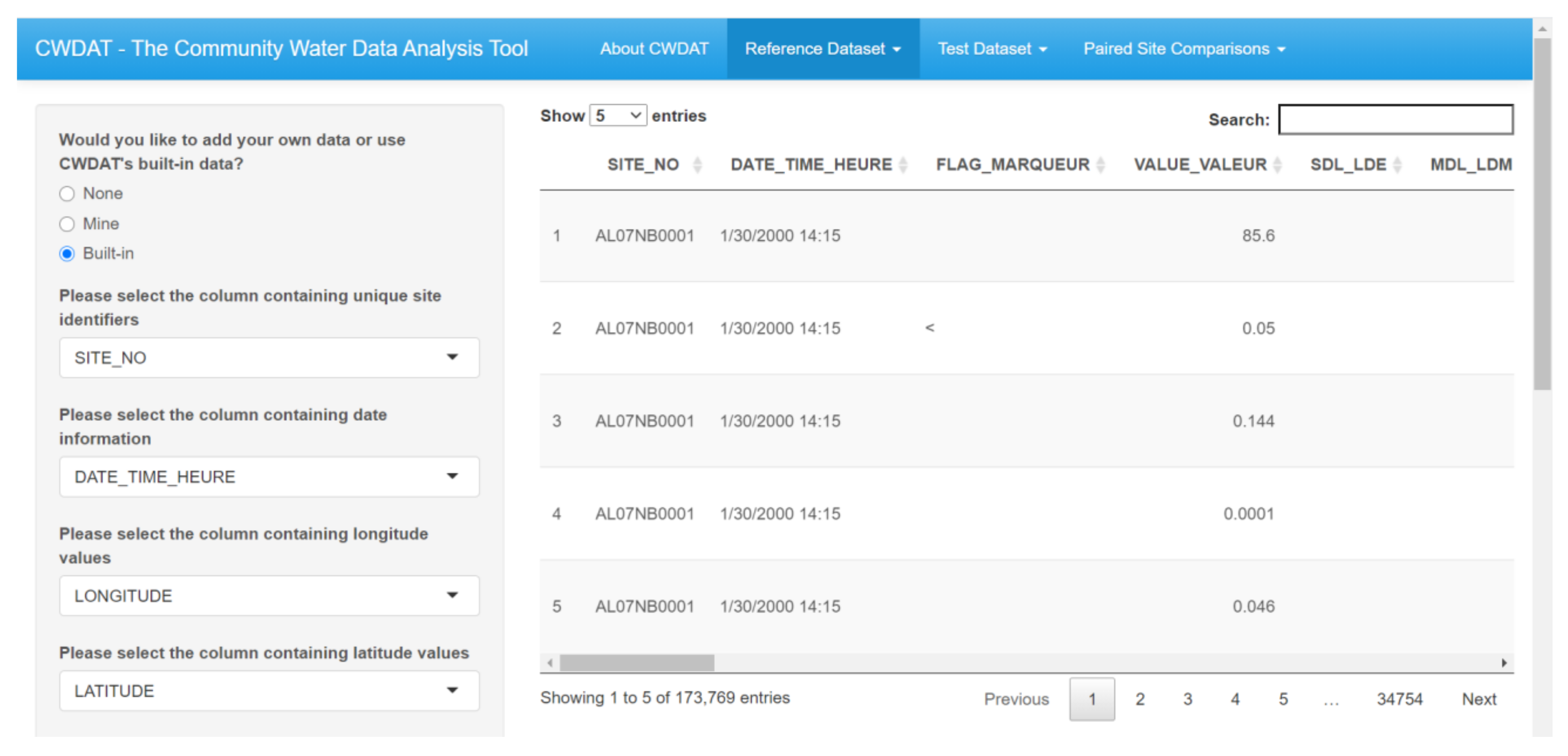
| Required Field | Description | Accepted Data Type(s) |
|---|---|---|
| Site identifier | A unique identifier for each discrete location water quality samples were collected or measurements were taken. This can be a name, code, number, or other categorical variable. Multiple observations from a single location should all share the same site identifier. | String, integer, float |
| Latitude | Latitude coordinate in decimal degrees using the WGS84 system. | Float |
| Longitude | Longitude coordinate in decimal degrees using the WGS84 system | Float |
| Date | Date of sample collection. Sample collection time may also be included in this column but is not required. | String, Date, POSIXlt (R) |
| Indicator/Variable(s) | Water quality indicators (e.g., temperature, pH, etc.). For “long” format data, indicator names will be listed in a single column. |
| Task | Purpose | CWDAT Section(s) | Informal Discussion Topics |
|---|---|---|---|
| 1 | Upload a .csv file of water quality data | Data Upload and Properties | File structures and sizes; metadata; sampling protocols and users’ experiences with data handling and storage |
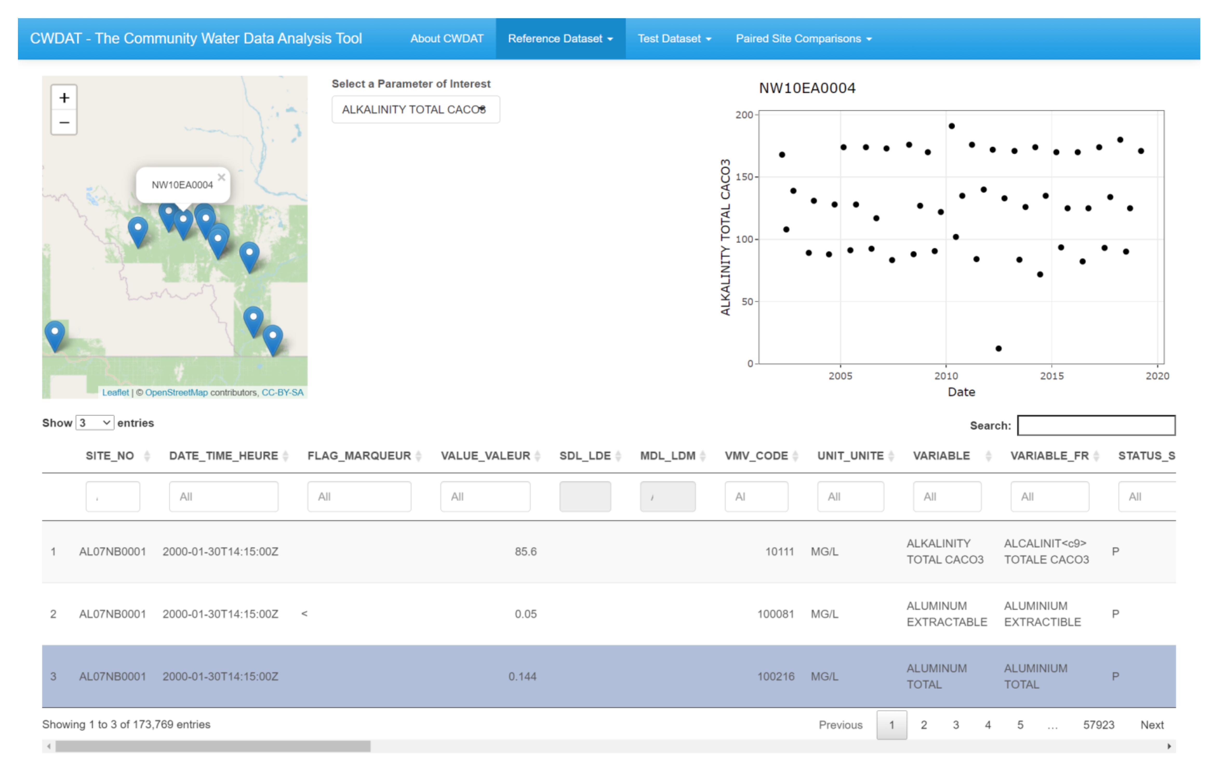
| 2 | Identify and explore outlier values | Spatial Visualization and Statistics | Data QAQC; users’ methods and needs; outlier detection |
| 3 | Visualize the data’s temporal scope | Temporal Coverage Summary | Sampling designs; CBWQM initiative organization and resources |
| 4 | Graph a subset of data | Graphic Visualization | Data presentation; viewer and stakeholder preferences and needs |
| data | data | ||
| 5 | Determine if a subset of test data is within the normal range of a reference baseline | Paired Site Comparisons | Data validation; QAQC; confidence in results; analysis outcomes |
| Role | Count | % |
| Scientist or researcher | 9 | 64 |
| NGO/Not-for-profit | 3 | 21 |
| Outreach | 3 | 21 |
| Data analyst | 2 | 14 |
| Volunteer | 2 | 14 |
| Government or leadership | 1 | 7 |
| Environmental consulting | 1 | 7 |
| Community member | 1 | 7 |
| Motivation | Count | % |
| Environmental awareness | 7 | 50 |
| Scientific research | 6 | 43 |
| Planning and decision-making | 4 | 29 |
| Metadata Standards | Data Interpretation | Communication/Sharing |
|---|---|---|
| Controlling for units | No consistent idea of how to use data | Privacy concerns |
| Inconsistent data labelling variations in instrumentation and laboratory procedures Variations in naming conventions Variations in file format anddata structures | Establishing trends and triggers | Internet capacity |
| Long-term analysis capacity | Communication media | |
| Perceived lack of quality | ||
| Lack of meaningful interpretation, coordination, and common reporting within and between community-based water quality monitoring/citizen scientist initiatives | File sizes |
Publisher’s Note: MDPI stays neutral with regard to jurisdictional claims in published maps and institutional affiliations. |
© 2021 by the authors. Licensee MDPI, Basel, Switzerland. This article is an open access article distributed under the terms and conditions of the Creative Commons Attribution (CC BY) license (https://creativecommons.org/licenses/by/4.0/).
Share and Cite
Gray, A.; Robertson, C.; Feick, R. CWDAT—An Open-Source Tool for the Visualization and Analysis of Community-Generated Water Quality Data. ISPRS Int. J. Geo-Inf. 2021, 10, 207. https://doi.org/10.3390/ijgi10040207
Gray A, Robertson C, Feick R. CWDAT—An Open-Source Tool for the Visualization and Analysis of Community-Generated Water Quality Data. ISPRS International Journal of Geo-Information. 2021; 10(4):207. https://doi.org/10.3390/ijgi10040207
Chicago/Turabian StyleGray, Annie, Colin Robertson, and Rob Feick. 2021. "CWDAT—An Open-Source Tool for the Visualization and Analysis of Community-Generated Water Quality Data" ISPRS International Journal of Geo-Information 10, no. 4: 207. https://doi.org/10.3390/ijgi10040207
APA StyleGray, A., Robertson, C., & Feick, R. (2021). CWDAT—An Open-Source Tool for the Visualization and Analysis of Community-Generated Water Quality Data. ISPRS International Journal of Geo-Information, 10(4), 207. https://doi.org/10.3390/ijgi10040207