
A GIS-Based Multi-Criterion Decision-Making Method to Select City Fire Brigade: A Case Study of Wuhan, China


Abstract
1. Introduction
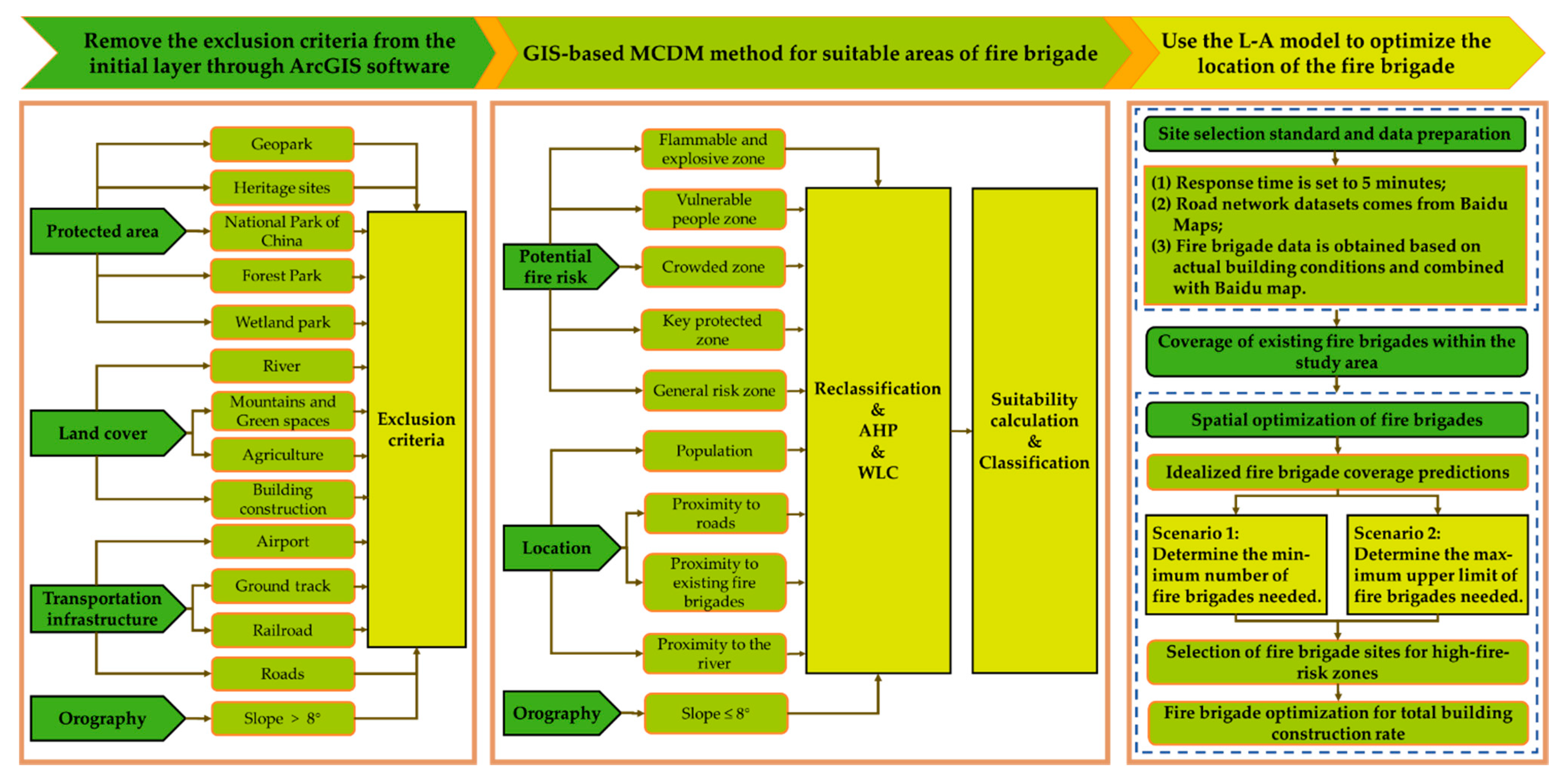
2. Materials and Methods
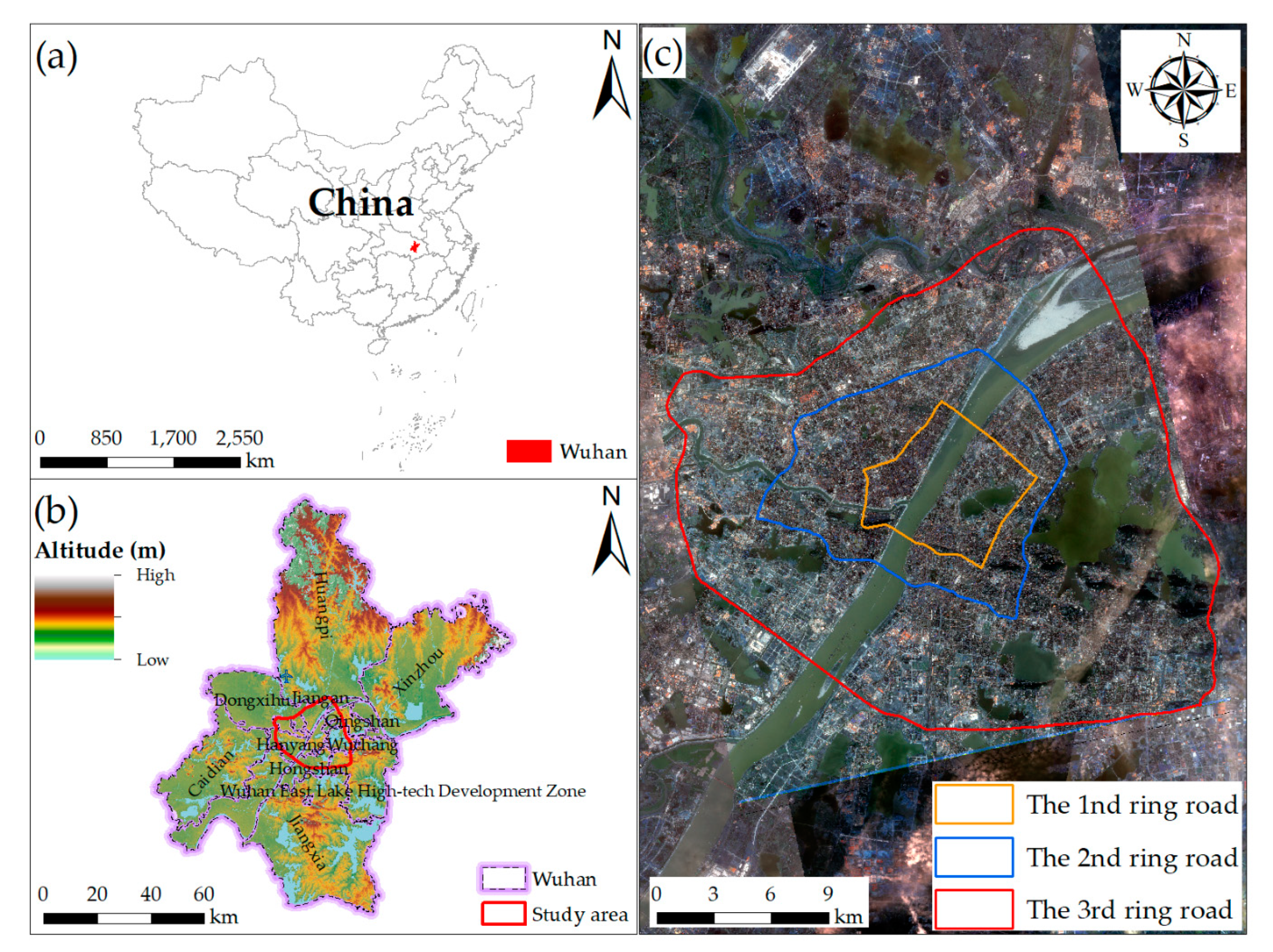
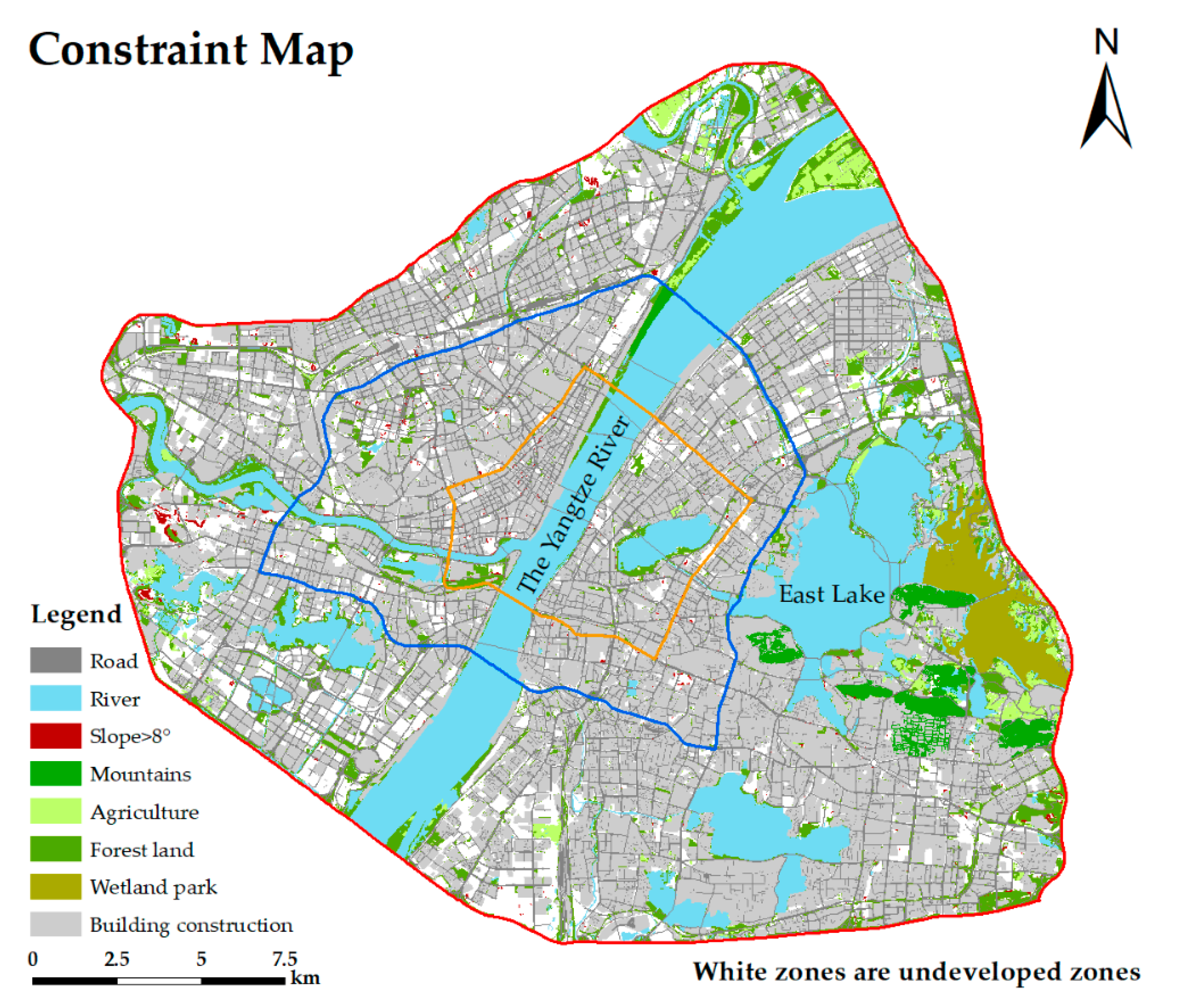
2.1. The Case Study
2.2. Methodology
2.2.1. Exclusion Criteria
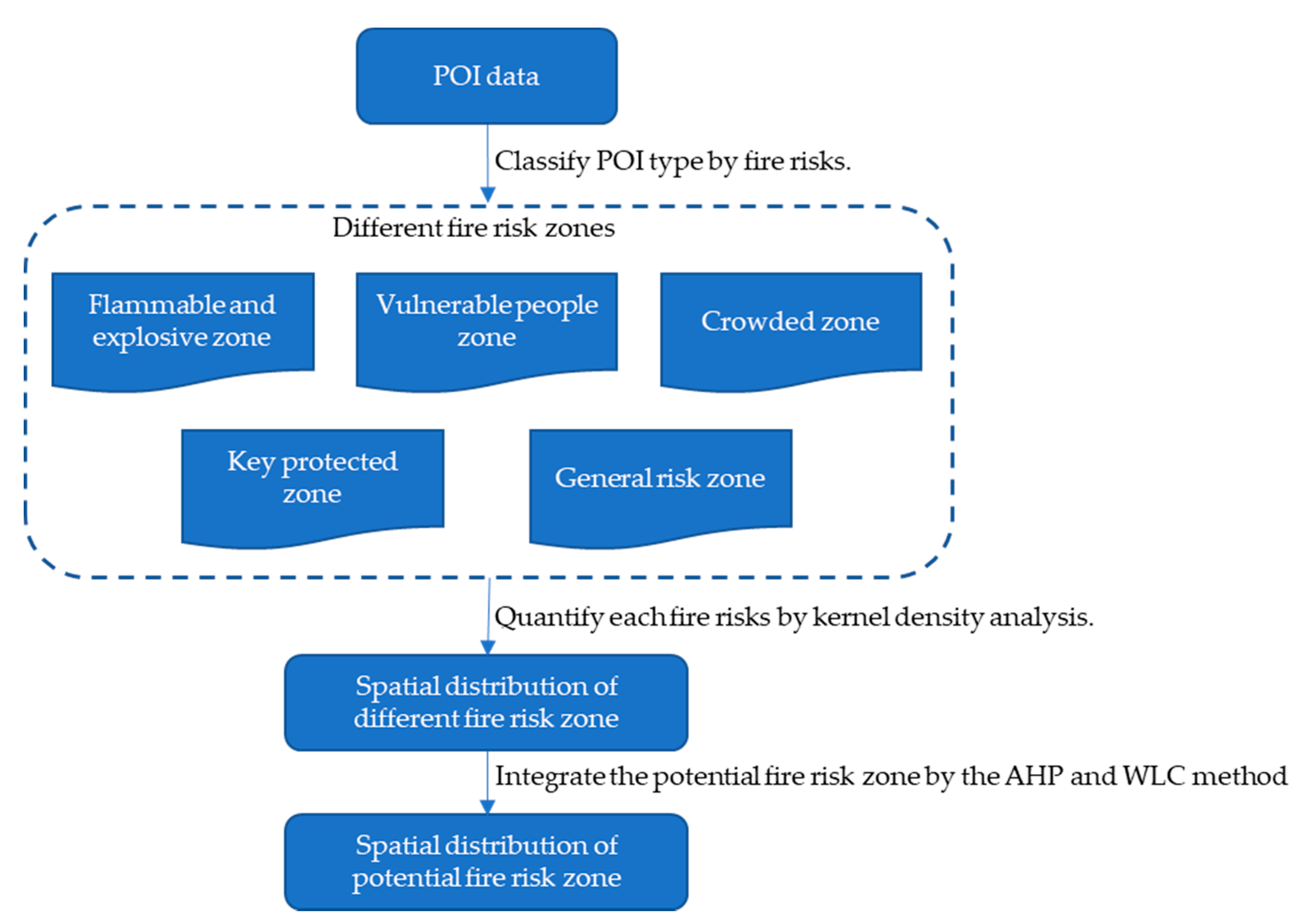
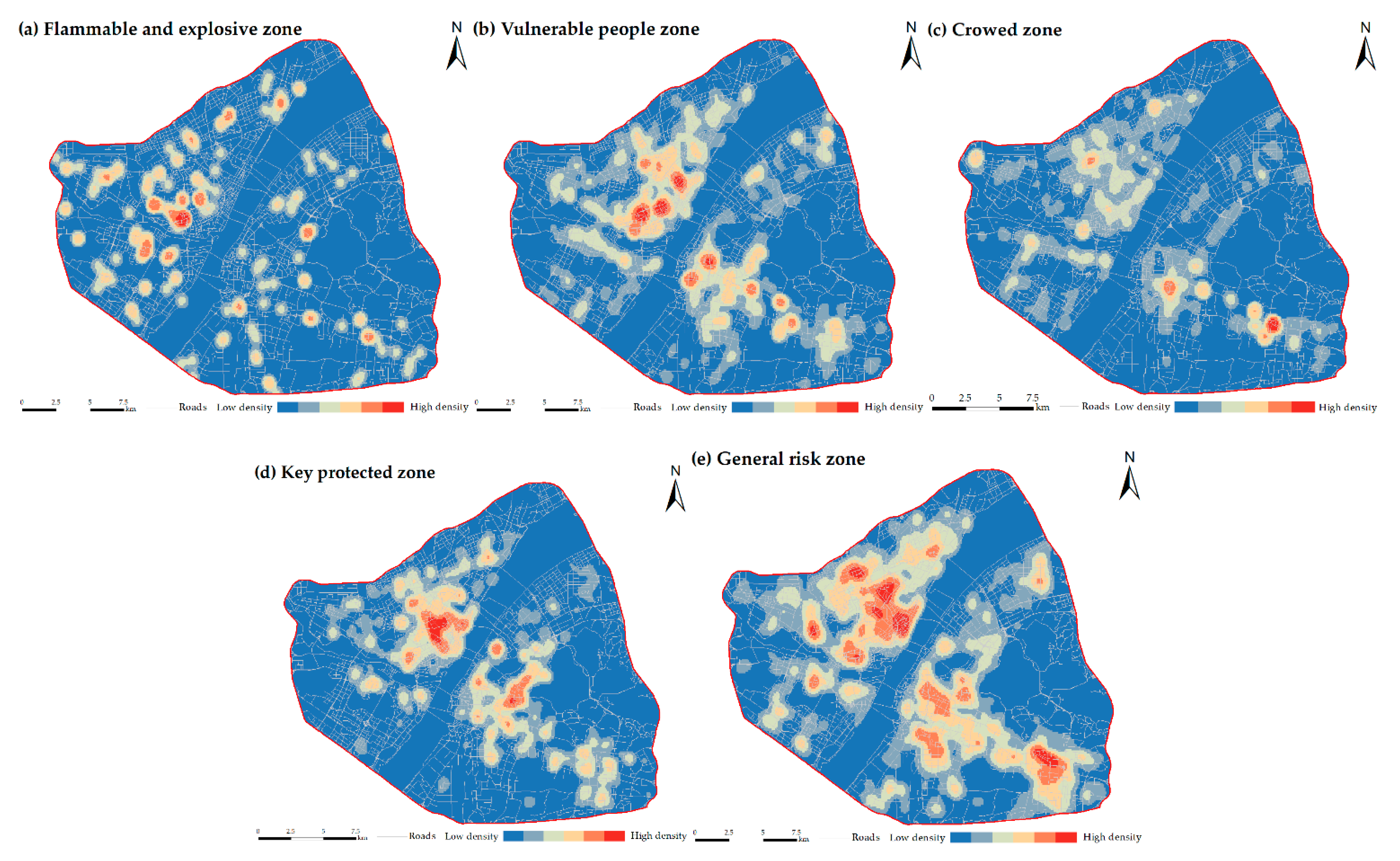
2.2.2. Fire-Risk Zone
- (1)
- Classifying point-of-interest type by fire risk
- (2)
- Integrate fire-risk zone through Analytic Hierarchy Process and weighted linear combination models.
- Analytic Hierarchy Process
- i.
- Calculate the maximum eigenvalue λmax of each comparison matrix.
- ii.
- Calculate the consistency index (CI) value by usingwhere λmax is the maximum eigenvalue of each comparison matrix, and n is the number of criteria or order matrix A.
- iii.
- Use Table 3 and the number n of standards used to obtain the random consistency index (RI) and then determine the CR by calculating the ratio of the CI to the RI:
- 2.
- Weighted linear combination
2.2.3. Evaluation Criteria
- (1)
- Fire-risk zone. A fire-risk zone reflects the degree of fire hazard in a certain area. When a fire occurs in a high-fire-risk zone, it may easily cause serious economic loss and casualties. Therefore, fire brigades must protect such zones so that, in the event of a sudden fire, firefighters can react optimally and save lives and property that would otherwise be lost in the fire.
- (2)
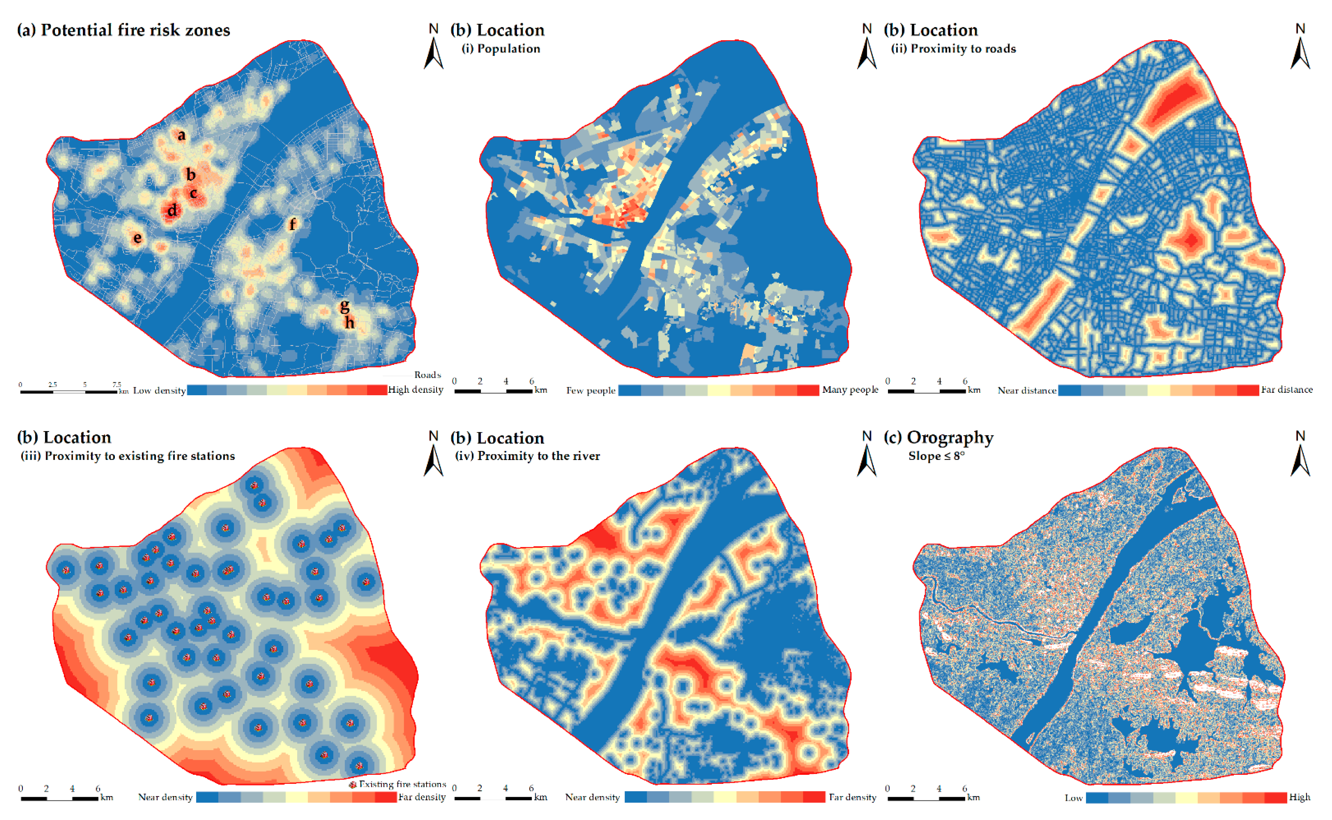
- Location. We now discuss spatial variables related to location. (i) Population. According to 2020 fire statistics, resident casualties account for 80.2% of the total casualties. Given the value of human life, the weighting for these data should be significant. Therefore, population is an important evaluation criterion for selecting sites for urban fire brigades. To optimize the rescue function of fire brigades, they should be built in densely populated areas. (ii) Proximity to roads. Being close to roads facilitates the entry and exit of fire trucks into fire zones, thereby reducing the reaction time for firefighting and rescue and the associated cost of firefighting. Therefore, the closer a fire brigade is to the road network, the better it is for fire rescue. (iii) Proximity to existing fire brigades. Gay and Siegel [57] and Johnston [58] argued that the criteria for evaluating fire brigades should include the distance between these brigades, which determines the location and number of fire brigades in a community. Therefore, the distance between existing fire brigades is retained as an evaluation criterion. (iv) Proximity to a river. Given that fire brigades must ensure adequate water supply for fire trucks, fluvial water resources can be vital for firefighting and for vehicle maintenance. Therefore, fire brigades should be positioned close to a river.
- (3)
- Orography. The terrain strongly affects the displacement of fire trucks and the concomitant time and costs for training and rescue. This is an important factor in choosing the location of fire brigades. The slope of the area near the fire brigade determines the acceptability of the site. Flat areas are more conducive to the construction of fire brigades than sloped areas.
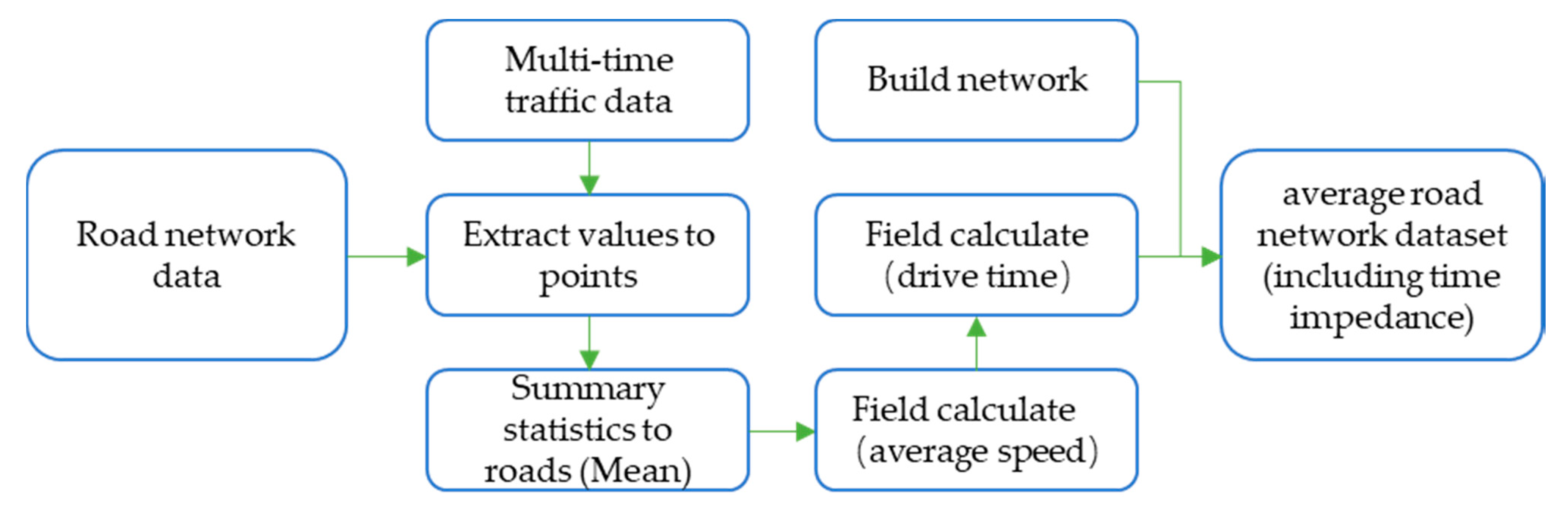
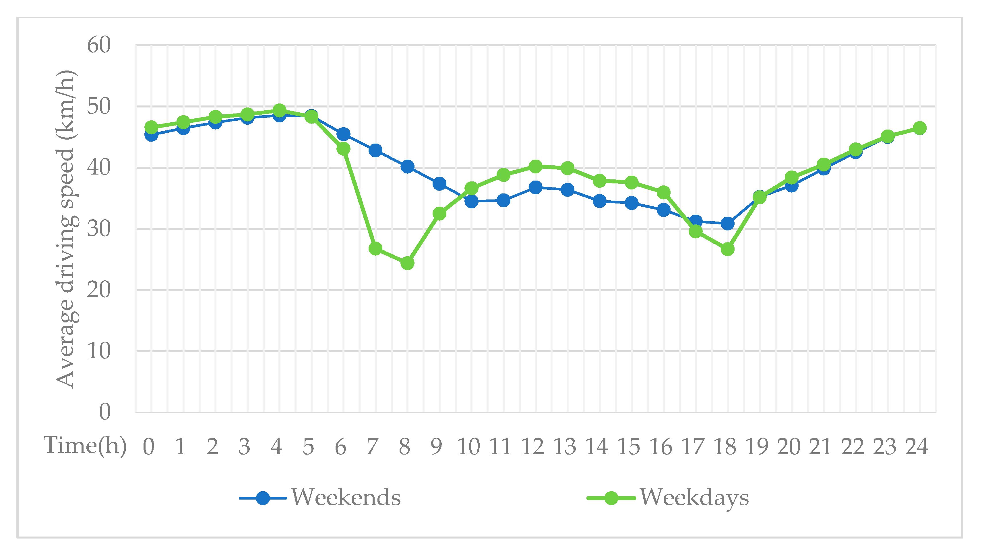
2.2.4. Average Road Network Datasets
2.2.5. Site Selection Standard and Model
- (1)
- Standard for rescue time and construction area of fire brigades. According to China’s “Code for the Planning of Urban Fire Control” (2015) and “Urban Fire Station Construction Standards” (2017), a fire brigade should be able to reach the edge of its jurisdiction within five minutes after receiving an alarm call. Thus, the coverage area of an ordinary fire brigade should not be greater than 7 km2. Special fire brigades with firefighting and rescue tasks have the same jurisdiction regulations as ordinary fire brigades.
- (2)
- Location allocation. The L-A model provides an effective method for selecting sites for public facilities [59,60,61,62] and has been successfully applied to the site selection of emergency facilities [62], such as the selection of a school site [60], a hospital site [61], and fire brigade site [19]. The scientific positioning of public service facilities can make supermarkets convenient for residents to shop, and supermarkets will also be profitable. Appropriate locations enable service facilities such as police stations and fire brigades to provide better services and make schools easier for students to access.
3. Results
3.1. Spatial Distribution of Exclusion Criteria
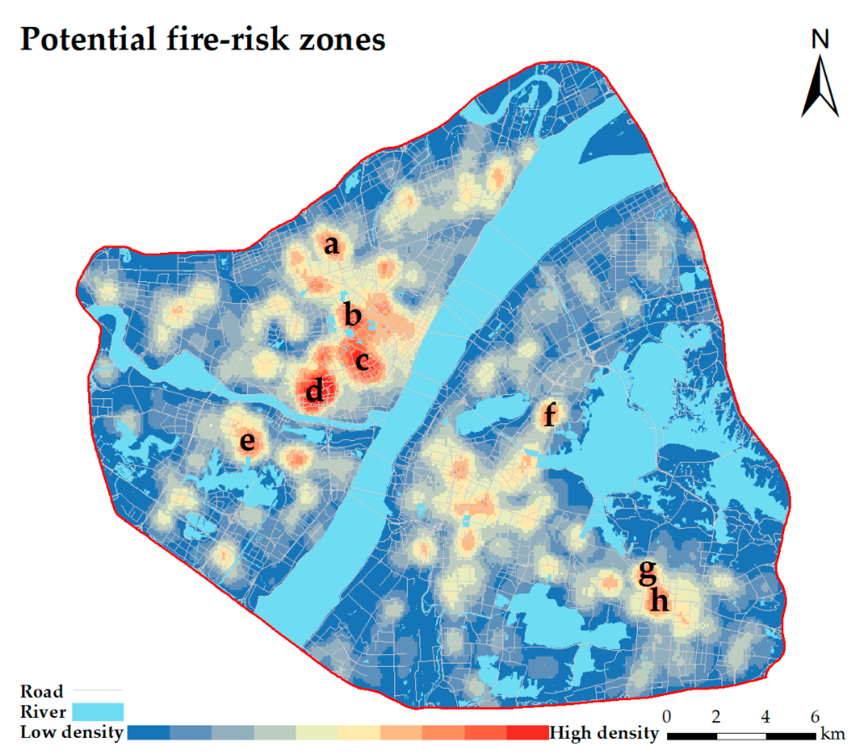
3.2. The Spatial Distribution of Fire-Risk Zones
3.3. Spatial Distribution of Evaluation Criteria
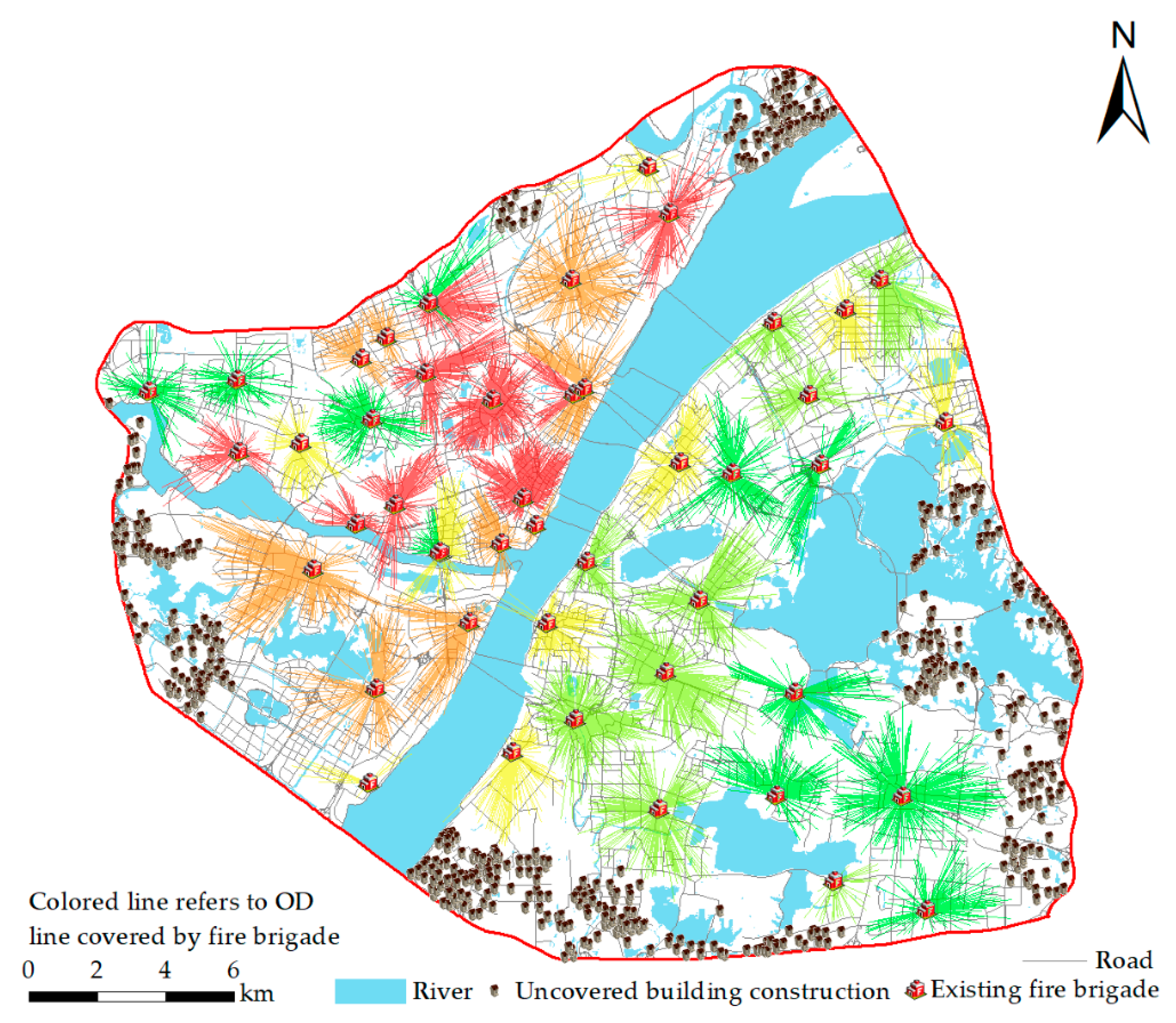
3.4. Coverage of Existing Fire Brigades
3.5. Spatial Optimization of Fire Brigades
- (1)
- Idealized fire brigade coverage predictions
- (2)
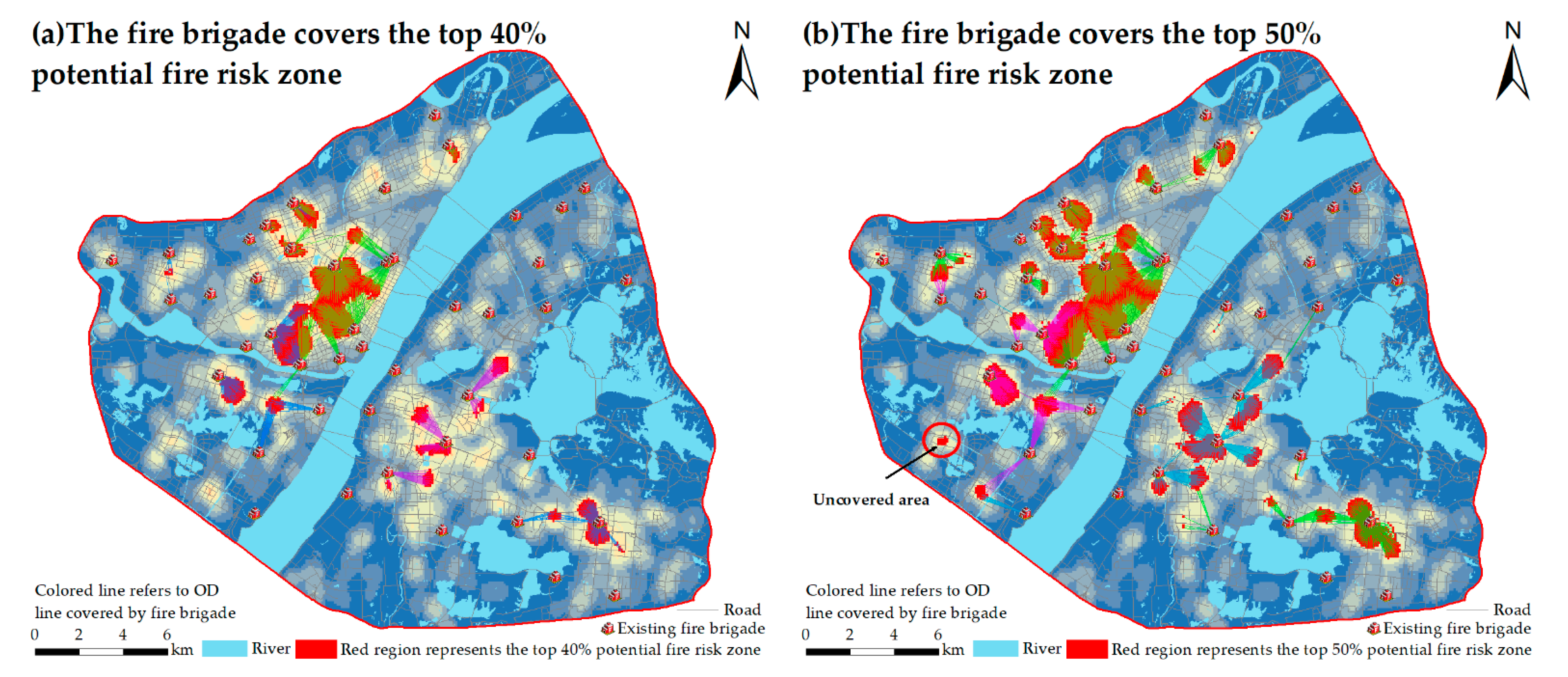
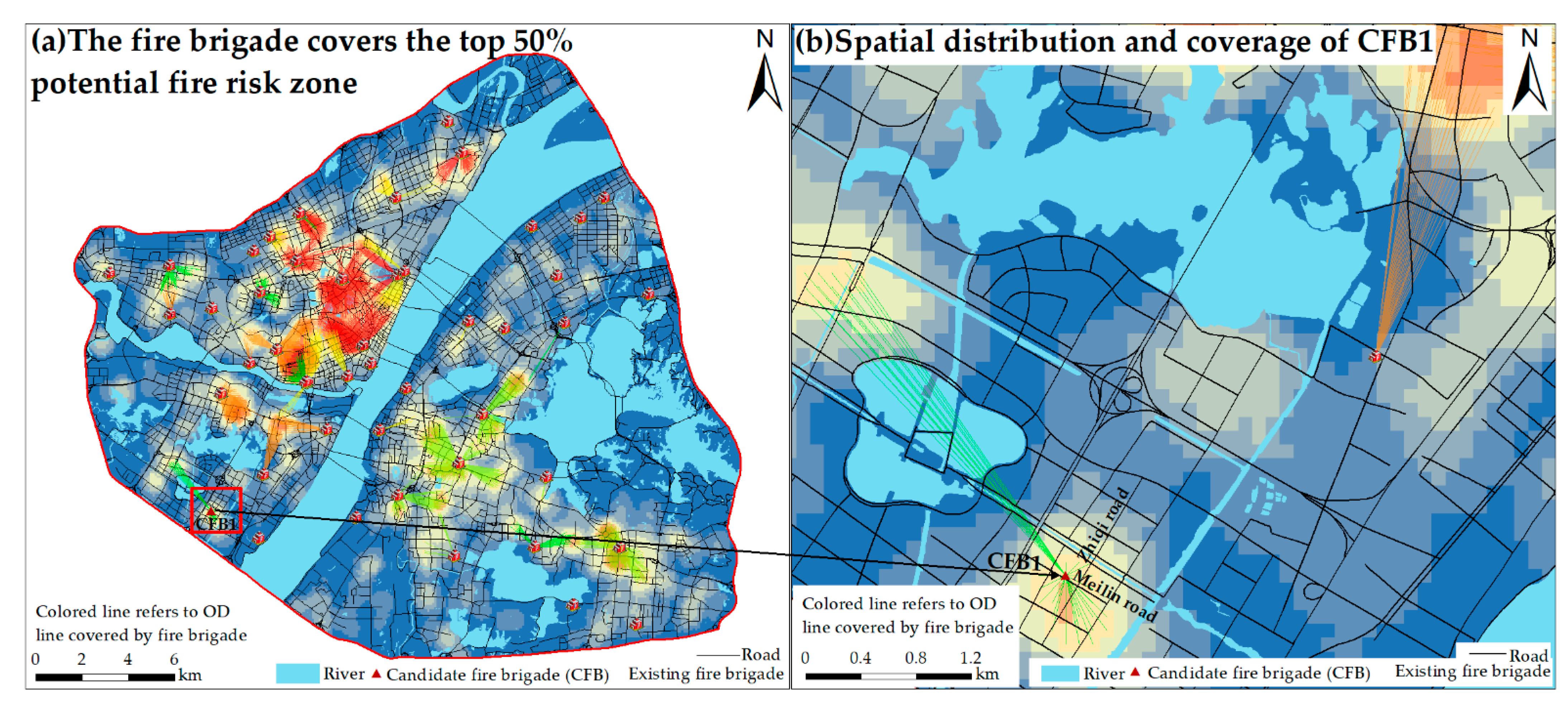
- Selection of fire brigade sites for high-fire-risk zones
- (3)
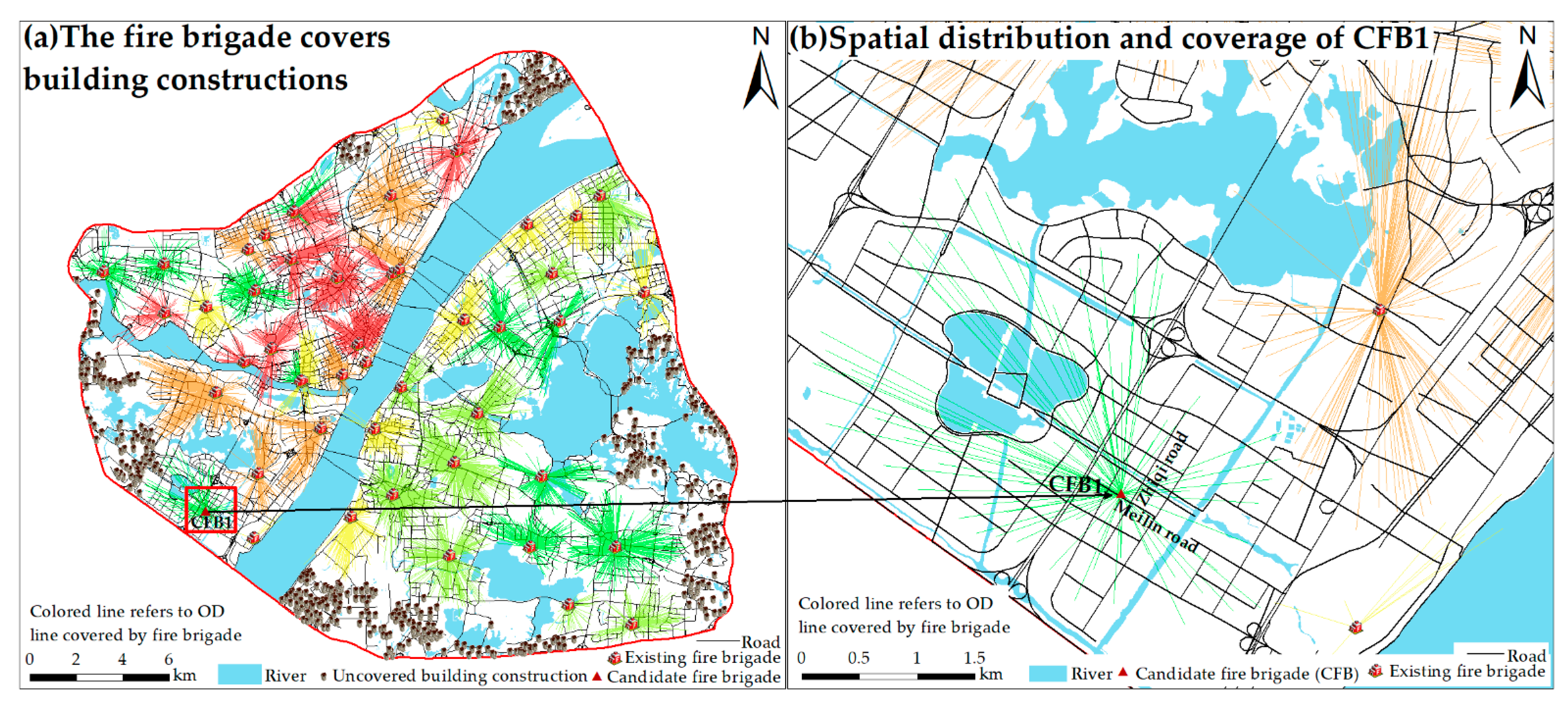
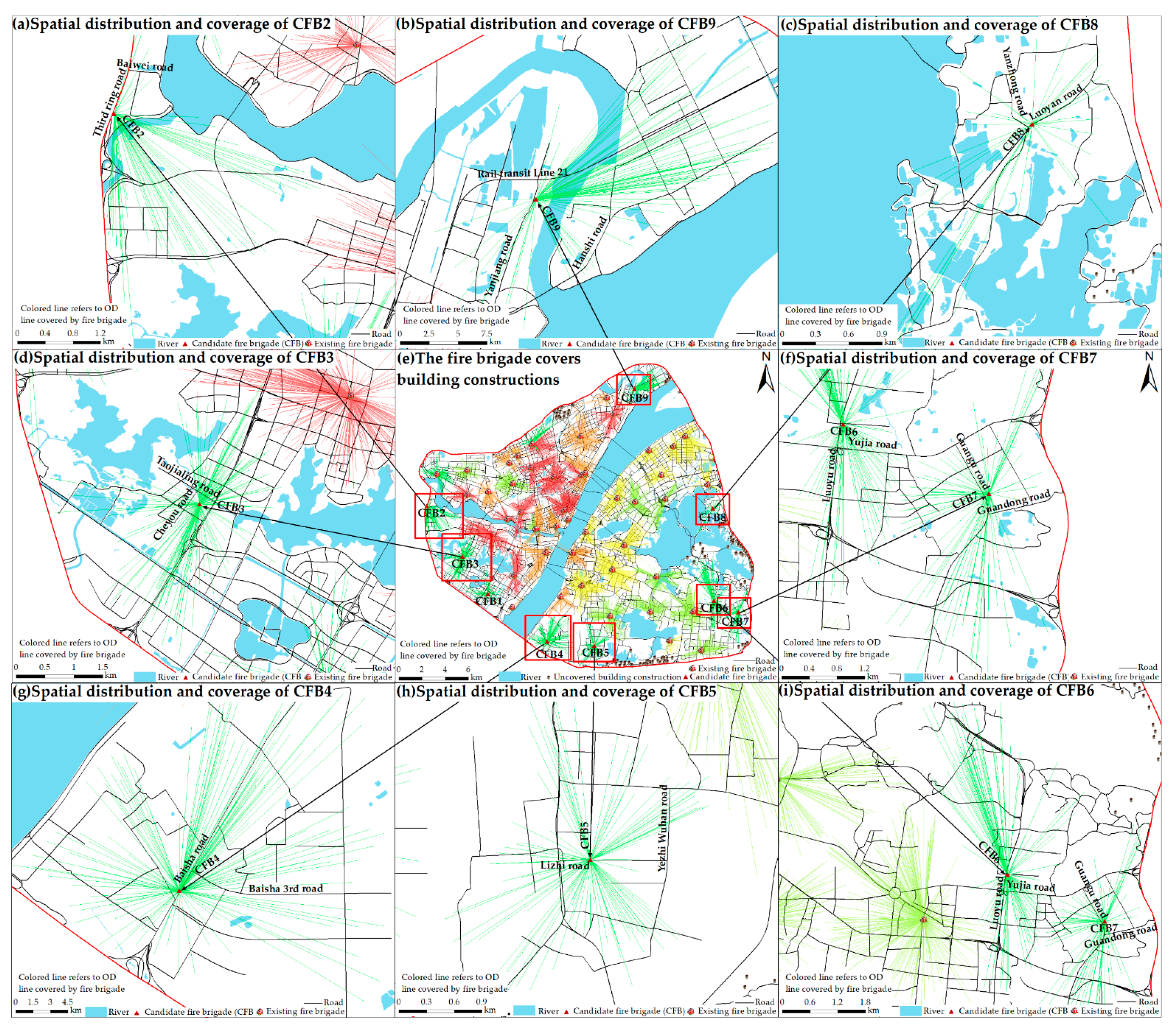
- Fire brigade optimization for total building construction rate
4. Discussion
5. Conclusions
- (1)
- An analysis reveals a good overall building coverage offered by the existing 47 fire brigades in the study area. These fire brigades cover 9310 buildings, for a coverage rate of 93.28%. An analysis of the coverage zones indicates a lack of fire brigade rescue services in the north, south, southwest, and east of the study area. An analysis of the coverage of fire-risk zones shows that the existing fire brigades cover 100% of the top 10% fire-risk areas, 100% of the top 30% fire-risk areas, and 98.3% of the top 50% fire-risk areas.
- (2)
- To attain the goal of improving the overall coverage of the top 50% high-fire-risk areas and buildings, we selected optimal fire brigade sites. Nine new fire brigades are proposed, which would increase the overall coverage to 99.01% for buildings and 99.08% for the top 50% high-fire-risk areas, thereby ensuring that most demand points are covered.
Author Contributions
Funding
Institutional Review Board Statement
Informed Consent Statement
Data Availability Statement
Acknowledgments
Conflicts of Interest
References
- Dong, X.M.; Li, Y.; Pan, Y.L.; Huang, Y.J.; Cheng, X.D. Study on urban fire station planning based on fire risk assessment and GIS technology. Procedia Eng. 2018, 211, 124–130. [Google Scholar] [CrossRef]
- Xu, D.S.; Zeng, J.X. Evaluation of China’s urbanization quality and analysis of its spatial pattern transformation based on the modern life index. Acta Geogr. Sin. 2016, 71, 194–204. [Google Scholar]
- Wang, W.; Xu, Z.; Sun, D.; Lan, T. Spatial optimization of mega-city fire stations based on multi-source geospatial data: A case study in Beijing. ISPRS Int. J. Geo-Inf. 2021, 10, 282. [Google Scholar] [CrossRef]
- China Fire Yearbook Editorial Board. 2020. Available online: http://www.china-fire.com/ (accessed on 6 October 2021).
- Ceyhan, E.; Kıvanç, E.; Şebnem, D. Exploratory and inferential methods for spatio-temporal analysis of residential fire clustering in urban areas. Fire Saf. J. 2013, 58, 226–239. [Google Scholar] [CrossRef]
- Kiran, K.C.; Jonathan, C. Modelling residential fire incident response times: A spatial analytic approach. Appl. Geogr. 2017, 84, 64–74. [Google Scholar] [CrossRef]
- Xia, Z.; Li, H.; Chen, Y. An integrated spatial clustering analysis method for identifying urban fire risk locations in a network-constrained environment: A case study in nanjing, china. ISPRS Int. J. Geo-Inf. 2017, 6, 370. [Google Scholar] [CrossRef]
- Zhou, L.; Dang, X.; Sun, Q.; Wang, S. Multi-scenario simulation of urban land change in Shanghai by random forest and CA-Markov model. Sustain. Cities Soc. 2020, 55, 102045. [Google Scholar] [CrossRef]
- Wuschke, K.; Clare, J.; Garis, L. Temporal and geographic clustering of residential structure fires: A theoretical platform for targeted fire prevention. Fire Saf. J. 2013, 62, 3–12. [Google Scholar] [CrossRef]
- Hong, C. Study on optimization of the spatial distribution of city fire station in Lu’an city. Fire Sci. Technol. 2009, 5, 321–326. [Google Scholar]
- Hogg, J. The siting of fire stations. J. Oper. Res. Soc. 1968, 19, 275–287. [Google Scholar] [CrossRef]
- Helly, W. Urban Systems Models; Academic Press: Cambridge, MA, USA, 1975. [Google Scholar] [CrossRef]
- Plane, D.R.; Thomas, E.; Hendrick, T.E. Mathematical programming and the location of fire companies for the Denver fire department. Oper. Res. 1977, 25, 563–578. [Google Scholar] [CrossRef]
- Reilly, J.M.; Mirchandani, P.B. Development and application of a fire station placement model. Fire Technol. 1985, 21, 181–198. [Google Scholar] [CrossRef]
- Habibi, K.; Lotfi, S.; Koohsari, M.J. Spatial analysis of urban fire station locations by integrating AHP model and IO logic using GIS (a case study of zone 6 of Tehran). J. Appl. Sci. 2008, 8, 3302–3315. [Google Scholar] [CrossRef]
- Erden, T.; Coşkun, M.Z. Multi-criteria site selection for fire services: The interaction with analytic hierarchy process and geographic information systems. Nat. Hazards Earth Syst. Sci. 2010, 10, 2127–2134. [Google Scholar] [CrossRef]
- Chaudhary, P.; Chhetri, S.K.; Joshi, K.M.; Shrestha, B.M.; Kayastha, P. Application of an Analytic Hierarchy Process (AHP) in the GIS interface for suitable fire site selection: A case study from Kathmandu Metropolitan city, Nepal. Socio-Econ. Plan. Sci. 2016, 53, 60–71. [Google Scholar] [CrossRef]
- Chen, C.; Ren, A. Optimization of fire station locations using computer. Qinghua Daxue Xuebao/J. Tsinghua Univ. (China) 2003, 43, 1390–1393. [Google Scholar]
- Murray, A.T. Optimising the spatial location of urban fire stations. Fire Saf. J. 2013, 62, 64–71. [Google Scholar] [CrossRef]
- Owen, S.H.; Daskin, M.S. Strategic facility location: A review. Eur. J. Oper. Res. 1998, 111, 423–447. [Google Scholar] [CrossRef]
- Badri, M.A.; Mortagy, A.K.; Alsayed, C.A. A multi-objective model for locating fire stations. Eur. J. Oper. Res. 1998, 110, 243–260. [Google Scholar] [CrossRef]
- Chevalier, P.; Thomas, I.; Geraets, D.; Goetghebeur, E.; Janssens, O.; Peeters, D.; Plastria, F. Locating fire stations: An integrated approach for Belgium. Socio-Econ. Plan. Sci. 2012, 46, 173–182. [Google Scholar] [CrossRef]
- Barr, R.C.; Caputo, A.P. Planning fire station locations. In Fire Protection Handbook; Cote, A.E., Ed.; National Fire Protection Association: Quincy, MA, USA, 1996; pp. 311–318. [Google Scholar]
- Yang, L.; Jones, B.F.; Yang, S.H. A fuzzy multi-objective programming for optimization of fire station locations through genetic algorithms. Eur. J. Oper. Res. 2007, 181, 903–915. [Google Scholar] [CrossRef]
- Schreuder, J.A.M. Application of a location model to fire stations in Rotterdam. Eur. J. Oper. Res. 1981, 6, 212–219. [Google Scholar] [CrossRef]
- Kanoun, I.; Chabchoub, H.; Aouni, B. Goal programming model for fire and emergency service facilities site selection. INFOR: Inf. Syst. Oper. Res. 2010, 48, 143–153. [Google Scholar] [CrossRef][Green Version]
- Liu, N.; Huang, B.; Chandramouli, M. Optimal siting of fire stations using GIS and ANT algorithm. J. Comput. Civ. Eng. 2006, 20, 361–369. [Google Scholar] [CrossRef]
- Uno, T.; Kato, K.; Katagiri, H. An application of interactive fuzzy satisficing approach with particle swarm optimization for multi-objective emergency facility location problem with a-distance. In 2007 IEEE Symposium on Computational Intelligence in Multi-Criteria Decision-Making; IEEE: Kagamiyama, Japan, 2007. [Google Scholar] [CrossRef]
- Li, X.; Xu, G.; Chen, E.; Zong, Y. Learning recency based comparative choice towards point-of-interest recommendation. Expert Syst. Appl. 2015, 42, 4274–4283. [Google Scholar] [CrossRef]
- Yao, Y.; Li, X.; Liu, X.; Liu, P.; Liang, Z.; Zhang, J.; Mai, K. Sensing spatial distribution of urban land use by integrating points-of-interest and Google Word2Vec model. Int. J. Geogr. Inf. Sci. 2017, 31, 825–848. [Google Scholar] [CrossRef]
- Milias, V.; Psyllidis, A. Assessing the influence of point-of-interest features on the classification of place categories. Comput. Environ. Urban Syst. 2021, 86, 101597. [Google Scholar] [CrossRef]
- Martí, P.; Serrano-Estrada, L.; Nolasco-Cirugeda, A. Social media data: Challenges, opportunities and limitations in urban studies. Comput. Environ. Urban Syst. 2019, 74, 161–174. [Google Scholar] [CrossRef]
- Xiong, X.; Qiao, S.; Li, Y.; Han, N.; Yuan, G.; Zhang, Y. A point-of-interest suggestion algorithm in Multi-source geo-social networks. Eng. Appl. Artif. Intell. 2020, 88, 103374. [Google Scholar] [CrossRef]
- Zhu, D.; Wang, N.; Wu, L.; Liu, Y. Street as a big geo-data assembly and analysis unit in urban studies: A case study using Beijing taxi data. Appl. Geogr. 2017, 86, 152–164. [Google Scholar] [CrossRef]
- McKenzie, G.; Janowicz, K. Where is also about time: A location-distortion model to improve reverse geocoding using behavior driven temporal semantic signatures. Comput. Environ. Urban Syst. 2015, 54, 1–13. [Google Scholar] [CrossRef]
- Wuhan Municipal Statistics Bureau; State Statistical Bureau Wuhan Investigation Team. Wuhan Statistical Yearbook 2020; China Statistics Press: Wuhan, China, 2020; Volume 32, p. 9. Available online: http://tjj.hubei.gov.cn/tjsj/sjkscx/tjnj/gsztj/whs/202102/P020210202610060079335.pdf (accessed on 10 October 2021).
- Aly, A.; Jensen, S.S.; Pedersen, A.B. 2017. Solar power potential of Tanzania: Identifying CSP and PV hot spots through a GIS multicriteria decision making analysis. Renew. Energ. 2017, 113, 159–175. [Google Scholar] [CrossRef]
- Zhan, Q.M.; Yang, S. Optimization of emergency facilities layout in villages. J. Geo-Inf. Sci. 2019, 21, 641–653. [Google Scholar] [CrossRef]
- Kim, M.O.; Kim, K.; Yun, J.H.; Kim, M.K. Fire risk assessment of cable bridges for installation of firefighting facilities. Fire Saf. J. 2020, 115, 103146. [Google Scholar] [CrossRef]
- Chainey, S.P. Examining the influence of cell size and bandwidth size on kernel density estimation crime hotspot maps for predicting spatial patterns of crime. Bull. Geogr. Soc. Liege 2013, 60, 7–19. [Google Scholar]
- Lin, Y.P.; Chu, H.J.; Wu, C.F.; Chang, T.K.; Chen, C.Y. Hotspot analysis of spatial environmental pollutants using kernel density estimation and geostatistical techniques. Int. J. Environ. Res. Public Health 2011, 8, 75–88. [Google Scholar] [CrossRef]
- Silverman, B.W. Density Estimation for Statistics and Data Anal, 1st ed.; Routledge: Bath, UK, 1998. [Google Scholar] [CrossRef]
- Potić, I.; Golić, R.; Joksimović, T. Analysis of insolation potential of Knjaževac Municipality (Serbia) using multi-criteria approach. Renew. Sustain. Energy Rev. 2016, 56, 235–245. [Google Scholar] [CrossRef]
- de FSM Russo, R.; Camanho, R. Criteria in AHP: A systematic review of literature. Procedia Comput. Sci. 2015, 55, 1123–1132. [Google Scholar] [CrossRef]
- Dožić, S.; Kalić, M. Comparison of two MCDM methodologies in aircraft type selection problem. Transp. Res. Procedia 2015, 10, 910–919. [Google Scholar] [CrossRef]
- Saaty, T.L. An Eigenvalue Allocation Model for Prioritization and Planning; Energy Management and Policy Center, University of pennsylvania: Philadelphia, PA, USA, 1972; pp. 28–31. [Google Scholar]
- Höfer, T.; Sunak, Y.; Siddique, H.; Madlener, R. Wind farm siting using a spatial Analytic Hierarchy Process approach: A case study of the Städteregion Aachen. Appl. Energy 2016, 163, 222–243. [Google Scholar] [CrossRef]
- Rinner, C.; Voss, S. MCDA4ArcMap–an open-source multi-criteria decision analysis and geovisualization tool for ArcGIS 10. Feature Artic. Cart. Newsl. Can. Cartogr. Assoc. 2013, 86, 12–13. [Google Scholar]
- Pinar, A.O.; Yasin, E.M.; Ertugrul, C.; Cam, E.; Inanc, N. Optimal site selection for a solar power plant in the central anatolian region of Turkey. Int. J. Photoenergy 2017, 2017, 1–13. [Google Scholar] [CrossRef]
- Chakraborty, S.; Banik, D. Design of a material handling equipment selection model using analytic hierarchy process. Int. J. Adv. Manuf. Technol. 2006, 28, 1237–1245. [Google Scholar] [CrossRef]
- Umagandhi, R.; Kumar, A.S. Search query recommendations in web information retrieval using query logs. In Web Usage Mining Techniques and Applications across Industries; IGI Global: Coimbatore, India, 2017; pp. 199–222. [Google Scholar] [CrossRef]
- Pardeshi, S.D.; Autade, S.E.; Pardeshi, S.S. Landslide hazard assessment: Recent trends and techniques. SpringerPlus 2013, 2, 1–11. [Google Scholar] [CrossRef]
- Nagarajan, R.; Roy, A.; Kumar, R.V.; Mukherjee, A.; Khire, M.V. Landslide hazard susceptibility mapping based on terrain and climatic factors for tropical monsoon regions. Bull. Eng. Geol. Environ. 2000, 58, 275–287. [Google Scholar] [CrossRef]
- Doorga, J.R.; Rughooputh, S.D.; Boojhawon, R. Multi-criteria GIS-based modelling technique for identifying potential solar farm sites: A case study in Mauritius. Renew. Energy 2019, 133, 1201–1219. [Google Scholar] [CrossRef]
- Coburn, T.C. GIS and multicriteria decision analysis. Comput. Geosci. 2000, 9, 1067–1068. [Google Scholar] [CrossRef]
- Sun, L.; Jiang, Y.; Guo, Q.; Ji, L.; Xie, Y.; Qiao, Q.; Xiao, K. A GIS-based multi-criteria decision making method for the potential assessment and suitable sites selection of PV and CSP plants. Resour. Conserv. Recycl. 2021, 168, 105306. [Google Scholar] [CrossRef]
- Gay, W.; Siegel, A. Fire station location analysis: A comprehensive planning approach. ICMA MIS Rep. 1987, 19, 1–17. [Google Scholar]
- Johnston, J. The cost effectiveness of fire station siting and the impact on emergency response. Natl. Fire Acad. 1999, 1, 1. [Google Scholar]
- Cooper, L. Location-allocation problems. Oper. Res. 1963, 11, 331–343. [Google Scholar] [CrossRef]
- Menezes, R.C.; Pizzolato, N.D. Locating public schools in fast expanding areas: Application of the capacitated p-median and maximal covering location models. Pesqui. Oper. 2014, 34, 301–317. [Google Scholar] [CrossRef]
- Zarrinpoor, N.; Fallahnezhad, M.S.; Pishvaee, M.S. Design of a reliable hierarchical location-allocation model under disruptions for health service networks: A two-stage robust approach. Comput. Ind. Eng. 2017, 109, 130–150. [Google Scholar] [CrossRef]
- Rahman, M.; Chen, N.; Islam, M.M.; Dewan, A.; Pourghasemi, H.R.; Washakh RM, A.; Ahmed, N. Location-allocation modeling for emergency evacuation planning with GIS and remote sensing: A case study of Northeast Bangladesh. Geosci. Front. 2021, 12, 101095. [Google Scholar] [CrossRef]


| Fire-Risk Zone | POI Data Category |
|---|---|
| Flammable and explosive zone | Chemical plants, gas stations, manufacturing enterprises, etc. |
| Vulnerable-people zone | Kindergartens, elementary schools, junior high schools, emergency centers, hospitals, etc. |
| Crowded zone | Shopping centers, train stations, subway stations, bus stations, etc. |
| Key protected zone | Government agencies, social organizations, museums, scenic spots, etc. |
| General risk zone | Business housing, corporate and lifestyle services, etc. |
| Numerical Scale | Definition (i with Respect to j) | Value | |
|---|---|---|---|
| aij | aji | ||
| 1 | Equal importance | 1 | 1 |
| 3 | Moderate importance | 3 | 1/3 |
| 5 | Strong importance | 5 | 1/5 |
| 7 | Very strong importance | 7 | 1/7 |
| 9 | Extreme importance | 9 | 1/9 |
| 2, 4, 6, 8 | Intermediate values | 2, 4, 6, 8 | 1/2, 1/4, 1/6, 1/8 |
| n | 1 | 2 | 3 | 4 | 5 | 6 | 7 | 8 | 9 | 10 |
|---|---|---|---|---|---|---|---|---|---|---|
| RI | 0 | 0 | 0.58 | 0.90 | 1.12 | 1.24 | 1.32 | 1.41 | 1.45 | 1.49 |
| Maximize Coverage Location Problem (MCLP) | Minimize Facilities Coverage Problem (LSCP) | |
|---|---|---|
| Objective function | Maximize | Minimize |
| Subject to |
| Exclusion Criterion | Constraint Variable | Restrictive Area | |
|---|---|---|---|
| EC1 | Protected area | Wetland park | 10.20 km2 |
| EC2 | Land cover | River | 125.74 km2 |
| Agriculture | 8.86 km2 | ||
| Mountains | 117.61 m2 | ||
| Forest land | 42.72 km2 | ||
| Building construction | 176.36 km2 | ||
| EC3 | Transport infrastructure | Road (including railway) | 61.53 km2 |
| EC4 | Slope | >8° | 23.48 km2 |
| Z1 | Z2 | Z3 | Z4 | Z5 | Weights | CR (%) | |
|---|---|---|---|---|---|---|---|
| Z1 | 1 | 2 | 2 | 2 | 2 | 32.3% | 4.3 |
| Z2 | 1/2 | 1 | 1 | 1 | 2 | 24.5% | |
| Z3 | 1/2 | 1 | 1 | 1 | 2 | 18.5% | |
| Z4 | 1/2 | 1 | 1 | 1 | 2 | 14.1% | |
| Z5 | 1/2 | 1/2 | 1/2 | 1/2 | 1 | 10.7% |
| Score | Evaluation Criteria | ||||
|---|---|---|---|---|---|
| Flammable and Explosive Zone | Vulnerable People Zone | Crowded Zone | Key Protected Zone | General Risk Zone | |
| 9 | >84,966.50 | >860,656.25 | >1,648,156.50 | >577,049.50 | >20,545,847.33 |
| 8 | 48,545.16–84,966.50 | 596,949.00–860,656.25 | 962,945.25–1648,156.50 | 400,483.00–577,049.50 | 15,293,334.50–20,545,847.33 |
| 7 | 33,427.66–48,545.16 | 406,699.50–596,949.00 | 578,310.16–962,945.25 | 286,380.50–400,483.00 | 11,730,192.83–15,293,334.50 |
| 6 | 23,864.00–33,427.66 | 277,284.00–406,699.50 | 355,903.00–578,310.16 | 204,857.83–286,380.50 | 8,857,090.00–11,730,192.83 |
| 5 | 16,737.50–23,864.00 | 184,978.00–277,284.00 | 214,923.75–355,903.00 | 144,612.00–204,857.83 | 6,454,159.00–8,857,090.00 |
| 4 | 11,100.50–16,737.50 | 114,927.25–184,978.00 | 127,995.00–214,923.75 | 94,521.00–144,612.00 | 4,377,895.75–6,454,159.00 |
| 3 | 6384.75–11,100.50 | 63,171.50–114,927.25 | 67,135.00–127,995.00 | 51,279.16–94,521.00 | 2,536,605.50–4,377,895.75 |
| 2 | 2088.50–6384.75 | 22,307.00–63,171.50 | 24,054.25–67,135.00 | 17,038.00–51,279.16 | 943,294.00–2,536,605.50 |
| 1 | ≤2088.50 | ≤22,307.00 | ≤24,054.25 | ≤17,038.00 | ≤943,294.00 |
| Type of Fire-Risk Zone | Fire-Risk Area Category (9 Levels) | Area (km2) | Proportion (%) |
|---|---|---|---|
| Fire-risk zone | 1 | 227.48 | 43.38 |
| 2 | 110.91 | 21.15 | |
| 3 | 79.98 | 15.25 | |
| 4 | 44.02 | 8.39 | |
| 5 | 29.34 | 5.60 | |
| 6 | 17.71 | 3.38 | |
| 7 | 9.86 | 1.88 | |
| 8 | 3.79 | 0.72 | |
| 9 | 1.30 | 0.25 |
| Factor | Fire-Risk Zone | Location | Orography | ||||
|---|---|---|---|---|---|---|---|
| Evaluation Criterion | Potential Fire-Risk Zones | Population | Proximity to Roads | Proximity to Existing Fire Brigade | Proximity to the River | Slope ≤ 8° | Evaluation Criterion |
| Score | 9 | >6.37 | >133,563 | ≤58.64 | ≤705.91 | ≤75.26 | ≤1.26 |
| 8 | 5.46–6.37 | 91,067–133,563 | 58.64–130.64 | 705.91–1163.75 | 75.26–208.77 | 1.26–2.25 | |
| 7 | 4.73–5.46 | 67,120–91,067 | 130.64–223.76 | 1163.75–1611.16 | 208.77–352.69 | 2.25–3.02 | |
| 6 | 4.09–4.73 | 49,356–67,120 | 223.76–346.78 | 1611.16–2110.72 | 352.69–509.25 | 3.02–3.80 | |
| 5 | 3.45–4.09 | 36,906–49,356 | 346.78–507.10 | 2110.72–2716.73 | 509.25–682.81 | 3.80–4.57 | |
| 4 | 2.82–3.45 | 26,289–36,906 | 507.10–712.75 | 2716.73–3424.88 | 682.81–879.39 | 4.57–5.36 | |
| 3 | 2.09–2.82 | 16,683–26,289 | 712.75–971.23 | 3424.88–4208.33 | 879.39–1114.99 | 5.36–6.21 | |
| 2 | 1.36–2.09 | 6861–16,683 | 971.23–1317.62 | 4208.33–5121.03 | 1114.99–1451.79 | 6.21–7.08 | |
| 1 | ≤1.36 | ≤6861 | >1317.62 | >5121.03 | >1451.79 | >7.08 | |
| Fire-Risk Zone | Location | Orography | Weight (%) | CR (%) | |
|---|---|---|---|---|---|
| Fire-risk zone | 1 | 1/2 | 3 | 32 | 1.9 |
| Location | 2 | 1 | 4 | 56 | |
| Orography | 1/3 | 1/4 | 1 | 12 |
| L1 | L2 | L3 | L4 | Weight (%) | CR (%) | |
|---|---|---|---|---|---|---|
| L1 | 1 | 1/2 | 1/4 | 2 | 14 | 6.1 |
| L2 | 2 | 1 | 1/5 | 2 | 18 | |
| L3 | 4 | 5 | 1 | 4 | 58 | |
| L4 | 1/2 | 1/2 | 1/4 | 1 | 10 |
| Land Suitability for Fire Brigades | Area (km2) | Area Proportion (%) |
|---|---|---|
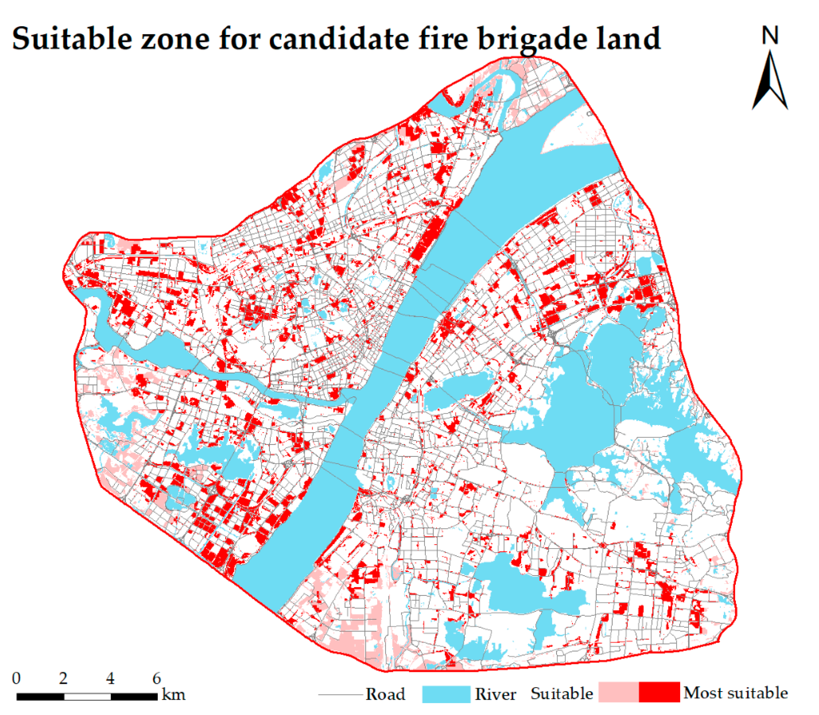
| Most suitable | 49.23 | 9.39 |
| Suitable | 18.08 | 3.45 |
| Unsuitable | 457.09 | 87.16 |
Publisher’s Note: MDPI stays neutral with regard to jurisdictional claims in published maps and institutional affiliations. |
© 2021 by the authors. Licensee MDPI, Basel, Switzerland. This article is an open access article distributed under the terms and conditions of the Creative Commons Attribution (CC BY) license (https://creativecommons.org/licenses/by/4.0/).
Share and Cite
Jiang, Y.; Lv, A.; Yan, Z.; Yang, Z. A GIS-Based Multi-Criterion Decision-Making Method to Select City Fire Brigade: A Case Study of Wuhan, China. ISPRS Int. J. Geo-Inf. 2021, 10, 777. https://doi.org/10.3390/ijgi10110777
Jiang Y, Lv A, Yan Z, Yang Z. A GIS-Based Multi-Criterion Decision-Making Method to Select City Fire Brigade: A Case Study of Wuhan, China. ISPRS International Journal of Geo-Information. 2021; 10(11):777. https://doi.org/10.3390/ijgi10110777
Chicago/Turabian StyleJiang, Yuncheng, Aifeng Lv, Zhigang Yan, and Zhen Yang. 2021. "A GIS-Based Multi-Criterion Decision-Making Method to Select City Fire Brigade: A Case Study of Wuhan, China" ISPRS International Journal of Geo-Information 10, no. 11: 777. https://doi.org/10.3390/ijgi10110777
APA StyleJiang, Y., Lv, A., Yan, Z., & Yang, Z. (2021). A GIS-Based Multi-Criterion Decision-Making Method to Select City Fire Brigade: A Case Study of Wuhan, China. ISPRS International Journal of Geo-Information, 10(11), 777. https://doi.org/10.3390/ijgi10110777