Review

A Survey of Algorithms and Systems for Evacuating People in Confined Spaces

1
Beijing Key Laboratory of Traffic Engineering, College of Metropolitan Transportation, Beijing University of Technology, Beijing 100124, China
2
Institute of Theoretical & Applied Informatics, Polish Academy of Sciences (IITIS-PAN), Bałtycka 5, 44-100 Gliwice, Poland
3
Imperial College London, London SW7 2BT, UK
*
Author to whom correspondence should be addressed.
Electronics 2019, 8(6), 711; https://doi.org/10.3390/electronics8060711
Submission received: 18 May 2019 / Revised: 10 June 2019 / Accepted: 19 June 2019 / Published: 23 June 2019
(This article belongs to the Section Microwave and Wireless Communications)

Abstract

:
The frequency, destruction and costs of natural and human-made disasters in modern highly-populated societies have resulted in research on emergency evacuation and wayfinding, which has drawn considerable attention. The subject is now a multidisciplinary area of research where information and communication technologies (ICT), and in particular the Internet of Things (IoT), have a significant impact on sensing and computing dynamic reactions that mitigate or prevent the worst outcomes of disasters. This paper offers state-of-the-art knowledge in this area so as to share ongoing research results, identify the research gaps and address the need for future research. We present a comprehensive review of research on emergency evacuation and wayfinding, focusing on the algorithmic and system design aspects. Starting from the history of emergency management research, we identify the emerging challenges concerning system optimisation, evacuee behaviour optimisation and data analysis, and the additional energy consumption by ICT equipment that operates the emergency management infrastructure.

1. Introduction

Research on evacuation wayfinding aims to develop methods and tools to direct evacuees out of hazardous areas in a timely and safe manner with the assistance of computer-aided systems. This multidisciplinary area that is based on the Internet of Things (IoT) proposes systems and algorithms that require advanced computing and sensing capabilities. It has to address the complexity of finding feasible or optimal solutions in highly-dynamic environments that are vulnerable to hazards, which can benefit from cutting-edge technologies, and has drawn considerable attention from both the industrial and academic communities.
The research in this area may be highly technical when the use of sensors and robots is considered to aid evacuees in finding exits in a highly-disorganised emergency environment [1,2,3]. It also needs to dig deeply into human behaviour due to fear and panic. Because of its very nature, much of the related work regarding the evaluation of these technologies and solutions must rely on detailed simulations [4] because of the repeatability, low cost and time efficiency of such tools.
Attempts at dealing with and managing disasters are deeply rooted in human history, and even folklore, owing to their impact on the social and economic aspects of societies. Many great disasters have been recorded in ancient literature such as the Deluge in the Bible. In ancient times, emergency management operations were often conducted in an unorganized, reactive manner. In the 20th Century, laws or policies began to be promulgated worldwide to provide financial assistance and investment after a disaster, or as a means to carry out preventive measures [5], to provide emergency management in a more organised, proactive fashion. From the 1950s onwards, with the nuclear threat during the Cold War and the development of computer technology, many efforts have been dedicated to computer-aided civil defence programs [6,7], which have motivated the development of systematic emergency management studies.
The current research efforts in this area can be generally grouped into two directions: evacuation wayfinding and emergency search and rescue planning. Evacuation wayfinding, also known as emergency evacuation planning, is the process of directing evacuees out of hazardous areas with the aid of real-time routing algorithms or using pre-deployed static plans that are based on prediction and analysis from evacuee behaviour models. Emergency search and rescue planning, on the other hand, focuses on rescuing immobilised and incapacitated evacuees that are trapped in hazardous areas with the assistance of task assignment or resource allocation algorithms.
This paper specifically reviews the developments and applications of the research field on evacuation wayfinding, from both the system design and algorithmic aspects. Owing to their open and inclusive nature, information and communication technologies (ICT) tend to influence, change, or even revolutionise research on emergency management, so that ICT now plays an important role in our survey, and a diagram explaining the structure of the paper is shown in Figure 1.
The remainder of the paper is organised as follows. We first summarize the research progress on the system design for evacuation wayfinding in Section 2. Then, we review the related research efforts in algorithm design in Section 3. Research trends and challenges are discussed in Section 4.1, and finally, we draw conclusions in Section 4.

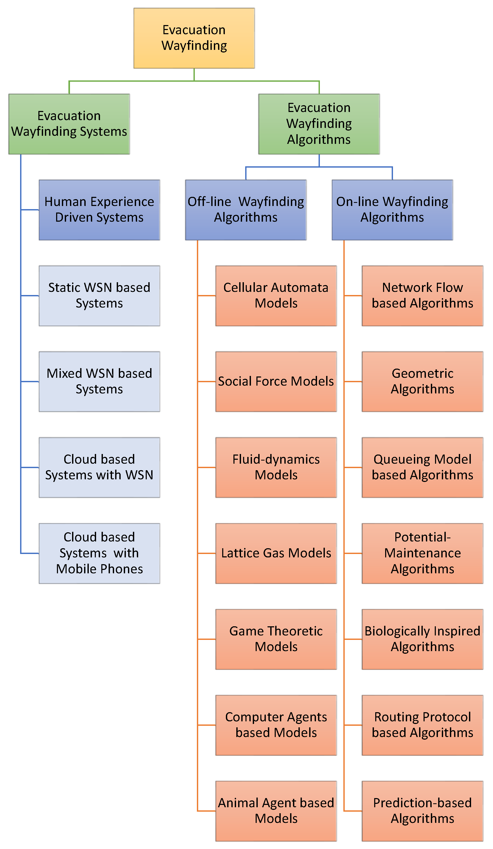
2. Evacuation Wayfinding Systems

The study of emergency evacuation, which was initially motivated by defence applications [6,7], has attracted much attention owing to the potential of losses in terms of human lives and property during a disaster. The path-finding process can be more challenging when an evacuation occurs in confined spaces, where the movement and choices of evacuees are restricted by the surrounding environment. Accompanying the advancement of computer technologies, emergency evacuation systems have experienced a few stages: from the original human experience-driven systems, to the currently booming in situ wireless sensor network-based wayfinding systems, towards the cloud-based wayfinding systems, which are still in their infancy.
The development of evacuation wayfinding systems is summarised in Table 1 in a chronological manner.

2.1. Human Experience Driven-Systems

Due to limitations in processing power, early evacuation wayfinding systems were commonly computer-aided information reporting systems to assist emergency managers in making decisions [8]. Associated evacuation wayfinding algorithms at that time normally used human experience or purely mathematical models to simplify an evacuation process and seek optimal solutions. Before the 1990s, research in this area was very limited. The research in [9] considered the evacuation planning problem as a minimum cost network flow problem that converts the original building graph into a time-expanded network; by solving the time-expanded network via a linear programming algorithm, evacuees can obtain optimal routes and achieve the shortest evacuation time. The study in [10] designed a graph-processing software to represent an underground mine as a graph-based evacuation network in conformity with proper ventilation requirements; each edge was assigned with a weight in terms of its distance to the source of hazard and fresh air intake, and Dijkstra’s shortest path algorithm was utilised to find the safest paths for evacuees. The work in [11] proposed a traffic monitoring and analysis system to predict the possible traffic jams for emergency planners during urban-scale evacuations; real-time traffic data were collected at roadside traffic-counting stations and transmitted to the system via conventional telephone lines; an evacuation simulation model was used to provide the locations and timing of occurrence of potential traffic bottlenecks. The research in [12] presented a human experience-driven emergency alarm system to facilitate emergency authorities to evacuate residents before the landfall of a hurricane; a “vertical evacuation” methodology was proposed to lower the evacuation time, and the issuing of “early evacuation orders” was believed to be critical in reducing fatalities. To improve the disaster response ability in accidents at nuclear power plants, the study in [13] proposed an evacuation plan for residents within 20 miles of the plant to flee when a radiation leakage occurred. The work in [14] designed a real-time emergency monitoring and response system for a nuclear power plant; the response decisions were based on discussions between experts at off-site emergency response centres.

2.2. Static Wireless Sensor Network-Based Systems

With the fast development of information and communication technology (ICT), as well as the advent of low-cost microelectronic devices, in the middle of the 1990s, research moved to the development of complex emergency cyber-physical-human systems to direct evacuees to exits with the aid of an on-site wireless sensor network (WSN), which itself may encounter communication uncertainties [15]. Until today, most of the state-of-the-art evacuation wayfinding systems and algorithms are still based on static WSNs. For instance, the research in [16] presented a static WSN-based distributed system to compute shortest safe paths for evacuees; this system employed a two-tiered architecture that contained a sensing sub-system and a decision sub-system. Since the full control of distributed information required maintaining consistency between the views related to different parts of the system [17], most proposals in the area of distributed wayfinding schemes assumed that decisions were made locally with the risk of inconsistent decisions. The study presented in [18] proposed a static WSN-based navigation system to direct evacuees with the variation of the temporally-ordered routing algorithm [19]; initially, exit sensors broadcast “initial packets” to assign each sensor with an “altitude” that was positively correlated with its distance to the nearest exit (sensors that were nearer to the exits possessed smaller altitudes than farther sensors); when a disaster occurs, the altitude of sensors inside a hazardous region would be increased and escape paths would be generated along sensors with higher altitudes to those with lower altitudes. The work in [20] utilised a self-organising WSN to guide a robot across a hazardous area; by using an “artificial potential field” [21], sensors could cooperatively generate a safe path without knowing the network topology.

2.3. Static and Mobile Wireless Sensor Network-Based Systems

Compared with static WSNs, mixed WSNs, which contain mobile nodes, can monitor uncovered areas of static sensors and are less prone to failures in harsh hazardous environments. Hence, some research has employed mixed WSNs to build emergency response systems. For instance, the studies in [22,23,24] proposed a resilient emergency support system (ESS) with the aid of opportunistic communications [25]. This system consisted of sensor nodes (SNs) and communication nodes (CNs). SNs can detect the hazard in their vicinity and inform the evacuees passing by of the location, while CNs are portable devices that are taken by occupants. The work in [26] presented an indoor autonomous wayfinding system composed of an intelligent evacuation sub-system (IES) for primary use and an opportunistic communication-based evacuation sub-system (OCES) for backup purposes; both sub-systems were supported by pre-installed sensors in the building; the IES utilised static decision nodes to guide evacuees in proximity, while the OCES employed mobile decision nodes carried by civilians to disseminate emergency messages and direct evacuees when the IDEmalfunctioned. The experimental results showed that the use of the OCES can considerably reduce the number of fatally-injured civilians during an evacuation process. With the increasing ubiquitousness of smart phones, which provide powerful sensing ability and suffer less from battery power limitations, many studies have integrated evacuees’ portable devices in evacuation wayfinding systems. For instance, the study in [27] proposed an emergency support framework that integrated a pre-deployed WSN with the existing mobile network infrastructure to guide evacuees out of a built environment; the framework, namely “CoWiSMoN”, employed both fixed sensors pre-installed in the building and mobile phones carried by evacuees to collect information and send to a quick rescue response centre via short-range wireless communication links or the mobile cellular network; moreover, a cognitive communication protocol that was optimised both of the network layer and data link layer was designed to ease the network congestion caused by the transmission of large volumes of sensory data and the degradation of communication quality during disasters. Similarly, the research in [28] presented an indoor emergency evacuation system composed of a sensor-data management sub-system and an indoor navigation sub-system; the sensor-data management sub-system gathered sensory information and could alert users and the building manager via mobile phones; the indoor navigation sub-system utilised radio beacon devices to estimate users’ position; each user carried a beacon receiver that could receive signals from beacons and transmit to the mobile phone via Bluetooth.

2.4. Integrated Systems Based on Wireless Sensor Networks and Cloud Computing

The major drawback of the WSN-based evacuation wayfinding systems is the limited computing capacity, which does not allow them to compute optimal evacuation plans in a timely manner so as to forward this information to evacuees in the presence of time-varying hazards. Hence, some evacuation wayfinding systems have integrated cloud computing technologies that are accessible via on-site WSN, to offload intensive computations to remote cloud servers. For instance, the research in [29] proposed a hazard surveillance system to detect unusual events in an environment and alert residents; the system was composed of a number of static sensors, several mobile sensors and an external cloud server; when static sensors detect unusually high temperatures, mobile sensors would be dispatched by the cloud server to take snapshots and upload to the server for further analysis; if a fire emergency was confirmed, the cloud server would notify the residents in the vicinity to evacuate. the study in [30] proposed a multi-cloud-based evacuation system that integrated an on-site WSN and remote cloud servers to calculate evacuation paths for users; when a disaster occurred, the system launched an instance for each user to compute the desired evacuation route; owing to the limited I/O capability of cloud providers, several cloud platforms were employed to launch sufficient instances for evacuees and a dynamic programming algorithm was used to minimise the overall latency and service maintenance cost of the system.

2.5. Integrated Systems Based on Smartphones and Cloud Computing

Although the hybrid emergency response systems that integrate on-site WSNs and off-site cloud servers can avoid the problems caused by the limited computing power of WSNs, the disadvantages of the limited battery life-time of the WSNs, as well as the high likelihood of system malfunction during an emergency still remain. Hence, many of the studies have replaced WSNs with smart phones carried by evacuees to build more flexible systems. For example, the work in [31] presented a building fire evacuation system that consisted of radio frequency identification (RFID) sensor tags, mobile phones with RFID readers and a back-end cloud server; since signals from the global positioning system were unavailable inside built environments, RFID sensor tags were used to record the temperature and location information; when a fire breaks out, mobile phones carried by evacuees would periodically sense the RFID signals and upload to the cloud server; the cloud server would then calculate the shortest safe route for each civilian with respect to the distance to the exit and the summed temperature along the route. The research in [32] proposed a smart cloud evacuation system (SCES) to post emergency messages and plans to residents in a built environment; in the front-end, a wireless intelligent sensor network (WISN) that integrated a WSN with smartphones was utilised to collect information; in the back-end, a cloud-based decision-making system was used to analyse the uploaded multimedia information (such as voice, text, images, etc.) and calculate escape paths with a 3D simulator.
The study in [33] proposed an infrastructure-less evacuation wayfinding system to guide evacuees out of hazardous buildings with the aid of smart phones carried by evacuees and an off-site cloud-based decision support system (CDSS); evacuees could locate themselves by taking a snapshot of pre-deployed landmarks (e.g., door signs) in the vicinity and uploading it to the CDSS for location identification; the CDSS computed congestion-aware paths with the shortest time to exits for evacuees based on their uploaded locations; evacuees were guided to exits in loose groups with the assistance of a combination of the social potential fields algorithm and a cognitive packet network-based algorithm.
To reduce the likelihood for the battery power of smart phones to drain during energy-hungry communication among smart phones and the CDSS, a power-aware communication protocol was also presented to balance the remaining battery power of smart phones by relaying sensory information via more energy-efficient short-range communication techniques before uploading to the cloud server through 3G. Indeed, there has also been substantial research in optimising the balance between rapid decision-making and the energy consumption needed to achieve fast decisions [34,35].

3. Evacuation Wayfinding Algorithms

As the kernel of an evacuation wayfinding system, many studies have concentrated on evacuation wayfinding algorithms that aim to guide evacuees out of hazardous areas safely and efficiently. Previous evacuation wayfinding algorithms can be divided into two types: off-line algorithms and on-line algorithms. Off-line algorithms focus on optimising the design of crowded sites and evaluating the overall clearance time for all evacuees before a disaster occurs. On the other hand, on-line algorithms aim to provide evacuation paths for evacuees in a real-time manner. The literature review for the two categories of algorithms is detailed as follows.

3.1. Off-Line Evacuation Wayfinding Algorithms

Since research has indicated that destructive crowd behaviours, such as clogging, pushing and trampling, can lead to serious fatalities [36], also owing to the absence of real evacuation data [37], off-line evacuation wayfinding algorithms have been dedicated to investigating and designing crowd behaviour models [38,39] to simulate the crowd movements in reality and prevent destructive crowd behaviours from occurring by improving the design of built environments. The crowd behaviour models of the off-line evacuation wayfinding algorithms can be classified into cellular automata models [40,41,42,43,44], social force models [36,45,46,47], fluid-dynamics models [48,49], lattice gas models [50,51,52], game theoretic models [53,54,55,56], computer agent-based models [57,58,59,60] and animal agent-based models [61,62].

3.1.1. Cellular Automata Model-Based Algorithms

Cellular automata models discretise a given structure into uniform “cells” where each cell can hold one person. This approach can precisely model the influence of an individual’s physical dimensions, but is ineffective at depicting the movement speed and direction, due to the discrete spatial structure [63]. The physical conditions and the movement patterns of evacuees are normally determined by a set of local rules at each cell (one drawback is that it is relatively difficult to customise the physical attributes of each individual civilian). Since this model can effectively mimic the interactions between the environments and the pedestrians, many studies have utilised this microscopic model to simulate the pedestrian dynamics during evacuations in the last two decades. In these models, evacuees are considered as either homogeneous with identical physical attributes (e.g., gender, age, mobility, psychology) or heterogeneous individuals with different characteristics. For instance, the research in [64] utilised a homogeneous cellular automata model to investigate the exit dynamics of evacuees in a room with different numbers of exits; the arching behaviour, which is a signature of jamming that happens when the exits are overused, was observed near the exits; a “power law behaviour” was also found: when the exit door can evacuate more than one evacuee at a time, the evacuees will escape from the room in bursts of various sizes. In [43], a heterogeneous cellular automata model mimicked the evacuation process in a retirement house; evacuees initially belonged to three groups (middle-aged people, nursing staff and older people), and groups were also formed dynamically due to the follow-the-leader effect. In [44], grouping behaviours in evacuations were induced by introducing “bosons” into cells of the floor field cellular automaton [65]; bosons were placed by evacuees as markers to increase the probability for other group members to reach some particular cells. The resulting simulations indicated that the evacuation time decreased with the increasing number of groups.

3.1.2. Social Force Model-Based Algorithms

The research in [45] first proposed that the motion of a crowd of pedestrians was subject to “social forces”; in the social force model, the motion of a pedestrian is mainly affected by the destination, the repulsive forces from other objects (e.g., the pedestrian keeps a certain distance away from other pedestrians or obstacles) and the attractive forces from other objects (e.g., the pedestrian is attracted by friends or window displays); a “direction dependent weight” was introduced into the model since the objects behind a pedestrian had a weaker effect on the pedestrian; a “fluctuation effect” was also integrated into the model to simulate the random movement behaviours or deliberate deviations from usual motion rules. The study in [66] combined the social force model with a counter-propagation neural network model [67] to mimic crowd behaviours in a panic; the personality of evacuees was expressed as impatient and patient. the velocity and the action of evacuees was determined by the social force model and the neural network model, respectively; the neural network had four inputs: the personality of an evacuee, the deviation between the desired speed and real speed, the space on the left side of the evacuee and the space on the right side of the evacuee; the output of the network was the action of the evacuee: follow the person in front, evade the front person from the left side and evade the front person from the right side. The research in [46] utilised the social force model to investigate the pedestrian evacuation dynamics in a room with an exit; experimental results showed that if evacuees moved at the low desired velocities, the faster the evacuees moved, the faster they would evacuate the room; however, if evacuees moved at the high desired velocities, the “faster is slower” effect, that the faster the evacuees wish to move the slower they can escape from the room, was observed and analysed.

3.1.3. Fluid-Dynamics Model-Based Algorithms

Fluid-dynamics models imitate evacuee flows as fluids to study the density and speed adaptation during an evacuation process. Compared with microscopic models, the macroscopic fluid-dynamics models are better at simulating and analysing the behaviours of large crowds. For instance, the research in [68] derived several equations that governed the motion of a pedestrian flow from the “continuity equation” of fluid mechanics in physics; the proposed equations led to two possible regimes of pedestrian flow: the fast-moving, low-density “supercritical” flow in which disturbances spread within the flow and the slow-moving high density “subcritical” flow in which disturbances are swept along by the flow; several partial differential equations that govern the crowd behaviours of a flow that contains different types of pedestrian were also studied; a pedestrian type was determined by the destination, walking speed and perception; the analysis and experimental results showed that pedestrians tended to reach each immediate destination in the minimum time rather than arriving at all destinations in the overall minimum time. The study in [69] presented a continuum model to investigate the relation between evacuee density and walking speed during a process of evacuees leaving a corridor through a door; the proposed model was based on the Lighthill–Whitham [70] and Richards [71] model, which is used to simulate vehicle flows; specifically, this model describes the decrease in the outflow through a door caused by the panic “over-compression” effect of evacuees in front of the door; the analytical results indicated that the rise of panic can dramatically decrease the outflow of evacuees when the door is narrow.

3.1.4. Lattice Gas Model-Based Algorithms

Since a pedestrian flow is a many-body system [72] that is composed of strongly-interacting persons, lattice gas models that consider pedestrians as particles on the square lattices have attracted attention since the 1980s. The research in [51] utilised a lattice gas model to simulate the process of a pedestrian flow evacuating a hall; the hall was represented by square lattices, and evacuees were randomly distributed over the lattices; each evacuee could either hold still or move in four directions: forward, backward, left and right; evacuees moved in the preferential direction with no back step and could not overlap on lattices occupied by other evacuees; different dynamical patterns such as arching, flattening and pitting were observed in computer simulations; experimental results indicated that the dynamical phase transition from the choking flow to the decaying flow occurred at a critical time. The study in [52] employed a lattice gas model to study the evacuation time for a crowd to escape from a hall through a single exit; evacuees were modelled as biased random walkers and moved in preferential directions; the hall was represented by square lattices, and each square lattice could contain contain up to one evacuee at a time; the spatio-temporal distribution of evacuation time of evacuees was derived from simulations; the experimental results showed that the evacuation time of an evacuee depended highly on its initial position within the hall; the effects of the exit width, initial population density and urgency level were also investigated in the experiments.

3.1.5. Game Theoretic Model-Based Algorithms

To model the behavioural reactions of the individuals during an evacuation process explicitly, especially the cooperative and competitive behaviours [73], many of the studies have utilised game theory to mimic the interactive decision-making and strategy-adapting among evacuees. For instance, the research in [54] employed the non-cooperative game theory [74] to mimic evacuees’ exit selection process when an emergency occurred in a building with multiple exits; the procedure of the algorithm consisted of two steps: in the first step, all evacuees were considered as a “whole entity”, which aimed at minimising the overall evacuation time, while a “virtual entity” was used to maximise the overall evacuation time by imposing the blockage influence; hence, a two-player zero sum game was envisaged between the evacuees and the virtual entity; the optimal strategy was found when a Nash equilibrium [75] was achieved via optimising the probabilities for the evacuees to choose each exit and the possibilities for the virtual entity to pick each exit (to generate congestion); in the second step, the decision of each individual evacuee was determined by calibrating the evacuees’ probabilistic choices in terms of evacuees’ distance to exits; this was because, in reality, an evacuee will not pick a farther exit unless the nearer exit is congested. The study in [56] utilised a game-theoretical model to investigate the competitive and cooperative behaviours during an evacuation process from a large single room with one exit; during the evacuation process, when N evacuees wished to occupy the same desired position, the conflict among evacuees led to a N N game; each evacuee could choose to either compete or cooperate: if all the evacuees chose to cooperate, then they would all reach the desired position; if all the evacuees were competitive, they would all be blocked at the initial position; if one evacuee chose to compete and the rest were in a state of cooperation, only the competitive evacuee could reach the desired position; the simulation results showed that: (1) with the increasing urgency of emergency, the cooperation among evacuees decreased; (2) higher cooperation frequency resulted in shorter overall evacuation time; (3) the imitation behaviours among evacuees enhanced the cooperation level, but reduced the efficiency of the evacuation process.

3.1.6. Computer Agent-Based Algorithms

Algorithms based on pure mathematical models have difficulty in fully representing and capturing the dynamics of an evacuation process. Hence, the agent-based algorithms, which normally represent a hazardous environment with a number of autonomous decision-making virtual agents, have drawn considerable attentions in recent years. One major advantage of the agent-based algorithms is the ability to evolve and learn, which can lead to unanticipated behaviours during simulations. This characteristic makes the agent-based algorithms a canonical approach to mimic the counterintuitive emergent phenomena [57]. For instance, the research in [58] utilised a multi-agent framework to simulate a metro system in the case of a tunnel fire; the passengers and metro personnel, the technological system, as well as the fire and smoke were simulated by separate agents and co-evolved in an interactive manner; an effective evacuation plan was designed by varying environmental factors, such as the number of passengers on the train, the time cost for the train driver to open the doors, etc.; with the aid of the multi-agent computer simulations, which could test different scenarios, the emergency personnel could quickly customise a rescue plan when a disaster occurred. The study in [60] presented a prototype multi-agent simulation system that could build a virtual environment with autonomous agents for safe egress analysis; the proposed system consisted of a geometric engine that represented the physical environment with AutoCAD, a population generator that could produce evacuee agents with diverse age, mobility, etc., a global database, which maintained all the state information of agents, an events’ recorder that captured the behaviours of evacuee agents and a visualiser, which displayed the movement of evacuees, a crowd simulation engine that was assigned to each evacuee agent to manage the individual behaviour in terms of the perception-action approach [76]; each evacuee agent was modelled to make decisions based on three basic conventions: instinct, experience and bounded rationality [77]; some emergent behaviours such as competitive, queueing and herding were observed in the simulation.

3.1.7. Animal Agent-Based Algorithms

Owning to the scarcity of human emergent behavioural data and the difficulty in conducting genuine emergency evacuation experiments, the studies of emergent behaviours have largely depended on simulations. Hence, in recent years, animals have been used in escape panic experiments to study crowd evacuation. For example, the research in [61] employed mice to study an indoor evacuation process; mice were released into a rectangular container (to simulate a large single room) filled with tap water and were left to swim towards a dry platform; an exit was placed between the wet and dry areas to simulate the door of the single room; the effect of exit width and exit number on the mouse escape rate was investigated over different experimental sessions, which were recorded with a digital video camera; the experiments demonstrated some well-known behaviours of a panicking crowd: when the exit width approximately was equal to the size of a mouse, the diffusive evacuation flow was observed; when the exit width became larger, the mice evacuated throughout the exit in bursts of different sizes that yield the power-law distributions depending on the exit width. The work in [62] employed a species of Cuban leafcutter ants called Atta insularis to investigate the effect of panic-induced herding on an evacuation process from a two-exit room; ants were introduced into a circular acrylic cell with two exits symmetrically situated at the left and right; in the first experiment, which simulated a normal evacuation process, when the ants were placed into the cell, the two exits were opened synchronously, so that the ants could escape; in the second experiment, which mimicked an emergency evacuation process, the only difference from the first experiment was injecting a dose of insect-repelling liquid to generate a panic before opening the exits; the experimental results showed that ants escaped from both exits in approximately equal proportions in normal conditions, but preferred one of the exits in emergency conditions; the experiments demonstrated the theoretical prediction that the herding behaviour in confined spaces can generate a non-symmetrical use of two identical exit doors; in addition, the observed evacuation dynamics were reproduced with a computer model inspired by [36].

3.2. On-Line Evacuation Wayfinding Algorithms

Contrary to off-line evacuation wayfinding algorithms, which aim at optimising the design of crowded sites or generating evacuation plans for facility managers via developing various crowd behaviour models and computer simulations, on-line evacuation wayfinding concentrates on combining mathematical models [78] or algorithms [2,79] with underlying sensing, communication and computational devices to guide evacuees out of hazardous environments in a real-time manner.
Since on-line evacuation wayfinding algorithms require real-time information exchanges with the hazardous environment, these algorithms are usually integrated into evacuation wayfinding systems. With the development of evacuation wayfinding systems, which are detailed in Section 2, various evacuation wayfinding algorithms have been proposed such as network flow-based algorithms [9,80,81,82,83], geometric algorithms [84,85], queueing model-based algorithms [86,87,88,89,90,91,92], potential-maintenance algorithms [18,20,93], biologically-inspired algorithms [94,95,96], routing protocol-based algorithms [23,97,98,99] and prediction-based algorithms [100,101,102,103,104].

3.2.1. Network Flow-Based Algorithms

Network flow-based algorithms consider the evacuation planning problem as a minimum cost network flow problem [105,106]. Commonly, this type of algorithm first predicts the upper bound of the overall evacuation time and then converts the original building model into a time-expanded network by duplicating the original network for each discrete time unit. After that, linear programming or heuristic algorithms are utilised to compute the optimal evacuation plan. This type of approach can achieve the optimal solution, but normally does not take the spreading of the hazard into consideration. For instance, the work in [9] utilised a dynamic network optimisation model to minimise the overall evacuation time and prevent “bottlenecks” from occurring in a large building; the building was represented by a graph model composed of nodes and arcs; the capacity of a node was determined by dividing the space area of the node by the typical space occupied by an evacuee; the capacity of an arc, which was defined as the maximum number of evacuees that were allowed to traverse the arc per unit time, was determined by the passageway width; the graph model was expanded into a time-expanded network by duplicating the original graph model over T time periods, where T was determined by dividing the approximate evacuation time T e by the length of a time period (10 s); to reduce the computational complexity and ensure the existence of a feasible solution, the minimum feasible building evacuation time T e was determined by the proposed bisection search algorithm; the time-expanded network was solved via a large-scale dynamic transshipment algorithm from the GNET program [107]. Since the search complexity of a time-expanded graph grows exponentially with the increase of the time bound T, the studies in [108,109] developed a polynomial time algorithm to solve the evacuation problem with a fixed number of sources and exits; the evacuation problem was converted to a quickest flow problem, which aimed to send a specific amount of flows from sources to sinks in the shortest time; the building model was represented by a graph with integral transit times and capacities on the edges; the evacuees flows were represented by the temporally-repeated flows proposed in [105] rather than static flows in a time-expanded network; the quickest flow problem with multiple sources and sinks was then transferred to a lexicographic maximum dynamic flow problem and could be solved by using the algorithms presented in [110,111]. Since linear programming algorithms that utilise time-expanded networks to calculate optimal evacuation plans can suffer from high computational cost, the work in [82,83] proposed a heuristic-based algorithm called capacity constrained route planner (CCRP) to produce sub-optimal evacuation plans in a time-efficient manner; rather than transforming the original evacuation network into a time-expanded network, CCRP employs Dijkstra’s shortest path algorithm [112] to search only the original evacuation network and calculate the quickest routes for evacuees; CCRP first searches the route with the shortest arrival time from any source node to any destination node in terms of path length, previous reservations and possible waiting time; then it allocates evacuees to this route with respect to the capacity of the route; the CCRP algorithm will iterate the above two steps until all the evacuees reach the exits. These approaches can theoretically solve optimal routes with the shortest time to exits by avoiding congestion. However, to achieve shortest time to exit, evacuees must accurately follow the suggested paths and reach every node on schedule and may even wait a certain time at a node to avoid congestion. This is impractical in a real evacuation process. Moreover, these approaches suffer from high computational complexity because the time-expanded network will contain at least ( N + 1 ) T nodes for a graph with N nodes and an upper bound of evacuation time T. In addition, as previously mentioned, the spreading of the hazard was not considered in these approaches.

3.2.2. Geometric Algorithms

Geometric algorithms normally use a graph model to represent a hazardous environment and take advantage of the unique properties of geometric graphs to calculate safe egress paths for evacuees. For instance, the research in [84] adopted the localized Delaunay triangulation method [113,114] to partition a wireless sensor network into triangular areas and construct area-to-area egress paths with the aid of a distributed navigation protocol; each sensor, which was the shared vertex of all the adjacent triangles, maintained the node ID, hops to the exits and the sensed hazard level (temperature) of the neighbour sensors; the direction of an egress path was generated from vertices with a larger hop count to the exit to vertices with a smaller hop count; the safety level of a triangle area was classified into three colour-coded levels (red “high”, yellow “moderate” and green “low”) by comparing the average detected temperature of the associated sensors with a pre-set temperature threshold; in built environments with multiple exits, additional wireless access points (AP) that can cover the whole environment were deployed in the vicinity of each exit to count the number of evacuees nearby, and a load-dispersion algorithm was employed to distribute evacuees by limiting the number of users per exit. The research in [85] proposed a WSN-based evacuation wayfinding system to guide evacuees without the aid of any pre-knowledge of sensor or user locations; the process of navigating evacuees to the exit contained three stage: firstly, a road map was generated as the backbone route; secondly, the exit was connected to the backbone route via a virtual power field algorithm; thirdly, evacuees were directed to the backbone route via the virtual power field algorithm and then followed the backbone route all the way to the exit; the road map was constructed via concatenating the medial axis of the boundary of any two safe areas; as was proven in [115], the medial axes of the safe regions, which can form continuous curve graphs, retained the topological and geometric features of the safe areas; in the virtual power field algorithm, the virtual power of a point was inversely proportional to its distance from the hazard; the route from any point to the backbone route would follow the most descending direction of the virtual power field; owing to the expanding or shrinking of the hazard, the dangerous areas varied during the evacuation process; hence, a local road map updating algorithm was proposed to rebuild the backbone route of the affected areas instead of reconstructing the entire backbone route when a variation of the dangerous areas was detected. However, the effectiveness of these approaches highly depended on the topology of the deployed wireless sensor network. The change of the topology would induce redeployment and re-calibration of these algorithms.

3.2.3. Queueing Model-Based Algorithms

Owing to the stochastic, highly transient and nonlinear nature of an evacuation process, queueing models have been proven as a useful tool to capture and analyse the dynamics of evacuees [116]. Normally, by treating significant locations such as doorways or staircases as “servers”, queueing model-based approaches [117], which generalise the Markovian models of computer systems [118], transfer building graphs to a queueing network or a number of isolated “queues” to estimate congestion and evacuation delays. For instance, the process of pedestrians traversing a corridor or stairwell was analysed as a state-dependent process in [86]; a M / G / C / C state-dependent queue model was utilised to estimate the congestion delays at corridors or stairwells and the overall evacuation time of an evacuation process; the pedestrian flows were classified into three categories: uni-directional flow, bi-directional flow and multi-directional flow; the relationship between the crowd density and the mean walking velocity of evacuees in the three categories of pedestrian flows were derived from [119]; the capacity of a corridor or stairwell was calculated based on [120], which indicated that the evacuee flow would cease to move when the population density reached five evacuees per square meter; the state-dependent service rate of the three categories of pedestrian flows can be calculated in terms of the mean walking speed and the corridor capacity; finally, the time cost for an evacuee flow to traverse a corridor or a stairwell can be computed by the mean value analysis (MVA) algorithm introduced in [121]. To ensure no corridors would be blocked during an evacuation process in a built environment, the work in [87] considered the evacuation planning problem as a service and capacity allocation (SCA) problem and searched for the smallest capacity of each corridor via modelling the building as a M / G / c / c queueing network; the M / G / c / c queueing network was employed to calculate the average queue length at each corridor with the following steps: ( 1 ) the average walking speed V n of n evacuees in a corridor was calculated by the equations derived from the congestion model proposed in [122]; ( 2 ) the state-dependent service rate f ( n ) with n evacuees in a corridor could be computed by f ( n ) = V n V 1 , where V 1 is the average speed of a lone evacuee; ( 3 ) term p n , which is the probability of n evacuees in a corridor, could be calculated by the equations derived from [123]; ( 4 ) the average queue length of a corridor could then be computed by L = n = 1 c n p n ; to analyse the smallest capacity of each individual corridor, the generalised expansion method [124,125] was used to expand the M / G / c / c queueing network into an equivalent Jackson network via adding an artificial holding node in front of each finite queue to register the blocked evacuees due to capacity limitation; After decomposing the queueing network, a local search algorithm inspired by [126] was used to search for the smallest feasible capacity of each queue. Similarly, the studies in [89,127] utilised a M / G / c / c queue model to simulate the dynamics and predict the overall evacuation time of an egress process without hazard; rooms, corridors and stairways were modelled as queues in which the service rate depended on the evacuee density; doors, exits and gateways were imitated as queues in which the service rate depended on not only the evacuee density, but also the faster-is-slower effect [36] and the crowd impatience [128]; to validate the effectiveness of the queue system, a discrete-event simulation model was implemented via the SimEvents toolbox in the MATLAB/Simulink environment, and experimental results showed that the egress time of evacuees in simulations highly matched with the prediction of the proposed queueing model. Rather than simulating all the building components as M / G / c / c queues, the research in [129] modelled doorways that can pass one person at a time as M / M / 1 queues; on the other hand, corridors or stairs were modelled as M / G / queues, in which the infinite number of servers implied that no congestion occurred in corridors or stairs. Rather than using traditional closed network models that suffer from high computational costs, the study in [90] proposed a computationally-efficient open network model with product form to predict the congestion level at each point of interest (PoI) and the overall evacuation time with respect to average arrival and departure rates at each observation point; by assuming Poisson arrivals of evacuees at each originating location, uni-directional corridors that allowed at most one evacuee to pass at a time and exponentially traversal delays at each corridor, a M / M / 1 queue model was established to mimic each corridor; hence, the average delay at a corridor could be calculated by 1 μ - λ , where 1 μ represents the average traversal time of a corridor and λ represents the average arrival rate of evacuees at a corridor; the average traversal time of a path can be calculated by summing the average delay of each corridor on it. Rather than considering each significant location (such as a doorway or staircase) as an independent “queue” and then using either the limiting probabilities for the number of customers in an M/G/C/C state-dependent queueing model [130] or steady-state solutions [90] to analyse the number of evacuees at the location, the work in [91] treated all the significant locations in the designated area as a “queueing network” by considering the interaction effects of various evacuees among linked “queues”; in this study, to predict the time cost T for an evacuee to traverse a path, a G-network model [131] was employed to compute the utilisation rate of each node and edge periodically under the combined impact of a specific routing scheme and panic behaviours; Little’s formula was then used to calculate the average delay of each node and edge; finally, T can be calculated by summing the average latency of each node and edge on it. The research in [92] proposed an urban-scale evacuation wayfinding system to guide vehicles to safe zones in the aftermath of a disaster in a latency- and energy-efficient manner; a G-network model [132] was utilised to analyse and capture the dynamics of vehicles under the joint influence of interactions among individual vehicles and the re-routing decisions from the navigation system; by using this G-network model, the average number of vehicles and the average traversal time at each intersection or road segment could be calculated; hence, the total average delay experienced by a vehicle and the total fuel consumption in the network could be described by a goal function; finally, a gradient descent algorithm was utilised to reduce the time and fuel cost (minimise the goal function) by optimising the probabilistic choices of linked road segments at each intersection.

3.2.4. Potential-Maintenance Algorithms

Potential-based algorithms normally can dynamically develop navigation paths by assigning attractive or repulsive potentials to the exits and hazards, and the evacuees move as a result of the net attraction-repulsion in various directions. For instance, the research in [20] presented a self-organizing sensor network to guide users such as robots, evacuees or unmanned vehicles out of a hazardous environment along the safest paths by using “artificial potential fields” [21]: when a sensor detected a hazard, it broadcast emergent messages including sensor ID, number of hops from the arrived sensor ( N h ) to other sensors; when a sensor received multiple emergent messages from the same hazardous sensor, it would keep the smallest N h ; the potential value of a sensor generated by a hazardous sensor was calculated by 1 N h 2 ; hence, the overall potential value of the sensor was computed by summing the potential value generated by each hazardous sensor; in this way, an attractive force was generated by the destination to pull the user, while repulsive forces were generated by the dangerous zones to push the user away from them; the safest path was generated by following the most descending direction of the potential field; experiments were conducted on a test bed with 50 Mote MOT300 sensors [133], and the results indicated that the algorithm could successfully direct the objects to the destination; however, multiple destinations may have a negative impact on the efficiency of reaching the exits as the users move under the actuation of artificial forces.
Moreover, the convergence time for network stabilization was relatively long due to the effect of data loss, asymmetric connection and network congestion. The study in [18] proposed a temporally-ordered routing algorithm-based [19] multi-path routing protocol to route evacuees to exits through safest paths; a navigation map was manually defined during the deployment process to avoid impractical paths; in the initialisation phase, each sensor was assigned with an altitude with respect to its hops to the nearest exit: sensors nearer to the exits were assigned with smaller altitudes, while sensors farther from the exits were allocated with larger altitudes; when an emergency event was detected, a sensor s i within the hazardous regions would update its altitude in terms of the altitude of s i before and after the update, the shortest hop distance between s i and the hazardous sensor and the shortest hop distance between s i and the exit; a hazardous region was constructed by sensors within a predefined hop distance from the hazardous sensor; egress routes were generated from sensors with a higher level from the ground; therefore, more elevated hazard sensors could ensure evacuees bypass the hazardous regions. The work in [134] extended the algorithm in [18] to a 3D environment and divided the sensors into normal sensors, exit sensors and stair sensors in terms of location; if no available path to exits could be discovered, evacuees would be directed to rooftops and wait for rescue. However, multiple destinations (exits) may affect the efficiency of reaching the exits as the users moved under the actuation of artificial forces. Moreover, the convergence time for network stabilization was relatively long due to the effect of the information synchronization, asymmetric connection and network congestion.

3.2.5. Biologically-Inspired Algorithms

Millions of years of evolution have made animal’s foraging behaviours become near-optimal solutions of autonomous search and path-finding [135]. Biologically-inspired approaches, which are inspired by simple, but reliable natural mechanisms, employ heuristics to search optimal routes in a computationally-efficient manner. For instance, a feed-forward neural network model was adopted for a wireless sensor-actuator network (WSAN) for evacuation routing in [95]; all physical nodes in the WSAN deployed a neural network with an identical topology: an input layer, a hidden layer and an output layer; the input layer received the latest two coordinates of a pedestrian, and a suggested direction was subsequently generated by the output layer; the neural networks were trained with a back-propagation algorithm [136] in standard situations and were deactivated when an emergency happened; hence evacuees would be directed to exits over their normal walking paths; however, back-propagation algorithms suffer from a slow learning rate and easily converge to local minima; furthermore, this model cannot react to the spreading of a hazard. The study in [96] employed a genetic algorithm [137,138] to minimise the total evacuation time, travel distance and number of congestions encountered during an evacuation process. Non-domination sorting [139] was used as no a priori knowledge was available to determine the weight of the three goals; the initial “chromosomes” were paths found by the k-th shortest path algorithm [140] and were incrementally evolved to feasible solutions through crossover and mutation with respect to the path length, congestion level and hazard intensity. As an evolutionary approach, this algorithm had advantages in solving the multi-objective optimization problem (MOP) [141]; however, the computational overhead was relatively high due to the path-finding and the evolution process.
The research in [142] adopted a variation of particle swarm optimization (PSO) to search for routes and adjust velocity during evacuations; occupants were viewed as particles to search exits; once an exit was discovered, all the other particles would move towards it while keeping their moving inertia to expand the searching space; if more than one exit was found, particles would choose the nearest exit as the destination; nevertheless, using occupants directly to explore paths may cause severe injuries and fatalities; meanwhile, this algorithm may induce serious congestion and oscillation problems. Inspired by the bee colony foraging behaviour, the work in [143] used bee colony optimization [144] to displace evacuees in hazardous areas to safe areas during an emergency evacuation; hives, food sources and bees represented safe areas, hazardous areas and evacuees, respectively; evacuees selected a safe area with regard to “attractiveness”, which was determined by the distance to the area and the distribution of people in hazardous areas; once an evacuee determined a target, it would recruit other evacuees by sharing information of the devoted area; this algorithm obtained a robust evacuation plan at the expense of relatively high communication overhead.

3.2.6. Routing Protocol-Based Algorithms

Since many of the current emergency response systems are based on wireless sensor networks, routing protocols that were initially used for packet networks have been borrowed or adapted to direct evacuees and improve communication quality in hazardous environments. For instance, the research in [97] presented an emergency support system built on top of a WSN to guide evacuees out of a confined space in a real-time fashion; the embedded evacuation wayfinding algorithm was inspired by the cognitive packet network routing protocol [145,146], which was initially designed for large-scale packet networks; different from the original CPN that contains three types of packets: smart packets (SPs), dumb packets (DPs) and acknowledgements (ACKs), this variant only consists of SPs and ACKs; SPs are sent from each sensor node in the WSN to search for egress paths and collect hazard information in a distribute manner with their predefined goals; when an SP reached an exit, which means an egress path has been discovered, an ACK would be generated and bring back the ID and the hazard information of each sensor node along the path to the source node that emitted the SP; when the ACK reached the source node, it would update the QoS level of the discovered path by using a rolling average mechanism, which summed the newly-discovered QoS and previously-stored value in a weighted manner; in attempting to efficiently find the route with the best quality of service (QoS), when an SP arrived at a sensor node, it would decide its next hop by the m-sensible routing algorithm [147]; a QoS metric was defined as sensitive if its value was affected by the traffic through the path, such as congestion level; on the other hand, a QoS metric was insensitive if its value was independent of the traffic assigned to the path, such as path length or number of hops on a path; m-sensible routing algorithm calculated the probabilistic choices of all the neighbour nodes based on the QoS information brought back by the previous SPs; hence, future SPs decided their next hop by yielding the probabilistic choices of the neighbour nodes obtained by the m-sensible policy; it is proven in [147] that the QoS increased with the increase of term m; hence, an m + 1 -sensible routing policy provided better QoS on the average than the m-sensible policy; to enhance the stabilisation of network, a predefined “measurement discard threshold” was set to discard the reported QoS (effective length) that was smaller than the threshold.
Since communications that are essential in an evacuation process can easily malfunction due to the hazard, the research in [23] proposed a resilient emergency support system (ESS) to disseminate emergency messages among evacuees and direct evacuees out of a confined space with the aid of opportunistic communications (Oppcomms) [22]. The proposed system was composed of pre-deployed sensor nodes (SNs) to collect environmental information and mobile communication nodes (CNs), which were portable devices carried by evacuees; to locate evacuees, each SN contained a location tag and could periodically send a location message (LM) to CNs in proximity; when an SN detected a hazard, an emergency message (EM) would be generated and broadcast to CNs carried by evacuees in the vicinity by using the epidemic routing [148]; the EM would be stored in these CNs and forwarded to other CNs in contact by the “store-carry-forward” paradigm [25] during the movement of the evacuees; to guide evacuees, each CN stored the building graph in its local storage and updated the edge costs when receiving an EM. Dijkstra’s shortest path algorithm was triggered to calculate the shortest safest path when the graph was updated; experimental results indicated that the proposed system was robust to network failures during an emergency.
Since Oppcomms are susceptible to malicious attacks such as flooding or denial of service, an extended study [149] proposed a defence mechanism that used a combination of identity-based signatures (IBS) and content-based message verification to detect malicious nodes. However, network routing protocol-based algorithms normally make decisions based on the collected sensory information rather than the predicted situation of a path. Therefore, when evacuees traverse that path, the situation could have changed owing to the highly dynamic nature of an evacuation process, which normally induces a delayed feedback loop between living sensory data and routing decisions. Similar to [97], the research in [98] also borrowed the concept of the cognitive packet network to calculate evacuation paths for evacuees with the aid of an on-site WSN in a distributed manner; however, rather than using the m-sensible routing algorithm, the random neural network (RNN) [150,151,152] and its learning algorithm [153] were used as in decision-making for the SPs to explore the environment; each sensor node in the WSN was considered as a CPN node, in which an RNN was deployed to direct the passing-by SPs and a mailbox was used to store the discovered paths and the associated QoS measurements; the RNN consisted of neurons that were associated with each potential forwarding direction of SPs; each neuron possessed an excitation probability to indicate the quality of the forwarding direction, and the neuron with the highest excitation probability corresponded to the optimal forwarding direction; when an evacuation process began, CPN nodes continuously sent out SPs or relay SPs from other CPN nodes; when a SP reached a CPN node, it could either select the forwarding direction corresponding to the most excited neuron or drift randomly to search for new routes; as a SP arrives at an exit, an ACK would be generated to backtrack the discovered route in a loop-free manner; when an ACK reaches a CPN node, the training process of the local RNN would be triggered, and the excitation probability of each neuron would be updated based on the learning mechanism of the RNN; the discovered routes would be stored in the local mailbox and sorted by quality; evacuees in the vicinity of a sensor node always would be transferred the top-ranked route as their evacuation route; since each SP could gain “experience” from previous SPs, the CPN could rapidly discover the optimal or near-optimal evacuation routes by emitting very few packets [154].
The studies in [99,155] extended the work in [98] and made use of the feature of CPN to develop a multi-path routing algorithm for different categories of evacuees (prime-aged people, aged people, children or ill people and disabled people in electric-powered wheelchairs) with respect to their specific requirements; since each SP could search a distinct path based on its pre-defined goal function, during the evacuation process, various types of SPs were sent out to search distance-oriented paths, time-oriented paths, safety-oriented paths and energy efficiency-oriented paths for the associated evacuees. On top of the work in [155], the work in [156] designed a cooperative strategy that divided evacuees into health-oriented evacuees and evacuation time-oriented evacuees and could adjust the routing strategy of evacuees when their “virtual health value” fulfilled a certain condition; the use of the strategy was proven to be more sensitive and adaptive to sudden changes in the hazard environment such as abrupt congestion or injury of civilians.

3.2.7. Prediction-Based Algorithms

By inferring the spreading rate and direction of the hazards, prediction-based algorithms predict the future status in the hazardous areas and reduce the fatality rate by avoid that evacuees traverse paths with a high potential risk level. For instance, the research in [100] proposed a Monte Carlo stochastic model to predict the spreading of the fire hazard and the movement of evacuees during an evacuation process; the targeted building was represented by two graph models composed of nodes (compartments) and edges (passageways), one for fire spread modelling and the other for occupant egress modelling; a discrete hazard function based on Bernoulli trials was used to mimic the propagation of the fire; a Bernoulli trial, which is a random experiment with two possible results: “success” and “failure”, and the probability of success or failure is constant whenever the experiment is conducted, was performed at each time step to mimic the transmission of fire from one compartment to another. Each edge of the two graph models was associated with a “defective” random variable to represent the time cost for evacuees or the fire hazard to traverse this edge. These defective random variables, which took the value “infinity” with non-zero probability, were used to simulate the phenomena such as evacuees cannot reach the next node owing to capacity limitation, fire or an obstruction that impedes reaching the next node.
The study in [101] proposed a WSN based distributed navigation algorithm to search for the safest routes for evacuees by maximising the time an evacuee would remain ahead of the hazard while traversing the route. Each sensor would maintain two weighted graphs of the built environment, a “hazard graph” and a “navigation graph”. In the hazard graph, nodes represented the locations of sensor, while edges represented the possible movement directions of the hazard (for example, the hazard may spread through walls or along corridors); the weight of an edge was the shortest time for the hazard to propagate along the edge, and this information could be obtained from off-line hazard simulations [157] or estimated by emergency specialists. The nodes of the graph represented the sensor locations, while edges represented the possible movement directions of evacuees; the weight of an edge was the longest time for an evacuee to traverse the edge. When a fire breaks out, sensors that detected the hazard would broadcast the fire source location over the sensor network, then each sensor calculated the safest path to exit by maximising the overall difference in time between an evacuee arriving at each node on a path and the hazard reaching these nodes. Since it is difficult for fire-fighters to be aware of the actual conditions in a built environment during a fire disaster, the research in [102] presented a novel e-infrastructure to infer the spreading of hazard based on predictive models and living sensory data in a faster-than-real time manner; the system consisted of on-site sensors including smoke detectors and temperature sensors and off-site computational models that were deployed on high-performance computing (HPC) resources. Gathered sensory data were used as inputs to a Monte Carlo-style fire spread model called K-CRISP [158] to predict the movement of fire and smoke; the results were interpreted by using a knowledge-based reasoning scheme within an agent-based command-and-control layer; the outputs were transmitted to fire-fighters for reference.
To deal with the uncertainties during an evacuation process in an unfamiliar built environment, the work in [103] proposed a dynamic Bayesian network (DBN)-based [159] spatio-temporal probabilistic model to capture the uncertain nature of the hazard and crowd dynamics and forecast the movement of evacuees; the integrated hazard and crowd evacuation DBN model was composed of a hazard model, a risk model, a behaviour model, a flow model and a crowd model; each model embedded a DBN and was subject to the Markov condition; by using the integrated hazard and crowd evacuation DBN model, the relations between the location of evacuees and the hazard status of each location (dormant, growing, developed, decaying and burnt-out) were tracked and predicted over adjacent time steps; hence, the probabilistic risk level of each location could be derived from the model; the egress paths were calculated by Dijkstra’s algorithm with respect to the estimated risk level of each location with the purpose of minimising the overall fatality rate. These algorithms were developed in recent years and are quite promising owing to the increasing popularity and tremendous computing power, elasticity and the ability of the cloud computing paradigm to execute tasks in an adaptive manner, which takes priorities and urgency into account [160].
Since the performance of many evacuation wayfinding algorithms is sensitive to various initial conditions (e.g., the initial distribution of evacuees, congestion level, type of disaster and initial disaster location) and the choice of certain parameters, the research in [104] presented a faster-than-real-time simulation-based routing algorithm to predict the future situation before guiding evacuees to exits when a disaster breaks out; instead of guiding evacuees in a real-time manner, this algorithm borrows the tremendous computational power of the cloud-based simulator to identify the potential death victims rapidly by predicting the future movements of evacuees and spreading of the hazard; then, an iterative-based algorithm was employed to search appropriate paths gradually for these potential death victims; finally, all the calculated paths were sent to evacuees for instruction, and evacuees could follow the paths in a source-routed manner (they did not need to switch paths during the evacuation process).

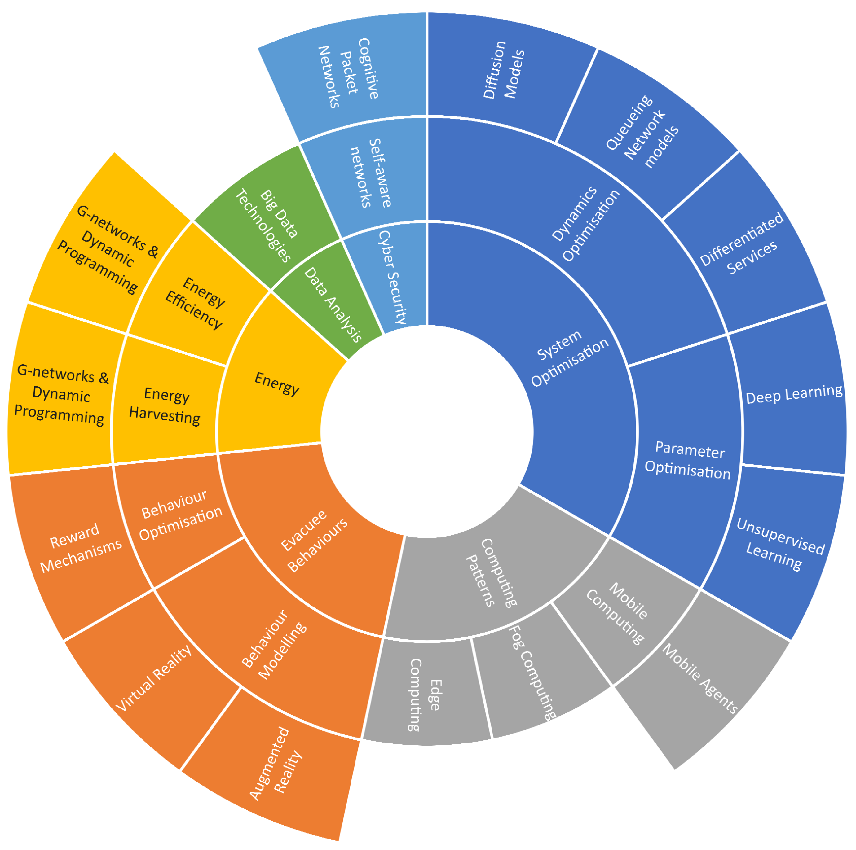
4. Conclusions and Challenges

In this paper, we have provided a systemic review of the evacuation wayfinding research. In the first section, we reviewed the history and evolution of the emergency management research field and traced its transformation from a reactive manner to a proactive manner. We also explored the impact of the development of computer technologies, which has shaped the current research. In the following sections, we reviewed the evacuation wayfinding from both the system design aspect and algorithm engineering aspect.
In the system review part, the systems were classified into human experience-driven systems, static WSN-based systems, mixed WSN-based systems, cloud-based systems with WSN and cloud-based systems with mobile phones.
In the algorithm review part, the algorithms were divided into off-line wayfinding algorithms and on-line wayfinding algorithms. The off-line wayfinding algorithms were further divided into cellular automata model-based algorithms, social force model-based algorithms, fluid-dynamics model-based algorithms, lattice gas model-based algorithms, game theoretic model-based algorithms, computer agent-based algorithms and animal agent-based algorithms. On the other hand, on-line evacuation wayfinding algorithms were classified into network flow-based algorithms, geometric algorithms, queueing model-based algorithms, potential-maintenance algorithms, biologically-inspired algorithms, routing protocol-based algorithms and prediction-based algorithms. In the next section, we discussed the emerging challenges and opportunities under the background of the fast development and prosperity of new technologies such as smart cities, artificial intelligence, virtual reality, big data, cyber-security and energy efficiency and harvesting.

Emerging Challenges and Opportunities

After decades of study and exploration, evacuation wayfinding has become a mature research field. However, due to its open and inclusive nature, new technologies always tend to influence, change or even revolutionise this research area. In this section, we discuss open issues and provide possible directions for future work. We also visualise these research directions by using a sunburst chart as shown in Figure 2.
Although the fire alarm system has become a norm for modern buildings, more complicated emergency management systems mostly remain in prototype form and are only verified in simulations or specific test fields. The rising concept of the“smart city” has provided a golden opportunity for evacuation wayfinding systems to be integrated into the smart city “ecosystem” and take advantage of this tide to achieve leapfrogging. The potential research directions are three-fold. First, with the recent increase of man-made disasters, physical attacks are highly likely to be accompanied with cyber attacks. Hence, it is of critical importance to develop self-aware networks to self-defend and maintain communications during an evacuation process. Our suggested framework is CPN, which is naturally efficient at defending various forms of malicious attacks such as denial of service and virus attacks [161,162], together with appropriate detection and mitigation mechanisms [163,164]. This is because, unlike the IP protocol, smart packets in the CPN carry the “full path” from the source node to the destination node. Hence, CPN can defend against denial of service attacks by adaptively dropping attacking packets upstream from the node being attacked via backtracking the full path of attacking flows. Second, due to the energy-hungry communication and computation processes inside evacuation wayfinding systems, as well as the fact that wireless sensors are difficult to replenish, energy-efficient and energy-harvesting algorithms, such as dynamic programming and G-network models [35,165,166], can be applied to future emergency management systems to improve the performance and efficiency of these systems. Third, the massive deployment of sensors with the prosperity of the Internet of Things (IoT) and smart city technologies improves the efficient collection of individual data on a vast scale. This suggests a crucial new opportunity to use big data technologies to analyse, model and refine the personal preferences, human collective choices and behaviours and general rules with respect to the routinely collected data and use them as guidance for the future emergency management algorithm and system design.
The emergence of heuristic-based algorithms has offered near-optimal solutions for evacuation wayfinding in a computationally time-efficient manner at the trade-off of optimality and completeness. However, the setting of key parameters in heuristics could play a vital role in system performance, and the perfect parameter settings for one evacuation scenario may not suit others. Hence, currently, significant parameters involved in heuristics are mostly pre-configured in a supervised-learning fashion rather than using an unsupervised learning paradigm and therefore may not adapt to uncertain or fast-changing environments, and may even need to be calibrated manually in different scenarios. This requires much further research.
Taking WSN-based algorithms for example, the work in [154] showed that these parameters could contribute significantly to the efficiency of route discovery and information collection. For instance, if the time-to-live of packets is too large, the system will be overburdened with packets that are in effect lost. On the other hand, if the life-time constraint is too small, some distant exits may not be discovered. Likewise, the improper packet rate could induce unnecessary energy consumption [34] when appropriate paths have been discovered and the network situation stays unchanged. Hence, future research can be directed toward optimising the setting of parameters from a systemic point of view by utilising proper queueing network models or diffusion models [116]. Differentiated service (DiffServ) mechanisms could be also developed to optimise the packet behaviours and satisfy the QoS requirements of different categories of cognitive packets that are associated with diverse classes of evacuees. Furthermore, parameter optimisation algorithms or even parameter-free algorithms can be developed by gaining experience from iterations of various simulated scenarios with the aid of machine learning as in other applications [167], including deep learning [168].
Compared with emergency drills, computer simulations are commonly utilised to investigate the effectiveness of evacuation wayfinding algorithms due to their time efficiency, repeatability and cost efficiency. However, many human behaviours during emergency evacuations have been ignored in the simulations. Hence, future research can also be directed to develop various human-computer interfaces for simulators to generate an artificial hazard environment with virtual reality and augmented reality technologies [7]. By evacuating volunteers from the artificial hazard environment, their emergent behaviours can be collected and empirical collective behaviour models of human beings can be developed from the actual crowd measurements. However, this will require extensive validation and further studies.
One trend in emergency management is to develop artificial intelligence-aided algorithms to improve path-finding and resource allocation during standard or emergent evacuations. However, as a typical category of cyber-physical systems, the intelligence of evacuees, as well as possible pro-social behaviours such as helpfulness and a sense of duty have been excluded in the previous algorithms. As a result, the robustness of these algorithms cannot be ensured due to the high likelihood that evacuees do not follow the instructions. Moreover, unnecessary efforts have been dedicated to the use of AI, while in fact, many tasks can be easily accomplished by evacuees in the system via using human intelligence.
For instance, the identification of a fire source location could take significant effort when using AI-based algorithms, which involves the installation of cameras and the use of computer vision-related technologies. However, it would take no time or cost for evacuees to identify a fire and report to authorities or the emergency response system by using smart phones. In attempting to incentivise evacuees to conduct cooperative behaviours and avoid destructive behaviours, one future research direction could be dedicated to the investigation of reward mechanisms to integrate the human intelligence of evacuees into the emergency response systems to improve the efficiency, adaptiveness and robustness of these systems. Thus, the link between human psychology and emergency response will require much further work in the coming years.
On the other hand, since most of the previous multi-robot rescue systems only followed simple coordination rules and lacked explicit teamwork models or goals [169], multi-agent technologies can also be utilised to model and develop various cooperative strategies, with the aid of queueing network models such as G-networks [170,171] or genetic algorithms [138,172].
The rapid development of cloud technologies has facilitated the advancement of cloud-enabled evacuation wayfinding systems that consist of front-end portable devices and back-end cloud severs. Future research can be directed to further improve the flexibility of the kind of system by leveraging the mobile agent technology, because current cloud-based emergency response systems, which are based on the client-sever paradigm, demand pre-installed services in participating devices [173]. Moreover, since mobile agents can migrate seamlessly through multiple clouds and different portable devices, a mobile agent-based emergency response system has the potential to reduce communication costs and ease network congestion in large-scale emergency evacuations by dynamically optimising the locations of mobile agents. Moreover, we believe that future evacuation wayfinding systems should not only make use of the computing power of portable devices and the cloud, but also other individual devices in the vicinity to offer services with the aid of edge computing and fog computing.

Funding

This research has been partially supported by the European Union’s Horizon 2020 research and innovation programme under grant agreement No 780139 for the SerIoT Project. The information and views set out in this paper are those of the authors and do not necessarily reflect the official opinion of the European Union. Neither the European Union institutions and bodies, nor any person or organization acting on their behalf, may be held responsible for the use which may be made of the information contained herein.

Conflicts of Interest

The authors declare no conflict of interest.

References

  1. Gelenbe, E.; Koçak, T. Area-based results for mine detection. IEEE Trans. Geosci. Remote Sens. 2000, 38, 12–24. [Google Scholar] [CrossRef]
  2. Gelenbe, E.; Wu, F.J. Future research on cyber-physical emergency management systems. Future Internet 2013, 5, 336–354. [Google Scholar] [CrossRef]
  3. McDonald, R.T.; Kitts, C.A.; Neumann, M. Experimental Implementation and Verification of Scalar Field Ridge, Trench, and Saddle Point Maneuvers Using Multirobot Adaptive Navigation. IEEE Access 2019, 7, 62950–62961. [Google Scholar] [CrossRef]
  4. Dimakis, N.; Filippoupolitis, A.; Gelenbe, E. Distributed Building Evacuation Simulator for Smart Emergency Management. Comput. J. 2010, 53, 1384–1400. [Google Scholar] [CrossRef] [Green Version]
  5. Haddow, G.; Bullock, J.; Coppola, D.P. Introduction to Emergency Management; Butterworth-Heinemann: Oxford, UK, 2017. [Google Scholar]
  6. Gelenbe, E.; Cao, Y. Autonomous search for mines. Eur. J. Oper. Res. 1998, 108, 319–333. [Google Scholar] [CrossRef]
  7. Gelenbe, E.; Hussain, K.; Kaptan, V. Simulating autonomous agents in augmented reality. J. Syst. Softw. 2005, 74, 255–268. [Google Scholar] [CrossRef] [Green Version]
  8. Belardo, S.; Karwan, K.R.; Wallace, W. An investigation of system design considerations for emergency management decision support. IEEE Trans. Syst. Man Cybern. 1984, 14, 795–804. [Google Scholar] [CrossRef]
  9. Chalmet, L.; Francis, R.; Saunders, P. Network models for building evacuation. Fire Technol. 1982, 18, 90–113. [Google Scholar] [CrossRef]
  10. Hughes, T. Graph processing by which to evacuate a mine. In Proceedings of the 1990 Symposium on Applied Computing, Fayetteville, AR, USA, 5–6 April 1990; pp. 137–141. [Google Scholar]
  11. Southworth, F.; Chin, S.M.; Cheng, P. A telemetric monitoring and analysis system for use during large scale population evacuations. In Proceedings of the Second International Conference on Road Traffic Monitoring, London, UK, 7–9 February 1989; pp. 99–103. [Google Scholar]
  12. Griffith, D. The critical problems of hurricane evacuation and alternative solutions. In Proceedings of the OCEANS 82, Washington, DC, USA, 20–22 September 1982; pp. 990–994. [Google Scholar]
  13. Zorpette, G. Evacuation planning for Lilco’s Shoreham plant: Lack of an approved emergency evacuation strategy may prevent full operation of a $5 billion nuclear power plant on long Island’s north shore. IEEE Spectr. 1987, 24, 22–24. [Google Scholar] [CrossRef]
  14. Serpa, D.P.; Walker, D.M.; Jenckes, T.A. Emergency Monitoring, Assessment and Response System for Diablo Canyon Nuclear Power Plant. IEEE Trans. Nucl. Sci. 1981, 28, 236–241. [Google Scholar] [CrossRef]
  15. Gelenbe, E. A diffusion model for packet travel time in a random multi-hop medium. ACM Trans. Sens. Networks (Tosn) 2007, 3, 10. [Google Scholar] [CrossRef]
  16. Filippoupolitis, A.; Gelenbe, E. A distributed decision support system for Building Evacuation. In Proceedings of the 2nd Conference on Human System Interactions, Catania, Italy, 21–23 May 2009; pp. 323–330. [Google Scholar]
  17. Gelenbe, E.; Sevcik, K. Analysis of update synchronization for multiple copy data bases. IEEE Trans. Comput. 1979, 100, 737–747. [Google Scholar] [CrossRef]
  18. Tseng, Y.C.; Pan, M.S.; Tsai, Y.Y. Wireless sensor networks for emergency navigation. Computer 2006, 39, 55–62. [Google Scholar] [CrossRef]
  19. Park, V.D.; Corson, M.S. A highly adaptive distributed routing algorithm for mobile wireless networks. In Proceedings of the Sixteenth Annual Joint Conference of the IEEE Computer and Communications Societies. Driving the Information Revolution, Kobe, Japan, 7–12 April 1997; Volume 3, pp. 1405–1413. [Google Scholar]
  20. Li, Q.; De Rosa, M.; Rus, D. Distributed algorithms for guiding navigation across a sensor network. In Proceedings of the 9th Annual International Conference on Mobile Computing and Networking, San Diego, CA, USA, 14–19 September 2003; pp. 313–325. [Google Scholar]
  21. Koditschek, D.E. Robot planning and control via potential functions. Robot. Rev. 1989, 1, 349–367. [Google Scholar]
  22. Gorbil, G.; Gelenbe, E. Opportunistic communications for emergency support systems. Procedia Comput. Sci. 2011, 5, 39–47. [Google Scholar] [CrossRef]
  23. Gelenbe, E.; Gorbil, G. Wireless networks in emergency management. In Proceedings of the First ACM International Workshop on Practical Issues and Applications in Next Generation Wireless Networks, Istanbul, Turkey, 26 August 2012; pp. 1–6. [Google Scholar]
  24. Gorbil, G.; Gelenbe, E. Resilient emergency evacuation using opportunistic communications. In Computer and Information Sciences III; Springer: Berlin/Heidelberg, Germany, 2013; pp. 249–257. [Google Scholar]
  25. Pelusi, L.; Passarella, A.; Conti, M. Opportunistic networking: data forwarding in disconnected mobile ad hoc networks. IEEE Commun. Mag. 2006, 44, 134–141. [Google Scholar] [CrossRef]
  26. Filippoupolitis, A.; Gorbil, G.; Gelenbe, E. Autonomous navigation systems for emergency management in buildings. In Proceedings of the 2011 IEEE Globecom Workshops (GC Wkshps), Houston, TX, USA, 5–9 December 2011; pp. 1056–1061. [Google Scholar]
  27. Zubair, S.; bnt Fisal, N.; Yerima, S.; Salihu, B.; Salihu, Y. CoWiSMoN: A framework for cognitive wireless sensor mobile network system for emergency rescue management. In Proceedings of the 2011 3rd IEEE International Conference Adaptive Science and Technology (ICAST), Abuja, Nigeria, 24–26 November 2011; pp. 237–241. [Google Scholar]
  28. Inoue, Y.; Sashima, A.; Ikeda, T.; Kurumatani, K. Indoor Emergency Evacuation Service on Autonomous Navigation System using Mobile Phone. In Proceedings of the Second International Symposium Universal Communication, Osaka, Japan, 15–16 December 2008; pp. 79–85. [Google Scholar]
  29. Tseng, Y.C.; Wang, Y.C.; Cheng, K.Y.; Hsieh, Y.Y. iMouse: An Integrated Mobile Surveillance and Wireless Sensor System. Computer 2007, 40, 60–66. [Google Scholar] [CrossRef]
  30. Dong, M.; Li, H.; Ota, K.; Yang, L.; Zhu, H. Multicloud-Based Evacuation Services for Emergency Management. IEEE Cloud Comput. 2014, 1, 50–59. [Google Scholar] [CrossRef]
  31. Chu, L.; Wu, S.J. An Integrated Building Fire Evacuation System with RFID and Cloud Computing. In Proceedings of the 2011 Seventh International Conference on Intelligent Information Hiding and Multimedia Signal Processing (IIH-MSP), Dalian, China, 14–16 October 2011; pp. 17–20. [Google Scholar]
  32. Qiu, M.; Ming, Z.; Wang, J.; Yang, L.T.; Xiang, Y. Enabling Cloud Computing in Emergency Management Systems. IEEE Cloud Comput. 2014, 1, 60–67. [Google Scholar] [CrossRef]
  33. Gelenbe, E.; Bi, H. Emergency Navigation without an Infrastructure. Sensors 2014, 14, 15142–15162. [Google Scholar] [CrossRef] [Green Version]
  34. Gelenbe, E.; Mahmoodi, T. Energy-aware routing in the cognitive packet network. Energy 2011, 68, 7–12. [Google Scholar]
  35. Gelenbe, E. Energy packet networks: adaptive energy management for the cloud. In Proceedings of the 2nd International Workshop on Cloud Computing Platforms, Bern, Switzerland, 10–13 April 2012; p. 1. [Google Scholar]
  36. Helbing, D.; Farkas, I.; Vicsek, T. Simulating dynamical features of escape panic. Nature 2000, 407, 487–490. [Google Scholar] [CrossRef] [PubMed] [Green Version]
  37. Yang, L.; Zhao, D.; Li, J.; Fang, T. Simulation of the kin behavior in building occupant evacuation based on cellular automaton. Build. Environ. 2005, 40, 411–415. [Google Scholar] [CrossRef]
  38. Gwynne, S.; Galea, E.; Owen, M.; Lawrence, P.J.; Filippidis, L. ; others. A review of the methodologies used in evacuation modelling. Fire Mater. 1999, 23, 383–388. [Google Scholar] [CrossRef]
  39. Zheng, X.; Zhong, T.; Liu, M. Modeling crowd evacuation of a building based on seven methodological approaches. Build. Environ. 2009, 44, 437–445. [Google Scholar] [CrossRef]
  40. Wolfram, S. Statistical mechanics of cellular automata. Rev. Mod. Phys. 1983, 55, 601. [Google Scholar] [CrossRef]
  41. Bandini, S.; Manzoni, S.; Vizzari, G. Situated Cellular Agents: A model to simulate crowding dynamics. IEICE Trans. Inf. Syst. Spec. Issue Cell. Autom. 2004, 87, 669–676. [Google Scholar]
  42. Yu, Y.; Song, W. Cellular automaton simulation of pedestrian counter flow considering the surrounding environment. Phys. Rev. E 2007, 75, 046112. [Google Scholar] [CrossRef]
  43. Spartalis, E.; Georgoudas, I.G.; Sirakoulis, G.C. CA Crowd Modeling for a Retirement House Evacuation with Guidance. In Cellular Automata; Springer: Berlin/Heidelberg, Germany, 2014; pp. 481–491. [Google Scholar]
  44. Müller, F.; Wohak, O.; Schadschneider, A. Study of Influence of Groups on Evacuation Dynamics Using a Cellular Automaton Model. Transp. Res. Procedia 2014, 2, 168–176. [Google Scholar] [CrossRef] [Green Version]
  45. Helbing, D.; Molnar, P. Social force model for pedestrian dynamics. Phys. Rev. E 1995, 51, 4282. [Google Scholar] [CrossRef]
  46. Parisi, D.; Dorso, C. Microscopic dynamics of pedestrian evacuation. Phys. Stat. Mech. Its Appl. 2005, 354, 606–618. [Google Scholar] [CrossRef]
  47. Seyfried, A.; Steffen, B.; Lippert, T. Basics of modelling the pedestrian flow. Phys. Stat. Mech. Its Appl. 2006, 368, 232–238. [Google Scholar] [CrossRef] [Green Version]
  48. Henderson, L. The statistics of crowd fluids. Nature 1971, 229, 381–383. [Google Scholar] [CrossRef] [PubMed]
  49. Helbing, D.; Farkas, I.J.; Molnar, P.; Vicsek, T. Simulation of pedestrian crowds in normal and evacuation situations. Pedestr. Evacuation Dyn. 2002, 21, 21–58. [Google Scholar]
  50. Fredkin, E.; Toffoli, T. Conservative Logic; Springer: Berlin/Heidelberg, Germany, 2002. [Google Scholar]
  51. Tajima, Y.; Takimoto, K.; Nagatani, T. Scaling of pedestrian channel flow with a bottleneck. Phys. Stat. Mech. Its Appl. 2001, 294, 257–268. [Google Scholar] [CrossRef]
  52. Takimoto, K.; Nagatani, T. Spatio-temporal distribution of escape time in evacuation process. Phys. Stat. Mech. Its Appl. 2003, 320, 611–621. [Google Scholar] [CrossRef]
  53. Hoogendoorn, S.; HL Bovy, P. Simulation of pedestrian flows by optimal control and differential games. Optim. Control. Appl. Methods 2003, 24, 153–172. [Google Scholar] [CrossRef]
  54. Lo, S.M.; Huang, H.C.; Wang, P.; Yuen, K. A game theory based exit selection model for evacuation. Fire Saf. J. 2006, 41, 364–369. [Google Scholar] [CrossRef]
  55. Ehtamo, H.; Heliövaara, S.; Hostikka, S.; Korhonen, T. Modeling evacuees’ exit selection with best response dynamics. In Pedestrian and Evacuation Dynamics 2008; Springer: Berlin/Heidelberg, Germany, 2010; pp. 309–319. [Google Scholar]
  56. Zheng, X.; Cheng, Y. Modeling cooperative and competitive behaviors in emergency evacuation: A game-theoretical approach. Comput. Math. Appl. 2011, 62, 4627–4634. [Google Scholar] [CrossRef] [Green Version]
  57. Bonabeau, E. Agent-based modeling: Methods and techniques for simulating human systems. Proc. Natl. Acad. Sci. USA 2002, 99, 7280–7287. [Google Scholar] [CrossRef] [Green Version]
  58. Zarboutis, N.; Marmaras, N. Searching efficient plans for emergency rescue through simulation: the case of a metro fire. Cogn. Technol. Work 2004, 6, 117–126. [Google Scholar] [CrossRef]
  59. Goldstone, R.L.; Janssen, M.A. Computational models of collective behavior. Trends Cogn. Sci. 2005, 9, 424–430. [Google Scholar] [CrossRef] [PubMed]
  60. Pan, X.; Han, C.S.; Dauber, K.; Law, K.H. A multi-agent based framework for the simulation of human and social behaviors during emergency evacuations. AI Soc. 2007, 22, 113–132. [Google Scholar] [CrossRef]
  61. Saloma, C.; Perez, G.J.; Tapang, G.; Lim, M.; Palmes-Saloma, C. Self-organized queuing and scale-free behavior in real escape panic. Proc. Natl. Acad. Sci. USA 2003, 100, 11947–11952. [Google Scholar] [CrossRef] [PubMed] [Green Version]
  62. Altshuler, E.; Ramos, O.; Núñez, Y.; Fernández, J.; Batista-Leyva, A.; Noda, C. Symmetry breaking in escaping ants. Am. Nat. 2005, 166, 643–649. [Google Scholar] [CrossRef]
  63. Pelechano, N.; Malkawi, A. Evacuation simulation models: Challenges in modeling high rise building evacuation with cellular automata approaches. Autom. Constr. 2008, 17, 377–385. [Google Scholar] [CrossRef]
  64. Perez, G.J.; Tapang, G.; Lim, M.; Saloma, C. Streaming, disruptive interference and power-law behavior in the exit dynamics of confined pedestrians. Phys. Stat. Mech. Its Appl. 2002, 312, 609–618. [Google Scholar] [CrossRef]
  65. Burstedde, C.; Klauck, K.; Schadschneider, A.; Zittartz, J. Simulation of pedestrian dynamics using a two-dimensional cellular automaton. Physica A 2004, 295, 507–525. [Google Scholar] [CrossRef]
  66. Zheng, M.; Kashimori, Y.; Kambara, T. A model describing collective behaviors of pedestrians with various personalities in danger situations. In Proceedings of the 9th International Conference on Neural Information Processing, Singapore, 18–22 November 2002; Volume 4, pp. 2083–2087. [Google Scholar]
  67. Hecht-Nielsen, R. Applications of counter-propagation networks. Neural Netw. 1988, 1, 131–139. [Google Scholar] [CrossRef]
  68. Hughes, R.L. A continuum theory for the flow of pedestrians. Transp. Res. Part Methodol. 2002, 36, 507–535. [Google Scholar] [CrossRef]
  69. Colombo, R.M.; Rosini, M.D. Pedestrian flows and non-classical shocks. Math. Methods Appl. Sci. 2005, 28, 1553–1567. [Google Scholar] [CrossRef]
  70. Lighthill, M.J.; Whitham, G.B. On kinematic waves. II. A theory of traffic flow on long crowded roads. Proc. R. Soc. Lond. A 1955, 229, 317–345. [Google Scholar]
  71. Liu, T.P. The Riemann problem for general systems of conservation laws. J. Differ. Equ. 1975, 18, 218–234. [Google Scholar] [CrossRef] [Green Version]
  72. Thouless, D.J. The Quantum Mechanics of Many-Body Systems; Dover Publications: Mineola, NY, USA, 2013. [Google Scholar]
  73. Kirchner, A.; Klüpfel, H.; Nishinari, K.; Schadschneider, A.; Schreckenberg, M. Simulation of competitive egress behavior: comparison with aircraft evacuation data. Phys. Stat. Mech. Its Appl. 2003, 324, 689–697. [Google Scholar] [CrossRef]
  74. Fudenberg, D.; Tirole, J. Game Theory; MIT Press: Cambridge, MA, USA, 1991; Volume 393. [Google Scholar]
  75. Nash, J. Non-cooperative games. Ann. Math. 1951, 54, 286–295. [Google Scholar] [CrossRef]
  76. Nakamura, T.; Asada, M. Motion sketch: Acquisition of visual motion guided behaviors. In Proceedings of the 14th International Joint Conference Artificial Intelligence, Montreal, QC, Canada, 20–25 August 1995; Volume 1, pp. 126–132. [Google Scholar]
  77. March, J.G. Primer on Decision Making: How Decisions Happen; Simon and Schuster: New York, NY, USA, 1994. [Google Scholar]
  78. Kuligowski, E.D.; Peacock, R.D.; Hoskins, B. A Review of Building Evacuation Models; US Department of Commerce, National Institute of Standards and Technology: Gaithersburg, MD, USA, 2005. [Google Scholar]
  79. Gelenbe, E.; Wu, F.J. Large scale simulation for human evacuation and rescue. Comput. Math. Appl. 2012, 64, 3869–3880. [Google Scholar] [CrossRef] [Green Version]
  80. Francis, R. A Negative Exponential Solution to an Evacuation Problem; National Bureau of Standards, Center for Fire Research: Springfield, VA, USA, 1984.
  81. Kisko, T.M.; Francis, R.L. EVACNET+: A computer program to determine optimal building evacuation plans. Fire Saf. J. 1985, 9, 211–220. [Google Scholar] [CrossRef]
  82. Lu, Q.; Huang, Y.; Shekhar, S. Evacuation planning: a capacity constrained routing approach. In Intelligence and Security Informatics; Springer: Berlin/Heidelberg, Germany, 2003; pp. 111–125. [Google Scholar]
  83. Lu, Q.; George, B.; Shekhar, S. Capacity constrained routing algorithms for evacuation planning: A summary of results. In Advances in Spatial and Temporal Databases; Springer: Berlin/Heidelberg, Germany, 2005; pp. 291–307. [Google Scholar]
  84. Chen, P.Y.; Chen, W.T.; Shen, Y.T. A distributed area-based guiding navigation protocol for wireless sensor networks. In Proceedings of the 14th IEEE International Conference on Parallel and Distributed Systems, Melbourne, Australia, 8–10 December 2008; pp. 647–654. [Google Scholar]
  85. Wang, J.; Li, Z.; Li, M.; Liu, Y.; Yang, Z. Sensor network navigation without locations. IEEE Trans. Parallel Distrib. Syst. 2013, 24, 1436–1446. [Google Scholar] [CrossRef]
  86. MacGregor Smith, J. State-dependent queueing models in emergency evacuation networks. Transp. Res. Part B Methodol. 1991, 25, 373–389. [Google Scholar] [CrossRef]
  87. Cruz, F.R.; Smith, J.M.; Queiroz, D. Service and capacity allocation in M/G/c/c state-dependent queueing networks. Comput. Oper. Res. 2005, 32, 1545–1563. [Google Scholar] [CrossRef]
  88. Stepanov, A.; Smith, J.M. Multi-objective evacuation routing in transportation networks. Eur. J. Oper. Res. 2009, 198, 435–446. [Google Scholar] [CrossRef]
  89. Lino, P.; Maione, G.; Maione, B. Modeling and simulation of crowd egress dynamics in a discrete event environment. In Proceedings of the 2009 IEEE Control Applications (CCA) & Intelligent Control, Intelligent Control, Petersburg, Russia, 8–10 July 2009; pp. 843–848. [Google Scholar]
  90. Desmet, A.; Gelenbe, E. Graph and analytical models for emergency evacuation. Future Internet 2013, 5, 46–55. [Google Scholar] [CrossRef]
  91. Bi, H. Evacuee Flow Optimisation Using G-Network with Multiple Classes of Positive Customers. In Proceedings of the 2016 IEEE 24th International Symposium on Modeling, Analysis and Simulation of Computer and Telecommunication Systems (MASCOTS), London, UK, 19–21 September 2016; pp. 135–143. [Google Scholar]
  92. Bi, H.; Abdelrahman, O.H. Energy-Aware Navigation in Large-Scale Evacuation Using G-networks. Probab. Eng. Inform. Sci. 2018, 32, 340–352. [Google Scholar] [CrossRef]
  93. Chen, W.T.; Chen, P.Y.; Wu, C.H.; Huang, C.F. A load-balanced guiding navigation protocol in wireless sensor networks. In Proceedings of the IEEE Globecom 2008 Global Telecommunications Conference, New Orleans, LA, USA, 30 November–4 December 2008; pp. 1–6. [Google Scholar]
  94. Gelenbe, E.; Timotheou, S. Random neural networks with synchronized interactions. Neural Comput. 2008, 20, 2308–2324. [Google Scholar] [CrossRef] [PubMed]
  95. Jankowska, A.; Schut, M.; Ferreira-Schut, N. A wireless actuator-sensor neural network for evacuation routing. In Proceedings of the Third International Conference on Sensor Technologies and Applications, Athens/Glyfada, Greece, 18–23 June 2009; pp. 139–144. [Google Scholar]
  96. Li, Q.; Fang, Z.; Li, Q.; Zong, X. Multiobjective evacuation route assignment model based on genetic algorithm. In Proceedings of the 2010 18th International Conference on Geoinformatics, Beijing, China, 18–20 June 2010; pp. 1–5. [Google Scholar]
  97. Filippoupolitis, A. Emergency Simulation and Decision Support Algorithms. Ph.D. Thesis, Imperial College London (University of London), London, UK, 2010. [Google Scholar]
  98. Bi, H.; Desmet, A.; Gelenbe, E. Routing Emergency Evacuees with Cognitive Packet Networks. In Proceedings of the 28th International Symposium on Computer and Information Sciences (ISCIS’13), Paris, France, 28–29 October 2013; Springer: London, UK, 2013. [Google Scholar]
  99. Bi, H.; Gelenbe, E. Routing diverse evacuees with Cognitive Packets. In Proceedings of the 2014 IEEE International Conference on Pervasive Computing and Communications Workshops (PERCOM Workshops), Budapest, Hungary, 24–28 March 2014; pp. 291–296. [Google Scholar]
  100. Hasofer, A.; Odigie, D. Stochastic modelling for occupant safety in a building fire. Fire Saf. J. 2001, 36, 269–289. [Google Scholar] [CrossRef]
  101. Barnes, M.; Leather, H.; Arvind, D. Emergency evacuation using wireless sensor networks. In Proceedings of the 32nd IEEE Conference on Local Computer Networks, Dublin, Ireland, 15–18 October 2007; pp. 851–857. [Google Scholar]
  102. Han, L.; Potter, S.; Beckett, G.; Pringle, G.; Welch, S.; Koo, S.H.; Wickler, G.; Usmani, A.; Torero, J.L.; Tate, A. FireGrid: an e-infrastructure for next-generation emergency response support. J. Parallel Distrib. Comput. 2010, 70, 1128–1141. [Google Scholar] [CrossRef]
  103. Radianti, J.; Granmo, O.C.; Sarshar, P.; Goodwin, M.; Dugdale, J.; Gonzalez, J.J. A spatio-temporal probabilistic model of hazard-and crowd dynamics for evacuation planning in disasters. Appl. Intell. 2015, 42, 3–23. [Google Scholar] [CrossRef]
  104. Bi, H.; Gelenbe, E. Cloud enabled emergency navigation using faster-than-real-time simulation. In Proceedings of the 2015 IEEE International Conference on Pervasive Computing and Communication Workshops (PerCom Workshops), St. Louis, MO, USA, 23–27 March 2015; pp. 475–480. [Google Scholar]
  105. Ford, D.; Fulkerson, D.R. Flows in Networks; Princeton University Press: Princeton, NJ, USA, 2010. [Google Scholar]
  106. Ahuja, R.K.; Magnanti, T.L.; Orlin, J.B. Network Flows; Alfred P. Sloan School of Management, Massachusetts Institute of Technology: Cambridge, MA, USA, 1988. [Google Scholar]
  107. Graves, G.W.; Brown, G.G.; Bradley, G.H. Design and Implementation of Large-Scale Primal Transshipment Algorithms. Manag. Sci. 1977, 24, 1–34. [Google Scholar]
  108. Hoppe, B.; Tardos, É. Polynomial time algorithms for some evacuation problems. In Proceedings of the Fifth Annual ACM-SIAM Symposium on Discrete Algorithms, Society for Industrial and Applied Mathematics, Arlington, VA, USA, 23–25 January 1994; pp. 433–441. [Google Scholar]
  109. Hoppe, B.; Tardos, É. The quickest transshipment problem. Math. Oper. Res. 2000, 25, 36–62. [Google Scholar] [CrossRef]
  110. Megiddo, N. Optimal flows in networks with multiple sources and sinks. Math. Program. 1974, 7, 97–107. [Google Scholar] [CrossRef]
  111. Minieka, E. Maximal, lexicographic, and dynamic network flows. Oper. Res. 1973, 21, 517–527. [Google Scholar] [CrossRef]
  112. Dijkstra, E.W. A note on two problems in connexion with graphs. Numer. Math. 1959, 1, 269–271. [Google Scholar] [CrossRef] [Green Version]
  113. Li, X.Y.; Calinescu, G.; Wan, P.J. Distributed construction of a planar spanner and routing for ad hoc wireless networks. In Proceedings of the Twenty-First Annual Joint Conference of the IEEE Computer and Communications Societies, New York, NY, USA, 23–27 June 2002; Volume 3, pp. 1268–1277. [Google Scholar]
  114. Li, X.Y.; Calinescu, G.; Wan, P.J.; Wang, Y. Localized delaunay triangulation with application in ad hoc wireless networks. IEEE Trans. Parallel Distrib. Syst. 2003, 14, 1035–1047. [Google Scholar]
  115. Bruck, J.; Gao, J.; Jiang, A. MAP: Medial axis based geometric routing in sensor networks. Wirel. Netw. 2007, 13, 835–853. [Google Scholar] [CrossRef]
  116. Gelenbe, E.; Pujolle, G. Introduction aux réSeaux de Files d’Attente; Eyrolles: Paris, France, 1982. [Google Scholar]
  117. Gelenbe, E.; Muntz, R.R. Probabilistic models of computer systems, Part I (Exact Results). Acta Inform. 1976, 7, 35–60. [Google Scholar] [CrossRef]
  118. Gelenbe, E. A unified approach to a class of page replacement algorithms. IEEE Trans. Comput. 1973, 22, 611–618. [Google Scholar] [CrossRef]
  119. Fruin, J.J. Pedestrian Planning and Design; Metropolitan Association of Urban Designers and Environmental Planners, Inc. In Pedestrian Planning and Design; Metropolitan Association of Urban Designers and Environmental Planners, Inc.: New York, NY, USA, 1971. [Google Scholar]
  120. Tregenza, P. The Design of Interior Circulation; Van Nostrand Reinhold: New York, NY, USA, 1976. [Google Scholar]
  121. Francis, R.L.; Chalmet, L.G. Network Models for Building Evacuation: A Prototype Primer; Department of Industrial and Systems Engineering, University of Florida: Gainesville, FL, USA, 1980. [Google Scholar]
  122. Yuhaski, S.J., Jr.; Smith, J.M. Modeling circulation systems in buildings using state dependent queueing models. Queueing Syst. 1989, 4, 319–338. [Google Scholar] [CrossRef]
  123. Cheah, J.Y.; Smith, J.M. Generalized M/G/c/c state dependent queueing models and pedestrian traffic flows. Queueing Syst. 1994, 15, 365–386. [Google Scholar] [CrossRef]
  124. Kerbachea, L.; Smith, J.M. The generalized expansion method for open finite queueing networks. Eur. J. Oper. Res. 1987, 32, 448–461. [Google Scholar] [CrossRef]
  125. Kerbache, L.; Smith, J.M. Asymptotic behavior of the expansion method for open finite queueing networks. Comput. Oper. Res. 1988, 15, 157–169. [Google Scholar] [CrossRef]
  126. Smith, J.M.; Gershwin, S.B.; Papadopoulos, C.T. Performance Evaluation and Optimization of Production Lines; Baltzer Science Publishers: Amsterdam, The Netherlands, 2000; Volume 93. [Google Scholar]
  127. Lino, P.; Pizzileo, B.; Maione, G.; Maione, B. Tuning and Validation of a Discrete-Event Model of the Egress Dynamics from Buildings. IFAC Proc. Vol. 2011, 44, 8743–8748. [Google Scholar] [CrossRef] [Green Version]
  128. Wang, P.; Luh, P.B.; Chang, S.C.; Sun, J. Modeling and optimization of crowd guidance for building emergency evacuation. In Proceedings of the IEEE International Conference on Automation Science and Engineering, Washington, DC, USA, 23–26 August 2008; pp. 328–334. [Google Scholar]
  129. Watts, J.M. Computer models for evacuation analysis. Fire Saf. J. 1987, 12, 237–245. [Google Scholar] [CrossRef]
  130. Cruz, F.R.; Smith, J.M.; Medeiros, R. An M/G/C/C state-dependent network simulation model. Comput. Oper. Res. 2005, 32, 919–941. [Google Scholar] [CrossRef]
  131. Gelenbe, E.; Labed, A. G-networks with multiple classes of signals and positive customers. Eur. J. Oper. Res. 1998, 108, 293–305. [Google Scholar] [CrossRef]
  132. Gelenbe, E. G-networks with triggered customer movement. J. Appl. Probab. 1993, 30, 742–748. [Google Scholar] [CrossRef]
  133. Hill, J.; Szewczyk, R.; Woo, A.; Hollar, S.; Culler, D.; Pister, K. System architecture directions for networked sensors. ACM SIGOPS Oper. Syst. Rev. 2000, 34, 93–104. [Google Scholar] [CrossRef]
  134. Pan, M.S.; Tsai, C.H.; Tseng, Y.C. Emergency guiding and monitoring applications in indoor 3D environments by wireless sensor networks. Int. J. Sens. Netw. 2006, 1, 2–10. [Google Scholar] [CrossRef]
  135. Gelenbe, E.; Schmajuk, N.; Staddon, J.; Reif, J. Autonomous search by robots and animals: A survey. Robot. Auton. Syst. 1997, 22, 23–34. [Google Scholar] [CrossRef]
  136. Mitchell, T.M. Machine Learning; McGraw Hill: Burr Ridge, IL, USA, 1997; Volume 45. [Google Scholar]
  137. John, H. Adaptation in Natural and Artificial Systems; University of Michigan Press: Ann Arbor, MI, USA, 1992. [Google Scholar]
  138. Gelenbe, E.; Liu, P.; Laine, J. Genetic algorithms for route discovery. IEEE Trans. Syst. Man Cybern. Part B 2006, 36, 1247–1254. [Google Scholar] [CrossRef]
  139. Deb, K.; Agrawal, S.; Pratap, A.; Meyarivan, T. A fast elitist non-dominated sorting genetic algorithm for multi-objective optimization: NSGA-II. Lect. Notes Comput. Sci. 2000, 1917, 849–858. [Google Scholar]
  140. Eppstein, D. Finding the k shortest paths. SIAM J. Comput. 1998, 28, 652–673. [Google Scholar] [CrossRef]
  141. Saadatseresht, M.; Mansourian, A.; Taleai, M. Evacuation planning using multiobjective evolutionary optimization approach. Eur. J. Oper. Res. 2009, 198, 305–314. [Google Scholar] [CrossRef]
  142. Pan, X.; Han, C.S.; Law, K.H. A multi-agent based simulation framework for the study of human and social behavior in egress analysis. In Proceedings of the ASCE International Conference on Computing in Civil Engineering, Cancun, Mexico, 12–15 July 2005; Volume 92. [Google Scholar]
  143. Samadzadegan, F.; Yadegari, M. A biologically-inspired optimization algorithm for urban evacuation planning in disaster management. In Proceedings of the ACRS, Hanoi, Vietnam, 1–5 November 2010; Volume 1, pp. 573–578. [Google Scholar]
  144. Karaboga, D. An Idea Based on Honey Bee Swarm for Numerical Optimization; Technical Report-tr06; Erciyes University Press: Kayseri, Turkey, 2005. [Google Scholar]
  145. Gelenbe, E.; Lent, R.; Xu, Z. Towards networks with cognitive packets. In Performance and QoS of Next Generation Networking; Springer: London, UK, 2001; pp. 3–17. [Google Scholar]
  146. Gelenbe, E.; Lent, R.; Xu, Z. Design and performance of cognitive packet networks. Perform. Eval. 2001, 46, 155–176. [Google Scholar] [CrossRef]
  147. Gelenbe, E. Sensible decisions based on QoS. Comput. Manag. Sci. 2003, 1, 1–14. [Google Scholar] [CrossRef]
  148. Vahdat, A.; Becker, D. Epidemic Routing for Partially Connected ad Hoc Networks; Technical Report CS-200006; Duke University: Durham, NC, USA,, 2000. [Google Scholar]
  149. Gorbil, G.; Gelenbe, E. Resilience and security of opportunistic communications for emergency evacuation. In Proceedings of the 7th ACM Workshop on Performance Monitoring and Measurement of Heterogeneous Wireless and Wired Networks, Paris, France, 21–23 November 2012; pp. 115–124. [Google Scholar]
  150. Gelenbe, E. Réseaux neuronaux aléatoires stables. Comptes Rendus de l’Académie des Sciences. Série 2 1990, 310, 177–180. [Google Scholar]
  151. Gelenbe, E. Random neural networks with negative and positive signals and product form solution. Neural Comput. 1989, 1, 502–510. [Google Scholar] [CrossRef]
  152. Gelenbe, E.; Stafylopatis, A. Global behavior of homogeneous random neural systems. Appl. Math. Model. 1991, 15, 534–541. [Google Scholar] [CrossRef]
  153. Gelenbe, E. Learning in the recurrent random neural network. Neural Comput. 1993, 5, 154–164. [Google Scholar] [CrossRef]
  154. Desmet, A.; Gelenbe, E. A Parametric Study of CPN’s Convergence Process. In Information Sciences and Systems 2014; Springer: Cham, Switerland, 2014; pp. 13–20. [Google Scholar]
  155. Bi, H. Routing Diverse Evacuees with the Cognitive Packet Network Algorithm. Future Internet 2014, 6, 203. [Google Scholar] [CrossRef]
  156. Akinwande, O.; Bi, H.; Gelenbe, E. Managing Crowds in Hazards With Dynamic Grouping. IEEE Access 2015, 3, 1060–1070. [Google Scholar] [CrossRef] [Green Version]
  157. Olenick, S.M.; Carpenter, D.J. An updated international survey of computer models for fire and smoke. J. Fire Prot. Eng. 2003, 13, 87–110. [Google Scholar] [CrossRef]
  158. Koo, S.H.; Fraser-Mitchell, J.; Upadhyay, R.; Welch, S. Sensor-linked fire simulation using a Monte-Carlo approach. Fire Saf. Sci. 2008, 9, 1389–1400. [Google Scholar] [CrossRef] [Green Version]
  159. Murphy, K.P. Dynamic Bayesian Networks: Representation, Inference and Learning. Ph.D. Thesis, University of California, Berkeley, Berkeley, CA, USA, 2002. [Google Scholar]
  160. Wang, L.; Gelenbe, E. Adaptive dispatching of tasks in the cloud. IEEE Trans. Cloud Comput. 2018, 6, 33–45. [Google Scholar] [CrossRef]
  161. Gelenbe, E.; Loukas, G. A self-aware approach to denial of service defence. Comput. Netw. 2007, 51, 1299–1314. [Google Scholar] [CrossRef]
  162. Gelenbe, E. Dealing with software viruses: a biological paradigm. Inf. Secur. Tech. Rep. 2007, 12, 242–250. [Google Scholar] [CrossRef]
  163. Oke, G.; Loukas, G.; Gelenbe, E. Detecting denial of service attacks with bayesian classifiers and the random neural network. In Proceedings of the 2007 IEEE International Fuzzy Systems Conference, London, UK, 23–26 July 207; pp. 1–6.
  164. Brun, O.; Yin, Y.; Gelenbe, E.; Kadioglu, Y.M.; Augusto-Gonzalez, J.; Ramos, M. Deep Learning with Dense Random Neural Networks for Detecting Attacks against IoT-connected Home Environments. Procedia Comput. Sci. 2018, 134, 458–463. [Google Scholar] [CrossRef]
  165. Gelenbe, E. Adaptive management of energy packets. In Proceedings of the 2014 IEEE 38th International Computer Software and Applications Conference Workshops (COMPSACW), Vasteras, Sweden, 21–25 July 2014; pp. 1–6. [Google Scholar]
  166. Gelenbe, E. A sensor node with energy harvesting. ACM SIGMETRICS Perform. Eval. Rev. 2014, 42, 37–39. [Google Scholar] [CrossRef]
  167. Cramer, C.E.; Gelenbe, E. Video quality and traffic QoS in learning-based subsampled and receiver-interpolated video sequences. IEEE J. Sel. Areas Commun. 2000, 18, 150–167. [Google Scholar] [CrossRef] [Green Version]
  168. Gelenbe, E.; Yin, Y. Deep learning with random neural networks. In Proceedings of the 2016 International Joint Conference on Neural Networks (IJCNN), Vancouver, BC, Canada, 24–29 July 2016; pp. 1633–1638. [Google Scholar]
  169. Nourbakhsh, I.R.; Sycara, K.; Koes, M.; Yong, M.; Lewis, M.; Burion, S. Human-robot teaming for search and rescue. IEEE Pervasive Comput. 2005, 4, 72–79. [Google Scholar] [CrossRef]
  170. Gelenbe, E. The first decade of G-networks. Eur. J. Oper. Res. 2000, 126, 231–232. [Google Scholar] [CrossRef]
  171. Boxma, O.J.; Gelenbe, E. Two symmetric queues with alternating service and switching times. In Models of Computer System Performance, Proceedings of the 10th IFIP WG7. 3 International Symposium on Computer Performance Modelling, Measurement and Evaluation, Paris, France, 19–21 December 1984; North-Holland Publishing Company: Amsterdam, The Netherlands, 1985; pp. 409–431. [Google Scholar]
  172. Gelenbe, E. Steady-state solution of probabilistic gene regulatory networks. Phys. Rev. E 2007, 76, 031903. [Google Scholar] [CrossRef] [PubMed]
  173. Aversa, R.; Di Martino, B.; Rak, M.; Venticinque, S. Cloud agency: A mobile agent based cloud system. In Proceedings of the 2010 International Conference on Complex, Intelligent and Software Intensive Systems (CISIS), Krakow, Poland, 15–18 February 2010; pp. 132–137. [Google Scholar]
Figure 1. A tree diagram explaining the structure of the paper. We summarise the classical research and ideas of evacuation wayfinding from both system structure and algorithm design perspectives.
Electronics 08 00711 g001
Figure 2. A sunburst chart illustrating the potential research directions. The sunburst chart summarises the potential research directions from the system design, computing pattern, energy utilisation, behaviour modelling and optimisation, data analysis and cyber-security perspectives.
Electronics 08 00711 g002
Table 1. Evacuation wayfinding systems.
System TypePeriod
Human experience-driven systems1970s–1990s
Static WSN-based systems1995–present
Mixed WSN-based systems2006–present
WSN and cloud-based systems2007–present
Cloud-based systems and mobile phones2011–present

