Article

A VANET, Multi-Hop-Enabled, Dynamic Traffic Assignment for Road Networks

1
Department of Electrical and Computer Engineering, Florida International University (FIU), Miami, FL 33174, USA
2
Department of Computer and Electrical Engineering and Computer Science, Florida Atlantic University (FAU), Boca Raton, FL 33431, USA
*
Author to whom correspondence should be addressed.
Electronics 2025, 14(3), 559; https://doi.org/10.3390/electronics14030559
Submission received: 19 December 2024 / Revised: 13 January 2025 / Accepted: 22 January 2025 / Published: 30 January 2025
(This article belongs to the Special Issue Challenges and Opportunities in the Internet of Vehicles)

Abstract

:
Traffic congestion imposes burdens on society and individuals. In 2022, the average congestion cost per auto commuter in the USA was USD1259. New possibilities to increase traffic efficiency are now available as vehicles can interact using Vehicular Ad Hoc Network (VANET) systems, a subset of the Internet of Vehicles (IoV). The traffic assignment problem deals with road network traffic optimization. It is a complex and challenging problem. A few solutions incorporating VANET technology have been presented; most are centralized or depend on infrastructure. In previous work, we introduced Road-ACO, an ant colony optimization (ACO), single-hop, decentralized, infrastructure-less, VANET solution. In this paper, we propose a new multi-hop-enabled, decentralized, ant-colony-inspired algorithm for dynamic highway traffic assignment. The algorithm works for large road networks and requires no infrastructure. We develop Veins framework-based simulations to evaluate the algorithm’s performance. The results indicate that the proposed algorithm consistently outperforms Road-ACO and performs optimally on road segments up to 4000 m long, with improvements of up to 40% on average travel time.

1. Introduction

Urban populations continue to grow, exacerbating traffic congestion worldwide. According to the 2023 Urban Mobility Report by the Texas A&M Transportation Institute [1], in 2022, traffic congestion in USA urban areas resulted in travelers wasting 3.3 billion gallons of fuel and losing 8.5 billion hours. These delays imposed an average cost of USD1259 per auto commuter and a total national cost of USD224 billion.
This problem can potentially be solved by Vehicular Ad hoc Networks (VANETs), a subset of the Internet of Vehicles (IoV), a technology with more than a decade in evolution that holds great promise for transportation safety and efficiency [2,3]. VANETs can potentially revolutionize solutions for the longstanding Traffic Assignment (TA) problem, which focuses on optimizing roadway traffic while preserving distinct origin–destination pairs. TA is traditionally divided into two categories: Static Traffic Assignment (STA), which assumes fixed and time-invariant conditions, and Dynamic Traffic Assignment (DTA), which models the temporal and spatial variability of traffic flow to address real-time challenges more effectively.
In the near future, vehicles will be equipped with On-Board Units (OBU) that enable them to communicate with each other and form ad hoc networks. These networks enjoy low communication latency compared to systems based on crowdsourced traffic data, such as Waze and Google Maps, which suffer from latencies in the order of minutes [4,5]. Moreover, in VANETs, the OBUs are always running, while in crowdsourced traffic data systems, the user is required to start the application. Additionally, these crowdsourced traffic platforms are vulnerable to manipulation, allowing malicious actors to disrupt traffic flow or divert routes, potentially aiding criminal activities. In February 2020, an individual exploited this vulnerability by transporting 99 active smartphones in a cart through Berlin streets, causing the app to report traffic congestion falsely [6].
Research in VANETs has focused on key areas such as data dissemination, routing protocols, security, localization, and malicious information detection, addressing these challenges to ensure reliable, efficient, and scalable network performance. These advancements drive the evolution of VANETs and IoV toward broader real-world applications in intelligent transportation systems. Key research in these areas is explored next.
Data Dissemination. Ref. [7] introduces an intelligent cluster-based routing protocol to address disruptions caused by high-speed vehicles and black hole attacks in VANETs [8]. reviews VANETs as an emerging intelligent transport technology based on IEEE 802.11p, discussing data dissemination principles, routing protocol classifications, and associated challenges due to node mobility. Ref. [9] proposes a receiver-oriented multi-hop broadcast scheme based on the volunteer’s dilemma game, ensuring efficient message dissemination by requiring at least one vehicle to rebroadcast. Ref. [10] examines the impact of channel unreliability on broadcasting protocols and presents a modified distance method that adjusts statistical thresholds to improve reliability under adverse conditions [11]. introduces the Distribution-Adaptive Distance with Channel Quality (DADCQ) protocol, which adapts to factors such as node clustering and channel quality to achieve high reachability and low bandwidth consumption. Ref. [12] presents a hybrid data dissemination scheme combining store-and-forward and multi-hop broadcasts to enhance efficiency and mitigate individual weaknesses. Ref. [13] proposes stochastic broadcast, optimizing retransmission probabilities through continuum percolation principles to address the broadcast storm problem. Finally, Ref. [14] develops a fuzzy logic-based broadcast protocol that dynamically decides rebroadcasting based on coverage, connectivity, and mobility, outperforming existing protocols like the Distribution-Adaptive Distance with Channel Quality (DADCQ) and the Self-Learning Automata-based Broadcast (SLAB).
Routing Protocols. Ref. [8] introduces VANETs as an emerging intelligent transport technology using IEEE 802.11p, emphasizing the challenges of high mobility and the need for effective routing protocols. Ref. [15] focuses on routing in VANETs, proposing hybrid approaches such as the Enhanced Hybrid Ant Colony Optimization Routing Protocol (EHACORP) and the Rider Integrated Cuckoo Search (RI-CS) algorithm. These protocols optimize routing by minimizing communication overhead and hop counts, using techniques like ant colony optimization and cuckoo search to find the shortest and most efficient routes. Ref. [16] highlights the importance of secure routing in VANETs and proposes a clustering-based protocol using k-means and cuckoo search algorithms to ensure stability and security under malicious attacks. Ref. [17] presents a fuzzy logic-based geographic routing protocol that combines metrics like vehicle position and link quality to improve packet delivery ratio, end-to-end delay, and throughput in dense urban environments. Ref. [18] reviews recent routing protocols in VANETs, analyzing their strengths, weaknesses, and performance metrics under dynamic network topologies. Ref. [19] discusses geographic routing protocols as the most robust option for VANETs due to their reliance on vehicle positions rather than IP addresses, allowing adaptability to frequent topology changes. Finally, Ref. [20] explores delay-tolerant networks (DTN) in VANETs, describing routing protocols designed to address high node mobility and fast topology changes through store-and-forward mechanisms.
Security. Ref. [21] explores the Internet of Vehicles (IoV), highlighting its connection to public networks and the associated challenges in securing data transmission and trust management. The study emphasizes machine learning (ML) as a powerful tool to address IoV’s security and trust issues, classifying ML-based security schemes and discussing future directions for enhancing trust frameworks. Ref. [22] provides a comprehensive overview of VANET security frameworks, detailing their characteristics, challenges, and requirements. It includes a classification of known attacks and corresponding solutions, comparisons of security protocols, and open issues to guide future research. Ref. [23] focuses on the critical role of security in VANETs, discussing challenges, requirements, and solutions to protect against attacks. It proposes the “reply protocol”, a new approach designed to safeguard VANETs from various threats. Ref. [24] surveys security challenges in VANETs, classifying potential attacks, and evaluating corresponding detection mechanisms. The study highlights the vulnerabilities of VANETs due to unreliable wireless communication and summarizes existing solutions with their advantages and disadvantages.
Localization. Ref. [25] proposes a stop-line-aided cooperative positioning framework for VANETs in intersection scenarios, leveraging stop-line locations and Vehicle-to-Vehicle (V2V) communication to enhance positioning accuracy. Using an extended Kalman filter (EKF), it fuses local observations with inter-vehicle distance measurements to improve positioning across the entire VANET, with experiments in Beijing demonstrating its effectiveness. Ref. [26] surveys localization in VANETs, emphasizing its importance in vehicle tracking and accident prevention applications. The study reviews GPS-based and IoT-enabled techniques for areas without GPS, classifies methods, analyzes their pros and cons, and identifies future research directions. Ref. [27] evaluates state-of-the-art vehicle communication and localization technologies, highlighting the integration of Vehicle-to-Everything (V2X) communication with sensors like radars and cameras to enhance safety and efficiency in VANETs, particularly for intelligent traffic systems.
Malicious Information Detection. Ref. [28] proposes an intrusion detection system for VANETs using machine learning techniques, where malicious nodes causing blackhole/sinkhole attacks are detected through enhanced Dynamic Source Routing (DSR) and watchdog timers. The system achieves over 99% accuracy in identifying malicious nodes using Support Vector Machine (SVM) and Random Forest (RF) models. Ref. [29] focuses on real-time malicious node detection in VANETs during DDoS attacks, proposing a distributed multi-layer classifier evaluated with machine learning models like RF and SVM. The system achieves up to 99% accuracy, leveraging Amazon Web Services to improve performance without increasing network latency. Ref. [30] introduces a collaborative trust-reputation-based misbehavior detection scheme to ensure honest data transmission in VANETs. The proposed system evaluates vehicular trust through a combination of trust modules, reducing false positives and improving the detection of malicious nodes. Ref. [31] addresses the issue of false information dissemination in VANETs, categorizing detection schemes into local and cooperative behaviors. The paper discusses algorithms, limitations, and future directions for detecting and mitigating false messages. Ref. [32] surveys Intrusion Detection Systems (IDSs) in VANETs, highlighting their unique challenges and proposing a proactive honeypot-optimized IDS to detect malicious activities, including zero-day attacks, with minimal overhead. Future directions and trends in IDS for VANETs are also outlined.
In the traffic assignment arena, relevant works include [33]; this study introduces a novel approach to partition road networks using network modularity, enabling the estimation of Origin-Destination demand matrices from flow counts to produce a data-driven static traffic assignment. Ref. [34] presents a DTA framework designed to evaluate the effects of adaptive signal control on traffic flow. The proposed model integrates real-time signal control strategies with dynamic routing decisions. Advancements in vehicular traffic management have introduced routing systems that operate without the need for fixed infrastructure or internet access. For example, Ref. [35] proposed a Distributed Infrastructure-Free Traffic Optimization System (DIFTOS) for urban environments. This system predicts and mitigates congestion by optimizing vehicle routing decisions based solely on local vehicle-generated data without relying on centralized control. Ref. [36] introduced a Distributed Vehicular Traffic Re-RouTing system (DIVERT) for congestion avoidance. DIVERT integrates vehicle-to-vehicle communication with vehicle-to-infrastructure capabilities, using a hybrid approach that processes global traffic data and local vehicular inputs to recommend re-routing strategies. The system’s design ensures scalability and responsiveness by distributing computational tasks among vehicles and infrastructure nodes while requiring minimal centralized coordination. Ref. [37] addresses the challenge of optimizing public transport routes by considering passenger trips aggregated between zones rather than fixed stop-to-stop pairs. Ref. [38] proposes a zone-based traffic assignment algorithm, which requires infrastructure support. Ref. [39] proposes a method incorporating DTA methods with real-time signal control algorithms to improve travel time and reduce congestion simultaneously. Ref. [40] introduces a joint adaptive routing and traffic signal control algorithm to reduce the overall travel cost in a VANET-enabled environment. The algorithm relies on infrastructure, making routing decisions at each intersection. A decentralized, infrastructure-less Ant Colony Optimization (ACO) algorithm is presented in [41]. Communications in VANETs are subject to frequent variations in network topology, node density, and network fragmentations. Multi-hop-enabled algorithms are needed to address these challenges.
Traffic assignment, mathematically, is a complex problem. In 1952 [42], Wardrop divided the problem into two different formulations:
  • User equilibrium assignment (UE). The journey times on all the routes used are equal, and less than those which would be experienced by a single vehicle on any unused route.
  • System Optimum Assignment (SO). The average journey time is a minimum.
Based on whether these formulations are solved using deterministic or stochastic algorithms, they may be referred to as D-UE, D-SO, or S-UE or S-SO, respectively. UE is an equilibrium while SO is optimum. However, in [43], it is shown that UE results obtained are not so far from those obtained using the difficult-to-implement SO.
In the next section, we review Related Works, providing an overview of existing studies relevant to our research. The rest of this paper is organized as follows: in Section 3, we describe the Materials and Methods, including a brief introduction to Ant Colony Optimization, the proposed algorithm, and the simulation framework. Section 4 presents the simulation results for different scenarios, while Section 5 discusses these results in detail. Finally, the Conclusion in Section 6 summarizes the study’s findings and suggests directions for future work.

2. Related Works

Vehicular traffic assignment can be categorized into two main types: Static Traffic Assignment and Dynamic Traffic Assignment, depending on whether traffic flow across network branches is modeled as static or dynamic. While STA provides a simpler and less computationally intensive approach, DTA offers a more realistic representation of traffic flow and is, therefore, more critical for addressing real-world challenges. These problems are typically addressed using either mathematical formulations or simulation-based models. This section presents a literature review of both approaches, emphasizing the importance of simulation models, especially in the context of DTA. Additionally, we develop a taxonomy to classify these models, providing a structured overview of the field. Given the focus of our work on ant colony optimization (ACO), we conclude with a review of ACO techniques in traffic assignment.

2.1. Mathematical-Based Models

The first model to represent UE and SO for the STA problem was presented by Martin Beckmann, Bartlett McGuire, and Christopher Winsten (BMW) [44]. The BMW is a Non-Linear Programming (NLP) formulation; its optimality for UE is guaranteed by satisfying the Karush–Kuhn–Tucker conditions [45]. The Frank Wolfe Algorithm [46] became the standard for four decades since it was first used in 1975 to solve the STA UE [47].
The first works aimed at solving the DTA correspond to Yagar [48], which uses a numeric approach for UE that extends traffic estimation methods proposed in [49]. In 1978, Merchant and Nemhauser introduced an SO formulation for the DTA for a single destination fixed traffic demand [50]. They formulated the approach as a non-convex, NLP, discrete-time problem. As real traffic is not static, DTA approaches are preferred. Formulations come from diverse areas such as mathematical programming, optimal control, variational inequalities, and simulation-based [51]. The first three suffer from severe problems as they cannot model human behavior. Among these problems, we can mention artificial delays at intersections and violations of the First In, First Out (FIFO) order. The first causes extra delays at the intersections to favor high-capacity roads. The second one forces vehicles that enter late into the road network to pass others that started before so that average travel time can be improved. Simulation models closely approach human behavior on the road by implementing two models, the car-following and lane-changing models. This work falls under the ximulation-based methodology and utilizes Ant Colony Optimization (ACO), a particular case of computational intelligence. ACO algorithms have been used successfully in packet routing [52] and for TA applications. Next, we present a literature review for simulation models, organized by the type of approach.

2.2. Simulation-Based Models

Simulation-based dynamic traffic assignment models leverage traffic simulators to replicate complex traffic flow dynamics, essential for developing real-time deployment operational strategies. These models replace purely analytical methods with simulation, enabling more effective handling of key constraints like flow propagation and vehicle movements and interactions. This section reviews significant contributions to the field and introduces a taxonomy to categorize these simulation approaches.
Centralized/Decentralized Algorithms. Centralized algorithms offer guidance from a central system like in [53], which integrates alternative graph structures to optimize traffic flow, accommodating various vehicle categories and traffic directions. Additionally [54], presents a cloud-connected centralized route-management solution for autonomous vehicles in urban areas, demonstrating significant improvements in traffic efficiency.
Decentralized algorithms, on the other hand, aim at making the best route selections in a distributed fashion, as in [55], which proposes using ant colony optimization and automated negotiation techniques to enable vehicles to make real-time routing decisions without central coordination. Another decentralized approach is explored in [56], which integrates decentralized graph-based multi-agent reinforcement learning with digital twins for traffic signal optimization, effectively reducing congestion.
Infrastructure Support. These algorithms require infrastructure to operate. Recent advancements include an adaptive traffic management system integrating machine learning (ML) and IoT to optimize traffic flow in smart cities. This system uses data from IoT sensors embedded in vehicles and infrastructure to adjust signal timings, reducing congestion dynamically [57].
On the other hand, infrastructure-less algorithms do not require support from physical infrastructure [41]. presents an infrastructure-less ACO algorithm to guide traffic. Additionally, a 2020 study introduced a distributed and infrastructure-less vehicular traffic management system. The distributed vEhicle trAffic management System (dEASY) uses a three-layer architecture for environment sensing, knowledge generation, and knowledge consumption, applying an altruistic approach to rerouting and achieving scalable, cost-effective traffic management [58].
Rule-Based Models. This type of approach uses a fixed set of rules to assign traffic. The Signal Priority Procedure for Optimization in Real-Time (SPPORT) system provides real-time, traffic-responsive signal control by applying fixed rules to optimize traffic signals and reduce congestion [59,60] uses a Multi-Agent System (MAS) for road traffic management, particularly under adverse weather conditions, and uses distributed intelligence to enhance scalability and resilience. It features a business rule management system (BRMS) powered by JBoss Drools for flexible rule-based decision-making, real-time monitoring through a Google Maps interface, and autonomous agent roles for managing traffic and coordinating responses [61]. presents a centralized version of this type of model. The system provides users with information about travel times on different routes and switches routes when the travel time gain exceeds a set threshold.
Brute-Force Models. This approach runs complete simulations iteratively, updating the cost of the different road segments after each iteration. Ref. [62] developed a bilevel programming model for transportation network restoration, where the lower-level problem is formulated as a user equilibrium traffic assignment model. This approach involves iteratively adjusting link costs to reflect changing traffic conditions during restoration. Additionally, Refs. [63,64] present examples of this kind of strategy. The first solves dynamic traffic demand by looping brute force with a fixed-demand algorithm. The second calculates the costs of the links after inserting fractions of the traffic demand and uses this information to assign traffic in the following iteration.
Game Theory Models. Some authors have modeled TA using a game theory approach. Cooperative game theory has been applied to address traffic assignment in urban networks, focusing on reducing environmental impacts such as vehicle emissions. A recent study [65] proposed a cooperative framework where multiple stakeholders, including authorities and travelers, work together to optimize traffic flow and minimize pollution. The study highlights how cooperative strategies can lead to better global outcomes than non-cooperative approaches. UE can be modeled as a noncooperative game where each player tries to optimize his/her travel time [43]. In [66], TA games are divided into four categories, depending on the type of players, travelers, authorities, and daemons. An example of a game between travelers and authorities can be found in [67]. This study integrates the Dynamic Traffic Control problem (DTC), which aims to optimize traffic by controlling traffic light cycles with DTA. It uses different non-cooperative game models: Cournot, Stackelberg, and Monopoly. Games that include authorities require infrastructure. Ref. [41] is an infrastructure-less UE Wardrop’s game.
Computational Intelligence Models. Recent advancements in computational intelligence have led to innovative traffic light control systems that enhance urban traffic management. For instance, a 2023 study introduced a method utilizing deep reinforcement learning to adapt traffic signals in real time, significantly reducing vehicle waiting times and improving traffic flow [68]. Another 2023 study proposed a smart traffic light control system based on traffic density, combining Q-learning with deep neural networks to optimize signal timings at intersections, thereby reducing congestion [69].
Analytical Algorithms Inspired. Recent advancements include applying the Method of Successive Averages (MSA) to dynamic traffic assignment models. A 2022 study highlighted its effectiveness in handling time-varying traffic demands and network conditions, ensuring accurate and efficient traffic flow predictions [70].
Reaction to Network State. This type of algorithm tries to assign traffic seeking equal travel time to the routes connecting each origin-destination pair based on the current traffic conditions. Recent studies have expanded on this approach. For instance, Ref. [55] proposed a novel automated negotiation mechanism integrated with ant colony optimization to route traffic in connected vehicles, improving system efficiency dynamically. Ref. [58] introduced dEASY, a distributed, infrastructure-less vehicular traffic management system utilizing a three-layered architecture for sensing, knowledge generation, and knowledge consumption, significantly enhancing scalability and cost-effectiveness. Additionally, Ref. [56] explored integrating decentralized multi-agent reinforcement learning techniques for traffic signal optimization in dynamic traffic environments.
Prediction of the Network State. Recent advancements in traffic prediction algorithms have significantly enhanced route guidance by anticipating network conditions. Notably, deep learning techniques have been instrumental in this progress. For example, Ref. [71] provides a comprehensive review of deep learning methods applied to traffic forecasting, highlighting their effectiveness in capturing complex spatiotemporal dependencies within traffic data. Similarly, Ref. [72] proposes a deep learning-based framework that effectively predicts road traffic by considering various influencing factors. These studies underscore the potential of deep learning in improving the accuracy of traffic state predictions, thereby facilitating more effective route guidance. In [73], an example of this approach is presented, utilizing traffic estimation and prediction to provide guidance through demand and supply simulators. We conclude this section by presenting in Figure 1 the taxonomy of the simulation models just described.

2.3. ACO Related Works

These algorithms are inspired by the behavior of ants, which aim to find the shortest path to a destination. Recent research has advanced the application of Ant Colony Optimization (ACO) in traffic systems. For example, a 2022 study focused on electric vehicle routing problems introduced an ACO algorithm that incorporates capacity and charging time constraints, demonstrating improved routing efficiency under these complex conditions [74]. Similarly, a 2023 study enhanced traditional ACO algorithms by integrating a neighborhood search strategy, leading to better optimization of vehicle routing solutions [75].
The Vehicle Routing Problem (VRP) has also seen notable advancements. A 2023 study proposed a multiple ACO approach for electric vehicle routing with time window constraints, offering more efficient solutions for logistics and fleet management [76]. Additionally, hierarchical pheromone systems have been employed to manage routing decisions at urban intersections effectively, as highlighted in [77].
ACO algorithms continue to enhance network state predictions by leveraging real-time traffic data and adaptive pheromone-based strategies. For instance, Ref. [55] utilized a decentralized ACO framework integrated with automated negotiation mechanisms to optimize vehicle routing in real time, significantly improving system efficiency. Similarly, decentralized ACO mechanisms have been applied to intersection management. A 2020 study employed unique pheromone identifiers to represent origin-destination pairs, enabling effective traffic routing [78].
ACO-based optimization of dynamic traffic signal systems has also demonstrated measurable improvements in reducing congestion and improving travel times in urban networks. Kumarasamy et al. (2024) showcased a decentralized, multi-agent ACO system for traffic light optimization, achieving significant performance enhancements in complex traffic scenarios [56].
Recent Ant Colony Optimization (ACO) advancements have significantly enhanced solutions for dynamic Traveling Salesman Problem (TSP) versions. A notable 2023 study introduced an extended rank-based ACO algorithm that incorporates a pheromone smoothing mechanism and a local search heuristic, effectively improving routing efficiency and scalability in large networks [79]; similarly, Ref. [80] introduces a decentralized traffic routing method that employs an inverted pheromone model and automated negotiation techniques to reduce congestion by discouraging congested routes and balancing traffic flow. The simulations conducted in the Simulation of Urban Mobility (SUMO) demonstrated notable improvements in travel time and fuel efficiency, showcasing the method’s potential for scalable and efficient traffic management. However, the study does not include IEEE 802.11p or IEEE 1609.4 dedicated short-range communications (DSRC) or wireless access in vehicular environments (WAVE) network layers. Incorporating a propagation model could significantly influence the results.

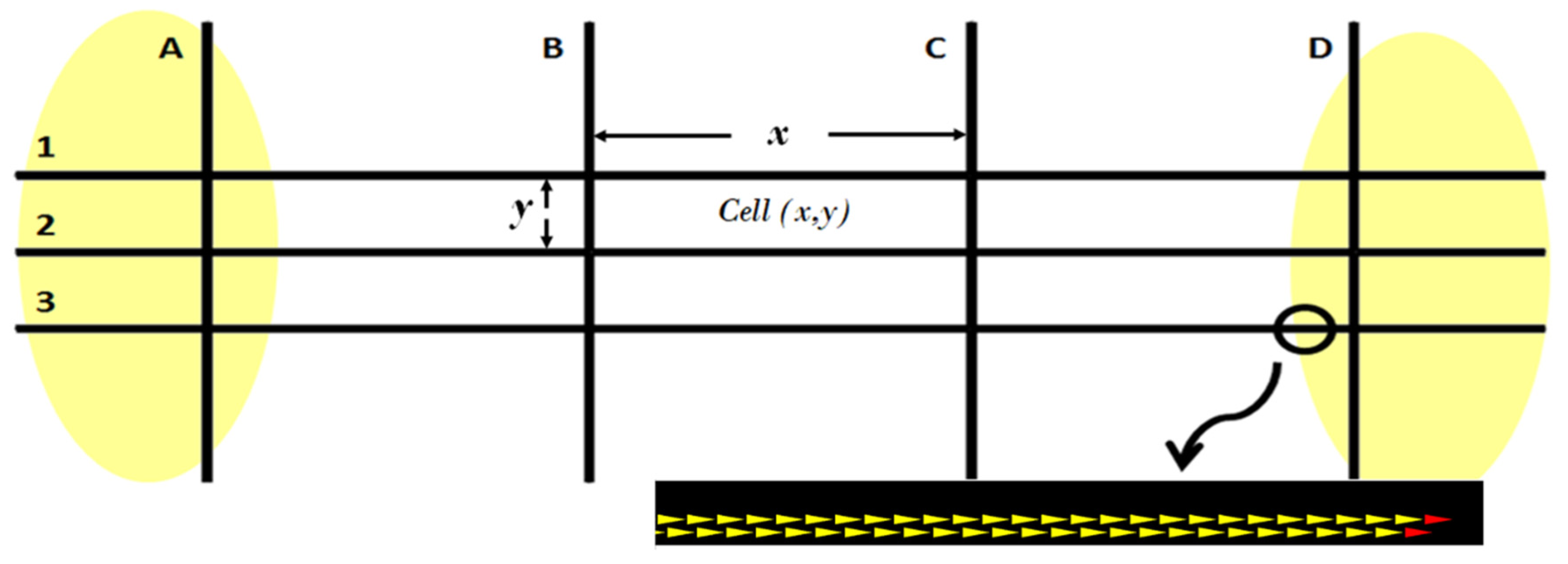
3. Materials and Methods

3.1. Ant Colony Optimization

Ant Colony Optimization (ACO) is a robust metaheuristic widely employed to derive approximate solutions for complex discrete optimization problems. Central to the ACO framework is the process wherein artificial ants construct solutions based on pheromone trails that evaporate over time. The duration of this process is a critical parameter, as it directly influences the convergence rate and the quality of the solutions obtained. Therefore, understanding and managing the aggregation time is essential for the efficiency and effectiveness of the ACO-based system we introduce.
Ant Aggregation. Ants execute aggregation by dropping pheromone marks on the path they traverse. This aggregation has two main characteristics: (1) The process is similar to the SUM function, as several drops in the same spot increase the concentration by addition. (2) The function is duplicate-sensitive, as there is no mechanism to isolate two drops from the same ant. Ant aggregation differs from typical aggregation systems because it presents evaporation, an action that clears memory over time. It is an essential process in nature that avoids perpetuating solutions that are no longer useful.
The Mechanism of Minimum Cost Path Selection. In nature, ants are very effective at finding minimum-cost paths. Inspired by this behavior, Dorigo and colleagues introduced ant colony optimization [80,81]. When ants are presented with a food supply that may be reached only by crossing one of two bridges of different lengths, they generally pick the shortest bridge. Initially, some ants may use the shortest bridge, and others may choose the other one. While walking, ants drop pheromones to mark the trail. The ants that began using the shortest bridge will arrive earlier at the food source and then return, guided by the scent of the trail they just used. Because the ants release more pheromones as they walk, the scent concentration on the shortest path will increase faster. The process is more complicated as it can be influenced by factors such as evaporation, drop frequency modulated by the quality of the food supply, and sensor imperfection, amongst others. Evaporation is an important process that assists in minimizing the impact of wrong decisions and reduces interest in a path in the event of food depletion. Recruited workers are more likely to choose the route with a stronger scent. Therefore, intensity is reinforced on this path, making the selection easier for the next recruited workers.
Inspired by the path selection behavior of these insects, artificial ants have been used to solve minimal-cost path selection in telecommunication and road network systems. Typically, these ants mark the arcs they have visited when coming only. This action is accomplished according to Equation (1). τ i j represents, at node i, the intensity of pheromone scent for the arc between nodes i and j. A traveling ant k updates the intensity by an amount of pheromone Δ τ k . The formula also shows the evaporation factor ρ .
τ i j ρ τ i j + Δ τ k

3.2. The Inspiring Algorithm

In this paper, we extend our previous work, the Reverse Online Algorithm for Dynamic Traffic Assignment inspired by Ant Colony Optimization (Road-ACO) [41]. This algorithm dynamically allocates traffic in real time without prior knowledge of future traffic demands or vehicle schedules. It employs position-aware agents, referred to interchangeably as ants or vehicles, in a Vehicular Ad Hoc Network (VANET), which possess the following capabilities:
  • Pheromone Broadcasting: Vehicles disseminate pheromone information to nearby vehicles, facilitating indirect communication.
  • Map Awareness: Vehicles can access the road map stored in memory, enabling informed navigation decisions.
  • Perceived Edge Costs: Vehicles maintain information on the costs of traversing specific road segments, reflecting current traffic conditions.
  • Selfish Shortest Path Computation: Vehicles execute shortest path algorithms in a manner consistent with the Stochastic User Equilibrium (S-UE), prioritizing individually optimal routes.
A distinctive feature of Road-ACO is its innovative use of pheromones. Unlike traditional ant colony optimization algorithms, where higher pheromone concentrations indicate more favorable paths, Road-ACO employs a reverse pheromone mechanism:
  • Inverse Pheromone Signaling: Higher pheromone intensities denote road segments of lower quality, such as those experiencing congestion or delays.
  • Global Pheromone Awareness: Agents make routing decisions based on pheromone concentrations across the entire map, not just at their current location, allowing for a comprehensive assessment of network conditions.
This approach mirrors real-world scenarios where pheromone evaporation signifies diminishing resource quality. In Road-ACO, pheromone evaporation enhances route quality over time; decreasing pheromone levels indicates reduced congestion on those paths.
In summary, Road-ACO leverages position-aware agents with comprehensive map knowledge and a novel pheromone signaling mechanism to dynamically assign traffic in real-time, effectively adapting to evolving traffic conditions without prior demand forecasts.

3.3. The Algorithm

This section introduces the Multi-hop Traffic Assignment algorithm inspired by Ant Colony Optimization (MTA-ACO). MTA-ACO builds upon our previous algorithm, Road-ACO [41], by enabling multi-hop operation. It uses a speed threshold to request information from surrounding vehicles and ant aggregation to generate reports on traffic conditions. An aggregation time window allows sufficient information to arrive before reporting adverse traffic conditions. The algorithm’s operation is based on message passing. The different types of messages used by the algorithm are:
  • Report-Request Message: Sent by a vehicle experiencing low-speed conditions to solicit speed data from nearby vehicles within the same road segment. This facilitates consensus-building regarding traffic conditions.
  • Report Message: Contains the speed information of a vehicle, shared in response to a report-request message, contributing to the collective assessment of traffic flow.
  • Traffic-Incident Message: Disseminated when a consensus indicates an adverse traffic condition, alerting other vehicles to incidents causing reduced speeds in the road segment.
  • Rebroadcast Message: Scheduled by vehicles upon receiving a traffic-incident message, ensuring widespread dissemination unless another nearby vehicle has already rebroadcasted it, optimizing communication efficiency.
If a vehicle perceives that traffic flows normally, no message is passed. If a vehicle observes a low-speed condition, it will send a report-request message to determine a consensus with nearby vehicles. If a consensus is reached, a traffic-incident message is sent. Any vehicle receiving a traffic-incident message will schedule a rebroadcast message, but it will rebroadcast it unless a nearby vehicle rebroadcasts it first. The algorithm can be represented as a state machine, as illustrated in Figure 2. The algorithm starts with the base algorithm; this program executes for an entire aggregation period. At the end of the aggregation period, it will switch to the report-request algorithm if the average speed drops below a certain threshold. Otherwise, it will repeat. The report-request algorithm will return to the base algorithm at the end of one aggregation period. The details of the base algorithm and the request report algorithm are presented in the following sections.

3.3.1. The Base Algorithm

The simulation framework is initialized with a routing file containing information about each vehicle’s origin-destination pair, departure time, and the shortest path route. The base algorithm is illustrated in Algorithm 1. During an aggregation period, each vehicle applies evaporation to the map and calculates the moving average of its speed, avgSpeed. While performing this, a response with the vehicle’s average speed is sent if a new report-request message is received from a vehicle on the same road segment. If a traffic-incident message or a never-before-rebroadcasted message is received by a vehicle, it will update its map with the new pheromone drop information. It would then select the best route under the updated conditions and prepare for rebroadcast. In this case, to avoid the broadcast storm, the vehicle starts a new aggregation period; this action blocks new report requests from this vehicle during this period. If a rebroadcast message received matches the ID of one message in the rebroadcast queue, that message is removed from the queue. The rebroadcast schedule of the algorithm is so essential for the system’s operation that we explain it in the next section. At the end of the period, if the speed drops below a set threshold, the request report algorithm is executed; this algorithm is explained in Section 3.3.3.
Algorithm 1. The Base Algorithm
1:WHILE the Vehicle is on the road
2:  FOR An aggregation period
3:    Apply evaporation to the map
4:    Calculate moving average speed (avgSpeed)
5:    IF a message is received, THEN
6:      CASE
7:        report-request
8:          IF On the same road segment as the requesting vehicle, THEN
9:            Report Speed
10:            Begin a new aggregation period
11:        traffic-incident
12:          Update map with received pheromone drop
13:          Select the best route available
14:          Set the time to rebroadcast
15:          Place the message in rebroadcast in the queue
16:          Start a new aggregation period
17:        Rebroadcasted message
18:          IF a message with the same ID is in the queue, THEN
19:            Remove the message from the queue
20:          ELSE
21:            Update map with received pheromone drop
22:            Select the best route available
23:            Set the time to rebroadcast
24:            Place message to rebroadcast in queue
25:            Start a new aggregation period
26:      END CASE
27:    END IF
28:  END FOR
29:  IF avgSpeed < speedThreshold THEN
30:CALL Request Report
31:END WHILE

3.3.2. The Rebroadcast Schedule

VANET transceivers transmit signals with a maximum reach of 1000 m, but in real life, many road segments are longer than that. A traffic-incident message from an incident near the exit of a long section could not reach vehicles entering the road segment. Therefore, traffic congestion would possibly occur. To enable the use of the algorithm for long road segments, we designed it to be rebroadcasting. Once a traffic incident is reported, vehicles receiving this message will prepare for rebroadcasting by scheduling an individual rebroadcasting time. Any vehicle holding a scheduled rebroadcast message will cancel if it detects another vehicle has rebroadcasted it first. Variable tTR stores the time to rebroadcast. It is a function of eL, rVP, and aP, the length of the edge on which the receiving vehicle is on, the position of the receiving vehicle on that edge, and the position of the incident, respectively. An illustration of the receiving vehicle variables is presented in Figure 3.
Equation (2) is used to calculate tTR, for vehicles on the same edge as the incident. This equation indicates:
  • tTR becomes smaller as the distance to the incident increases.
  • The maximum value of tTR, 1 / α , occurs when the receiving vehicle is in the exact location of the incident. For our simulations, we chose α = 0.10 . This would yield a maximum rebroadcasting time of 10 s.
  • Two vehicles on opposite sides of the incident, but at equal distances, would have the same tTR.
    t T R = 1 r V P a P + α e L / e L
The formula for tTR is designed to prioritize rebroadcasting from vehicles farther from the incident by assigning them shorter rebroadcasting times, promoting faster propagation over long distances. The term αeL prevents excessively long delays for vehicles near the incident, limiting their maximum rebroadcasting time to 10 s. Channel congestion is avoided by reducing redundant rebroadcasts if many vehicles are near the incident. Conversely, if only a few vehicles are near the incident, the design allows more vehicles to enter the affected road segment and participate in rebroadcasting.
For vehicles on a different edge from that of the incident, Equation (3) is used to calculate tTR. Vehicles near the intersection at a greater distance from the incident are favored to retransmit earlier.
t T R = 1 e L r V P / e L

3.3.3. The Request-Report Algorithm

The request-report algorithm, detailed in Algorithm 2, initiates by commencing a new aggregation period and broadcasting a request-report message. Throughout this period, the algorithm computes several key variables:
  • mc: the total number of messages received.
  • cc: the count of vehicles in consensus, defined as those with speeds below a specified threshold (speedThreshold).
  • ras: the received average speed.
Here, mc is determined by tallying all received messages, while cc counts how many of these messages report speeds under the speedThreshold. After the aggregation cycle, the algorithm evaluates the consensus ratio (cr = cc/mc). If cr surpasses a predefined consensus threshold (consensusThreshold), the system dispatches a traffic-incident message containing a pheromone drop (fd). The calculation of fd is expressed in Equation (4):
f d = f f t t + a v g t t ( c c 1 ) / m c
In this formula,
  • fftt: free-flow travel time, computed by dividing the road segment length by the speed limit.
  • avgtt: average travel time, calculated by dividing the road segment length by ras.
Equation (2) indicates that fd represents a derived travel time. When only one message is in consensus (cc = 1), fd simplifies to fftt. Conversely, if all vehicles are in consensus and the average speed is low, fd approaches avgtt. In intermediate scenarios, fd reflects a weighted average between fftt and avgtt, providing a nuanced measure of current traffic conditions.
Algorithm 2. The Request-Report Algorithm
1:Begin a new aggregation period
2:Send a request-report message
3:FOR One aggregation period
4:  IF A response message to the request is received, THEN
5:    IF the received speed is under the speed threshold
6:      Increase the consensus count “cc
7:      Increase the message count “mc
      Include the received speed in the received average speed “ras
8:    ELSE
9:      Increase the message count “mc
10:END FOR
11:Calculate consensus ratio “cr = cc/mc
12:IF cr > consensusThreshold
13:  Calculate the pheromone drop “fd
14:  Send a Traffic-Incident message with fd, vehicle ID, and road segment ID
30:RETURN

3.4. Simulation Framework
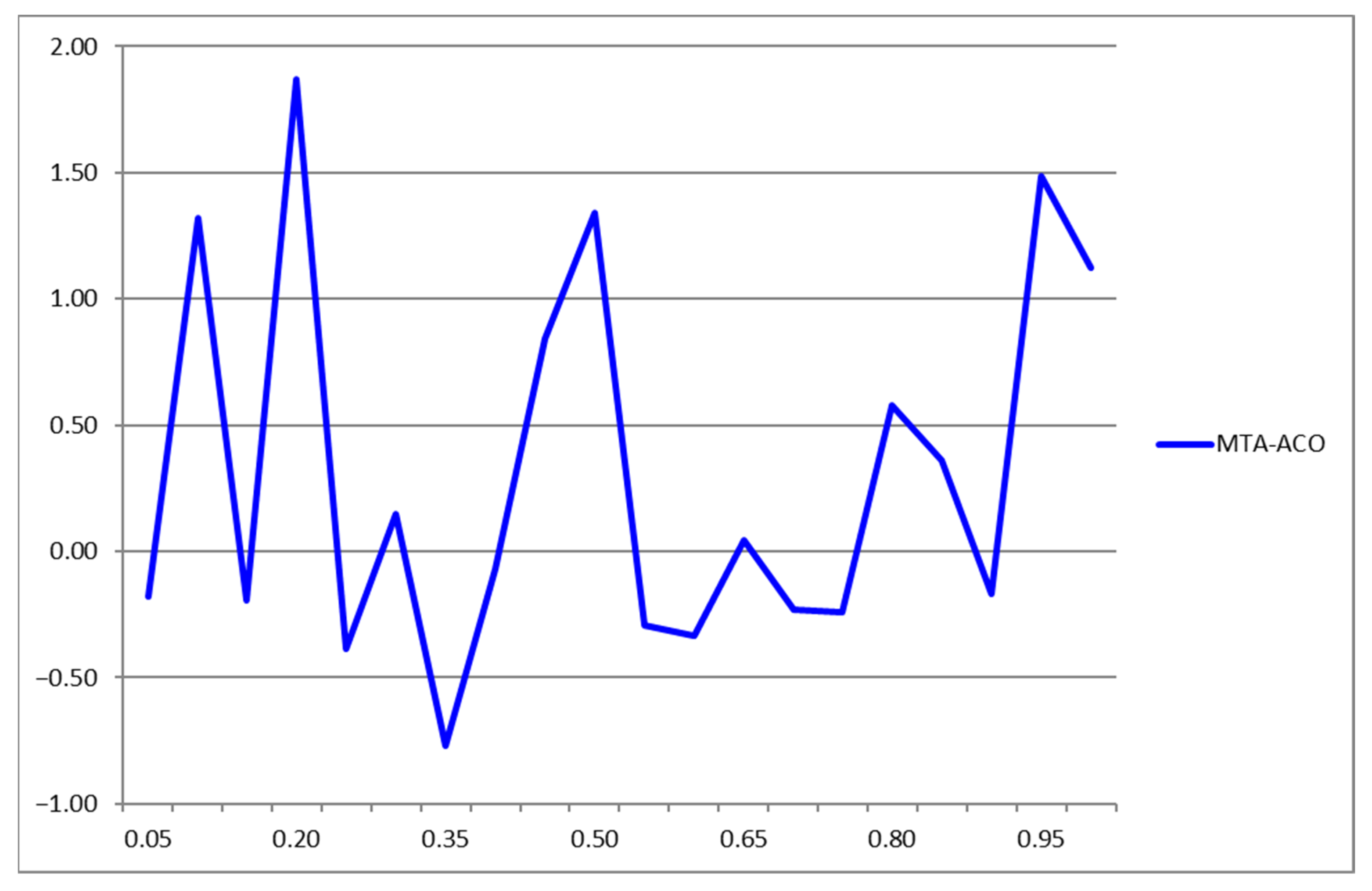
We conducted simulations using two aggregation periods: 2 s and 10 s. The 2 s period was chosen to enable frequent updates and faster incident detection but increases computational load and communication overhead, generating five times as many messages and route computations as the 10 s period. The 10 s period, selected as a practical upper limit, balances computational efficiency with performance, providing sufficient time for vehicles to detect incidents and adjust routes dynamically. However, if incidents are not reported during the initial period—such as when vehicles have not reached a consensus—additional aggregation periods may be required, potentially delaying incident detection. Simulations were conducted using the Veins framework [82,83], which integrates the SUMO road traffic simulator [84] and the OMNeT++ event simulator [85]. This bidirectional framework provides detailed modeling of IEEE 802.11p and IEEE 1609.4 DSRC/WAVE network layers, including multi-channel operations, enabling realistic VANET simulations [82].
The algorithm was tested on a 4 × 3 Manhattan grid road system [86], illustrated in Figure 4, consisting of four vertical avenues (A to D) and three horizontal streets (1 to 3). Each road segment has four lanes, two in each direction. Multiple grid configurations were analyzed, with avenue segment lengths set to one-fourth of street segment lengths. For example, a grid with cell dimensions (500 m × 125 m) features 500 m street segments and 125 m avenue segments. Additional grids tested include (1000 m × 250 m), (1750 m × 437.5 m), (4000 m × 1000 m), and (8000 m × 2000 m). To maintain smooth traffic flow at the network boundaries, peripheral road segments were fixed at 1000 m in length, reducing congestion as vehicles entered the system. The speed limit across all roads was set to 100 km/h.
The graphic tool trafficmodeler [87], extended according to [88], is used to model the traffic demand. The traffic originates at random origins in the ellipse on the left, flows towards the ellipse on the right, and ends at arbitrary destinations within it. It is left-to-right traffic, but vehicles may travel some segments in the opposite direction if the algorithm requires it to obtain a better route. A simulated incident occurs close to the intersection of Avenue D and Street 3. The incident lasts 3300 s and is illustrated by the zoomed circle in Figure 4. The red vehicles involved produce a complete traffic block on that segment, close to the end of it. This location greatly impacts traffic as the incident could trap many vehicles.
All vehicles enter the simulation over a one-hour period. For the system with a (500 m × 125 m) cell size, the traffic demand was reduced to 900 vehicles to prevent a gridlock that would otherwise occur due to the limited road system size. In all other cases, the traffic demand consisted of 1800 vehicles. Gridlocks, a frequent issue in Manhattan grid layouts, arise from high intersection congestion under heavy traffic conditions. To ensure a fair evaluation, we compared the road system’s performance with the algorithm against its performance without it. Using the average travel time without the algorithm as the reference, a gridlock would artificially inflate the algorithm’s performance by excessively increasing the baseline travel time. Figure 5 illustrates this phenomenon, showing the gridlock occurring at an intersection.
In the next section, we present the simulation results. The new multi-hop algorithm, MTA-ACO, will be compared to the Road-ACO for two values of the aggregation period. The aggregation period is the interval used to reach a consensus among vehicles near the incident on the need to send a traffic-incident message. Results show that this is a crucial parameter affecting the algorithm’s efficacy.

4. Results

In this section, we evaluate the performance of the MTA-ACO and Road-ACO algorithms under varying conditions. Specifically, we examine two aggregation periods (10 and 2 s) and assess 20 different pheromone evaporation factors, ranging from 0.05 to 1.00. Utilizing the Veins framework, we extract the average travel times of vehicles within the simulation environment. We compare scenarios where no algorithm is applied (i.e., shortest path selection) against those employing MTA-ACO and Road-ACO. The effectiveness of each algorithm is quantified by calculating the percentage change in average travel time relative to the baseline scenario without algorithmic intervention. The maximum speed in the road systems we study is 100 km/h or 27.78 m/s.

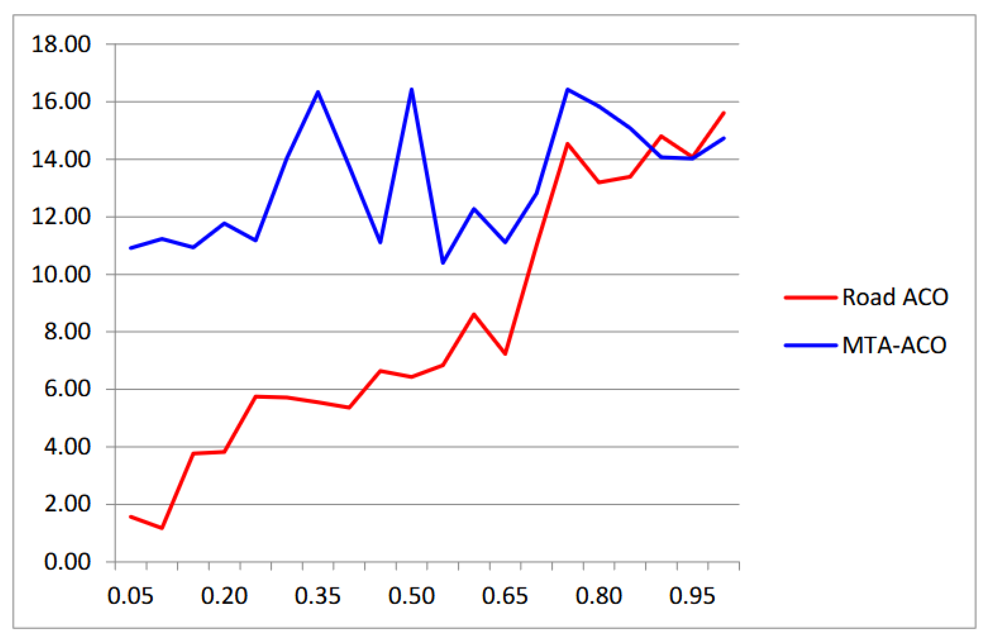
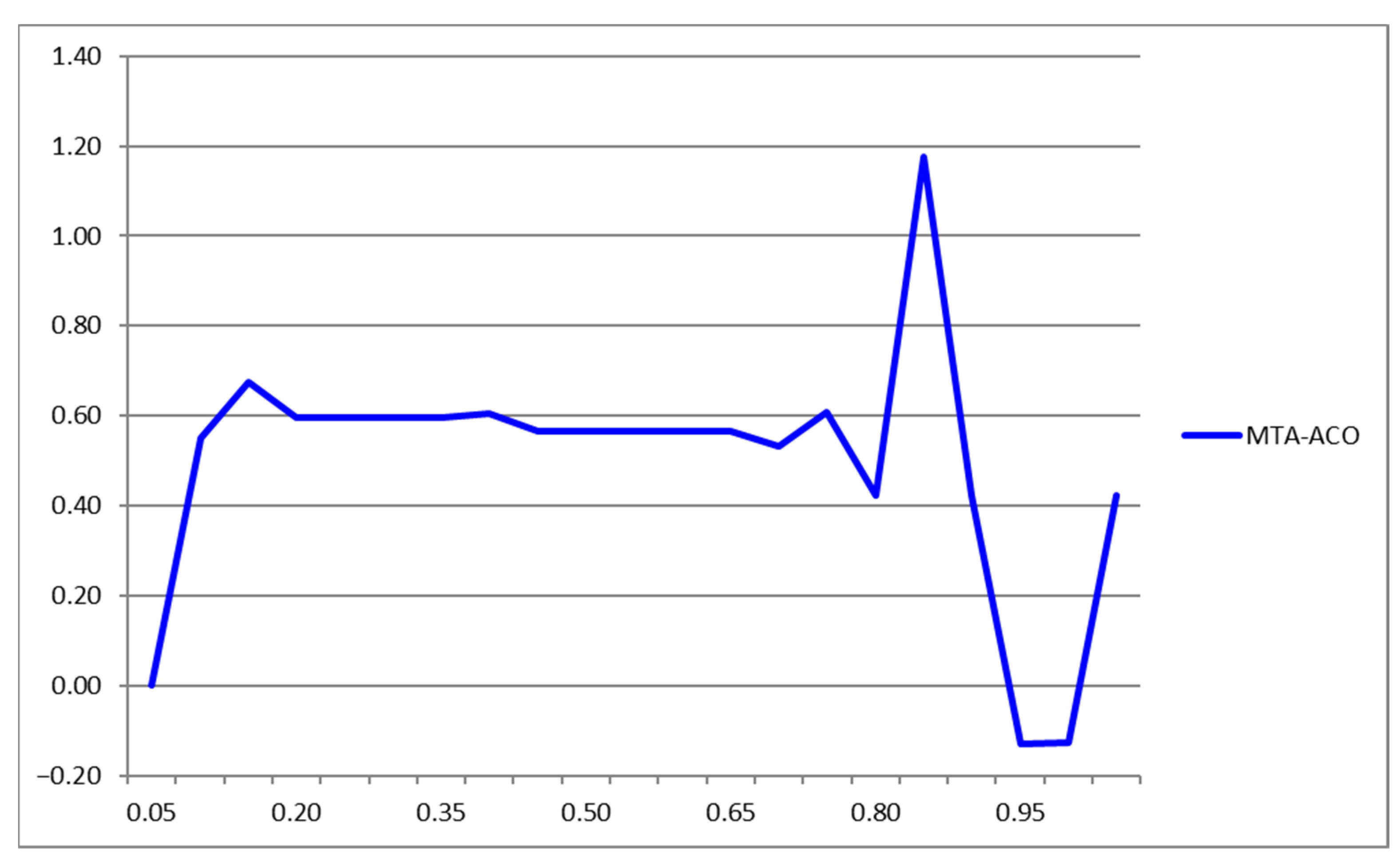
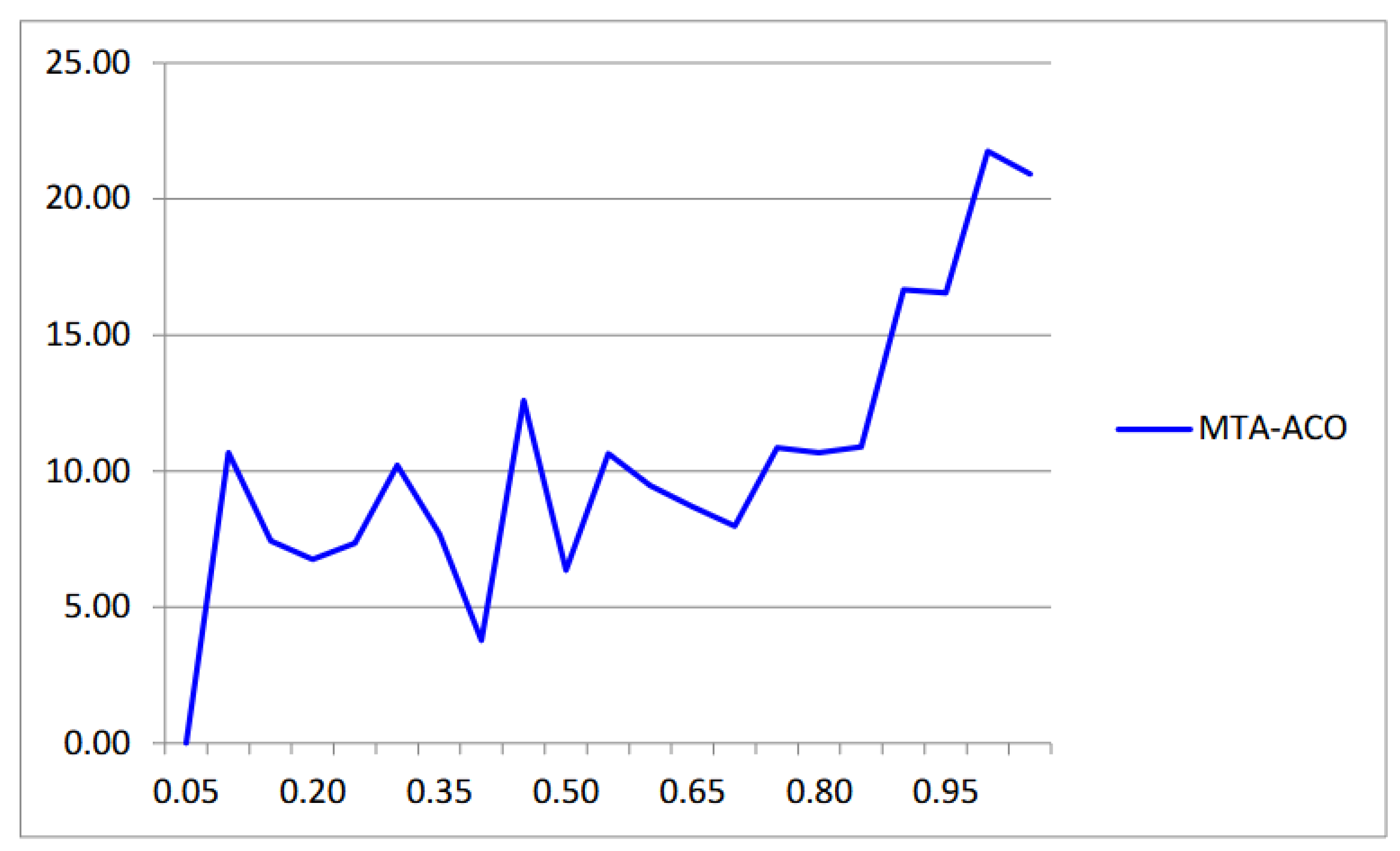
4.1. Simulation Results for Aggregation Period of 10 s

When the aggregation interval is set to 10 s, forming a cluster and reporting an incident can be delayed. For example, if both vehicles involved in an incident are the first to enter a particular road segment, one vehicle will detect the issue and broadcast a request-report message, then wait for the 10 s aggregation period to collect reports from approaching vehicles. During this interval, vehicles within approximately 278 m of the entry point to this segment may enter the affected area before the incident is reported. As previously explained, this occurs because the speed in the road systems we study is 100 km/h (27.78 m/s). With a 10 s aggregation period, vehicles can travel up to 278 m before the incident is reported. If the incident is not reported during the initial aggregation period—perhaps because approaching vehicles are still moving and have not reached a consensus on the problem—additional 10 s aggregation periods will be required to generate the incident report. This extended reporting time negatively impacts the algorithm’s performance, as timely incident detection is crucial for effective traffic management.
Figure 6, Figure 7 and Figure 8 present simulation results for systems with cell sizes of (500 m × 125 m), (1000 m × 250 m), and (1750 m × 437.5 m), each evaluated with a 10 s aggregation period. The data indicate that segment lengths influence traffic improvement. Specifically, travel time reductions of approximately 14% and 16% were observed for cell sizes of (500 m × 125 m) and (1000 m × 250 m), respectively. However, no significant improvement was noted for segment lengths exceeding 1000 m. This lack of enhancement is attributed to the prolonged aggregation period; multiple such periods may be necessary to report an event, during which numerous vehicles could become ensnared in the affected segment before receiving a warning, adversely affecting average travel time.
Furthermore, the dependency of traffic improvement on the evaporation factor exhibited consistent behavior solely for the system with a cell size of (1000 m × 250 m). In contrast, for the (500 m × 125 m) system, minor variations in the evaporation factor could shift the optimal algorithm between MTA-ACO and Road-ACO, complicating the real-world implementation of the new algorithm. The subsequent section explores promising results achieved with a reduced aggregation period of 2 s.

4.2. Simulation Results for Aggregation Period of 2 s

This section presents the results obtained with an aggregation period of 2 s. Figure 9, Figure 10, Figure 11 and Figure 12 illustrate the simulation outcomes for systems with cell sizes of (500 m × 125 m), (1750 m × 437.5 m), (4000 m × 1000 m), and (8000 m × 2000 m). The data reveal that travel time improvements exceeding 40% were achieved for cell sizes of (500 m × 125 m) and (1750 m × 437.5 m), and over 20% for the (4000 m × 1000 m) system. However, no significant improvement was observed for the (8000 m × 2000 m) system. Notably, the most substantial enhancements occurred when the evaporation factor was approximately 0.95 across all systems that exhibited improvement. This consistency simplifies the implementation of the algorithm with a 2 s aggregation period.

5. Discussion

In this study, we introduced MTA-ACO, a novel multi-hop traffic assignment algorithm designed to optimize traffic flows in large-scale road networks. Unlike the single-hop Road-ACO algorithm, MTA-ACO leverages multi-hop communication and dynamic consensus-building to detect and mitigate traffic congestion more effectively. This section provides a detailed analysis of the results and contextualizes them within the framework of the simulations.
The simulations were limited to vehicles traveling in the same direction on a Manhattan grid, with road segment lengths ranging from 500 to 8000 m and two aggregation periods (2 and 10 s). The results are shown in Table 1 and highlight MTA-ACO’s capability to significantly improve average travel times, particularly for shorter aggregation periods and moderate road segment lengths. Specifically, when the aggregation period was set to 2 s, MTA-ACO achieved travel time reductions exceeding 40% for road systems with segment lengths of up to 1750 m, compared to baseline scenarios with no algorithmic intervention. On longer road segments (e.g., 4000 m), the algorithm still provided substantial improvements of up to 22%, but with diminishing returns for segments exceeding this threshold.
In contrast, with a 10 s aggregation period, MTA-ACO performance was less consistent. For shorter road segment lengths (500 to 1000 m), travel time improvements of approximately 14–16% were observed. However, the longer aggregation period introduced delays in detecting and disseminating traffic incident information, reducing effectiveness on longer road segments. Vehicles entering the affected areas during this period often became trapped in congestion before an incident report could be generated and propagated.
The fact that these results were obtained using a Manhattan grid for our simulation strongly suggests the algorithm’s potential applicability in urban environments with similar grid-like layouts, such as San Francisco, Boston, London, and other densely populated cities worldwide. Additionally, the algorithm shows promise for use in suburban areas where highways run in parallel, such as I-95 and the Turnpike in certain regions of Florida.
The simulations also reveal the influence of the pheromone evaporation factor, a parameter central to the algorithm’s operation. The optimal evaporation factor for MTA-ACO was approximately 0.95 across most scenarios, indicating a consistent balance between maintaining relevant traffic information and clearing outdated data. This consistency simplifies the algorithm’s implementation and tuning for practical applications.
The results demonstrate MTA-ACO’s potential for improving traffic management in urban environments with grid-like layouts, such as Manhattan. The algorithm’s scalability and adaptability suggest broader applicability, particularly in densely populated urban areas, suburban networks with parallel highway systems, or even different geometry. However, addressing the limitations of longer road segments and sparse traffic densities will be critical for expanding its usability. Further research is warranted to explore these aspects and enhance the algorithm’s robustness in diverse real-world scenarios.

6. Conclusions

In this study, we introduced MTA-ACO, a novel rebroadcasting algorithm designed for the Dynamic Traffic Assignment (DTA) domain within Vehicular Ad Hoc Networks (VANETs). This algorithm addresses critical challenges in traffic management, where real-time decision-making and decentralized coordination are essential. Simulation results demonstrated that MTA-ACO outperforms its predecessor, Road-ACO, on road segments up to 4000 m in length, achieving average travel time reductions of up to 40%.
The simulated Manhattan grid used in this study underscores MTA-ACO’s potential applicability in urban environments characterized by grid-like road networks. Cities such as New York, San Francisco, and Boston share similar layouts, where parallel avenues and perpendicular streets create highly structured traffic patterns. MTA-ACO’s ability to manage dynamic traffic conditions and reduce congestion could significantly benefit such urban areas. Additionally, its scalability suggests applications in suburban regions with parallel highways or industrial zones with predictable traffic flows.
The findings of this study hold significant implications for urban traffic management and intelligent transportation systems. MTA-ACO represents a promising step toward more efficient and scalable traffic solutions by enabling adaptable, decentralized traffic management and reducing infrastructure costs.
Future work could incorporate store-carry-forward mechanisms to address low-density traffic conditions and explore hybrid communication models that integrate VANETs with existing infrastructure, such as cellular networks, to enhance robustness. Refining the testbed to support bidirectional traffic scenarios and improving computational efficiency for large-scale simulations are critical areas for further research.

Author Contributions

Conceptualization, W.A. and I.M.; methodology, W.A. and I.M.; software, W.A.; validation, W.A. and I.M.; formal analysis, W.A. and I.M.; investigation, W.A. and I.M.; resources, W.A.; writing—original draft preparation, W.A.; writing—review and editing, W.A. and I.M.; visualization, W.A. and I.M.; supervision, I.M.; project administration, I.M. All authors have read and agreed to the published version of the manuscript.

Funding

This research received no external funding.

Data Availability Statement

Data available upon request.

Conflicts of Interest

The authors declare no conflict of interest.

References

  1. Schrank, D.; Albert, L.; Jha, K.; Eisele, B. 2023 URBAN MOBILITY REPORT. Texas A&M Transportation Institute, Jun. 2024. Available online: https://static.tti.tamu.edu/tti.tamu.edu/documents/mobility-report-2023.pdf (accessed on 30 January 2024).
  2. Dutta, A.; Campoverde, L.M.S.; Tropea, M.; De Rango, F. A Comprehensive Review of Recent Developments in VANET for Traffic, Safety & Remote Monitoring Applications. J. Netw. Syst. Manag. 2024, 32, 73. [Google Scholar] [CrossRef]
  3. Wang, Y.; Zen, H.; Sabri, M.F.M.; Wang, X.; Kho, L.C. Towards Strengthening the Resilience of IoV Networks—A Trust Management Perspective. Future Internet 2022, 14, 202. [Google Scholar] [CrossRef]
  4. Amin-Naseri, M. Adopting and Incorporating Crowdsourced Traffic Data in Advanced Transportation Management Systems. Ph.D. Thesis, Iowa State University, Ames, IA, USA, 2018. [Google Scholar]
  5. D’Andrea, E.; Marcelloni, F. Detection of traffic congestion and incidents from GPS trace analysis. Expert Syst. Appl. 2017, 73, 43–56. [Google Scholar] [CrossRef]
  6. Hancock, J.; Ren, J. Accurate Traffic State Prediction with Deep Learning—Analyzing Statistical Aides for Identifying Anomalous Traffic Trends. In Proceedings of the 2024 IEEE 30th International Conference on Parallel and Distributed Systems (ICPADS), Belgrade, Serbia, 10–14 October 2024; pp. 408–414. [Google Scholar] [CrossRef]
  7. Hassan, M.U.; Al-Awady, A.A.; Ali, A.; Sifatullah; Akram, M.; Iqbal, M.M.; Khan, J.; Ali, Y.A.A. ANN-Based Intelligent Secure Routing Protocol in Vehicular Ad Hoc Networks (VANETs) Using Enhanced AODV. Sensors 2024, 24, 818. [Google Scholar] [CrossRef]
  8. Hamdi, M.M.; Al-Dosary, O.A.R.; Alrawi, O.A.S.; Mustafa, A.S.; Abood, M.S.; Noori, M.S. An overview of challenges for data dissemination and routing protocols in VANETs. In Proceedings of the 2021 3rd International Congress on Human-Computer Interaction, Optimization and Robotic Applications (HORA), Ankara, Turkey, 11–13 June 2021; pp. 1–6. [Google Scholar] [CrossRef]
  9. Limouchi, E.; Mahgoub, I. Volunteers dilemma game inspired broadcast scheme for vehicular ad hoc networks. IEEE Trans. Intell. Transp. Syst. 2019, 20, 4439–4449. [Google Scholar] [CrossRef]
  10. Slavik, M.; Mahgoub, I. Statistical broadcast protocol design for unreliable channels in wireless ad-hoc networks. In Proceedings of the 2010 IEEE Global Telecommunications Conference GLOBECOM 2010, Miami, FL, USA, 6–10 December 2010; pp. 1–5. [Google Scholar]
  11. Slavik, M.; Mahgoub, I. Spatial Distribution and Channel Quality Adaptive Protocol for Multihop Wireless Broadcast Routing in VANET. IEEE Trans. Mob. Comput. 2013, 12, 722–734. [Google Scholar] [CrossRef]
  12. Rathod, M.; Mahgoub, I.; Slavik, M. A hybrid data dissemination scheme for VANETs. In Proceedings of the 2011 IFIP Wireless Days (WD), Niagara Falls, ON, Canada, 10–12 October 2011; pp. 1–7. [Google Scholar]
  13. Slavik, M.; Mahgoub, I. Stochastic Broadcast for VANET. In Proceedings of the 2010 7th IEEE Consumer Communications and Networking Conference, Las Vegas, NV, USA, 9–12 January 2010; pp. 1–5. [Google Scholar] [CrossRef]
  14. Limouchi, E.; Mahgoub, I.; Alwakeel, A. Fuzzy logic-based broadcast in vehicular ad hoc networks. In Proceedings of the 2016 IEEE 84th Vehicular Technology Conference (VTC-Fall), Montreal, QC, Canada, 18–21 September 2016; pp. 1–5. [Google Scholar]
  15. Marwah, G.P.K.; Jain, A.; Malik, P.K.; Singh, M.; Tanwar, S.; Safirescu, C.O.; Mihaltan, T.C.; Sharma, R.; Alkhayyat, A. An Improved Machine Learning Model with Hybrid Technique in VANET for Robust Communication. Mathematics 2022, 10, 4030. [Google Scholar] [CrossRef]
  16. Sabbagh, A.A.; Shcherbakov, M.V. A Secure and Stable Routing Protocol for VANET Under Malicious Attacks. In Creativity in Intelligent Technologies and Data Science; Kravets, A.G., Shcherbakov, M., Parygin, D., Groumpos, P.P., Eds.; Communications in Computer and Information Science; Springer International Publishing: Cham, Switzerland, 2021; Volume 1448, pp. 421–435. [Google Scholar] [CrossRef]
  17. Alzamzami, O.; Mahgoub, I. Fuzzy logic-based geographic routing for urban vehicular networks using link quality and achievable throughput estimations. IEEE Trans. Intell. Transp. Syst. 2018, 20, 2289–2300. [Google Scholar] [CrossRef]
  18. Wahid, I.; Ikram, A.A.; Ahmad, M.; Ali, S.; Ali, A. State of the art routing protocols in VANETs: A review. Procedia Comput. Sci. 2018, 130, 689–694. [Google Scholar] [CrossRef]
  19. Boussoufa-Lahlah, S.; Semchedine, F.; Bouallouche-Medjkoune, L. Geographic routing protocols for Vehicular Ad hoc NETworks (VANETs): A survey. Veh. Commun. 2018, 11, 20–31. [Google Scholar] [CrossRef]
  20. Agarwal, R.K.; Mathuria, M.; Sharma, M. Study of Routing Algorithms in DTN Enabled Vehicular Ad-Hoc Network. Int. J. Comput. Appl. 2017, 159, 1–6. [Google Scholar]
  21. Alalwany, E.; Mahgoub, I. Security and trust management in the internet of vehicles (IoV): Challenges and machine learning solutions. Sensors 2024, 24, 368. [Google Scholar] [CrossRef] [PubMed]
  22. Hasrouny, H.; Samhat, A.E.; Bassil, C.; Laouiti, A. VANet security challenges and solutions: A survey. Veh. Commun. 2017, 7, 7–20. [Google Scholar] [CrossRef]
  23. Samara, G.; Al-Raba’nah, Y. Security Issues in Vehicular Ad Hoc Networks (VANET): A survey. arXiv 2017, arXiv:1712.04263. [Google Scholar]
  24. Sakiz, F.; Sen, S. A survey of attacks and detection mechanisms on intelligent transportation systems: VANETs and IoV. Ad Hoc Netw. 2017, 61, 33–50. [Google Scholar] [CrossRef]
  25. Wang, X.; Jiang, C.; Sheng, S.; Xu, Y.; Jia, Y. Stop Line Aided Cooperative Positioning of Connected Vehicles. arXiv 2021, arXiv:2112.13369. [Google Scholar] [CrossRef]
  26. Günay, F.B.; Öztürk, E.; Çavdar, T.; Hanay, Y.S.; Khan, A.U.R. Vehicular Ad Hoc Network (VANET) Localization Techniques: A Survey. Arch. Comput. Methods Eng. 2021, 28, 3001–3033. [Google Scholar] [CrossRef]
  27. Chehri, A.; Quadar, N.; Saadane, R. Communication and Localization Techniques in VANET Network for Intelligent Traffic System in Smart Cities: A Review. In Smart Transportation Systems 2020; Qu, X., Zhen, L., Howlett, R.J., Jain, L.C., Eds.; Springer: Singapore, 2020; pp. 167–177. [Google Scholar] [CrossRef]
  28. An, P.; J, P.; S, S.; Kumar, S.; R, G. Malicious Node Detection in VANETs via Enhanced DSR and ML. In Proceedings of the 2024 International Conference on Wireless Communications Signal Processing and Networking (WiSPNET), Chennai, India, 21–23 March 2024; pp. 1–7. [Google Scholar] [CrossRef]
  29. Rashid, K.; Saeed, Y.; Ali, A.; Jamil, F.; Alkanhel, R.; Muthanna, A. An Adaptive Real-Time Malicious Node Detection Framework Using Machine Learning in Vehicular Ad-Hoc Networks (VANETs). Sensors 2023, 23, 2594. [Google Scholar] [CrossRef]
  30. Sultan, S.; Javaid, Q.; Malik, A.J.; Al-Turjman, F.; Attique, M. Collaborative-trust approach toward malicious node detection in vehicular ad hoc networks. Environ. Dev. Sustain. 2022, 24, 7532–7550. [Google Scholar] [CrossRef]
  31. Arshad, M.; Ullah, Z.; Ahmad, N.; Khalid, M.; Criuckshank, H.; Cao, Y. A survey of local/cooperative-based malicious information detection techniques in VANETs. EURASIP J. Wirel. Commun. Netw. 2018, 2018, 62. [Google Scholar] [CrossRef]
  32. Sharma, S.; Kaul, A. A survey on Intrusion Detection Systems and Honeypot based proactive security mechanisms in VANETs and VANET Cloud. Veh. Commun. 2018, 12, 138–164. [Google Scholar] [CrossRef]
  33. Roocroft, A.; Punzo, G.; Ramli, M.A. Link Count Data-driven Static Traffic Assignment Models Through Network Modularity Partitioning. arXiv 2022, arXiv:2211.13514. [Google Scholar]
  34. Guidoni, D.L.; Maia, G.; Souza, F.S.H.; Villas, L.A.; Loureiro, A.A.F. Vehicular Traffic Management Based on Traffic Engineering for Vehicular Ad Hoc Networks. IEEE Access 2020, 8, 45167–45183. [Google Scholar] [CrossRef]
  35. Zhang, W.; Aung, N.; Dhelim, S.; Ai, Y. DIFTOS: A Distributed Infrastructure-Free Traffic Optimization System Based on Vehicular Ad Hoc Networks for Urban Environments. Sensors 2018, 18, 2567. [Google Scholar] [CrossRef]
  36. Pan, J.S.; Popa, I.S.; Borcea, C. Divert: A distributed vehicular traffic re-routing system for congestion avoidance. IEEE Trans. Mob. Comput. 2017, 16, 58–72. [Google Scholar] [CrossRef]
  37. Soares, P.H. Zone-based public transport route optimisation in an urban network. Public Transp. 2021, 13, 197–231. [Google Scholar] [CrossRef]
  38. Cox, T.; Thulasiraman, P. A zone-based traffic assignment algorithm for scalable congestion reduction. ICT Express 2017, 3, 204–208. [Google Scholar] [CrossRef]
  39. Liao, X.-C.; Qiu, W.-J.; Wei, F.-F.; Chen, W.-N. Combining Traffic Assignment and Traffic Signal Control for Online Traffic Flow Optimization. In Neural Information Processing; Tanveer, M., Agarwal, S., Ozawa, S., Ekbal, A., Jatowt, A., Eds.; Springer Nature: Singapore, 2023; pp. 150–163. [Google Scholar] [CrossRef]
  40. Chai, H.; Zhang, H.M.; Ghosal, D.; Chuah, C.-N. Dynamic traffic routing in a network with adaptive signal control. Transp. Res. Part C: Emerg. Technol. 2017, 85, 64–85. [Google Scholar] [CrossRef]
  41. Arellano, W.; Mahgoub, I. Reverse Online Algorithm for the Dynamic Traffic Assignment inspired by Ant Colony Optimization for VANETs. Int. J. Swarm Intel. Evol. Comput. 2014, 3, 2. [Google Scholar]
  42. Wardrop, J.G. Road paper. Some theoretical aspects of road traffic research. Proc. Inst. Civ. Eng. 1952, 1, 325–362. [Google Scholar] [CrossRef]
  43. Correa, J.R.; Schulz, A.S.; Stier-Moses, N.E. Selfish routing in capacitated networks. Math. Oper. Res. 2004, 29, 961–976. [Google Scholar] [CrossRef]
  44. Beckmann, M.; McGuire, C.B.; Winsten, C.B. Studies in the Economics of Transportation. 1956. Available online: http://trid.trb.org/view.aspx?id=91120 (accessed on 30 January 2024).
  45. Boyce, D. Beckmann’s transportation network equilibrium model: Its history and relationship to the Kuhn–Tucker conditions. Econ. Transp. 2013, 2, 47–52. [Google Scholar] [CrossRef]
  46. Frank, M.; Wolfe, P. An algorithm for quadratic programming. Nav. Res. Logist. Q. 1956, 3, 95–110. [Google Scholar] [CrossRef]
  47. LeBlanc, L.J.; Morlok, E.K.; Pierskalla, W.P. An efficient approach to solving the road network equilibrium traffic assignment problem. Transp. Res. 1975, 9, 309–318. [Google Scholar] [CrossRef]
  48. Yagar, S. Dynamic traffic assignment by individual path minimization and queuing. Transp. Res. 1971, 5, 179–196. [Google Scholar] [CrossRef]
  49. Homburger, W.S. Traffic Estimation: Computer Programs for Educational Purposes (Course Notes); Institute of Transportation and Traffic Engineering, University of California: Berkeley, CA, USA, 1969. [Google Scholar]
  50. Merchant, D.K.; Nemhauser, G.L. A Model and an Algorithm for the Dynamic Traffic Assignment Problems. Transp. Sci. 1978, 12, 183–199. [Google Scholar] [CrossRef]
  51. Peeta, S.; Ziliaskopoulos, A.K. Foundations of dynamic traffic assignment: The past, the present and the future. Netw. Spat. Econ. 2001, 1, 233–265. [Google Scholar] [CrossRef]
  52. Arellano, W.; Mahgoub, I. Swarm Intelligence-Inspired Routing Algorithms for Ad Hoc Wireless Networks. In Encyclopedia of Wireless and Mobile Communications, 2nd ed.; Furht, B., Ed.; CRC Press: Boca Raton, FL, USA, 2012. [Google Scholar]
  53. Pauer, G.; Török, Á. Improving Highly Automated Traffic Management Models Using Alternative Graph Structures Simultaneously. Appl. Sci. 2024, 14, 484. [Google Scholar] [CrossRef]
  54. Goyal, R.; Elawadhi, O.; Sharma, A.; Bhutani, M.; Jain, A. Cloud-connected central unit for traffic control: Interfacing sensing units and centralized control for efficient traffic management. Int. J. Inf. Tecnol. 2024, 16, 841–851. [Google Scholar] [CrossRef]
  55. Nguyen, T.-H.; Jung, J.J. ACO-based traffic routing method with automated negotiation for connected vehicles. Complex Intell. Syst. 2023, 9, 625–636. [Google Scholar] [CrossRef]
  56. Kumarasamy, V.K.; Saroj, A.J.; Liang, Y.; Wu, D.; Hunter, M.P.; Guin, A.; Sartipi, M. Integration of Decentralized Graph-Based Multi-Agent Reinforcement Learning with Digital Twin for Traffic Signal Optimization. Symmetry 2024, 16, 448. [Google Scholar] [CrossRef]
  57. Lilhore, U.K.; Imoize, A.L.; Li, C.-T.; Simaiya, S.; Pani, S.K.; Goyal, N.; Kumar, A.; Lee, C.-C. Design and Implementation of an ML and IoT Based Adaptive Traffic-Management System for Smart Cities. Sensors 2022, 22, 2908. [Google Scholar] [CrossRef] [PubMed]
  58. Akabane, A.T.; Immich, R.; Bittencourt, L.F.; Madeira, E.R.M.; Villas, L.A. Towards a distributed and infrastructure-less vehicular traffic management system. Comput. Commun. 2020, 151, 306–319. [Google Scholar] [CrossRef]
  59. Dion, F.; Hellinga, B. A rule-based real-time traffic responsive signal control system with transit priority: Application to an isolated intersection. Transp. Res. Part B Methodol. 2002, 36, 325–343. [Google Scholar] [CrossRef]
  60. Martí, I.; Tomás, V.R.; García, L.A.; Martínez, J.J. A Rule-Based Multi-agent System for Local Traffic Management. In Intelligent Data Engineering and Automated Learning—IDEAL 2009; Corchado, E., Yin, H., Eds.; Springer: Berlin/Heidelberg, Germany, 2009; pp. 502–509. [Google Scholar] [CrossRef]
  61. Peeta, S. System Optimal Dynamic Traffic Assignment in Congested Networks with Advanced Information Systems. Ph.D. Dissertation, University of Texas at Austin, Austin, TX, USA, 1994. [Google Scholar]
  62. Lin, J.; Hu, Q.; Lin, W.; Tan, M. Risk and resilience-based restoration optimization of transportation infrastructures under uncertainty. PLoS ONE 2024, 19, e0308138. [Google Scholar] [CrossRef]
  63. Wigan, M.R. Benefit Assessment for Network Traffic Models and Application to Road Pricing. 1971. Available online: https://trid.trb.org/View/89838 (accessed on 30 January 2024).
  64. Nagel, K.; Barrett, C.L. Using microsimulation feedback for trip adaptation for realistic traffic in Dallas. Int. J. Mod. Phys. C 1997, 8, 505–525. [Google Scholar] [CrossRef]
  65. Zhao, S.; Liu, L.; Zhao, P. Traffic assignment in urban transportation network problem with emission constraints in China: A cooperative game theory. Environ. Sci. Pollut. Res. 2023, 30, 69274–69288. [Google Scholar] [CrossRef]
  66. Hollander, Y.; Prashker, J.N. The applicability of non-cooperative game theory in transport analysis. Transportation 2006, 33, 481–496. [Google Scholar] [CrossRef]
  67. Chen, O.; Ben-Akiva, M. Game-Theoretic Formulations of Interaction Between Dynamic Traffic Control and Dynamic Traffic Assignment. Transp. Res. Rec. J. Transp. Res. Board 1998, 1617, 179–188. [Google Scholar] [CrossRef]
  68. Huang, J.; Tan, Q.; Qi, R.; Li, H. RELight: A random ensemble reinforcement learning based method for traffic light control. Appl. Intell. 2024, 54, 95–112. [Google Scholar] [CrossRef]
  69. Azad, S.M.M.; Ramazani, A. Smart control of traffic lights based on traffic density in the multi-intersection network by using Q learning. Discov. Artif. Intell. 2023, 3, 39. [Google Scholar] [CrossRef]
  70. Rojo, M. Evaluation of Traffic Assignment Models through Simulation. Sustainability 2020, 12, 5536. [Google Scholar] [CrossRef]
  71. Fafoutellis, P.; Vlahogianni, E.I. Unlocking the Full Potential of Deep Learning in Traffic Forecasting Through Road Network Representations: A Critical Review. Data Sci. Transp. 2023, 5, 23. [Google Scholar] [CrossRef]
  72. Benarmas, R.B.; Bey, K.B. A deep learning-based framework for road traffic prediction. J. Supercomput. 2024, 80, 6891–6916. [Google Scholar] [CrossRef]
  73. Ben-Akiva, M.; Bierlaire, M.; Burton, D.; Koutsopoulos, H.N.; Mishalani, R. Network state estimation and prediction for real-time traffic management. Netw. Spat. Econ. 2001, 1, 293–318. [Google Scholar] [CrossRef]
  74. Nie, Z.-H.; Yang, Q.; Zhang, E.; Liu, D.; Zhang, J. Ant Colony optimization for Electric Vehicle Routing Problem with Capacity and Charging Time Constraints. In Proceedings of the 2022 IEEE International Conference on Systems, Man, and Cybernetics (SMC), Prague, Czech Republic, 9–12 October 2022; pp. 480–485. [Google Scholar] [CrossRef]
  75. Zhao, M. Application of an Improved Ant Colony Algorithm in Vehicle Routing Problem. In Proceedings of the 2023 4th International Conference on Computer Engineering and Intelligent Control (ICCEIC), Guangzhou, China, 20–22 October 2023; pp. 270–273. [Google Scholar] [CrossRef]
  76. Mavrovouniotis, M.; Ellinas, G.; Li, C.; Polycarpou, M. A Multiple Ant Colony System for the Electric Vehicle Routing Problem with Time Windows. In Proceedings of the 2022 IEEE Symposium Series on Computational Intelligence (SSCI), Singapore, 4–7 December 2022; pp. 796–803. [Google Scholar] [CrossRef]
  77. Soon, K.L.; Lim, J.M.-Y.; Parthiban, R.; Ho, M.C. Proactive eco-friendly pheromone-based green vehicle routing for multi-agent systems. Expert Syst. Appl. 2019, 121, 324–337. [Google Scholar] [CrossRef]
  78. S, S.S. and V, C.S.S. A Multi-agent Ant Colony Optimization Algorithm for Effective Vehicular Traffic Management. In Advances in Swarm Intelligence; Tan, Y., Shi, Y., Tuba, M., Eds.; Springer International Publishing: Cham, Switzerland, 2020; pp. 640–647. [Google Scholar] [CrossRef]
  79. Pérez-Carabaza, S.; Gálvez, A.; Iglesias, A. Extended Rank-Based Ant Colony Optimization Algorithm for Traveling Salesman Problem. In 18th International Conference on Soft Computing Models in Industrial and Environmental Applications (SOCO 2023); Bringas, P.G., García, H.P., de Pisón, F.J.M., Álvarez, F.M., Lora, A.T., Herrero, Á., Rolle, J.L.C., Quintián, H., Corchado, E., Eds.; Springer Nature: Cham, Switzerland, 2023; pp. 13–23. [Google Scholar] [CrossRef]
  80. Dorigo, M. Optimization, Learning and Natural Algorithms. Ph.D. Thesis, Politecnico di Milano, Milan, Italy, 1992. Available online: http://ci.nii.ac.jp/naid/10016599043/ (accessed on 3 May 2014).
  81. Dorigo, M.; Stützle, T. Ant Colony Optimization, 1st ed.; MIT Press: Cambridge, MA, USA, 2004; Available online: https://mitpress.mit.edu/9780262042192/ant-colony-optimization/ (accessed on 30 January 2024).
  82. Sommer, C. Veins-Vehicles in Network Simulation. Available online: https://veins.car2x.org/ (accessed on 8 December 2024).
  83. Sommer, C.; Yao, Z.; German, R.; Dressler, F. Simulating the influence of IVC on road traffic using bidirectionally coupled simulators. In Proceedings of the IEEE INFOCOM Workshops 2008, Phoenix, AZ, USA, 13–18 April 2008; pp. 1–6. [Google Scholar] [CrossRef]
  84. Eclipse SUMO-Simulation of Urban MObility. Available online: https://www.eclipse.dev/sumo/ (accessed on 8 December 2024).
  85. OMNeT++ Discrete Event Simulator. Available online: https://omnetpp.org/ (accessed on 8 December 2024).
  86. Manhattan Grid—An Overview|ScienceDirect Topics. Available online: https://www.sciencedirect.com/topics/computer-science/manhattan-grid (accessed on 3 January 2025).
  87. Papaleondiou, L.G.; Dikaiakos, M.D. Trafficmodeler: A graphical tool for programming microscopic traffic simulators through high-level abstractions. In Proceedings of the VTC Spring 2009—IEEE 69th Vehicular Technology Conference, Barcelona, Spain, 26–29 April 2009; pp. 1–5. [Google Scholar] [CrossRef]
  88. Arellano, W.; Mahgoub, I. Traffic Modeler extensions: A case for rapid VANET simulation using OMNET++, SUMO, and VEINS. In Proceedings of the 2013 High Capacity Optical Networks and Emerging/Enabling Technologies, Magosa, Cyprus, 11–13 December 2013; pp. 109–115. [Google Scholar] [CrossRef]
Figure 1. Taxonomy of simulation-based models. Centralized and Decentralized algorithms are grouped in brown and green, respectively. Infrastructure Support and No Infrastructure Support are grouped in red and blue, respectively.
Electronics 14 00559 g001
Figure 2. State machine representation of the algorithm.
Electronics 14 00559 g002
Figure 3. The illustration shows a receiving vehicle at an edge with an incident. The variables eL, rVP, and aP are shown. They represent the length of the edge, the vehicle position, and the incident position. They are used to compute tTR.
Electronics 14 00559 g003
Figure 4. Simulation framework. The road system is a 4 × 3 Manhattan grid with cell sizes of (500 m × 125 m), (1000 m × 250 m), (1750 m × 437.5 m), (4000 m × 1000 m), and (8000 m × 2000 m). The system comprises four vertical avenues (A to D) and three horizontal streets (1 to 3). Traffic flows begin at origins in the ellipse on the left and terminate at destinations in the ellipse on the right. The expanded area is a snapshot from the traffic simulator SUMO.
Electronics 14 00559 g004
Figure 5. Gridlock in the system with cell size (500 m × 125 m). This snapshot from the traffic simulator SUMO illustrates a gridlock where vehicles remain stationary until the traffic incident is resolved. For instance, on the left branch, the first vehicle in the top row cannot turn left due to a blockage in the top branch, while the first vehicle in the bottom row cannot turn right. The algorithm allows vehicles to reroute and continue moving, preventing such gridlocks.
Electronics 14 00559 g005
Figure 6. System of cell size (500 m × 125 m). Aggregation period of 10 s. MTA-ACO and Road-ACO algorithms. Vertical axis: Percentage of average travel time improvement. Horizontal axis: Evaporation Factor.
Electronics 14 00559 g006
Figure 7. System of cell size (1000 m × 250 m). Aggregation period of 10 s. MTA-ACO and Road-ACO algorithms. Vertical axis: Percentage of average travel time improvement. Horizontal axis: Evaporation factor.
Electronics 14 00559 g007
Figure 8. System of cell size (1750 m × 437.5 m). Aggregation period of 10 s. MTA-ACO algorithm. Vertical axis: Percentage of average travel time improvement. Horizontal axis: Evaporation factor.
Electronics 14 00559 g008
Figure 9. System of cell size (500 m × 125 m). Aggregation period of 2 s. MTA-ACO and Road-ACO algorithms. Vertical axis: Percentage of average travel time improvement. Horizontal axis: Evaporation factor.
Electronics 14 00559 g009
Figure 10. System of cell size (1750 m × 437.5 m). Aggregation period of 2 s. MTA-ACO and Road-ACO algorithms. Vertical axis: Percentage of average travel time improvement. Horizontal axis: Evaporation factor.
Electronics 14 00559 g010
Figure 11. System of cell size (4000 m × 1000 m). Aggregation period of 2 s. MTA-ACO algorithm. Vertical axis: Percentage of average travel time improvement. Horizontal axis: Evaporation factor.
Electronics 14 00559 g011
Figure 12. System of cell size (8000 m × 2000 m). Aggregation period of 2 s. MTA-ACO algorithm. Vertical axis: Percentage of average travel time improvement. Horizontal axis: Evaporation factor.
Electronics 14 00559 g012
Table 1. Summary of the simulation results for road segment lengths ranging from 500 to 8000 m and two aggregation periods (2 and 10 s).
Travel Time Gains
Aggregation Period of 10 sAggregation Period of 2 s
SystemMTA-ACORoad-ACOMTA-ACORoad-ACO
50016%14%42%25%
100016%16%N/AN/A
17501.20%N/A42%0%
4000N/AN/A22%0%
8000N/AN/A0%%
Disclaimer/Publisher’s Note: The statements, opinions and data contained in all publications are solely those of the individual author(s) and contributor(s) and not of MDPI and/or the editor(s). MDPI and/or the editor(s) disclaim responsibility for any injury to people or property resulting from any ideas, methods, instructions or products referred to in the content.

