An Exploratory Verification Method for Validation of Sea Surface Radiance of HY-1C Satellite UVI Payload Based on SOA Algorithm
Abstract
1. Introduction
2. The Validation Method of the HY-1C Satellite’s Ultraviolet Imager
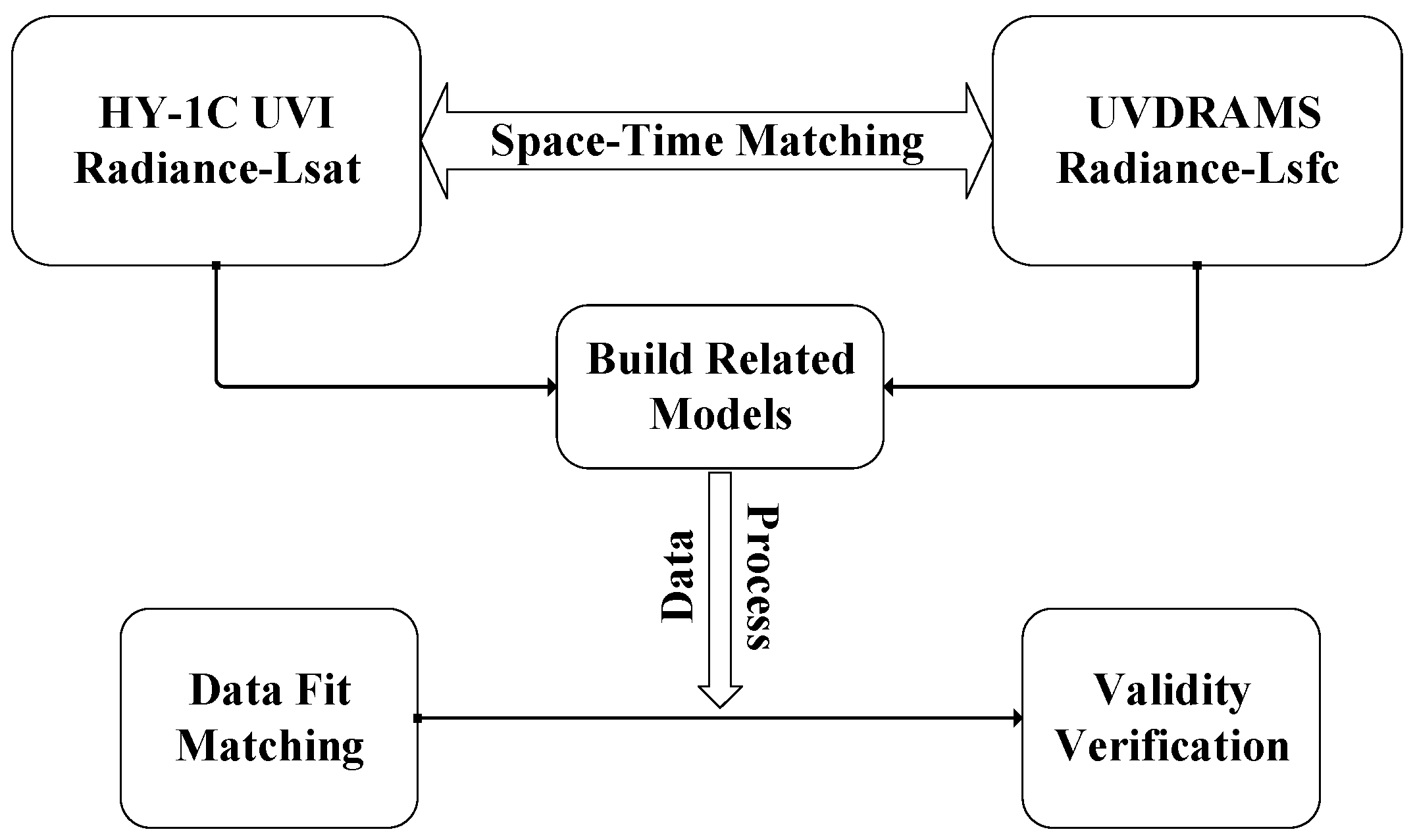
2.1. The Validation Method Principle
2.2. Modeling of Satellite–Ground Synchrotron Radiation Transport
2.3. Synchrotron Radiation Transmission Model Parameter Identification Method Based on SOA Algorithm
3. Marine In Situ Observation Field Test Verification
| Ultraviolet Dual-Band Radiance Measurement System | ||
|---|---|---|
| Detector spectrum | B1 (345 nm~365 nm) | B2 (375 nm~395 nm) |
| Center wavelength | 355 nm | 385 nm |
| SNR | >1000 (typical radiance of 7.5 mW·cm−2·um−1·sr−1) | >1000 (typical radiance of 6.1 mW·cm−2·um−1·sr−1) |
| Dynamic range (mW·cm−2·um−1·sr−1) | High dynamic of 35.6 Low dynamic of 17.5 | High Dynamic of 36.1 Low Dynamic of 18.6 |
| FOV | 23° | |
| Angular resolution | 0.68 mrad | |
| Absolute radiometric calibration accuracy | <5% | |

4. Results and Discussion
4.1. Data Analysis of Marine Field Observations
4.2. Analysis of the Synchronous Observation Data with the UVI Load
4.3. Analysis of the Satellite–Ground Synchrotron Radiation Data Based on the SOA Algorithm
5. Conclusions
Author Contributions
Funding
Data Availability Statement
Conflicts of Interest
References
- Emery, B.; Camps, A. Introduction to Satellite Remote Sensing: Atmosphere, Ocean, Land and Cryosphere Applications; Elsevier: Amsterdam, The Netherlands, 2017. [Google Scholar]
- Amani, M.; Mehravar, S.; Asiyabi, R.M.; Moghimi, A.; Ghorbanian, A.; Ahmadi, S.A.; Ebrahimy, H.; Moghaddam, S.H.A.; Naboureh, A.; Ranjgar, B. Ocean Remote Sensing Techniques and Applications: A Review (Part II). Water 2022, 14, 3401. [Google Scholar] [CrossRef]
- Amani, M.; Moghimi, A.; Mirmazloumi, S.M.; Ranjgar, B.; Ghorbanian, A.; Ojaghi, S.; Ebrahimy, H.; Naboureh, A.; Nazari, M.E.; Mahdavi, S. Ocean Remote Sensing Techniques and Applications: A Review (Part I). Water 2022, 14, 3400. [Google Scholar] [CrossRef]
- Werdell, P.J.; McKinna, L.I.; Boss, E.; Ackleson, S.G.; Craig, S.E.; Gregg, W.W.; Lee, Z.; Maritorena, S.; Roesler, C.S.; Rousseaux, C.S. An overview of approaches and challenges for retrieving marine inherent optical properties from ocean color remote sensing. Prog. Oceanogr. 2018, 160, 186–212. [Google Scholar] [CrossRef]
- Singh, R.K.; Shanmugam, P. A multidisciplinary remote sensing ocean color sensor: Analysis of user needs and recommendations for future developments. IEEE J. Sel. Top. Appl. Earth Obs. Remote Sens. 2016, 9, 5223–5238. [Google Scholar] [CrossRef]
- Wu, X.; Xiao, Q.; Wen, J.; You, D.; Hueni, A. Advances in quantitative remote sensing product validation: Overview and current status. Earth-Sci. Rev. 2019, 196, 102875. [Google Scholar] [CrossRef]
- Jin, M.; Ji, Z.; Shaomin, L.; Yujia, W. Review on validation of remotely sensed land surface temperature. Adv. Earth Sci. 2017, 32, 615. [Google Scholar]
- Jiang, H. Indirect validation of ocean remote sensing data via numerical model: An example of wave heights from altimeter. Remote Sens. 2020, 12, 2627. [Google Scholar] [CrossRef]
- Arun Kumar, S.; Babu, K.; Shukla, A. Comparative analysis of chlorophyll-a distribution from SEAWIFS, MODIS-AQUA, MODIS-TERRA and MERIS in the Arabian Sea. Mar. Geod. 2015, 38, 40–57. [Google Scholar] [CrossRef]
- Bartlett, B.; Casey, J.; Padula, F.; Pearlman, A.; Pogorzala, D.; Cao, C. Independent validation of the advanced baseline imager (ABI) on NOAA’s GOES-16: Post-launch ABI airborne science field campaign results. In Proceedings of the Earth Observing Systems XXIII, San Diego, CA, USA, 19–23 August 2018; pp. 143–157. [Google Scholar]
- McCorkel, J.; Efremova, B.; Hair, J.; Andrade, M.; Holben, B. GOES-16 ABI solar reflective channel validation for earth science application. Remote Sens. Environ. 2020, 237, 111438. [Google Scholar] [CrossRef]
- Yang, J.; Zhang, J. Validation of Sentinel-3A/3B satellite altimetry wave heights with buoy and Jason-3 data. Sensors 2019, 19, 2914. [Google Scholar] [CrossRef]
- Urabe, T.; Okamura, Y.; Tanaka, K.; Mokuno, M. In-orbit commissioning activities results of GCOM-C/SGLI. In Proceedings of the Sensors, Systems, and Next-Generation Satellites XXII, Berlin, Germany, 10–13 September 2018; pp. 88–107. [Google Scholar]
- Nakajima, T.Y.; Ishida, H.; Nagao, T.M.; Hori, M.; Letu, H.; Higuchi, R.; Tamaru, N.; Imoto, N.; Yamazaki, A. Theoretical basis of the algorithms and early phase results of the GCOM-C (Shikisai) SGLI cloud products. Prog. Earth Planet. Sci. 2019, 6, 52. [Google Scholar] [CrossRef]
- Tanaka, K.; Okamura, Y.; Mokuno, M.; Amano, T.; Yoshida, J. First year on-orbit calibration activities of SGLI on GCOM-C satellite. In Proceedings of the Earth Observing Missions and Sensors: Development, Implementation, and Characterization V, Honolulu, HI, USA, 24–26 September 2018; pp. 101–110. [Google Scholar]
- Urabe, T.; Ando, S.; Okamura, Y.; Tanaka, K.; Mokuno, M.; Amano, T.; Shiratama, K.; Yoshida, J. Pre-launch instrument characterization results and in-orbit verification plan of GCOM-C/SGLI. In Proceedings of the Sensors, Systems, and Next-Generation Satellites XXI, Warsaw, Poland, 11–14 September 2017; pp. 130–143. [Google Scholar]
- Tian, H.; Huang, N.; Niu, Z.; Qin, Y.; Pei, J.; Wang, J. Mapping winter crops in China with multi-source satellite imagery and phenology-based algorithm. Remote Sens. 2019, 11, 820. [Google Scholar] [CrossRef]
- Tian, H.; Pei, J.; Huang, J.; Li, X.; Wang, J.; Zhou, B.; Qin, Y.; Wang, L. Garlic and winter wheat identification based on active and passive satellite imagery and the google earth engine in northern china. Remote Sens. 2020, 12, 3539. [Google Scholar] [CrossRef]
- Modabberi, A.; Noori, R.; Madani, K.; Ehsani, A.H.; Mehr, A.D.; Hooshyaripor, F.; Kløve, B. Caspian Sea is eutrophying: The alarming message of satellite data. Environ. Res. Lett. 2020, 15, 124047. [Google Scholar] [CrossRef]
- Shanshan, M. A LM-2C Launches HY-1C Satellite. Aerosp. China 2018, 19, 59. [Google Scholar]
- Suo, Z.; Lu, Y.; Liu, J.; Ding, J.; Xing, Q.; Yin, D.; Xu, F.; Liu, J. HY-1C ultraviolet imager captures algae blooms floating on water surface. Harmful Algae 2022, 114, 102218. [Google Scholar] [CrossRef] [PubMed]
- Suo, Z.; Lu, Y.; Liu, J.; Ding, J.; Yin, D.; Xu, F.; Jiao, J. Ultraviolet remote sensing of marine oil spills: A new approach of Haiyang-1C satellite. Opt. Express 2021, 29, 13486–13495. [Google Scholar] [CrossRef] [PubMed]
- Dai, C.; Chen, W.; Song, Y.; Zhu, Y. Seeker optimization algorithm: A novel stochastic search algorithm for global numerical optimization. J. Syst. Eng. Electron. 2010, 21, 300–311. [Google Scholar] [CrossRef]
- Zhang, R.; Tian, J.; Li, Z.; Su, H.; Chen, S.; Tang, X. Principles and methods for the validation of quantitative remote sensing products. Sci. China Earth Sci. 2010, 53, 741–751. [Google Scholar] [CrossRef]
- Olteţeanu, A.-M.; Zunjani, F.H. A visual remote associates test and its validation. Front. Psychol. 2020, 11, 26. [Google Scholar] [CrossRef]
- Van Etten, A.; Lindenbaum, D.; Bacastow, T.M. Spacenet: A remote sensing dataset and challenge series. arXiv 2018, arXiv:1807.01232. [Google Scholar]
- Xue, J.; Su, B. Significant remote sensing vegetation indices: A review of developments and applications. J. Sens. 2017, 2017, 1353691. [Google Scholar] [CrossRef]
- Ruiz-Arias, J.A. Spectral integration of clear-sky atmospheric transmittance: Review and worldwide performance. Renew. Sustain. Energy Rev. 2022, 161, 112302. [Google Scholar] [CrossRef]
- Kobayashi, S.; Sanga-Ngoie, K. A comparative study of radiometric correction methods for optical remote sensing imagery: The IRC vs. other image-based C-correction methods. Int. J. Remote Sens. 2009, 30, 285–314. [Google Scholar] [CrossRef]
- Zibordi, G.; Voss, K.; Johnson, B.; Mueller, J. Protocols for Satellite Ocean Color Data Validation: In Situ Optical Radiometry; IOCCG Protocols Series; IOCCG: Dratmouth, NS, Canada, 2019. [Google Scholar]
- Duan, S.; Luo, H.; Liu, H. A Multi-Strategy Seeker Optimization Algorithm for Optimization Constrained Engineering Problems. IEEE Access 2022, 10, 7165–7195. [Google Scholar] [CrossRef]
- Shafik, M.B.; Chen, H.; Rashed, G.I.; El-Sehiemy, R.A. Adaptive multi objective parallel seeker optimization algorithm for incorporating TCSC devices into optimal power flow framework. IEEE Access 2019, 7, 36934–36947. [Google Scholar] [CrossRef]
- Choudhury, S.; Dash, T.P.; Bhowmik, P.; Rout, P.K. A novel control approach based on hybrid Fuzzy Logic and Seeker Optimization for optimal energy management between micro-sources and supercapacitor in an islanded Microgrid. J. King Saud Univ.-Eng. Sci. 2020, 32, 27–41. [Google Scholar] [CrossRef]
- Cui, H.; Guan, Y.; Chen, H.; Deng, W. A novel advancing signal processing method based on coupled multi-stable stochastic resonance for fault detection. Appl. Sci. 2021, 11, 5385. [Google Scholar] [CrossRef]
- Kumar, D.; Samantaray, S. Implementation of multi-objective seeker-optimization-algorithm for optimal planning of primary distribution systems including DSTATCOM. Int. J. Electr. Power Energy Syst. 2016, 77, 439–449. [Google Scholar] [CrossRef]
- Ruddick, K.G.; Voss, K.; Boss, E.; Castagna, A.; Frouin, R.; Gilerson, A.; Hieronymi, M.; Johnson, B.C.; Kuusk, J.; Lee, Z. A review of protocols for fiducial reference measurements of water-leaving radiance for validation of satellite remote-sensing data over water. Remote Sens. 2019, 11, 2198. [Google Scholar] [CrossRef]
- Mueller, R.; Trentmann, J.; Träger-Chatterjee, C.; Posselt, R.; Stöckli, R. The role of the effective cloud albedo for climate monitoring and analysis. Remote Sens. 2011, 3, 2305–2320. [Google Scholar] [CrossRef]
- Liu, Y.; Wu, W.; Jensen, M.P.; Toto, T. Relationship between cloud radiative forcing, cloud fraction and cloud albedo, and new surface-based approach for determining cloud albedo. Atmos. Chem. Phys. 2011, 11, 7155–7170. [Google Scholar] [CrossRef]
- Harrison, E.F.; Minnis, P.; Barkstrom, B.; Ramanathan, V.; Cess, R.; Gibson, G. Seasonal variation of cloud radiative forcing derived from the Earth Radiation Budget Experiment. J. Geophys. Res. Atmos. 1990, 95, 18687–18703. [Google Scholar] [CrossRef]
- Ramanathan, V.; Cess, R.; Harrison, E.; Minnis, P.; Barkstrom, B.; Ahmad, E.; Hartmann, D. Cloud-radiative forcing and climate: Results from the Earth Radiation Budget Experiment. Science 1989, 243, 57–63. [Google Scholar] [CrossRef] [PubMed]

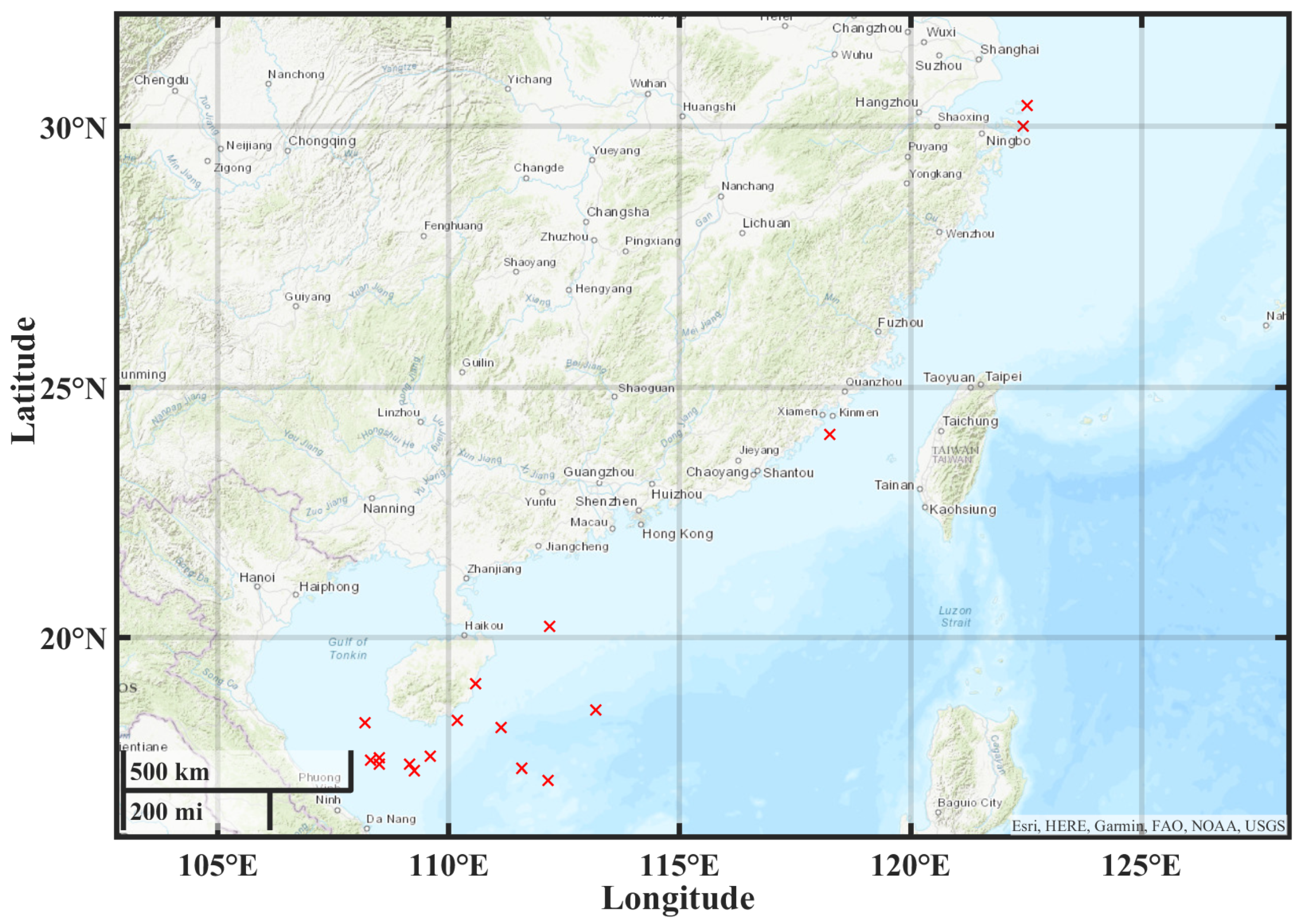
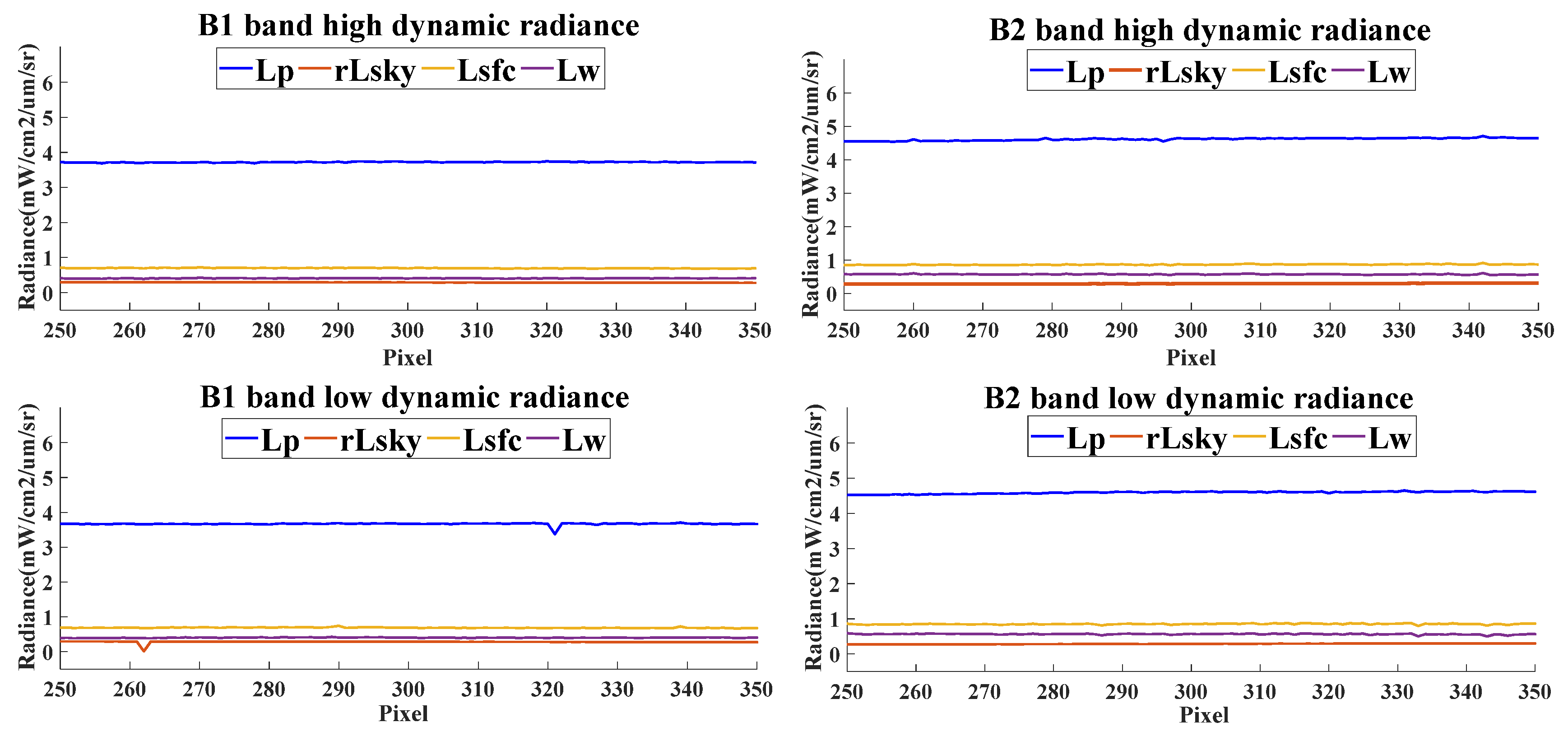
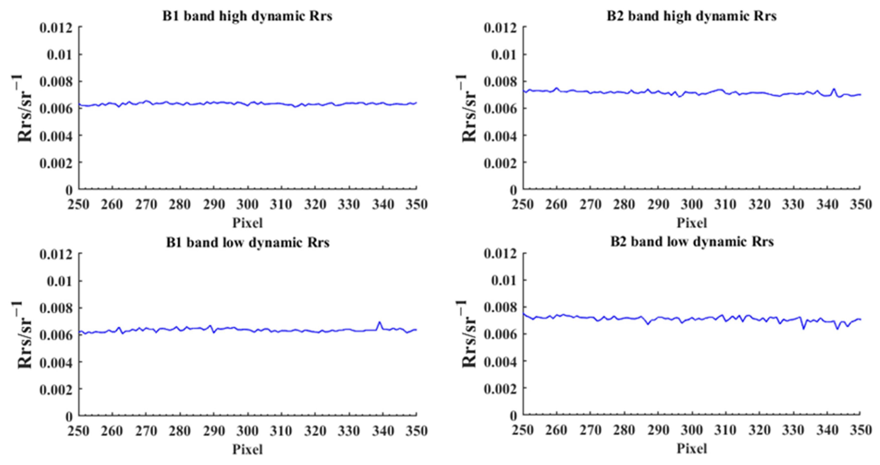
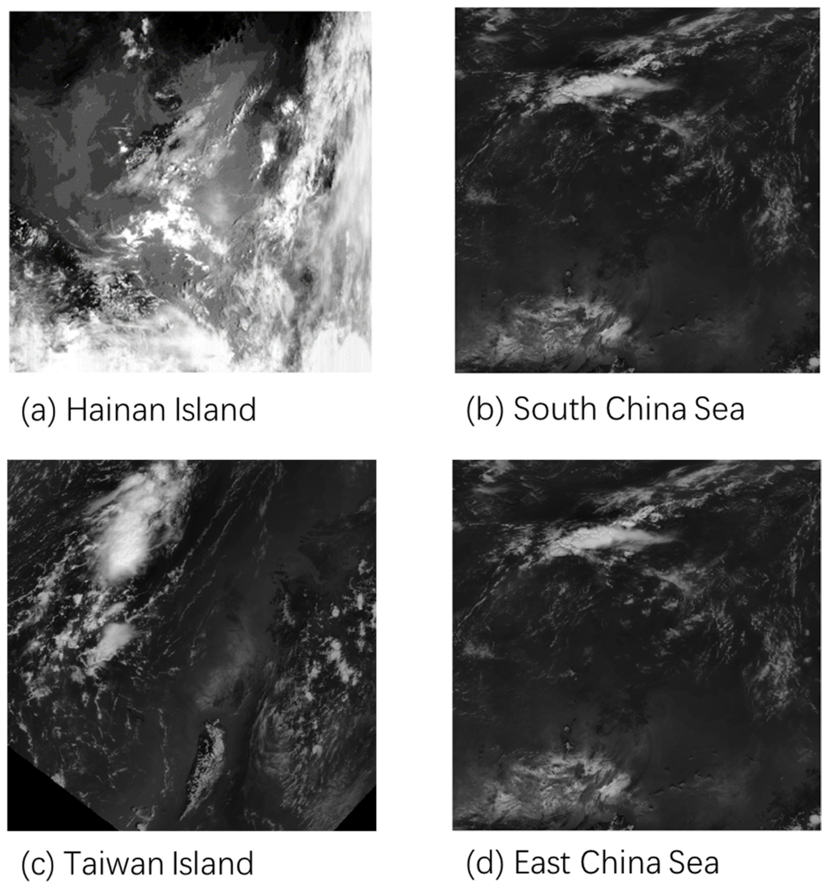
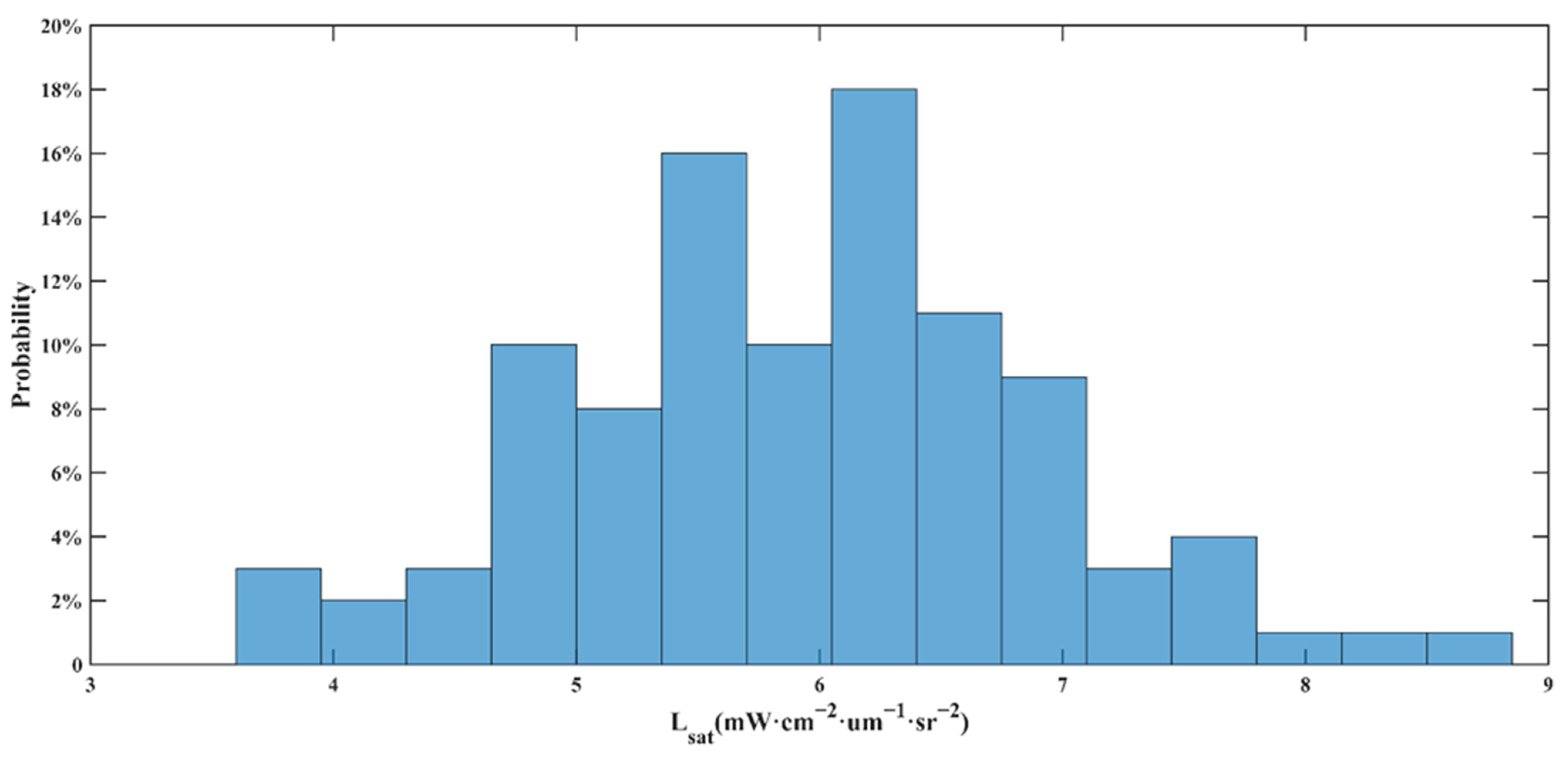
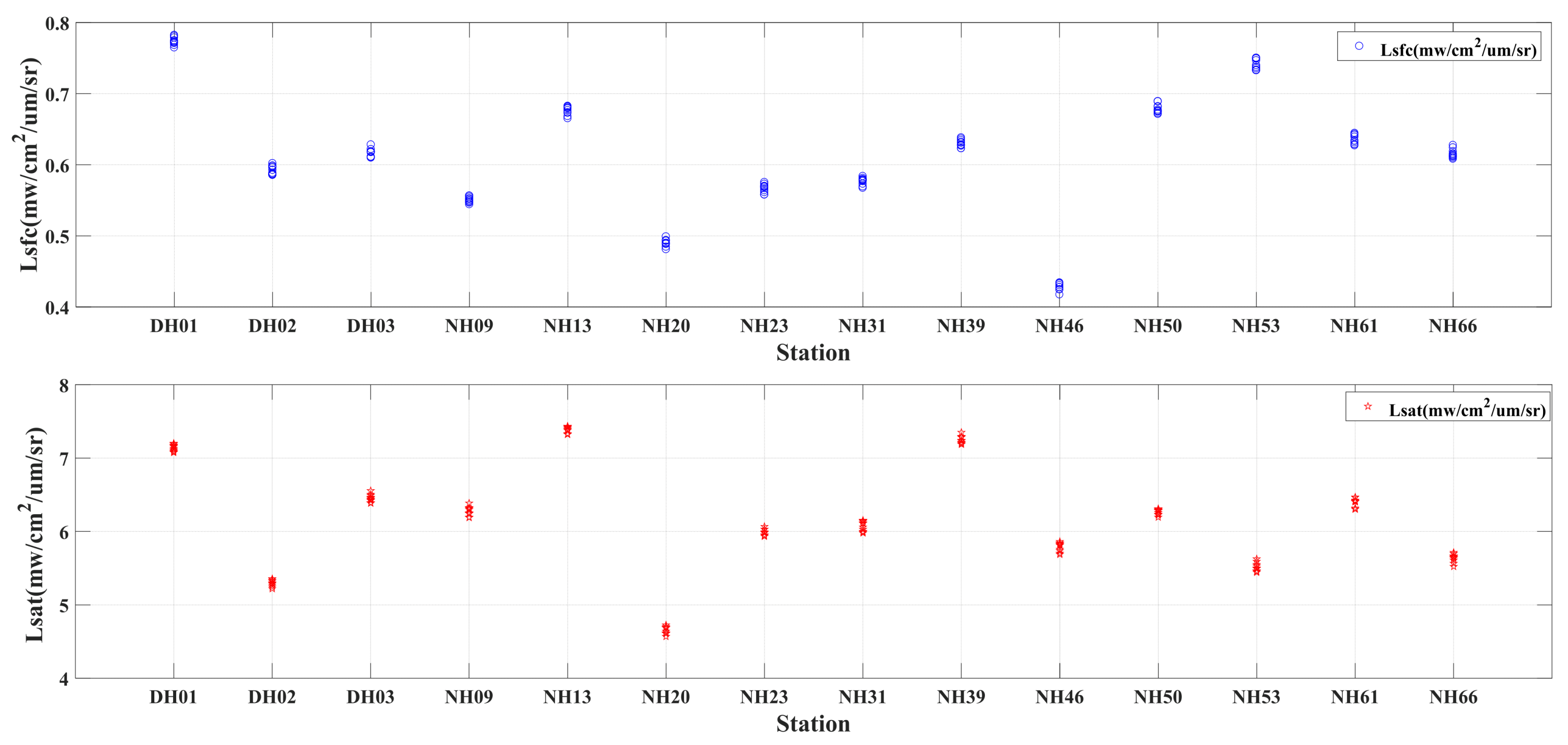
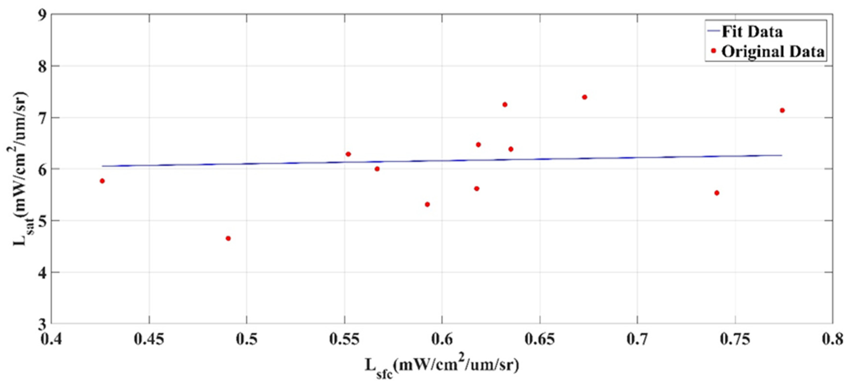
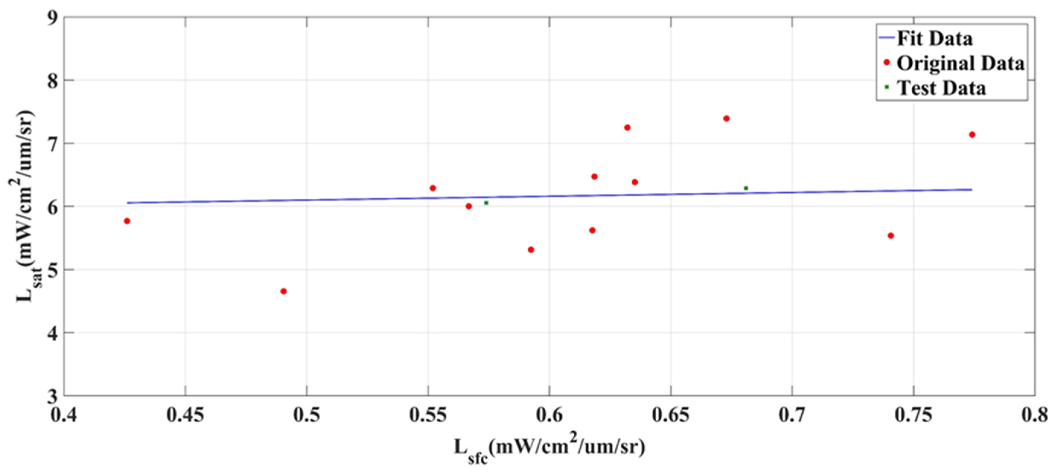
| Study Area | Geographical Location (Longitude, Latitude) | Lsfc(mW·cm−2·um−1·sr−1) | Lsky(mW·cm−2·um−1·sr−1) | ||
|---|---|---|---|---|---|
| Average Radiance | Standard Deviation | Average Radiance | Standard Deviation | ||
| DH01 | N30.40.36 E122.53.91 | 0.774 | 0.067 | 9.613 | 0.168 |
| DH02 | N24.07.60 E118.24.71 | 0.592 | 0.020 | 9.244 | 0.285 |
| DH03 | N20.22.07 E112.19.64 | 0.619 | 0.019 | 10.532 | 0.261 |
| NH09 | N19.05.92 E110.58.47 | 0.552 | 0.038 | 12.685 | 0.307 |
| NH13 | N18.51.01 E113.18.96 | 0.673 | 0.017 | 9.747 | 0.257 |
| NH20 | N18.30.37 E110.19.33 | 0.491 | 0.008 | 11.203 | 0.309 |
| NH23 | N17.08.93 E112.15.54 | 0.567 | 0.019 | 8.655 | 0.104 |
| NH31 | N17.49.63 E108.31.49 | 0.574 | 0.024 | 11.199 | 0.308 |
| NH39 | N18.26.43 E108.18.35 | 0.632 | 0.011 | 11.304 | 0.295 |
| NH46 | N17.57.27 E109.59.37 | 0.426 | 0.008 | 11.604 | 0.306 |
| NH50 | N17.27.18 E109.25.79 | 0.681 | 0.006 | 13.475 | 0.351 |
| NH53 | N17.32.77 E111.58.88 | 0.741 | 0.009 | 9.357 | 0.168 |
| NH61 | N18.16.17 E111.14.60 | 0.635 | 0.021 | 9.929 | 0.229 |
| NH66 | N17.54.06 E108.49.02 | 0.618 | 0.025 | 9.901 | 0.215 |
| RMSE | R-Squared | Pearson’s r | |
|---|---|---|---|
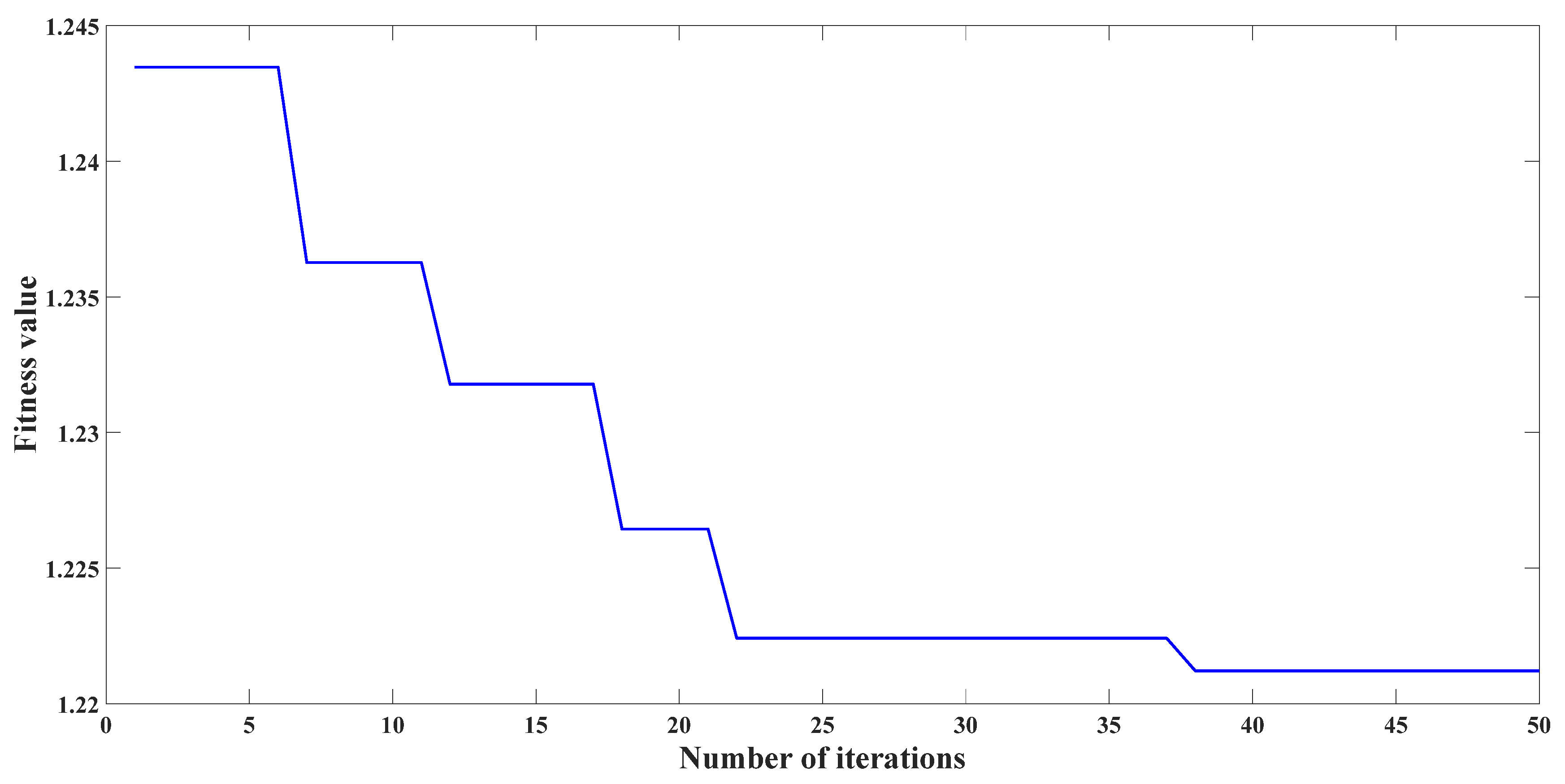
| SOA | 0.145 | 0.47 | 0.69 |
| GA | 0.227 | 0.34 | 0.58 |
| ACO | 0.186 | 0.38 | 0.62 |
| SA | 0.317 | 0.28 | 0.53 |
Disclaimer/Publisher’s Note: The statements, opinions and data contained in all publications are solely those of the individual author(s) and contributor(s) and not of MDPI and/or the editor(s). MDPI and/or the editor(s) disclaim responsibility for any injury to people or property resulting from any ideas, methods, instructions or products referred to in the content. |
© 2023 by the authors. Licensee MDPI, Basel, Switzerland. This article is an open access article distributed under the terms and conditions of the Creative Commons Attribution (CC BY) license (https://creativecommons.org/licenses/by/4.0/).
Share and Cite
Li, L.; Yin, D.; Li, Q.; Zhang, Q.; Mao, Z. An Exploratory Verification Method for Validation of Sea Surface Radiance of HY-1C Satellite UVI Payload Based on SOA Algorithm. Electronics 2023, 12, 2766. https://doi.org/10.3390/electronics12132766
Li L, Yin D, Li Q, Zhang Q, Mao Z. An Exploratory Verification Method for Validation of Sea Surface Radiance of HY-1C Satellite UVI Payload Based on SOA Algorithm. Electronics. 2023; 12(13):2766. https://doi.org/10.3390/electronics12132766
Chicago/Turabian StyleLi, Lei, Dayi Yin, Qingling Li, Quan Zhang, and Zhihua Mao. 2023. "An Exploratory Verification Method for Validation of Sea Surface Radiance of HY-1C Satellite UVI Payload Based on SOA Algorithm" Electronics 12, no. 13: 2766. https://doi.org/10.3390/electronics12132766
APA StyleLi, L., Yin, D., Li, Q., Zhang, Q., & Mao, Z. (2023). An Exploratory Verification Method for Validation of Sea Surface Radiance of HY-1C Satellite UVI Payload Based on SOA Algorithm. Electronics, 12(13), 2766. https://doi.org/10.3390/electronics12132766


