Abstract
Vehicle–road coordination is an important application scenario in the sustainable development of urban transportation. In this scenario, by navigating the vehicles in the road network, the vehicles can run more smoothly in the city, reduce unnecessary detours and parking, and realize energy savings and emission reductions. Although vehicle–road coordination in a large area has not been fully realized, people’s travel is increasingly dependent on navigation. If the trips of most vehicles follow the same navigation suggestion in a short period of time, some sections in the given route of the navigation will bear excessive traffic load. In order to solve this potential problem, this paper relies on the vehicle–road collaboration scenario and combines the service level of the road network factors between vehicles to plan the travel path of the vehicle. This keeps the traffic load of each road section in the path at a reasonable level. Within the scope, considering the overall utilization of road resources and the efficiency of road network traffic, we established the road network evaluation index through the simulation comparison with the Dijkstra algorithm. Under the path planning method proposed in this paper, the total travel time of the vehicle is reduced by 23.4%, and the road network operation efficiency is improved by 6.6%, which proves that the method can be used. This method can effectively alleviate the load of the road network, improve operation efficiency, and finally achieve the purpose of energy saving and emission reduction.
1. Introduction
The physical length or travel time of a path is not the only measure of whether it meets the global optimum. Assuming that the shortest path between two points is A, and the next shortest path is B, if most vehicles travel on path A, some sections on path A will bear excessive traffic load and cause congestion, while the traffic on that section of path B will be non-congested. The load of path B is small, the traffic flow on the road network has not reached a reasonable configuration at this time, and the traffic load has not been balanced. Under the premise of the realization of vehicle–road coordination, through the path planning of the vehicles in the road network, the purpose of rationally allocating traffic demand and balancing the load of the road network can be achieved [1,2]. Path planning usually utilizes the classical graph search algorithm to find the shortest path in the road network. In the division of planning methods, according to whether the travel time of the link changes, it can be divided into two categories: Static Path Planning (SPP) and Rolling Path Planning (RPP).
In SPP, there are many famous and mature algorithms, such as Dijkstra, A*, ant colony, and so on. These algorithms mainly study the cumulative minimum weight of the origin and destination. For example, Zhang et al. [3] improved Dijkstra’s algorithm by using a dynamic adjacent node weight matrix. Wu et al. [4] proposed an urban vehicle cooperative routing method on the Internet of Vehicles environment, which calculates the weight of each road according to the road state when the vehicle arrives at the intersection to calculate an optimal path. Li et al. [5] proposed a global optimal path planning method considering the time-varying characteristics of road network weights to solve the global optimal path. Although the current development of SPP is relatively mature, it also has certain defects, such as the high redundancy of Dijkstra’s algorithm, and the A* algorithm easily falls into the local optimal solution. Therefore, various improved versions have been derived [6,7,8], but these methods mostly focus on solving efficiency and accuracy, ignoring the combination with actual traffic factors [9]. Yuan et al. [10] formed the path planning problem as the problem of inferring a sequence of nodes in a network path and adapted a sequence-to-sequence model to learn implicit forwarding paths based on empirical network traffic data.
RPP focuses on the search performance of traffic information and algorithms. Its idea is to continuously update the route of the vehicle by repeatedly calling the path planning algorithm. For example, Chai et al. [11] proposed a dynamic path planning strategy in the adaptive signal control network; Zhao [12] continuously planned the driving route of the smart car through the big data acquisition and analysis framework in the information center network. In improving the randomness of the path search algorithm, EI-Wakee [13] proposed a dynamic route planning system based on crowd perception. Based on the variable acceleration technique for solving the shortest path problem with bounded bidirectional dynamic programming constraints, Tilk [14] introduced a dynamic halfway point to reduce the overall computational cost of solving the shortest path problem. Furthermore, Liu et al. [15] obtained the road network weights in real time and carried out dynamic path planning by finding the current node of the vehicle based on the Internet of Vehicles platform. In RPP, the actual driving route of the vehicle is formed by splicing local optimal paths planned in multiple stages, but the superposition of multiple local optima does not necessarily equal the global optimal. Zeng et al. [16] presented a spatial optimized dynamic path planning algorithm, enhancing the effect of the dynamic path planning by optimizing the search direction, and finally obtained the optimal solution in dynamic path planning, proving its feasibility and accuracy through experiments. Guo et al. [17] proposed a global path planning approach with time division-based hierarchical topology maps to achieve a legal optimal path with the consideration of complicated topology maps caused by the dynamic traffic rules in local intersections and lanes.
Most of the existing path planning research focuses on the path planning of a single vehicle [18], while the impact of path planning on the macro road network is relatively small. Although some studies consider the path planning algorithm for optimizing vehicles from the macro level [19,20], few studies start from the path planning of a single vehicle to optimize the traffic load of the entire road network. Even research on traffic evaluation indexes, such as traffic load, is lacking.
Some scholars have made some contributions to the research of traffic evaluation indexes. Floating car data (FCD) have recently become a popular tool of urban traffic engineering. Pavlyuk and Jackson [21] used FCD to estimate the speed of traffic flow and demonstrated its feasibility and accuracy. Butilă et al. [22] gave a comprehensive description of the role of unmanned aerial vehicles (UAVs) in traffic detection and analysis and pointed out that the establishment of a traffic evaluation system is still in its initial stage, but it has large development potential in the future. Aung et al. [23] designed a congestion pricing system based on the contribution of traffic congestion, which is enlightening for the evaluation of traffic states, and this evaluation system can be used in path planning.
Based on the analysis of the above problems and relying on the vehicle–road coordination system, this paper proposes a path planning method in the application scenario where vehicle–vehicle and vehicle–road information interactions have been relatively completed. Under the travel demand of High-Density Same Origin and Destination (HDSOD), most vehicles follow the same route suggested by navigation, which causes local road congestion and uneven distribution of global road resources in the road network.
2. HDSOD Path Planning Method Based on Vehicle–Road Cooperation
2.1. HDSOD Method
Denote the number of traveling vehicles between two adjacent nodes as . In this paper, the travel time under free traffic flow is used as the traffic weight between the two nodes, which is denoted as . Denote as the traffic travel amount and attraction amount of each node, then there are constraints . The HDSOD method limits the traffic volume of the corresponding link within a reasonable range by constraining the attraction of the node so that the road resources of the corresponding link are fully utilized without being congested. Additionally, the HDSOD method prioritizes meeting travel demand before considering the travel time and traffic efficiency. The objective function is as follows:
2.2. Road Network
The road network topology is shown in Figure 1.
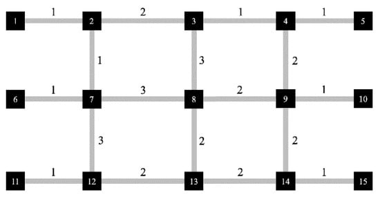
Figure 1.
Road network topology.
In order to reflect the relationship between road sections and intersections in the road network, it is necessary to delineate the demarcation line between them. As shown in Figure 2 below, the node (or the intersection) is where the vehicle cannot change its lane, and the road section between the two nodes is a link.

Figure 2.
Classification of road sections and intersections.
The steering of the vehicle needs to be considered in the description of the road network, and it is difficult to accurately represent the specific flow direction of vehicles by a simple two-dimensional matrix. In this paper, the road network is described as follows: each original node has its corresponding upstream and downstream nodes, indicating that the vehicle is driving from an upstream node to a downstream node through this original node. In the physical area through the original node, there will be a certain loss of time—the loss of time corresponds to the weight of straight, left, and right turns. If it corresponds to an impassable road or direction, we use ∞ to fill the cells in Table 1.

Table 1.
Road network storage data structure.
2.3. Path Planning Scenario under Vehicle–Road Cooperative Conditions
The research carried out in this paper is based on the realization of the vehicle–road coordination system, and information such as the position and speed of the vehicle can be obtained. Each link should have its capacity to accommodate vehicles at congestion density, and this paper sets a threshold for this capacity. When planning the path for travel demand, the traffic load of each link in the path and the interaction between different vehicles is integrated to estimate the arrival time when the vehicle is expected to arrive at each link in the to-be-determined path. If the traffic load on a certain link at this moment is higher than the threshold when the vehicle arrives at the link, the link will not participate in this path planning, and the next-optimal path will be selected among the alternative paths, and the above judgment will be made again. If the conditions are met, the path will be the travel path.
In path planning, vehicles and the roadside unit on the node communicate with each other and transfer their data. By a comprehensive comparison of the traffic load of each link in the path, the final path will be obtained. In the process of vehicle travel, there will no longer be dynamic planning of the path for this travel demand. The HDSOD path planning method flow chart is shown in Figure 3.
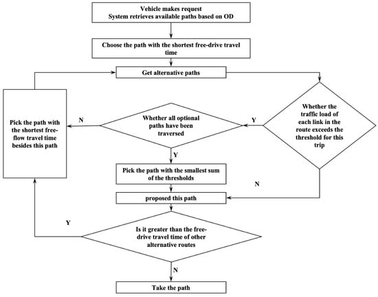
Figure 3.
Flow chart of HDSOD planning method.
The main variables used in this paper and their descriptions are listed in Table 2.

Table 2.
Variables used in this paper and their descriptions.
3. Traffic Evaluation Indicators
3.1. Traffic Load Evaluation Index
The impact of safety risk factors on travel should be considered when making path planning [24]. The greater the number of vehicles in the certain link , the greater the traffic load to the road network, and the greater the possibility of traffic accidents . In addition, there are certain traffic travels and attractions in the actual traffic conditions, which will also have an impact on the existing traffic flow. Therefore, the growth rate of the traffic load should increase with the increase of , and make the curve overflow faster. The relationship between and is shown in Figure 4.
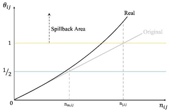
Figure 4.
relationship diagram.
In the evaluation index of this paper, is the traffic load threshold of the link between two nodes. If , then each vehicle enters the link after that, the impact of the vehicle on the link will add a penalty. The factor means that each vehicle will have a negative gain in the service level of the road. Its values are as follows:
In summary, traffic load on the is:
3.2. Traffic Status Evaluation Index
Figure 5a shows the relationship between traffic flow rate and traffic density, and Figure 5b shows the relationship between the speed of vehicles and traffic density. When the density on the , traffic operation is in a state of congestion. The flow in this state is , corresponding to the existence of a non-congested state when the traffic is shown as follows, so the traffic state cannot be judged by the flow rate alone.
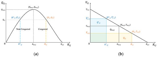
Figure 5.
(a) Relationship between traffic flow rate and traffic density. (b) Relationship between the speed of vehicles and traffic density.
In this paper, two indexes, dynamic and static, are used to evaluate the traffic operation status.
Denoting the static evaluation index as , which is composed of two parts, one is the ratio of the average spatial speed of the current roadway to the speed of smooth traffic. Another part is the ratio of the density margin of the current roadway to the density of congestion, which is used to evaluate the capacity of the current roadway. The value of could be calculated as follows:
Denoting the dynamic evaluation index as , which is the absolute difference between the current flow rate of the road section and the best flow rate. This index is used to evaluate the current traffic efficiency of a certain link. It could be calculated as follows:
The static and dynamic indexes of the whole road network are denoted as , and there are . Similarly, the static and dynamic evaluation indexes of each link are denoted as , which could be set as .
4. Traffic Scenario Analysis under HDSOD Method
4.1. Traffic Load Threshold
Set the maximum number of vehicles that can pass in a valid green light time. If, at a certain period, when the green light is on, and there are vehicles queueing behind the stop line, these vehicles can pass through the intersection during the green light time, which is shown in Figure 6.

Figure 6.
Vehicle crossing intersection at saturation headway.
However, when the vehicles arrive at the intersection in a discrete form and participate in the queue, the last of vehicles cannot cross the intersection and must wait in the queue during this cycle. Moreover, they can pass normally during the green light time of the next cycle; this scene is shown in Figure 7.
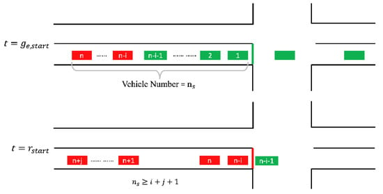
Figure 7.
Discrete vehicle formation cannot fully pass the intersection to form a queue.
If subsequent vehicles arrive at the intersection, one after another, then they will join the queue. For the queue of these vehicles to pass the intersection in the next cycle, the number of vehicles needs to satisfy the condition that . We set the length of the space occupied by a vehicle on the roadway as , then the traffic load threshold can be calculated as:
4.2. Vehicle Access Conditions under the Critical Threshold
When the number of vehicles in the link reaches , in order not to impose a greater traffic load on this link, subsequent vehicles should be restricted from entering the link. However, the traffic flow is dynamically changing and interacting with each other, and the operation of the traffic flow should not be constrained simply from a single variable of . Denoting the time when the red light is turned on as the starting point of the cycle, then there is . If the vehicle starts from the upstream original point of its link to the end of the queue with vehicles ahead, the travel time could be denoted as: .
Denoting the time when a certain vehicle enters and leaves a certain link as , we record the time when the vehicle reaches the end of the queue as . A certain headway increment is in the queue, and the saturated headway is , then the average headway is , which can be calculated as: .
Now we can discuss the corresponding constraints when a vehicle passes through the intersection in different scenarios. To ensure that multiple times of queuing do not occur, should be satisfied.
- (1)
- is within the valid green light time, and the traffic flow on the link at this moment has reached the saturation flow rate, the vehicle does not stop nor slow down to pass the intersection (Figure 8).
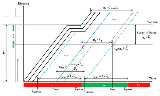 Figure 8. Space–time diagram of scenario (1).
At the moment , the vehicle joins the vehicle formation ahead, passing through the intersection with a saturated flow rate and passes through the intersection. Currently, the vehicle maintains a saturated headway with the last vehicle of the formation. When satisfies the following constraints, the vehicle can pass through the intersection normally without decelerating:
and .
- (2)
- When the is in the range of valid green time, a certain part of the traffic flow on the link has not reached the saturation flow, the vehicle needs to slow down or even stop for a while, then passes through the intersection in the current cycle (Figure 9).
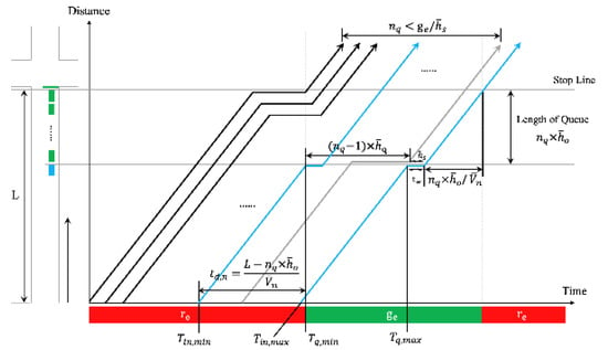 Figure 9. Space–time diagram of scenario (2).
Compared with scenario (1), this scenario needs to consider the dissipation time of the queued vehicles ahead. Assuming that the reaction time of a vehicle from the time it observes the start of the preceding vehicle to its own start is , when satisfy the following constraints, the vehicle can smoothly pass through the intersection in the current cycle:
And .
- (3)
- are both in the range of valid red time, the vehicle needs to queue once before passing the intersection, which scenario is shown as Figure 10:
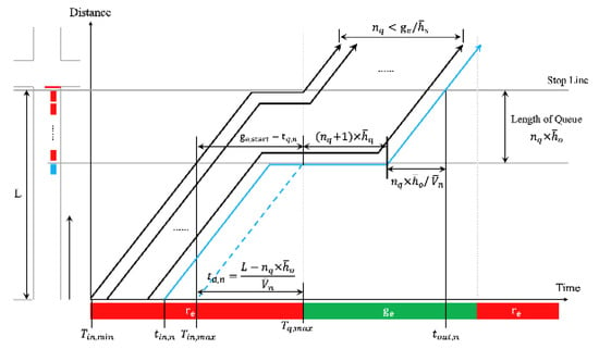 Figure 10. Space–time diagram of scenario (3).
When the vehicle reaches the end of the queue and is still within the red time, it needs to stop and wait for the green light to end. When satisfy the following constraints, the vehicle can pass the intersection smoothly in the current cycle:
and .
- (4)
- is in the range of valid green time, but the vehicle fails to pass the intersection in this period, as shown in Figure 11.
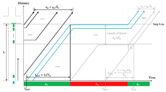 Figure 11. Space–time diagram of scenario (4).
If the vehicle reaches the end of the queue within the valid green time but fails to pass the stop line, at least one vehicle queuing is required. This scenario forms a closed loop with the above three scenarios, and these vehicles intercepted by the red light become vehicles that arrive in front of the vehicle in the next cycle. The of these vehicles satisfy the following equations:
and .
To sum up, when planning the path, the traffic load should be calculated by accumulating the number of vehicles on the corresponding link in each future cycle according to the estimated time of each vehicle, and then determine whether the link could be selected in the path planning according to of the , of the vehicle. Denoting the number of vehicles that have passed the stop line when the vehicle enters the link as . According to the definition of the scene and the control objective, there is , and we denote the number of vehicles arriving after a certain vehicle as . According to in different situations at , the conditions for allowing the link to be selected in the path planning are as follows:
- (1)
- When :or
- (2)
- When :In the above formula .
4.3. Pass Time Verification
In the above, a path is obtained based on the principle of the shortest free flow time and combining the traffic load threshold situation on each link. Let the yellow path 7-8-9 be derived from the above method, but there is also a longer trip blue path 7-2-3-4-9. The two paths are shown in Figure 12, assuming that the traffic load threshold will not be exceeded by the vehicles passing through the corresponding link.
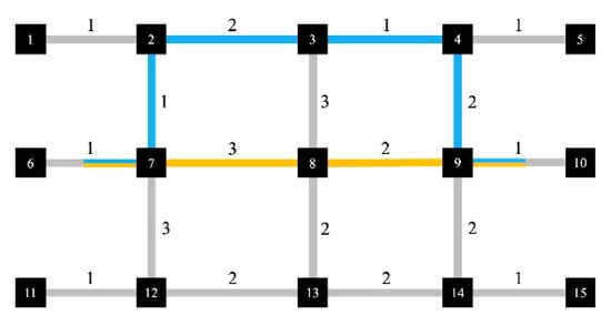
Figure 12.
Schematic diagram of the travel path.
As shown in Figure 13, among the two paths given above, due to the influence of the signal lights, the actual travel time of the path 7-2-3-4-9 with a theoretically longer travel time in the free flow state is shorter instead. Therefore, it is necessary to check whether the travel time of a path is better than the others.
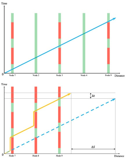
Figure 13.
Comparison of passage time of different paths.
After the path obtained by considering the comprehensive traffic load above, the estimated travel time to the destination can be calculated as:
Among the formula above, is the time taken by the vehicle from the travel original point upstream of the first node of the obtained path to the time it passes the stop line of the node. Its value refers to the calculation of in the previous section. is the time it takes for the vehicle to leave the last node in the obtained path and reach the travel destination with a downstream distance of , and there is . is the time it takes for the vehicle to pass through the physical area of the intersection.
When there are no other vehicles on a certain path, and the vehicles pass through each intersection in the path in the form of free flow, the minimum value of the estimated travel time of this path can be calculated. When checking the travel time, the paths which satisfy should be selected, and then the estimated travel time corresponding to these paths with reference to the above calculation could be calculated. Finally, the corresponding path of is the planned path of HDSOD.
5. Simulation
5.1. Design of the Simulation
In this paper, both the shortest path derived from Dijkstra’s algorithm and the path derived from the HDSOD algorithm are simulated with the same parameters for comparison. The simulations are performed every certain period, with length , randomly generated travel demand at each node, and the total traffic load of the road network of the two algorithms, and , evaluated at every minute.
5.2. Results
The left-hand of Figure 14 reflects the time-varying situation of the number of vehicles in the road network and the right-hand of it reflects how many vehicles are in the network by HDSOD less than Dijkstra, the blue line is the value, and the black line is the baseline (the value is 0 when the vehicle number in the network is equal by HDSOD and Dijkstra). In the initial stage of the simulation, the number of vehicles on the road is not sufficient to exceed the traffic load threshold, the vehicles travel on the paths planned by Dijkstra’s algorithm, and the number of vehicles in the network is very approximate. For a short period of time afterward, the HDSOD effect is lower than Dijkstra. The reason is that after the traffic load at some nodes reaches the threshold, the algorithm determines that these nodes are no longer suitable for inclusion in the path planning and gives another suboptimal path in terms of travel time, resulting in a higher number of vehicles under the HDSOD method at the same time. As subsequent vehicle inputs increase, vehicles using Dijkstra’s algorithm to plan paths cause more severe delays because they are silted up on specific roads, causing their traffic load to exceed the threshold. The HDSOD method, on the other hand, balances the traffic load on each link and trades the passing time for pass efficiency, allowing vehicles to exit the road network more efficiently.

Figure 14.
Comparison of the number of vehicles in the road network.
The left side of Figure 15 reflects the static indicators of the road network of the time-varying situation, and the right-hand of it reflects how much better the utilization of the road network is by HDSOD than by Dijkstra, the blue line is the value, and the black line is the baseline (the value is 0 when the utilization of road network is equal by HDSOD and Dijkstra). From Figure 15, the remaining road capacity under the HDOSD is lower than Dijkstra during the time period when vehicle inputs are available, indicating that more vehicles are allocated to the network in a balanced manner, and the road network resources are better utilized. The figure reflects that the road resource utilization of HDSOD is better compared to Dijkstra most of the time, with a maximum improvement of 6.6%. At the end of the simulation, because the vehicles in HDSOD are close to evacuation, the space occupancy of vehicles on the road network is low, and the road network resource utilization is not high, and its evaluation is lower than Dijkstra.

Figure 15.
Comparison of the utilization rate of road network resources.
The left side of Figure 16 reflects the dynamic indicators of the road network of the time-varying situation. The right-hand of it reflects how much better the operation of the road network is by HDSOD than by Dijkstra; the blue line is the value, and the black line is the baseline (the value is 0 when the operation effective of the road network is equal to HDSOD and Dijkstra). When the HDSOD method assigns vehicles to different road sections, the overall congestion of the road network under this method is relatively lighter, and the flow is closer to the optimal flow, so the absolute difference between the flow under the HDSOD method and the optimal flow is smaller, and the operational efficiency of the road network is higher than that of Dijkstra.

Figure 16.
Comparison of road network traffic efficiency.
The left side of Figure 17 reflects the time-varying total travel time of vehicles in the road network and the right side of it reflects the percentage reduction of HDSOD over Dijkstra; the blue line is the percentage, and the black line is the baseline. For a period after the start of the simulation, HDSOD plans the shortest non-trip time path for vehicles for the sake of balancing the traffic load when Dijkstra’s trip time is 8.4% less than HDSOD. However, when the number of vehicles gradually increases, Dijkstra’s algorithm still directs the vehicles to a specific path to overload the traffic and increase the delay. In contrast, HDSOD allows vehicles to avoid congested roadways, resulting in less total travel time and a reduction of about 23.4% in total travel time within one hour of the simulation time.

Figure 17.
Total travel time comparison.
6. Conclusions and Discussion
This paper proposes an HDSOD path planning method, which aims to improve the overall utilization of road resources in the road network while considering the operational efficiency of traffic flow, ultimately reducing carbon emissions and vehicle travel time, as well as meeting more traffic demands simultaneously.
With the growing popularity of Road Side Units (RSU), On Board Units (OBU), and other advanced devices in recent years, most of the implementation conditions of vehicle–road cooperation scenarios have been met. The research on the application in this scenario should also be accelerated to improve people’s comfort and convenience [25]. This method provides some implications for the study of vehicle–road collaboration application scenarios. The method proposed in this paper relies on the vehicle–road cooperation scenario and can obtain the required vehicle travel data and location information. The travel path is planned according to the vehicle travel demand so that the traffic volume of each road section in the path is kept within a reasonable range so that the road resources of the corresponding road section are fully utilized but not congested.
Combining the parameter requirements of the path planning method proposed in this paper, this paper also establishes the service level evaluation index by combining the relationship between the three parameters of traffic flow. This evaluation index can better evaluate the operational efficiency of the road network under the vehicle–road cooperation scenario and can be used as a basis for systematic route planning for each travel demand. Based on the evaluation index and compared with the Dijkstra method through simulation, it is verified that the performance of the method proposed in this paper is not much different from that of the conventional route planning method when the travel demand is low, but when the travel demand is high, the road resource utilization, vehicle traffic efficiency, total travel time of the road network, and carbon emissions are optimized to some extent. This illustrates the effectiveness of the HDSOD method in preventing traffic congestion and alleviating travel delays under high travel demand compared to traditional route planning methods.
The algorithm proposed in this paper belongs to the SPP static path planning approach, which starts from a macro perspective when responding to travel demand and aims to balance the traffic flow of the whole road network, integrating road capacity, road traffic load, regional OD travel, traffic accidents, and other factors for path planning. However, it is also a dynamic algorithm due to the dynamic traffic status and parameters. Because the impact of the path on the road traffic load of the vehicles at a specific time is considered at the beginning of the path planning, the travel path is not adjusted dynamically once it is determined, which avoids the influence of dynamic variables on the complexity of the algorithm and is more advantageous in terms of time complexity than the traditional RPP planning method. However, due to the limitations of SPP itself, although this paper considers the impact of traffic accidents and other causes on the operation of the road network based on statistical probability, there will always be some deviation from reality. In practical applications, if unexpected events occur, such as traffic accidents or unpredictable driver behavior, it may lead to the inability to achieve the theoretical optimal results. Besides SPP and RPP, multi-agent path planning (MAPP) is also increasingly being used to address resource allocation problems in highly dynamic, distributed environments that involve autonomous agents. Shi et al. [26] introduced a more general class of MAPP problems—MAPP in a soft-collision context; this method also shows some temporal advantage in path planning. This is one of the subsequent directions to be drawn from this topic.
Therefore, further refinement of the statistical probability model, including driver obedience rate, may be required in future research to increase the robustness of the HDSOD method. The HDOSD method also has some significance for future research on the sustainable development of urban transportation [27]. Therefore, the inclusion of carbon emission indicators in the evaluation system is also part of the future work of this paper.
Author Contributions
Writing-original draft preparation, B.H.; methodology, F.Z.; writing-review and editing, L.L. All authors have read and agreed to the published version of the manuscript.
Funding
This research received no external funding.
Institutional Review Board Statement
Not applicable.
Informed Consent Statement
Not applicable.
Data Availability Statement
The data presented in this study are available on request from the authors.
Conflicts of Interest
The authors declare no conflict of interest.
References
- Wang, Y.; Zhao, J.; Li, X.; He, H. Review of Vehicle Route Planning Based on Traffic Big Data. Softw. Guide 2020, 19, 50–54. [Google Scholar]
- Mauve, M.; Widmer, J.; Hartenstein, H. A Survey on Position-Based Routing in Mobile Ad Hoc Networks. IEEE Netw. 2001, 15, 30. [Google Scholar] [CrossRef]
- Zhang, L.; Pan, F.; Zou, X.; Wang, F. Study and realization of Vehicle Guidance System based on GIS and GPS. In Proceedings of the 2008 IEEE International Conference on Service Operations and Logistics, and Informatics, Beijing, China, 12–15 October 2008. [Google Scholar]
- Wu, L.; Fan, J.; Nie, L.; Cui, J.Q.; Zou, Y.F. A Collaborative Routing Method with Internet of Vehicles for City Car. Chin. J. Comput. 2017, 40, 1600–1613. [Google Scholar]
- Li, W.; Hu, M.; Chen, L.; Rao, K. Global Optimal Path Planning Considering Time-Varying Weight of Road Network. J. Chongqing Univ. 2021, 44, 31–42. [Google Scholar]
- Liang, B.; Yang, X. Study on Path Planning Method Based on the Improved Dijkstra Algorithm. Informatiz. Res. 2020, 46, 13–16. [Google Scholar]
- Bao, P. A Optimization Algorithm Based on Dijkstra’s Algorithm in Search of Shortcut. J. Comput. Res. Dev. 2001, 38, 307–311. [Google Scholar]
- Wang, Y.; Ren, Y.; Xia, L. Index of Binary Heap for Transportation Network and Optimization of Shortest Path Algorithms. J. Appl. Sci. 2020, 38, 117–127. [Google Scholar]
- Wang, C.; Pan, J.S.; Xu, H.R.; Jia, J.; Meng, Z.-Y. An Improved A* Algorithm for Traffic Navigation in Real-Time Environment. Third International Conference on Robot. In Proceedings of the 2015 Third International Conference on Robot, Vision and Signal Processing (RVSP), Kaohsiung, Taiwan, 18–20 November 2016. [Google Scholar]
- Zuo, Y.; Wu, Y.; Min, G.; Cui, L. Learning-based Network Path Planning for Traffic Engineering. Future Gener. Comput. Syst. 2019, 92, 59–67. [Google Scholar] [CrossRef]
- Chai, H.; Zhang, H.M.; Ghosal, D.; Chuah, C.-N. Dynamic traffic routing in a network with adaptive signal control. Transp. Res. Part C 2017, 85, 64–85. [Google Scholar] [CrossRef]
- Zhao, C.C.; Dong, M.X.; Ota, K.; Li, J.; Wu, J. Edge-MapReduce-based intelligent information-centric IoV: Cognitive route planning. IEEE Access 2019, 7, 50549–50560. [Google Scholar] [CrossRef]
- El-Wakeel, A.S.; Noureldin, A.; Hassanein, H.S.; Zorba, N. iDriveSense: Dynamic route planning involving roads quality information. In Proceedings of the 2018 IEEE Global Communications Conference (GLOBECOM), Abu Dhabi, United Arab Emirates, 9–13 December 2018; pp. 1–6. [Google Scholar]
- Tilk, C.; Rothenbacher, A.K.; Gschwind, T.; Irnich, S. asymmetry matters: Dynamic half-way points in bidirectional labeling for solving shortest path problems with resource constraints faster. Eur. J. Oper. Res. 2017, 261, 530–539. [Google Scholar] [CrossRef]
- Liu, L.; Li, C.; Chen, Y.; Feng, H.; Hua, Z. Research on Path Planning Model of Optimal Fuel Con mption Based on Routing Nodes. J. Chongqing Univ. 2018, 41, 73–81. [Google Scholar]
- Zeng, M.; Yang, X.; Wang, M.; Xu, B. Application of Angle Related Cost Function Optimization for Dynamic Path Planning Algorithm. Algorithms 2018, 11, 127. [Google Scholar] [CrossRef]
- Guo, L.; Yang, M.; Lu, Z.; Wang, B.; Wang, C. Global and Local Path Planning of MicroIV for Traffic Flow Modeling and Simulation. IFAC Proc. Vol. 2013, 46, 502–507. [Google Scholar] [CrossRef]
- Xing, T.; Zhou, X. Finding the most reliable path with and without link travel time correlation: A Lagrangian substitution based approach. Transp. Res. Part B Methodol. 2011, 45, 1660–1679. [Google Scholar] [CrossRef]
- Lu, H.; Wang, J.; Zhang, Y. Models and Application of Transport Accessibility in Urban Transport Planning. J. Tsinghua Univ. 2009, 6, 781–785. [Google Scholar]
- Chang, M.; Yuan, L.; Ding, Z.; Li, L. Adaptive Dynamic Path Planning Method Under Traffic Condition Awareness. J. Transp. Syst. Eng. Inf. Technol. 2021, 21, 156–162+247. [Google Scholar]
- Pavlyuk, D.; Jackson, I. Potential of vision-enhanced floating car data for urban traffic estimation. Transp. Res. Procedia 2022, 62, 366–373. [Google Scholar] [CrossRef]
- Butilă, E.V.; Boboc, R.G. Urban Traffic Monitoring and Analysis Using Unmanned Aerial Vehicles (UAVs): A Systematic Literature Review. Remote Sens. 2022, 14, 620. [Google Scholar] [CrossRef]
- Aung, N.; Zhang, W.; Dhelim, S.; Ai, Y. T-Coin: Dynamic Traffic Congestion Pricing System for the Internet of Vehicles in Smart Cities. Information 2020, 11, 149. [Google Scholar] [CrossRef]
- Yang, Z.; Hu, Y.; Zhang, Y. Path-Planning Strategy for Lane Changing Based on Adaptive-Grid Risk-Fields of Autonomous Vehicles. World Electr. Veh. J. 2022, 13, 175. [Google Scholar] [CrossRef]
- Yang, W.; Wang, H.; Wang, Z.; Fu, X.; Ma, P.; Deng, Z.; Yang, Z. Optimization Strategy of Electric Vehicles Charging Path Based on “Traffic-Price-Distribution” Mode. Energies 2020, 13, 3208. [Google Scholar] [CrossRef]
- Shi, R.; Steenkiste, P.; Veloso, M.M. SC-M*: A Multi-Agent Path Planning Algorithm with Soft-Collision Constraint on Allocation of Common Resources. Appl. Sci. 2019, 9, 4037. [Google Scholar] [CrossRef]
- Ren, L.; An, F.; Su, M.; Liu, J. Exposure Assessment of Traffic-Related Air Pollution Based on CFD and BP Neural Network and Artificial Intelligence Prediction of Optimal Route in an Urban Area. Buildings 2022, 12, 1227. [Google Scholar] [CrossRef]
Publisher’s Note: MDPI stays neutral with regard to jurisdictional claims in published maps and institutional affiliations. |
© 2022 by the authors. Licensee MDPI, Basel, Switzerland. This article is an open access article distributed under the terms and conditions of the Creative Commons Attribution (CC BY) license (https://creativecommons.org/licenses/by/4.0/).