Article

New Evidence of the Bangestan Geoheritage Resource in Iran: Beyond Hydrocarbon Reserves

by
Tatyana K. Molchanova
1 and
Dmitry A. Ruban
2,*
1
Department of Business in Hospitality Sphere, Higher School of Business, Southern Federal University, 23-ja linija Street 43, Rostov-on-Don 344019, Russia
2
Department of Economics and Management, Business School, Cherepovets State University, Sovetskiy Avenue 10, Cherepovets, Vologda Region 162600, Russia
*
Author to whom correspondence should be addressed.
Resources 2019, 8(1), 35; https://doi.org/10.3390/resources8010035
Submission received: 27 December 2018 / Revised: 26 January 2019 / Accepted: 11 February 2019 / Published: 12 February 2019

Abstract

:
Iran boasts internationally important deposits of hydrocarbons. The hydrocarbons can be regarded not only as an exceptional energy resource, but also a geological heritage (geoheritage) resource. A new investigation of the Bangestan carbonate rocks from the Cretaceous age in the Fars Province has permitted to find several unique features and to assign these to six geoheritage types, namely sedimentary, palaeontological, stratigraphical, palaeogeographical, structural, and economic. The most important from these is the economic type that is ranked nationally. The Bangestan geoheritage is valuable for geoscience research, geoeducation, and geotourism, and this geoheritage is a subject of geoconservation. As these activities can bring some socio-economic benefits, this geoheritage has to be considered a true natural resource. Field studies have permitted to emphasize its appropriate manifestation in the Nowdan anticline (an area in the Zagros Mountains near the cities of Shiraz and Kazeroon), which is suggested as a geosite. Hydrocarbon-related industrial tourism and geotourism activities can be coupled for their mutual benefit. The Nowdan anticline geosite should be used for the purposes of tourism, but it requires some simple infrastructure building and involvement in excursion programs coordinated by a local museum or visitor centre.

1. Introduction

Hydrocarbons remain among the most valuable natural resources for modern society. Oil and gas production in countries rich in these resources plays an outstanding role in the world economy. A typical example is Iran boasting its significant hydrocarbon potential and producing 3600–3800 tbd of crude oil in 2018, making it one of the top oil producers [1]. However, another dimension of energy resources in the oil and gas industry has recently been realized. The rising initiatives and research in geological heritage conservation (geoconservation) [2,3] and geotourism [4] since the beginning of the 21st century have posed questions about the consideration of hydrocarbon-related geological objects and the related industrial infrastructure, as a kind of new resource. This resource is especially important when hydrocarbon reserves become depleted, or when there is a necessity to decrease the dependence of the national economy on the oil and gas export. The relevant ideas were presented by Bahrainy and Jahani Moghadam [5], dos Reis and Henriques [6], Habibi and Ruban [7], Klamar et al. [8], Kruczek and Kruczek [9], Luud et al. [10], Metsaots et al. [11,12], Price and Ronck [13], Raukas and Tavast [14], Searle [15], and Sepp and Roose [16]. In sum, there are three main lines of evidence. First, hydrocarbon-related objects may be unique enough to be judged as geological heritage (geoheritage). Although aesthetic and some other auxiliary criteria can be involved for such judgments, it appears that uniqueness is the most important criterion. Second, these objects facilitate and diversify regional/local tourism development together with oil and gas extraction and after desiccation of their reserves. Third, these objects are useful for training oil and gas geologists and engineers. It should be added that the use of these objects for the purposes of geoconservation and geotourism improves the national/regional image and contributes to the sustainable development.
The entire geoheritage is an important, socially- and economically-valuable resource [17,18,19,20,21]. This is linked to its utility to natural heritage conservation, scientific research, geoscience education, and nature-based tourism development. Despite the availability of the conceptual basis and some case studies of hydrocarbon-related geoheritage resources (see above), the relevant knowledge remains limited, and deserves significant extension. The most important are identification and characteristics of this kind of resource, in particular oil- and gas-rich regions, as well as finding proper approaches for this resource exploitation. The objective of this paper is to provide the new evidence of the hydrocarbon-related geoheritage from southwest Iran, where the oil-reservoir rocks of the Bangestan Group are exposed in the Zagros Mountains. This study follows, although not replicates, the recent works of Habibi and Ruban [7], Habibi et al. [22], Maghsoudi and Rahmati [23], and Pourahmad et al. [24] and is aimed at the multi-aspect description and effective promotion of the Iranian geoheritage, urgent tasks because of the still insufficient development of geoconservation and geotourism in the Middle East. Linking new geoheritage objects to the well-known hydrocarbon reserves seems to be an efficient approach to sustain the growth of the noted activities in Iran and also to facilitate sustainable development in the southwestern part of the country.

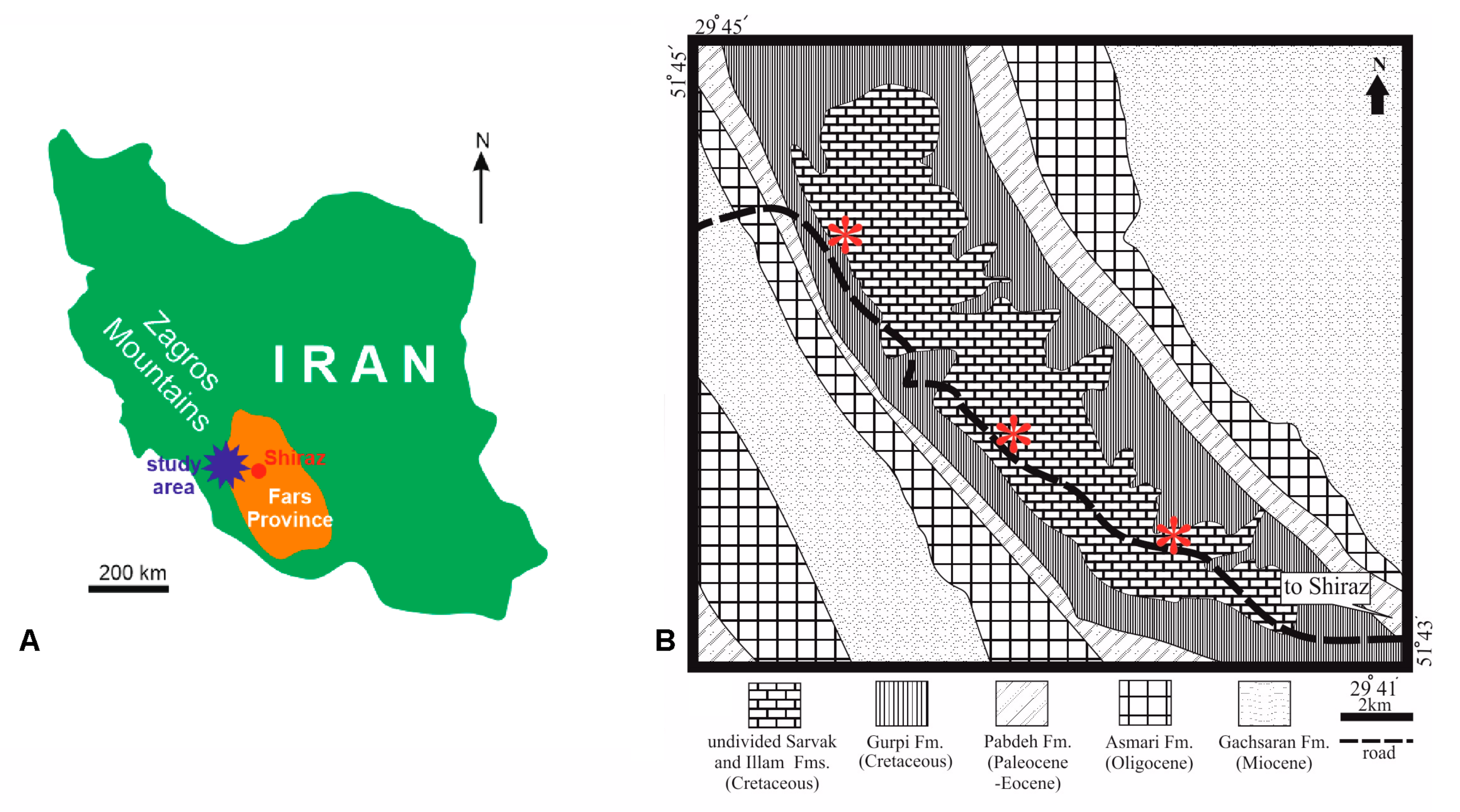
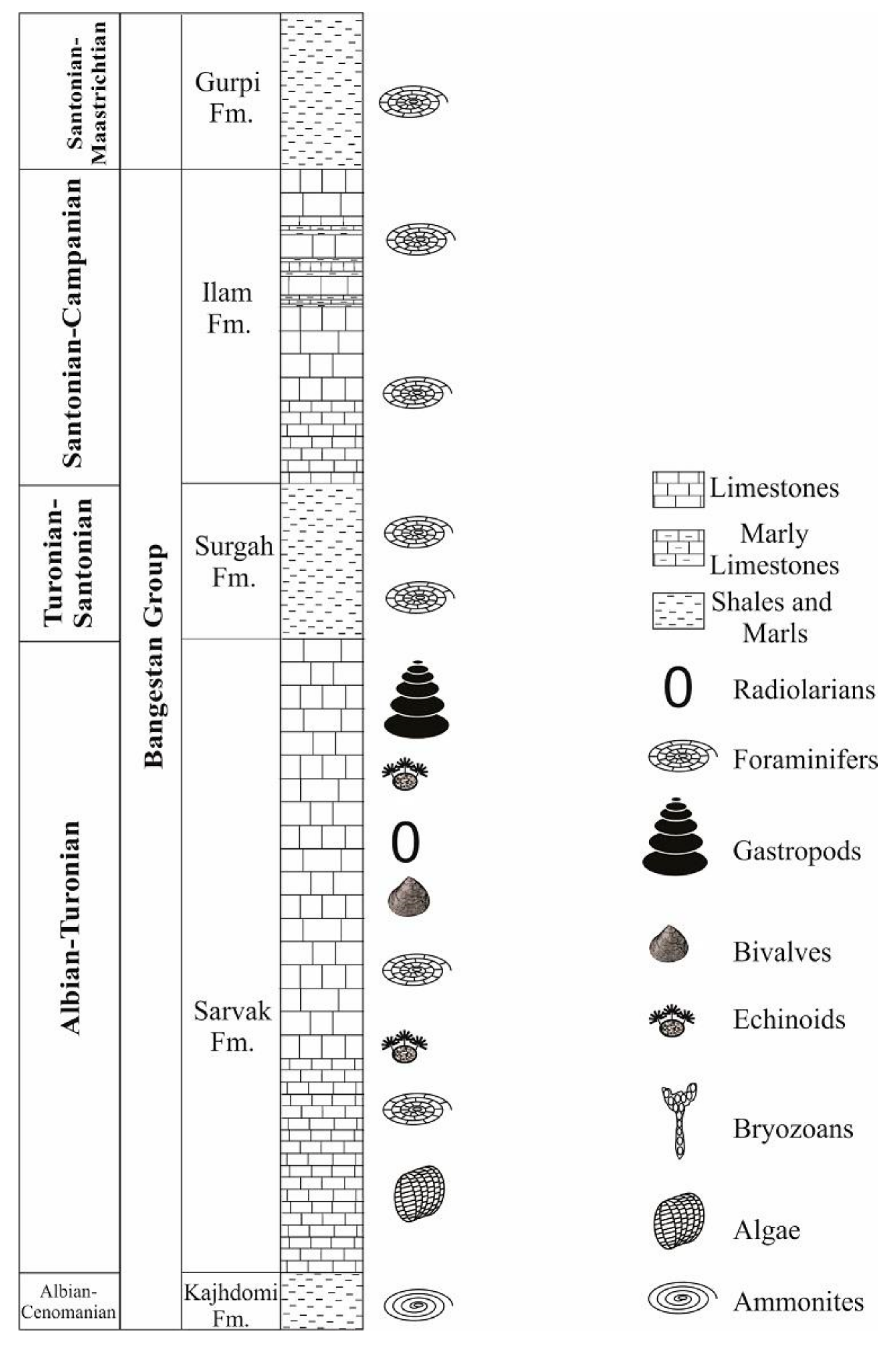
2. Materials and Methods
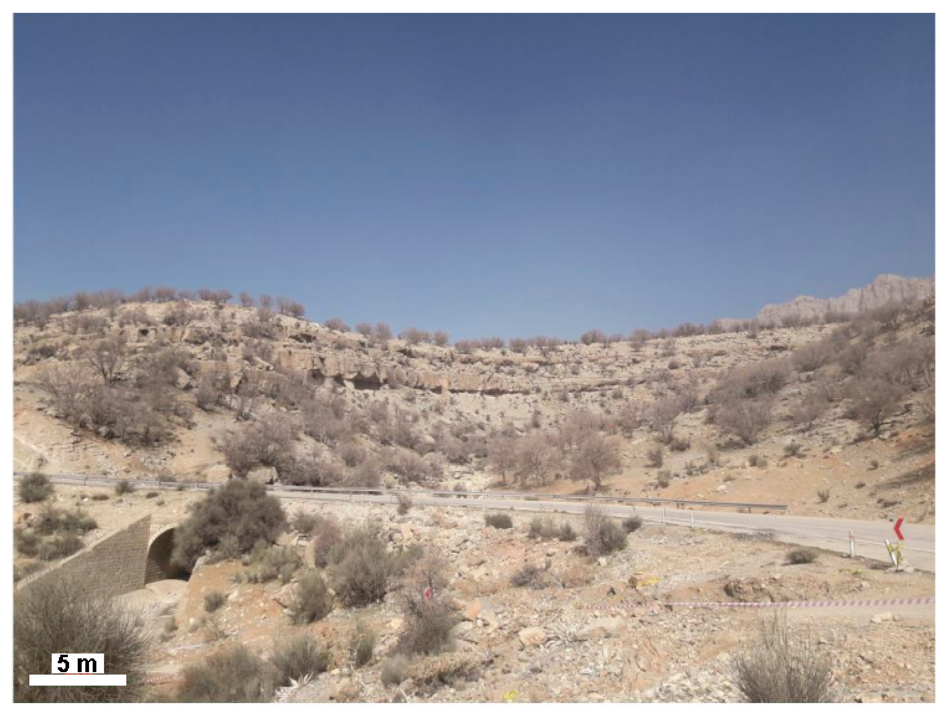
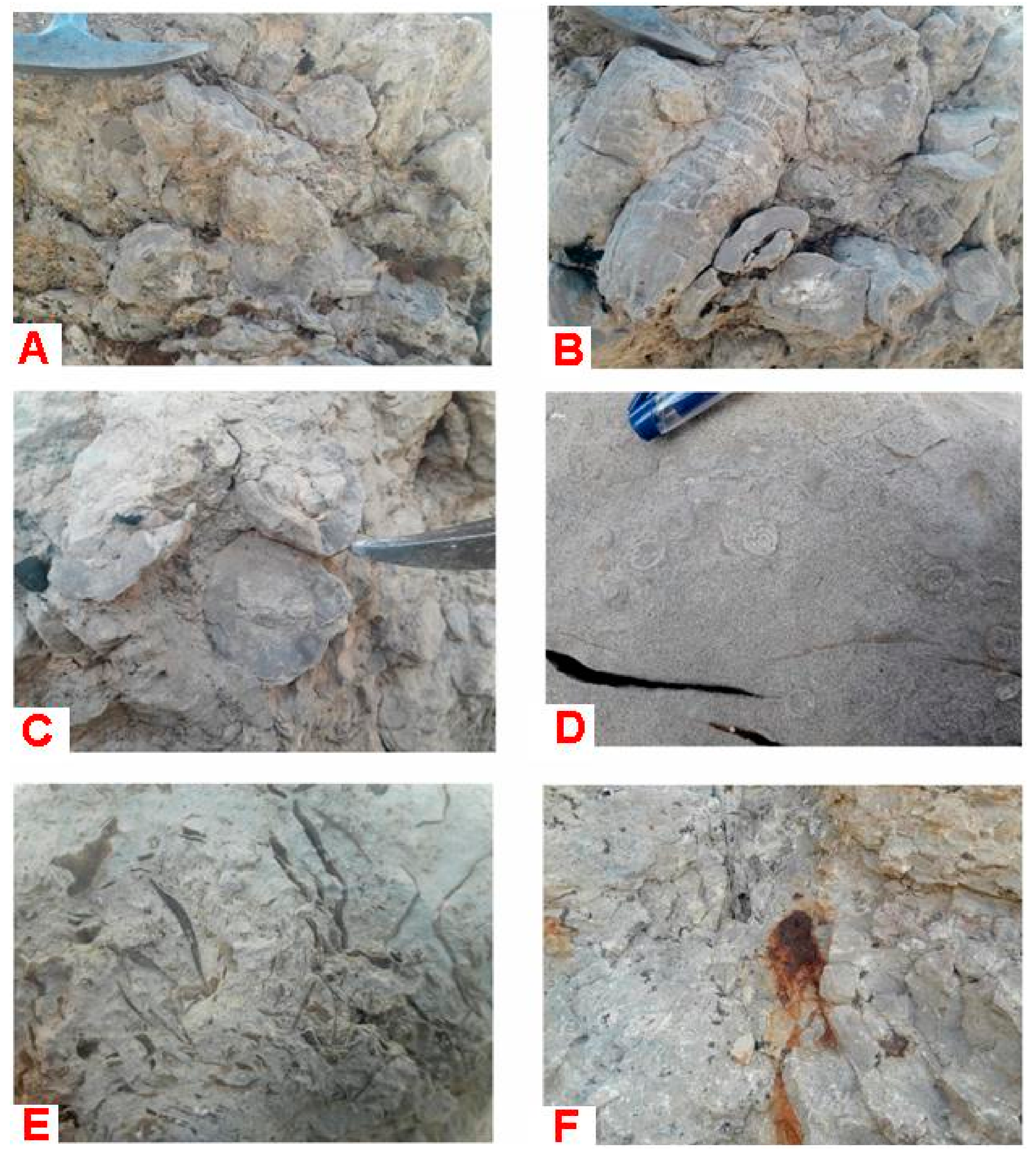
The Middle East boasts outstanding hydrocarbon reserves, a significant part of which is hosted by the Mesozoic carbonate rocks [25,26]. Among the rocks, important reservoirs are carbonate packages of the Bangestan Group in southwest Iran [27]. This geological object is analyzed in the present paper. Geographically, the study area is located in the Zagros Mountains, stretched across the southwestern part of Iran (Figure 1A). It is situated ~70 km to the southwest of Shiraz city and ~20 km to the east of Kazeroon city. The area is crossed by the road making the excellent geological exposures easily accessible.
The geological setting of the study area is characterized by the affinity to the major Cenozoic fold-thrust belt [29,30,31]. The Cretaceous, Paleogene, and Neogene sedimentary rocks are exposed there, and the tectonic contortion resulted in the formation of the northwest–southeast trending Nowdan anticline with older rocks in its core and younger rocks on its flanks (Figure 1B). It is the Bangestan Group that forms the axial part of this anticline. This group is characterized in the works of many specialists, including Ala [32], Asadi Mehmandosti et al. [33], Asghari et al. [34], Bakhtiar et al. [35], Beiranvand et al. [36], Bordenave and Burwood [37], Bordenave and Hegre [38], Farzipour-Saein et al. [39], Hajikazemi et al. [40], Nasseri et al. [41], Senemari et al. [42], Shirazi et al. [43], Taghavi et al. [44], and Telmadarreie et al. [45]. Generally, the Bangestan group is Cretaceous in age, and it includes several formations (Figure 2), from which the Sarvak Formation (mid-Cretaceous) and the Ilam Formation (Late Cretaceous) host especially significant hydrocarbon systems. These two formations are represented by fossiliferous, shallow-water carbonates with the total thickness of up to 1100 m that crop out widely in the study area (Figure 1B). The geological history of the study area reflects the evolution of the entire Zagros orogen [26,27] well. In the Cretaceous, this was a part of the carbonate platform developed on a passive margin of the Arabian Plate, where shallow seawater persisted. In the Cenozoic, this area was involved in a major tectonic re-organization due to plate collision. As a result, the orogen started to grow. Orogenic motions led to the contortion of rocks, and, thus, the Nowdan anticline was formed.
Attention has been paid to all geological features that may be potentially unique in the outcrops of the Bangestan Group (Sarvak and Ilam formations) available in the study area (Figure 1B). Sedimentological and palaeontological features have been investigated in detail because these seem to be the most characteristic peculiarities of the studied rocks. Aesthetical properties have been examined with regard to the common visitors’ perceptions of tourist attractions’ beauty [46]; the specific aesthetic patterns noted by Mikhailenko et al. [47] and Ruban [48] have also been taken into account.
Methodologically, this investigation is based on the general understanding of the geoheritage [22,49,50], its typology [1,22], and some basic approaches for its descriptions [7,49,51]. Characterizing the Bangestan geoheritage resource is possible via seven successive steps. The first step is summarizing the information available from the field (see above) and extracted from the literature (previous descriptions of the Bangestan Group). The second step is the identification of the principal peculiarities of the group, which are later attributed to the geoheritage types distinguished according to Ruban [51] and Habibi et al. [22]. The third step is the establishment of the ranks of each geoheritage type; this is possible via comparison of the features of the Bangestan Group with similar features known in the other areas of Iran and globally. Local rank means spatially restricted uniqueness. Regional rank means province-scale uniqueness. National rank means country-scale uniqueness and global rank means planetary-scale uniqueness [51]. In other words, uniqueness is linked to the rarity of the class of features, to which a given feature belongs. Scientific, educational, and tourism utility of this feature results from natural uniqueness, and only in some cases this pre-existing utility itself may determine the uniqueness. The fourth step is the analysis of the aesthetic properties of the rocks. The presence of the distinctive features known as attracting (geo)tourists [46,47,48] is checked in the studied rock exposures (see also above). The fifth step is the argumentation for the entire geoheritage resource value of the Bangestan Group, i.e., its utility for geoscience research, geoeducation, and geotourism. This analysis requires summarizing the information accumulated at the previous steps, in order to make general judgments. One of the aims is the establishment of the geoheritage rank for the entire Bangestan Group, which is possible via the consideration of the ranks established for the separate features of this geological body. The sixth step is the judgment about the significance of the study area, i.e., the Nowdan anticline as a typical manifestation of the Bangestan geoheritage resource and the possibility of its recognition as a kind of geological heritage site (geosite). The seventh step is the analysis of the state of this geosite in regard to its accessibility, complexity, anthropogenic pressure, and scenic value.

3. Results

Both the field and literature information indicate significant geoheritage potential of the Bangestan Group. The most interesting features of this geological body include carbonate rocks, fossils, stratigraphical markers, facies, folds, and hydrocarbon deposits. Of course, the uniqueness of these features differs significantly. A total of six geoheritage types [22,51] can be distinguished, namely sedimentary, palaeontological, stratigraphical, palaeogeographical, structural, and economic. These are characterized below together with the relevant rank establishment.
The sedimentary type is represented by the carbonate rocks of the Sarvak and Ilam formations, which crop out widely in the study area (Figure 3). These are limestones, which often possess abundant fossil remains (Figure 4A–E). Rudist limestones are especially characteristic (Figure 4A–C). Sometimes, these carbonate rocks demonstrate notable, but obvious lithological peculiarities like iron oxide manifestations in limestones (Figure 4F). A local rank would be assigned to this geoheritage type because comparable rocks appear to be very typical, even for the Fars Province of Iran. However, the Bangestan Group crops out in many parts of the Zagros domain, and rocks of the former are very characteristic to the latter. In such a case, it is sensible to judge the rank of this geoheritage type regional.
The palaeontological type includes numerous fossils that occur in the Sarvak and Ilam formations, namely rudists and other bivalves, bryozoans, algae, echinoids, gastropods, and abundant microfossils (foraminifers, radiolarians, and calcareous nannoplankton). These are reported from almost all levels of the Bangestan Group (Figure 2), and macrofossils are well preserved and often visible in outcrops (Figure 4B,D). Although many areas of Iran and, in particular, the entire Zagros domain, boast rich fossil assemblages of the Cretaceous age, the Bangestan Group is distinguished by the concentration of palaeontological remains. Moreover, it offers a lot of material for specialized studies of rudists. As a result, a regional rank should be assigned to this geoheritage type.
The stratigraphical type has to be recognized because the Bangestan Group provides some very important material for the regional stratigraphical developments. On the one hand, these deposits were used to outline the standard foraminiferal biozonation in the classical works of James and Wynd [52] and Wynd [53], and this biozonation is still in use playing an important role in hydrocarbon exploration. On the other hand, the Upper Cretaceous biostratigraphical framework has recently been improved by Senemari et al. [42] with the data on calcareous nannofossils from the Ilam Formation. In regard to the regional focus of the above mentioned stratigraphical developments, the rank of this geoheritage type should be classified as regional.
The palaeogeographical type is identified because of facies, palaeoecological, and taphonomic peculiarities of the Bangestan Group. The carbonates of the Sarvak and Ilam formations accumulated in the shallow, marine environments of ramp-like platforms. These limestones represent a spectrum of facies, including tidal flat, lagoonal, shoal, and open marine facies belts [33] of a warm, low-latitude palaeoenvironment [42]. Bioherms are interesting from the palaeoecological point of view, and fossil-rich layers (Figure 4A–E) provide interesting evidence of taphonomic patterns. However, all these palaeogeographical features are very common in the Zagros domain of Iran, even on the scale of the Fars Province. Therefore, a local rank should be assigned to this geoheritage type.
The structural type is related to the contorted layers of the Bangestan Group. On the one hand, tectonic deformation resulted in the development of large-scale folds, a typical example of which is the entire Nowdan anticline (Figure 1B). On the other hand, some gentle folding is visible in single outcrops (Figure 3). Although folds are very typical for the fold-thrust belt of the Zagros Mountains [27,29,30,31], their exceptional (almost “textbook-like”) appearance in the case of the Bangestan Group, allows identification of this geoheritage type. However, its rank is not more than local because similar objects of the other age can be found in many other locations of the Fars Province, i.e., the rarity is lower than regional.
Finally, the economic type is linked to the outstanding hydrocarbon potential of the Bangestan Group [27,32,41]. The carbonate reservoirs of the latter are among the most important in Iran and the entire Middle East. Particularly, the Ilam Formation, which is divided into several oil reservoir units [41]. The Dezful embayment is among the main areas for oil production in Iran, and the noted reservoirs determine its importance. In regard to the significance of the oil industry for the Iranian economy and the world positioning of this industry [1], it becomes evident that the uniqueness of the hydrocarbon-related features is really significant, and it is national. The same rank should be assigned to this geoheritage type.
The documented aesthetic properties are linked to the layering of the carbonate rocks and panoramic views of the local geological landscape. Mikhailenko et al. [47] recognized striped and lined patterns and contorted patterns of geological structures in outcrops as aesthetically attractive. In the case of the Bangestan Group, both types of patterns exist (Figure 3) and result from the successive deposition of carbonates and later tectonic deformations. Ruban [48] introduced the idea of geological heritage landscapes, i.e., natural landscapes dominated by unique geological features. Multiple exposures of the Bangestan rocks are not masked by vegetation or debris form such a landscape in the study area (Figure 3). However, many aesthetic properties important to visitors [46] are not established locally.
The geoheritage resource value of the Bangestan Group is linked to its importance to different types of human activity and brings a number of socio-economic benefits. First, the Bangestan Group offers a lot of possibilities for high-class geoscience research. Particularly, this can be linked to detailed investigations of the fossil assemblages (with emphasis on rudists, echinoids, and microfossils), improvement of the regional stratigraphical framework according to the modern developments of the International Commission on Stratigraphy, and the recognition of global Cretaceous events (first of all, oceanic anoxic events) in the regional sedimentary successions. When the information for the present paper was collected, it had been realized that the available descriptions of the Bangestan Group were either too scarce or too general. Indeed, the characteristics of this interesting geological body should be detailed. Second, the Bangestan Group is very interesting to geoeducation, especially to students in geosciences and petroleum engineering from Iranian universities. This geological object provides an explanation of the reservoir rock properties, demonstration of some specific fossils, and training geological mapping skills in folded domains. Third, geotourism potential of the Bangestan Group is determined by two facts, namely the rise of interest to geotourism in Iran [54] and possibilities for geotourism coupling with the other types of heritage-based tourism in the Fars Province [22]. The above-mentioned uniqueness of the group (especially, the high rank of the economic geoheritage type) makes the latter attractive to various sorts of visitors, including academic and other dedicated geotourists. The natural exposures of the Bangestan Group represent the typical geological landscapes of the Zagros domain and stress the links between these landscapes and the oil production as the nationally leading industry.
In general, the Bangestan geoheritage resource should be valued nationally. The geological features of this group deserve conservation because of their uniqueness. At least, these should be promoted as a kind of heritage to increase the awareness of the potentially interested stakeholders (e.g., geoconservation activists). As one type is of national rank (see above), the premise for serious consideration of this geoheritage is strong.
The Bangestan Group crops out on a vast territory, but the study area, i.e. the Nowdan anticline, exhibits all its characteristic features. Visitors can observe carbonate rocks, the lithological peculiarities of which permit easy judgments of reservoir properties, as well as abundant fossils, folds, etc. This area is proposed to be recognized as a single geosite. In fact, it possesses several representative outcrops (Figure 1B), but these are quite similar, spatially connected, and their identification as separate geosites is not necessary. Moreover, the moderate size of the study area does not prohibit its entire designation as a geosite. The rank of this geosite is definitely national because this geosite represents the Bangestan geoheritage resource that is also valued nationally. However, the Nowdan anticline also provides information about some of the other geological formations (Figure 1B), and, thus, the higher rank is not excluded (these issues are highly-complex and not linked to the Bangestan Group, and, thus, their discussion is beyond the scope of the present paper). The proposed geosite is easily accessible because of the road crossing it (Figure 1B). It demonstrates certain geodiversity because of the coincidence of six geoheritage types, but this complexity is not too high to make the understanding of the local geological landscape difficult. The present anthropogenic pressure on the area is minimal, and it is only linked to the road maintenance. The scenic value is moderate because of the restricted aesthetic properties of the Bangestan Group (see above) balanced with a high, almost panoramic visibility of the entire geological heritage landscape that is typical to the Zagros Mountains.

4. Discussion

Although geoheritage resources can be exploited in different ways, the most evident and economically profitable approach is their use for tourism development [20]. Geotourism can bring serious socio-economic benefits [3,21,55,56,57], but it also helps to diversify the existing tourism practices and economic activity in general. These are important mechanisms of the local sustainable development; providing new jobs, increasing cultural exchange, and promoting the local (as well as regional and national) image and brands. Undoubtedly, geotourism may significantly affect the local geoconservation initiatives by uncontrolled crowds of visitors damaging geosites, changing their natural morphology, and making the scenery less authentic because of infrastructure development.
In the case of the hydrocarbon-related geoheritage, geotourism can play an even more complex role. Typical tourist activities linked to oil production include visits to open or already closed infrastructural sites or the creation of special museums feeding with some historical information, displaying technical advances, and offering interactive exhibits. However, such tourist attractions can be significantly developed if connected with nature-based geosites. This solution permits visitors to better comprehend the idea of hydrocarbons (not only their production, but also origin and broad natural context) and to diversify the experience; both should increase visitors’ satisfaction. To oil companies, the development of industrial tourism and its merging with geotourism is important for image improvement and brand promotion.
Geotourism itself can benefit from such a complex exploitation of the hydrocarbon-related geoheritage resource. Recently, when geotourism activities have started to rise globally [4,54], industrial tourism has proved a well-established direction of tourism, and its attractions are really popular [58,59,60,61,62,63,64]. As a result, it is industrial heritage that can attract visitors and facilitate their involvement in geotourism activities. In hydrocarbon-exporting countries, the outstanding importance of the national oil industry determines the heritage value of the relevant industrial objects, making them interesting to numerous visitors. The history of oil production in this country and the relevant heritage, including abandoned infrastructure objects are also attractive [5]. Hydrocarbon-related industrial tourism may include visits to oil-mining enterprises with the demonstration of drilling equipment. If production and safety issues allow, visitors can even participate in the process of oil production, enabling some equipment or, at least, to purchase some thematic souvenirs like a bottle with natural oil. When such activities bring benefits, it contributes (even if in small amount) to less dependence on national economies of the hydrocarbon export. The relevant ideas are conceptualized on Figure 5.
The exploitation of the Bangestan geoheritage resource for the purposes of tourism requires the choice of a proper strategy for the Nowdan anticline. The latter can be declared officially as a geosite of national rank. Any nature protection status is not necessary due to the absence of strong anthropogenic pressure. On the one hand, the naturally exposed rocks of the Bangestan Group are hard to the occasional mechanical influence, and the slopes seem to be stable (Figure 3). On the other hand, crowds of visitors are not expected, and the required infrastructure development is minimal (see below). The only possible tourist activity that needs regulation is fossil collecting. Although fossils are abundant, these may be over-sampled, and, consequently, the palaeontological value will be lost. However, the risk for such a loss is low because over-sampling is only possible if there are a high number of visitors. The Nowdan anticline geosite needs infrastructure to be built, including signs that indicate the routes to the main features (the area is not so small in size), explanatory panels (particularly, fossils, facies, and hydrocarbon reserves need proper explanation to unprepared visitors), and well-designed trails (visiting the main features require hiking). The creation of a geopark is not sensible because of the geosite homogeneity. However, in the case of a possibly bigger geopark, embracing various geoheritage features of the Fars Province [7], the Nowdan anticline geosite can become its significant constituent.
More important is the joint development of the regional industrial tourism and geotourism programs in the vicinities of Shiraz. Earlier propositions of such a project for the other province of Iran [5] may be useful for the solution of this task. For instance, it is possible to create an oil museum or special visitor centre that provides excursions to some oil industry objects and the discussed geosite. The museum/visitor centre can be located in Shiraz, which is a world-class tourist destination. Excursions to the closely located Nowdan anticline and the Sarvestan and Saadatabad oil fields can be organized in Figure 6. As these objects are located along the routes of other cultural tourist attractions, geotourism and industrial tourism can flourish via the facilitation of the entire local tourism industry.

5. Conclusions

The present study allows three general conclusions. First, the Bangestan Group should be considered not only as a hydrocarbon reservoir, but also as a geoheritage object comprising of six geoheritage types. Second, the Bangestan geoheritage is a resource needing geoconservation and is valuable for geoscientific research, geoeducation, and geotourism. Third, the Bangestan geoheritage resource is best represented in the Nowdan anticline, which has to be recognized as a large geosite that needs joint involvement in industrial tourism and geotourism programs. Further investigations should be aimed at finding other geoheritage objects in the Fars Province of Iran for the development of the regional strategy of geoconservation and geotourism.

Author Contributions

conceptualization, T.K.M. and D.A.R.; interpretation, T.K.M. and D.A.R.; writing, D.A.R.

Funding

This research received no external funding.

Acknowledgments

The journal editors and the reviewers are thanked for their support and suggestions. Tahereh Habibi (Iran) is thanked deeply for providing the material of field investigations, various discussions, and assistance with figure preparation.

Conflicts of Interest

The authors declare no conflict of interest. Tahereh Habibi (Iran) provided the permission for publication of her material.

References

  1. OPEC Monthly Oil Market Report, 13 November 2018; OPEC: Vienna, Austria, 2018; pp. 1–93. Available online: https://www.opec.org/opec_web/static_files_project/media/downloads/publications/MOMR%20November%202018.pdf (accessed on 25 December 2018).
  2. Henriques, M.H.; Pena dos Reis, R.; Brilha, J.; Mota, T. Geoconservation as an Emerging Geoscience. Geoheritage 2011, 3, 117–128. [Google Scholar] [CrossRef]
  3. Gordon, J.E. Geoheritage, geotourism and the cultural landscape: Enhancing the visitor experience and promoting geoconservation. Geosciences 2018, 8, 136. [Google Scholar] [CrossRef]
  4. Ruban, D.A. Geotourism—A geographical review of the literature. Tour. Manag. Perspect. 2015, 15, 1–15. [Google Scholar] [CrossRef]
  5. Bahrainy, H.; Jahani Moghadam, H.R. Utilizing local potentials for tourism promotion—“Case study: Oil park-museum in Masjed-i-Soleiman”. J. Environ. Stud. 2004, 30, 33–50. [Google Scholar]
  6. dos Reis, R.P.; Henriques, M.H. Geoheritage and advanced training for the oil industry: The Lusitanian Basin case study (Portugal). Am. Assoc. Pet. Geol. Bull. 2018, 102, 1413–1428. [Google Scholar] [CrossRef]
  7. Habibi, T.; Ruban, D.A. The Oligocene carbonate platform of the Zagros Basin, SW Iran: An assessment of highly-complex geological heritage. J. Afr. Earth Sci. 2017, 129, 675–682. [Google Scholar] [CrossRef]
  8. Klamar, R.; Matlovic, R.; Mitura, T.; Buczek-Kowalik, M.; Kopor, I. Development of geoturism and mining heritage on the examples of Slovak opal mines and oil mine Bóbrka. Int. Multidiscip. Sci. Geoconf. Surv. Geol. Min. Ecol. Manag. SGEM 2017, 17, 241–248. [Google Scholar]
  9. Kruczek, M.; Kruczek, Z. Post-industrial tourism as a means to revitalize the environment of the former oil basin in the Polish Carpathian Mountains. Pol. J. Environ. Stud. 2016, 25, 895–902. [Google Scholar] [CrossRef]
  10. Luud, A.; Liblik, V.; Sepp, M. Landscape evaluation in industrial areas. Oil Shale 2003, 20, 25–32. [Google Scholar]
  11. Metsaots, K.; Sepp, K.; Roose, K.A. Evaluation of oil shale mining heritage in Estonia. Wit Trans. Ecol. Environ. 2011, 150, 453–467. [Google Scholar]
  12. Metsaots, K.; Printsmann, A.; Sepp, K. Public Opinions on Oil Shale Mining Heritage and its Tourism Potential. Scand. J. Hosp. Tour. 2015, 15, 380–399. [Google Scholar] [CrossRef]
  13. Price, W.R.; Ronck, C.L. Gushing about black gold: Oil and natural gas tourism in Texas. J. Herit. Tour. 2018, 13, 440–454. [Google Scholar] [CrossRef]
  14. Raukas, A.; Tavast, E. Sustainable management of mineral resources, soil cover and geosites in Estonia. Pol. Geol. Inst. Spec. Pap. 2004, 13, 191–197. [Google Scholar]
  15. Searle, M. Preserving Oman’s geological heritage: Proposal for establishment of world heritage sites, national geoparks and sites of special scientific interest (SSSI). Geol. Soc. Spec. Publ. 2014, 392, 9–44. [Google Scholar] [CrossRef]
  16. Sepp, K.; Roose, A. Towards multifunctionality of mining landscapes in the Estonian oil shale basin: Typologies, assessment and planning. Oil Shale 2009, 26, 432–441. [Google Scholar] [CrossRef]
  17. Brilha, J.; Gray, M.; Pereira, D.I.; Pereira, P. Geodiversity: An integrative review as a contribution to the sustainable development of the whole of nature. Environ. Sci. Policy 2018, 86, 19–28. [Google Scholar] [CrossRef]
  18. Gray, M. Geodiversity. Valuing and Conserving Abiotic Nature; Wiley-Blackwell: Chichester, UK, 2013; pp. 1–495. [Google Scholar]
  19. Prosser, C.D. Our rich and varied geoconservation portfolio: The foundation for the future. Proc. Geol. Assoc. 2013, 124, 568–580. [Google Scholar] [CrossRef]
  20. Ruban, D.A. Geodiversity as a precious national resource: A note on the role of geoparks. Resour. Policy 2017, 53, 103–108. [Google Scholar] [CrossRef]
  21. Ruban, D.A.; Tiess, G.; Sallam, E.S.; Ponedelnik, A.A.; Yashalova, N.N. Combined mineral and geoheritage resources related to kaolin, phosphate, and cement production in Egypt: Conceptualization, assessment, and policy implications. Sustain. Environ. Res. 2018, 28, 454–461. [Google Scholar] [CrossRef]
  22. Habibi, T.; Ponedelnik, A.A.; Yashalova, N.N.; Ruban, D.A. Urban geoheritage complexity: Evidence of a unique natural resource from Shiraz city in Iran. Resour. Policy 2018, 59, 85–94. [Google Scholar] [CrossRef]
  23. Maghsoudi, M.; Rahmati, M. Geomorphosites assessment of Lorestan Province in Iran by comparing of Zouros and Comanescus’s methods (case study: Poldokhtar area, Iran). Geo J. Tour. Geosites 2018, 21, 226–238. [Google Scholar]
  24. Pourahmad, A.; Hosseini, A.; Pourahmad, A.; Zoghi, M.; Sadat, M. Tourist Value Assessment of Geotourism and Environmental Capabilities in Queshm Island, Iran. Geoheritage 2018, 10, 687–706. [Google Scholar] [CrossRef]
  25. Murris, R.J. Middle East: Stratigraphic evolution and oil habitat. Am. Assoc. Pet. Geol. 1980, 64, 597–618. [Google Scholar]
  26. Setudehnia, A. The Mesozoic sequence in southwest Iran and adjacent areas. J. Pet. Geol. 1978, 1, 3–42. [Google Scholar] [CrossRef]
  27. Motiei, H. Geology of Iran. The Stratigraphy of Zagros; Geological Survey of Iran: Tehran, Iran, 1993; pp. 1–536. (In Farsi) [Google Scholar]
  28. MacLeod, J.H.; Majedi, M. Geological Map of Kazeroun, 1:100000 Scale; Iranian Oil Operating Companies: Tehran, Iran, 1972. [Google Scholar]
  29. Aldega, C.; Bigi, S.; Carminat, E.; Trippetta, F.; Corrado, S.; Kavoosi, M.A. The Zagros fold-and-thrust belt in the Fars province (Iran): II. Thermal evolution. Mar. Pet. Geol. 2018, 93, 376–390. [Google Scholar] [CrossRef]
  30. Alavi, M. Structures of the Zagros fold-thrust belt in Iran. Am. J. Sci. 2007, 307, 1064–1095. [Google Scholar] [CrossRef]
  31. Bigi, S.; Carminati, E.; Aldega, L.; Trippetta, F.; Kavoosi, M.A. Zagros fold and thrust belt in the Fars province (Iran) I: Control of thickness/rheology of sediments and pre-thrusting tectonics on structural style and shortening. Mar. Pet. Geol. 2018, 91, 211–224. [Google Scholar] [CrossRef]
  32. Ala, M.A. Chronology of trap formation and migration of hydrocarbons in Zagros sector of southwest Iran. Am. Assoc. Pet. Geol. Bull. 1982, 66, 1535–1541. [Google Scholar]
  33. Asadi Mehmandosti, E.; Adabi, M.H.; Woods, A.D. Microfacies and geochemistry of the Middle Cretaceous Sarvak Formation in Zagros Basin, Izeh Zone, SW Iran. Sediment. Geol. 2013, 293, 9–20. [Google Scholar] [CrossRef]
  34. Asghari, M.; Tahmasebi Poor, A.; Barari, A. Original mineralogy and recognition of upper boundary of the Sarvak formation based on geochemistry and isotope studies. Pet. Sci. Technol. 2014, 32, 1265–1273. [Google Scholar] [CrossRef]
  35. Bakhtiar, H.A.; Telmadarreie, A.; Ashkan, S.M.A.; Amani, S. Correlation of source rocks and crude oils in Kupal and its near oil fields, SW of Iran. Energy Sources Part A Recovery Util. Environ. Eff. 2016, 38, 1553–1561. [Google Scholar] [CrossRef]
  36. Beiranvand, B.; Ahmadi, A.; Sharafodin, M. Mapping and classifying flow units in the upper part of the Middle Cretaceous Sarvak Formation (western Dezful Embayment, SW Iran) based on a determination of the reservoir types. J. Pet. Geol. 2007, 30, 357–373. [Google Scholar] [CrossRef]
  37. Bordenave, M.L.; Burwood, R. Source rock distribution and maturation in the Zagros Orogenic Belt: Provenance of the Asmari and Bangestan Reservoir oil accumulations. Org. Geochem. 1990, 16, 369–387. [Google Scholar] [CrossRef]
  38. Bordenave, M.L.; Hegre, J.A. Current distribution of oil and gas fields in the Zagros fold belt of Iran and contiguous offshore as the result of the petroleum systems. Geol. Soc. Lond. Spec. Publ. 2010, 330, 291–353. [Google Scholar] [CrossRef]
  39. Farzipour-Saein, A.; Yassaghi, A.; Sherkati, S.; Koyi, H. Basin evolution of the Lurestan region in the Zagros fold-and-thrust belt, Iran. J. Pet. Geol. 2009, 32, 5–19. [Google Scholar] [CrossRef]
  40. Hajikazemi, E.; Al-Aasm, I.S.; Coniglio, M. Subaerial exposure and meteoric diagenesis of the Cenomanian-Turonian Upper Sarvak Formation, southwestern Iran. Geol. Soc. Lond. Spec. Publ. 2010, 330, 253–272. [Google Scholar] [CrossRef]
  41. Nasseri, A.; Mohammadzadeh, M.J.; Hashemtabatabaee, S. Evaluating Bangestan reservoirs and targeting productive zones in Dezful embayment of Iran. J. Geophys. Eng. 2016, 13, 994–1001. [Google Scholar] [CrossRef]
  42. Senemari, S.; Tehrani, M.B.; Mohammadi, F. Nannofossil events and stratigraphy of the Ilam formation in Zagros (SW Iran). Rivista Italiana di Paleontologia e Stratigrafia 2014, 120, 103–108. [Google Scholar]
  43. Shirazi, M.P.-N.; Bahrami, M.; Rezaee, B.; Gharamani, S. Microbiostratigraphy of Kazhdumi formation in the Northwestern Shiraz (Southwest Iran) on the basis of foraminifera and calcareous algae. Acta Geol. Sin. 2011, 85, 777–783. [Google Scholar] [CrossRef]
  44. Taghavi, A.A.; Mork, A.; Emadi, M.A. Sequence stratigraphically controlled diagenesis governs reservoir quality in the Dehluran field, SW Iran. Pet. Geosci. 2006, 12, 115–126. [Google Scholar] [CrossRef]
  45. Telmadarreie, A.; Shadizadeh, S.R.; Alizadeh, B. Correlation of oils and source rocks in Marun oil field in the South West of Iran: Using biomarkers. Energy Sources Part A Recovery Util. Environ. Eff. 2015, 37, 200–208. [Google Scholar] [CrossRef]
  46. Kirillova, K.; Fu, X.; Lehto, X.; Cai, L. What makes a destination beautiful? Dimensions of tourist aesthetic judgment. Tour. Manag. 2014, 42, 282–293. [Google Scholar] [CrossRef]
  47. Mikhailenko, A.V.; Nazarenko, O.V.; Ruban, D.A.; Zayats, P.P. Aesthetics-based classification of geological structures in outcrops for geotourism purposes: A tentative proposal. Geologos 2017, 23, 45–52. [Google Scholar] [CrossRef]
  48. Ruban, D.A. Aesthetic properties of geological heritage landscapes: Evidence from the Lagonaki Highland (Western Caucasus, Russia). J. Geogr. Inst. 2018, 68, 289–296. [Google Scholar] [CrossRef]
  49. Brilha, J. Inventory and quantitative assessment of geosites and geodiversity sites: A review. Geoheritage 2016, 8, 119–134. [Google Scholar] [CrossRef]
  50. Reynard, E.; Brilha, J. (Eds.) Geoheritage: Assessment, Protection, and Management; Elsevier: Amsterdam, The Netherlands, 2018; pp. 1–482. [Google Scholar]
  51. Ruban, D.A. Quantification of geodiversity and its loss. Proc. Geol. Assoc. 2010, 121, 326–333. [Google Scholar] [CrossRef]
  52. James, G.A.; Wynd, J.G. Stratigraphic Nomenclature of Iranian Oil Consortium Agreement Area. Am. Assoc. Pet. Geol. Bull. 1965, 49, 2182–2245. [Google Scholar]
  53. Wynd, A.G. Biofacies of the Iranian Oil Consortium Agreement Area; Iranian Offshore Oil Company Report; Iranian Offshore Oil Company: Tehran, Iran, 1965; p. 1082. [Google Scholar]
  54. Ólafsdóttir, R.; Tverijonaite, E. Geotourism: A systematic literature review. Geosciences 2018, 8, 234. [Google Scholar] [CrossRef]
  55. Ehsan, S.; Shafeealeman, M.; Arabegum, R. Geotourism: A tool for sustainable development of geoheritage resources. Adv. Mater. Res. 2013, 622, 1711–1715. [Google Scholar] [CrossRef]
  56. Ernawati, N.M.; Sitawati, A.A.R.; Muliati, N.K. Batur toward sustainable tourism development—A community-based geotourism case from Bali in Indonesia. J. Environ. Manag. Tour. 2018, 9, 291–297. [Google Scholar] [CrossRef]
  57. Eshraghi, M.; Ahmad, H.; Toriman, M.E. Contribution of geomorphological assessment for sustainable geotourism: A case of Iran’s Desert. Adv. Environ. Biol. 2012, 6, 1188–1195. [Google Scholar]
  58. Andrade, M.; Caamaño-Franco, I. Theoretical and methodological model for the study of social perception of the impact of industrial tourism on local development. Soc. Sci. 2018, 7, 217. [Google Scholar] [CrossRef]
  59. Bujok, P.; Klempa, M.; Jelínek, J.; Porzer, M.; Rodríguez Gonzalez, M.A.G. Industrial tourism in the context of the industrial heritage. Geo J. Tour. Geosites 2015, 15, 81–92. [Google Scholar]
  60. Laloyaux, S. Which industrial tourism in tourcoing? (Area of Lille). Int. J. Sustain. Dev. Plan. 2016, 11, 436–446. [Google Scholar] [CrossRef]
  61. Lee, C.-F. An investigation of factors determining industrial tourism attractiveness. Tour. Hosp. Res. 2016, 16, 184–197. [Google Scholar] [CrossRef]
  62. Otgaar, A. Towards a common agenda for the development of industrial tourism. Tour. Manag. Perspect. 2012, 4, 86–91. [Google Scholar] [CrossRef]
  63. Perfetto, M.C.; Presenza, A. Conceptualising industrial heritage tourism management. Int. J. Tour. Policy 2017, 7, 110–128. [Google Scholar] [CrossRef]
  64. Wu, T.; Wall, G.; Yu, W. Creative Turns in the Use of Industrial Resources for Heritage Tourism in Taiwan. J. China Tour. Res. 2016, 12, 414–433. [Google Scholar] [CrossRef]
Figure 1. Location of the Bangestan geoheritage resource: (A)—geographical location, (B)—geological setting; red asterisks mark outcrops; geological map is modified from [28]; (B)—drawing of T. Habibi (published with permission).
Resources 08 00035 g001
Figure 2. Composite stratigraphic section and distribution of the characteristic fossils of the Bangestan Group; drawing of T. Habibi (published with permission).
Resources 08 00035 g002
Figure 3. Different views of the outcrops of the Bangestan Group at the Nowdan anticline; photo provided by T. Habibi (published with permission).
Resources 08 00035 g003
Figure 4. Some palaeontological and sedimentological features of the Bangestan rocks from the Nowdan anticline: (AC) Hippurites-bearing limestone, (D) echinoderm-bearing limestone, (E) bivalve-bearing limestone, (F) limestone with iron oxide; these features indicate the dominant lithology of the group, as well as reflect the richness of biota in the ancient sea and the mode of its preservation in rocks; photos provided by T. Habibi (published with permission).
Resources 08 00035 g004
Figure 5. Benefits from hydrocarbon-based industrial tourism coupled with geotourism; the authors’ drawing.
Resources 08 00035 g005
Figure 6. Schematic representation of the geological and industrial excursion possibilities in the Fars Province; the authors’ drawing.
Resources 08 00035 g006

