
Groundwater Quantity and Quality Issues in a Water-Rich Region: Examples from Wisconsin, USA


Abstract
:
1. Introduction


| Water Use | Percentage of Total |
|---|---|
| Agricultural Irrigation | 40% |
| Municipal Public Water | 37% |
| Industrial | 5% |
| Aquaculture | 3% |
| Cranberry Production | 4% |
| All other uses | 11% |
2. Geologic Setting
2.1. Precambrian Geology
2.2. Paleozoic History
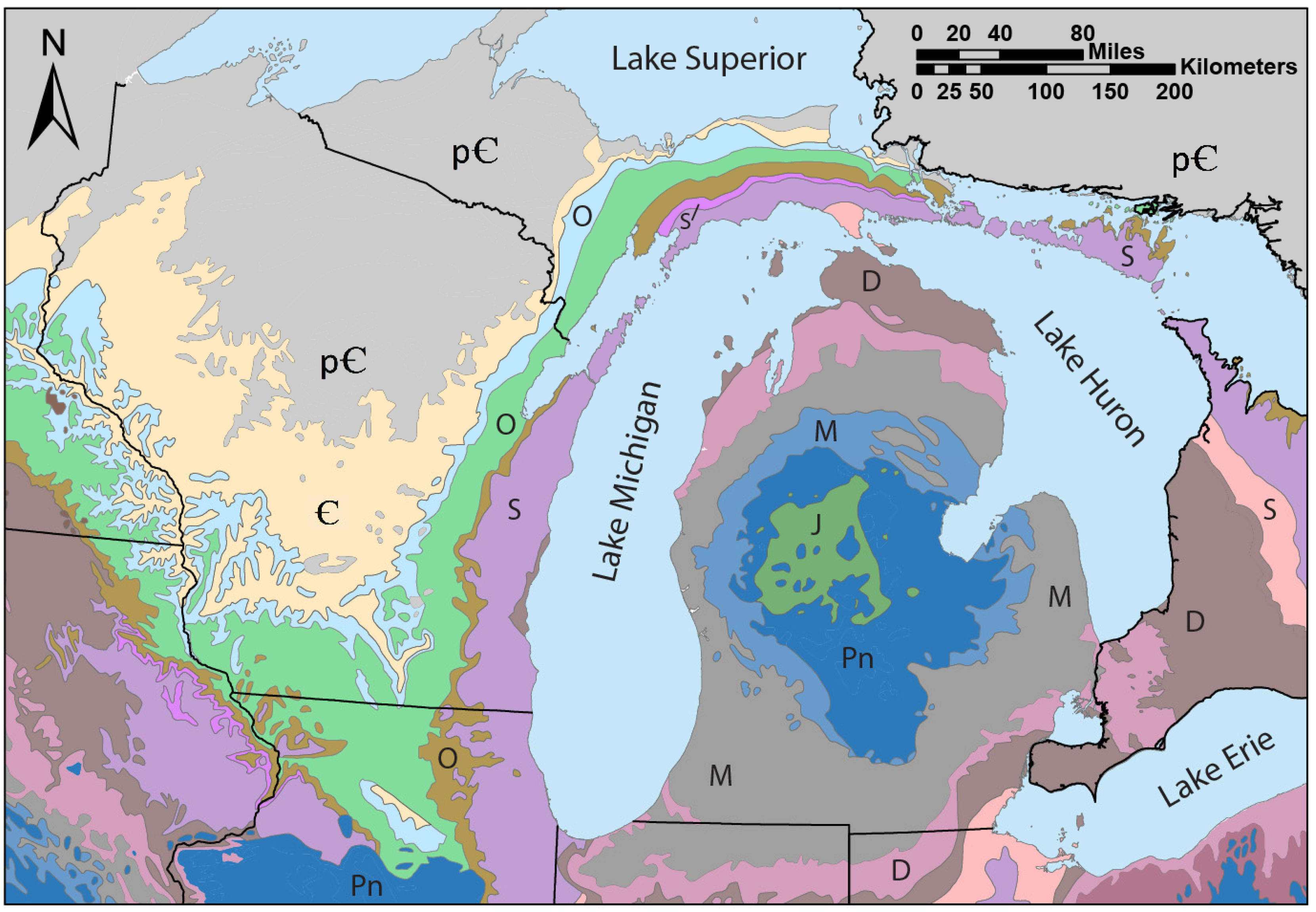
2.3. Quaternary History
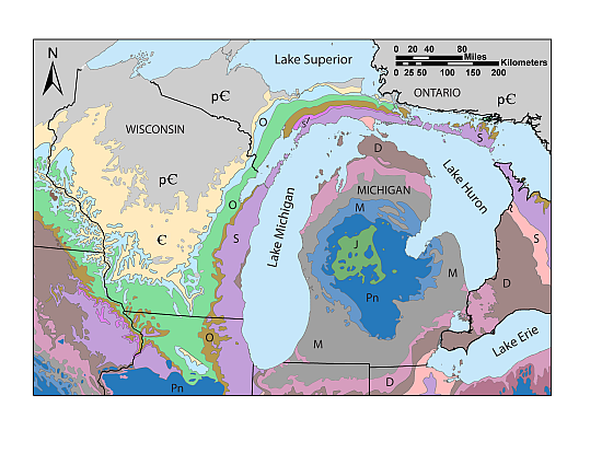
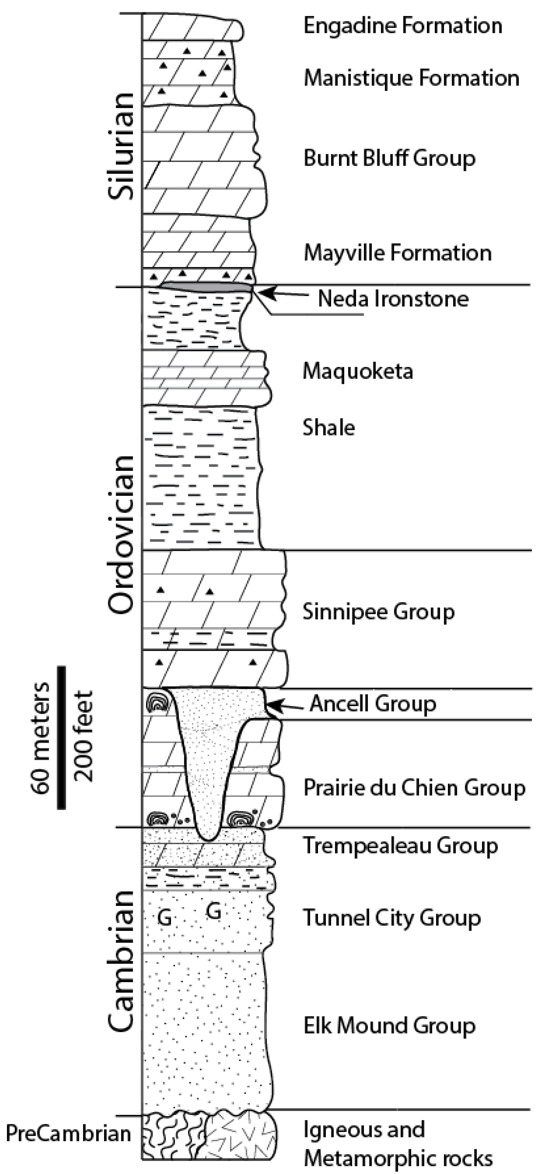
2.4. Hydrostratigraphy
| Geologic Age | Geologic Unit (Thickness, Meters) | Lithology | Hydrostratigraphic Unit | |
|---|---|---|---|---|
| Cenozoic | Quaternary (Pleistocene) | Unconsolidated deposits (0–60 meters) Locally >150 m | Lacustrine silt and clay, glacial till, fluvial sand and gravel, and other deposits. | Local unconfined aquifer (sand and gravel) or regional confining unit (lacustrine clays and tills). |
| Paleozoic | Devonian | Black shale locally over limestone and dolostone. | Upper Aquifer; only present in southeastern Wisconsin along Lake Michigan Shoreline. | |
| Silurian | Undifferentiated (0–240 m) | Dolostone; fractured and karsted in many locations. | Upper Aquifer; Karsted in many locations of northeastern Wisconsin. | |
| Ordovician | Maquoketa Formation (0–150 meters) | Shale, dolomitic shale, and dolomite. | Confining Units; Sinnipee Group Carbonates are locally used as aquifers for domestic use. | |
| Sinnipee Group (120 meters) | Dolostone with some shale. Limestone in portions of southwestern Wisconsin. | |||
| Ancell Group (0–90 meters) | Silty sandstone, fine- to medium-grained sandstone, sandy shale. | Confined Deep Aquifer. | ||
| Prairie du Chien Group (0–60 meters) | Dolostone with varying amounts of oolitic chert and minor interbedded sandstone. | Generally an aquitard relative to the adjacent sandstones in eastern Wisconsin; effective aquifer in western Wisconsin. | ||
| Cambrian | Trempealeau Group (0–15 m) | Fine- to medium-grained sandstone with some silty glauconitic dolomite. | Confined Deep Aquifer. | |
| Tunnel City Group (30–46 m) | Fine- to medium-grained sandstone, silty sandstone to sandy dolomite. Abundant glauconite commonly observed. | |||
| Elk Mound Group (75–90 m) | Very-fine to coarse-grained sandstone. | |||
| Precambrian | Precambrian | Undifferentiated | Crystalline rock, predominantly red granite, contains igneous and metamorphic rock. Limited sedimentary rocks (sandstones, dolostones). | Yields little to no water in many cases. Local aquifers, especially in Midcontinent Rift System rocks of northwestern Wisconsin. |
3. Groundwater Quantity Concerns
3.1. Overview
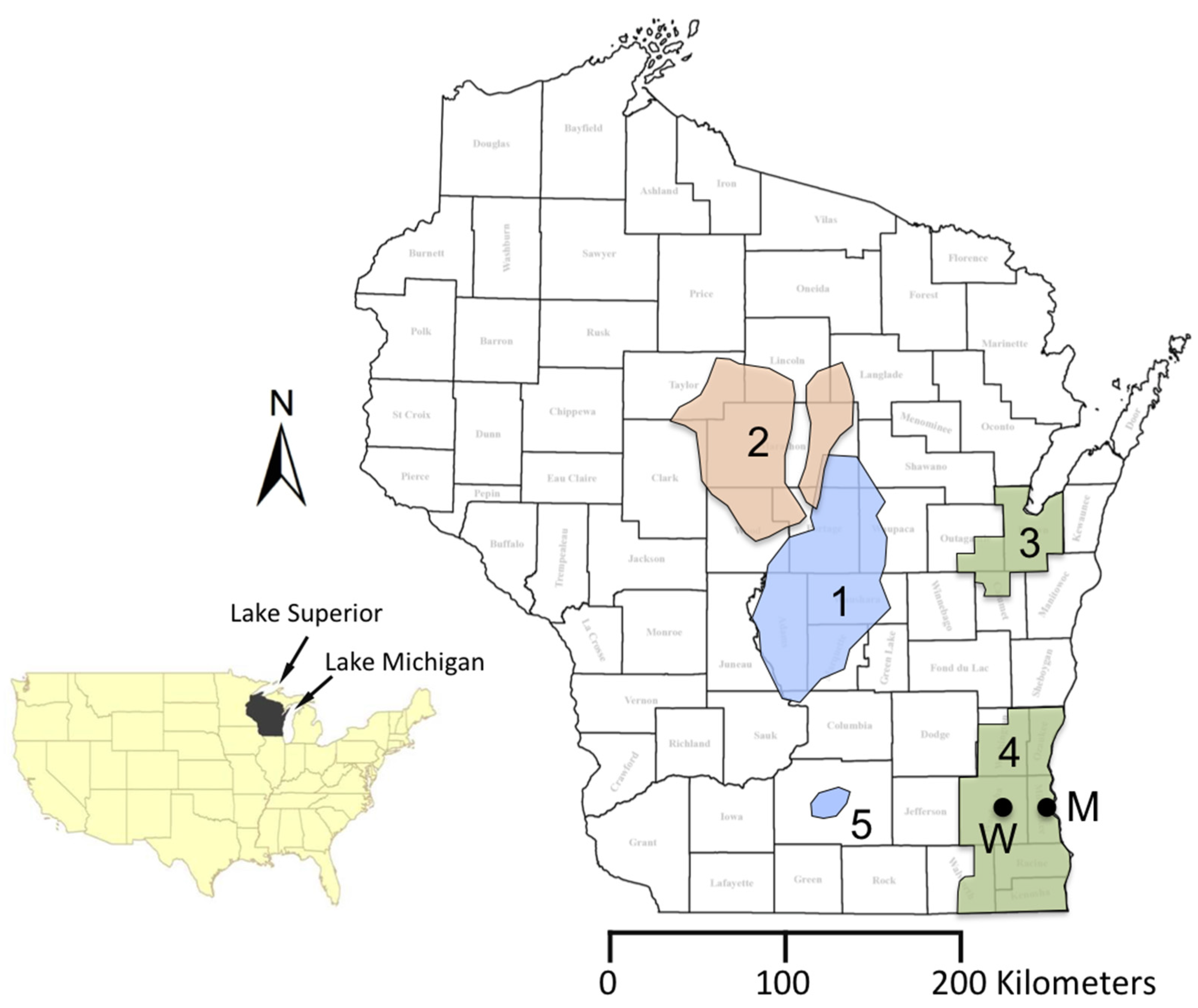
3.2. Groundwater Management Areas in the Confined Sandstone Aquifer
3.3. The Central Sand Plains
3.4. Crystalline Bedrock
3.5. Groundwater Flooding
4. Groundwater Quality Concerns
4.1. Naturally Occurring Inorganic Contaminants
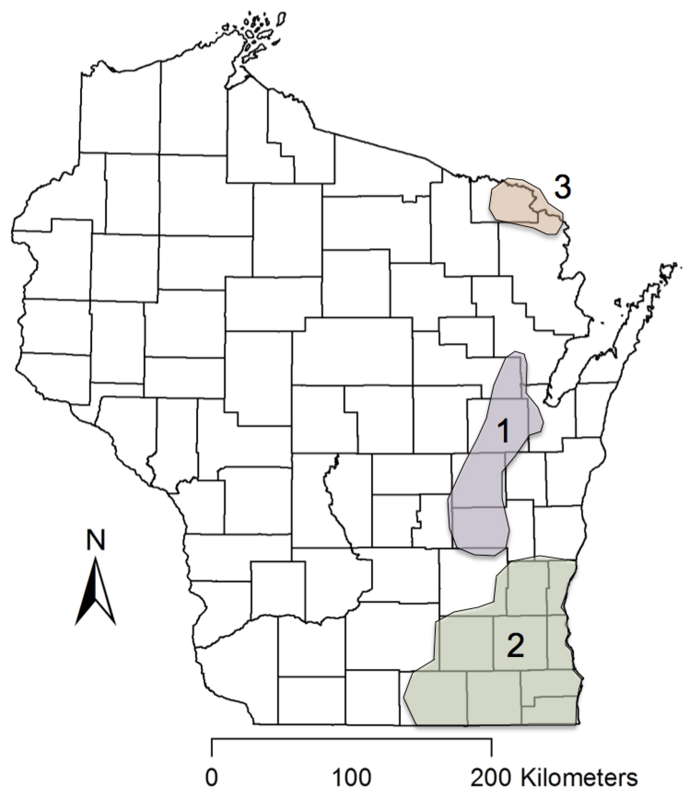
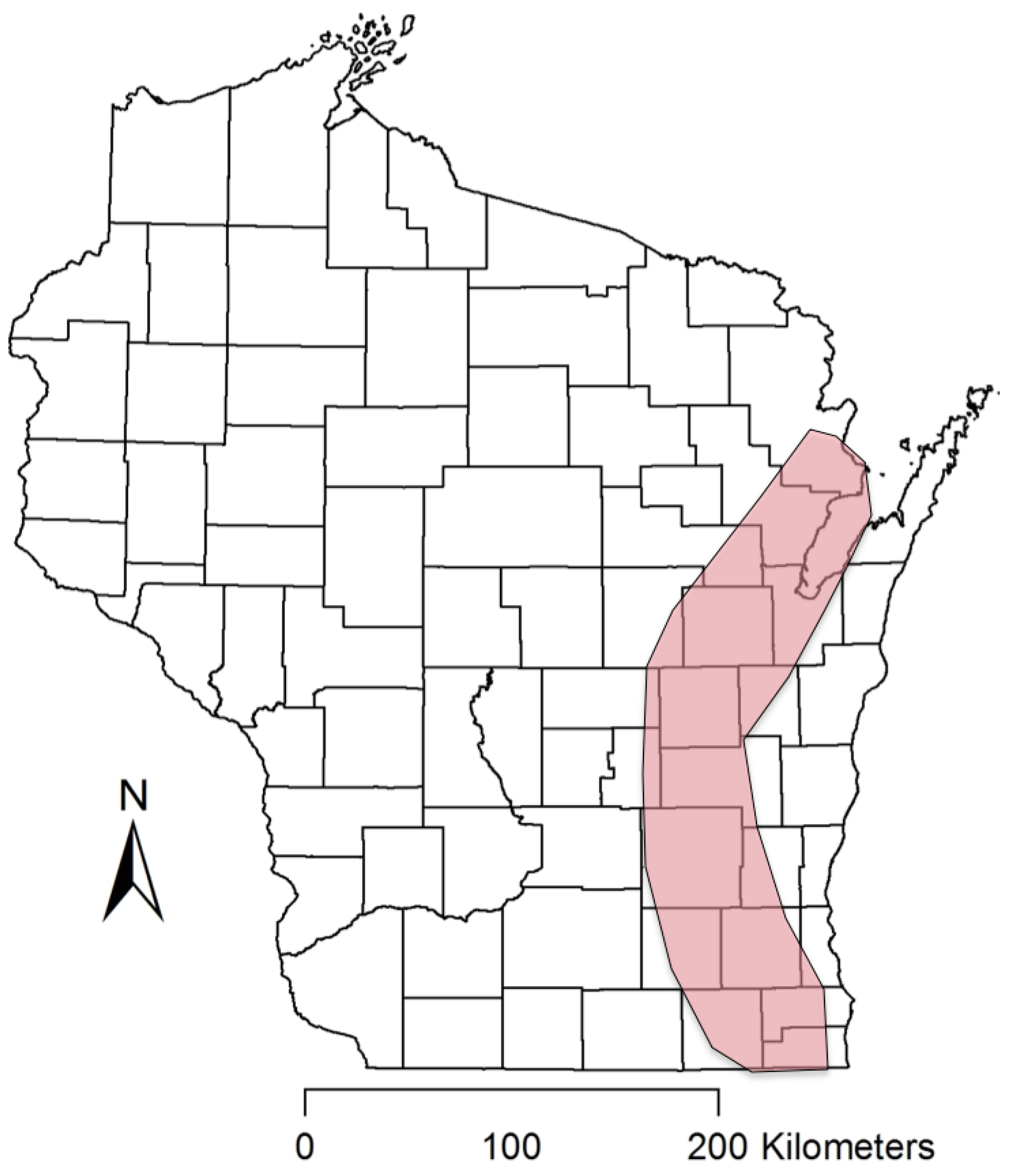
4.1.1. Radium in Sandstone Aquifers of Eastern Wisconsin
4.1.2. Arsenic and Associated Heavy Metals

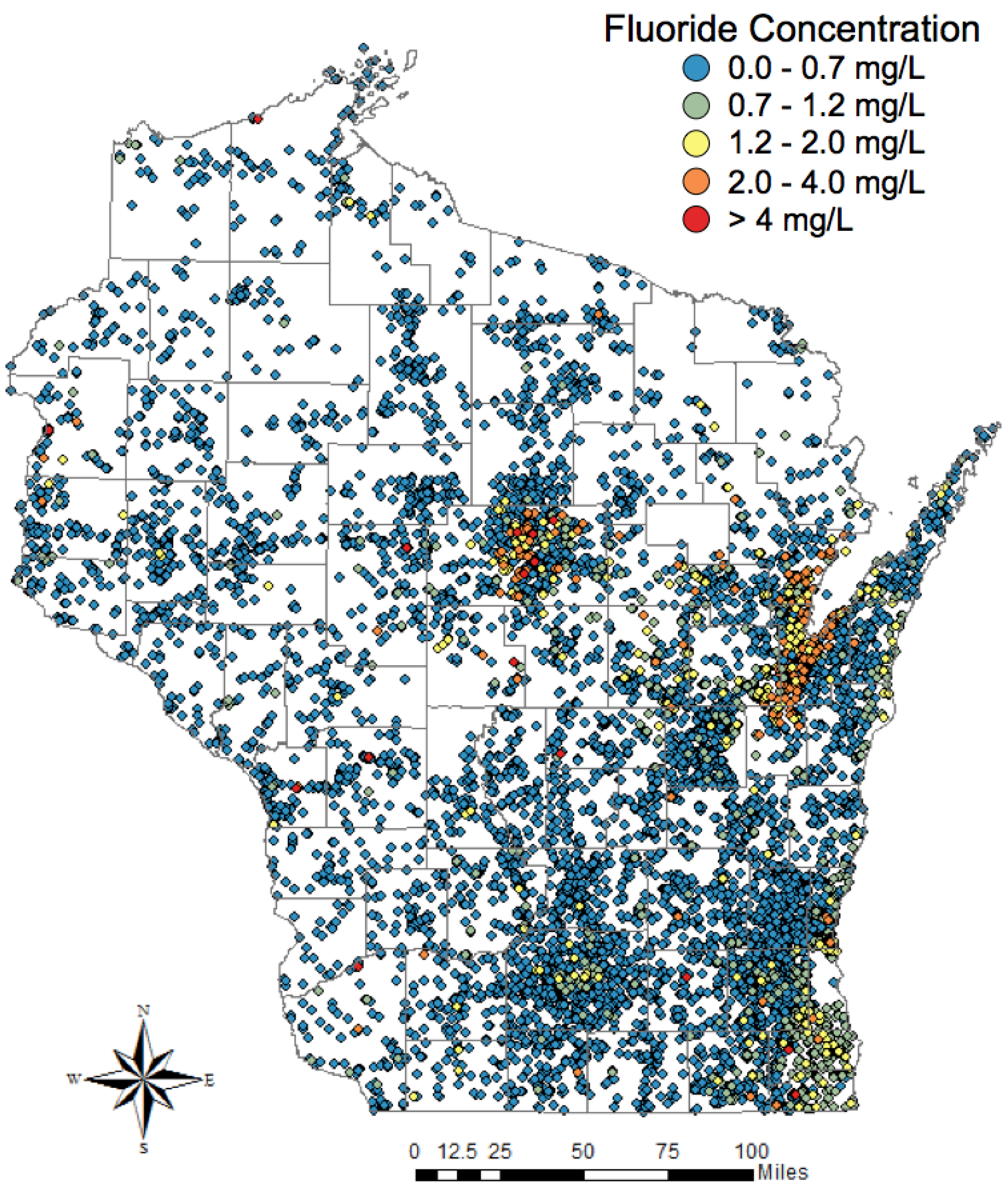
4.1.3. Fluoride Problems in Two Distinct Geologic Provinces
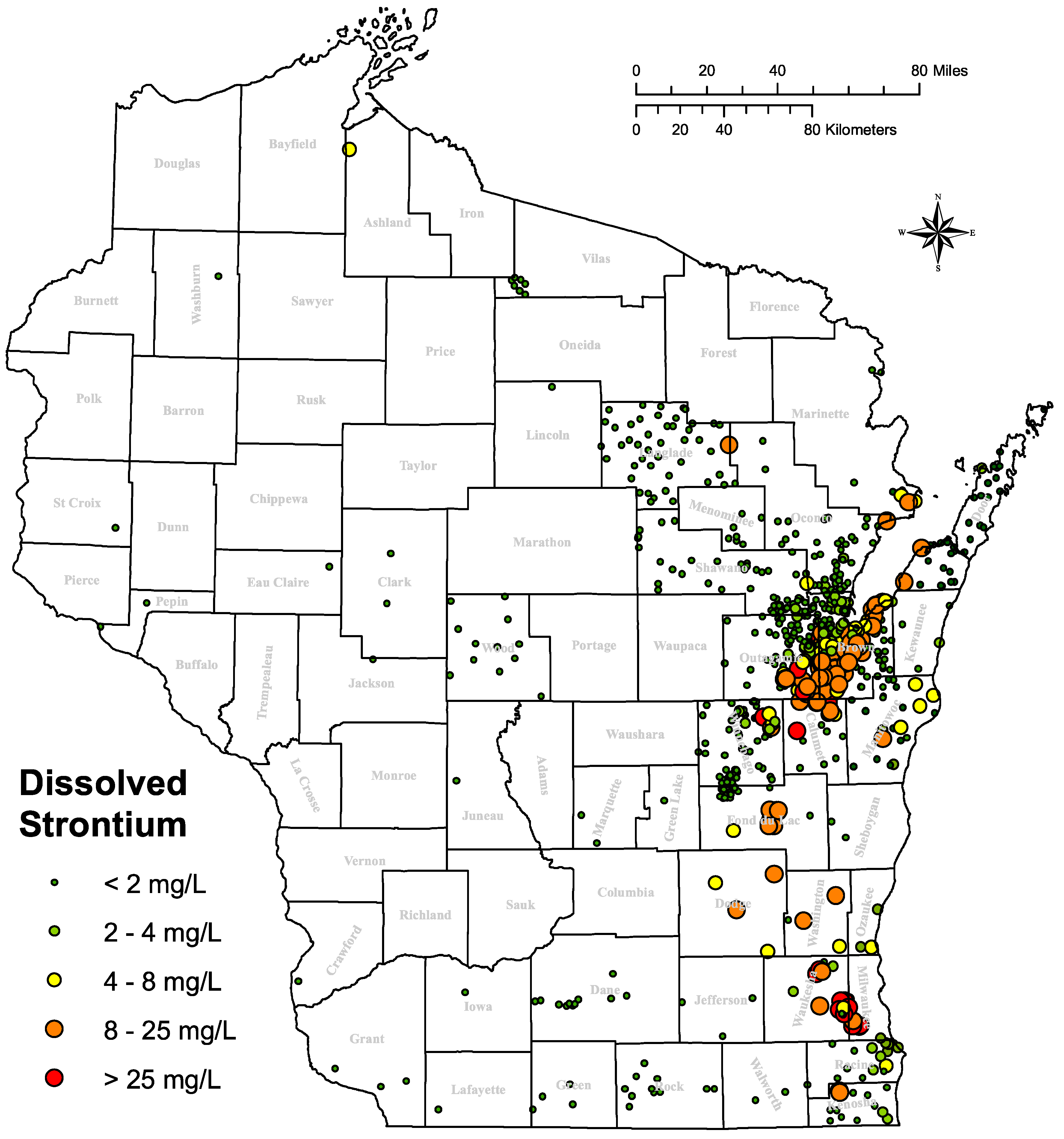
4.1.4. Dissolved Strontium
4.1.5. High Total Dissolved Solids
4.1.6. Other Noteworthy Problems
4.2. Anthropogenic Contaminants
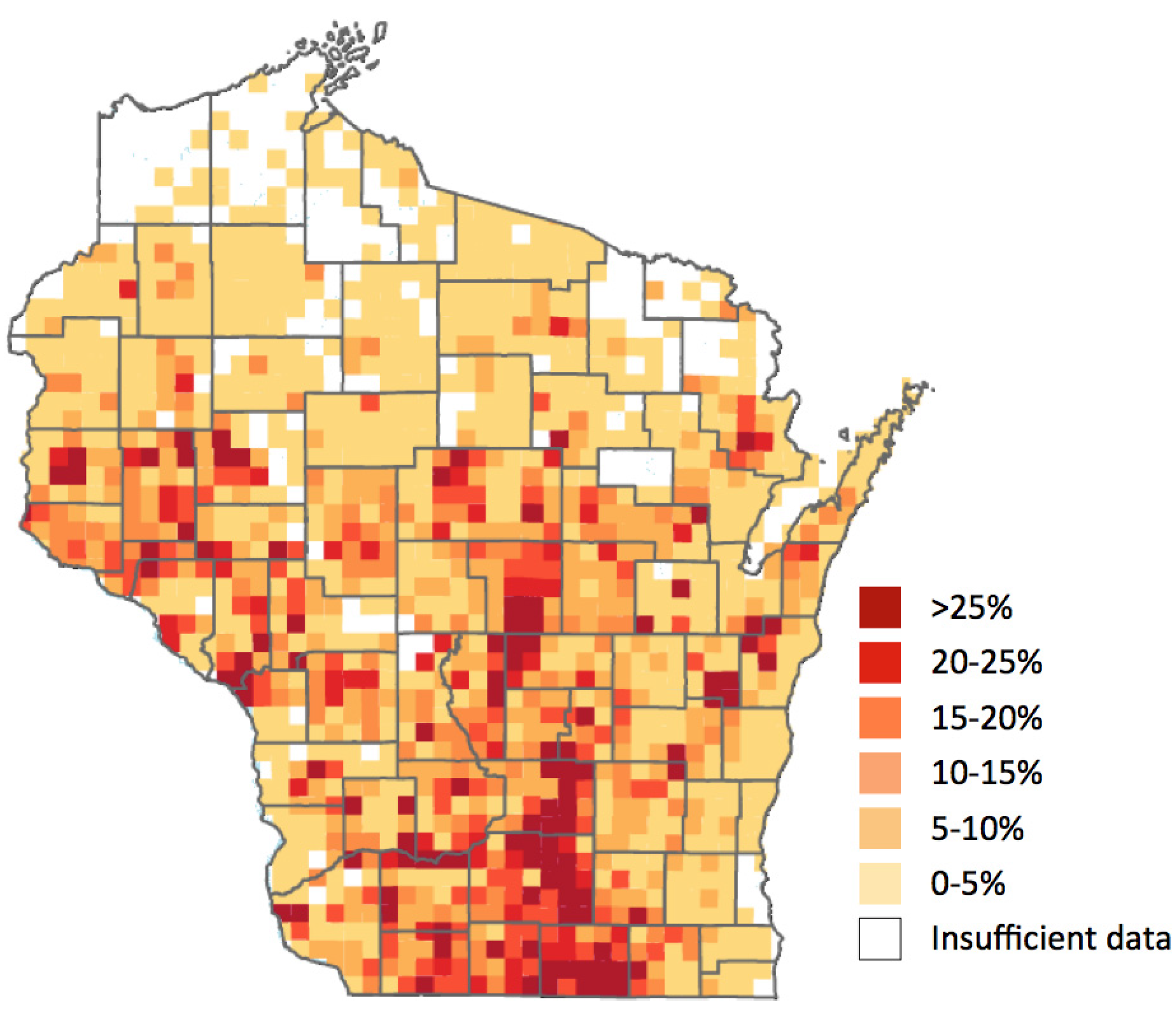
4.2.1. Nitrate

4.2.2. Pathogens
4.2.3. Pesticides
4.2.4. Endocrine Disrupting Compounds
4.3. Contaminants of Unresolved Origin
5. Conclusions
Acknowledgments
Author Contributions
Conflicts of Interest
References
- Rohli, R.V.; Vega, A.J. Climatology, 4th ed.; Jones & Bartlett Learning: Burlington, MA, USA, 2015; p. 443. [Google Scholar]
- NOAA. National Weather Service Statewide Wisconsin Average Annual Precipitation Map—30 Year Average Precipitation 1981–2010. Available online: http://www.crh.noaa.gov/images/mkx/climate/avg_30_year_precip.png (accessed on 15 April 2015).
- United States Census Bureau. United States Census—2010. Available online: http://www.census.gov/2010census/data/ (accessed on 15 April 2015).
- Wisconsin Department of Natural Resources (WDNR). Status of Groundwater Quantity in Wisconsin. Available online: http://dnr.wi.gov/topic/Groundwater/documents/GCC/gw-quantity.pdf (accessed on 15 April 2015).
- Luczaj, J.A.; Hart, D.J. Drawdown in the Northeast Groundwater Management Area (Brown, Outagamie, and Calumet Counties, WI). Final report prepared for the Wisconsin Department of Natural Resources. Available online: http://wgnhs.uwex.edu/pubs/wofr200904/ (accessed on 15 April 2015).
- Maas, J.C. Drawdown, Recovery, and Hydrostratigraphy in Wisconsin’s Northeast Groundwater Management Area (Brown, Outagamie, and Calumet Counties). Master’s Thesis, University of Wisconsin, Green Bay, WI, USA, December 2009. [Google Scholar]
- Southeast Wisconsin Regional Planning Commission (SWRPC). Groundwater Resources of Southeastern Wisconsin: Technical Report Number 37. Available online: http://www.sewrpc.org/SEWRPCFiles/Publications/TechRep/tr-037_groundwater_resources.pdf (accessed on 15 April 2015).
- Stites, W.; Kraft, G.J. Groundwater quality beneath irrigated vegetable fields in a north-central U.S. sand plain. J. Environ. Qual. 2000, 29, 1509–1517. [Google Scholar] [CrossRef]
- Wisconsin Department of Natural Resources (DNR). Wisconsin Lakes; Wisconsin Department of Natural Resources: Madison, WI, USA, 2009.
- Syverson, K.M.; Colgan, P.M. The Quaternary of Wisconsin: A review of stratigraphy and glaciation history. In Quaternary Glaciations—Extent and Chronology, Part II: North America; Ehlers, J., Gibbard, P.L., Eds.; Elsevier Publishing: Amsterdam, The Netherlands, 2004; pp. 295–311. [Google Scholar]
- Wisconsin Department of Natural Resources (WDNR). Wisconsin Water Use: 2013 Withdrawal Summary; Wisconsin Department of Natural Resources Water Use Section: Madison, WI, USA, 2014. Available online: http://dnr.wi.gov/topic/WaterUse/documents/WithdrawalReportDetail.pdf (accessed on 15 April 2015).
- Ellefson, B.R.; Mueller, G.D.; Buchwald, C.A. Water Use in Wisconsin: United States Geological Survey Open-File Report; United States Geological Survey: Reston, VA, USA, 2000.
- Smail, R.A. Written Communication regarding groundwater use in Wisconsin, 13 October 2014.
- Center for Land Use Education (CLUE). Wisconsin Land Use Megatrends: Water. University of Wisconsin-Stevens Point and University of Wisconsin—Cooperative Extension. Available online: https://www.uwsp.edu/cnr-ap/clue/Documents/megatrends/WaterMegatrendsFINAL.pdf (accessed on 15 April 2015).
- Weidman, S.; Schultz, A.R. The Underground and Surface Water Supplies of Wisconsin; Forgotten Books: London, UK, 1915. [Google Scholar]
- Kammerer, P.A., Jr. Ground Water Flow and Quality in Wisconsin’s Shallow Aquifer System; United States Geological Survey: Reston, VA, USA, 1995.
- Dott, R.H., Jr.; Attig, J.W. Roadside Geology of Wisconsin, 1st ed.; Mountain Press: Missoula, MT, USA, 2004; p. 246. [Google Scholar]
- La Berge, G.L. Geology of the Lake Superior Region; Geoscience Press, Inc.: Phoenix, AZ, USA, 1994; p. 313. [Google Scholar]
- Larson, G.; Schaetzl, R. Origin and evolution of the Great Lakes. J. Gr. Lakes Res. 2001, 27, 518–546. [Google Scholar] [CrossRef]
- Luczaj, J.A. Geology of the Niagara escarpment in Wisconsin. Geosci. Wis. 2013, 22, 1–34. Available Online: http://wgnhs.uwex.edu/pubs/gs22a01/ (accessed on 15 April 2015). [Google Scholar]
- Ojakangas, R.W.; Morey, G.B.; Green, J.C. The mesoproterozoic midcontinent rift system, lake superior region, USA. Sediment. Geol. 2001, 141–142, 421–442. [Google Scholar] [CrossRef]
- Schultz, G.M. Wisconsin’s Foundations: A Review of the State’s Geology and its Influence on Geography and Human Activity; UW Press: Dubuque, IA, USA, 1986; pp. 1–211. [Google Scholar]
- Schulz, K.J.; Cannon, W.F. The Penokean orogeny in the Lake Superior region. Precambrian Res. 2007, 157, 4–25. [Google Scholar] [CrossRef]
- Syverson, K.M.; Clayton, L.; Attig, J.W.; Mickelson, D.M. Lexicon of Pleistocene Stratigraphic Units of Wisconsin; Technical Report; Wisconsin Geological and Natural History Survey: Madison, WI, USA, 2011; pp. 1–180. [Google Scholar]
- Catacosinos, P.A.; Daniels, P.A., Jr.; Harrison, W.B., III. Structure, stratigraphy, and petroleum geology of the Michigan basin. In Interior Cratonic Basins; Leighton, M., Kolata, D., Oltz, D., Eidel, J., Eds.; American Association of Petroleum Geologists Memoir: Tulsa, OK, USA, 1990; pp. 561–601. [Google Scholar]
- Luczaj, J.A. Evidence against the Dorag (Mixing-Zone) model for dolomitization along the Wisconsin arch—A case for hydrothermal diagenesis. AAPG Bull. 2006, 90, 1719–1738. [Google Scholar] [CrossRef]
- Runkel, A.C.; Miller, J.F.; McKay, R.M.; Palmer, A.R.; Taylor, J.F. High-resolution sequence stratigraphy of lower Paleozoic sheet sandstones in central North America: The role of special conditions of cratonic interiors in development of stratal architecture. GSA Bull. 2007, 119, 860–881. [Google Scholar] [CrossRef]
- Krohelski, J.T. Hydrogeology and Ground-Water Use and Quality, Brown County, Wisconsin; Wisconsin Geological and Natural History Survey: Madison, WI, USA, 1986; Volume 57, pp. 1–42. [Google Scholar]
- Luczaj, J.A.; Maas, J.; Hart, D.J. A history of drawdown in the Cambrian-Ordovician confined aquifer system in northeastern Wisconsin. Manuscript in preparation.
- Wisconsin Geological & Natural History Survey. In Bedrock Stratigraphic Units in Wisconsin; Educational Series; Wisconsin Geological & Natural History Survey: Madison, WI, USA, 2011.
- McLaughlin, P.I.; Mikulic, D.G.; Kluessendorf, J. Age and correlation of Silurian rocks in Sheboygan, Wisconsin, using integrated stable carbon isotope stratigraphy and facies analysis. Geosci. Wis. 2013, 21, 15–38. [Google Scholar]
- Velbel, M. The “Lost Interval”: Geology from the Permian to the Pliocene. In Michigan Geography and Geology, 1st ed.; Schaetzl, R., Darden, J., Brant, D., Eds.; Pearson Custom Publishing: Boston, MA, USA, 2009; pp. 60–68. [Google Scholar]
- Moran, J.M.; Hopkins, E.J. Wisconsin’s Weather and Climate, 1st ed.; University of Wisconsin Press: Madison, WI, USA, 2002; pp. 1–321. [Google Scholar]
- Thorleifson, L.H. Potential Capacity for Geologic Carbon Sequestration in the Midcontinent Rift System in Minnesota; Open File Report for Minnesota Geological Survey: St. Paul, MN, USA, 2008; pp. 1–138. [Google Scholar]
- Grundl, T.; Cape, M. Geochemical factors controlling radium activity in a sandstone aquifer. Ground Water 2006, 44, 518–527. [Google Scholar] [CrossRef] [PubMed]
- Grundl, T.; Magnusson, N.; Brennwald, M.S.; Kipfer, R. Mechanisms of subglacial groundwater recharge as derived from noble gas, 14C, and stable isotopic data. Earth Planet. Sci. Lett. 2013, 369–370, 78–85. [Google Scholar] [CrossRef]
- Luczaj, J.A.; Stieglitz, R.D. Geologic history of New Hope Cave, Manitowoc County, Wisconsin. Wis. Speleol. 2008, June, 7–17. [Google Scholar]
- Wauters, G.J. Paleoecological Perspectives: The Brussels Hill Pit Cave Mammal Assemblage, with a Focus on Short-Tailed Shrews and Graphical Explorations of Holocene Paleomammalogy in Wisconsin. Master’s Thesis, University of Wisconsin, Green Bay, WI, USA, 2013. [Google Scholar]
- Weaver, T.R.; Bahr, J.M. Geochemical evolution in the Cambrian-Ordovician sandstone aquifer, eastern Wisconsin: 1. Major ion and radionuclide distribution. Ground Water 1991, 29, 350–356. [Google Scholar] [CrossRef]
- Weaver, T.R.; Bahr, J.M. Geochemical evolution in the Cambrian-Ordovician sandstone aquifer, eastern Wisconsin. 2. Correlation between flow paths and ground-water chemistry. Ground Water 1991, 29, 510–515. [Google Scholar] [CrossRef]
- Klump, S.; Grundl, T.; Purtschert, R.; Kipfer, R. Groundwater and climate dynamics derived from noble gas, 14C, and stable isotope data. Geology 2008, 36, 395–398. [Google Scholar] [CrossRef]
- Weeks, E.P.; Stangland, H.G. Effects of Irrigation on Streamflow in the Central Sand Plain of Wisconsin; United States Geological Survey: Reston, VA, USA, 1971.
- Kraft, G.J.; Clancy, K.; Mechenich, D.J.; Haucke, J. Irrigation effects in the Northern Lake States: Wisconsin central sands revisited. Ground Water 2012, 50, 308–318. [Google Scholar] [CrossRef] [PubMed]
- Groundwater Coordinating Council (GCC). Wisconsin Groundwater Coordinating Council FY 2013 Report to the Wisconsin State Legislature. Available online: http://dnr.wi.gov/topic/groundwater/documents/GCC/Report/WIgroundwaterLaw.PDF (accessed on 15 April 2015).
- Supreme Court of Wisconsin, Lake Beulah Management District, Petitioner-Appellant-Cross-Respondent, Lake Beulah Protective and Improvement Association, Co-Petitioner-Co-Appellant-Cross- Respondent, v. State of Wisconsin Department of Natural Resources, Respondent-Respondent, Village of East Troy, Intervening-Respondent-Respondent- Cross-Appellant-Petitioner. 2011. Available online: https://www.wicourts.gov/sc/opinion/DisplayDocument.pdf?content=pdf&seqNo=67353 (accessed on 15 April 2015).
- Boldt, J.D. Case Nos. 1H-12-03, 1H-12-05, DNR-13-021 and NDR-13-027. State of Wisconsin, Division of Hearings and Appeals. 3 September 2014. [Google Scholar]
- Council of Great Lakes Governors. Great Lakes-St. Lawrence River Basin Water Resources Compact (2008). Available online: http://www.cglg.org/projects/water-management/great-lakes-agreement-and-compact/ (accessed on 12 April 2015).
- Karkkainen, B.C. The Great Lakes water resources compact and agreement: Transboundary normativity without international law. William Mitchell Law Rev. 2013, 39, 997. [Google Scholar]
- Feinstein, D.T.; Hart, D.J.; Eaton, T.T.; Krohelski, J.T.; Bradbury, K.R. Simulation of Regional Groundwater Flow in Southeastern Wisconsin; Wisconsin Geological & Natural History Survey: Madison, WI, USA, 2004; Available online: http://wgnhs.uwex.edu/pubs/wofr200401/ (accessed on 15 April 2015).
- Luczaj, J.A. The largest flowing artesian well in the state of Wisconsin is (sometimes) an abandoned deep quarry. In Proceedings of the American Water Resources Association—Wisconsin Section, 38th Annual Meeting, Wisconsin Dells, WI, USA, 13–14 March 2014; Available online: http://state.awra.org/wisconsin/2014meeting/Session3A4Luczaj.pdf (accessed on 15 April 2015).
- Jakel, D.E. Soil Survey of Adams County, Wisconsin; USDA Soil Conservation Service: Washington, DC, USA, 1980.
- Weeks, E.P.; Ericson, D.W.; Holt, C.L.R. Hydrology of the Little Plover River Basin Portage County, Wisconsin and the Effects of Water Resource Development; Water-Supply Paper for United States Geological Survey; United States Geological Survey: Reston, VA, USA, 1965.
- Clayton, L. Pleistocene Geology of Adams County, Wisconsin; University of Wisconsin-Extension and Geological and Natural History Survey: Madison, WI, USA, 1987. [Google Scholar]
- Goc, M.J. The Wisconsin Dust Bowl. Wis. Mag. Hist. 1990, 73, 163–201. [Google Scholar]
- Prengaman, K. Groundwater War Pits Farmers Against Fish. Wisconsin Center for Investigative Journalism, 13 July 2013. Available online: http://wisconsinwatch.org/2013/07/groundwater-war-pits-wisconsin-farms-against-fish-2/ (accessed on 15 April 2015).
- Wisconsin Department of Natural Resources (WDNR). Central Sands Strategic Analysis. Available online: http://dnr.wi.gov/topic/eia/cssa.html (accessed on 13 April 2015).
- Bell, E.A.; Sherrill, M.G. Water Availability in Central Wisconsin—An Area of Near-Surface Crystalline Rock; Water-Supply Paper for United States Geological Survey: Reston, VA, USA, 1974.
- Joachim, D.R.; Gotkowitz, M.B.; Potter, K.W.; Bradbury, K.R.; Vavrus, S.J.; Loheide, S.P. Forecasting Impacts of Extreme Precipitation Events on Wisconsin’s Groundwater Levels; Open-File Report; Wisconsin Geological & Natural History Survey: Madison, WI, USA, 2011; Available online: http://wgnhs.uwex.edu/pubs/000897/ (accessed on 15 April 2015).
- Knobeloch, L.; Gorski, P.; Christenson, M. Private drinking water quality in rural Wisconsin. J. Environ. Health 2013, 75, 16–20. [Google Scholar] [PubMed]
- WHO. Guidelines for Drinking Water Quality, 4th ed.; World Health Organization: Geneva, Switzerland, 2011. [Google Scholar]
- U.S. Environmental Protection Agency. National Primary Drinking Water Standards; Environmental Protection Agency: Washington, DC, USA, 2000; pp. 76708–76753.
- Guse, C.E.; Marbbella, A.M.; George, V.; Layde, P.M. Radium in Wisconsin drinking water: An analysis of osteosarcoma risk. Arch. Environ. Health 2002, 57, 294–303. [Google Scholar] [CrossRef] [PubMed]
- Gilkeson, R.H.; Cowart, J.B. Radium, radon, and uranium isotopes in ground water from Cambrian–Ordovician sandstone aquifers in Illinois. In Radon in Ground Water—Hydrogeologic Impact and Indoor Air Contamination; Graves, B., Ed.; Lewis Publishers, Inc.: Chelsea, MI, USA, 1987; pp. 403–422. [Google Scholar]
- Wilson, J.T. Water-Quality Assessment of the Cambrian-Ordovician Aquifer System in the Northern Midwest, United States; Scientific Investigations Report; United States Geological Survey: Reston, VA, USA, 2012. Available online: http://pubs.usgs.gov/sir/2011/5229 (accessed on 15 April 2015).
- Wisconsin Department of Natural Resources (WDNR). Radium in Drinking Water. PUB-DG-008 2014. Available online: http://dnr.wi.gov/files/pdf/pubs/dg/dg0008.pdf (accessed on 15 April 2015).
- Sturchio, N.C.; Banner, J.L.; BInz, C.M.; Heraty, L.B.; Musgrove, M. Radium geochemistry of ground waters in Paleozoic carbonate aquifers, midcontinent, USA. Appl. Geochem. 2001, 16, 109–122. [Google Scholar] [CrossRef]
- Gilkeson, R.H.; Cartwright, K.; Cowart, J.B.; Holtzman, R.B. Hydrogeologic and Geochemical Studies of Selected Natural Radioisotopes and Barium in Ground Water in Illinois; Report for Illinois Water Resources Center: Urbana, IL, USA, 1983; pp. 1–93.
- Siegel, D.I. Sulfur isotope evidence for regional recharge of saline water during continental glaciation, north-central United States. Geology 1990, 18, 1054–1056. [Google Scholar] [CrossRef]
- Millard, P. Brown County Cities Find Water Crisis Solution in Manitowoc County. Available online: http://www.bizjournals.com/milwaukee/stories/2007/12/10/focus1.html?page=all (accessed on 15 April 2015).
- Bergquist, L. Fond du Lac to Pay Settlement over Radium in Drinking Water. Available online: http://www.jsonline.com/news/wisconsin/37527669.html (accessed on 15 April 2015).
- Wisconsin Department of Natural Resources (DNR). DNR Approves New Berlin Request to Divert Lake Michigan Water; Department of Natural Resources: Madison, WI, USA, 21 May 2009.
- Behm, D. Waukesha Turns to More Radium-Laced Water after Well Pump Fails. Available online: http://www.jsonline.com/news/waukesha/waukesha-turns-to-radium-contaminated-water-after-well-pump-fails-b99108416z1-225570262.html (accessed on 15 April 2015).
- Waukesha Water Utility Public Radium Notice. Letter to the Public (2014). Available online: http://www.ci.waukesha.wi.us/web/guest/redium (accessed on 15 May 2015).
- Behm, D. Waukesha Concedes it Can’t Meet Deadline for Radium-Free Water. Milwaukee Journal Sentinel. 19 November 2014. Available online: http://www.jsonline.com/news/waukesha/waukesha-concedes-it-can-meet-deadline-for-radium-free-water-b99393845z1–283255831.html (accessed on 15 April 2015).
- Smith, A.H.; Lingas, E.O.; Rahman, M. Contamination of drinking-water by arsenic in Bangladesh: A public health emergency. Bull. World Health Organ. 2000, 78, 1093–1103. [Google Scholar] [PubMed]
- Riewe, T.; Weissbach, A.; Heinen, L.; Stoll, R. Naturally occurring arsenic in well water in Wisconsin. Water Well J. 2000, 49, 24–29. [Google Scholar]
- Knobeloch, L.M.; Zierold, K.M.; Anderson, H.A. Association of arsenic-contaminated drinking-water with prevalence of skin cancer in Wisconsin’s Fox River valley. J. Health Popul. Nutr. 2006, 24, 206–213. [Google Scholar] [PubMed]
- Schreiber, M.E.; Simo, J.A.; Freiberg, P.G. Stratigraphic and geochemical controls on naturally occurring arsenic in groundwater, Eastern Wisconsin, USA. Hydrogeol. J. 2000, 8, 161–176. [Google Scholar] [CrossRef]
- Center for Watershed Science and Education (CWSE). WI Well Water Viewer, University of Wisconsin-Stevens Point. Available online: http://www.uwsp.edu/cnr-ap/watershed/Pages/WellWaterViewer.aspx (accessed on 13 April 2015).
- Root, T.L.; Gotkowitz, M.B.; Bahr, J.M.; Attig, J.W. Arsenic geochemistry and hydrostratigraphy in Midwestern U.S. glacial deposits. Ground Water 2010, 48, 903–912. [Google Scholar] [CrossRef] [PubMed]
- Johnson, D.M.; Riewe, T. Arsenic and Northeastern Wisconsin. Water Well J. 2006, 60, 26–31. [Google Scholar]
- Burkel, R.S.; Stoll, R.C. Naturally occurring arsenic in sandstone aquifer water supply wells of Northeastern Wisconsin. Groundw. Monit. Remediat. 1999, 19, 114–121. [Google Scholar] [CrossRef]
- Schreiber, M.E.; Gotkowitz, M.B.; Simo, J.A.; Freiberg, P.G. Mechanisms of arsenic release to ground water from naturally occurring sources, eastern Wisconsin. In Arsenic in Ground Water; Welch, A., Stollenwerk, K., Eds.; Kluwer Academic Publishers: Boston, MA, USA, 2003; pp. 259–280. [Google Scholar]
- Gotkowitz, M.B.; Schreiber, M.S.; Simo, J.A. Effects of water use on arsenic release to well water in a confined aquifer. Ground Water 2004, 42, 568–575. [Google Scholar] [CrossRef] [PubMed]
- Johnson, D. Written communication, 28 August 2008.
- Luczaj, J.A.; McIntire, M. Geochemical characterization of MVT mineralization in eastern Wisconsin Paleozoic sedimentary rocks: Implications for groundwater quality. Manuscript in preparation.
- Thornburg, K.; Sahai, N. Arsenic occurrence, mobility, and retardation in sandstone and dolomite formations of the Fox River Valley, Eastern Wisconsin. Environ. Sci. Technol. 2004, 38, 5087–5094. [Google Scholar] [CrossRef] [PubMed]
- Ozsvath, D.L. Fluoride and environmental health: A review. Rev. Environ. Sci. Biotechnol. 2009, 8, 59–79. [Google Scholar] [CrossRef]
- Tiemann, M. Fluoride in Drinking Water: A Review of Fluoridation and Regulation Issues; Congressional Research Service: Washington, DC, USA, 2013; pp. 1–21. [Google Scholar]
- Ozsvath, D.L. Fluoride concentrations in a crystalline bedrock aquifer Marathon County, Wisconsin. Environ. Geol. 2006, 50, 132–138. [Google Scholar] [CrossRef]
- Wisconsin Department of Natural Resources (WDNR). Groundwater Retrieval Network. Available online: http://prodoasext.dnr.wi.gov/inter1/grn$.startup (accessed on 20 October 2014).
- Luczaj, J.A.; Zorn, M.; Baeten, J. An Evaluation of the Distribution and Sources of Dissolved Strontium in the Groundwater of Eastern Wisconsin, with a Focus on Brown and Outagamie Counties; Final Report Submitted to the UW Water Resources Institute: Madison, WI, USA, 15 November 2013. [Google Scholar]
- Baeten, J. Spatial Distribution and Source Identification of Dissolved Strontium in Eastern Wisconsin’s Cambrian-Ordovician Aquifers. Master’s Thesis, University of Wisconsin, Green Bay, WI, USA, 2013. [Google Scholar]
- Luczaj, J.A.; Baeten, J.; Zorn, M. Distribution and Sources of Dissolved Strontium in the Groundwater of Eastern Wisconsin. Manuscript in preparation.
- Holt, C.; Skinner, E.L. Ground-water quality in Wisconsin through 1972. Wis. Geol. Nat. Hist. Surv. Inform. Circular 1973, 22, 1–148. [Google Scholar]
- Nichols, M.S.; McNall, D.R. Strontium content of Wisconsin municipal waters. J. Am. Water Works Assoc. 1957, 49, 1493–1498. [Google Scholar]
- Özgür, S.; Sümer, H.; Koҫoǧlu, G. Rickets and soil strontium. Arch. Dis. Child. 1996, 75, 524–526. [Google Scholar] [CrossRef] [PubMed]
- Curzon, M.E.J.; Spector, P.C. Enamel mottling in a high strontium area of the USA. Community Dent. Oral Epidemiol. 1977, 5, 243–247. [Google Scholar] [CrossRef] [PubMed]
- Available online: http://yosemite.epa.gov/opa/admpress.nsf/6427a6b7538955c585257359003f0230/327f339e63facb5a85257d77005f4bf9!OpenDocument (accessed on 15 April 2015).
- Bethke, C.M.; Marshak, S. Brine migrations across North America—The plate tectonics of groundwater. Annu. Rev. Earth Planet. Sci. 1990, 18, 237–315. [Google Scholar] [CrossRef]
- Klimas, A.; Mališauskas, A. Boron, fluoride, strontium, and lithium anomalies in fresh groundwater of Lithuania. Geologija 2008, 50, 114–124. [Google Scholar] [CrossRef]
- Oberle, S. Written communication, 22 June 2011.
- Shaw, B. Nitrogen contamination sources: A look at relative contributions. In Proceedings of the Nitrate in Wisconsin’s Groundwater: Strategies and Challenges Conference, Stevens Point, WI, USA, 10 May 1994.
- Department of Agriculture, Trade and Consumer Protection (DATCP). Agricultural Chemicals in Wisconsin Groundwater (April 2008). Available online: http://datcp.wi.gov/uploads/Environment/pdf/ARMPub180.pdf (accessed on 15 April 2015).
- Schmidt, R.R. Groundwater Contamination Susceptibility Map and Evaluation; Wisconsin’s Groundwater Management Plan Report; Wisconsin Department of Natural Resources: Madison, WI, USA, 1987.
- Masarik, K.; Norman, J.; Brye, K. Long-term drainage and nitrate leaching below well-drained continuous corn agroecosystems and a prairie. J. Environ. Prot 2014, 5, 240–254. [Google Scholar] [CrossRef]
- Randall, G.W.; Huggins, D.R.; Russelle, M.P.; Fuchs, D.J.; Nelson, W.W.; Anderson, J.L. Nitrate losses through subsurface tile drainage in conservation reserve program, alfalfa, and row crop systems. J. Environ. Qual. 1997, 26, 1240–1247. [Google Scholar] [CrossRef]
- Erb, K.R.; Stieglitz, R. Final Report of the Northeast Wisconsin Karst Task Force; University of Wisconsin—Extension: Madison, WI, USA, 2007; pp. 1–46. [Google Scholar]
- Bauer, A.C.; Wingert, S.; Fermanich, K.J.; Zorn, M.E. Well water in karst regions of northeastern Wisconsin contains estrogenic factors, nitrate, and bacteria. Water Environ. Res. 2013, 85, 318–326. [Google Scholar] [CrossRef] [PubMed]
- Borchardt, M.A.; Bertz, P.D.; Spencer, S.K.; Battigelli, D.A. Incidence of enteric viruses in groundwater from household wells in Wisconsin. Appl. Environ. Microbiol. 2003, 69, 1172–1180. [Google Scholar] [CrossRef] [PubMed]
- Borchardt, M.A.; Haas, N.L.; Hunt, R.J. Vulnerability of drinking-water wells in La Crosse, Wisconsin, to enteric-virus contamination from surface water contributions. Appl. Environ. Microbiol. 2004, 70, 5937–5946. [Google Scholar] [CrossRef] [PubMed]
- Borchardt, M.A.; Bradbury, K.R.; Gotkowitz, M.B.; Cherry, J.A.; Parker, B.L. Human enteric viruses in groundwater from a confined bedrock aquifer. Environ. Sci. Technol. 2007, 41, 6606–6612. [Google Scholar] [CrossRef] [PubMed]
- Hunt, R.J.; Borchardt, M.A.; Richards, K.D.; Spencer, S.K. Assessment of sewer source contamination in drinking water wells using tracers and human enteric viruses. Environ. Sci. Technol. 2010, 44, 7956–7963. [Google Scholar] [CrossRef] [PubMed]
- Borchardt, M.A.; Bradbury, K.R.; Alexander, E.C., Jr.; Kolberg, R.J.; Alexander, S.C.; Archer, J.R.; Braatz, L.A.; Forest, B.M.; Green, J.A.; Spencer, S.K. Norovirus outbreak caused by a new septic system in a dolomite aquifer. Ground Water 2011, 49, 85–97. [Google Scholar] [CrossRef] [PubMed]
- Borchardt, M.A.; Spencer, S.K.; Kieke, B.A.; Lambertini, E.; Loge, F.J. Viruses in non-disinfected drinking water from municipal wells and community incidence of acute gastrointestinal illness. Environ. Health Perspect. 2012, 120, 1272–1279. [Google Scholar] [CrossRef] [PubMed]
- Uejio, C.K.; Yale, S.H.; Malecki, K.; Borchardt, M.A.; Anderson, H.A.; Patz, J.A. Drinking water systems, hydrology, and childhood gastrointestinal illness in central and Northern Wisconsin. Am. J. Public Health 2014, 104, 639–646. [Google Scholar] [CrossRef] [PubMed]
- Erb, K.R.; Ronk, E. Documenting the regional impacts of karst task force recommendations on ‘brown water incidents’ in Northeast Wisconsin, USA. Resources 2015. under review. [Google Scholar]
- Chern, L. Written communication, 8 April 2014.
- Gotkowitz, M.B.; Liebl, D.S. Municipal drinking water safety, the link between groundwater, pathogens, and public health. Wis. Geol. Nat. Hist. Surv. Educ. Ser. 2013, 053, 1–4. [Google Scholar]
- Wisconsin Department of Agriculture, Trade, and Consumer Protection. Wisconsin groundwater quality: Agricultural chemicals in Wisconsin groundwater. In Agric. Resour. Manag.; 2008; 180, p. 21. Available online: http://datcp.wi.gov/uploads/Environment/pdf/ARMPub180.pdf (accessed on 15 April 2015). [Google Scholar]
- Wisconsin Department of Agriculture, Trade, and Consumer Protection. Fifteen Years of the DATCP Exceedence Well Survey 2010. Available online: http://datcp.wi.gov/uploads/Environment/pdf/FifteenYearsoftheDATCPExceedenceSurvey.pdf (accessed on 15 April 2015).
- Benotti, M.J.; Trenholm, R.A.; Vanderford, B.J.; Holady, J.C.; Stanford, B.D.; Snyder, S.A. Pharmaceuticals and endocrine disrupting compounds in U.S. drinking water. Environ. Sci. Techol. 2009, 43, 597–603. [Google Scholar] [CrossRef]
- Cook, T.; Mathewson, P.; Nekola, K. Don’t Drink the Water—Groundwater Contamination and the “Beneficial Reuse” of Coal Ash in Southeast Wisconsin. Clean Wisconsin, (November 2014). Available online: http://www.cleanwisconsin.org/wp-content/uploads/2015/02/dont-drink-the-water-report-clean-wisconsin.pdf (accessed on 15 April 2015).
- Lourigan, J.; Phelps, W. Caledonia groundwater molybdenum investigation Southeast Wisconsin—2013. Wisconsin Department of Natural Resources: Madison, WI, USA, 2013. Available online: http://dnr.wi.gov/files/PDF/pubs/WA/WA1625.pdf (accessed on 15 April 2015). [Google Scholar]
- United States Environmental Protection Agency (USEPA). Hazardous and Solid Waste Management System; Disposal of Coal Combustion Residuals from Electric Utilities. Available online: http://www.gpo.gov/fdsys/pkg/FR-2015-04-17/pdf/2015-00257.pdf (accessed on 15 April 2015).
© 2015 by the authors; licensee MDPI, Basel, Switzerland. This article is an open access article distributed under the terms and conditions of the Creative Commons Attribution license (http://creativecommons.org/licenses/by/4.0/).
Share and Cite
Luczaj, J.; Masarik, K. Groundwater Quantity and Quality Issues in a Water-Rich Region: Examples from Wisconsin, USA. Resources 2015, 4, 323-357. https://doi.org/10.3390/resources4020323
Luczaj J, Masarik K. Groundwater Quantity and Quality Issues in a Water-Rich Region: Examples from Wisconsin, USA. Resources. 2015; 4(2):323-357. https://doi.org/10.3390/resources4020323
Chicago/Turabian StyleLuczaj, John, and Kevin Masarik. 2015. "Groundwater Quantity and Quality Issues in a Water-Rich Region: Examples from Wisconsin, USA" Resources 4, no. 2: 323-357. https://doi.org/10.3390/resources4020323
APA StyleLuczaj, J., & Masarik, K. (2015). Groundwater Quantity and Quality Issues in a Water-Rich Region: Examples from Wisconsin, USA. Resources, 4(2), 323-357. https://doi.org/10.3390/resources4020323