Article

Geosites in the Gole della Breggia Geopark, Ticino, Southern Switzerland

1
Geolog.ch SA, 6872 Mendrisio, Switzerland
2
Department of Human and Innovation Sciences, Insubria University, 21100 Como, Italy
3
Cantonal Museum of Natural History, 6900 Lugano, Switzerland
4
Gole della Breggia Geopark, 6834 Morbio Inferiore, Switzerland
5
Department of Earth and Environmental Sciences, University of Milano-Bicocca, 20126 Milan, Italy
6
CRUST-Interuniversity Center for 3D Seismotectonics with Territorial Applications, 66100 Chieti Scalo, Italy
*
Author to whom correspondence should be addressed.
Resources 2023, 12(10), 122; https://doi.org/10.3390/resources12100122
Submission received: 26 August 2023 / Revised: 6 October 2023 / Accepted: 9 October 2023 / Published: 12 October 2023
(This article belongs to the Special Issue Geosites as Tools for the Promotion and Conservation of Geoheritage)

Abstract

:
This work is aimed at illustrating one of the most engaging geoparks in Europe, the Gole della Breggia Geopark. By following its geotrail, the visitors can observe a great deal of features that encompass a wide variety of sedimentary, stratigraphic, tectonic and paleogeographic processes. Its contents are popularized by a comprehensive geotrail that encompasses 23 geostops, enriched with explanatory panels, which enable viewers to gain an overall picture of the complex processes that led to the present-day configuration of the outcrops encountered in the geopark. We have selected five significative outcrops, which we have regarded as fully-fledged geosites, and which encompass the whole 170-million-year interval, from Early Jurassic to Late Miocene times, during which the rocks of the geopark were deposited and deformed. We have performed an assessment of the five geosites, using the most common criteria that can be applied for geosite evaluation. The results of the assessment show that the most valuable geosites are the Lombardian Maiolica, and the Limestone with Pelagic Bivalves. All five geosites, thanks to a QR code added to each figure along the text, can be viewed as virtual geosites (VGs), integrated by 360° videos.

1. Introduction

1.1. Geoheritage and Geosites

Geoheritage, which incorporates aspects of geodiversity, has been documented by a great deal of papers over the last 30 years (e.g., [1,2,3,4,5,6,7,8,9]). It has major scientific, cultural and educational relevance and these qualities make it worthy of popularization in Earth Science museums [10,11,12,13] and of protection in geoparks [14,15,16,17,18,19,20,21,22,23]; moreover, geoheritage can be crucial for geotouristic purposes [24,25,26,27,28,29,30,31,32,33,34,35]. Safeguarding geoheritage means preserving specific geomorphological and geological features, which are named geosites. These are natural elements that reflect the geological heritage of a place [36,37,38,39] and are marked by a number of values. They can have paleontological [40], petrological, volcanic [41,42,43], tectonic [44,45] mineralogical [46], stratigraphic, igneous [47], climate-related, paleogeographic, petrographic [48], sedimentary and geomorphological relevance. They can be located in natural or artificial/anthropized areas. In a recent paper [49], it has been underscored that the definition of a geosite has to be considered equivalent to a major outreach effort, which should be based on an in-depth knowledge of the geological meaning of the geosite itself. It is worth underscoring that geosites can also be geomorphological elements, which compose geomorpho-diversity [50] and, therefore, are known as geomorphosites [51].

1.2. The Fundamentals of Geosite Assessment

Over the last couple of decades, a great number of authors have attempted to assess the quality of geosites, both in a qualitative and a quantitative way. This assessment has been made by employing a range of criteria. One of the most used criteria is the scientific relevance of a geosite, known as “scientific value” [52]; this, in turn, is composed of four sub-criteria, which are integrity, representativeness, rarity [53,54] and how much a given geosite has been the subject of scientific publications. As regards representativeness, this is related to how much a geosite is exemplary if we consider the extent of the natural processes that occurred there. Rarity, on the other hand, expresses how a geosite is uncommon at the local, regional or worldwide level. Along with the scientific value, there are other values that are called “additional values” [55,56] and can become subject to assessment. These additional values are ecological, cultural, aesthetic, educational and touristic. The most relevant is the educational value [57], which reflects the combination of the didactic potential of the geosite (pertaining to how well the lay public can grasp the meaning of its features) with its accessibility, safety, as well as its possible usefulness for educational purposes—for example, in terms of the possibility to organize guided tours to access and view the geosites. It is worth noting that other important papers that have dealt with geosite assessment are those by Bruschi et al. [58], Reynard et al. [59], Suzuki and Takagi [60].

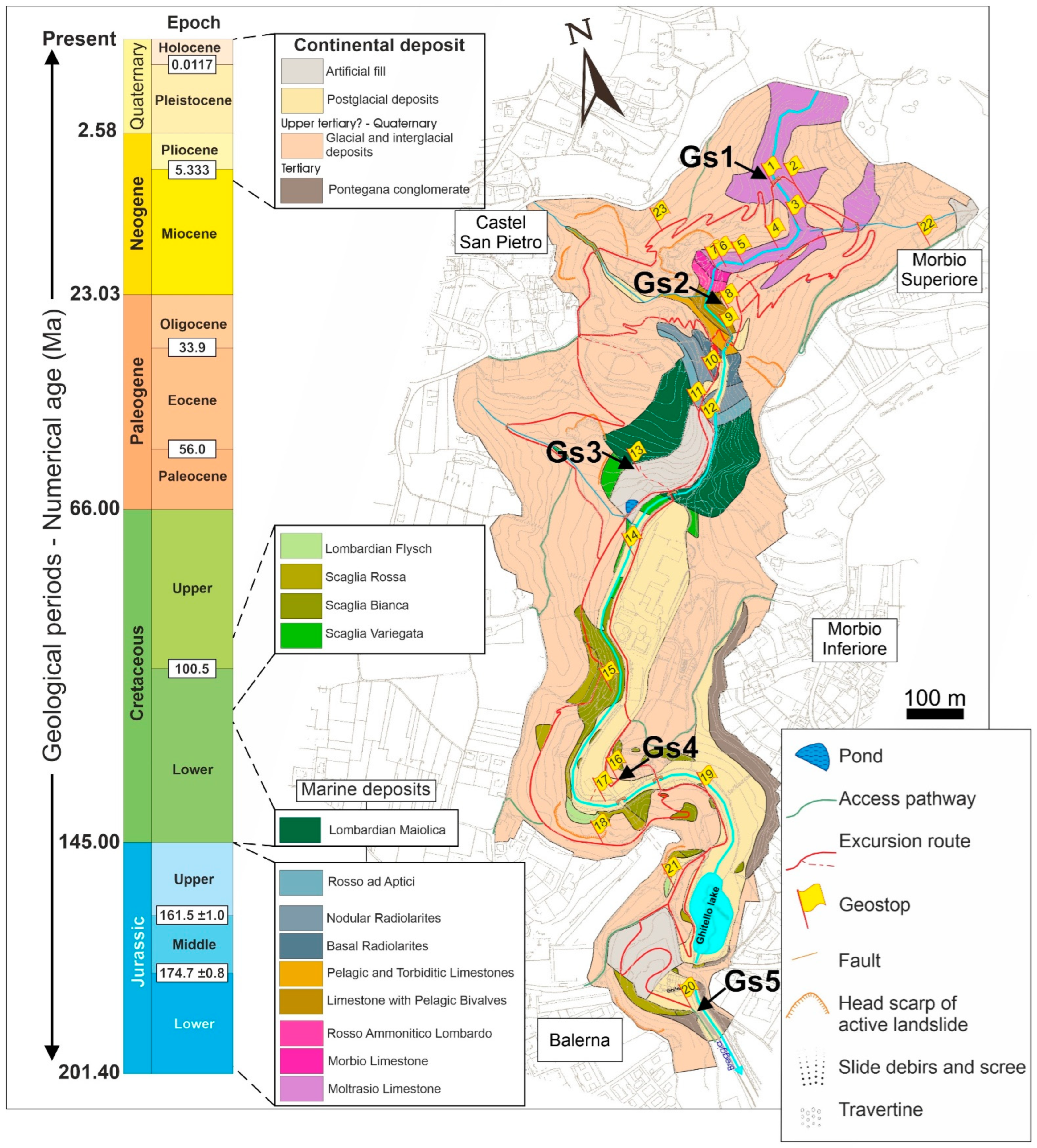
2. Overview of the Gole della Breggia Geopark

In southern Ticino (Switzerland), the Breggia River valley shows one of the most representative stratigraphic sections of the Southern Alps. These outcrops represent an exceptional record, which illustrates the sedimentary processes that took place in an overall time interval of about 100 million years, between Early Jurassic and Late Cretaceous times. However, considering the more recent rocks (from the Messinian to the Quaternary) in the park, the time interval represented here spans from the Jurassic to the present day. Due to its completeness, this cross-section is unique in the entire region (Figure 1). It shows the evolution of sedimentation and tectonics in the Southern Alps from Early Jurassic times onwards, from the early deposition of the Moltrasio Limestone, to the successive sedimentation of the Morbio Limestone, the Rosso Ammonitico Lombardo, and the Limestone with Pelagic Bivalves. All of these formations were laid down on the floor of the Tethys Ocean, which had been opening up since 180 Ma [61], separating the Eurasian Plate from the African plate. Later on, the Tethys continued spreading and deepening until 140 Ma, reaching a maximum width of about 800 km [61]. This ocean became the site of deposition of deep-sea sediments known as Radiolarites (almost entirely siliceous), the Rosso ad Aptici Formation and the Lombardian Maiolica (Late Jurassic-Early Cretaceous), the latter marking the beginning of a new geological period. All of the above sedimentary units are represented in beautiful outcrops along the park’s geotrail.
Then, about 130–120 Ma, the opening of the South Atlantic forced the African plate to rotate anticlockwise towards the European plate, generating the first compressive movements [61]. The ocean started to be consumed and marine, terrigenous deposits became widespread. In the Gole della Breggia Geopark, this paleogeographic evolution is recorded in the formations known as Scaglia and Flysch, dating back to the Cenomanian. The collision between the two plates took place slightly after 65 Ma, in Early Paleocene times [62]. At the very beginning of the Paleocene, during the early formation of the Alps, movements along a major transform fault, the Insubric Line [63], had the effect of separating the Alps from the Southern Alps. Mountain building processes reached their climax in the mesoalpine phase (45–30 Ma) and in the successive neoalpine phase (30–0 Ma). After the climax of the orogenic phases, the orogen has been subject to intensive erosion, and this is reflected in the youngest rocks of the geopark, the Pontegana Conglomerate, a terrigenous deposit of Messinan age [64,65], made of repeated accumulations of debris and mud flows in a subaerial environment. The latest event in the long geological history of this geopark took place during the most recent glacial age, in the Quaternary, with the deposition of new conglomerates that form the highest terraces in the park area, and are easily recognized for their composition, made of a mixture of dominant sedimentary rocks and a minor amount of detritus with common metamorphic pebbles and metric blocks (erratic blocks), abandoned by a tongue of the Adda glacier during its last maximum expansion [66]. The geopark is located in a periurban area of touristic interest, and this has important implications in terms of geosites management, conservation and divulgation.

3. Geosite Description

Access to the geological heritage of the whole geopark is made easier by a geotrail that features 23 geostops, all enriched with explanatory panels (Figure 1 and Figure 2).
We have chosen five stops belonging to the geotrail, which correspond to five geosites that we have selected based on the representativeness criterion, then described based on [61] and finally assessed using the most common criteria for geosite evaluation. Then, we have turned the geosites into Virtual Outcrops (VOs) and finally into Virtual Geosites (VGs); as detailed in recent papers [67,68], the creation of VOs, i.e., 3D models of outcrops, is made up of two main phases: (i) collecting images by means of Unmanned Aerial Vehicles (UAVs) (SZ DJI Technology Co., Ltd., Shenzen, China); (ii) processing the collected images through Agisoft Metashape, version 1.7.1. (http://www.agisoft.com/, accessed on 20 July 2023), a commercial Structure from Motion software (Version 1.7.1). VOs can be accessed by users virtually, in the form of VGs. In the present paper, VGs are available by clicking on QR codes embedded in the figures; moreover, they are accessible at https://geovires.unimib.it/geotrail/ (accessed on 28 August 2023).

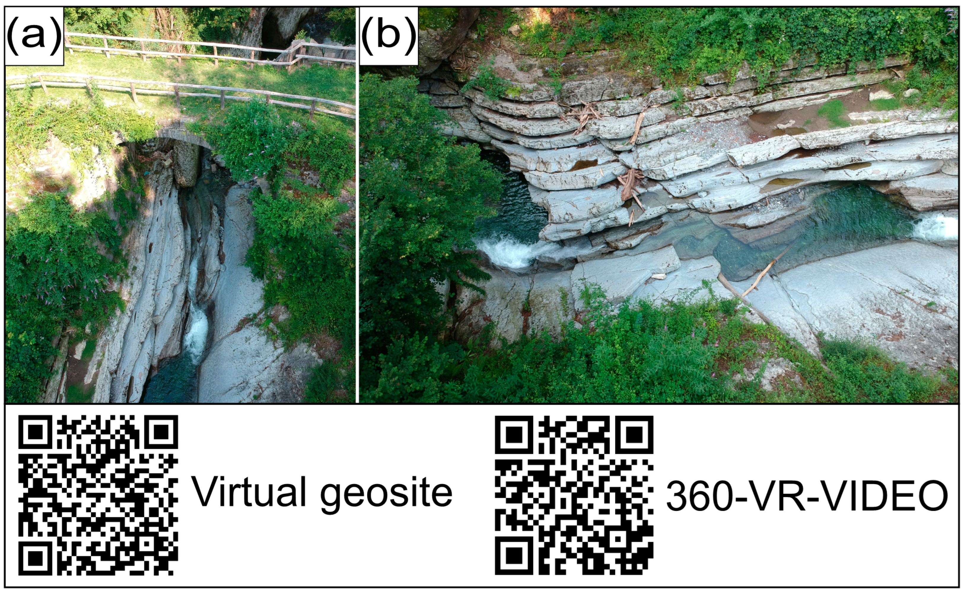
3.1. Geosite 1: The Moltrasio Limestone and a Tectonic Structure

This geosite shows the Moltrasio Limestone beds that dip towards the southwest [58]. This formation is a light gray, bedded limestone, with marly intercalations rich in muscovite and siliciclastic materials, dating back to the Early Jurassic, a time when sedimentation was taking place in a context of rifting and breakup of the Pangea supercontinent. This geosite allows us to observe a structure that is generated by tectonic forces. The Moltrasio Formation sedimentary strata are cut by a normal fault.
The development of faults represents a brittle response of the rock to tectonic stress. As is well known, along faults, energy is released in the form of earthquakes [61].
By clicking on the QR codes in Figure 3, it is possible to have access to both the Virtual Geosite and a 360° video, uploaded on YouTube.

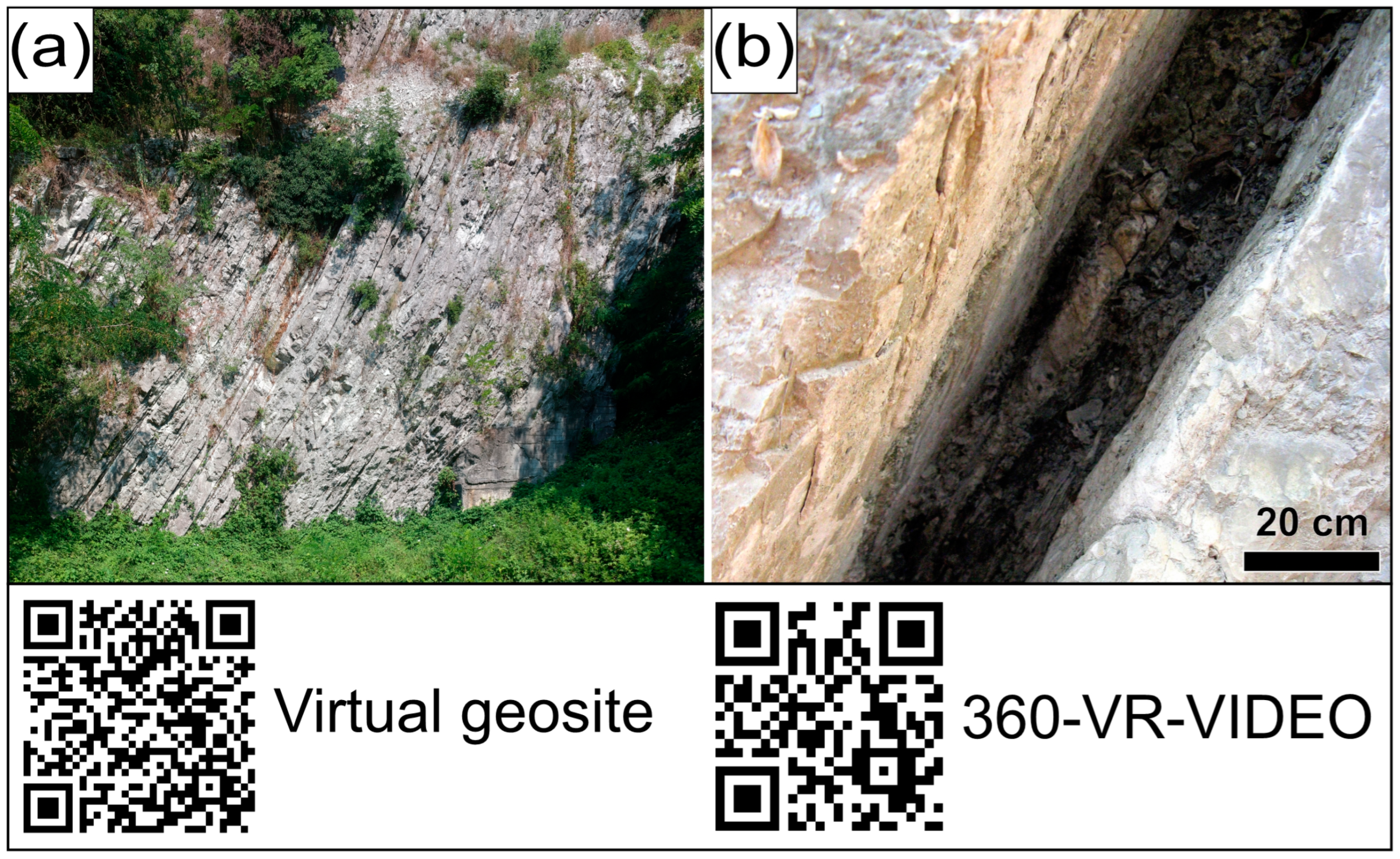
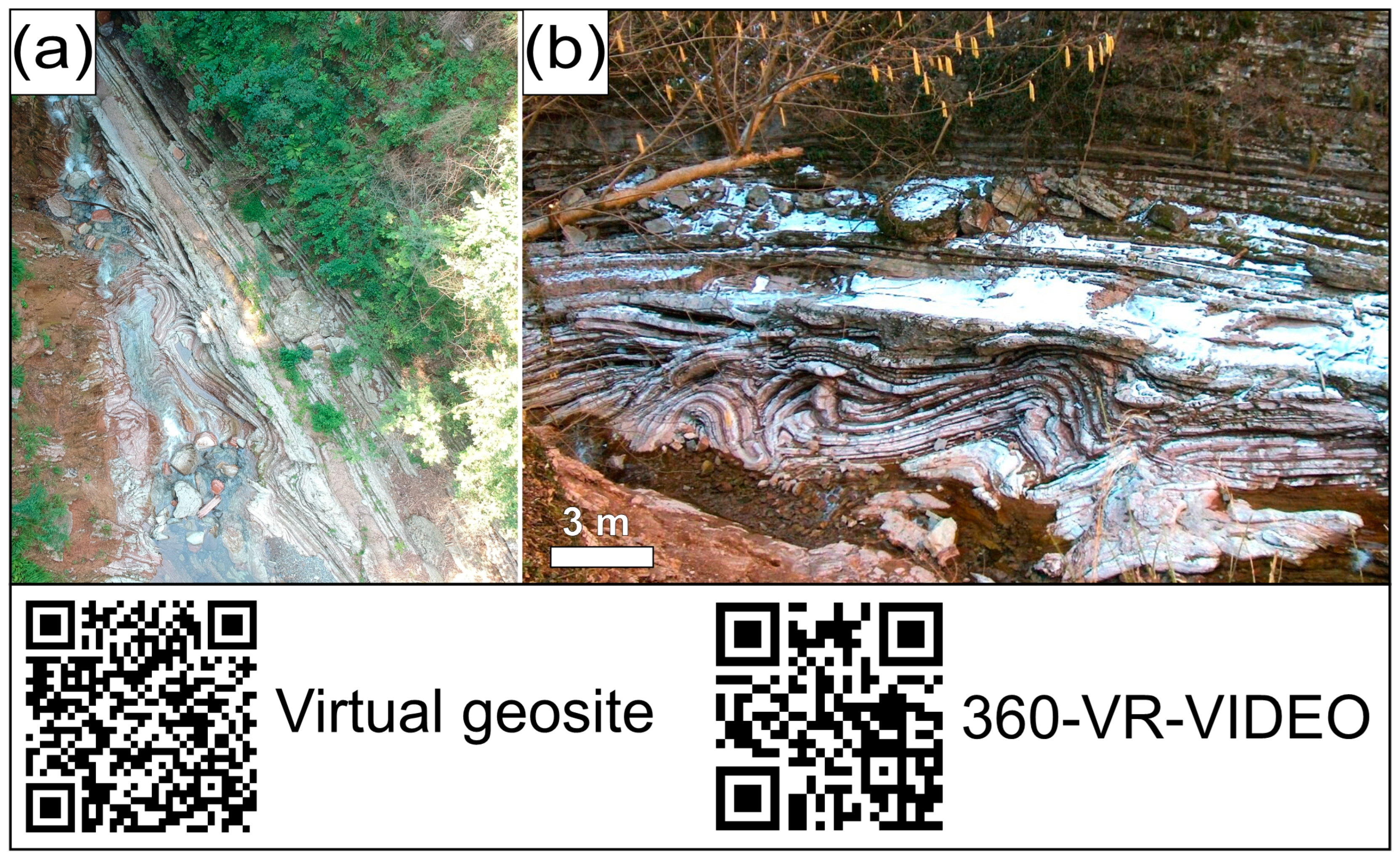
3.2. Pelagic Limestones and a Slump

The rocks that compose this geosite [61] are from the Lower to Middle Jurassic. This formation, named “Limestone with Pelagic Bivalves”, consists of well-stratified, white to pinkish limestones. This lithology is composed of more than 90% of tiny shells of bivalves (lamellibranches). Almost as if to compensate for a size of barely 2–3 mm, their number is often so high as to make up the entire rock, which therefore can be defined a fossiliferous grainstone [61]. Another particularity of Geosite 2 is surely the convoluted bedding that can be observed in Figure 4: it is the result of a synsedimentary event that took place in the depths of the ocean, while the sediment was being deposited. Along an irregular slope, a pack of strata broke loose and, dragged down by its own weight, continued to slide downwards. The strata were already well compacted but had not yet become rigid rock. They folded and buckled and in some places were fractured. This is a process known as a submarine slump (“slumping”, “gravity fold”). Following this event, the regular deposition of sediment continued, forming undisturbed parallel strata [61].

3.3. Geosite 3: The Lombardian Maiolica: From the Depths of the Alpine Tethys

The Lombardian Maiolica in the Gole della Breggia Geopark is a 130 m-thick sequence [61] composed of white, decimetric strata of fine-grained, micritic limestone, dipping 70° to the south, with typical conchoidal fracturing, containing dark chert nodules and layers [69,70,71,72]. They can contain a great abundance of aptici, calcareous plates in the form of tiny shields that might have had the function of protecting the ammonites from predators. Belemnite rostra can be present as well. At the base of the sequence (Figure 5a), rocks almost white in color reflect the purity of their composition; the percentage of calcium carbonate can reach 95%; this has enabled, over the last century, an intensive use of this resource for the concrete industry [73]. The Lombardian Maiolica (Upper Jurassic–Lower Cretaceous) was originally an ooze that “rained” slowly onto the deep seafloor of the Alpine Tethys, enveloping it in a white blanket; so slowly that 1000 years of life in the ancient ocean are compressed today into 6 mm of rock. This mud consisted of skeletons of single-cell organisms. Their cell walls, globular in form and of a gelatinous consistency, are covered with calcareous plates, elliptic or circular, which form a sort of “armour”: coccoliths. These are transformed immediately into sediment, either when the algae die, and the “armour” disintegrates or as undigested waste once the algae have been eaten [61]. Within the last 20 m of the Lombardian Maiolica, dating back to around 125 million years ago, and intercalated between the regular strata of limestone, there are layers of dark shales, 20 cm in thickness (Figure 5b).
These dark layers are slightly bituminous, due to a moderate content of organic material (up to 4% of its weight), originating from vegetal and animal decomposition. It needs to be taken into account that they reflect particularly hot, humid climatic periods (“greenhouse effect” conditions), with a resulting increase in the development of organisms, especially vegetal ones. Organic material derived from their remains then collected on the ocean floor in conditions in which there was a lack or scarcity of the oxygen that would have enabled their preservation. According to some theories, it was the decomposition of the abundant accumulation of organic material that consumed the oxygen. In addition, the existence of a stagnant seafloor is also confirmed by the stratification of these layers, which is uniformly flat and thin. This suggests that the seafloor was not only undisturbed by the effects of marine currents but was also insufficiently oxygenated to sustain the life of sediment “feeders” (e.g., worms and crustaceans) [61].

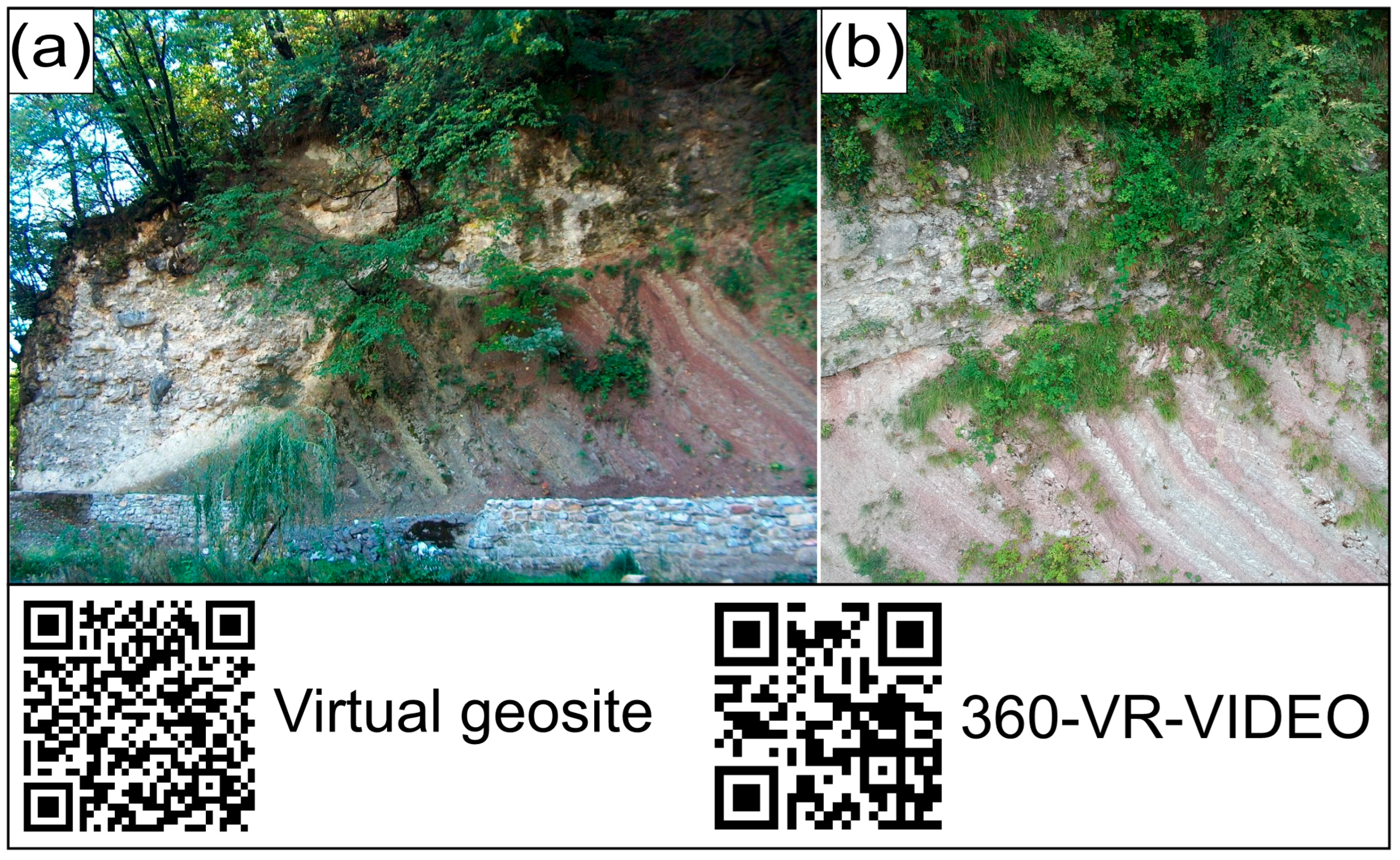
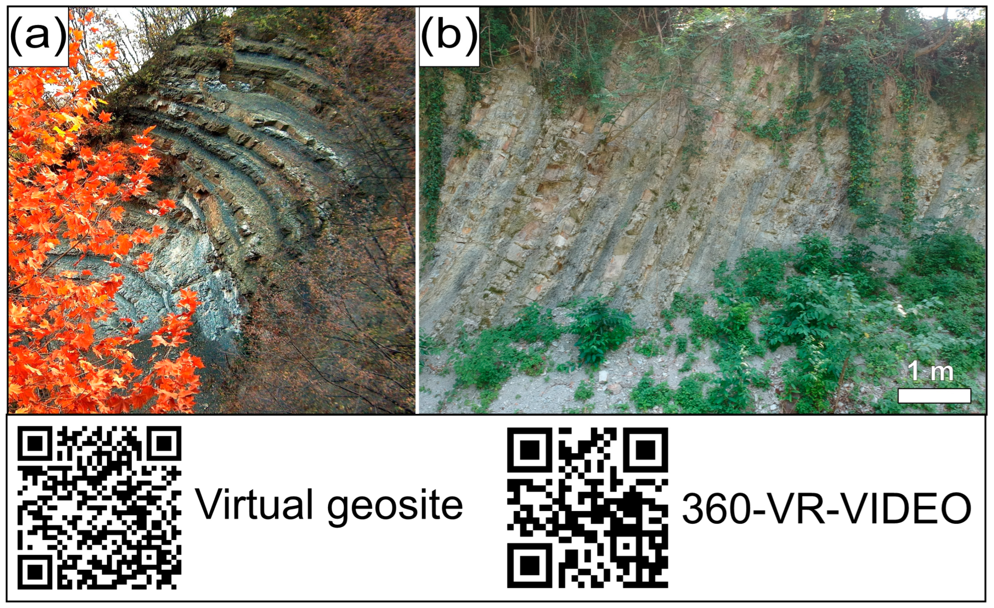
3.4. Geosite 4: A Fold Records Mountain Building Processes Leading to the Formation of the Alps

This geosite is represented by a spectacular outcrop of the Scaglia Bianca (Lower Cretaceous). This formation is made of marly limestones and white/gray marls [61]. Intercalations of clays and bituminous marls can also be noticed. The presence of the Scaglia Bianca represents the transition from rifting kinematics (which led to the fragmentation of Pangea and the formation of the Tethys) to a converging tectonic regime that eventually resulted in the formation of the Alps [71,72]. In the geopark, this transition is represented by a spectacular example of a tectonic fold (Figure 6). The fold was generated by the pressure due to the converging motion of Africa against Europe, a process which, millions of years later, ended up in their collision. This anticlinal fold is directly linked to the movements that led to the formation of the Alps.
Folding in the strata was certainly favored by the characteristics of this rock, which was originally a clayey mud. In addition, the Scaglia Bianca is also subdivided into alternated very soft marl and harder marly limestone. The former is deformed easily, while the latter behaved more strongly and buckled, giving rise to the folded layers. These folds are presently highlighted on the surface because the marly limestones are also stronger against weathering [61].

3.5. Geosite 5: A Textbook-Example of an Angular Unconformity

At the base of Geosite 5, tilted strata of the white and the red Scaglia can be observed (Scaglia Bianca and Scaglia Rossa), rocks of marine origin dating back to Early to Late Cretaceous times [61]. They were deposited in a submarine sedimentary basin, and, in this outcrop, they are covered by a conglomerate (Figure 7) composed of gravel, pebbles and boulders, mixed with sand and cemented together. This is the Pontegana Conglomerate. Despite its rather chaotic appearance, subhorizontal strata can be distinguished, marked by aligned boulders. As mentioned above, this is a continental rock of fluvial origin, dating back to the Late Miocene, precisely to the Messinian [64,65]. Its absolute age is therefore a little more than 5 million years. Consequently, between the two rocks, about 100 million years are missing. The explanation for this gap in time is that the intervening rocks were carved by successive erosion, which produced an undulated roof at the top of the white and the red Scaglia after their strata were tilted by tectonic forces leading to the formation of the Alps. In front of the viewers is a textbook-example of an angular unconformity. This geosite enables to draw an interesting conclusion. The original layers of the white and the red Scaglia must have been more or less horizontal, as is natural for muds deposited on the seafloor. Afterwards, the formation of the Alps raised and tilted them, especially during the Neoalpine phase, beginning 30 million years ago. On the contrary, the Pontegana Conglomerate flowed over the underlying formations as a debris flow [61].

4. Assessment of the Five Geosites

By applying the criteria briefly illustrated above, we can perform an assessment of the five geosites which we selected from a total of 23 geostops. It is worth highlighting that the preliminary selection which enabled us to come up with the five geosites was based on representativeness: In fact, the five geosites are all particularly exemplary in terms of how well they represent important geological features and the processes and phenomena that generated them. We are aware that the criterion of representativeness is somewhat subjective. However, we performed a thorough analysis of all 23 geostops; then, based on our in-depth knowledge of the geology of the geopark, we came up with a selection that, we believe, reduces subjectivity to a minimum. Geosite 1 (Figure 3) is representative of deep-sea calcareous sedimentation leading to the formation of well-developed sedimentary layers. Also, the normal fault in Figure 3b is exemplary in terms of the development of faults in rocks. Both the sedimentary layers of the Moltrasio limestone and the normal fault in Figure 3b are not rare occurrences, so rarity is not a value we can apply. The outcrop is very well preserved, being part of a geopark, so integrity is a value which can be applied. Another value that can be identified is by all means the educational one, as this geosite is part of a geotrail integrated by explanatory panels; moreover, geological tours with the help of expert geoguides are held at the geopark on a regular basis.
Geosite 2 (Figure 4) is highly representative of a sedimentary feature produced by gravity, in a pelagic environment. It is also a pretty rare structure, especially in terms of how the slump is clearly enclosed between regularly sedimented layers. The outcrop is very well preserved, so the integrity value can be assigned to this geosite. Here, the educational value can be applied as well, for the reasons explained for Geosite 1.
Geosite 3 (Figure 5) is highly representative of a pelagic limestone, the Maiolica, especially interesting for the dark, bituminous layers that are found intercalated between its strata. However, it is not a rare occurrence, as generally, “anoxic” layers such as these (that is, connected with reduced oxygenation) are found in rocks all over the world and were formed in a very precise period of the Earth’s history. The outcrop is perfectly preserved, so integrity is once again a value we can apply to this geosite. Moreover, we can apply the scientific value, as the Maiolica in the geopark was the subject of scientific publications, such as [66,67]. Also, here the educational value can be applied for the reasons mentioned for Geosite 1.
Geosite 4 (Figure 6) is highly representative of folding due to stresses resulting from mountain building processes. Moreover, by observing the outcrop in detail, viewers can notice the result of a process of differential erosion of a sedimentary rock made of alternating beds of soft marl and harder marly limestone. It is not a rare feature, though, as folds are widespread in the Alpine Arc. The outcrop is well preserved, so the value of integrity can be applied as well. Also, here the educational value plays a major role for the reasons mentioned for Geosite 1.
Geosite 5 (Figure 7) is representative of a structure known as angular unconformity: in this case it can be observed, with exceptional clarity, the erosional surface that puts into contact tilted, sedimentary marine rocks of Cretaceous age with continental deposits of Messinian (Late Miocene) age. The outcrop is well preserved, so its integrity is ensured. The educational value, like in the previous geosites, can be applied for the reasons explained for Geosite 1. Table 1 is aimed at summarizing the above and assigning a total score to each geosite.
As can be seen in Table 1, all sites are marked by representativeness, which was the main criterion used to select the five geosites out of 23 geostops. Only one geosite, i.e., the one showing a slump in the Limestone with Pelagic Bivalves, is characterized by rarity, whereas scientific value is applied only to one geostop, the Lombardian Maiolica.
Integrity can be applied to all geosites, since all are part of an itinerary that is preserved from anthropic interference. All are marked by the educational value as all can be visited by geotours organized on a regular basis. We do think that the results of this assessment should be added to the five explanatory panels, which should highlight that the five geostops were turned into geosites, and then into Virtual Geosites that can be viewed in VR mode. The explanatory panels should also embed our Table 1, hence enabling visitors to gain an in-depth knowledge of the values that were used to assess their quality.

5. Conclusions

The Gole della Breggia Geopark hosts a great deal of geosites, encompassing a time span of about 170 million years, from the Early Jurassic to the late Miocene. By walking along the geotrail, it is possible to observe a wide gamut of records of sedimentary and stratigraphic processes, as well as tectonic ones, the latter due to the formation of the Alpine chain. We selected five sites, which are representative of the above mentioned processes, and encompass the whole time span that characterizes the geopark, starting with the oldest rock (the Moltrasio limestone) and ending with the youngest one, the Pontegana Conglomerate. We have provided a description of the five geosites, highlighting their sedimentary, stratigraphic, tectonic and paleogeographic peculiarities. Then, we have performed a qualitative assessment of the geosites, based on several values, among which are rarity, representativeness, integrity, accessibility, safety, scientific and educational significance. In terms of quality, the most outstanding geosites are the Lombardian Maiolica, which is marked by high representativeness, integrity, and was subject to scientific publications, and the Limestone with Pelagic Bivalves, which is marked by high representativeness, integrity and rarity. Moreover, these two geosites, just like the remaining three, are characterized by a very good educational value: in fact, the geotrail is integrated by explanatory panels, and tours are organized in the geopark on a regular basis, with the involvement of expert geoguides.

Author Contributions

Conceptualization, P.O., F.P.M. and R.S.; methodology, P.O. and F.P.M.; writing—original draft preparation, P.O., F.P.M., R.S., A.S., N.C., M.P., S.A., G.V. and F.L.B. All authors have read and agreed to the published version of the manuscript.

Funding

This research received no external funding.

Data Availability Statement

No new data were created or analyzed in this study. Data sharing is not applicable to this article.

Acknowledgments

We are grateful to three reviewers, whose insightful comments and suggestions enabled us to improve the quality of our work. We also wish to thank the staff of the Geopark, for allowing us to use Unmanned Aerial Vehicles, which were key to creating the Virtual Outcrops that can be accessed by readers of the present work. This manuscript is also an outcome of the Virtual Reality lab for Earth Sciences—GeoVires (https://geovires.unimib.it/, accessed on 29 August 2023), University of Milano-Bicocca. Agisoft Metashape is acknowledged for photogrammetry processing.

Conflicts of Interest

The authors declare no conflict of interest.

References

  1. Eberhard, R. Pattern and Process: Towards a Regional Approach to National Estate Assessment of Geodiversity; Environment Aus-tralia: Canberra, Australia, 1997. [Google Scholar]
  2. Brocx, M.; Semeniuk, V. Geoheritage and geoconservation history, definition, scope and scale. J. R. Soc. West. Aust. 2007, 90, 53–87. [Google Scholar]
  3. Asrat, A.; Demissie, M.; Mogessie, A. Geoheritage conservation in Ethiopia: The case of the Simien Mountains. Quaest. Geogr. 2012, 31, 7–23. [Google Scholar] [CrossRef]
  4. Fassoulas, C.; Mouriki, D.; Dimitriou-Nikolakis, P.; Iliopoulos, G. Quantitative assessment of geotopes as an effective tool forgeoheritage management. Geoheritage 2012, 4, 177–193. [Google Scholar] [CrossRef]
  5. Wimbledon, W.A.P.; Smith-Meyer, S. Geoheritage in Europe and Its Conservation; ProGEO: Oslo, Norway, 2012. [Google Scholar]
  6. Bruno, D.E.; Crowley, B.E.; Gutak, J.M.; Moroni, A.; Nazarenko, O.V.; Oheim, K.B.; Ruban, D.A.; Tiess, G.; Zorina, S.O. Paleogeography as geological heritage: Developing geosite classification. Earth-Sci. Rev. 2014, 138, 300–312. [Google Scholar] [CrossRef]
  7. Brilha, J. Inventory and quantitative assessment of geosites and geodiversity sites: A review. Geoheritage 2016, 8, 119–134. [Google Scholar] [CrossRef]
  8. Brilha, J. Geoheritage: Inventories and evaluation. In Geoheritage: Assessment, Protection, and Management; Reynard, E., Brilha, J., Eds.; Elsevier: Amsterdam, The Netherlands, 2018; pp. 69–85. [Google Scholar]
  9. Pescatore, E.; Bentivenga, M.; Giano, S.I. Geoheritage and Geoconservation: Some Remarks and Considerations. Sustainability 2023, 15, 5823. [Google Scholar] [CrossRef]
  10. Reis, J.; Póvoas, L.; Barriga, F.J.A.S.; Lopes, C. Science education in a museum: Enhancing earth sciences literacy as a way to enhance public awareness of geological heritage. Geoheritage 2014, 6, 217–223. [Google Scholar] [CrossRef]
  11. Pasquaré Mariotto, F.; Venturini, C. Strategies and tools for improving earth science education and popularization in museums. Geoheritage 2017, 9, 187–194. [Google Scholar] [CrossRef]
  12. Venturini, C.; Pasquaré Mariotto, F. Geoheritage promotion through an interactive exhibition: A case study from the Carnic Alps, NE Italy. Geoheritage 2019, 11, 459–469. [Google Scholar] [CrossRef]
  13. Tsipra, T.; Drinia, H. Geocultural Landscape and Sustainable Development at Apano Meria in Syros Island, Central Aegean Sea, Greece: An Ecomuseological Approach for the Promotion of Geological Heritage. Heritage 2022, 5, 2160–2180. [Google Scholar] [CrossRef]
  14. Zouros, N. The European Geoparks Network—Geological heritage protection and local development. Episodes 2004, 27, 165–171. [Google Scholar] [CrossRef]
  15. De Grosbois, A.M.; Eder, W. Geoparks—A tool for education, conservation and recreation. Environ. Geol. 2008, 55, 465–466. [Google Scholar] [CrossRef]
  16. Mckeever, P.; Zouros, N.; Patzak, M. The UNESCO global network of national geoparks. In Geotourism: The Tourism of Geology and Landscape; Newsome, D., Dowling, R.K., Eds.; Goodfellow Publishers Ltd.: Oxford, UK, 2010; pp. 221–230. [Google Scholar]
  17. Bitschene, P.; Schueller, A. Geo-education and geopark implementation in the Vulkaneifel European Geopark. Geol. Soc. Am. Field Guide 2011, 22, 29–34. [Google Scholar]
  18. Bitschene, P. Edutainment with basalt and volcanoes—The Rockeskyller Kopf example in the Westeifel Volcanic Field/Vulkaneifel European Geopark, Germany. Z. Dtsch. Ges. Geowiss. 2015, 166, 187–193. [Google Scholar] [CrossRef]
  19. Pásková, M.; Zelenka, J. Sustainability Management of Unesco Global Geoparks. Sustain. Geosci. Geotourism 2018, 2, 44–64. [Google Scholar] [CrossRef]
  20. Becerra-Ramírez, R.; Gosálvez, R.U.; Escobar, E.; González, E.; Serrano-Patón, M.; Guevara, D. Characterization and Ge-otourist Resources of the Campo de Calatrava Volcanic Region (Ciudad Real, Castilla-La Mancha, Spain) to Develop a UNESCO Global Ge-opark Project. Geosciences 2020, 10, 441. [Google Scholar] [CrossRef]
  21. Perotti, L.; Bollati, I.M.; Viani, C.; Zanoletti, E.; Caironi, V.; Pelfini, M.; Giardino, M. Fieldtrips and Virtual Tours as Geotourism Resources: Examples from the Sesia Val Grande UNESCO Global Geopark (NW Italy). Resources 2020, 9, 63. [Google Scholar] [CrossRef]
  22. Widawski, K.; Ole’sniewicz, P.; Rozenkiewicz, A.; Zareba, A.; Jandová, S. Protected Areas: Geotourist Attractiveness for Weekend tourists Based on the Example of Gorcza Nski National Park in Poland. Resources 2020, 9, 35. [Google Scholar] [CrossRef]
  23. Xu, K.; Wu, W. Geoparks and Geotourism in China: A Sustainable Approach to Geoheritage Conservation and Local Development—A Review. Land 2022, 11, 1493. [Google Scholar] [CrossRef]
  24. Newsome, D.; Dowling, R.K. Geotourism: The Tourism of Geology and Landscape; Goodfellow Publishers Ltd.: Oxford, UK, 2010. [Google Scholar]
  25. Dowling, R.K. Geotourism’s global growth. Geoheritage 2011, 3, 1–13. [Google Scholar] [CrossRef]
  26. Burek, C.V. The role of LGAPs (Local Geodiversity Action Plans) andWelsh RIGS as local drivers for geoconservation within geotourism in Wales. Geoheritage 2012, 4, 45–63. [Google Scholar] [CrossRef]
  27. Ehsan, S.; Leman, M.S.; Begum, R.A. Geotourism: A tool for sustainable development of geoheritage resources. Adv. Mater. Res. 2012, 622–623, 1711–1715. [Google Scholar] [CrossRef]
  28. Hose, T.A. 3G’s for Modern Geotourism. Geoheritage 2012, 4, 7–24. [Google Scholar] [CrossRef]
  29. Hose, T.; Vasiljevi’c, D. Defining the nature and purpose of modern geotourism with particular reference to the United Kingdom and south-east Europe. Geoheritage 2012, 4, 25–43. [Google Scholar] [CrossRef]
  30. Kubalíková, L. Geomorphosite assessment for geotourism purposes. Czech J. Tour. 2013, 2, 80–104. [Google Scholar] [CrossRef]
  31. Szepesi, J.; Harangi, S.; Ésik, Z.; Novák, T.J.; Lukács, R.; Soós, I. Volcanic geoheritage and geotourism perspectives in hungary: A case of an UNESCO world heritage site, tokaj wine region historic cultural landscape, hungary. Geoheritage 2017, 9, 329–349. [Google Scholar] [CrossRef]
  32. Newsome, D.; Dowling, R. Geoheritage and Geotourism. In Geoheritage; Reynard, E., Brilha, J., Eds.; Elsevier: Amsterdam, The Netherlands, 2018; pp. 305–321. [Google Scholar]
  33. Kubalíková, L. Assessing Geotourism Resources on a Local Level: A Case Study from Southern Moravia (Czech Republic). Resources 2019, 8, 150. [Google Scholar] [CrossRef]
  34. Beltrán-Yanes, E.; Dóniz-Páez, J.; Esquivel-Sigut, I. Chinyero Volcanic Landscape Trail (Canary Islands, Spain): A Geotourism Proposal to Identify Natural and Cultural Heritage in Volcanic Areas. Geosciences 2020, 10, 453. [Google Scholar] [CrossRef]
  35. Zafeiropoulos, G.; Drinia, H.; Antonarakou, A.; Zouros, N. From geoheritage to geoeducation, geoethics and geotourism: A critical evaluation of the greek region. Geosciences 2021, 11, 381. [Google Scholar] [CrossRef]
  36. Wimbledon, W.A.P. GEOSITES-a new conservation initiative. Episodes 1996, 19, 87–88. [Google Scholar] [CrossRef]
  37. Wimbledon, W.A.P.; Andersen, S.; Cleal, C.J.; Cowie, J.W.; Erikstad, L.; Gonggrijp, G.P.; Johansson, C.E.; Karis, L.O.; Suominen, V. Geological world heritage. GEOSITES: A global comparative site inventory to enable prioritisation for conservation. Mem. Descr. Della Carta Geol. D’Italia 1996, 56, 45–60. [Google Scholar]
  38. Fuertes-Gutiérrez, I.; Fernández-Martínez, E. Mapping geosites for geoheritage management: A methodological proposal for the regional park of picos de Europa (León, Spain). Environ. Manag. 2012, 50, 789–806. [Google Scholar] [CrossRef] [PubMed]
  39. Palacio Prieto, J.L.; de Castro Martínez, G.F.; González, E.M.R. Geotrails in the mixteca alta UNESCO Global Geopark, Oaxaca, Mexico. Cuad. Geogr. 2019, 58, 111–125. [Google Scholar]
  40. Herrera-Franco, G.; Erazo, K.; Mora-Frank, C.; Carrión-Mero, P.; Berrezueta, E. Evaluation of a Paleontological Museum as Geosite and Base for Geotourism. A Case Study. Heritage 2021, 4, 1208–1227. [Google Scholar] [CrossRef]
  41. Joyce, B. Geomorphosites and volcanism. In Geomorphosites; Reynard, E., Coratza, P., Regolini-Bissig, G., Eds.; Verlag Dr. Friedrich Pfeil: München, Germany, 2009; pp. 175–188. [Google Scholar]
  42. Németh, K.; Casadevall, T.; Moufti, M.R.; Marti, J. Volcanic Geoheritage. Geoheritage 2017, 9, 251–254. [Google Scholar] [CrossRef]
  43. Rapprich, V.; Lisec, M.; Fiferna, P.; Závada, P. Application of Modern Technologies in Popularization of the Czech Volcanic Geoheritage. Geoheritage 2017, 9, 413–420. [Google Scholar] [CrossRef]
  44. Pasquaré Mariotto, F.; Bonali, F.L.; Tibaldi, A.; Rust, D.; Oppizzi, P.; Cavallo, A. Holocene displacement field at an emerged oceanic trans-form-ridge junction: The Husavik-Flatey Fault—Gudfinnugja Fault system, North Iceland. J. Struct. Geol. 2015, 75, 118–134. [Google Scholar] [CrossRef]
  45. Frassi, C.; Amorfini, A.; Bartelletti, A.; Ottria, G. Popularizing Structural Geology: Exemplary Structural Geosites from the Apuan Alps UNESCO Global Geopark (Northern Apennines, Italy). Land 2022, 11, 1282. [Google Scholar] [CrossRef]
  46. Franceschelli, M.; Columbu, S.; Elter, F.M.; Cruciani, G. Giant Garnet Crystals in Wollastonite–Grossularite–Diopside-Bearing Marbles from Tamarispa (NE Sardinia, Italy): Geosite Potential, Conservation, and Evaluation as Part of a Regional Environmental Resource. Geoheritage 2021, 13, 96. [Google Scholar] [CrossRef]
  47. Tibaldi, A.; Bonali, F.L.; Pasquaré, F.; Rust, D.; Cavallo, A.; D’Urso, A. Structure of regional dykes and local cone sheets in theMidhyr-na-Lysuskard area, Snaefellsnes Peninsula (NW Iceland). Bull. Volcanol. 2013, 75, 764. [Google Scholar] [CrossRef]
  48. Mikhailenko, A.V.; Ruban, D.A.; Yashalova, N.N.; Rebezov, M.B. The Unique Granite Gorge in Mountainous Adygeya, Russia: Evidence of Big and Complex Geosite Disproportions. Geosciences 2019, 9, 372. [Google Scholar] [CrossRef]
  49. Gioncada, A.; Pitzalis, E.; Cioni, R.; Fulignati, P.; Lezzerini, M.; Mundula, F.; Funedda, A. The Volcanic and Mining Geoheritage of San Pietro Island (Sulcis, Sardinia, Italy): The Potential for Geosite Valorization. Geoheritage 2019, 11, 1567–1581. [Google Scholar] [CrossRef]
  50. Panizza, M. The Geomorphodiversity of the Dolomites (Italy): A key of geoheritage assessment. Geoheritage 2009, 1, 33–42. [Google Scholar] [CrossRef]
  51. Pescatore, E.; Bentivenga, M.; Giano, S.I.; Siervo, V. Geomorphosites: Versatile Tools in Geoheritage Cultural Dissemina-tion. Geoheritage 2019, 11, 1583–1601. [Google Scholar] [CrossRef]
  52. de Lima, F.F.; Brilha, J.B.; Salamuni, E. Inventorying geological heritage in large territories: A methodological proposal applied to Brazil. Geoheritage 2010, 2, 91–99. [Google Scholar] [CrossRef]
  53. Grandgirard, V. L’évaluation des géotopes. Geol. Insubr. 1999, 4, 59–66. [Google Scholar]
  54. Reynard, E.; Fontana, G.; Kozlik, L.; Scapozza, C. A method for assessing “scientific” and “additional values” of geomorpho-sites. Geogr. Helv. 2007, 62, 148–158. [Google Scholar] [CrossRef]
  55. Coratza, P.; Giusti, C. Methodological proposal for the assessment of the scientific quality of of geomorphosites. Geoheritage 2005, 18, 307–313. [Google Scholar]
  56. Coratza, P.; Panizza, M. Geomorphology and Cultural Heritage. In Memorie Descrittive Della Carta Geologica d’Italia; ISPRA: Rome, Italy, 2009; p. 87. [Google Scholar]
  57. Zafeiropoulos, G.; Drinia, H. Comparative Analysis of Two Assessment Methods for the Geoeducational Values of Geosites: A Case Study from the Volcanic Island of Nisyros, SE Aegean Sea, Greece. Geosciences 2022, 12, 82. [Google Scholar] [CrossRef]
  58. Bruschi, V.M.; Cendrero, A.; Albertos, J.A.C. A Statistical Approach to the Validation and Optimisation of Geoheritage Assessment Procedures. Geoheritage 2011, 3, 131–149. [Google Scholar] [CrossRef]
  59. Reynard, E.; Perret, A.; Bussard, J.; Grangier, L.; Martin, S. Integrated approach for the inventory and management of geomor phological heritage at the regional scale. Geoheritage 2015, 8, 43–60. [Google Scholar] [CrossRef]
  60. Suzuki, D.A.; Takagi, H. Evaluation of geosite for sustainable planning and management in geotourism. Geoheritage 2017, 10, 123–135. [Google Scholar] [CrossRef]
  61. Stockar, R. Geological Guide to the Breggia Gorge Park; The Breggia Gorge Park: Morbio Inferiore, Switzerland, 2003. [Google Scholar]
  62. Malusà, M.G.; Guillot, S.; Zhao, L.; Paul, A.; Solarino, S.; Dumont, T.; Schwartz, S.; Aubert, C.; Baccheschi, P.; Eva, E.; et al. The Deep Structure of the Alps Based on the CIFALPS Seismic Experiment: A Synthesis. Geochem. Geophys. Geosystems 2021, 22, e2020GC00946. [Google Scholar] [CrossRef]
  63. Schmid, S.M. On the Insubric line and the Southern Steep Belt of the Penninic nappes in the Ticino area (including 2 excursion guides). Swiss Bull. Appl. Geol. 2017, 22, 69–89. [Google Scholar]
  64. Rutishauser, V. Das Südtessin im Neogen: Zwischen Schuttstrom und Schelfmeer—Eine Facies—und Ablagerungsraumanalyse. Mitt. Geol. Inst. Eidg. Tech. Hochsch. Univ. Zürich 1986, 251, 150. [Google Scholar]
  65. Zanchi, A.; Rigamonti, I.; Felber, M.; Bini, A. Evidenze di tettonica recente e di glaciotettonica nel Mendrisiotto (Ticino me-ridionale, Svizzera). Il Quat.—Ital. J. Quat. Sci. 1995, 8, 279–290. [Google Scholar]
  66. Vignola, P.; Andò, S.; Vezzoli, G.; Oppizzi, P. I minerali pesanti nelle sabbie della Breggia. In Il Parco Della Breggia; Contributi Alla Sua Conoscenza; Oppizzi, P., Spinedi, F., Eds.; Soc. Ticinese Sc. Nat. e Museo cantonale di Storia Naturale: Lugano, Switzerland, 2007; pp. 79–90. [Google Scholar]
  67. Pasquaré Mariotto, F.; Bonali, F.L. Virtual Geosites as Innovative Tools for Geoheritage Popularization: A Case Study from Eastern Iceland. Geosciences 2021, 11, 149. [Google Scholar] [CrossRef]
  68. Pasquaré Mariotto, F.; Antoniou, V.; Drymoni, K.; Bonali, F.L.; Nomikou, P.; Fallati, L.; Karatzaferis, O.; Vlasopoulos, O. Virtual Geosite Communication through a WebGIS Platform: A Case Study from Santorini Island (Greece). Appl. Sci. 2021, 11, 5466. [Google Scholar] [CrossRef]
  69. Rieber, H. Eine Ammonitefauns aus der oberen Maiolic der Breggia-Schlucht (Tessin/Schweiz). Eclogae Geol. Helv. 1977, 70, 7777–7787. [Google Scholar]
  70. Renz, O.; Habicht, K. A correlation of the Tethyan Maiolica formation of the Breggia Section (southern Switzerland) with Early Cretaceous coccolith oozes of site 534A, DSDP Leg 76 in the western Atlantic. Eclogae Geol. Helv. 1985, 78, 383–431. [Google Scholar]
  71. Bernoulli, D.; Ambrosi, C.; Scapozza, C.; Castelletti, C.; Wiedenmayer, F. Foglio 1373 Mendrisio (Parte Est) Con Parte Ovest Del Foglio Como. Atlante Geologico Della Svizzera 1:25,000, Carta 152; Ufficio Federale di Topografia: Wabern, Germany, 2017. [Google Scholar]
  72. Bernoulli, D.; Ambrosi, C.; Scapozza, C.; Stockar, R.; Schenker, F.L.; Gaggero, L.; Antognini, M.; Bronzini, S. Foglio 1373 Mendrisio (Parte Est) con Parte Ovest del Foglio Como. Atlante Geologico della Svizzera 1: 25 000, Note Esplicative 152; Ufficio Federale di Topografia: Wabern, Germany, 2018. [Google Scholar]
  73. Oppizzi, P. Il Cementificio della Saceba. In Il Parco Della Breggia. Contributi Alla Sua Conoscenza; Oppizzi, P., Spinedi, F., Eds.; Soc. Ticinese Sc. Nat. e Museo cantonale di Storia Naturale: Lugano, Switzerland, 2007; pp. 175–180. [Google Scholar]
Figure 1. The Parco della Breggia geotrail. Modified after [61]. Geological time scale is from the International Commission on Stratigraphy (https://stratigraphy.org/chart, accessed on 22 August 2023). Gs 1–5: Geosites 1 to 5.
Resources 12 00122 g001
Figure 2. The first of 23 explanatory panels that enable visitors to gain a comprehensive picture of the geological contents of the geopark. There is also a geoguide, both in Italian and English, which provides visitors with an overall view of the geological history recorded in the geopark [61].
Resources 12 00122 g002
Figure 3. (a) UAV-captured image of the Moltrasio limestone; (b) UAV-collected photograph of the fault dissecting the layers of the Moltrasio. The two QR codes enable viewers to access the Virtual Geosite and a 360° video.
Resources 12 00122 g003
Figure 4. (a) UAV-captured image of the slump in the pelagic limestones. (b) Photograph taken at closer distance, where the effects of the process that produced the slump can be observed. In the lower hand side of the image, it is worth noticing the folding and partial fracturing of the strata involved, originally in a plastic state. Above the folds, the strata resume their regularity, indicating a return to normality on the seafloor. The two QR codes enable viewers to access the Virtual Geosite and a 360° video.
Resources 12 00122 g004
Figure 5. (a) UAV-captured picture of the steeply-dipping strata of the Lombardian Maiolica; (b) detail of a dark, bituminous layer intercalated between the white strata of the Lombardian Maiolica. The two QR codes enable viewers to access the Virtual Geosite and a 360° video.
Resources 12 00122 g005
Figure 6. (a) UAV-captured view of the layers of Scaglia Bianca deformed by the fold; (b) detail of steeply-dipping strata of the Scaglia Bianca. The two QR codes enable viewers to access the Virtual Geosite and a 360° video.
Resources 12 00122 g006
Figure 7. (a) UAV-captured picture of the angular unconformity between the two formations, separated by 100 million years of geological history; (b) detail of the steeply-dipping layers of the white and the red Scaglia, abruptly truncated by erosion and covered by the clastic sediments of the Pontegana conglomerate. The two QR codes enable viewers to access the Virtual Geosite and a 360° video.
Resources 12 00122 g007
Table 1. Table graphically summarizing the results of the assessment conducted on the five geosites.
Geosite 1Geosite 2Geosite 3Geosite 4Geosite 5
Representativeness
Rarity----
Integrity
Scientific value----
Educational value
SCORE34433
Disclaimer/Publisher’s Note: The statements, opinions and data contained in all publications are solely those of the individual author(s) and contributor(s) and not of MDPI and/or the editor(s). MDPI and/or the editor(s) disclaim responsibility for any injury to people or property resulting from any ideas, methods, instructions or products referred to in the content.

