Abstract
In recent decades, geotourism has been presented as an alternative for the sustainable socioeconomic development of the community. In addition, it shows significant growth. Portovelo canton, located in the south of Ecuador, is characterised by a significant geological importance complemented by the mining culture and history interest, turning into the first mining centre. Mining is the main economic activity in the area. However, the development of illegal mining without technical considerations affects the canton and its surroundings. Faced with this problem, the need arises for alternatives to improve the inhabitants’ quality of life and protect their geological heritage. This work aims to propose a geotouristic route (GR) in the course of the Amarillo River through the characterisation and quantitative assessment of 10 interest sites (four geosites and six touristic sites), which enhance the geotourism development of the canton, including geoconservation strategies. The methodological process includes (i) characterisation of sites and GR proposal, (ii) sites and GR assessment using the Geotouristic Route Assessment Matrix method (GtRAM, acronym in Spanish) and Brilha method for geosites, and (iii) proposal of geotourism development and geoconservation strategies in a sustainability framework through the analysis of strengths, opportunities, weaknesses, and threats (SWOT). The results obtained from the proposed GR reflect that 60% of the proposed sites have a tourist interest classified as high, of which the Museo Mineralógico Magner Turner was the best-rated geoheritage element. Similarly, the high scientific, educational, and tourist values of the proposed geoheritage sites are highlighted. Strategies have been established to enhance the GR value: (i) Promoting geotourism through different activities and (ii) proposals for geoconservation and conditioning of geoheritage sites and tourist interest sites considering the geological and environmental impact. The methodology used in the study made it possible to establish geo-guidelines focused on local development, which are coupled with the knowledge of two main groups: Geo-experts and the community.
1. Introduction
Natural diversity can be understood as integrating biotic (biodiversity) and abiotic (geodiversity) components of nature [1]. Although geodiversity is relatively new, it was consolidated from the 1990s, developing a high scientific production until today [2,3]. According to Gray [4], geodiversity can be defined as “the natural range (diversity) of geological (rocks, minerals, fossils), geomorphological (landforms, processes), and soil features”. Geodiversity can also be defined as the geological variety around elements, such as geological structures (faults, stratifications), minerals, rocks, fossils or soils [5,6].
When the elements that constitute geodiversity present a scientific interest, they are recognized as geological heritage or geoheritage [7,8], which includes geosites (in situ) and geoheritage elements (ex situ) [1]. The relevance of geoheritage refers to the need for geoconservation through restructuring, conservation, and rescue systems for unique geological features [9,10]. According to Jakubowski [11], within the geological heritage, it is important to distinguish two types of categories: (i) Immovable geological heritage (IGH) and (ii) movable geological heritage (MGH). The IGH includes geodiversity elements with a scientific value that cannot be removed from the surrounding environment, for which protection must be in situ, while the MGH includes geodiversity elements with a scientific value that must be protected ex situ within a museum. The inclusion of the MGH in a museum collection often represents the only opportunity to preserve these invaluable inanimate natural monuments [11,12].
Geosites are sites of geological interest with high scientific, educational, and tourist values, representing the geological heritage and promoting conservation [13]. Geosites also include forms of particular importance due to their geological rarity or representativeness, didactic value, landscape importance, and historical–cultural interest [14,15,16].
In general, these sites with high geological interest are usually assessed through qualitative and quantitative methods to determine management, conservation, and prevention strategies against natural and anthropic threats [17]. There are several methods for the sites assessment from the point of view of their geological interest [1,18,19,20,21,22,23,24,25,26]. These methods, in general, are based on determining the scientific, educational, cultural, landscape/aesthetic value, ecological value, potential use value, recreational value, degradation risk, economic value, and tourist value of the studied site. In some studies (e.g., [16]), geoheritage elements assessment with geosite assessment methods has allowed for the proposition of conservation strategies.
An alternative to promote the geoconservation of a given area is geotourism. To date, geotourism has been defined by several authors [27,28,29,30,31,32,33,34,35,36]. According to Hose and Vasiljević [29], a new definition for modern geotourism could be “The provision of interpretative and service facilities for geosites and geomorphosites and their encompassing topography, together with their associated in situ and ex situ artefacts, to constituency-build for their conservation by generating appreciation, learning and research by and for current and future generations”. Currently, the most internationally accepted definition is from Newsome and Dowling [37]: “Geotourism is a form of natural area tourism that specifically focuses on geology and landscape. It promotes tourism to geosites and the conservation of geodiversity, and an understanding of earth sciences through appreciation and learning. This is achieved through independent visits to geological features, use of geotrails and viewpoints, guided tours, geoactivities, and patronage of geosite visitor centres”. In general, geotourism can be considered a tool that promotes natural and cultural heritage, and fosters local and regional economic development [38,39].
Through geotourism, there are several actions focused on economic sustainability and geoconservation, such as the creation of geoparks [40,41], georoutes [42], and the assessment and heritage conservation (cultural, geological, and mining [34,43,44] of the geosites used as a tool for understanding geological processes (geoeducation) [27,45,46]. Geological routes (georoutes) are itineraries based on the knowledge, interpretation, and preservation of geological heritage through the connection of different geosites in a way that is sequential and ordered [47,48,49,50]. There are several examples of georoutes in different countries, such as Italy (e.g., [51]), Brazil (e.g., [52]), Chile (e.g., [49]), and Spain (e.g., [42]). Similarly, there are the so-called “geotouristic routes” that, unlike georoutes, contain, in addition to sites of geological interest, other sites of interest: Natural, archaeological, architectural, and agricultural [53,54]. Some examples of this type of routes are: The “Ruta de las Piritas” in Spain (e.g., [55]), the “Royal Entrance” in Brazil (e.g., [56]), “Ruta de la piedra” in Portugal (e.g., [44]), and “Gold Route” in Ecuador (e.g., [46]).
In Ecuador, since the declaration of the Imbabura Geopark as a UNESCO World Geopark in 2019, the definition of geological heritage, its need for protection, and its use as an alternative for sustainable development have generated attention in recent years [57]. According to Berrezueta et al. [58], there are nine geopark projects and initiatives in the country to date (e.g., Napo Sumaco Geopark Project, Santa Elena Geopark Project, Tungurahua Volcano Geopark Project, and Ruta del Oro Geopark Project). The Ruta del Oro Geopark Project in the study area is made up of five municipalities: Atahualpa, Chilla, Piñas, Portovelo, and Zaruma [58]. The main objective of this project is to generate sustainable development alternatives through geotourism [46].
Portovelo canton is located in the southwest of Ecuador, in the province of El Oro. The study locality is crossed by the Amarillo River and is characterised by an irregular topography since it is part of the mountains present in the coastal region. Its attractive slopes are due to its streets’ layout and the view of the striking landscapes with the naked eye [45,59]. Its geological heritage is concentrated in the cities and towns surrounding Portovelo since they are old and have a diversity of traditions and customs that emanate a typical singularity of the sector, which allows for the establishment of a potential tourism sector [46,60]. This hydrological resource is one of the significant riches of the urban area. However, the inhabitants’ contact with the water has not been adequate, and the planning processes have not known how to propose strategies that help preserve its landscape and geological attractions around them [61,62]. Therefore, based on the need to strengthen the management and promotion of the geological wealth of the canton, the following question arises: How to establish strategic guidelines for the development of geotourism in Portovelo, considering interesting geological sites in the course of the Amarillo River?
This article aims to propose a geotouristic route (GR) in the course of the Amarillo River through the characterisation and quantitative assessment of 10 interest sites (four geosites and six touristic sites), which enhance the geotourism development of the canton. The assessment process will be carried out through two different methodologies: (i) Brilha method [1] applied to geosites and (ii) Geotouristic Route Assessment Matrix method (GtRAM) [47] applied to geotouristic routes. Finally, the study is complemented by analysing the strengths, weaknesses, opportunities, and threats (SWOT) to define strategies for conservation and conditioning of sites as a basis for local development.
2. Geographical and Geological Setting
Portovelo is a city in the southeast of the El Oro province in Ecuador (Figure 1a,b) and one of the main cities that make up the Zaruma-Portovelo mining district. This city is one of the 14 cantons that make up the province of El Oro, with an approximate area of 35 km2. The area is located on the western slope of the Andes Mountains, in the upper basin of the Puyango-Tumbes River [63,64]. Landscapes characterise the mountainous relief with steep slopes from 20 to 45° [65]. The topography of the place presents elevations that vary between 600 and 1600 m above sea level [66], with fluvial incisions with important water flows [67,68]. It is crossed by the Amarillo River and Calera River (Figure 1c), with a warm climate characterised by temperatures between 18 and 30 °C [69]. The water flow of the main rivers is conditioned by an average annual rainfall of 1300 mm, which occurs in two seasons (January to May and October to November) [65,70].
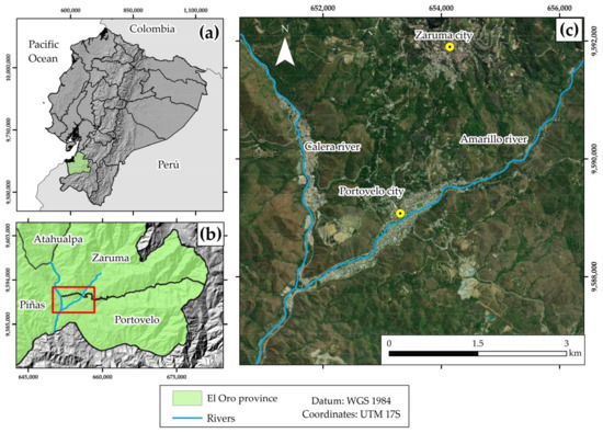
Figure 1.
Location of the study area: (a) and (b) general context; (c) local context.
Regionally, Portovelo and its surroundings are in the extension of the southwestern segment of the Miocene metallogenic belt (Azuay-El Oro district mineral deposits) in Ecuador [71], specifically in the Zaruma-Portovelo mining district [72,73]. This district contains Tertiary granitoids [74], such as the Cangrejos–Zaruma intrusive complex [71], where there is significant structural control of the dextral Palestine and Piñas faults with a NW–SE trend [75,76]. This structural dynamic has favoured the formation of dilation spaces for the location of vein assemblages, where gold mineralisation occurs [59,77,78], and associated minerals, such as pyrite, chalcopyrite, quartz, sphalerite calcite, galena, bornite, hematite, tetrahedrite, and molybdenite [59,79,80]. The area’s geology consists of metamorphic, igneous, and sedimentary rocks ranging from the Proterozoic–Paleozoic to the Quaternary age [77].
From a socioeconomic point of view, Portovelo is one of the oldest mining (gold extraction) cities in Ecuador [69,81]. With a population of 12,200 inhabitants, according to the last census carried out in 2010 [82], it is estimated that more than 70% of its population are directly dedicated to artisanal mining [83], while the other 30% of the inhabitants are engaged in agricultural, livestock, and tourist activities [64]. Within the Zaruma-Portovelo mining district, more than 20,000 people depend directly or indirectly on extractive activity [69], of these, 8540 correspond to inhabitants of the Portovelo canton. Mining activity uses mercury intensively in gold recovery processes, generating environmental problems [69]. According to Turner-Carrión et al. [64], in the last decade, the Portovelo city in particular, and the Zaruma-Portovelo mining district in general, have promoted tourism through its cultural, gastronomic, geological, archaeological, and mining history.
3. Materials and Methods
The work carried out comprises three phases: (i) Geosites characterisation and geotouristic route (GR) proposal, (ii) geosites and GR assessment using the Brilha method [1] and Geotouristic Route Assessment Matrix method (GtRAM) [47], and (iii) proposal of geotourism development and geoconservation strategies in a sustainability framework through the analysis of strengths, opportunities, weaknesses, and threats (SWOT) [84] (Figure 2).
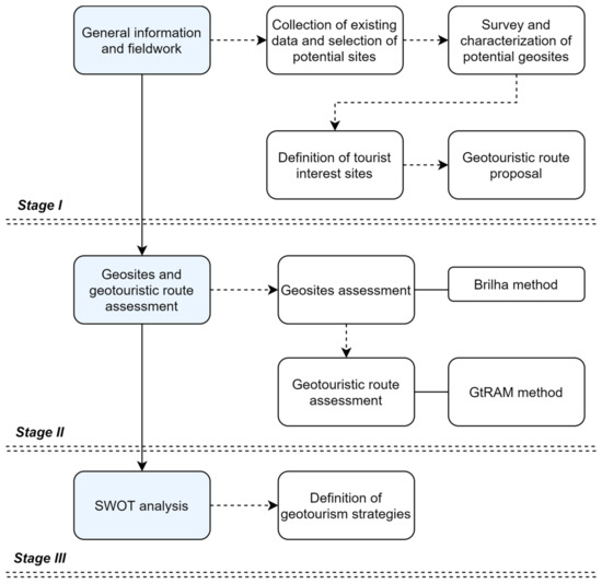
Figure 2.
The general methodology of the study.
3.1. General Information and Fieldwork
In this first stage, the existing information on the web (e.g., thematic cartography and preliminary studies of geosites assessment developed in the area, together with existing geological data) was reviewed and processed to define a list of potential geosites. Specifically, this study addressed the selection of geological interest sites based on previous work carried out by Carrión Mero et al. [46]. The criteria for selecting the potential geosites were the proximity to the Amarillo River (Portovelo), accessibility, the proximity between geosites, and geosites with highest scores in previous assessment.
Subsequently, the survey and characterisation of the main general geological features of the selected geosites were carried out. This stage also includes selecting and characterising sites with tourist interest (e.g., biodiversity, cultural, historical). Finally, the list of potential geosites and tourist interest sites is used to define a geotourism route (GR) that contributes to strengthening the socioeconomic activities of the city.
3.2. Geosites and Geotouristic Route Assessment
The quantitative assessment processes of sites with representative geological interest are essential to executing geoconservation plans [17] or geotourism development [37]. According to Valente et al. [85], the educational and tourist aspect that the Brilha method evaluates allows for the determination of sites with appropriate geological characteristics to spread geological knowledge at different levels of education through their inclusion in geoitineraries. Considering that the Brilha method includes five additional parameters in the evaluation of potential tourism use (vulnerability, use limitations, safety, scenario, and uniqueness), concerning the parameters of the tourism profile that are assessed with the IELIG method, in this study, the potential geosites were evaluated using the Brilha method [1]. This new assessment is carried out to complement the previous assessment, specifically in the tourist value of the selected geosites, and better support their consideration within the GR. On the other hand, applying several methodologies allowed one to obtain a better result of the potential of the geosites and reduce the subjectivity of the evaluation methods [86].
In general, the quantitative method used allows for the assessment of geological interest sites through four main indicators: (i) Scientific value (SV), (ii) potential educational use (UEP), (iii) potential tourist use (PTU), and (iv) degradation risk (DR) [1]. Each indicator includes different sub-indicators, with values from 1 (minimum score) to 4 (maximum score), which have different weights according to what the method proposes (Table 1). When evaluating the SV, PEU, and PTU indicators, a high value has a positive connotation for the geosite. However, when assessing the DR indicators, high values represent negative connotations (risk) for the geosite.

Table 1.
Criteria and indicators used for the quantitative assessment of geosites [1]. SV (100 to 400), PEU (100 to 400), PTU (100 to 400), and DR (100 to 400). The DR obtained can be classified as: Low (<200), medium (201–300) or high (301–400).
Furthermore, the Geotouristic Routes Assessment Matrix (GtRAM) method [47] is applied to all of the sites (geosites and tourist interest sites) that constitute the GR. Specifically, to obtain a global assessment of this and each site that constitutes it. The objective of this method is to assess the tourism potential of each site on the route based on six parameters: Accessibility, preparation and logistics, registration with the Ministry of Tourism, regarding heritage, contribution to scientific knowledge and ecotourism (Table 2). Each parameter can be scored from 1 (lowest value) to 5 (highest value). If the site does not meet the assessed parameter, the assigned score is 0. The final value of each site is obtained from the average of the values assigned to each evaluated parameter. Finally, the value of the GR is obtained from the average global value of each site. The results are classified with values that advance from low to very high, where (1–1.9) is considered “Low”, (2–2.9) “Medium”, (3–3.9) “High”, and (4–5) “Very high” [47]. Sites with scores below 1 will not be considered with tourism potential, discarding their inclusion in the route.
Table 2.
Parameters used for the geotouristic routes assessment through the GtRAM method [47]. Interpretation (value range): Minimum total average (1) and maximum total average (5). The tourist interest obtained can be classified as: Low (1–1.9), Medium (2–2.9), High (3–3.9), and Very high (4–5).
The assessment methods used were carried out by three geoscience experts (two co-authors who know the area and one expert from the study area). The Brilha and GtRAM scores obtained were the averages of the three independent experts.
3.3. SWOT Analysis Matrix
The study ends with the strengths, weaknesses, opportunities, and threats (SWOT) analysis [84] of the proposed GR. This analysis will allow for the definition of strategies to promote geotourism and conservation of the geological and natural wealth of the studied area. Four focus groups were analysed: (i) Geo-experts, (ii) municipal authorities, (iii) tourism managers, and (iv) inhabitants.
4. Results
4.1. Interest Sites Description
Based on the information obtained by previous works and the field visits carried out, it has been considered appropriate to survey 10 potential sites for the proposal of a GR in the Portovelo canton (Figure 3). Specifically, four sites with geological interest (potential geosites) have been selected from the work carried out by Carrión Mero et al. [46]: (i) Museo Mineralógico Magner Turner, (ii) “Aguas Calientes” nature springs, (iii) San José hill, and (iv) Jesus Angel waterfall.
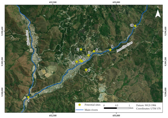
Figure 3.
Potential sites location: (1) Union of the Calera River and Amarillo River, (2) Museo Mineralógico Magner Turner, (3) Escultura en honor al minero, (4) Conjunto de casas patrimoniales, (5) Estadio de oro, (6) San José hill, (7) Vestigios de la minera SADCO, (8) Jesús Ángel waterfall, (9) La Chorrera tourist viewpoint, y (10) “Aguas calientes” nature spring.
To complement the geological interest sites, six sites of tourist interest were defined within the field trip, including biodiversity, cultural, and historical values. The selected potential geosites represent important geological processes of the mining district. On the other hand, the sites of natural, cultural, and historical interest were defined based on the importance of the tourist interest of the studied area.
Table 3 presents the main characteristics of the surveyed sites (potential geosites and tourist interest sites) (Figure 4), which lays the basis for the subsequent quantitative evaluation.
Table 3.
List of potential sites in the study area and general characteristics.
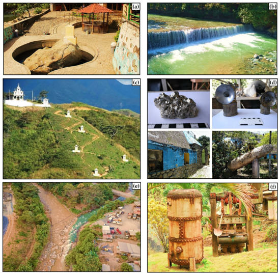
Figure 4.
Examples of potential sites in the study area: (a) “Aguas calientes” nature spring, (b) La Chorrera tourist viewpoint, (c) San José hill, (d) Museo Mineralógico Magner Turner, (e) union of the Calera River and Amarillo River, (f) Vestigios de la minera SADCO.
4.2. Proposed Geotouristic Route (GR)
The proposed GR is characterised by a route along the Yellow River, specifically the last 5 km through the city. It will be 10 potential sites: Four sites of geological interest and six of tourist interest (Figure 5). The distance between each site is short, with trips from one site to another ranging between 5–10 min and stops of approximately 30 min. The total route in a tourist visit would address a maximum time of 7 h, in which tourists have restaurant services, parking lots, and accommodation.
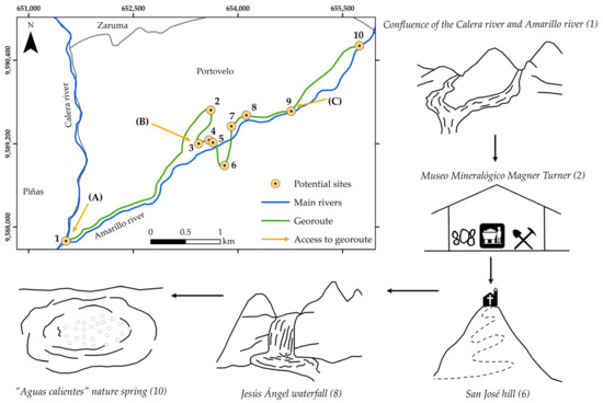
Figure 5.
Proposed geotouristic route along the Amarillo River. Access to georoute: (A) Access from Piñas, (B) access from Zaruma, and (C) access from Loja.
The GR has three main accesses (Figure 5): Access A from the Piñas canton, B from the Zaruma canton, and C from the Loja province. Paved roads in good condition characterise all of the accesses with capacity from bicycles to tourist transport buses.
According to the fieldwork itineraries, the sites contained in the route have an average capacity of 20 people (tourists) who can visit each site simultaneously. It is important to note that this itinerary is designed simultaneously with a project to recover the banks of the Yellow River, in which the municipal authorities are planning the construction of a boardwalk conditioned for tourism, which runs through the proposed area as a geotouristic route. Specifically, the tourist will enjoy an itinerary with the necessary conditions for an agreeable journey.
4.3. Geosites Assessment
The geosites assessment (4) by the Brilha method (Figure 6) reflects that two present values are greater than 200/400 in evaluating scientific interest. The highest-rated geosite within the GR corresponds to Museo Mineralógico Magner Turner, considered on this route due to its previous assessment (330/400) made by Turner-Carrión et al. [64], and its proximity to the river. The geosite “Aguas Calientes” nature spring is the second most scored (285/400). This geosite represents one of the few examples of hot spring points in the studied area without active volcanism, partially conditioned to tourism. Both geosites are of high scientific interest and considered for future research studies. Regarding the educational and tourist potential (values greater than 230), it is possible to observe that all of the geosites present geological characteristics in good conditions with a broad compression level of geological processes. Furthermore, due to their location (urban area), these sites have good accessibility, association with natural, cultural, and historical values, and the presence of lodging services, parking, and restaurants.
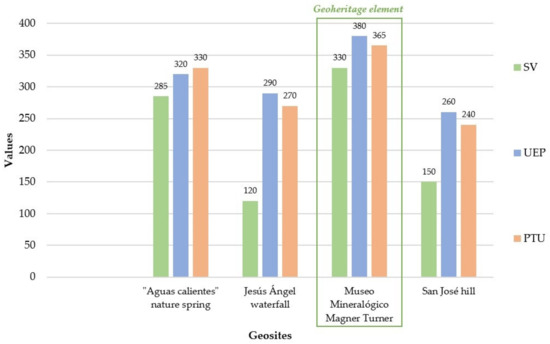
Figure 6.
Results obtained from assessing the scientific (SV), educational (UEP), and tourist (PTU) values of potential geosites by the Brilha method. The results of the Museo Mineralógico Magner Turner assessment correspond to the assessment carried out by Turner-Carrión et al. [64].
Furthermore, due to its occurrence in an urban area, the results obtained from the DR evaluation indicate that the geosites present a risk classified as low to moderate (Figure 7), according to the method used (Table 1). Of these geosites, the Jesús Ángel waterfall is the site with the highest DR, mainly due to its size, proximity to potentially degrading human activities, such as illegal artisanal mining, and scant legal control without conservation plans.
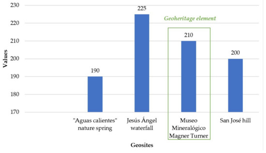
Figure 7.
Results obtained from the degradation risk (DR) assessment of geosites by the Brilha method. DR assessment of the Museo Mineralógico Magner Turner corresponds to the assessment carried out by Turner-Carrión et al. [64].
4.4. Geotouristic Route Assessment
The assessment by the GtRAM method reflects that the route has an average value of 3.21/5, classified as high tourist interest. Within the GR, six sites of the proposed GR present an interest classified as high (values greater than 3) (Figure 8), highlighting the Museo Mineralógico Magner Turner geosite as the site of significant interest (4.33/5). This geosite is characterised by its adaptation to tourism. It offers facilities currently used as destinations for national and international tourist visits and its high geological, cultural, and historical values.
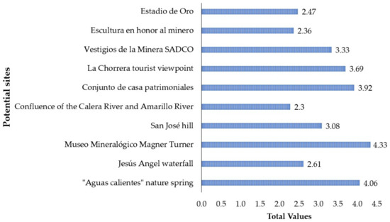
Figure 8.
Results from the GtRAM assessment of the potential geosites and tourist interest sites proposed by the GR.
The four remaining sites present values classified as medium (2–2.9), within which the “Union of the Calera River and Amarillo River” is the site with the lowest score (2.31/5). The site is a rare morphological feature in the area that draws the attention of local and national tourists. However, the Calera River is most affected by mining contamination and mineral processing plants. Despite its uniqueness, the lack of legal protection has led to high water and air pollution levels.
4.5. SWOT Analysis Matrix
The SWOT matrix used in this study made it possible to propose specific strategies for the RM and its environment (Table 4) through the combination of internal (Strengths and Weaknesses) and external (Opportunities and Threats) characteristics that involve geological, tourist, cultural, legislative aspects, management, and geoconservation. Furthermore, the strategies proposed here will guarantee the responsible use of resources, including actions focused on conserving, conditioning, and disseminating a municipality belonging to the Ruta del Oro Geopark Project. Finally, this analysis lays the foundations for a comprehensive alliance management plan and academic, business, municipal, and citizen collaboration.
Table 4.
Strengths, weaknesses, opportunities, and threats (SWOT) matrix analysis of GR proposed. The SWOT combines the internal environment (strengths and weaknesses) identified by numbers 1 to 6 and the external environment (opportunities and threats) identified by letters (a) to (f).
5. Interpretation of Results and Discussion
The methodology proposed in this study allowed for the establishment of a geotouristic route (GR) in a mining area (Portovelo city) as an alternative for the socioeconomic development of the population and its surroundings in the face of problems related to unregulated artisanal mining activity. The route included four geosites and six tourist interest sites. Considering that quantitative assessment processes support management, protection, and promotion strategies [96,97], the geosites with the highest score in the assessment carried out in this study by Carrión Mero et al. [46] were selected for this study. These geosites were assessed by the Brilha method [1] to: (i) Expand and complement the perspective of the tourist value they present, (ii) better discriminate the weak parameters that need to be strengthened in the context of RM, and (iii) strengthen the assessment criteria and reduce the subjectivity of the quantitative assessment methods of geosites using two or more methodologies. The tourist interest sites contemplated by the GR are characterised by their current use in local and national tourism due to their natural, cultural, and historical wealth. Based on the integration of geosites and tourist interest sites, the GR was assessed through the GtRAM method [47], which allowed for the determination of its tourism potential.
The results obtained by the Brilha method indicate that the geosites have a high scientific, tourist, and educational values (Figure 6), following a trend, such as the evaluations obtained by Carrión Mero et al. [46]. The Museo Mineralógico Magner Turner has the highest score, according to the assessment carried out by Turner-Carrión et al. [64]. It is characterised as the only specimen in the area that includes a variety of representative mineralogical samples of the mining district, mines underground in situ, and equipment used in the old artisan exploitation of the area. Within the assessment carried out in this study, “Aguas Calientes” nature spring is the second most punctuated geosite of the GR, with unusual geological characteristics in the area and located next to the Amarillo River. This geosite has been the focus of scientific studies related to the characterisation of hot springs in Ecuador (e.g., [87,88]), and their potential for use within geotourism in the area (e.g., [46,47]). The facilities consist of basic services, such as water, electricity, bathrooms, telephone coverage, internet, and food. “Aguas Calientes” nature spring is one of the most visited tourist sites in the canton, which needs promotion and conditioning strategies focused on its geological and geoconservation interest. Its geological potential has allowed for the development of scientific studies related to the geosites assessment [45,46,47,60,64,98,99] and with the geology of the area [59,67,74,77,78,80,92,100,101,102].
If the tourist and academic potential are analysed, the geosites present clear geological elements for all of the publics, associated with natural, cultural, and historical values less than 5 km away, which are currently used as destinations for national tourist campaigns. Furthermore, all of the geosites are in the urban area, crossing the Portovelo city, making them easily accessible with an infrastructure (lodging services, restaurants, and transportation) favouring tourism development [103]. According to Rivas et al. [104], geosites with adequate accessibility and good observation conditions improve the potential for use, allowing for the unique geological and geomorphological characteristics through observation, examination, description, and sampling [105]. Regarding the use limitations of geosites, they can generally be used by students and tourists without exception, ensuring users’ safety with emergency services located less than 5 km away. On the other hand, the vulnerability parameter has made it possible to visualise the possibility of deterioration of the secondary geological elements due to anthropic activity, which in the studied area corresponds to illegal mining and activities linked to mineral processing. In addition, it is important to note that the singularity parameter included in the tourism value of the Brilha method allowed for the determination of the tourism potential of each geosite based on the presence of unique or unusual geological characteristics within the region or country. In the case of the GR, the Museo Mineralógico Magner Turner and the “Aguas Calientes” nature spring represent the most attractive geosites due to their rarity within the studied area and its surroundings.
The DR results indicate that the geosites present a risk classified as low to moderate. Despite the existing low population density, its location in an urban area, limited area, and proximity to mining and mineral processing activities have repercussions on the integrity of the geosites. According to Brilha [1], the accessibility parameter is an advantage and a disadvantage at the same time. The advantage is that good accessibility to the site attracts a larger number of tourists. However, an excess of tourists in the same geosite carries a risk of degradation. These problems in the studied area are presented by the absence of regulations focused on geoconservation. This planning and conservation policy would strengthen the link between human activity and the sustainable use of geological elements [106].
The assessment, by the GtRAM method, reflects that the GR presents a high tourist interest (3.21/5). The evaluation of the route proposed in this study is lower than the evaluation proposed by Carrión-Mero et al. [47], called “Ruta de la Geodiversidad”, with a value of 3.74/5, which includes sites in the Zaruma and Portovelo cantons. This is mainly due to the number of sites considered (in this case, 10 sites) and the punctual route focused solely on the Portovelo canton with very short distances between the sites. Sixty percent of the sites were considered to have ratings classified as high to very high tourist interest. These sites have favourable conditions for tourism (e.g., paved access roads, parking spaces, basic services), adding cultural, heritage, and historical values that make them destinations for local and regional tourism campaigns. The route proposed here offers a scientific basis with geotourism potential for the current project in the process of execution called “Recuperación de las riberas del río Calera”. In this municipal project, the authorities seek to condition a tourist boardwalk that runs the final 4 km of the river that crosses the city with institutional and academic support. Moreover, the project aims to develop cultural and tourist awareness campaigns dealing with illegal mining, which causes some damage and problems in the sector.
To strengthen the quantitative assessment and management plans of potential geosites, the participation of people from outside the geoscientific field is important [107]. For this reason, a SWOT analysis was developed with the participation of the community, municipal authorities, tourism managers, and geo-experts. The analysis made it possible to identify the main strengths, weaknesses, opportunities, and threats for planning management strategies for the RM and its surroundings. The SWOT analysis mainly reflects a high potential for developing tourist activities, using its geological potential, with natural and historical interest sites in its surroundings. According to the analysis group, the proposed route represents a unique itinerary for the Ruta del Oro Geopark Project characterised by its proximity to basic services for tourists. The route would represent a source of economic income for the studied area to improve the local productive matrix. However, it is important to highlight the need for laws focused on geoconservation and reduce the environmental pollution. The scarcity of this type of regulation represents a risk for the sites and their inhabitants. Furthermore, this analysis exposes the need for financing and municipal and business cooperation to execute conditioning projects. Of the strategies proposed in the SWOT analysis, the following stand out:
- -
- Execution of conditioning projects with municipal, enterprise, and academic intervention, including the participation of the inhabitants along the route that promotes tourism and improves the inhabitants’ quality of life.
- -
- Development of geological characterisation studies proposed implementing digital platforms for geotourism promotion at the local, national, and international levels.
- -
- Promote community participation in processes related to the Ruta del Oro Geopark Project, highlighting the importance of their participation in commercial and geoconservation activities within the project.
- -
- Inclusion of legal regulations and strengthening of alliances through municipal ordinances of institutional and financial cooperation. These measures are essential to ensure the operability of the geopark project.
- -
- Execute environmental recovery projects for geosites and complementary sites affected by mining contamination.
- -
- Develop training and awareness plans for integrating industrial mining development and its effects on the environment.
In general, the methodology proposed in this study can be used to define new geotouristic routes in the context of the Ruta del Oro Geopark Project as a potential tool for obtaining economic income without the need to exploit a natural resource [44,108,109], considering geoconservation strategies and geotourism development. Furthermore, this approach can be improved through the individual geological characterisation of each geosite and an impact study on the geological heritage due to conditioning works.
6. Conclusions
The quantitative evaluation methods used in this study (Brilha for geosites and GtRAM for geosites and other sites) demonstrated their tourism potential. The results obtained show high scientific, academic, and tourist values of the geosites and, consequently, of the proposed itinerary. To complement this analysis, the evaluation made it possible to define weak parameters that must be corrected and propose ways to correct them (e.g., installation of interpretive panels, including a tour guide, geological characterisation studies). All of this guarantees the route’s viability and efficiency as an element for the area’s sustainable development.
The qualitative analysis (SWOT) focused on three main aspects: (i) The geological, natural, cultural, and historical potential of the area to strengthen tourism, (ii) conditioning measures for geosites and sites of tourist interest, (iii) inter-institutional cooperation and community within the framework of promotion and conservation, and (iv) implementation of regulations that regulate potentially degrading activities in the study area and its surroundings.
The proposed study constitutes a process of assessing geodiversity elements with scientific value in situ (potential geosites) and ex situ (geoheritage elements), selected as sites worthy of conservation and potential use in geotourism development. The community, municipality, and the knowledge of geo-experts strengthen the evaluation process, guaranteeing a sustainable management and promotion plan.
Author Contributions
Conceptualisation, P.C.-M., G.H.-F., M.T.-C. and M.A.-A.; methodology, P.C.-M., G.H.-F., M.T.-C., M.A.-A., G.B.-M. and E.B.; investigation, P.C.-M., M.T.-C., G.B.-M. and N.P.-S.; writing—original draft preparation, M.A.-A., G.B.-M. and E.B.; writing—review and editing, P.C.-M., G.H.-F., M.T.-C., M.A.-A., G.B.-M., N.P.-S. and E.B.; supervision, P.C.-M. and E.B. All authors have read and agreed to the published version of the manuscript.
Funding
This research was funded by the ESPOL Polytechnic University research project called “Registry of geological and mining heritage and its impact on the defense and preservation of geodiversity in Ecuador”, CIPAT–01–2018 and “Propuesta de Geoparque Ruta del Oro y su incidencia en el desarrollo territorial”, CIPAT-02-2018.
Institutional Review Board Statement
Not applicable.
Informed Consent Statement
Not applicable.
Data Availability Statement
Not applicable.
Acknowledgments
This work is based on previous initiatives sponsored by the Red Minería XXI (CYTED: 407310RT0402, IGME) and Proyecto Rutas Mineras y Sostenibilidad (RUMYS). We would like to thank Paulina Morales (Vicealcaldesa de Portovelo), Angel Orellana, and Roy Siguenza in carrying out the SWOT analysis and photographs of the geosites. We would also like to thank the editorial office for the editorial handling and two anonymous reviewers for their constructive comments and corrections.
Conflicts of Interest
The authors declare no conflict of interest.
References
- Brilha, J.B. Inventory and Quantitative Assessment of Geosites and Geodiversity Sites: A Review. Geoheritage 2015, 8, 119–134. [Google Scholar] [CrossRef] [Green Version]
- Pereira, E.O.; Ruchkys, Ú. Quantificação e análise da geodiversidade aplicada ao geoturismo na área de proteção ambiental sul da região metropolitana de belo horizonte, minas gerais. Raega-O Espaço Geográfico Em Análise 2016, 37, 207. [Google Scholar] [CrossRef]
- Ríos-Reyes, C.A.; Jaraba, D.C.M.; Castellanos-Alarcón, O.M. Geotourism Potential and Challenges of the Coastal Region Around Santa Marta (Colombia): A Novel Strategy for Socioeconomic Development. Cuad. Geogr. Rev. Colomb. Geogr. 2021, 30, 106–124. [Google Scholar] [CrossRef]
- Gray, M. Defining Geodiversity. In Geodiversity: Valuing and Conserving Abiotic Nature; John Wiley & Sons: Chichester, UK, 2004; pp. 1–9. [Google Scholar]
- Crisp, J.R.; Ellison, J.C.; Fischer, A. Current trends and future directions in quantitative geodiversity assessment. Prog. Phys. Geogr. Earth Environ. 2020, 45, 514–540. [Google Scholar] [CrossRef]
- Ruban, D. Geodiversity as a precious national resource: A note on the role of geoparks. Resour. Policy 2017, 53, 103–108. [Google Scholar] [CrossRef]
- Carcavilla, L.; López Martínez, J.; Durán Valsero, J. Patrimonio Geológico y Geodiversidad: Investigación, Conservación, Gestión Y Relación Con Los Espacios Naturales Protegidos; IGME: Madrid, Spain, 2007. [Google Scholar]
- Erikstad, L. Geoheritage and geodiversity management—The questions for tomorrow. Proc. Geol. Assoc. 2012, 124, 713–719. [Google Scholar] [CrossRef]
- Brilha, J. Geoheritage: Inventories and evaluation. In Geoheritage; Elsevier: Amsterdam, The Netherlands, 2018; pp. 69–85. [Google Scholar]
- Gray, M. Geodiversity: The Backbone of Geoheritage and Geoconservation; Elsevier Inc.: Amsterdam, The Netherlands, 2018; ISBN 9780128095423. [Google Scholar]
- Jakubowski, K.J. Geological Heritage and Museums. In Proceedings of the Geological Heritage Concept, Conservation and Protection Policy in Central Europe, Cracow, Poland, 3–4 October 2003; Volume 13, pp. 21–28. [Google Scholar]
- Reis, J.; Póvoas, L.; Barriga, F.; Lopes, C.; Santos, V.F.; Ribeiro, B.; Cascalho, J.; Pinto, A. Science Education in a Museum: Enhancing Earth Sciences Literacy as a Way to Enhance Public Awareness of Geological Heritage. Geoheritage 2014, 6, 217–223. [Google Scholar] [CrossRef]
- Palacio-Prieto, J.L. Geosites, geomorphosites and geoparks: Importance, actual situation and perspectives in Mexico. Investig. Geográficas 2013, 2013, 24–37. [Google Scholar] [CrossRef] [Green Version]
- Allan, M.; Dowling, R.; Sanders, D. The motivations for visiting geosites: The case of Crystal Cave, Western Australia. Geoj. Tour Geosites 2015, 15, 142–153. [Google Scholar]
- Herrera-Franco, G.; Montalván-Burbano, N.; Carrión-Mero, P.; Apolo-Masache, B.; Jaya-Montalvo, M. Research Trends in Geotourism: A Bibliometric Analysis Using the Scopus Database. Geosciences 2020, 10, 379. [Google Scholar] [CrossRef]
- Herrera-Franco, G.; Erazo, K.; Mora-Frank, C.; Carrión-Mero, P.; Berrezueta, E. Evaluation of a Paleontological Museum as Geosite and Base for Geotourism. A Case Study. Heritage 2021, 4, 1208–1227. [Google Scholar] [CrossRef]
- Prosser, C.D.; Díaz-Martínez, E.; Larwood, J.G. The Conservation of Geosites. In Geoheritage; Elsevier: Amsterdam, The Netherlands, 2018; pp. 193–212. [Google Scholar] [CrossRef]
- Forte, J.P.; Brilha, J.; Pereira, D.; Nolasco, M. Kernel Density Applied to the Quantitative Assessment of Geodiversity. Geoheritage 2018, 10, 205–217. [Google Scholar] [CrossRef] [Green Version]
- García-Cortés, Á.; Carcavilla Urquí, L.; Apoita Mugarza, B.; Arribas, A.; Bellido, F.; Barrón, E.; Delvene, G.; Díaz-Martínez, E.; Díez, A.; Durán, J.J.; et al. Documento Metodológico Para la Elaboración del Inventario Español de Lugares de Interés Geológico (IELIG). Propuesta para la Actualización Metodológica; Instituto Geológico y Minero de España: Madrid, Spain, 2013; pp. 1–64. [Google Scholar]
- Kozowski, S. Geodiversity. The concept and scope of geodiversity. Prz. Geol. 2004, 52, 833–837. [Google Scholar]
- Miljković, Ð.; Božić, S.; Miljković, L.; Marković, S.B.; Lukić, T.; Jovanović, M.; Bjelajac, D.; Vasiljević, Đ.A.; Vujičić, M.D.; Ristanović, B. Geosite Assessment Using Three Different Methods; a Comparative Study of the Krupaja and the Žagubica Springs—Hydrological Heritage of Serbia. Open Geosci. 2018, 10, 192–208. [Google Scholar] [CrossRef]
- Quesada-Román, A.; Pérez-Umaña, D. State of the Art of Geodiversity, Geoconservation, and Geotourism in Costa Rica. Geosciences 2020, 10, 211. [Google Scholar] [CrossRef]
- Reynard, E.; Fontana, G.; Kozlik, L.; Scapozza, C. A method for assessing scientific and additional values of geomorphosites. Geogr. Helv. 2007, 62, 148–158. [Google Scholar] [CrossRef]
- Serrano, E.; Ruiz-Flaño, P. Geodiversity: A theoretical and applied concept. Geogr. Helv. 2007, 62, 140–147. [Google Scholar] [CrossRef]
- Vujičić, M.D.; Vasiljević, D.A.; Marković, S.B.; Hose, T.A.; Lukić, T.; Hadžić, O.; Janićević, S. Preliminary geosite assessment model (GAM) and its application on Fruška gora mountain, potential geotourism destination of Serbia. Acta Geogr. Slov. 2011, 51, 361–376. [Google Scholar] [CrossRef]
- Bollati, I.; Lenz, B.C.; Zanoletti, E.; Pelfini, M. Geomorphological mapping for the valorization of the alpine environment. A methodological proposal tested in the Loana Valley (Sesia Val Grande Geopark, Western Italian Alps). J. Mt. Sci. 2017, 14, 1023–1038. [Google Scholar] [CrossRef]
- Larwood, J.; Prosser, C. Geotourism, Conservation and Society Earth heritage conservation in the UK—Its status Conservation and geotourism—Some examples from the UK. Geol. Balc. 1998, 28, 97–100. [Google Scholar]
- Newsome, D.; Dowling, R.K. Setting an agenda for geotourism. In Geotourism: The Tourism of Geology and Landscape; Newsome, D., Dowling, R.K., Eds.; Goodfellow Publishers Limited: Oxford, UK, 2010; pp. 1–12. [Google Scholar]
- Hose, T.A.; Vasiljević, D.A. Defining the Nature and Purpose of Modern Geotourism with Particular Reference to the United Kingdom and South-East Europe. Geoheritage 2012, 4, 25–43. [Google Scholar] [CrossRef]
- Dowling, R.K. Global Geotourism—An Emerging Form of Sustainable Tourism. Czech J. Tour. 2014, 2, 59–79. [Google Scholar] [CrossRef] [Green Version]
- Hose, T. Geoheritage and Geotourism: A European Perspective; Boydell & Brewer: Woodbridge, UK, 2016. [Google Scholar]
- Hose, T. European geotourism–geological interpretation and geoconservation promotion for tourists. In Geological Heritage: Its Conservation and Management; Barettino, D., Wimbledon, W.A.P., Gallego, E., Eds.; Instituto Tecnologico Geominero de Espana: Madrid, Spain, 2000; pp. 127–146. [Google Scholar]
- Słomka, T.; Kicińska-Świderska, A. The basic concepts of geotourism. Geoturystyka/Geotourism 2004, 1, 5–7. [Google Scholar]
- Joyce, E.B. Geological heritage of Australia: Selecting the best for Geosites and World Heritage, and telling the story for geotourism and Geoparks. ASEG Ext. Abstr. 2006, 2006, 1–4. [Google Scholar] [CrossRef]
- Newsome, D.; Dowling, R.K. The future of geotourism where to from here. In Geotourism: The Tourism of Geology and Landscape; Newsome, D., Dowling, R.K., Eds.; Goodfellow Publishers Limited: Wallingford, UK, 2010. [Google Scholar]
- Hose, T.A. The English Origins of Geotourism (as a Vehicle for Geoconservation) and Their Relevance to Current Studies. Acta Geogr. Slov. 2011, 51, 343–359. [Google Scholar] [CrossRef] [Green Version]
- Newsome, D.; Dowling, R. Geoheritage and Geotourism. In Geoheritage: Assessment, Protection, and Management; Reynard, E., Brilha, J., Eds.; Elsevier: Amsterdam, The Netherlands, 2018; pp. 305–321. [Google Scholar]
- Kubalíková, L. Assessing Geotourism Resources on a Local Level: A Case Study from Southern Moravia (Czech Republic). Resources 2019, 8, 150. [Google Scholar] [CrossRef] [Green Version]
- Martini, G.; Alcalá, L.; Brilha, J.; Iantria, L.; Sá, A.A.; Tourtellot, J. Reflections about the geotourism concept. In Proceedings of the 11th European Geoparks Conference, Arouca Geopark, Portugal, 19–21 September 2012; Sá, A.A., Rocha, D., Paz, A., Correia, V., Eds.; 2012; pp. 187–188. [Google Scholar]
- Herrera-Franco, G.; Carrión-Mero, P.; Alvarado, N.; Morante-Carballo, F.; Maldonado, A.; Caldevilla, P.; Briones-Bitar, J.; Berrezueta, E. Geosites and Georesources to Foster Geotourism in Communities: Case Study of the Santa Elena Peninsula Geopark Project in Ecuador. Sustainability 2020, 12, 4484. [Google Scholar] [CrossRef]
- Herrera, G.; Carrión, P.; Briones, J. Geotourism potential in the context of the geopark project for the development of santa elena province, ecuador. WIT Trans. Ecol. Environ. 2018, 217, 557–568. [Google Scholar] [CrossRef] [Green Version]
- Castanera, D.; Pascual, C.; Canudo, J.I.; Barco, J.L. Bringing Together Research, Geoconservation and Reaching a Broad Public in the Form of a Geotourism Project: The Ichnite Route of Soria (Spain). Geoheritage 2017, 10, 393–403. [Google Scholar] [CrossRef] [Green Version]
- Carrión-Mero, P.; Loor-Oporto, O.; Andrade-Ríos, H.; Herrera-Franco, G.; Morante-Carballo, F.; Jaya-Montalvo, M.; Aguilar-Aguilar, M.; Torres-Peña, K.; Berrezueta, E. Quantitative and Qualitative Assessment of the “El Sexmo” Tourist Gold Mine (Zaruma, Ecuador) as A Geosite and Mining Site. Resources 2020, 9, 28. [Google Scholar] [CrossRef] [Green Version]
- Mata-Perelló, J.; Carrión, P.; Molina, J.; Villas-Boas, R. Geomining Heritage as a Tool to Promote the Social Development of Rural Communities. In GeoheritageIn Geoheritage; Elsevier: Amsterdam, The Netherlands, 2018; pp. 167–177. ISBN 9780128095423. [Google Scholar] [CrossRef]
- Franco, G.H.; Mero, P.C.; Carballo, F.M.; Narváez, G.H.; Bitar, J.B.; Torrens, R.B. Strategies for the development of the value of the mining-industrial heritage of the Zaruma-Portovelo, ecuador, in the context of a geopark project. Int. J. Energy Prod. Manag. 2020, 5, 48–59. [Google Scholar] [CrossRef]
- Mero, P.C.; Franco, G.H.; Briones, J.; Caldevilla, P.; Domínguez, P.C.; Berrezueta, E. Geotourism and Local Development Based on Geological and Mining Sites Utilization, Zaruma-Portovelo, Ecuador. Geosciences 2018, 8, 205. [Google Scholar] [CrossRef]
- Carrión-Mero, P.; Herrera-Narváez, G.; Herrera-Franco, G.; Sánchez-Zambrano, E.; Mata-Perelló, J.; Berrezueta, E. Assessment and Promotion of Geotouristic and Geomining Routes as a Basis for Local Development: A Case Study. Minerals 2021, 11, 351. [Google Scholar] [CrossRef]
- Martínez-Graña, A.M.; Serrano, L.; González, L.S.; Dabrio, C.J.; Legoinha, P. Sustainable geotourism using digital technologies along a rural georoute in Monsagro (Salamanca, Spain). Int. J. Digit. Earth 2016, 10, 121–138. [Google Scholar] [CrossRef]
- Figueroa-Sterquel, R.; Negrete-Sepúlveda, J.; Silva-Marambio, A.; Cosio, F. New Routes of Geotourism for the La Campana–Peñuelas Biosphere Reserve, Chile. In Global Geographical Heritage, Geoparks and Geotourism. Advances in Geographical and Environmental Sciences; Springer: Singapore, 2021; pp. 285–306. [Google Scholar]
- Arenas-Martija, A.; Orrego-Araya, J.; Ortiz-Pavéz, C.; Gajardo-Tapia, C.; Zanetta-Colombo, N.; Inzunza-López, K.; Cisternas-Silva, N.; Córdova-Veas, C.; Goehler-Marchant, A.M.; Báez-Córdova, N.; et al. Collaborative Creation of Educational Geo Routes: A Strategy for Teaching and Learning Sciences and Geography, Puchuncaví, Chile. In Global Geographical Heritage, Geoparks and Geotourism. Advances in Geographical and Environmental Sciences; Springer: Singapore, 2021; pp. 449–483. [Google Scholar]
- Lazzari, M.; Grano, M. Geo-milltour: Innovative geo-touristic routes along the historic watermills in Basilicata (Southern Italy). In Proceedings of the International Conference on Geotourism, Mining Tourism, Sustainable Development, and Environmental Protection, Firenze, Italy, 18–20 October 2016; Ugolini, F., Marchi, V., Trampetti, S., Pearmutter, D., Raschi, A., Eds.; IBIMET-CNR: Florence, Italy, 2016; pp. 84–89. [Google Scholar]
- Del Lama, E.A.; de La Corte Bacci, D.; Martins, L.; da Glória Motta Garcia, M.; Dehira, L.K. Urban Geotourism and the Old Centre of São Paulo City, Brazil. Geoheritage 2015, 7, 147–164. [Google Scholar] [CrossRef]
- Pereira, M.B.; Ferreira, A.C.; Rocha, L.C. Trilha interpretativa geoturística na Serra de São José no entorno da estrada real/MG. Anu. Do Inst. Geociencias 2012, 35, 165–172. [Google Scholar] [CrossRef]
- Carrion-Mero, P. Proyecto Rumys: Cooperación y Sostenibilidad. In La Plata en Iberoamérica, Siglos XVI al XIX: Congreso Internacional; Universidad de León: León, Spain, 2008; pp. 687–700. [Google Scholar]
- González-Martínez, A.; Carvajal Gómez, D.J. Pasivos ambientales mineros y su valorización como recurso patrimonial. Ejemplo de actuaciones en la Comarca de Tharsis (Faja Pirítica Ibérica). In Taller Sostenibilidad; CETEM: Río de Janeiro, Brazil, 2013; pp. 5–29. [Google Scholar]
- Pires, M. A “Estrada Real” e a história do processo de construção de roteiros turísticos no estado de Minas Gerais. Rev. Sobre Tur. Y Desarro. Local Sosten. 2017, 10, 1–10. [Google Scholar]
- Sánchez-Cortez, J.L. Conservation of geoheritage in Ecuador: Situation and perspectives. Int. J. Geoheritage Park. 2019, 7, 91–101. [Google Scholar] [CrossRef]
- Berrezueta, E.; Sánchez-Cortez, J.L.; Aguilar-Aguilar, M. Inventory and Characterization of Geosites in Ecuador: A Review. Geoheritage 2021, 13, 1–17. [Google Scholar] [CrossRef]
- Berrezueta, E.; Ordóñez-Casado, B.; Bonilla, W.; Banda, R.; Castroviejo, R.; Carrión, P.; Puglla, S. Ore Petrography Using Optical Image Analysis: Application to Zaruma-Portovelo Deposit (Ecuador). Geosciences 2016, 6, 30. [Google Scholar] [CrossRef] [Green Version]
- Berrezueta, E.; Domínguez-Cuesta, M.; Carrión, P.; Berrezueta, T.; Herrero, G. Propuesta metodológica para el aprovechamiento del patrimonio geológico minero de la zona Zaruma-Portovelo (Ecuador). Trab. Geol. 2006, 26, 103–109. [Google Scholar]
- Ayala, D.; Delgado, J.; López, F.; Boski, T.; Calderón, E. Preliminary evaluation of a passive treatment for mine tailings in Portovelo, El Oro, Ecuador. In Proceedings of the 27th International Applied Geochemistry Symposium, Tucson, AZ, USA, 20–24 April 2015; pp. 1–12. [Google Scholar]
- Rodríguez, J.D.; Brioso, C.B.; Boski, T. Caracterización de residuos mineros y diseño preliminar de un sistema de acopio controlado en el distrito minero de Zaruma-Portovelo (SE Ecuador). Geogaceta 2018, 64, 135–138. [Google Scholar]
- Marshall, B.G.; Veiga, M.M.; Da Silva, H.A.M.; Guimarães, J.R.D. Cyanide Contamination of the Puyango-Tumbes River Caused by Artisanal Gold Mining in Portovelo-Zaruma, Ecuador. Curr. Environ. Health Rep. 2020, 7, 303–310. [Google Scholar] [CrossRef] [PubMed]
- Turner-Carrión, M.; Carrión-Mero, P.; Turner-Salamea, I.; Morante-Carballo, F.; Aguilar-Aguilar, M.; Zambrano-Ruiz, K.; Berrezueta, E. A Mineralogical Museum as a Geotourism Attraction: A Case Study. Minerals 2021, 11, 582. [Google Scholar] [CrossRef]
- Zarroca, M.; Linares, R.; Velásquez-López, P.C.; Roqué, C.; Rodríguez, R. Application of electrical resistivity imaging (ERI) to a tailings dam project for artisanal and small-scale gold mining in Zaruma-Portovelo, Ecuador. J. Appl. Geophys. 2015, 113, 103–113. [Google Scholar] [CrossRef]
- Oliva, A.; Ruíz, A.; Gallardo, R. Terrain instability in areas of mining activity: Cse Zaruma city. Ecuador. Rev. Redes Ing. 2017, 8, 69–81. [Google Scholar]
- Calle, J. Geología regional de Zaruma-Portovelo y consideraciones ambientales del sector. In El Patrimonio Geominero en el Contexto de la Ordenación del Territorio; Martins, L., Carrión, P., Eds.; ESPOL: Guayaquil, Ecuador, 2005; pp. 307–320. ISBN 9978-44-615-. [Google Scholar]
- Sauer, W. Geología del Ecuador; Editorial Talleres Gráficos del Ministerio de Educación: Quito, Ecuador, 1965. [Google Scholar]
- González-Carrasco, V.; Velasquez-Lopez, P.C.; Olivero-Verbel, J.; Pájaro-Castro, N. Air Mercury Contamination in the Gold Mining Town of Portovelo, Ecuador. Bull. Environ. Contam. Toxicol. 2011, 87, 250–253. [Google Scholar] [CrossRef]
- Jácome, M.C.; Martinez-Graña, A.M.; Valdés, V. Detection of Terrain Deformations Using InSAR Techniques in Relation to Results on Terrain Subsidence (Ciudad de Zaruma, Ecuador). Remote Sens. 2020, 12, 1598. [Google Scholar] [CrossRef]
- Schütte, P.; Chiaradia, M.; Barra, F.; Villagómez, D.; Beate, B. Metallogenic features of Miocene porphyry Cu and porphyry-related mineral deposits in Ecuador revealed by Re-Os, 40Ar/39Ar, and U-Pb geochronology. Miner. Deposita 2011, 47, 383–410. [Google Scholar] [CrossRef] [Green Version]
- PRODEMINCA. Depósitos porfídicos y epi-mesotermales relacionados con intrusiones de las Cordilleras Occidental y Real. Evaluación Dist. Min. Del Ecuad. 2000, 4, 36–55. [Google Scholar]
- PRODEMINCA. Depósitos epitermales en la Cordillera Andina. In Evaluación de Distritos Mineros del Ecuador; UCP PRODEMINCA Proyecto MEM BIRF: Quito, Ecuador, 2000; Volume 2, pp. 36–55. [Google Scholar]
- Schütte, P.; Chiaradia, M.; Beate, B. Petrogenetic Evolution of Arc Magmatism Associated with Late Oligocene to Late Miocene Porphyry-Related Ore Deposits in Ecuador. Econ. Geol. 2010, 105, 1243–1270. [Google Scholar] [CrossRef]
- Aspden, J.A.; Bonilla, W.; Duque, P. The El Oro Metamorphic Complex, Ecuador: Geology and Economic Mineral Deposits; British Geological Survey: Nottingham, UK, 1995; Volume 67, p. 63. [Google Scholar]
- Riel, N.; Martelat, J.-E.; Guillot, S.; Jaillard, E.; Monié, P.; Yuquilema, J.; Duclaux, G.; Mercier, J. Fore arc tectonothermal evolution of the El Oro metamorphic province (Ecuador) during the Mesozoic. Tectonics 2014, 33, 1989–2012. [Google Scholar] [CrossRef]
- Van Thournout, F.; Salemink, J.; Valenzuela, G.; Merlyn, M.; Boven, A.; Muchez, P. Portovelo: A volcanic-hosted epithermal vein-system in Ecuador, South America. Miner. Depos. 1996, 31, 269–276. [Google Scholar] [CrossRef]
- Berrezueta, E.; Ordóñez-Casado, B.; Espinoza-Santos, C.; Loayza-Ramírez, J.; Carrión-Mero, P.; Morante-Carvallo, F.; Bonilla, W. Caracterización mineralógica y petrográfica de las vetas Vizcaya, Octubrina y Gabi del yacimiento aurífero epitermal Zaruma-Portovelo, Ecuador. Boletín Geológico y Min. 2021, 132, 421–437. [Google Scholar] [CrossRef]
- Paladines, A.P.; Rosero, G. Zonificación Mineralogénica del Ecuador; Laser Editores S.A.: Quito, Ecuador, 1996. [Google Scholar]
- Vikentyev, I.; Banda, R.; Tsepin, A.; Prokofiev, V.; Vikentyeva, O. Mineralogy and formation conditions of Portovelo-Zaruma gold-sulphide vein deposit, Ecuador. Geochemistry. Mineral. Petrol. 2005, 43, 148–154. [Google Scholar]
- Schutzmeier, P.; Berger, U.; Bose-O’Reilly, S. Gold Mining in Ecuador: A Cross-Sectional Assessment of Mercury in Urine and Medical Symptoms in Miners from Portovelo/Zaruma. Int. J. Environ. Res. Public Health 2016, 14, 34. [Google Scholar] [CrossRef] [PubMed] [Green Version]
- Instituto Nacional de Estadística y Censos (INEC) Población Demográfica. Available online: https://www.ecuadorencifras.gob.ec/censo-de-poblacion-y-vivienda/ (accessed on 12 April 2021).
- Velásquez-López, P.C.; Veiga, M.M.; Hall, K. Mercury balance in amalgamation in artisanal and small-scale gold mining: Identifying strategies for reducing environmental pollution in Portovelo-Zaruma, Ecuador. J. Clean. Prod. 2010, 18, 226–232. [Google Scholar] [CrossRef]
- Dyson, R.G. Strategic development and SWOT analysis at the University of Warwick. Eur. J. Oper. Res. 2004, 152, 631–640. [Google Scholar] [CrossRef]
- Valente, E.; Casaburi, A.; Finizio, M.; Papaleo, L.; Sorrentino, A.; Santangelo, N. Defining the Geotourism Potential of the CILENTO, Vallo di Diano and Alburni UNESCO Global Geopark (Southern Italy). Geosciences 2021, 11, 466. [Google Scholar] [CrossRef]
- Štrba, Ľ.; Kršák, B.; Sidor, C. Some Comments to Geosite Assessment, Visitors, and Geotourism Sustainability. Sustainability 2018, 10, 2589. [Google Scholar] [CrossRef] [Green Version]
- De Grys, A.; Vera, J.; Goossens, P. A note on the hot springs of Ecuador. Geothermics 1970, 2, 1400–1404. [Google Scholar] [CrossRef]
- Carrera-Villacrés, D.V.; Hidalgo-Hidalgo, A.; Guevara-García, P.; Vivero-Balarezo, M.; Delgado-Rodríguez, V. Hydrogeochemistry Characterization of Hot Springs Located in The Andes of Ecuador. IOP Conf. Series Earth Environ. Sci. 2016, 44, 022027. [Google Scholar] [CrossRef] [Green Version]
- Aguilar Zhingüe, J.D. Plan Estratégico Para el Desarrollo del Turimo Sostenible en el Cantón Portovelo, Provincia de El Oro 2015–2020; GAD Municipal de Portovelo: Portovelo, Ecuador, 2016. [Google Scholar]
- González, I. Ruta Turística Cultural del Cantón Portovelo de La Provincia de El Oro; Universidad Nacional de Loja: Loja, Ecuador, 2016. [Google Scholar]
- Toledo Vivanco, D.A.; Calle Iñiguez, M.P. Análisis del Potencial Turístico del Cantón Portovelo, Provincia de el Oro, Ecuador; Universidad Técnica de Machala: El Oro, Ecuador, 2019. [Google Scholar]
- Bonilla, W. Metalogenia del distrito minero Zaruma-Portovelo, República del Ecuador. Ph.D. Thesis, Universidad de Buenos Aires, Buenos Aires, Argentina, 2009. [Google Scholar]
- ARCOM. Proyecto de Seguimiento, Control y Evaluación de Labores Mineras en el Distrito Zaruma-Portovelo; Agencia de Regulación y Control Minero (ARCOM): El Oro, Ecuador, 2019; p. 46. [Google Scholar]
- Cagua Corozo, K.L.; Illicachi Maldonado, K.Y. Ruta Turística Sostenible del Patrimonio Minero con la Finalidad de Aumentar el Turismo en la Parroquia Urbana Portovelo; Universidad Técnica de Machala: El Oro, Ecuador, 2020; pp. 1–100. [Google Scholar]
- GAD. Municipal de Portovelo Gobierno Autónomo Descentralizado Municipal del Cantón Aguarico. Plan Desarro. Ordenamiento Territ. 2020, 2019–2023, 157. [Google Scholar]
- Pereira, P.; Pereira, D. Methodological guidelines for geomorphosite assessment. Géomorphologie Reli. Process. Environ. 2010, 16, 215–222. [Google Scholar] [CrossRef] [Green Version]
- Pereira, P.; Pereira, D.; Caetano Alves, M.I. Geomorphosite assessment in Montesinho Natural Park (Portugal). Geogr. Helv. 2007, 62, 159–168. [Google Scholar] [CrossRef] [Green Version]
- Villafuerte, I.; Barrazueta, A.; Corral, C. Desarrollo Turístico de la Ruta del Oro y su Área de Influencia en los Cantones Zaruma y Portovelo. Bachelor’s Thesis, Escuela Superior Polotécnica del Litoral (ESPOL), Guayaquil, Ecuador, 2009. [Google Scholar]
- Carrión, P.; Ramos, V.; Ladines, L.; Loayza, G.; Domínguez, M.; Berrezueta, E. La Ruta del Oro y el patrimonio geológico-minero en Zaruma-Portovelo (Ecuador). In Proceedings of the IV International Congress on Geological and Mining Heritage in Utrillas, Teruel, Spain, 25–28 September 2013; pp. 333–346. [Google Scholar]
- Banda, R.; Vikent’ev, I.V.; Nosik, L.P. Sulfur isotope composition of the Vizcaya and Nicol veins of Portovelo-Zaruma deposit (Ecuador). Dokl. Akad. Nauk 2005, 405, 783–787. [Google Scholar]
- Spencer, R.M.; Montenegro, J.L.; Gaibor, A.; Perez, E.P.; Mantilla, G.; Viera, F.; Spencer, C.E. The Portovelo-Zaruma mining camp, SW Ecuador: Porphyry and epithermal environments. SEG Newsl. 2002, 49, 8–14. [Google Scholar]
- Tutivén, J. Determinación de las Asociaciones Minerales con Contenido de Oro en la Veta Hidrotermal del Distrito Minero Zaruma-Portovelo. Bachelor Thesis, Universidad de Guayaquil, Guayaquil, Ecuador, 2014. [Google Scholar]
- Skibiński, J.; Kultys, K.; Baran-Zgłobicka, B.; Zgłobicki, W. Geoparks in SE Poland as Areas of Tourism Development: Current State and Future Prospects. Resources 2021, 10, 113. [Google Scholar] [CrossRef]
- Rivas, V.; Rix, K.; Frances, E.; Cendrero, A.; Brunsden, D. Geomorphological indicators for environmental impact assessment: Consumable and non-consumable geomorphological resources. Geomorphology 1997, 18, 169–182. [Google Scholar] [CrossRef]
- Mikhailenko, A.; Ruban, D.; Ermolaev, V. Accessibility of Geoheritage Sites—A Methodological Proposal. Heritage 2021, 4, 1080–1091. [Google Scholar] [CrossRef]
- Henriques, M.H.; dos Reis, R.P.; Brilha, J.; Mota, T. Geoconservation as an Emerging Geoscience. Geoheritage 2011, 3, 117–128. [Google Scholar] [CrossRef] [Green Version]
- Bruschi, V.M.; Cendrero, A. Geosite evaluation; can we measure intangible values? Alp. Mediterr. Quat. 2005, 18, 293–306. [Google Scholar]
- Dowling, R.K. Geotourism’s Global Growth. Geoheritage 2011, 3, 1–13. [Google Scholar] [CrossRef]
- Hose, T.A.; Marković, S.B.; Komac, B.; Zorn, M. Geotourism—A short introduction. Acta Geogr. Slov. 2011, 51, 339–342. [Google Scholar] [CrossRef] [Green Version]
Publisher’s Note: MDPI stays neutral with regard to jurisdictional claims in published maps and institutional affiliations. |
© 2022 by the authors. Licensee MDPI, Basel, Switzerland. This article is an open access article distributed under the terms and conditions of the Creative Commons Attribution (CC BY) license (https://creativecommons.org/licenses/by/4.0/).