Abstract
Improving road safety is not only reliant on engineering aspects but also on the surrounding landscape, which plays an indispensable role in drivers’ visual perception. As a part of road landscapes, green areas affect road safety by screening or framing views. While vistas could be highlighted in safe spots in order for road users to enjoy their travel, in dangerous scenic points, visual attractions need to be concealed to lessen visual distractions and the risk of accidents. This study aims at optimizing road safety through sustainable landscape design in one of the dangerous Tehran–Dizin road bends to meet both road safety and environmental requirements. In doing so, cone of vision formulas have been applied to calculate measures of green landscape features so as to hide visual distractions and upgrade safety. To design such a green landscape, green resources and their characteristics have been elaborated, and native species have been suggested in plant composition, which can improve the sense of place, enhance the environment, and create a sustainable landscape. The research shows that a cone of vision could functionally be employed to increase the success of a designed green landscape, especially in situations where two-dimensional approaches are not sufficient.
1. Introduction
It is claimed that road traffic crashes result in 2.1 million deaths and 50 million injuries all over the world annually [1]. According to the information from the statistics unit of the Legal Medicine Organization of Iran, 2,756,7 and 2,767,62 individuals, respectively, were killed and injured in traffic accidents in 2006 [2]. There are several interacting factors resulting in accidents. Thus, it is not possible to clearly determine one specific cause [3]. According to the Permanent International Association of Road Congresses (PIARC) [4], the Human–Environment–Vehicle (HEV) system provides a conceptual framework to analyze accidents, leading to contributing factors identification. Treat et al. [5] investigated data from Monroe County, Florida, USA, from 1970 to 1975, which show humans, together with two other factors, environment and vehicles, are the reason for 93% of accidents. It is witnessed that 26% of accidents occur as a consequence of both human and environment-related factors [5], making it essential to consider situations where the environment would affect human behavior and perception of the road. Consisting of natural constitutions (vegetation, geological features, falls, etc.) and built components (bridges, furniture, signs, etc.) in an immediate vicinity or far distances, road landscape forms a context that includes an array of spaces ranging from rest areas to scenic points in order for individuals to enjoy their travel while moving from one place to another. Road landscape also takes practical, technical, and economic issues, sense of place, and site physical conditions into account to balance aesthetics, efficiency, and technology [6]. It should provide users with the possibility of predicting changes along the road as well as integrity [6]. Research shows that landscape “reading” influences the driver’s behavior, which can also affect safety [7,8,9]. In other words, road landscape should be easily decoded to enable users to identify the location and easily anticipate the events (traffic, pedestrian, etc.) which they may face so that they can modify their behavior accordingly [10].
Visual attraction management with respect to other landscape characteristics would raise transport networks legibility. Such a sound composition encompassing vegetation, landforms, cliffs, rivers, agricultural lands, and land divisions make up what users can see [11]. Based on the road situation, for instance, a road with scenic views in safe spots, unsightly landscapes, and dangerous spots with distracting views, it is suggested to manage drivers’ visibility in order to frame, impose restrictions on, or omit some frames from their view [12]. What landscape architects and researchers would do is to analyze visual features and conduct locational and thematic evaluations with the effect of suggesting proper landscape solutions.
Current research has been derived from the first comprehensive road landscape research, entitled “Road Landscape Master Plan Project in Iran”, whose output comprises worldwide surveys, regulations, and guidelines on beautification, safety, and vegetation. The primary objective of this paper is to optimize safety levels via road landscape design in dangerous spots, with a focus on green resources so as to serve both people and the roadside environment. The scale of the research is restricted to one dangerous bend, and plant composition has been planned for this area. What is not considered in the study is psychological consequences and changes in road users’ behavior after the application of the sustainable landscape design. Drivers’ behavior examination in reality or based on driving simulations has been left for future studies.
2. Literature Review
Literature reveals some analysis of road safety in relation to landscape design. Dharmasena and Edirisooriya [13] focused on landscape spatial characteristics, particularly solidity and degree of enclosure and scale of the space in Sri Lanka. Analysis was based on recorded accident data and a live recording of a driving experience in dentifiedblack spots. The research demonstrates that variation in both the high and low profile of enclosure is minimum in the study areas, leading to monotony and, finally, drivers’ low performance. Another paper investigated 10 highways located in Shandong province in China. Introducing a new concept of revegetation design for highway roadsides and median green belts, the study aims to reduce drivers’ visual fatigue and the following serious consequences. Based on the theory of dynamic vision, formulas are presented to compute the stake numbers of setting or removing green belts and the maximum length of green belts according to the requirements of landscape and safety [14]. Some manuals and reports could also be found that concentrate on the role of landscape designers in the safety analysis process [15], determining the correlation between landscape and safety [16]. Regarding visual tools, one scholar has worked on the application of a cone of vision and isovist, a flat geometric shape that resembles the field of view, to enhance the use of plan drawing representation [17]. Here, the exact use of the cone of vision and the implication of its mathematical calculations in landscape design leaves a critical gap in knowledge.
Studies have examined the relationship between road landscape and driving behavior with driving simulators [18,19,20]. One study aims to analyze drivers’ perceptions and experiences of a metal crash barrier on a broad/narrow road with a crash barrier/no crash barrier via a driving simulator [21]. Results show higher speeds on wider roads and on roads with crash barriers. Considering three Swedish landscape types (open, forested, and varied), another paper accumulates questionnaires and simulator measurement data. It concludes that in open landscapes, drivers dove faster, and they did not drive close to the centerline while they experienced less stress [22]. Driving performance has also been discussed by Calvi [23], based on a 44-participant driving simulation to investigate the effects of roadside trees. Findings indicate that compared to the situation where there are no trees on the roadside, drivers remarkably reduce their speed and move toward the centerline of the road when trees are in the adjacent landscape and nearer to the edge of the road. Vegetation along a greenway should also be taken into account. How planting matches the surrounding landscape and arouses interest in order to boost preference and perceived restorativeness is another important matter [24]. In this regard, driving simulator scenarios focus on the effect of clear zone size and surrounding vegetation on drivers’ behavior, which could additionally enhance clear zone design practices and thus roadway safety [25].
Research on vegetation, safety, and the environment have also been conducted. Main Roads Western Australia [26] considers vegetation as an alternative together with built walls and fences, earth bunds, temporary visual screens, and acoustic barriers or noise walls to screen views where a potential visual distraction occurs within the drivers’ field of view. It was highlighted that visual screens must be designed in a way to meet all safety considerations, provide an effective level of screening, minimize maintenance requirements, and provide a cost-effective solution for the site conditions. Another effort was made across the United States to systematically assess public preferences for built and natural features in urban freeway roadsides. Results show that drivers most preferred settings which have tree plantings that screen adjacent land uses [27]. This can be endorsed by previous studies by Kaplan et al. [28,29], stating that people show a big preference for scenes with vegetation rather than scenes with man-made structures. Between 2004 and 2011, a survey was carried out in Poland using road accident statistical analyses which include environmental factors such as driving into a tree, hitting an animal, rainfall, snowfall, blinding sun, and strong gusts of wind. Findings illustrate that roadside vegetation positively affects road safety in many ways, while it can pose a danger to road users if it is not properly designed and located [30]. Positive effects of road vegetation are not only restricted to curbing accidents but also related to environmental benefits entailing wind velocities, soil stabilization, water quality and infiltration, and biodiversity [31,32]. Numerous other roles include the provision of habitats for plants and animals, buffering landscape from noise, dust, light, and other pollutants, and improving aesthetics [33].
In line with what was mentioned, a sustainable landscape could reduce the effects of sun, wind, and pollutants. It can also be effective in flood management through plant water uptake and water infiltration [34]. A sustainable landscape is also claimed to be “low impact, low maintenance, low resource use and frequency low-cost landscaping that fits each particular site and climate, virtually taking care of itself” [35]. To create sustainable landscapes, Hitchmough [36] mentioned some key attributes for plants specifically being fitted to the landscape that are manageable in the long term, attractive and meaningful to local people, and reflect the character of the place. The U.S. Environmental Protection Agency [37] has identified principles comprising of using regionally native plants for landscaping and selecting plants in a manner that conserves water and controls soil erosion, which is applicable in landscape design seeking to be sustainable [38]. On a city scale, sustainable landscape design principles change into high efficiency of land use, the rationality of landscape materials and engineering technology applications, building a perfect ecosystem, and emphasis on maintenance and management [39]. A number of approaches can be found towards landscape sustainability, but there is a consensus on three key aspects: there is no right solution to create a sustainable landscape every time, proposals must be contextually responsive and specific, it not only creates green spaces but benefits both humans and ecosystems simultaneously [40]. In this way, research on sustainable landscape design has followed different strategies such as green ecological landscape design [41], an eco-control system for sustainable landscape design [42], and minimized costs based on the landscape ecology theory [43].
In Iran, the first step of studying road landscape traces back to 1991 when Pirnia pointed to geographical, commercial, intangible, and cultural factors which have influenced road landscapes since bygone eras [44]. Another historical study has been conducted which highlights how ancient roads affected urban and regional development [45]. As far as the environment is concerned, contemporary research mostly focuses on environmental degradation and adverse effects of road construction on natural landscapes [46] and road landscape green areas design and vegetation [47]. Safety issues have scarcely been studied in relation to landscape. Existing literature consists of the very first manual focusing on only the characteristics of vegetation layers which should be avoided in plant selection because they can decrease the safety level [48], and it also discusses road components namely barriers, panels, and walls which could act as a safety booster [49,50]. What seems to be missing in all studies conducted in Iran is considering soft and hard road features and their measures in landscape design based on road safety conditions.
3. Materials and Methods
3.1. Study Area
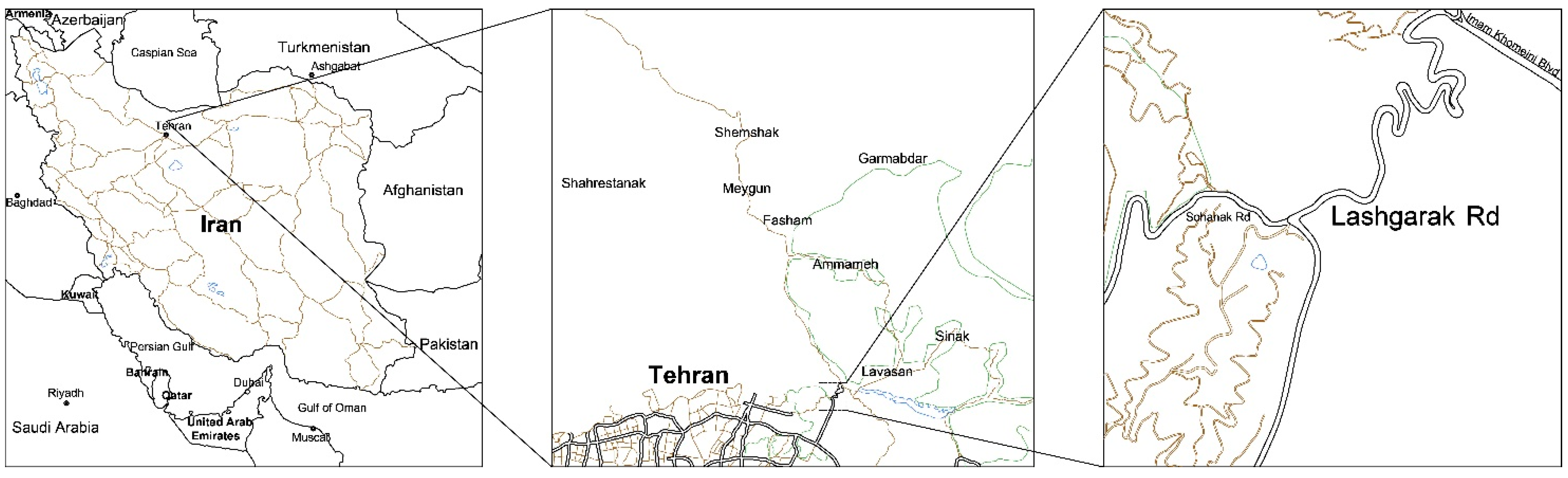
Tehran–Dizin road, a 60-km mountainous road, is located in the heights of central Alborz. The road begins from the Lashgarak–Lavasan road, the study area, and passes residential and recreational areas, reaching Dizin defile at the end (Figure 1). The Jajrud River and Alborz Mountains are considered two major natural attractions along this winding road.
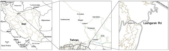
Figure 1.
Road location in three scales, Iran, Tehran, Lashgarak Road.
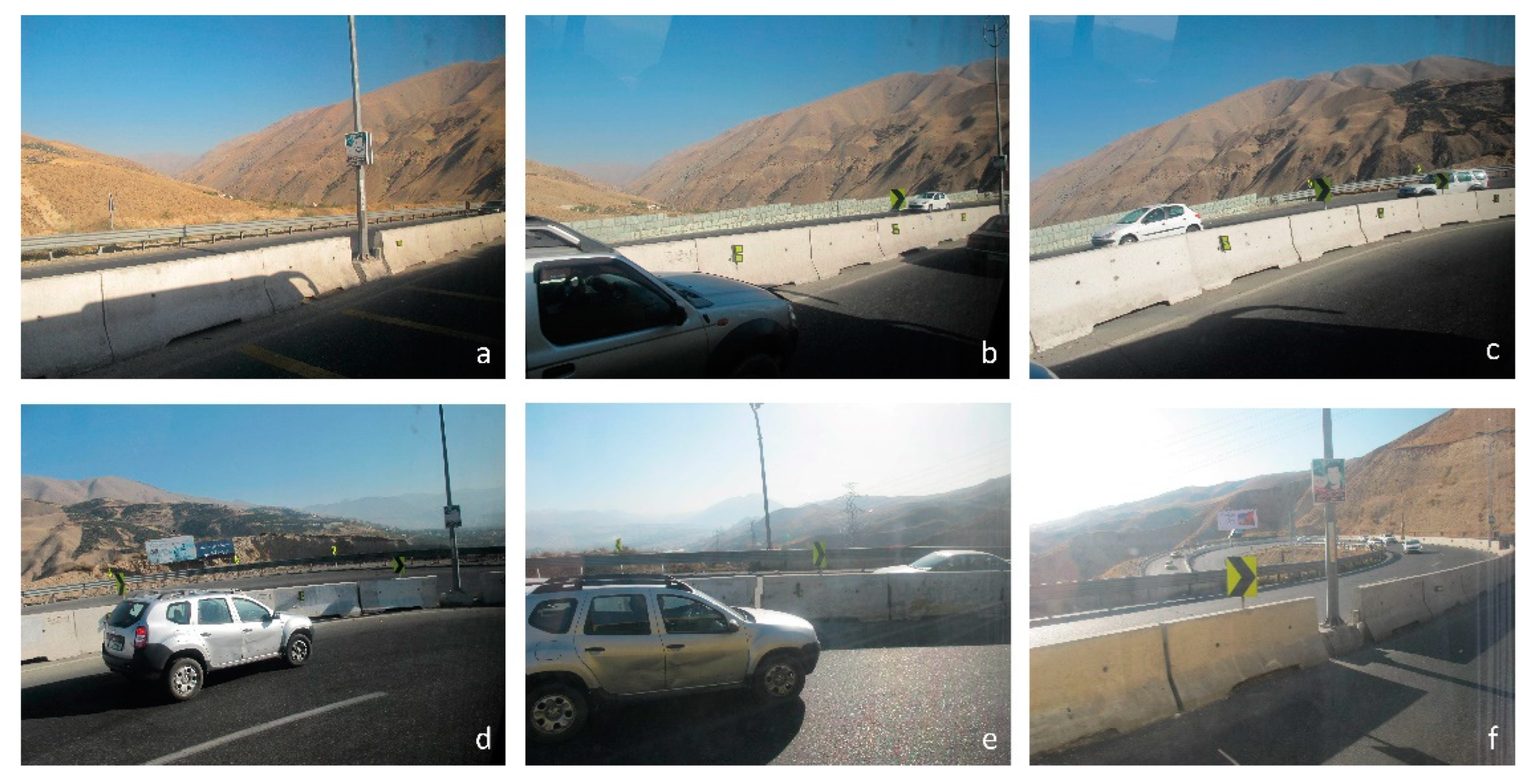
The area which has been surveyed is located in the very first 11 km of Tehran–Dizin road. Having passed 10 successive bends (Figure 2), users would descend from 1850 m high to 1690. The dangerous bend is at 1806 m high, which is 60 m higher than the lowest part. What can be observed in this spot are panoramic views of mountains from northwest to southeast, as well as residential areas (Figure 3).
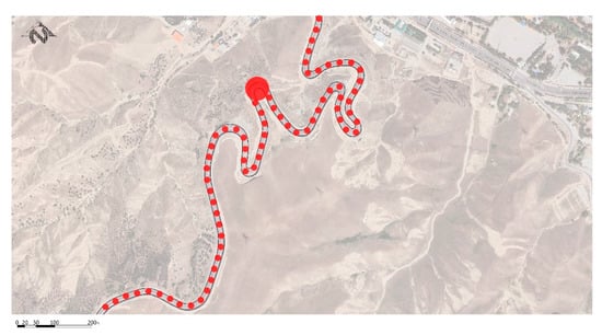
Figure 2.
Successive bends and location of the study area.

Figure 3.
Drivers’ view and bend sequences in six different frames: (a) first view, (b) second view, (c) third view, (d) forth view, (e) fift view, (f) sixth view.
3.2. Methodology Analysis
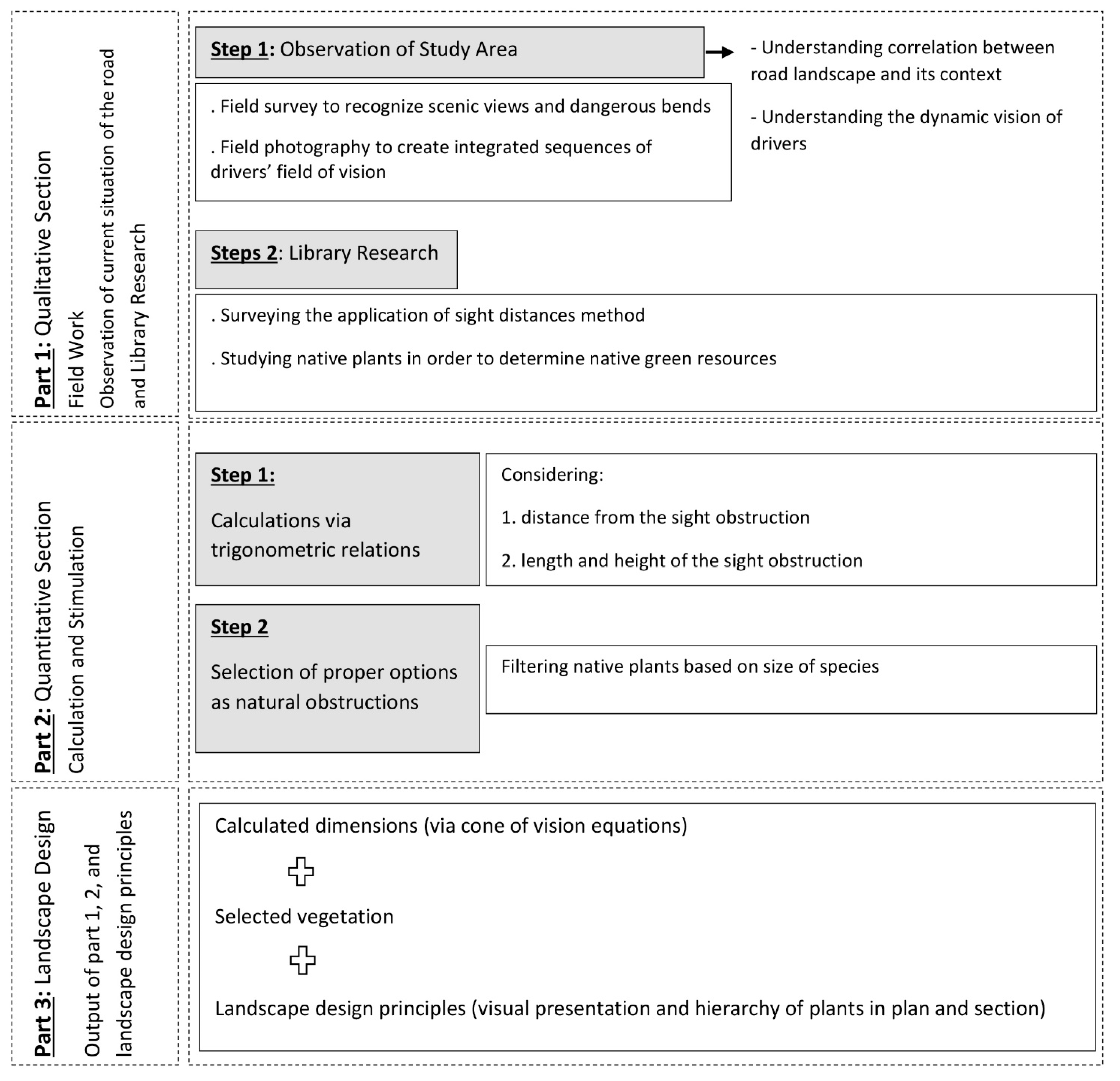
Based on the flowchart (Figure 4), the adopted steps in this research are as follows: in the first step, a field survey and observations were conducted so that researchers became acquainted with the context of the study area, scenic views, and the field of vision of road users. Afterwards, library research was carried out to form a comprehensive literature review on the topic and methods used in the calculation of sight distance and road object dimensions. Having studied the current method and based on a knowledge gap in this field, researchers suggested cone of vision formulas to determine the size of sight obstruction. To maintain sustainability in landscape design, a palette of native plants was selected, which are finally presented in a plan and section.
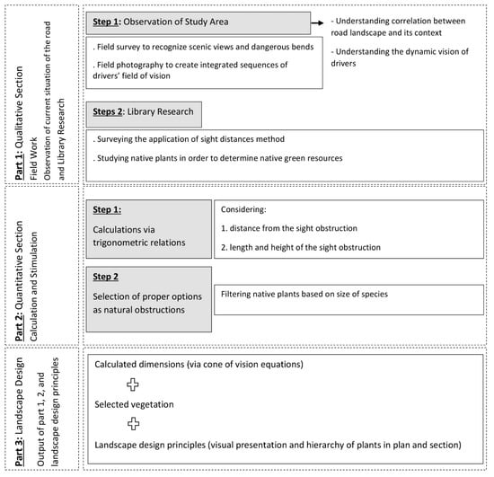
Figure 4.
Flowchart.
3.2.1. Sight Triangle
As a conventional method, the use of sight triangles can be witnessed in past experiments. Among first practices, intersection sight distance design is presented in The American Association of State Highway and Transportation Officials (AASHTO) Green Book, which considers “intersection sight distance to be adequate when drivers at or approaching an intersection have an unobstructed view of the entire intersection and of sufficient lengths of the intersecting highways to permit the drivers to anticipate and avoid potential collisions” [51]. The sight triangle method has further been suggested to avoid accidents, particularly at junctions where vehicles are moving in intersecting roads. For instance, sight triangle equations and calculations were introduced in a retrofit setting in order to address safety and operational concerns and to design facilities and site plans, which will reduce the risk of drivers and cyclists [52]. This notion is a non-barrier surface, which is formed by each road extension along the drivers’ line of sight. In this right triangle, the hypotenuse is drawn from one vehicle to the other one, both of which are moving toward the junction. Two other sides of the triangle would be along the main and secondary roads, crossing each other at the junction [53].
As shown in Figure 5, the sight triangle is a two-dimensional method. This horizontal restriction is cited in past research as a deficiency that needs to incorporate vertical factors [54]. Additionally, this method does not allow road users to recognize forms, texts, and colors used in road elements. To counteract the issue, an approach is defined, applying cone of vision equations to design areas in which one can see stopped or moving vehicles and natural and built elements.
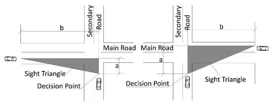
Figure 5.
Sight triangle in a junction; (a) the vertical distances (y- and x-axes) of decision points of two drivers moving toward a junction, (b) the horizontal distances (y- and x-axes) of decision points of two drivers moving toward a junction.
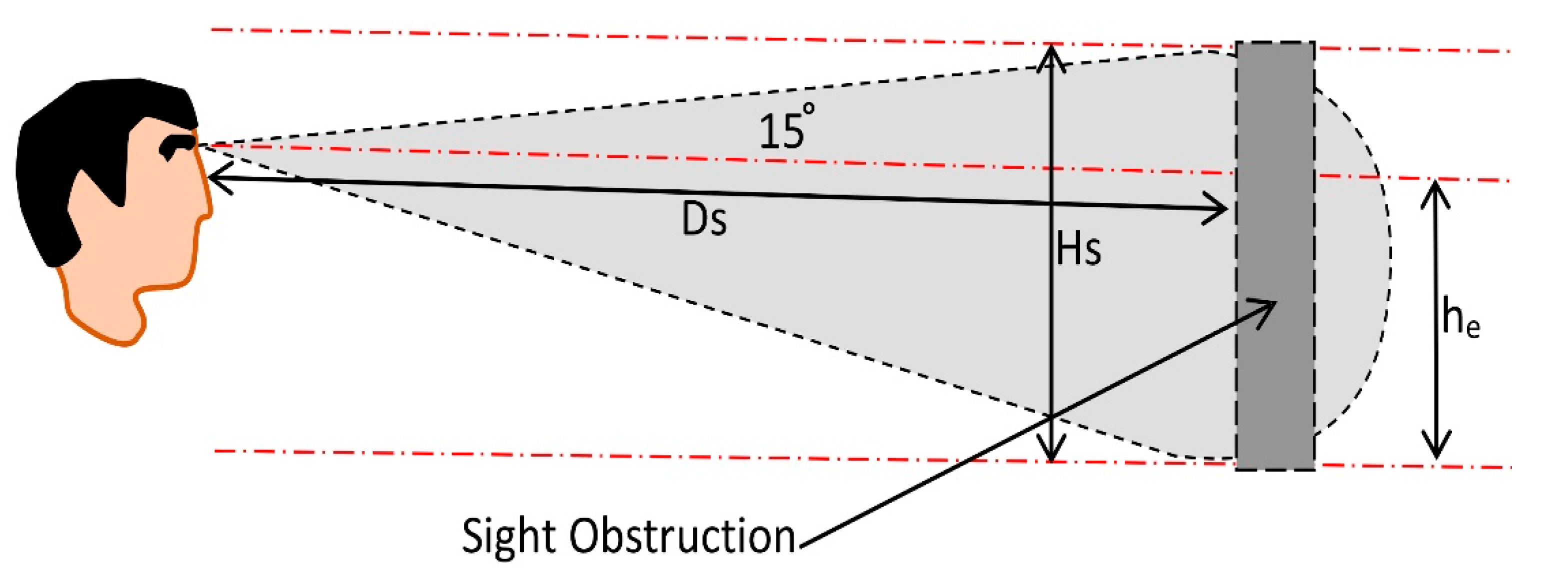
3.2.2. Cone of Vision in Road Landscape
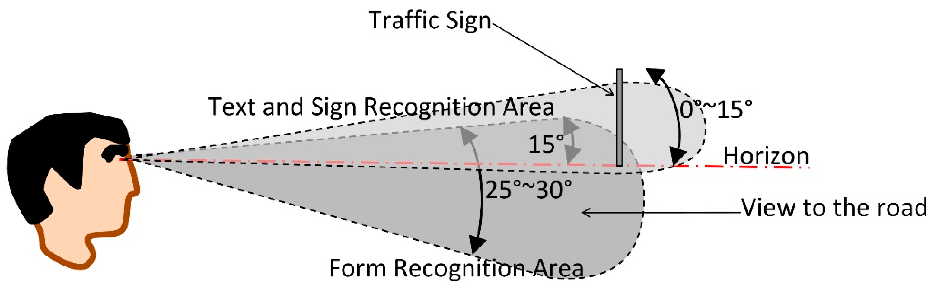
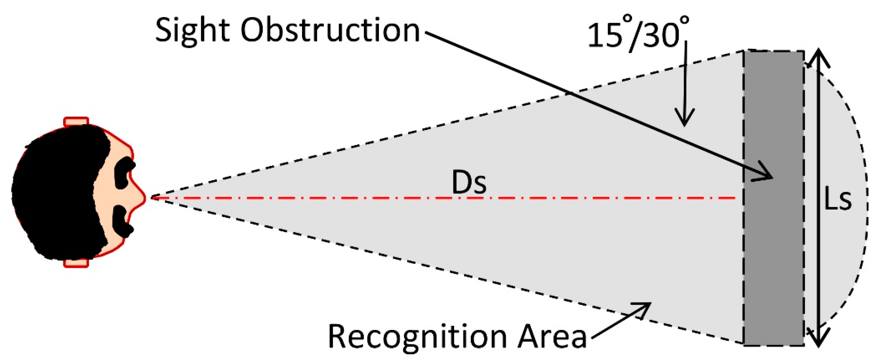
Cone of vision is a hypothetical cone whose apex implies a driver, and its base marks the movement direction (Figure 6 and Figure 7). Via this cone, in addition to height, three different zones could be established: color, form, and text zones (Appendix A). In this practice, the third dimension is included, by which the distance and dimension of roadside components can be defined in order to emphasize or block them from the drivers’ visibility [55].
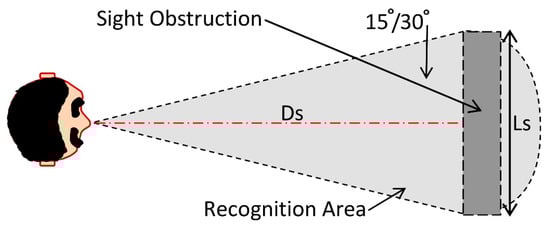
Figure 6.
Driver, recognition area, and sight obstruction presentation in plan.

Figure 7.
Driver, recognition area, and sight obstruction presentation in sections.
In some dangerous areas such as defiles and bends, should a driver be attracted to natural phenomena in surrounding landscapes, it would end up with distractions and accidents. In these situations, it is advisable to restrict drivers’ visibility using built or natural barriers, depending on the budget and other terms and conditions of the project. There are two separate ways to define barrier dimensions:
- Drawing on a map;
- Calculating via trigonometric relations.
In this paper, the second method is used:
- Sight obstruction dimensions:
Ls: length of sight obstruction (m) [55]
Ds: distance from obstruction or other objects (signs, vegetation, etc.) (m)
- 2.
- Sight obstruction height, according to [55], is as follows:
Hs: height of the obstruction
he: approximate eye height from the ground
Ds: distance from obstruction or other objects (signs, vegetation, etc.) (m)
4. Results
4.1. Calculations and Simulations
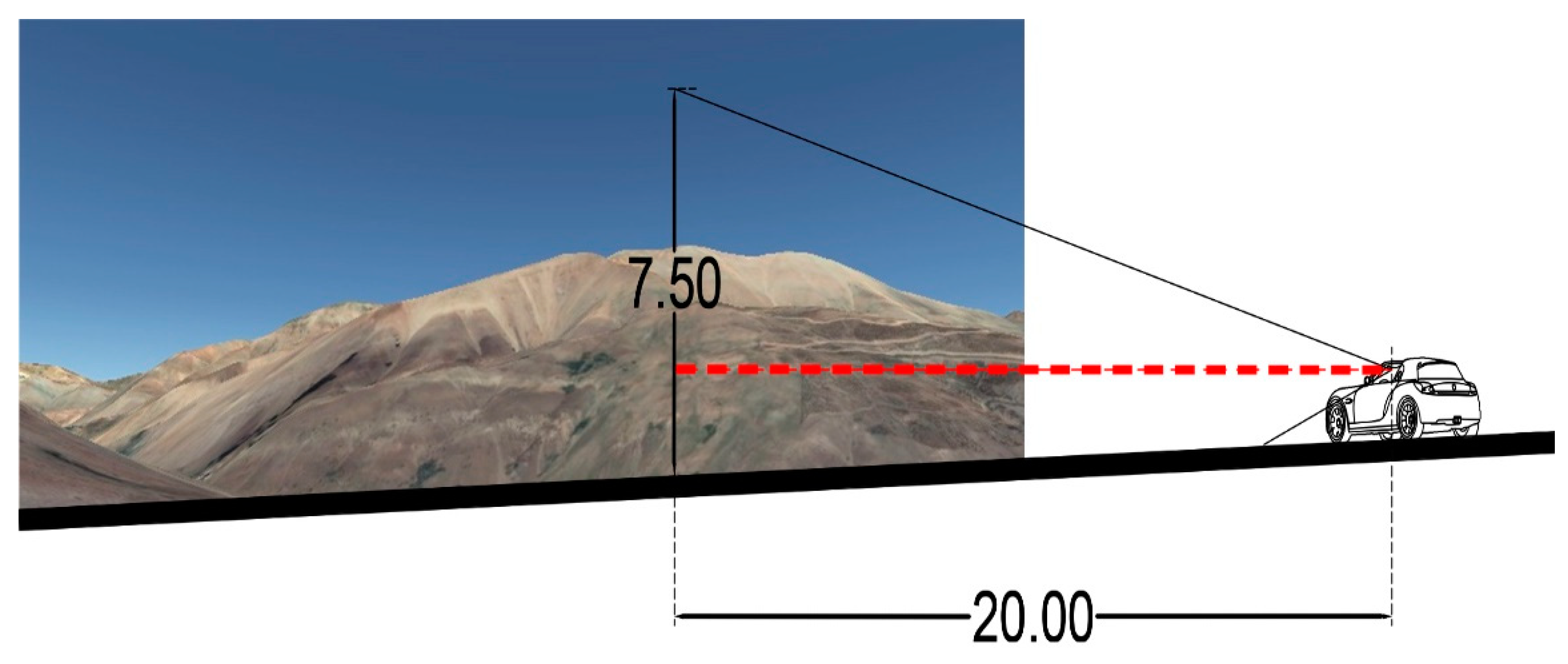
Based on what was mentioned in Section 3.2.2, the calculations would be as follows. With a 20-m distance from the starting point of the bend:
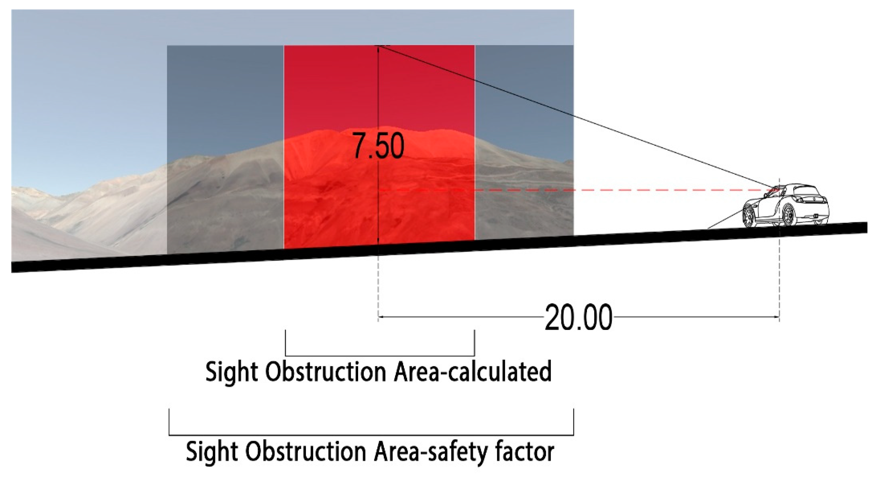
It is important to point out that the calculated dimension is the minimum, and it can be increased based on project demands and budget. Even though a barrier with 10 m length will cover the main distraction in this study, sight obstruction has been lengthened to the recognition area extent (Figure 8).
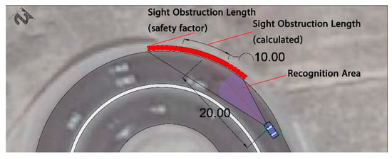
Figure 8.
Calculation of sight obstruction length with and without safety factor.
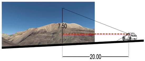
Figure 9.
Simulation of sight obstruction height.
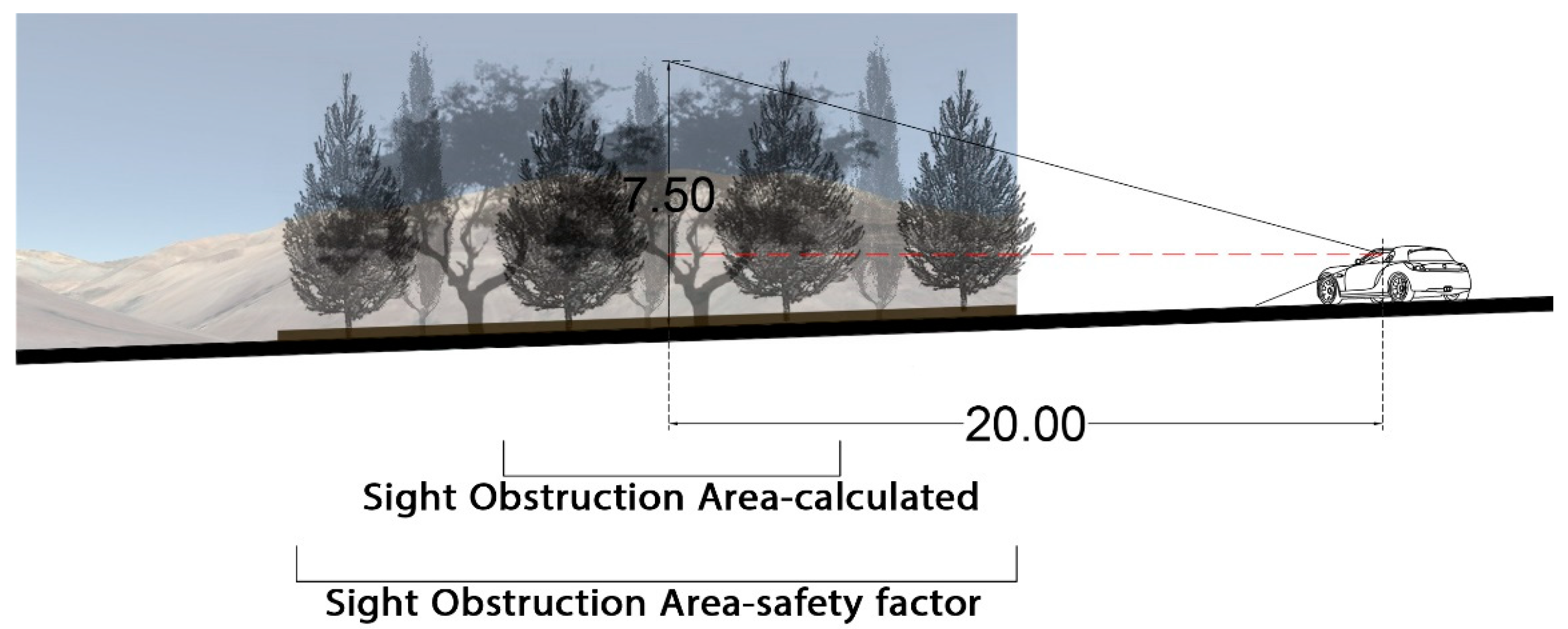
Once dimensions have been calculated, designers choose materials ranging from reinforced concrete to vegetation. The most important aspect they should keep in mind is that constructing a wall (20 × 7.5) out of hard materials (Figure 10) could adversely affect road users’ visibility. In order to ameliorate the effect of a wall’s solid face, a façade could be designed, which can become a distraction itself. From another perspective, road slope, probable landslides, and extreme winds may lead to wall instability. As a restrictive factor, the budget needed for constructing and maintaining a wall would be another setback. As a sustainable solution and so as not to face those predicaments, green resources should perhaps be a substitution (Figure 11).
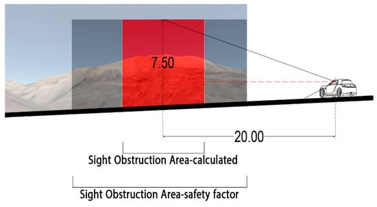
Figure 10.
Simulation of the exact area of obstruction.

Figure 11.
Simulation of vegetation as a sight obstruction with a focus on the 20 × 7.5 area.
Considering vegetation as a barrier would exert benefits, some of which are (Figure 12a,b):
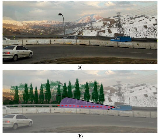
Figure 12.
(a) Dangerous bend with distracting views, (b) sight obstruction simulation.
- A reduction in costs;
- Slope stability owing to roots mesh;
- Doubled safety (guardrail + vegetation).
4.2. Green Resources
Regarding green resources, designers not only pay attention to the main role (sight obstruction) but also consider plants characteristics which make a landscape design “sustainable”. Moreover, a plant community is suggested, especially in roadsides, to alleviate monotony. For instance, trees, shrubs, creepers, cover crops, perennials, grasses, and annual plants are different alternatives [56]. Using a palette of various species with different colors and sizes can positively impact users’ minds [57].
To decide on a sight obstruction in terms of dimensions and material, only the wooded layer has been defined, based on four criteria:
- Appropriateness;
- Level of coverage;
- Wind resistance;
- Soil stabilization.
4.2.1. Floristic Region: Irano-Turanian
This area is located within the Tethyan Subkingdom of the Holarctic Kingdom, which covers approximately three-fourths of Iran. A distinctive characteristic of this region is low precipitation and long arid seasons. The Irano-Turanian zone is famed for its mountains, plains, plateaus, and abundance of plant species in a wide range of diversity. According to botanists, just below 70% of Iranian plant species can be found in this area [58,59].
The region includes different sections, and the case study belongs to “semi-arid, semi-humid forests”, which encompasses the southern domains of the Alborz Mountains and the northwest to southeast of Zagros heights.
4.2.2. Species
Selecting species were based on Irano-Turanian species, Road Landscape Regulations-Guideline: Road Landscape Vegetation, and the four criteria defined above. Firstly, native species which sustain climatic conditions and integrate with the surrounding landscape should be chosen. A number of non-native species are annually being used in agriculture, horticulture, the pharmaceutical industry, and also as ornamental plants in Iran [60]. Since over-dominance of non-native species may result in local extinctions and a decrease in species richness [61], and invaders can change vegetation diversity and ecosystem functions on a large scale [62], selecting native plants is of high importance. As the design occurs in a mountainous area, it is necessary to select plants enduring harsh winds, improving the resistance of the slope, and controlling soil erosion. Having been discussed in Section 2, the abovementioned features need to be included as essential items of a sustainable landscape design. Another influential factor is the density of leaves needed to cover visual distractions. Based on research and visual impact, it is also known that the proportion of evergreens to deciduous trees should be one in two in green patches [63], and it is a major factor in plant selection. By considering the aforementioned factors, Pinus mugo, Fraxinus rotundifolia, and Populus alba have finally been selected.
Populus alba: Being a large tree (maximum 30 m), it grows in steppes where clay soil can be found [64]. Because of strong roots, it can penetrate to lower levels of the ground, so it is effective in soil stability and resistance against winds.
Fraxinus rotundifolia: The tree grows 18 to 24 m in height with an open crown. It is famous for enduring severe conditions, specifically snowy winds in mountainous areas. It is highly recommended on roadsides because of its resistance to air pollution [58]. Vigorous root growth can be a solution to soil erosion and landslide.
Pinus mugo: The conifer is said to grow to 12 m in height. It is witnessed in mild and cold areas with strong winds as it endures harsh windy conditions [65]. On account of its dense texture, it is used as a hedge or sight obstruction [66].
4.2.3. Plant Composition
Preparation, water requirement appraisal, irrigation system, and maintenance measures are dependent on research conducted by natural resources experts and the description of services enacted by the Forests, Range, and Watershed Management Organization in Iran. In view of the whole spectrum of factors that are beyond the capacity of this paper, only plant spacing coming out of form and external shape is considered.
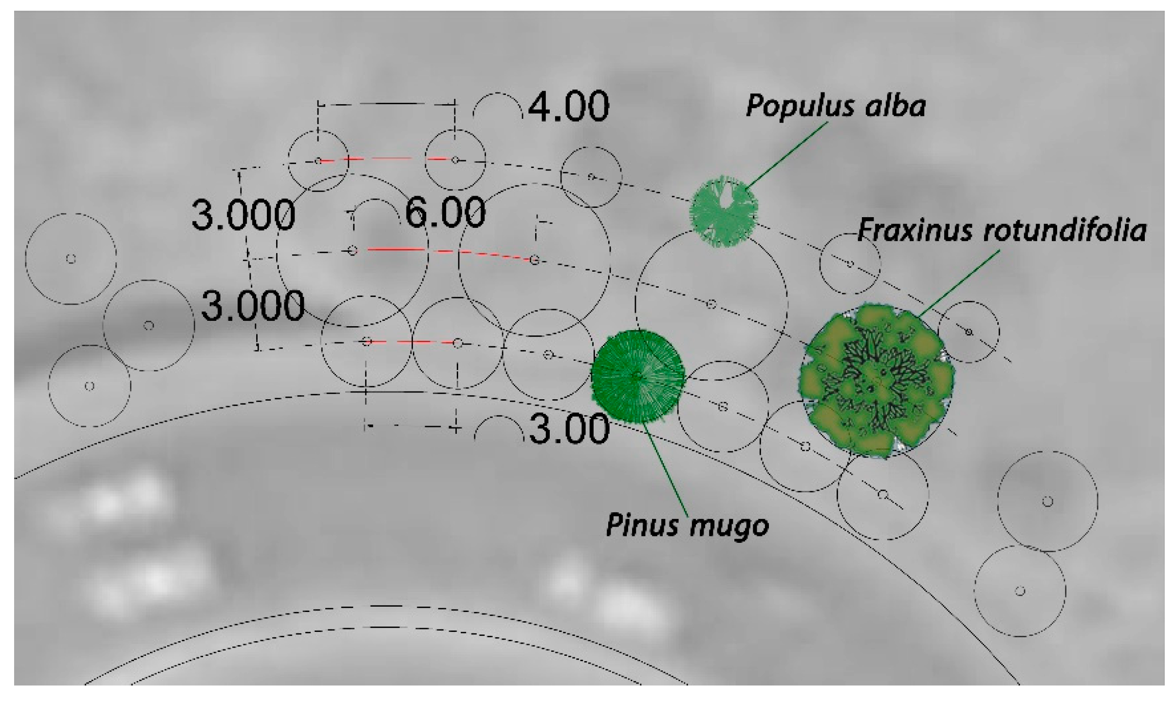
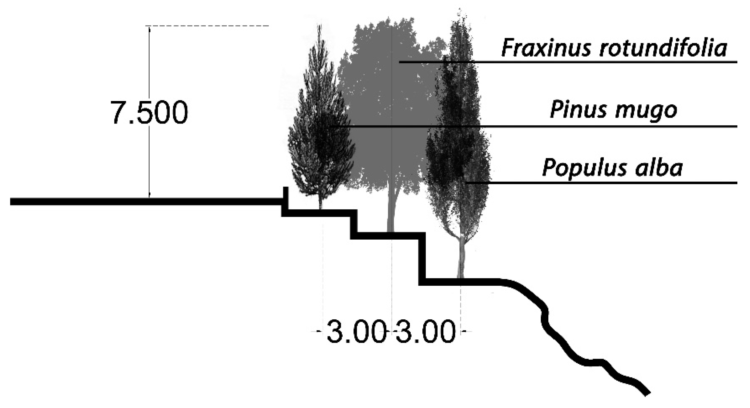
It is worthwhile mentioning that to create a perpetual sight obstruction, coniferous species would be planted in the first row (Figure 13). Being an imperative item, the height of trees can affect the hierarchy of planting [67], as can be seen in Figure 14.

Figure 13.
Plant spacing plan based on species and hierarchy.

Figure 14.
Plant spacing and hierarchy in section.
5. Discussion
Our research depicts that road landscape paves the way for the safe functioning of road infrastructure, improving road environment, creating a sense of place, and integrating the road into the surrounding landscape [68]. Results of this research revealed that landscape design through calculations with a concentration on green resources could potentially boost safety levels by screening disruptive views. It also integrates the road with the character of the surrounding landscape by maintaining the matrix of local vegetation patterns, blending with the local landform and road body.
The main drive of this research can be interpreted by findings of Gue et al. [69], which cite drivers are more likely to pay attention to other moving and stationary targets rather than road conditions in open landscapes such as Lashgarak road’s, leading to considerable vehicle trajectory fluctuations. It is claimed that a landscape that is pleasant, beautiful, harmonious, natural, and has elements that match the surrounding environment, causes more car accidents to occurr, and the more the road landscape is visually safe and sophisticated, fewer car accidents occur [70]. In the Tehran–Dizin road study, researchers sought a method to change a natural, pleasant, and also hazardous landscape into a safe and locally harmonious one by introducing a green barrier. This can be interpreted by Mok et al [71], stating that there is a correlation between landscape treatments and a reduction in accident rates, which illustrates that landscape along the roadside has a positive effect on drivers’ perception and behavior.
Regarding green barriers, results indicate that crown density, root penetration, and height of species are important factors for plant material to meet the safety, economic, and environmental requirements of a landscape design. Based on this, three native species have been chosen, accustomed to local climate and soil conditions so that costs, maintenance, and water consumption are minimized [72], and soil erosion, landslides, and slope instability decrease. The use of native plants can also be beneficial in conserving green resources as it would reestablish the native ecosystem and provide a natural look to roadsides [72]. This is consistent with Lucey and Barton research [31], scrutinizing the evolution of roadside landscape and different approaches towards vegetation management from past eras to to-date strategies. Current strategies for sustainable roadside vegetation embrace an integrated design approach in order to reduce expenditure, minimize maintenance, incorporate regionally appropriate species, and use context-sensitive solutions. These solutions result in the preservation of scenic and environmental resources while maintaining safety along transportation corridors. The paper shows how vegetation serves sustainability by focusing on economic, social, and environmental benefits. Such benefits consist of improved socioeconomic health, cost savings and safety, better water quality, hydraulic conductivity, erosion control, and increased biodiversity [31].
In road landscape studies, different methods consisting of correlation and regression analysis [70], descriptive analysis, statistical tests [68], documentary research, questionnaire survey, Semantic Differential (SD) method—a psychological testing method, using a verbal scale to find out psychological feeling [73], VTI Driving Simulator III [74], driving simulator and digital model [75], fixed-driving simulator using on-site photos, Google maps street view and a topographical map of the road [76], a photo-based method of assessing visual landscape quality [77], pilot studies [78], and library survey analysis were employed. In this research, the before-and-after landscape design simulation (Figure 12a,b) equips designers with a method to examine the hypothesis that the reliance of road landscape design on cone of vision and trigonometric calculations could positively affect crash rates and the environment. It is recommended that in further research, crash data associated with the landscape of road bends along Lashgarak road would be investigated via bilateral cooperation between landscape architects and traffic safety engineers to identify visual distractions that resulted in serious injuries.
Road landscape planning and management could create unity among various small-scale landscape designs in different spots along the road, benefiting both local and regional scales. In this way, a macro-scale approach shall be suggested, acting as an umbrella under which concepts of road landscape design are subsumed. Tehran–Dizin road includes a number of dangerous bends whose landscape characteristics vary. In this case, a holistic management plan is required to assess landscape features, the level of visibility, and safety in different spots in order to develop comprehensive strategies which would lead to integrated design concepts.
6. Conclusions
This paper recommends a trigonometric-based approach for calculating measures of road landscape elements in order to improve safety. Here, green resources were selected as the main landscape element based on both the suggested method and sustainable landscape design features. The key findings of the study are: (1) The cone of vision could practically be a solution to situations where third dimension plays a key role in addressing safety issues, and applying two-dimensional practices is not adequate. This method can be used to manage drivers’ field of view in terms of what should or should not be seen in each view frame. The study emphasizes the importance of mathematical calculations, which should be integrated with the 2D and 3D modeling of a landscape design. Solving not only safety-related matters but aesthetic problems, such a technique could affect people’s behavior and perception in terms of roadside beauty, which could be a future topic of research. (2) The green resources can play a fundamental role in upgrading road safety and sustainability of road landscape if they are selected based on road conditions and specific context. ‘Planted, non-native species’ which can be invasive, have been used for different purposes in landscapes of Iran during recent years. Opting for native species could be a far better substitution as it can (a) help drivers to feel attached to their driving space as those plants integrate with surrounding green areas, (b) enhance the richness of green resources, and (c) contribute to sustainable landscapes on a broad scale.
Author Contributions
Conceptualization M.H., E.C. and A.M.; methodology M.H., E.C. and A.M.; investigation M.H., E.C. and A.M.; formal analysis M.H., E.C. and A.M.; writing M.H., E.C. and A.M. All authors have read and agreed to the published version of the manuscript.
Funding
This research received no external funding.
Institutional Review Board Statement
Not applicable.
Informed Consent Statement
Not applicable.
Data Availability Statement
Not applicable.
Conflicts of Interest
The authors declare no conflict of interest.
Abbreviations
| PIARC | Permanent International Association of Road Congresses |
| HEV | Human–Environment–Vehicle |
| AASHTO | American Association of State Highway and Transportation Officials |
| SD | Semantic Differential |
Appendix A
Calculating the approximate location of a road sign would be based on distance from the sign, its dimensions, and angle of the cone of vision, as follows:
- Calculation of Distance, according to [55], is as follows:
W: width of the sign (m)
Ds: distance from the sign (m)
- 2
- Calculation of the sign height according to [55], is as follows:
h: height of the sign (m)
Ds: distance from the sign (m)

Figure A1.
Cone of vision and signs in vertical section.
Figure A1.
Cone of vision and signs in vertical section.
Minimum distance from text, sign, and color change on the ground would be calculated based on [55]:
D: minimum distance (m)
He: eye height from the ground (m) [approximately 1.5m]
α: angle of the cone of vision with the horizon (50°, 25°, and 15° for color change, sign, and text respectively)
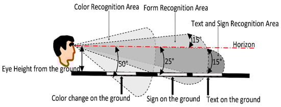
Figure A2.
Cone of vision and signs on the ground.
Figure A2.
Cone of vision and signs on the ground.
References
- World Health Organization. Save LIVES-A Road Safety Technical Package; World Health Organization: Geneva, Swityerland, 2017. [Google Scholar]
- Taravatmanesh, L.S.M.; Mortazavi, M.R.; Baneshi, M.; Shirbeygi, P.; Saeedifar, A.; Zolala, F. Epidemiology of road traffic accidents in Rafsanjan city, Iran. Electron. Phys. 2018, 10, 5. [Google Scholar]
- Bucsuházy, K.; Matuchová, E.; Zůvala, R.; Moravcová, P.; Kostíková, M.; Mikulec, R. Human factors contributing to the road traffic accident occurrence. Transp. Res. Procedia 2020, 45, 555–561. [Google Scholar] [CrossRef]
- Permanent International Association of Road Congresses. Road Safety Manual; Route2 Market: Dartford, UK, 2003. [Google Scholar]
- Treat, J.; Tumbas, J.N.; McDonald, S.; Shinar, D.; Hume, R.; Mayer, R.; Stansifer, R.; Castellan, N. Tri-Level Study of the Causes of Traffic Accidents: Final Report. Executive Summary; Institute for Research in Public Safety, Indiana University: Bloomington, IN, USA, 1979. [Google Scholar]
- Egebjerg, U.; Friis, P.; Lützen, N.; Tørsløv, N.; Wandall, B. Beautiful Roads: A Handbook of Road Architecture; Danish Road Directorate: Copenhagen, Denmark, 2002. [Google Scholar]
- Drottenborg, H. Are Beautiful Traffic Environments Safer than Ugly Traffic Environments? LTH, Department for Technology and Society, Lund University: Lund, Sweden, 2002; Volume 11. [Google Scholar]
- Sétra. Landscape and Road Legibility: Some Ideas for an Approach That Brings Together Road Safety and Landscape; Sétra, Service D’etudes Techniques des Routes et Autoroutes: Vénissieux, France, 2006. [Google Scholar]
- Gibson, J.J.; Crooks, L.E. A Theoretical Field-Analysis of Automobile-Driving. Am. J. Psychol. 1938, 51, 453. [Google Scholar] [CrossRef]
- Sétra. Sécurité des Routes et des Rues; Sétra: Vénissieux, France, 1992. [Google Scholar]
- Echaniz, I.E. Roads in the Landscape: Criteria for Their Planning, Layout and Project Design; Junta De Andalucia, Consejería Obras Públicas y Transportes: Sevilla, Spain, 2009. [Google Scholar]
- Bell, S. Design for Outdoor Recreation; Taylor & Francis: London, UK, 1997. [Google Scholar]
- Dharmasena, S.; Edirisooriya, S. Impact of Roadside Landscape to Driving Behaviour; Lessons from Southern Highway, Sri Lanka. Cities People Places Int. J. Urban Environ. 2018, 3, 66–86. [Google Scholar] [CrossRef]
- Jia, Z.R. Highway Roadside and Median Green Belts Design Method Based on the Theory of Dynamic Vision. Appl. Mech. Mater. 2012, 178–181, 1417–1421. [Google Scholar] [CrossRef]
- Department of Transport and Main Roads. Chapter 5-Safety. In Road Landscape Manual; State of Queensland, Department of Transport and Main Roads: Brisbane, Australia, 2013; p. 41. [Google Scholar]
- Heerwagen, J.; Schauman, S.; Moudon, A.; Witherspoon, V.; James, S.; Mundee, J. Visual Perception of the Roadway and Roadside Elements by the Observer in Motion, Washington State Transportation Center (TRAC); University of Washington, Department of Landscape Architecture: Washington, DC, USA, 1992. [Google Scholar]
- Heikkinen, T. Interactive visualisation of the cone of vision as a design tool. In Proceedings of the International Design Conference, Dubrovnik-Croatia, 19–22 May 2008. [Google Scholar]
- Jiang, B.; He, J.; Chen, J.; Larsen, L. Moderate is optimal: A simulated driving experiment reveals freeway landscape matters for driving performance. Urban For. Urban Green. 2021, 58, 126976. [Google Scholar] [CrossRef]
- Jiang, B.; He, J.; Chen, J.; Larsen, L.; Wang, H. Perceived Green at Speed: A Simulated Driving Experiment Raises New Questions for Attention Restoration Theory and Stress Reduction Theory. Environ. Behav. 2021, 53, 296–335. [Google Scholar] [CrossRef]
- Zheng, H.; Qin, Y.; Guo, F.; Xiong, J.; Xu, B.; Chen, Y. Speed and reaction behavior in different highway landscapes: A driving simulator study. Traffic Inj. Prev. 2018, 19, 880–884. [Google Scholar] [CrossRef] [PubMed]
- Antonson, H.; Ahlstrom, C.; Wiklund, M.; Blomqvist, G.; Mårdh, S. Crash Barriers and Driver Behavior: A Simulator Study. Traffic Inj. Prev. 2013, 14, 874–880. [Google Scholar] [CrossRef]
- Antonson, H.; Mårdh, S.; Wiklund, M.; Blomqvist, G. Effect of surrounding landscape on driving behaviour: A driving simulator study. J. Environ. Psychol. 2009, 29, 493–502. [Google Scholar] [CrossRef]
- Calvi, A. Does Roadside Vegetation Affect Driving Performance? Driving Simulator Study on the Effects of Trees on Drivers’ Speed and Lateral Position. Transp. Res. Rec. J. Transp. Res. Board 2015, 2518, 1–8. [Google Scholar] [CrossRef]
- Fumagalli, N.; Maccarini, M.; Rovelli, R.; Berto, R.; Senes, G. An Exploratory Study of Users’ Preference for Different Planting Combinations along Rural Greenways. Sustainability 2020, 12, 2120. [Google Scholar] [CrossRef] [Green Version]
- Fitzpatrick, C.D.; Harrington, C.P.; Knodler, M.A., Jr.; Romoser, M.R.E. The influence of clear zone size and roadside vegetation on driver behavior. J. Saf. Res. 2014, 49, e1-104. [Google Scholar] [CrossRef]
- Main Roads Western Australia. Visual Screens within the Road Reserve. In Role Description, Executive Director Planning and Technical Services; Planning, Industry & Environment: Parramatta, Australia, 2013. [Google Scholar]
- Wolf, K.L. Freeway roadside management: The urban forest beyond the white line. J. Arboric. 2003, 29, 127–136. [Google Scholar]
- Kaplan, R.; Kaplan, S. The Experience of Nature: A Psychological Perspective; CUP Archive: Cambridge, UK, 1989. [Google Scholar]
- Kaplan, S.; Kaplan, R.; Wendt, J.S. Rated preference and complexity for natural and urban visual material. Percept. Psychophys. 1972, 12, 354–356. [Google Scholar] [CrossRef]
- Kocur-Bera, K.; Dudzinska, M. Roadside Vegetation–The Impact on Safety. In Proceedings of the International Scientific Conference Engineering for Rural Development, Jelgava, Latvia, 20–22 May 2015. [Google Scholar]
- Lucey, A.; Barton, S. Public Perception and Sustainable Management Strategies for Roadside Vegetation. Transp. Res. Rec. J. Transp. Res. Board 2011, 2262, 164–170. [Google Scholar] [CrossRef]
- Littlewood, M. The Management of Roadside Plantings. Arboric. J. 1988, 12, 145–162. [Google Scholar] [CrossRef]
- Milton, S.J.; Dean, W.R.J.; Sielecki, L.E.; van der Ree, R. The Function and Management of Roadside Vegetation. In Handbook of Road Ecology; John and Wiley and Sons: Hoboken, NJ, USA, 2015; pp. 373–381. [Google Scholar]
- Bassuk, N.; Trowbridge, P. Creating the Urban Eden: Sustainable Landscape Establishment in Theory and Practice. HortTechnology 2010, 20, 485–486. [Google Scholar] [CrossRef] [Green Version]
- Rosen, M. Creating Sustainable Communities; Office of Planning and Sustainable Communities: New York, NY, USA, 2007. [Google Scholar]
- Hitchmough, J. Exotic plants and plantings in the sustainable, designed urban landscape. Landsc. Urban Plan. 2011, 100, 380–382. [Google Scholar] [CrossRef]
- EPA. Memorandum on Environmentally Beneficial Landscaping; Environmental Protection Agency, United States Federal Government: Washington, DC, USA, 1994.
- Thomas, G.S.; Sim, J.C.; Poulton, D.V. Planting Design: An Exploration of Emerging Theoretical Frameworks to Support Sustainable Landscape Design; Queensland University of Technology: Brisbane, Australia, 2001. [Google Scholar]
- Yu, F.F.; Yang, Y.A.; Li, H.; Xiang, F. Sustainable Design on Urban Landscape. Adv. Mater. Res. 2011, 374, 100–104. [Google Scholar] [CrossRef]
- Bean, C.; Yang, C.-H. Standards in Sustainable Landscape Architecture; The University of Texas at Austin, School of Architecture, CSD: Austin, TX, USA, 2009. [Google Scholar]
- Liu, Y.J. A Study on Sustainable Green Ecological Landscape Design. Adv. Mater. Res. 2014, 919, 1641–1644. [Google Scholar] [CrossRef]
- Huang, L.; Zuo, J.; Zhu, L.; Ouadha, A. Study on the Construction of Eco-Control Technique System for Sustainable Landscape Design. In Sustainable Development; World Scientific Pub Co Pte Lt: Singapore, 2016; pp. 517–524. [Google Scholar]
- Wu, Y.X.; Yu, S. Based on the theory of landscape ecology, landscape cost minimization approach. J. Harbin Inst. Technol. 2011, 13, 82–88. [Google Scholar]
- Pirnia, M.K.; Keramat-ollah, A. Rah va Rebat; Ministry of Cultural Heritage, Tourism and Handicrafts: Tehran, Iran, 1991. (In Persian) [Google Scholar]
- Motaghi, A.; Karami, M.; Beigi, M.G. Roads as Lifelines in Ancient World (Case study: Silk Road). Historiography 2014, 60, 1–20. (In Persian) [Google Scholar]
- Shokuhi Bidhendi, M.S.; Amini Kashani, A. Assessment of Tehran-Shomal Freeway Construction Effects on Landscape based on Sustainable Development Criteria. In Proceedings of the 1st Conference on Engineering and Innovation, Tabriz, Iran, 2–3 December 2020. (In Persian). [Google Scholar]
- Aghazadeh, F.; Najafi, K.; Kafi, M. Green Area Design in Tehran-Karaj Freeway Landscape-Developing Environmental and Functional Quality. In Proceedings of the 1st International Conference on Urban and Intercity Roads Landscape (A Vernacular Approach), Tehran, Iran, 1 March 2018. (In Persian). [Google Scholar]
- Vice-Presidency for Strategic Planning and Supervision, Technical System Affairs, Road Safety Manual (Fundamentals of Highway Safety Design)-Rule No.267-1; Management and Planning Organization: Tehran, Iran, 2014. (In Persian)
- Ahadi, M.; Ebrahimi, A.-O.-R. Traffic Safety Development through Roadside Barriers. Traffic Manag. Stud. 2010, 14, 23–42. (In Persian) [Google Scholar]
- Abd-ol-Maleki, F. New Jersey Fence & Guard Rail Investigation, Comparison and the Necessity of Choosing New Jersey Fence as a Better Alternative in Road Safety. Q. J. Appl. Res. Eng. 2021, 2, 1–17. (In Persian) [Google Scholar]
- American Association of State Highway and Transportation Officials. A Policy on Geometric Design of Highways and Streets; American Association of State Highway and Transportation Officials: Washington, DC, USA, 1994. [Google Scholar]
- Mollett, C.J.; William, C.; Repovski, J. Off-Road Cycling Facilities-Sight Triangle Requirements at Stop Controlled Driveway and Side Road Crossings. In Proceedings of the 2020 TAC Conference, Toronto, ON, Canada, 19–21 October 2020. [Google Scholar]
- Vice-Presidency for Strategic Supervision, Technical System Affairs. Highway Geometric Design Code-No.415; Vice-Presidency for Strategic Planning and Supervision: Tehran, Iran, 2012. (In Persian) [Google Scholar]
- Son, Y.-T.; Kim, S.-G.; Lee, J.-K. Methodology to Calculate Sight Distance Available to Drivers at Skewed Intersections. Transp. Res. Rec. J. Transp. Res. Board 2002, 1796, 41–47. [Google Scholar] [CrossRef]
- Fardanesh, F.; Habibi, M. Road Landscape Regulations-Guideline:Visibility, Safety and Road Landscape; Urban Development and Revitalization Organization of Iran: Tehran, Iran, 2018; Volume 2. (In Persian) [Google Scholar]
- Scarfone, S.C. Professional Planting Design: An Architectural and Horticultural Approach For Creating Mixed Bed Plantings; Research Training Center of Tehran University: Tehran, Iran, 2015. (In Persian) [Google Scholar]
- California Department of Transportation. Highway Planting Design, Plans, Plant List and Specifications Sheet. In Landscape Architecture PS & E Guide; California Department of Transportation: Sacramento, CA, USA, 2008. [Google Scholar]
- Habibi, M. Road Landscape Regulations-Guideline: Road Landscape Vegetation; Urban Development and Revitalization Organization of Iran: Tehran, Iran, 2018; Volume 3. (In Persian) [Google Scholar]
- Sabeti, H. Forests, Trees and Shrubs of Iran; Yazd University: Yazd, Iran, 2003. (In Persian) [Google Scholar]
- Madani, S.; Ravanbakhsh, M.; Panahandeh, M. A review of the assessment and management of the ecological risk of invasive plants. J. Environ. Res. Technol. 2017, 2, 25–34, (In Persian with English Abstract). [Google Scholar]
- Pauchard, A.; Shea, K. Integrating the Study of Non-native Plant Invasions across Spatial Scales. Biol. Invasions 2006, 8, 399–413. [Google Scholar] [CrossRef]
- Parker, I.; Simberloff, D.; Lonsdale, W.; Goodell, K.; Wonham, M.; Kareiva, P.; Williamson, M.; Von Holle, B.; Moyle, P.; Byers, J.; et al. Impact: Toward a Framework for Understanding the Ecological Effects of Invaders. Biol. Invasions 1999, 1, 3–19. [Google Scholar] [CrossRef]
- Vice-Presidency for Strategic Supervision, Executive Technical System Affairs. Criteria for Urban Landscape Design-No.203; Vice-Presidency for Strategic Planning and Supervision: Tehran, Iran, 2010. (In Persian) [Google Scholar]
- Kaneshloo, H. Proper Species for Irano-Turani Zone; Research Institute of Forests and Rangelands: Tehran, Iran, 2015; Volume 2. (In Persian) [Google Scholar]
- Mozaffarian, V. Trees and Shrubs of Iran; Contemporary Culture: Tehran, Iran, 2004. (In Persian) [Google Scholar]
- Agha Beigi, F. Growing Trees and Shrubs in Iran; Iran Agriculture: Isfahan, Iran, 1995. (In Persian) [Google Scholar]
- Fardanesh, F.; Adib, M.; Habibi, M.; Chitsazzadeh, E.; Karimi, E. Road Landscape Planning Regulations; Urban Development and Revitalization Organization of Iran: Tehran, Iran, 2018. (In Persian) [Google Scholar]
- Vugule, K. Road Landscape Modelling; Mengots, A., Stokmane, I., Eds.; Latvia University of Life Sciences and Technologies: Jelgava, Latvia, 2018. [Google Scholar]
- Guo, F.; Li, M.; Chen, Y.; Xiong, J.; Lee, J. Effects of Highway Landscapes on Drivers’ Eye Movement Behavior and Emergency Reaction Time: A Driving Simulator Study. J. Adv. Transp. 2019, 2019, 1–9. [Google Scholar] [CrossRef]
- Matijošaitienė, I.; Navickaitė, K. Aesthetics and Safety of Road Landscape: Are they Related? J. Sustain. Archit. Civ. Eng. 2012, 1, 20–25. [Google Scholar] [CrossRef]
- Mok, J.-H.; Landphair, H.C.; Naderi, J.R. Landscape improvement impacts on roadside safety in Texas. Landsc. Urban Plan. 2006, 78, 263–274. [Google Scholar] [CrossRef]
- Chowdhury, M.H.; Lasker, M.S. Roadside landscaping with native plants in the Czech Republic: A review. Hortic. Int. J. 2018, 2, 1. [Google Scholar] [CrossRef]
- Liu, J.-T.; Meng, X.-B. Highway Safety Landscape Design Based on Dynamic Vision. In Proceedings of the CICTP 2012, Beijing, China, 3–6 August 2012. [Google Scholar]
- Antonson, H.; Ahlstrom, C.; Mårdh, S.; Blomqvist, G.; Wiklund, M. Landscape heritage objects’ effect on driving: A combined driving simulator and questionnaire study. Accid. Anal. Prev. 2014, 62, 168–177. [Google Scholar] [CrossRef]
- Pasetto, M.; Barbati, S.D. When the Road Layout Becomes Persuasive for the Road Users: A Functional Study on Safety and Driver Behaviour. Procedia Soc. Behav. Sci. 2012, 48, 3274–3283. [Google Scholar] [CrossRef]
- Liva, A.; Mette, M. The Relationship between Road Design and Driving Behavior: A Simulator Study. In Proceedings of the 3rd International Conference on Road Safety and Simulation, Indianapolis, IN, USA, 14–16 September 2011. [Google Scholar]
- Martín, B.; Arce, R.; Otero, I.; Loro, M. Visual Landscape Quality as Viewed from Motorways in Spain. Sustainability 2018, 10, 2592. [Google Scholar] [CrossRef] [Green Version]
- Naderi, J.R. Landscape Design in Clear Zone: Effect of Landscape Variables on Pedestrian Health and Driver Safety. Transp. Res. Rec. J. Transp. Res. Board 2003, 1851, 119–130. [Google Scholar] [CrossRef] [Green Version]


Publisher’s Note: MDPI stays neutral with regard to jurisdictional claims in published maps and institutional affiliations. |
© 2022 by the authors. Licensee MDPI, Basel, Switzerland. This article is an open access article distributed under the terms and conditions of the Creative Commons Attribution (CC BY) license (https://creativecommons.org/licenses/by/4.0/).