
Proposal of a Quantitative Assessment Method for Viewpoint Geosites


Abstract
1. Introduction
2. Materials and Methods
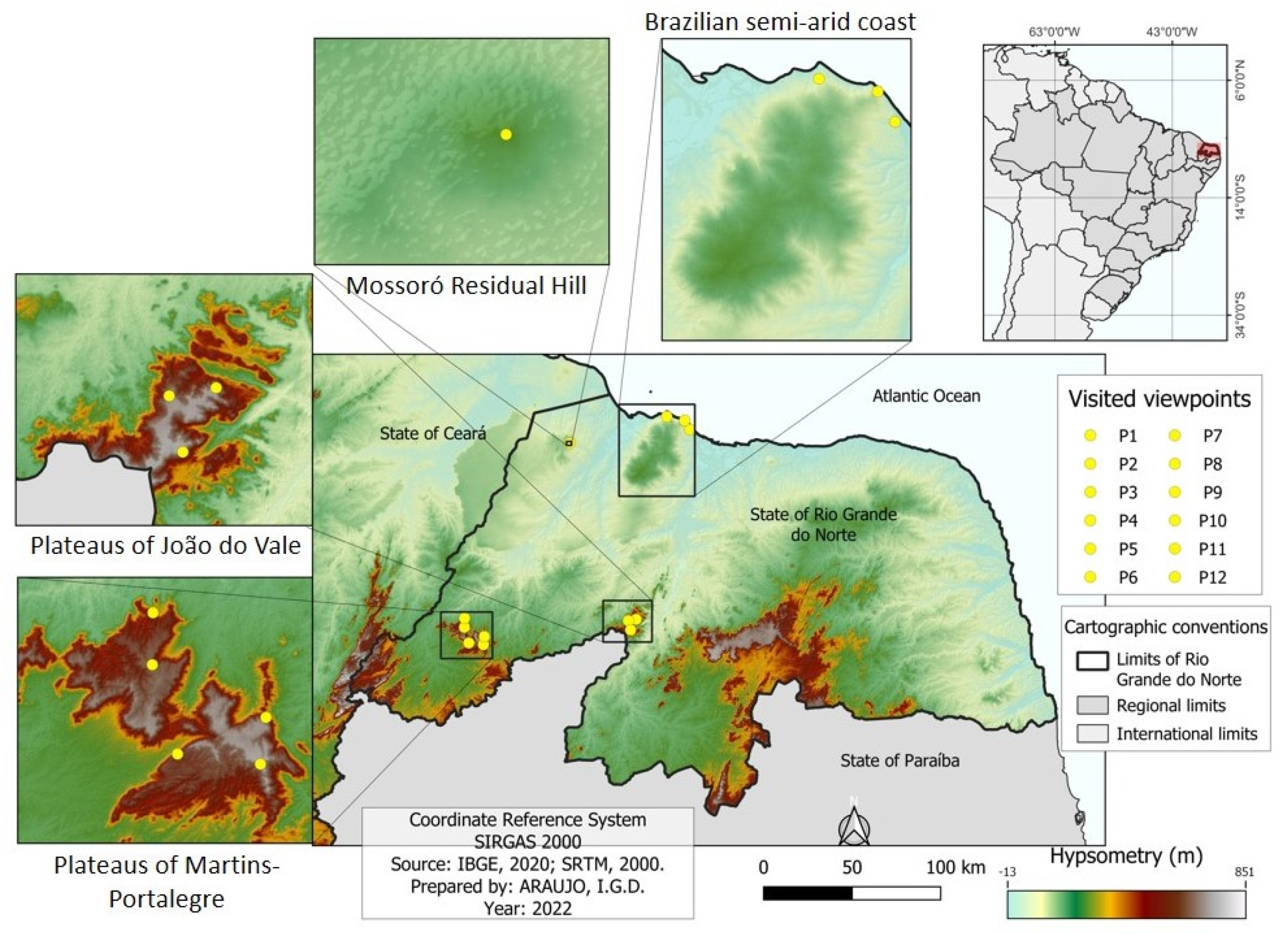
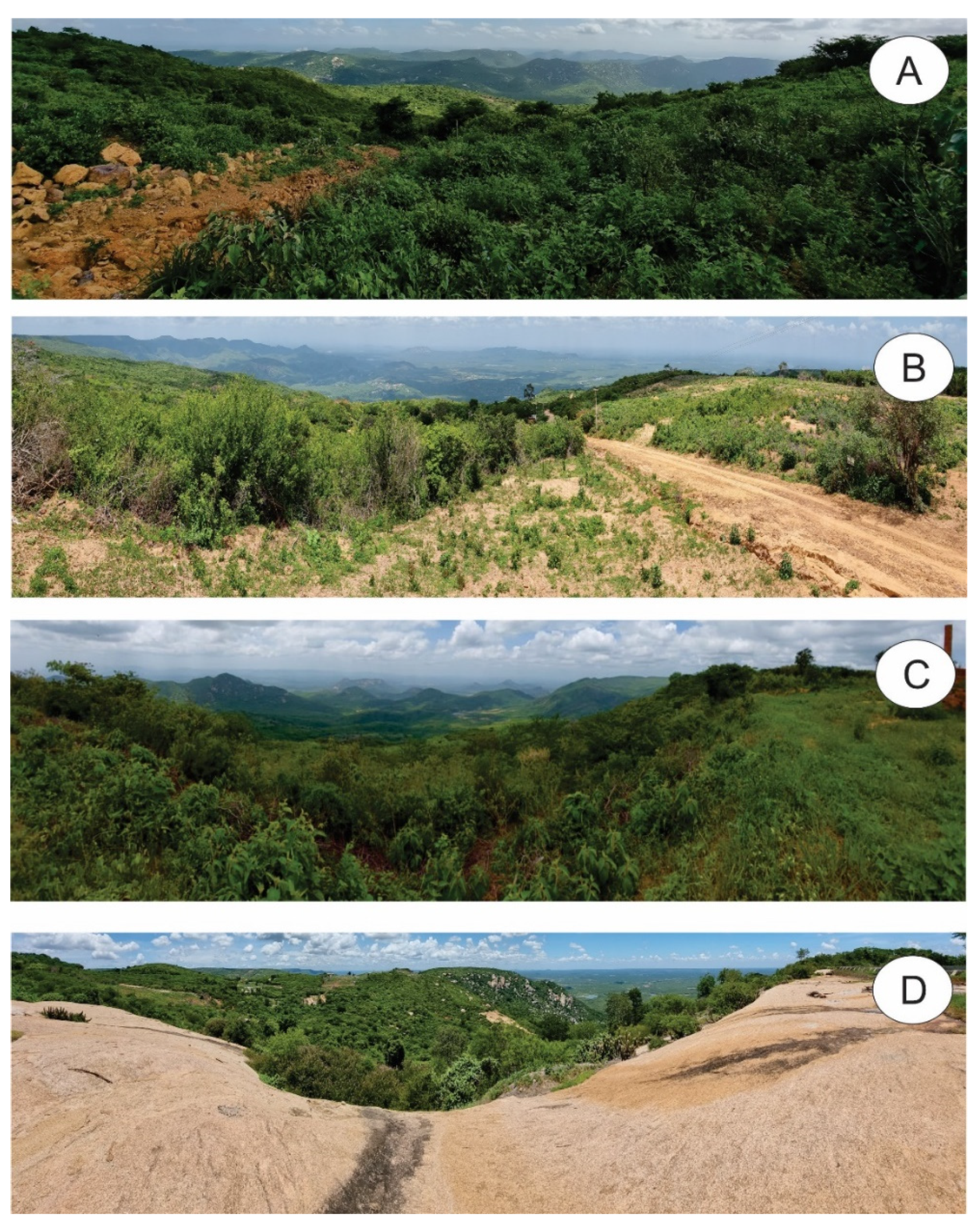
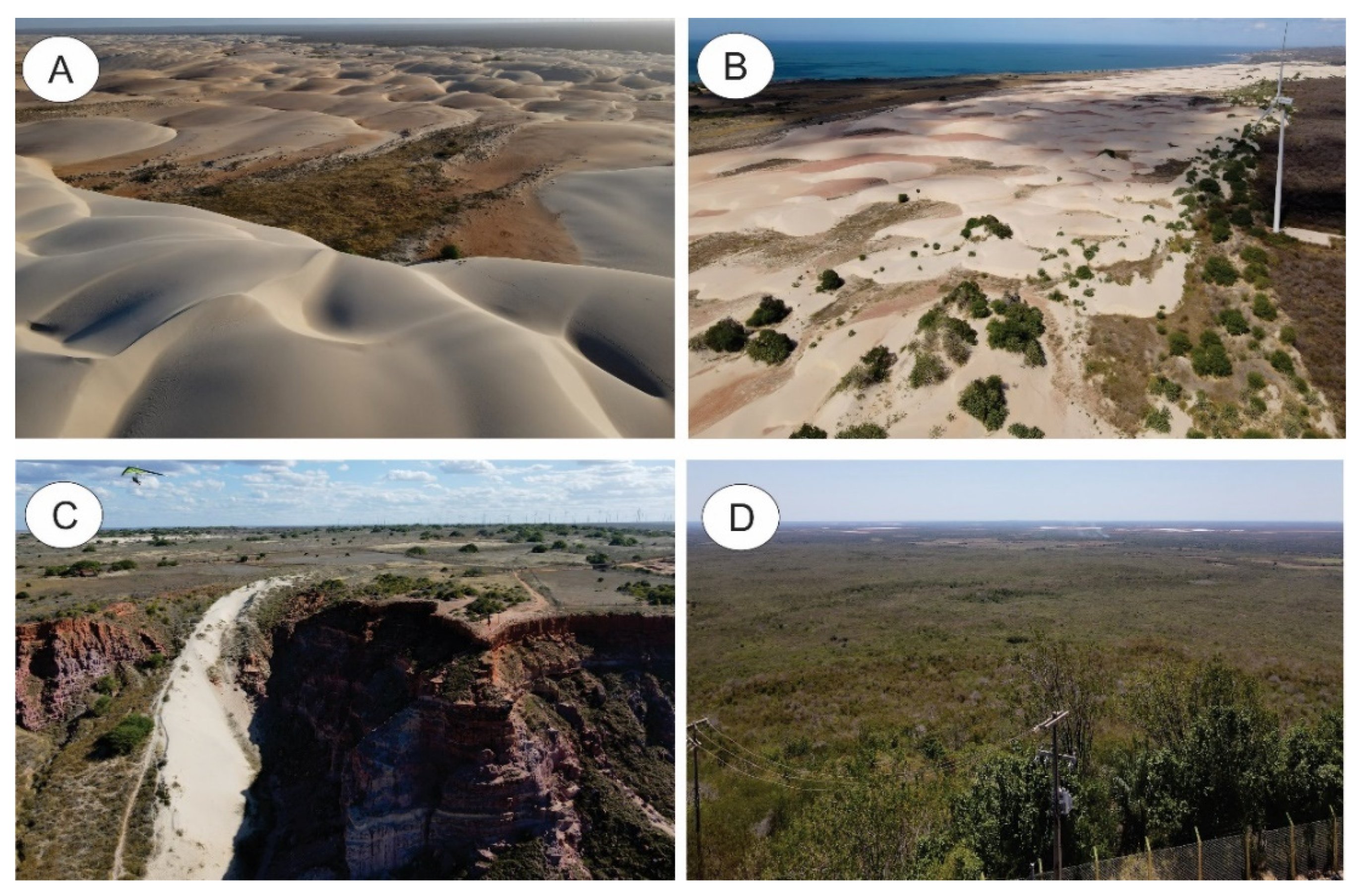
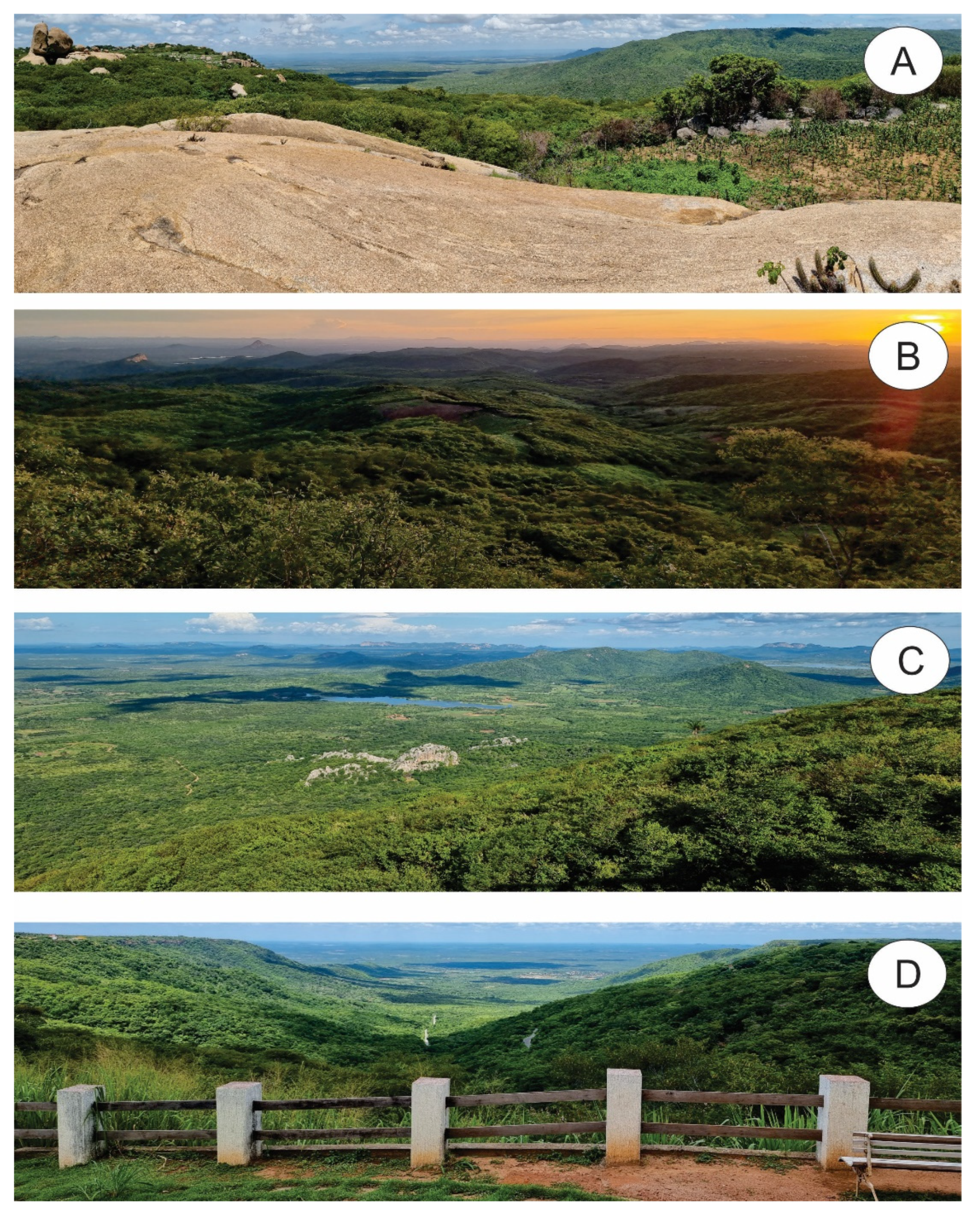
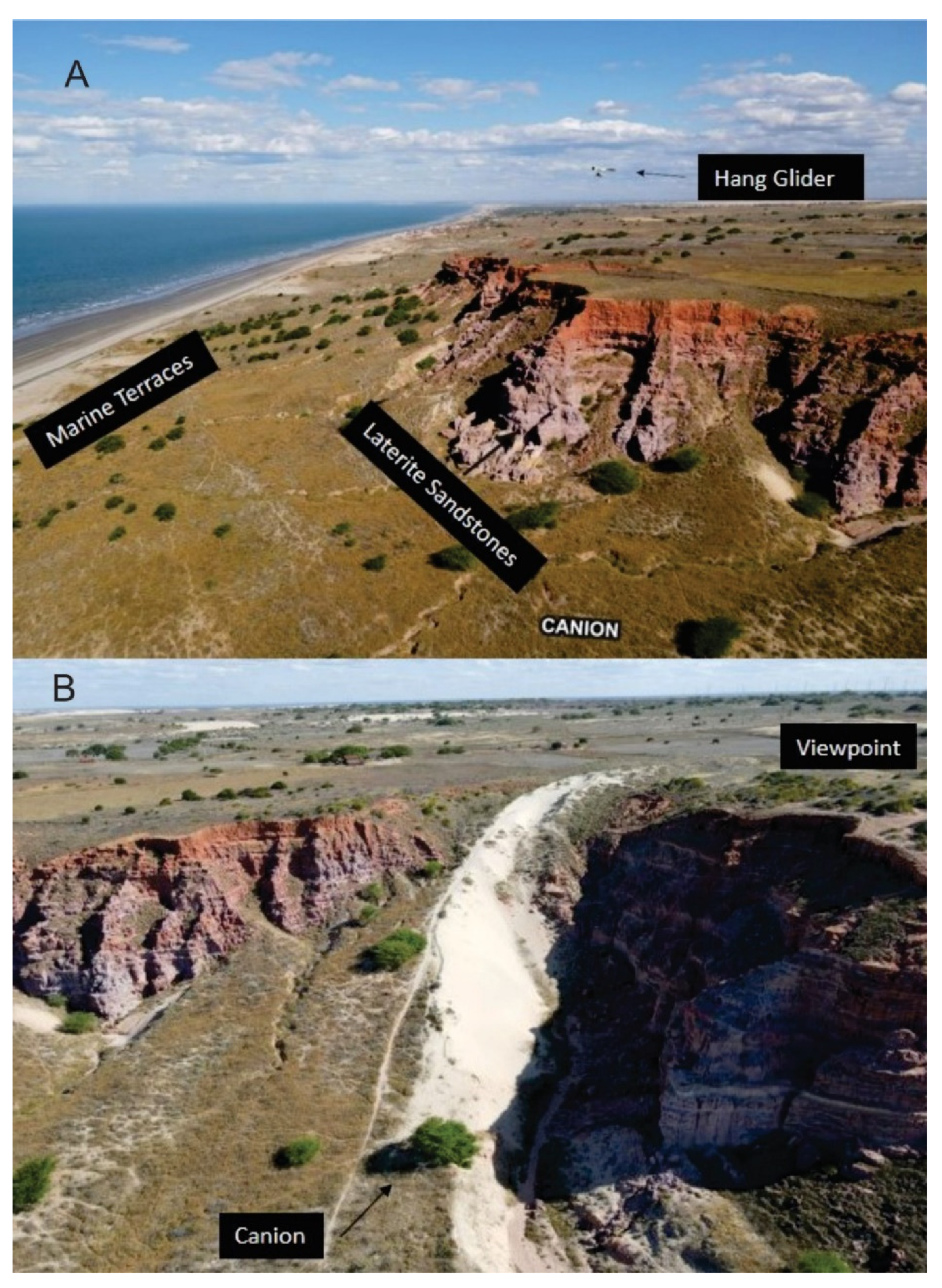
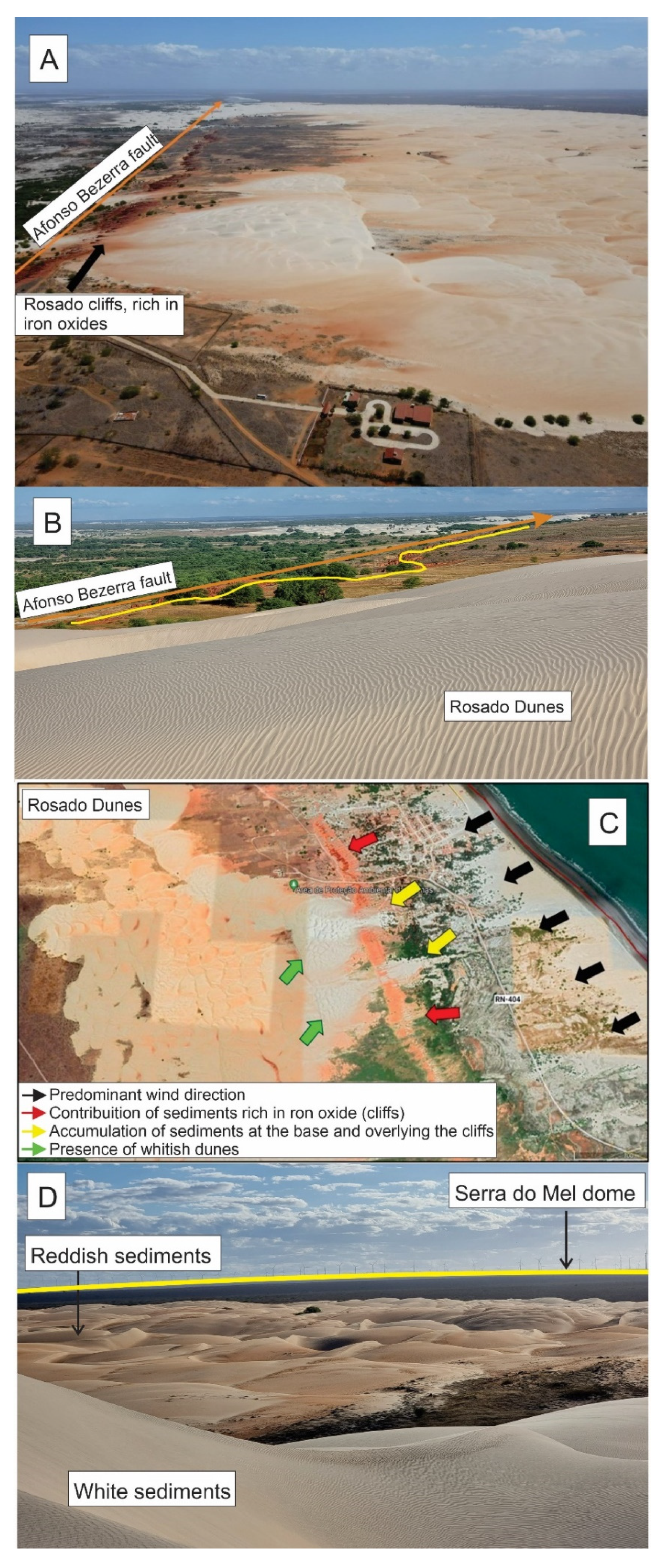
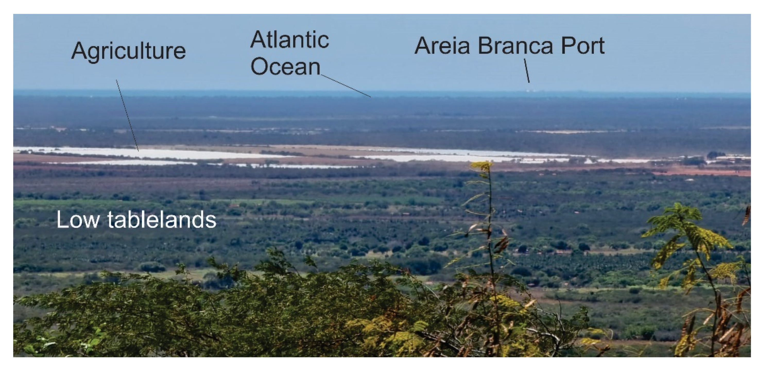
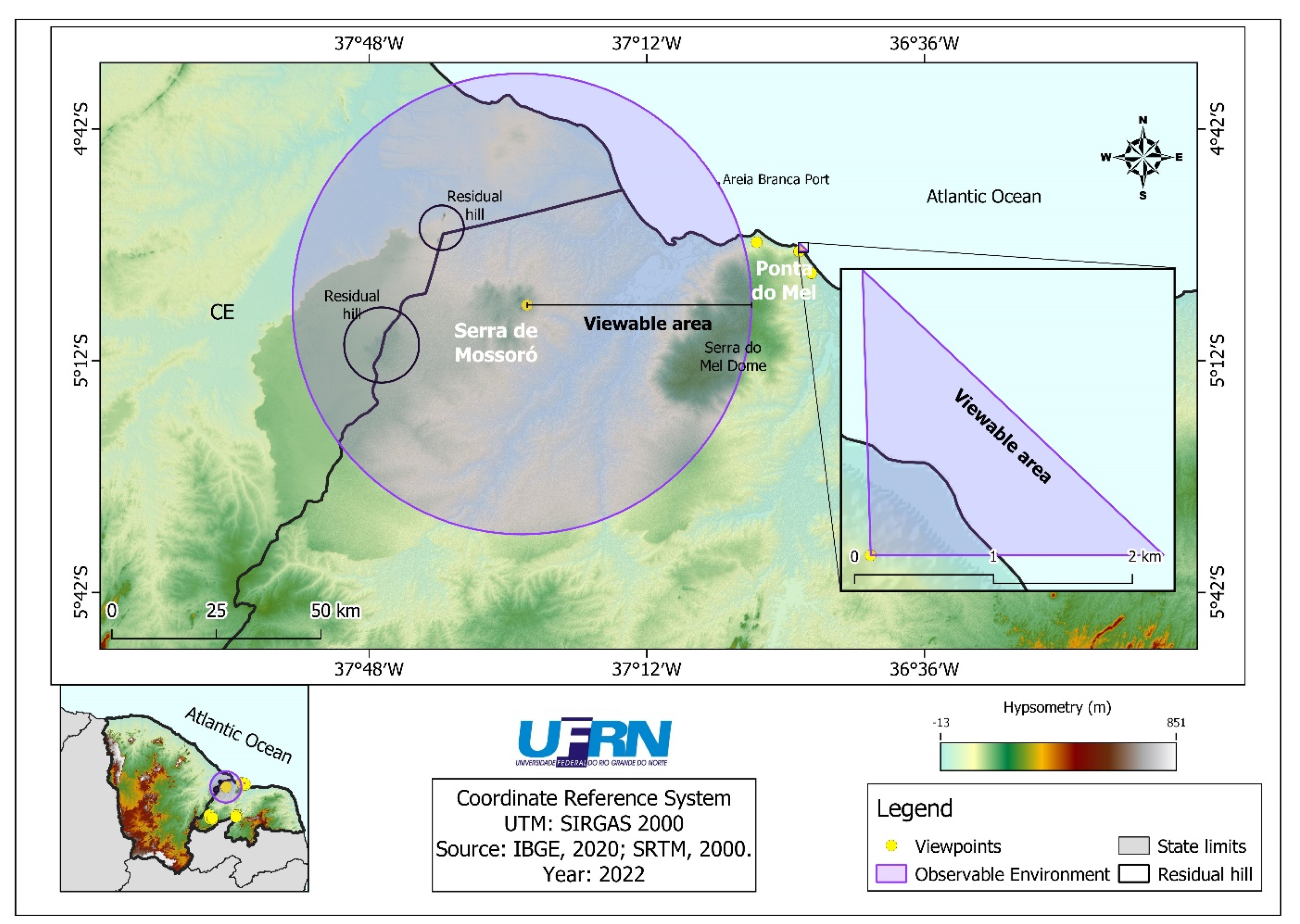
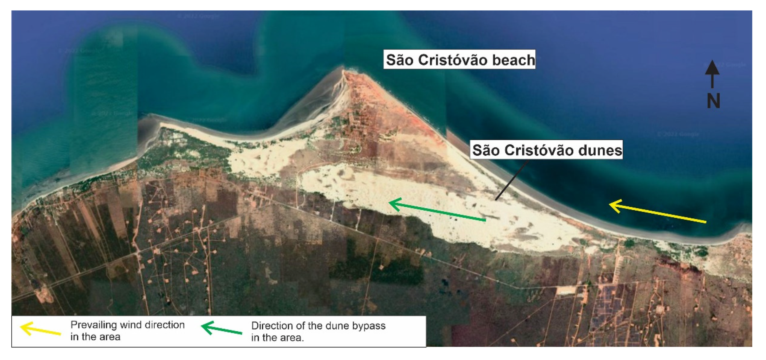
2.1. Study Area
2.2. The Methods
- Presence of geological elements;
- Presence of geoheritage elements;
- Presence of geomorphological elements;
- Presence of geomorphological heritage elements;
- Presence and type of vegetation cover;
- Presence of uncovered soil;
- Presence of water (rivers, lakes, and seas);
- Presence of snow/ice;
- Presence of cultural/historical elements (e.g., historical buildings);
- Degree of anthropogenic intervention (stress);
- Degree of landscape richness (number of different types of elements mentioned above);
- Degree of landscape degradation (because of natural processes such as rockfalls or anthropogenic processes such as massive construction, land abandonment, etc.);
- Degree of landscape cleanness (absence of garbage left by residents and/or tourists);
- Degree of landscape openness;
- Degree of landscape fragmentation (mosaic);
- Degree of landscape contrast (visual difference of landscape—for instance, by colour or by height of landscape elements); and
- Degree of visible component details belonging to landscape elements (this depends on both the distance to observable environments and the size of elements).
3. Results
4. Discussion
5. Conclusions
Author Contributions
Funding
Acknowledgments
Conflicts of Interest
References
- Gray, M. Geodiversity: Appreciation and Conservation of Abiotic Nature, 2nd ed.; John Wiley & Sons: Chichester, UK, 2013; 495p. [Google Scholar]
- Cendrero, A. Patrimonio geológico: Diagnóstico, clasificación y valoración. In Jornadas Sobre Património Geológico y Desarrollo Sostenible; SuárezValgrande, J.P., Ed.; Serie Monografías; Ministério de Medio Ambiente de España: Madrid, Spain, 2000; pp. 23–37. [Google Scholar]
- Panizza, M. Geomorphosites: Concepts, methods and examples of geomorphological survey. Chin. Sci. Bull. 2001, 46, 4–5. [Google Scholar] [CrossRef]
- Brilha, J.B.R. Geological Heritage and Geoconservation: The Conservation of Nature in Its Geological Aspect; Palimage: Sao Paulo, Brazil, 2005. [Google Scholar]
- Pralong, J.P. A method for assessing tourist potential and use of geomorphological sites. Géomorphol. Relief Process. Environ. 2005, 11, 189–196. [Google Scholar] [CrossRef]
- Reynard, E. Fiche D’inventaire des Géomorphosites. Université de Lausanne. Institute Geographie, Rapport Non-Publié. 2006. Available online: http://www.unil.ch/igul/page17893.html (accessed on 10 December 2021).
- Pereira, P.J.S. Geomorphological Heritage: Conceptualization, Evaluation and Disclosure. Aplicação ao Parque Natural de Montesinho. Ph.D Thesis, School of Science, University of Minho, Braga, Portugal, 2006. [Google Scholar]
- Reynard, E.; Fontana, G.; Kozlik, L.; Scapozza, C. A method for assessing scientific and additional values of geomorphosites. Geogr. Helv. 2007, 62, 148–158. [Google Scholar] [CrossRef]
- Lima, F.F. Methodological Proposal for the Inventory of Brazilian Geological Heritage. 103 f. Master’s Thesis, Geological Heritage and Geoconservation, School of Science, Minho’s University, Braga, Portugal, 2008. [Google Scholar]
- Garcia-Cortes, A.; Urqui, L.C. Methodological Document for the Elaboration of the Spanish Inventory of Sites of Geological Interest (IELIG); Version 11, 12-03-2009; Geological and Mining Institute of Spain: Madrid, Spain. Available online: http://w.igme.es/internet/patrimonio (accessed on 20 July 2022).
- Pereira, R.G.F.D.A. Geoconservation and Sustainable Development in the Chapada Diamantina (Bahia-Brazil). Ph.D. Thesis, University of Minho, Braga, Portugal, 2010. [Google Scholar]
- Brilha, J. Inventory and Quantitative assessment of geosites and geodiversity sites: A review. Geoheritage 2016, 8, 119–134. [Google Scholar] [CrossRef]
- Reynard, E.; Perret, A.; Bussard, J.; Grangier, L.; Martin, S. Integrated Approach for the Inventory and Management of Geomorphological Heritage at the Regional Scale. Geoheritage 2016, 8, 43–60. [Google Scholar] [CrossRef]
- Fuertes-Gutierrez, I.; Fernandez-Martinez, E. Geosites Inventory in the Leon Province (Northwestern Spain): A Tool to Introduce Geoheritage into Regional Environmental Management. Geoheritage 2010, 2, 57–75. [Google Scholar] [CrossRef]
- Migon, P.; Pijet-Migon, E. Viewpoint geosites—Values, conservation and management issues. Proc. Geol. Assoc. 2017, 128, 511–522. [Google Scholar] [CrossRef]
- Mikhailenko, A.V.; Ruban, D.A. Environment of viewpoint geosites: Evidence from the Western Caucasus. Land 2019, 8, 93. [Google Scholar] [CrossRef]
- Araujo, I.G.D. Geomorphodiversity of the Coastal Zone of Icapui/CE: Defining Geomorphosites by Scientific and Aesthetic Values. Master’s Dissertation, Pro-grama de Pós-Graduação e Pesquisa em Geografia, Universidade Federal do Rio Grande do Norte, Caicó, RN, Brazil, 2021. [Google Scholar]
- Diniz, M.T.M.; De Araujo, I.G.D.; Das Chagas, M.D. Comparative study of quantitative assessment of the geomorphological heritage of the coastal zone of Icapuí—Ceará, Brazil. Int. J. Geoheritage Park. 2022, 10, 124–142. [Google Scholar] [CrossRef]
- Maia, R.P.; Betard, F.; Bezerra, F.H.R. Geomorphology of the Portalegre and Martins Massifs—NE Brazil: Relief inversion under analysis. Rev. Bras. Geomorfol. 2016, 17, 273–285. Available online: http://lsie.unb.br/rbg/index.php/rbg/article/view/801 (accessed on 22 July 2022).
- Diniz, M.T.M.; Pereira, V.H.C. Climatology of Rio Grande do Norte: Acting atmospheric systems and mapping of climate types. Bol. Goiano Geogr. 2015, 35, 488–506. [Google Scholar]
- Dias, G.H.; Rodrigues, J.P.B.; Coelho, F.S.; Filgueira, R.F.; Peixoto, F.S. Extraction of Morphometric Attributes of the Mossoró Mountains (Mossoró-RN) from the Digital Elevation Model (DEM). Braz. J. Phys. Geogr. 2019, 12, 2239–2248. [Google Scholar]
- Maia, R.P.; Bezerra, F.H.R. Neotectonic Inversion of the Geography in the Potiguar Bacy, Northeast of Brazil. Braz. J. Geomorphol. 2014, 15, 61–74. [Google Scholar]
- Borges, F.E.S. Geopatrimony of the Municipalities of Porto do Mangue and Macau—RN. Master’s Dissertation, Center for Human Sciences, Letters and Arts, Graduate Program in Geography, Federal University of Rio Grande do Norte, Natal, RN, Brazil, 2022. [Google Scholar]
- Mikhailenko, A.V.; Eermolaev, V.A.; Ruban, D.A. Bridges as Geoheritage Viewpoints in the Western Caucasus. Geosciences 2021, 11, 377. [Google Scholar] [CrossRef]
- Kubalikova, L.; Kirchner, K.; Kuda, F. Viewpoint Geosites and Their Potential for Geoeducation and Geotourism; Public recreation and landscape protection—with environment hand in hand…: Conference proceedings; Mendel University in Brno: Brno, Czech Republic, 2022; pp. 440–445. [Google Scholar] [CrossRef]
- Mucivuna, V.C.; Garcia, M.G.M.; Reynard, E. Comparing quantitative methods on the evaluation of scientific value in geosites: Analysis from the Itatiaia National Park. Braz. Geomorphol. 2022, 396, 107988. [Google Scholar] [CrossRef]
- Kirillova, K.; Fu, X.; Lehto, X.; Cai, L. What makes a destination beautiful? Dimens. Tour. Aesthetic Judgm. Tour. Manag. 2014, 42, 282–293. [Google Scholar]


| Core Values—Visualised Landscape | |||
|---|---|---|---|
| Scientific Value | |||
| Criteria | Definition | Parameters | Score |
| A1—Diversity of visible geological/geomorphological features (forms and processes) | Amount of geological/geomorphological elements visible in the visualised landscape. | 1–4 viewable elements | 1 |
| 5–7 viewable elements | 2 | ||
| 8–9 viewable elements | 3 | ||
| ≥10 viewable elements | 4 | ||
| A2—Representativeness | Indicates the relevance of the site as a record of elements or processes related to the geomorphological evolution of the region and the context in which it is inserted, as well as the use of geomorphology for society. | Absence of any relevant aspect of scientific nature. | 1 |
| It contains illustrative records of elements or processes of geodiversity without expressiveness. | 2 | ||
| It contains illustrative elements that represent type sections of formations or are used as classic examples of geomorphological elements or processes or land use for society. | 3 | ||
| Containing a geoform that represents a classic form and processes of landscape evolution, the viewpoint allows unique aspects to be seen within a 200 km radius. | 4 | ||
| A3—Integrity | Indicates the conservation level of the viewable area and the possibility of viewing aspects of interest. | Altered observable area, the visualisation of aspects of interest is quite restricted, with no possibility of being easily retrieved. | 1 |
| Observable area altered, but still allows visualisation of aspects of interest with the possibility of recovery. | 2 | ||
| Observable area with some anthropic alteration, but human occupation does not limit the visualisation of the features of interest. | 3 | ||
| Observable area preserved without the need for reclamation or human use in no way affects the visualisation of aspects of geomorphological interest. | 4 | ||
| A4—Paleogeographic Value | The importance of the object for the reconstruction of the Earth’s climate and history (e.g., Cenozoic tectonic relief) is evaluated by this criterion. | It contains illustrative elements that represent paleogeographic evolution but shows anthropic alteration or the presence of vegetation. | 1 |
| It contains illustrative elements that represent the paleogeographic evolution, without the presence of alteration and vegetation cover, allowing excellent visualisation of the geomorphological elements. | 2 | ||
| A significant area for local paleogeographic understanding can be viewed. | 3 | ||
| A key area for understanding regional paleogeographic evolution can be visualised. | 4 | ||
| Classification | |||
| Very low | 1–4 | ||
| Low | 5–8 | ||
| Medium | 9–12 | ||
| High | 13–16 | ||
| Core Values—Visualised Landscape | |||
|---|---|---|---|
| Aesthetic Value | |||
| Criteria | Definition | Parameters | Score |
| B1—Overview | Angle from which you can observe the landscape | Restricted views on one or two sides | 0 |
| 120–180° panorama from one side only | 1 | ||
| 120–180° panorama on one side and restricted view on the other side. | 2 | ||
| 120–180° two-sided panoramas. | 3 | ||
| 360° Panorama | 4 | ||
| B2—Visibility of the geological/geomorphological characteristics of the landscape | Elements visualised in the landscape | Poor (very general view, presents obstacles such as vegetation, massifs, etc.). | 1 |
| Mixed (some features are more visible than others). | 2 | ||
| - | - | ||
| Excellent (all details are visible). | 4 | ||
| B3—Verticality | Height at which the viewpoint is located | Flat or gently undulating viewpoint. | 1 |
| Viewpoint on a strongly undulating relief. | 2 | ||
| Viewpoint on a residual hill or inselberg. | 3 | ||
| Viewpoint on an escarpment. | 4 | ||
| B4—Presence of water bodies | Existence of water in the landscape | Absence of water bodies | 1 |
| - | - | ||
| Lakes and/or Rivers | 2 | ||
| - | - | ||
| Ocean | 4 | ||
| B5—Colour contrast and individual elements | Contrasting colours from the RGB of an icnographic document and the presence of individual elements, such as an inselberg. Homogeneous landscape—composed of few and mostly similar elements. Heterogeneous landscape—composed of a complex configuration of very diverse elements, many contrasting colours and/or vibrant colours in the landscape | Homogeneous landscape without individual elements. | 1 |
| Homogeneous landscape with up to three individual elements. | 2 | ||
| 3–5 contrasting colours or heterogeneous landscape. | 3 | ||
| Contrast of 6 or more colours and heterogeneous landscape and/or vibrant colours in the landscape. | 4 | ||
| B6—Visualisable area (km2) | Area where you can observe the landscape from the viewpoint. | <50 km2 | 1 |
| 50 < 300 km2 | 2 | ||
| 300 < 500 km2 | 3 | ||
| >500 km2 | 4 | ||
| Rarity | Importance of the area visualised from the site in terms of its geomorphological occurrence in the investigated area | Visualised area of common occurrence in the study area, between 6 and 10 formations with similar characteristics can be viewed in the area, within the same geomorphological context within a radius of 200 km. | 1 |
| Up to 5 formations with similar characteristics can be viewed in the area, within the same geomorphological context within a 200 km radius. | 2 | ||
| Up to 3 formations with similar characteristics can be viewed in the area, within the same geomorphological context within a 200 km radius. | 3 | ||
| A unique formation can be viewed in the area within a 200 km radius or ≥3 within a 500 km radius. | 4 | ||
| Classification | |||
| Very low | 1–7 | ||
| Low | 8–14 | ||
| Medium | 15–21 | ||
| High | 22–28 | ||
| Supplementary Values—Own Site | |||
|---|---|---|---|
| Touristic Value | |||
| Criteria | Definition | Parameters | Score |
| C1—Accessibility | Indicative of difficulties in accessing the site. | Only by prepared pedestrians (e.g., in the case of suspension bridges). | 1 |
| By pedestrians only. | 2 | ||
| By cars with dirt roads. | 3 | ||
| By cars with paved roads. | 4 | ||
| C2—Tourism category | The existing tourism purposes in the area (sun and beach, geotourism, ecotourism, adventure, studies, sports, fishing, cultural, religious, etc.). | 0–1 type of tourism | 1 |
| 2 types of tourism | 2 | ||
| 3 types of tourism | 3 | ||
| 4 or more types of tourism | 4 | ||
| C3—Existence of use in progress | Indicates the current conditions of tourist use of the site. | Site without any current use or site with some visitation rate, but still incipient. | 1 |
| Site with average visitation rate and presence of accommodation. | 2 | ||
| Site with a high rate of visitation but without a mechanism to control visitors and with the presence of accommodation. | 3 | ||
| Site with a high rate of visitation and equipped with measures and the presence of lodging facilities less than 3 km away. | 4 | ||
| C4—Convenience | Pleasant built environment with the presence of bars, restaurants, inns, internet, banks, among others. | 0–1 convenience element. | 1 |
| 2 convenience elements. | 2 | ||
| 3–4 convenience elements. | 3 | ||
| ≥5 convenience elements. | 4 | ||
| C5—Signaling | Signs as a means of communication for tourists | Absence of signage. | 1 |
| Presence of identification plates, indicative and informative signs about the risks of the site. | 2 | ||
| Presence of indicative signs of abiotic relevance. | 3 | ||
| Interpretive panels of the area. | 4 | ||
| C6—Safety | Condition of being safe in place. Presence of fences, chest guards, warning signs about the exposed dangers, among others. | A steep or non-steep viewpoint with no protection for the visitor. | 1 |
| A viewpoint with 1 protection element for the visitor. | 2 | ||
| Viewpoint with more than 2 visitor protection elements. | 3 | ||
| Steep viewpoint (less than or greater than 45°) with more than 3 visitor protection elements. | 4 | ||
| Cultural Value | |||
| Criteria | Definition | Parameters | Score |
| D1—cultural relevance | It illustrates the site’s association with cultural elements. Use for religious purposes, place names, or holding cultural events. | No connection with cultural elements. | 1 |
| Indirect and direct relationship with cultural elements (ruins, place names, cave paintings) and/or craft activities. | 2 | ||
| Site with the presence of some cultural element which makes an ancillary contribution to the visit or use of the site. | 3 | ||
| Close relationship with cultural elements (cultural landscape), where the cultural aspect is one of the main attractions of the area. | 4 | ||
| Didactic Value | |||
| Criteria | Definition | Parameters | Score |
| E1—Didactic relevance | Potential of the site to illustrate geodiversity elements or processes and the possibility of using the site for teaching geosciences by schools. | It can be used for didactic purposes in graduate studies. | 1 |
| It can be used for didactic purposes for undergraduate students. | 2 | ||
| It can be used for teaching purposes for high school students. | 3 | ||
| It can be used for didactic purposes for the general public or elementary school students. | 4 | ||
| Classification | |||
| Very low | 1–8 | ||
| Low | 9–16 | ||
| Medium | 17–24 | ||
| High | 25–32 | ||
| Sites | Scientific Value | ||||
|---|---|---|---|---|---|
| A1 | A2 | A3 | A4 | Total | |
| Ponta da Serra Viewpoint (Portalegre) | 4 | 4 | 4 | 4 | 16 |
| Rosado Dunes—Porto do Mangue | 4 | 4 | 4 | 4 | 16 |
| Ponta do Mel Viewpoint | 4 | 4 | 4 | 4 | 16 |
| Sunset Viewpoint—Triunfo Potiguar | 2 | 4 | 4 | 4 | 14 |
| Serra de Mossoró Viewpoint | 2 | 4 | 4 | 4 | 14 |
| Muriçoca Viewpoint—Jucurutu | 4 | 4 | 4 | 2 | 14 |
| Sunset Viewpoint of Diadema—Martins | 3 | 3 | 4 | 4 | 14 |
| “Viewpoint Under Construction”—Martins | 2 | 4 | 4 | 3 | 13 |
| Tota’s Viewpoint—Serrinha dos Pintos | 2 | 3 | 4 | 3 | 12 |
| Novo Mundo viewpoint—Jucurutu | 2 | 3 | 4 | 3 | 12 |
| Boa Vista Viewpoint—Portalegre | 2 | 3 | 4 | 3 | 12 |
| São Cristóvão Dunes—Areia Branca | 2 | 3 | 3 | 3 | 11 |
| Classification | |||||
| Very low | 1–4 | ||||
| Low | 5–8 | ||||
| Medium | 9–12 | ||||
| High | 13–16 | ||||
| Sites | Aesthetic Value | |||||||
|---|---|---|---|---|---|---|---|---|
| B1 | B2 | B3 | B4 | B5 | B6 | B7 | Total | |
| Serra de Mossoró Viewpoint | 4 | 4 | 3 | 4 | 3 | 4 | 4 | 26 |
| Ponta do Mel Viewpoint | 3 | 4 | 4 | 4 | 4 | 1 | 4 | 24 |
| Rosado Dunes—Porto do Mangue | 4 | 4 | 2 | 4 | 4 | 1 | 4 | 23 |
| “Viewpoint Under Construction”—Martins | 2 | 4 | 4 | 1 | 3 | 4 | 4 | 22 |
| São Cristóvão Dunes—Areia Branca | 4 | 4 | 2 | 4 | 3 | 1 | 4 | 22 |
| Ponta da Serra Viewpoint (Portalegre) | 4 | 4 | 2 | 1 | 3 | 4 | 2 | 20 |
| Muriçoca Viewpoint—Jucurutu | 2 | 4 | 2 | 1 | 3 | 4 | 4 | 20 |
| Tota’s Viewpoint—Serrinha dos Pintos | 2 | 4 | 2 | 1 | 3 | 4 | 2 | 18 |
| Sunset Viewpoint—Triunfo Potiguar | 2 | 4 | 2 | 1 | 3 | 4 | 2 | 18 |
| Sunset Viewpoint of Diadema—Martins | 1 | 4 | 4 | 1 | 3 | 1 | 4 | 18 |
| Novo Mundo Viewpoint—Jucurutu | 2 | 4 | 2 | 1 | 3 | 3 | 2 | 17 |
| Boa Vista Viewpoint—Portalegre | 1 | 4 | 4 | 1 | 3 | 1 | 2 | 16 |
| Classification | ||||||||
| Very low | 1–7 | |||||||
| Low | 8–14 | |||||||
| Medium | 15–21 | |||||||
| High | 22–28 | |||||||
| Sites | Additional Values | ||||||||
|---|---|---|---|---|---|---|---|---|---|
| C | D | E | Total | ||||||
| C1 | C2 | C3 | C4 | C5 | C6 | D1 | E1 | ||
| Ponta do Mel Viewpoint | 3 | 3 | 2 | 3 | 3 | 3 | 4 | 4 | 25 |
| Boa Vista Viewpoint—Portalegre | 3 | 2 | 4 | 4 | 1 | 2 | 1 | 4 | 21 |
| Rosado Dunes—Porto do Mangue | 4 | 2 | 2 | 3 | 2 | 1 | 4 | 3 | 21 |
| Tota’s Viewpoint—Serrinha dos Pintos | 3 | 2 | 3 | 3 | 1 | 1 | 3 | 4 | 20 |
| Sunset Viewpoint—Triunfo Potiguar | 3 | 3 | 1 | 2 | 1 | 2 | 3 | 4 | 19 |
| Serra de Mossoró Viewpoint | 4 | 2 | 3 | 2 | 1 | 1 | 0 | 4 | 17 |
| Sunset Viewpoint of Diadema—Martins | 4 | 2 | 2 | 1 | 1 | 2 | 1 | 4 | 17 |
| São Cristóvão Dunes—Areia Branca | 4 | 1 | 1 | 3 | 1 | 1 | 1 | 4 | 16 |
| Novo Mundo Viewpoint—Jucurutu | 3 | 1 | 1 | 1 | 1 | 1 | 3 | 4 | 15 |
| Ponta da Serra Viewpoint (Portalegre) | 3 | 1 | 1 | 1 | 1 | 1 | 1 | 4 | 13 |
| “Viewpoint under construction”—Martins | 3 | 2 | 1 | 2 | 1 | 1 | 1 | 2 | 13 |
| Muriçoca Viewpoint—Jucurutu | 3 | 1 | 1 | 1 | 1 | 1 | 1 | 4 | 13 |
| Classification | |||||||||
| Very low | 1–8 | ||||||||
| Low | 9–16 | ||||||||
| Medium | 17–24 | ||||||||
| High | 25–32 | ||||||||
Publisher’s Note: MDPI stays neutral with regard to jurisdictional claims in published maps and institutional affiliations. |
© 2022 by the authors. Licensee MDPI, Basel, Switzerland. This article is an open access article distributed under the terms and conditions of the Creative Commons Attribution (CC BY) license (https://creativecommons.org/licenses/by/4.0/).
Share and Cite
Diniz, M.T.M.; de Araújo, I.G.D. Proposal of a Quantitative Assessment Method for Viewpoint Geosites. Resources 2022, 11, 115. https://doi.org/10.3390/resources11120115
Diniz MTM, de Araújo IGD. Proposal of a Quantitative Assessment Method for Viewpoint Geosites. Resources. 2022; 11(12):115. https://doi.org/10.3390/resources11120115
Chicago/Turabian StyleDiniz, Marco Túlio Mendonça, and Isa Gabriela Delgado de Araújo. 2022. "Proposal of a Quantitative Assessment Method for Viewpoint Geosites" Resources 11, no. 12: 115. https://doi.org/10.3390/resources11120115
APA StyleDiniz, M. T. M., & de Araújo, I. G. D. (2022). Proposal of a Quantitative Assessment Method for Viewpoint Geosites. Resources, 11(12), 115. https://doi.org/10.3390/resources11120115