
Assessing the Educational Potential of Geosites: Introducing a Method Using Inquiry-Based Learning


Abstract
:1. Introduction
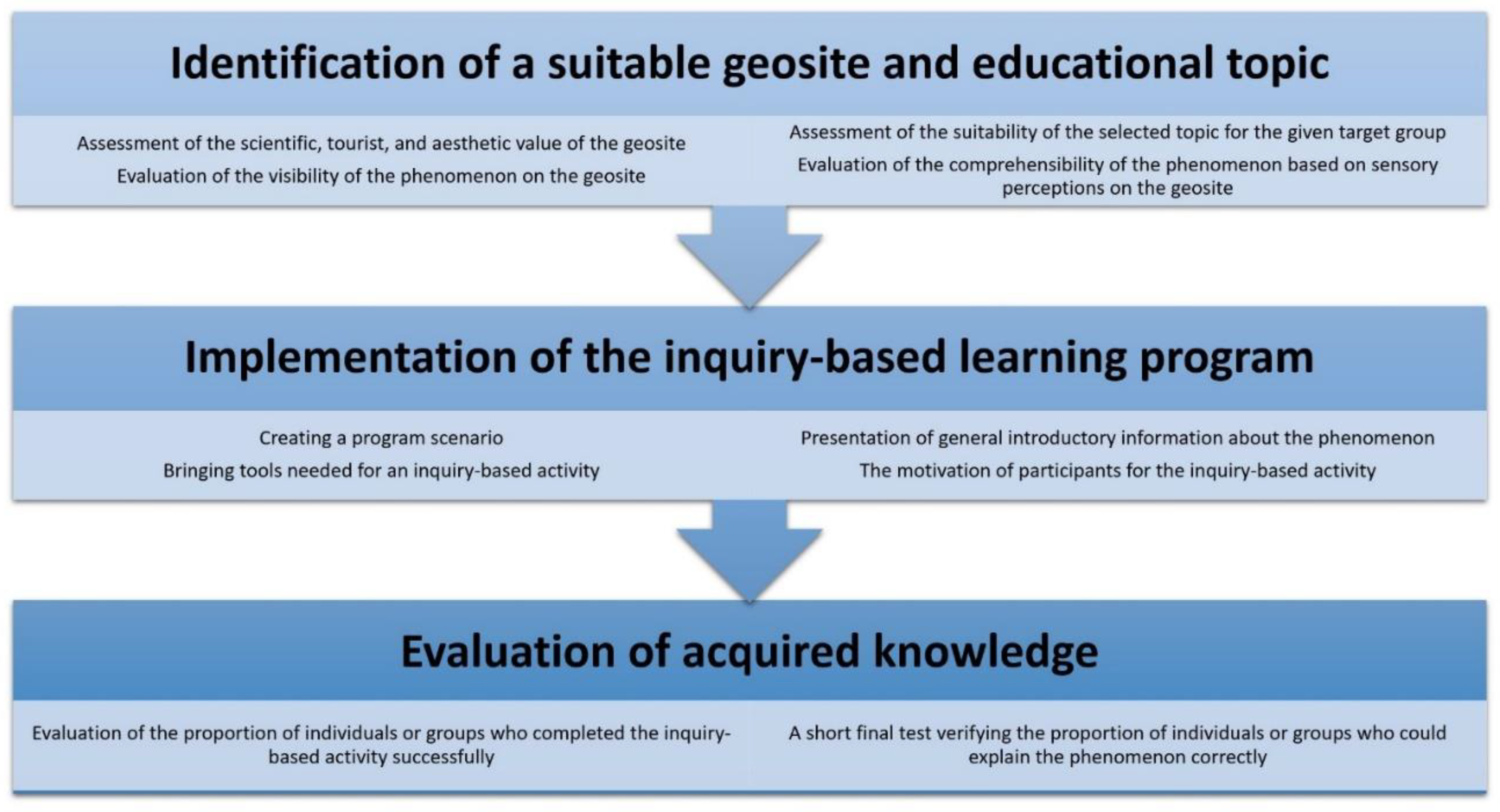
2. Materials and Methods
Description of the Experiment
3. Results
4. Discussion
5. Conclusions
Funding
Institutional Review Board Statement
Informed Consent Statement
Data Availability Statement
Conflicts of Interest
References
- Strba, L.; Krsak, B.; Sidor, C. Some Comments to Geosite Assessment, Visitors, and Geotourism Sustainability. Sustainability 2018, 10, 2589. [Google Scholar] [CrossRef] [Green Version]
- Strba, L.; Rybar, P.; Balaz, B.; Moloka, M.; Hvizdak, L.; Krsak, B.; Lukac, M.; Muchova, L.; Tometzova, D.; Ferencikova, J. Geosite assessments: Comparison of methods and results. Curr. Issues Tour. 2015, 18, 496–510. [Google Scholar] [CrossRef]
- Brilha, J. Inventory and Quantitative Assessment of Geosites and Geodiversity Sites: A Review. Geoheritage 2016, 8, 119–134. [Google Scholar] [CrossRef] [Green Version]
- Pal, M.; Albert, G. Examining the Spatial Variability of Geosite Assessment and Its Relevance in Geosite Management. Geoheritage 2021, 13, 8. [Google Scholar] [CrossRef]
- Pereira, P.; Pereira, D. Methodological guidelines for geomorphosite assessment. Geomorphol. Relief Process. Environ. 2010, 2, 215–222. [Google Scholar] [CrossRef] [Green Version]
- Pereira, D.I.; Pereira, P.; Brilha, J.; Santos, L. Geodiversity Assessment of Parana State (Brazil): An Innovative Approach. Environ. Manag. 2013, 52, 541–552. [Google Scholar] [CrossRef] [Green Version]
- Kubalikova, L.; Drapela, E.; Kirchner, K.; Bajer, A.; Balkova, M.; Kuda, F. Urban geotourism development and geoconservation: Is it possible to find a balance? Environ. Sci. Policy 2021, 121, 1–10. [Google Scholar] [CrossRef]
- Tomic, N.; Bozic, S. A modified Geosite Assessment Model (M-GAM) and its Application on the Lazar Canyon area (Serbia). Int. J. Environ. Res. 2014, 8, 1041–1052. [Google Scholar]
- Golfinopoulos, V.; Papadopoulou, P.; Koumoutsou, E.; Zouros, N.; Fassoulas, C.; Zelilidis, A.; Iliopoulos, G. Quantitative Assessment of the Geosites of Chelmos-Vouraikos UNESCO Global Geopark (Greece). Geosciences 2022, 12, 63. [Google Scholar] [CrossRef]
- Pourahmad, A.; Hosseini, A.; Pourahmad, A.; Zoghi, M.; Sadat, M. Tourist Value Assessment of Geotourism and Environmental Capabilities in Qeshm Island, Iran. Geoheritage 2018, 10, 687–706. [Google Scholar] [CrossRef]
- Chrobak, A. Review of the assessment methods of aEiotic nature sites used in geotourism. Stud. Ind. Geogr. Comm. Pol. Geogr. Soc. 2021, 35, 116–145. [Google Scholar] [CrossRef]
- Drapela, E. Geotouristic potential of former quarries in Northern Bohemia. IOP Conf. Ser. Earth Environ. Sci. 2020, 609, 012079. [Google Scholar] [CrossRef]
- Cho, H.; Kim, J.S.; Kang, H.C.; Park, J.W.; Shin, S.; Chae, Y.U.; Ha, S.; Kim, H.S.; Lim, H.S. Geological values of the Ueumdo geosite in the Hwaseong Geopark, Korea and its application to geo-education. J. Geol. Soc. Korea 2021, 57, 257–273. [Google Scholar] [CrossRef]
- Lopes, F.C.; Ramos, A.M.; Gomes, C.R.; Ussombo, C.C. The geoheritage of Lubango-Tundavala road traverse in the Serra da Leba (SW Angola): Outcrops characterization and numerical assessment for outdoor educational activities and geoconservation purpose. J. Afr. Earth Sci. 2019, 157, 103510. [Google Scholar] [CrossRef]
- Drapela, E.; Bohm, H. Interpretation of secondary geodiversity: Experience from geotouristic guide practice. In Public Recreation and Landscape Protection—With Sense Hand in Hand; Fialová, J., Ed.; Mendel University in Brno: Brno, Czech Republic, 2019; pp. 235–238. ISBN 978-807509715-6. [Google Scholar]
- Pedaste, M.; Maeots, M.; Siiman, L.A.; de Jong, T.; van Riesen, S.A.N.; Kamp, E.T.; Manoli, C.C.; Zacharia, Z.C.; Tsourlidaki, E. Phases of inquiry-based learning: Definitions and the inquiry cycle. Educ. Res. Rev. 2015, 14, 47–61. [Google Scholar] [CrossRef] [Green Version]
- Karamustafaogu, S.; Havuz, A.C. Inquiry-Based Learning and Its Effectiveness. Int. J. Assess. Tools Educ. 2016, 3, 40–54. [Google Scholar]
- Cleverly, D. Inquiry-based learning: Facilitators’ perceptions of their effectiveness in the tutorial process. Int. J. Nurs. Stud. 2003, 40, 829–841. [Google Scholar] [CrossRef]
- Briggs, M.; Long, G.; Owens, K. Qualitative Assessment of Inquiry-Based Teaching Methods. J. Chem. Educ. 2011, 88, 1034–1040. [Google Scholar] [CrossRef]
- Horne, M.; Woodhead, K.; Morgan, L.; Smithies, L.; Megson, D.; Lyte, G. Using enquiry in learning: From vision to reality in higher education. Nurse Educ. Today 2007, 27, 103–112. [Google Scholar] [CrossRef]
- Cihakova, K. IBSE and Outdoor Education Activates Both Children and Teachers. In Project-Based Education and Other Activating Strategies in Science Education XVIII (PBE 2020); Rusek, M., Tothova, M., Vojir, K., Eds.; Jihoceska Univ: Ceske Budejovice, Czech Republic, 2021; pp. 26–35. [Google Scholar]
- Beck, L.; Cable, T. Interpretation for the 21st Century: Fifteen Guiding Principles for Interpreting Nature and Culture; Sagamore Publishing: Champaign, IL, USA, 2002; p. 256. ISBN 978-1-57167-1331. [Google Scholar]
- Beck, L.; Cable, T. The Gifts of Interpretation. Fifteen Guiding Principles for Interpreting Nature and Culture; Sagamore Publishing: Urbana, IL, USA, 2011; p. 205. ISBN 978-1-57167-636-8. [Google Scholar]
- Ham, S. Environmental Interpretation; Fulcrum Publishing: Wheat Ridge, CO, USA, 1992; p. 486. ISBN 1555919022. [Google Scholar]
- Ham, S. Interpretation—Making a Difference on Purpose; Fulcrum Publishing: Golden, CO, USA, 2013; p. 320. ISBN 1555917429. [Google Scholar]
- Tilden, F. Interpreting Our Heritage; The University of North Carolina Press: Chapell Hill, NC, USA, 1957; p. 120. [Google Scholar]
- Kostak, M.; Cech, S.; Ekrt, B.; Mazuch, M.; Wiese, F.; Voigt, S.; Wood, C.J. Belemnites of the Bohemian Cretaceous Basin in a global context. Acta Geol. Pol. 2004, 54, 511-U20. [Google Scholar]
- Chlupac, I.; Brzobohaty, R.; Kovanda, J.; Stranik, Z. Geologická minulost České republiky (Geological past of the Czech Republic); Academia: Praha, Czech Republic, 2002. [Google Scholar]
- Migon, P.; Pijet-Migon, E. Exploring Causal Relationships for Geoheritage Interpretation—Variable Effects of Cenozoic Volcanism in Central European Sedimentary Tablelands. Geoheritage 2022, 14, 9. [Google Scholar] [CrossRef]
- Czech Geological Survey. Geological Map 1: 50,000. Map Application. Available online: https://mapy.geology.cz/geocr50/# (accessed on 15 October 2022).
- Bohac, A.; Drapela, E. Overtourism Hotspots: Both a Threat and Opportunity for Rural Tourism. Eur. Countrys. 2022, 14, 157–179. [Google Scholar] [CrossRef]
- Drapela, E. Overtourism in the Czech Sandstone Rocks: Causes of the problem, the current situation and possible solutions. In Proceedings of the 3rd International Conference on Tourism Research ICTR 2020, Valencia, Spain, 27–28 March 2020; Marti-Parreno, J., Gomez-Calvet, R., Munoz, J., Eds.; ACPI: Reading, UK, 2020; pp. 35–42, ISBN 9781912764556. [Google Scholar]
- Drapela, E. Prevention of damage to sandstone rocks in protected areas of nature in northern Bohemia. AIMS Geosci. 2021, 7, 56–73. [Google Scholar] [CrossRef]
- Prabhakar, B.C.; Radhika, K.N. Recognizing New Geoheritage Sites in Karnataka, India. Geoheritage 2022, 14, 3. [Google Scholar] [CrossRef]
- Morcior, E.; Kruse, M. Educational values and services of ecosystems and landscapes—An overview. Ecol. Indic. 2016, 60, 137–151. [Google Scholar] [CrossRef]
- Fassoulas, C.; Mouriki, D.; Dimitriou-Nikolakis, P.; Iliopoulos, G. Quantitative assessment of geotopes as an effective tool for geoheritage management. Geoheritage 2012, 4, 177–193. [Google Scholar] [CrossRef]
- Chatzopoulou, D.I.; Economides, A.A. Adaptive assessment of student’s knowledge in programming courses. J. Comput. Assist. Learn. 2010, 26, 258–269. [Google Scholar] [CrossRef]
- Shahbazova, S.N. Decision-Making in Determining the Level of Knowledge of Students in the Learning Process under Uncertainty. Inform.—J. Comput. Inform. 2013, 37, 339–343. [Google Scholar]
- Gottfredson, L.S. Logical Fallacies Used to Dismiss the Evidence on Intelligence Testing. In Correcting Fallacies about Educational and Psychological Testing; Phelps, Richard, F., Eds.; American Psychological Association: Washington, DC, USA, 2009; ISBN 978-1-4338-0392-5. [Google Scholar]


| Category | An Example of a Target Group |
|---|---|
| 1 | Kindergarten children |
| 2 | Primary school children |
| 3 | Secondary school children, ordinary tourist |
| 4 | High school student, a layperson with a mild interest in geology (ordinary geotourist) |
| 5 | University student (relevant field), a layperson with a deeper interest in geology (member of a natural science association, reader of popular geological literature, etc.) |
| 6 | Professional |
| Main topic | Geological Evolution of the Surrounding Landscape |
|---|---|
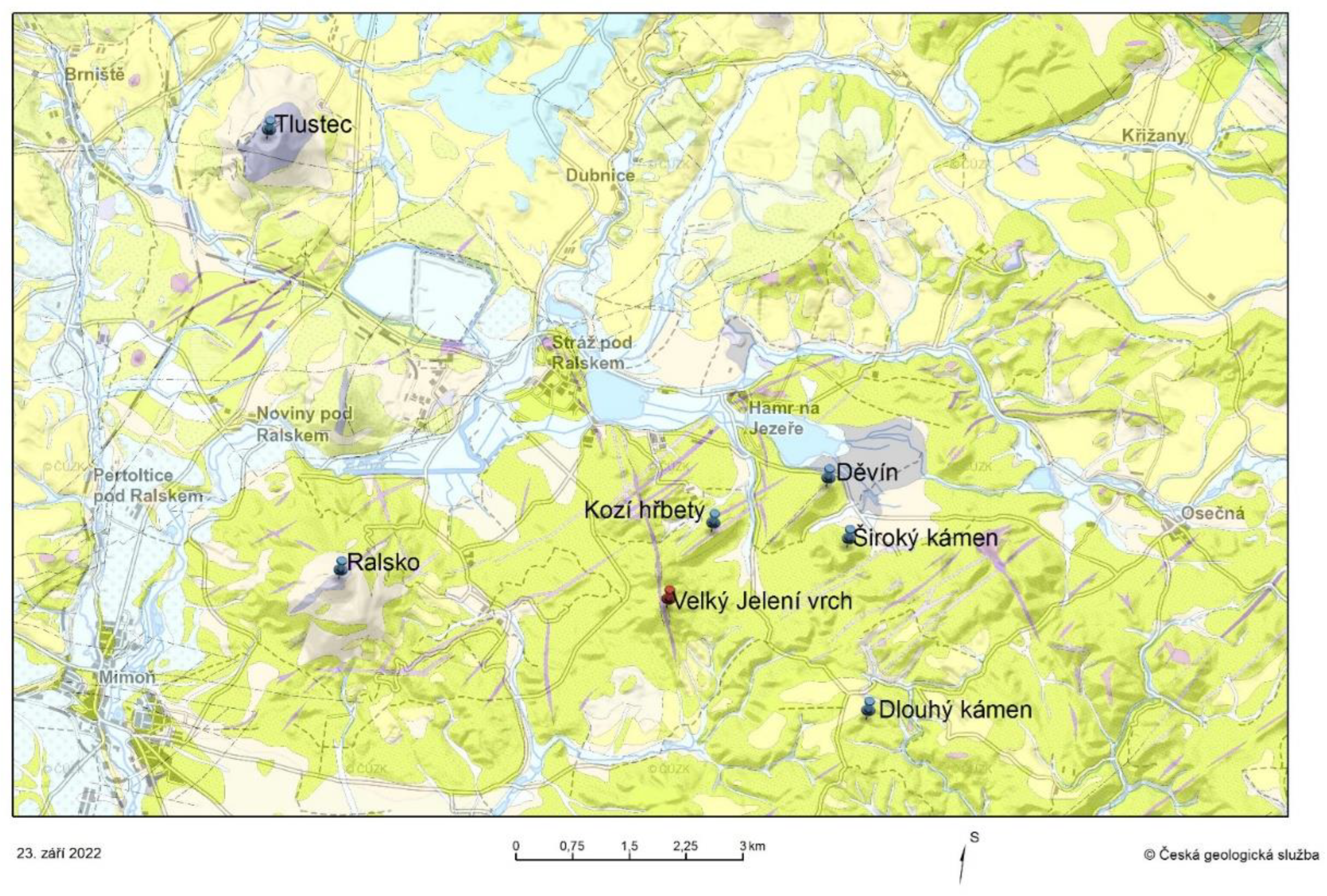
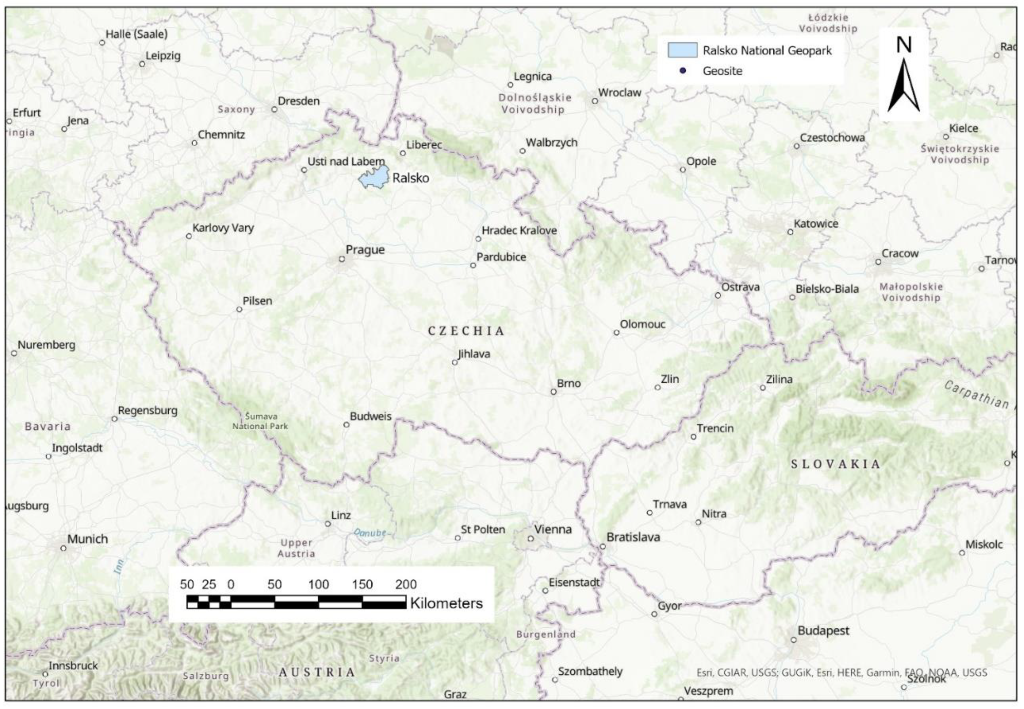
| Place | Velký Jelení vrch, the northern part of the Ralsko National Geopark, the northern edge of the Bohemian Cretaceous Basin. |
| Target group | Category 5 and lower. |
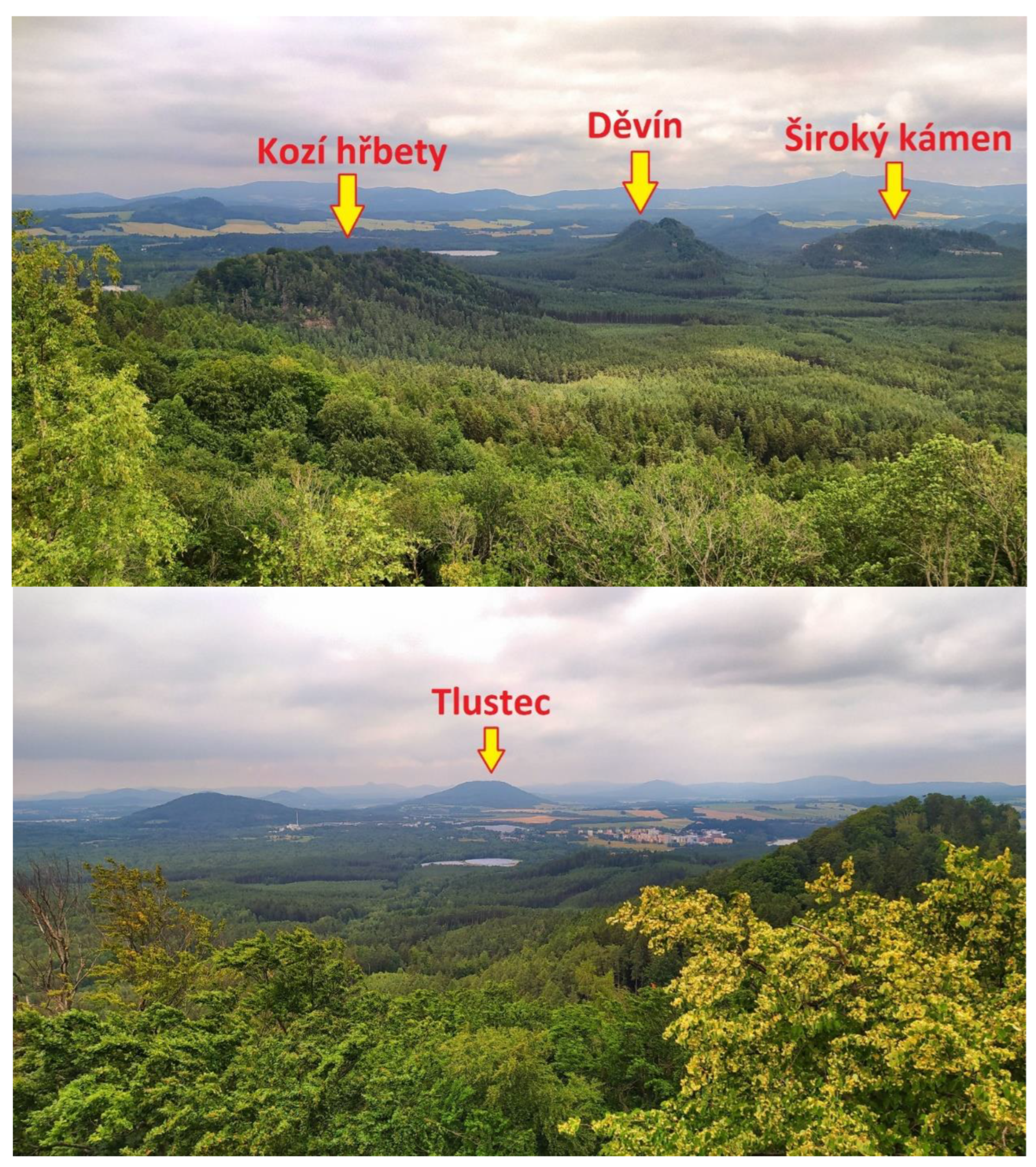
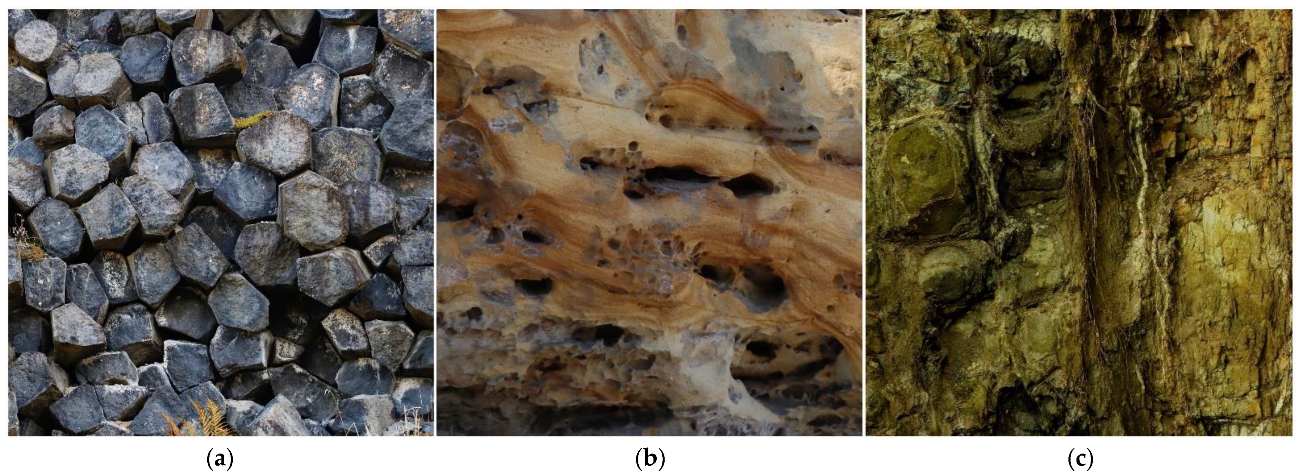
| Excursion design | The starting point is the village of Hamr na Jezeře, from where the 12 km long circuit starts. During the first eight kilometers, participants will encounter the three main types of rocks in the area and see the specific relief shapes they create. However, the guide does not explain their genesis. An inquiry-based activity follows. In the last third of the journey, the knowledge gained during the inquiry-based activity is repeated so that even individuals who could not successfully complete it can understand its message. |
| Inquiry-based activity setting | We are located on a viewpoint from where there is a nice view of the surrounding hills. Try to create a simple panoramic sketch in which you name these hills and write down what kind of rocks they are made of. A geological map will help you with this. Next, try to find out in which order these rocks were formed and how they affect the shape of the hills they form. Finally, try to create a short (5–7 sentences) “story of the evolution of the surrounding landscape”, in which you simply explain how what we see was created. You can use the internet on your mobile for this. |
| Necessary tools for inquiry-based activity | A section of the geological map of the area with a good topographic background. |
| Assessing the success of an inquiry-based activity | The participant should be able to identify some examples of hills made up of all three main rock types found in the area. Furthermore, he should be able to define how their shapes differ, in what order they were created, and during which processes. If he gives these data correctly or almost correctly (with some small errors), the result of his activity is evaluated as successful. |
| Short final test setting | A text of 10 sentences in length, in which some terms or parts of the explanation are omitted, which the participants have to complete. In total, participants have to complete 11 words or parts of sentences. The test takes about 5 min to complete, and participants are not allowed to cooperate. |
| Assessing the success of a short final test | If the test is completed correctly or with one error, the result is considered successful. |
| Category | Number of Participants/Groups | The Inquiry-Based Activity Success Rate | The Final Test Success Rate |
|---|---|---|---|
| 5 | 42/21 | 90.47% | 95.23% |
| 44/22 | 86.36% | 90.90% | |
| 4 | 28/14 | 78.57% | 85.71% |
| 26/13 | 69.23% | 84.61% | |
| 37/13 | 84.61% | 76.92% | |
| 3 | 28/14 | 42.86% | 57.14% |
| 24/8 | 50.00% | 62.50% |
| Suitability for Categories | The Nature of the Educational Program | Suitable Geosite |
|---|---|---|
| 1 + 2 | Primarily playful form, very simple message. | Near the starting point, scientific value is not important. |
| 2 | A slightly professional program for children interested in nature. | A place where you can do some interesting activities (collecting minerals and fossils, panning, rock climbing, etc.). |
| 3 | The program is closely related to the curriculum currently being discussed at secondary school. | An attractive geosite, the focus of the program is often narrowly defined, so the potential of the geosite cannot always be used sufficiently. |
| 3 + 4 + 5 | A classic excursion for the general public, for whom no greater knowledge is assumed. | An attractive geosite where an interesting story can be presented. |
| 4 + 5 | An excursion aimed at a motivated geotourist or a student of a specialized school. | Geosite with a balanced ratio of attractiveness and professional interest. The main message of the excursion is more difficult to understand. |
| 5 (6) | A visit to a site of professional interest. | A geosite of high scientific value. |
Publisher’s Note: MDPI stays neutral with regard to jurisdictional claims in published maps and institutional affiliations. |
© 2022 by the author. Licensee MDPI, Basel, Switzerland. This article is an open access article distributed under the terms and conditions of the Creative Commons Attribution (CC BY) license (https://creativecommons.org/licenses/by/4.0/).
Share and Cite
Drápela, E. Assessing the Educational Potential of Geosites: Introducing a Method Using Inquiry-Based Learning. Resources 2022, 11, 101. https://doi.org/10.3390/resources11110101
Drápela E. Assessing the Educational Potential of Geosites: Introducing a Method Using Inquiry-Based Learning. Resources. 2022; 11(11):101. https://doi.org/10.3390/resources11110101
Chicago/Turabian StyleDrápela, Emil. 2022. "Assessing the Educational Potential of Geosites: Introducing a Method Using Inquiry-Based Learning" Resources 11, no. 11: 101. https://doi.org/10.3390/resources11110101
APA StyleDrápela, E. (2022). Assessing the Educational Potential of Geosites: Introducing a Method Using Inquiry-Based Learning. Resources, 11(11), 101. https://doi.org/10.3390/resources11110101