Flood Risk Analysis with Explainable Geospatial Artificial Intelligence (GeoAI) Techniques
Abstract
1. Introduction
2. Materials and Methods
2.1. Study Area
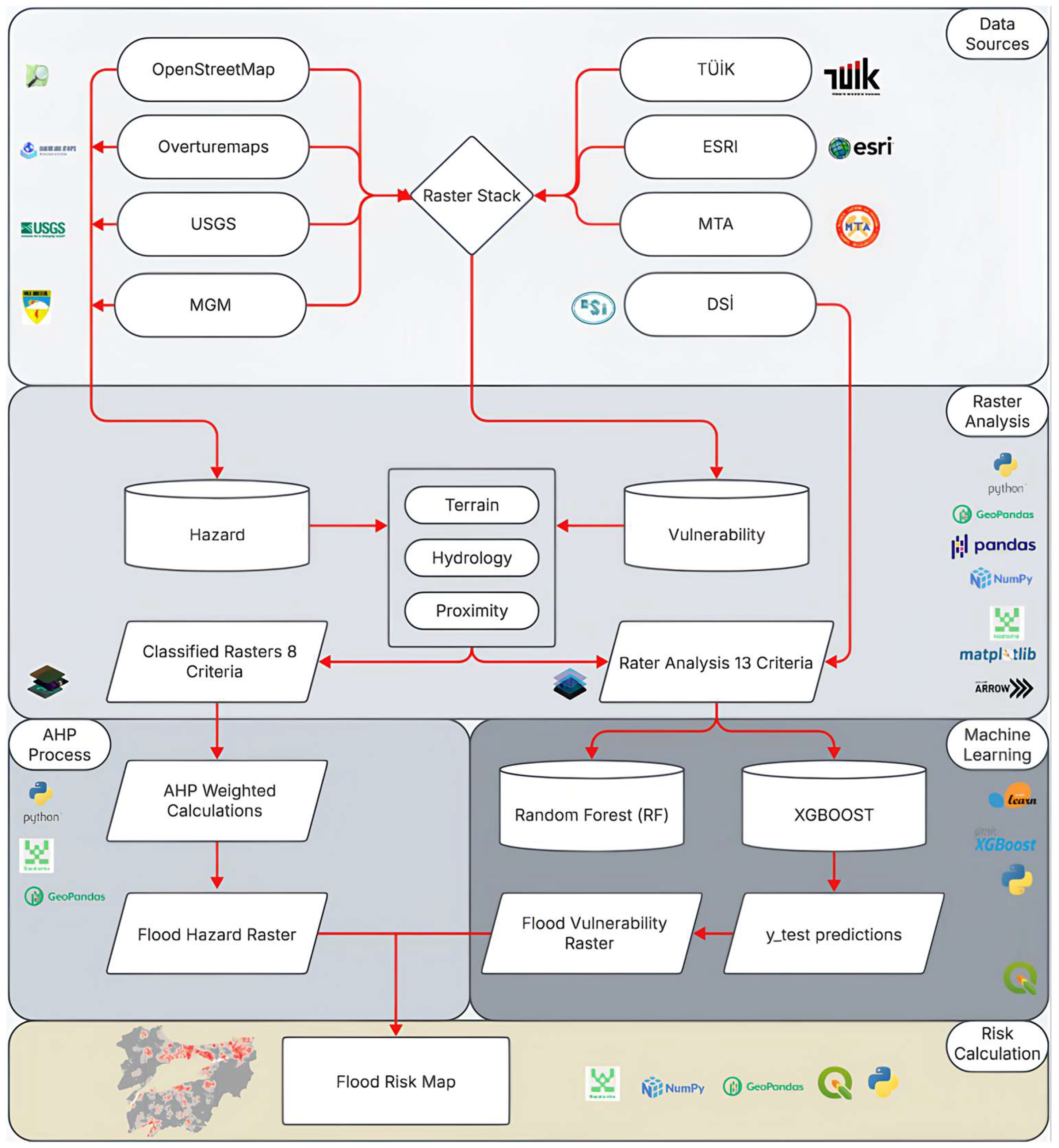
2.2. Flood Risk Analysis with Explainable GeoAI Techniques
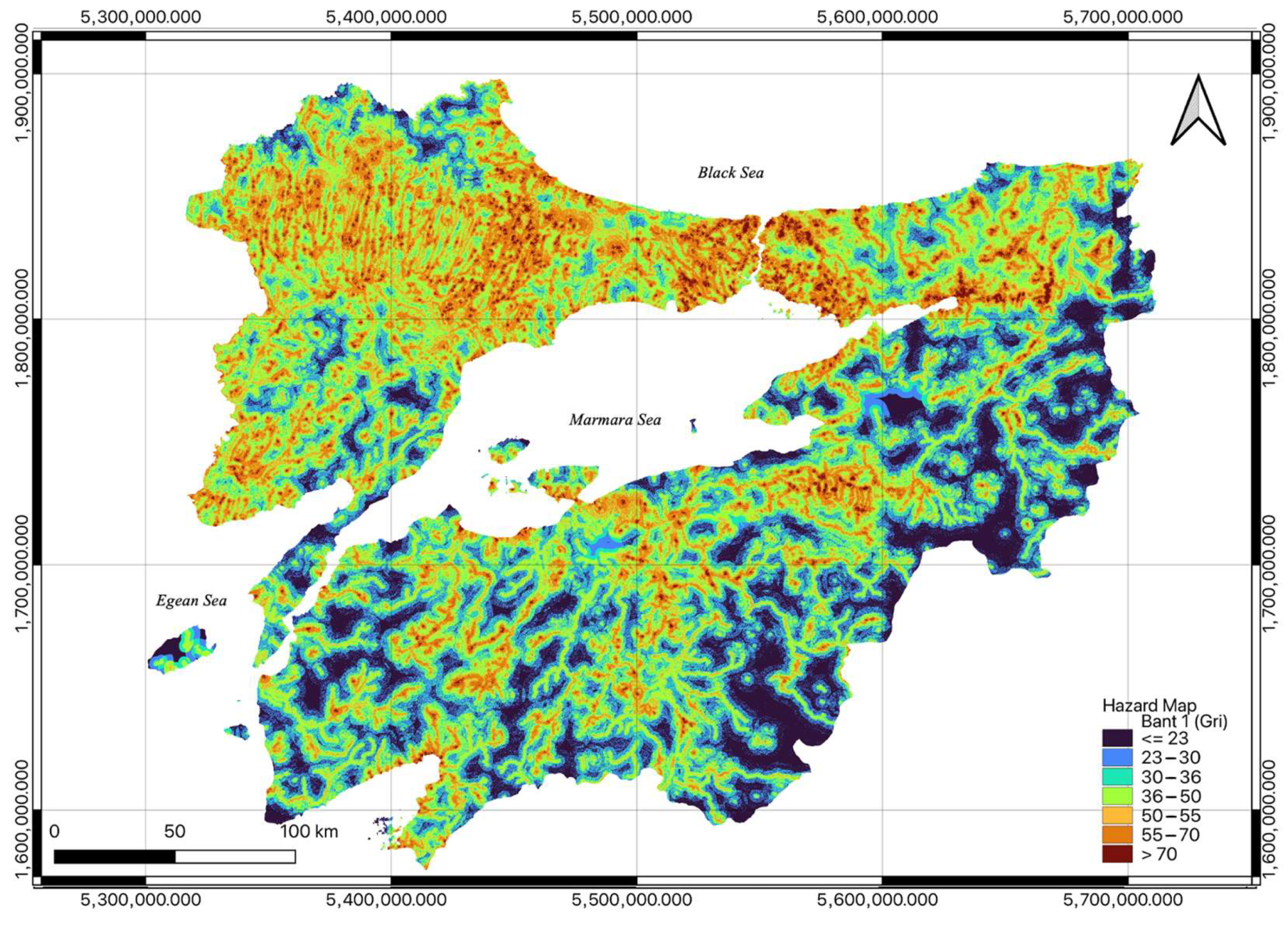
2.3. Flood Hazard Assessment
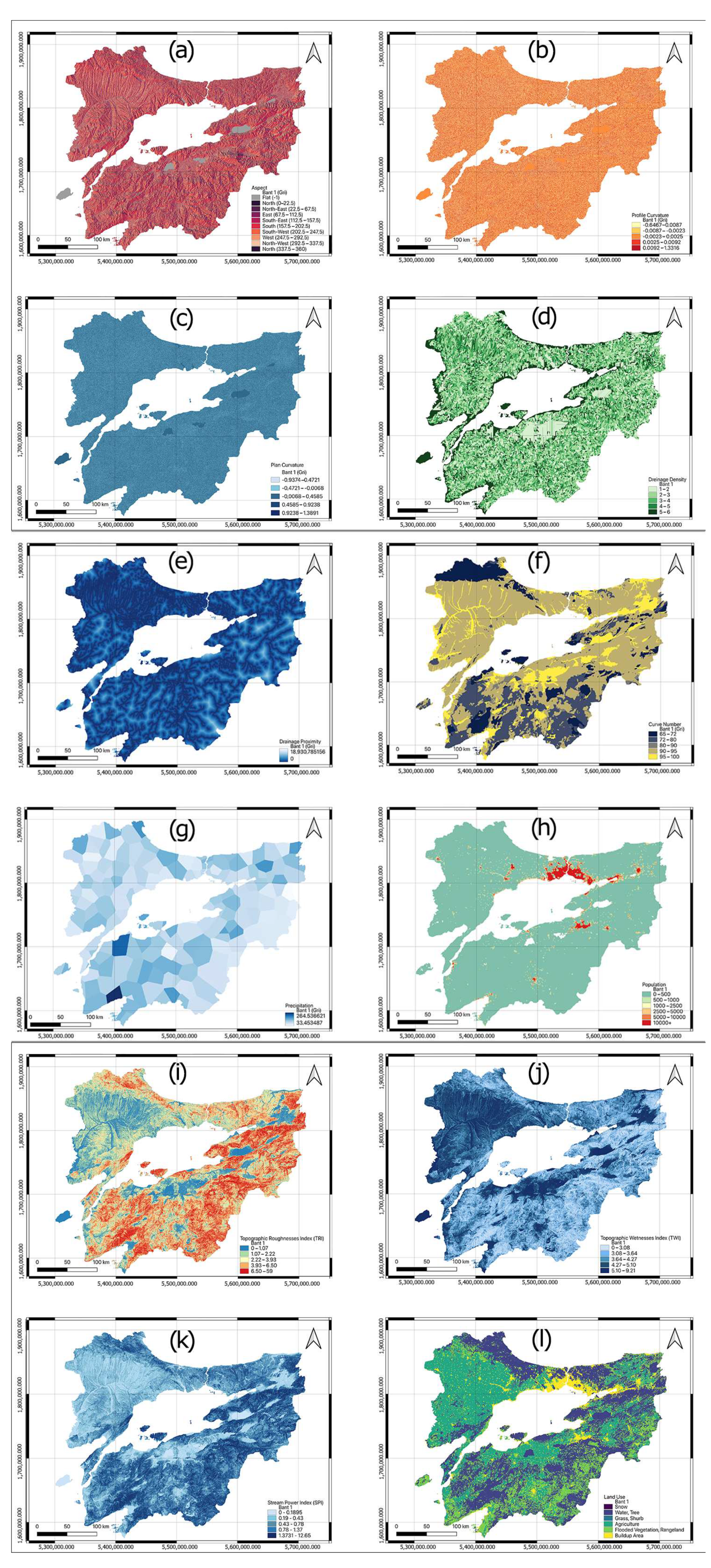
2.4. Flood Vulnerability Assessment
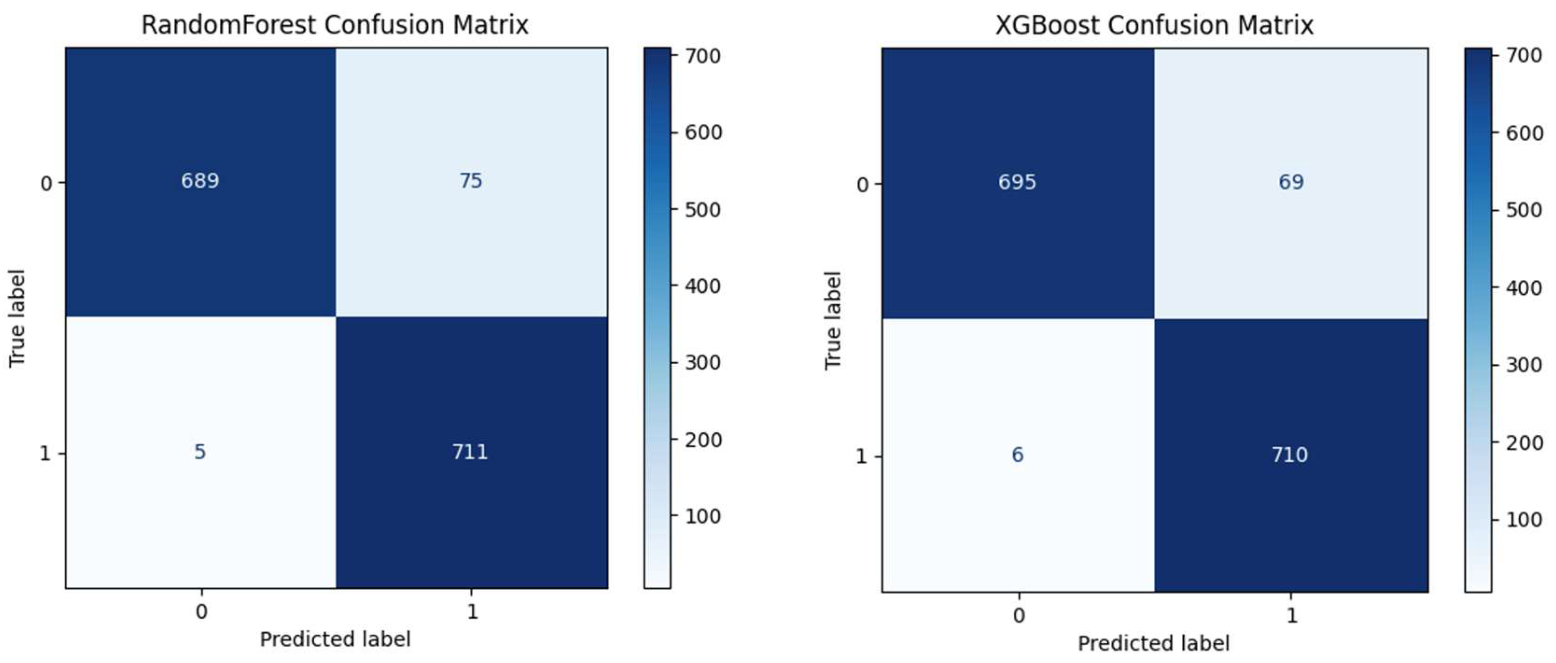
2.5. Vulnerability Model Performance Evaluation
3. Results and Discussion
4. Conclusions
Author Contributions
Funding
Data Availability Statement
Conflicts of Interest
References
- FEMA Federal Emergency Management Agency (FEMA). Guide for All-Hazard Emergency Operations Planning. State and Local Guide (SLG) 101. Available online: https://www.fema.gov/pdf/plan/glo.pdf (accessed on 27 October 2025).
- UNDRR United Nations Office for Disaster Risk Reduction (UNDRR). The Sendai Framework Terminology on Disaster Risk Reduction. “Disaster”. Available online: https://www.undrr.org/terminology/disaster (accessed on 27 October 2025).
- Khantong, S.; Sharif, M.N.A.; Mahmood, A.K. An Ontology for Sharing and Managing Information in Disaster Response: An Illustrative Case Study of Flood Evacuation. Int. Rev. Appl. Sci. Eng. 2020, 11, 22–33. [Google Scholar] [CrossRef]
- Samela, C.; Manfreda, S.; Paola, F.D.; Giugni, M.; Sole, A.; Fiorentino, M. DEM-Based Approaches for the Delineation of Flood-Prone Areas in an Ungauged Basin in Africa. J. Hydrol. Eng. 2016, 21, 06015010. [Google Scholar] [CrossRef]
- Akyel, R. Disaster Management in Turkish Public Administration. Çukurova Üniversitesi Sos. Bilim. Enstitüsü Derg. 2005, 14, 15–29. [Google Scholar]
- Erkal, T.; Değerliyurt, M. Disaster Management in Turkey. East. Geogr. Rev. 2009, 14, 147–164. [Google Scholar]
- Dölek, İ. Identification of the Areas Susceptible to Flooding and Overflows in Sungu and its Surrounding (Muş). Marmara Coğrafya Derg. 2015, 31, 258–280. [Google Scholar] [CrossRef]
- Adnan, M.S.G.; Abdullah, A.Y.M.; Dewan, A.; Hall, J.W. The Effects of Changing Land Use and Flood Hazard on Poverty in Coastal Bangladesh. Land Use Policy 2020, 99, 104868. [Google Scholar] [CrossRef]
- Batur, E.; Maktav, D. Floodplain Assessment with the Integration of Remote Sensing and GIS: Meric River Case Study. Havacılık Ve Uzay Teknol. Derg. 2012, 5, 47–54. [Google Scholar]
- Utlu, M. Flood Hazard Analysis Based on Different Resolution Data Resources: A Case of Biga River Basin. Ph.D. Thesis, İstanbul University, İstanbul, Türkiye, 2019. [Google Scholar]
- El Bilali, A.; Taleb, A.; Boutahri, I. Application of HEC-RAS and HEC-LifeSim Models for Flood Risk Assessment. J. Appl. Water Eng. Res. 2021, 9, 336–351. [Google Scholar] [CrossRef]
- TURKSTAT. Population Projections, 2023–2100. Available online: https://data.tuik.gov.tr/Bulten/Index?p=Nufus-Projeksiyonlari-2023-2100-53699 (accessed on 29 October 2025).
- Kömüşçü, Ü.A.; Çelik, S.; Ceylan, A. Rainfall analysis of the flood event that occurred in Marmara Region on 8–12 September 2009. CBD 2011, 9, 209–220. [Google Scholar] [CrossRef]
- Bandrova, T.; Zlatanova, S.; Konecny, M. Three-Dimensional Maps for Disaster Management. ISPRS Ann. Photogramm. Remote Sens. Spat. Inf. Sci. 2012, I-4, 245–250. [Google Scholar] [CrossRef]
- Bozkurt, Ö.; Çiçekdağı, H.İ. Criteria Prioritization with the Best-Worst Method (BWM) in Risk Reduction Investments after the Provincial Disaster Risk Reduction Plans (IRAP). Afet Ve Risk Derg. 2022, 5, 109–121. [Google Scholar] [CrossRef]
- Dayanır, H.; Çınar, A.K.; Akgün, Y.; Çorumluoğlu, Ö. Post-Disaster Temporary Shelter Area Selection and Planning by Using Delphi Method: Izmir/Seferihisar Case. Doğ Afet Çev Derg 2022, 8, 87–102. [Google Scholar] [CrossRef]
- Ergünay, O. Natural Disasters and Sustainable Development; Abant İzzet Baysal Üniversitesi: Bolu, Türkiye, 2009. [Google Scholar]
- Fan, Y.; Wen, Q.; Wang, W.; Wang, P.; Li, L.; Zhang, P. Quantifying Disaster Physical Damage Using Remote Sensing Data—A Technical Work Flow and Case Study of the 2014 Ludian Earthquake in China. Int. J. Disaster Risk Sci. 2017, 8, 471–488. [Google Scholar] [CrossRef]
- Koçkan, Ç. Natural Disaster Risk Management; Dokuz Eylül Üniversitesi: İzmir, Türkiye, 2015. [Google Scholar]
- Ocak, F.; Bahadir, M. Creating the Sample Flood Risk Model and Flood Risk Analysis of Rivers in Unye. J. Acad. Soc. Sci. Stud. 2020, 13, 499–524. [Google Scholar] [CrossRef]
- Yildirim, R.E. Development of a semi-dynamic flood prediction model based on geographic information systems. Ph.D. Thesis, Ondokuz Mayıs University, Samsun, Türkiye, 2023. [Google Scholar]
- Saaty, T.L. The Analytic Hierarchy Process; McGraw-Hill: Columbus, OH, USA, 1980. [Google Scholar]
- Wang, Y.-M.; Liu, J.; Elhag, T.M.S. An Integrated AHP–DEA Methodology for Bridge Risk Assessment. Comput. Ind. Eng. 2008, 54, 513–525. [Google Scholar] [CrossRef]
- Saaty, T.L. Decision Making—The Analytic Hierarchy and Network Processes (AHP/ANP). J. Syst. Sci. Syst. Eng. 2004, 13, 1–35. [Google Scholar] [CrossRef]
- Hajkowicz, S.; Collins, K. A Review of Multiple Criteria Analysis for Water Resource Planning and Management. Water Resour. Manag. 2007, 21, 1553–1566. [Google Scholar] [CrossRef]
- Ekmekcioğlu, Ö.; Koc, K.; Özger, M. District Based Flood Risk Assessment in Istanbul Using Fuzzy Analytical Hierarchy Process. Stoch. Environ. Res. Risk Assess. 2021, 35, 617–637. [Google Scholar] [CrossRef]
- Breiman, L. Random Forests. Mach. Learn. 2001, 45, 5–32. [Google Scholar] [CrossRef]
- Liaw, A.; Wiener, M. Classification and Regression by randomForest. R News 2002, 2/3, 18–22. [Google Scholar]
- Chen, T.; Guestrin, C. XGBoost: A Scalable Tree Boosting System. In Proceedings of the 22nd ACM SIGKDD International Conference on Knowledge Discovery and Data Mining, San Francisco, CA, USA, 13–17 August 2016; Association for Computing Machinery: New York, NY, USA, 2016; pp. 785–794. [Google Scholar]
- Lundberg, S.M.; Lee, S.-I. A Unified Approach to Interpreting Model Predictions. In Proceedings of the 31st International Conference on Neural Information Processing Systems, Long Beach, CA, USA, 4–9 December 2017; Curran Associates Inc.: Red Hook, NY, USA, 2017; pp. 4768–4777. [Google Scholar]
- Mete, M.O.; Yomralioglu, T. A Hybrid Approach for Mass Valuation of Residential Properties Through Geographic Information Systems and Machine Learning Integration. Geogr. Anal. 2023, 55, 535–559. [Google Scholar] [CrossRef]
- Koyuncu, Z.; Ekmekcioğlu, Ö. Generating the Flood Susceptibility Map for Istanbul with GIS-Based Machine Learning Algorithms. Doğ Afet Çev Derg 2024, 10, 1–15. [Google Scholar] [CrossRef]
- Hammami, S.; Zouhri, L.; Souissi, D.; Souei, A.; Zghibi, A.; Marzougui, A.; Dlala, M. Application of the GIS Based Multi-Criteria Decision Analysis and Analytical Hierarchy Process (AHP) in the Flood Susceptibility Mapping (Tunisia). Arab. J. Geosci. 2019, 12, 653. [Google Scholar] [CrossRef]
- Saaty, T.L. How to Make a Decision: The Analytic Hierarchy Process. Eur. J. Oper. Res. 1990, 48, 9–26. [Google Scholar] [CrossRef]
- Wisner, B.; Blaikie, P.; Cannon, T.; Davis, I. At Risk: Natural Hazards, People’s Vulnerability and Disasters, 2nd ed.; Routledge: London, UK, 2003; ISBN 978-0-203-71477-5. [Google Scholar]
- Masood, M.; Takeuchi, K. Assessment of Flood Hazard, Vulnerability and Risk of Mid-Eastern Dhaka Using DEM and 1D Hydrodynamic Model. Nat. Hazards 2012, 61, 757–770. [Google Scholar] [CrossRef]
- Dandapat, K.; Panda, G.K. Flood Vulnerability Analysis and Risk Assessment Using Analytical Hierarchy Process. Model. Earth Syst. Environ. 2017, 3, 1627–1646. [Google Scholar] [CrossRef]
- Chakraborty, S.; Mukhopadhyay, S. Assessing Flood Risk Using Analytical Hierarchy Process (AHP) and Geographical Information System (GIS): Application in Coochbehar District of West Bengal, India. Nat. Hazards 2019, 99, 247–274. [Google Scholar] [CrossRef]
- Koczkodaj, W.W.; Magnot, J.-P.; Mazurek, J.; Peters, J.F.; Rakhshani, H.; Soltys, M.; Strzałka, D.; Szybowski, J.; Tozzi, A. On Normalization of Inconsistency Indicators in Pairwise Comparisons. Int. J. Approx. Reason. 2017, 86, 73–79. [Google Scholar] [CrossRef]
- Ishizaka, A.; Labib, A. Analytic Hierarchy Process and Expert Choice: Benefits and Limitations. OR Insight 2009, 22, 201–220. [Google Scholar] [CrossRef]
- Malczewski, J.; Rinner, C. Multicriteria Decision Analysis in Geographic Information Science. In Advances in Geographic Information Science; Springer: Berlin/Heidelberg, Germany, 2015; ISBN 978-3-540-74756-7. [Google Scholar]
- Abedi, R.; Costache, R.; Shafizadeh-Moghadam, H.; Pham, Q.B. Flash-Flood Susceptibility Mapping Based on XGBoost, Random Forest and Boosted Regression Trees. Geocarto. Int. 2022, 37, 5479–5496. [Google Scholar] [CrossRef]
- Luu, C.; Tran, H.X.; Pham, B.T.; Al-Ansari, N.; Tran, T.Q.; Duong, N.Q.; Dao, N.H.; Nguyen, L.P.; Nguyen, H.D.; Thu Ta, H.; et al. Framework of Spatial Flood Risk Assessment for a Case Study in Quang Binh Province, Vietnam. Sustainability 2020, 12, 3058. [Google Scholar] [CrossRef]
- Bui, Q.D.; Luu, C.; Mai, S.H.; Ha, H.T.; Ta, H.T.; Pham, B.T. Flood Risk Mapping and Analysis Using an Integrated Framework of Machine Learning Models and Analytic Hierarchy Process. Risk Anal. 2023, 43, 1478–1495. [Google Scholar] [CrossRef]




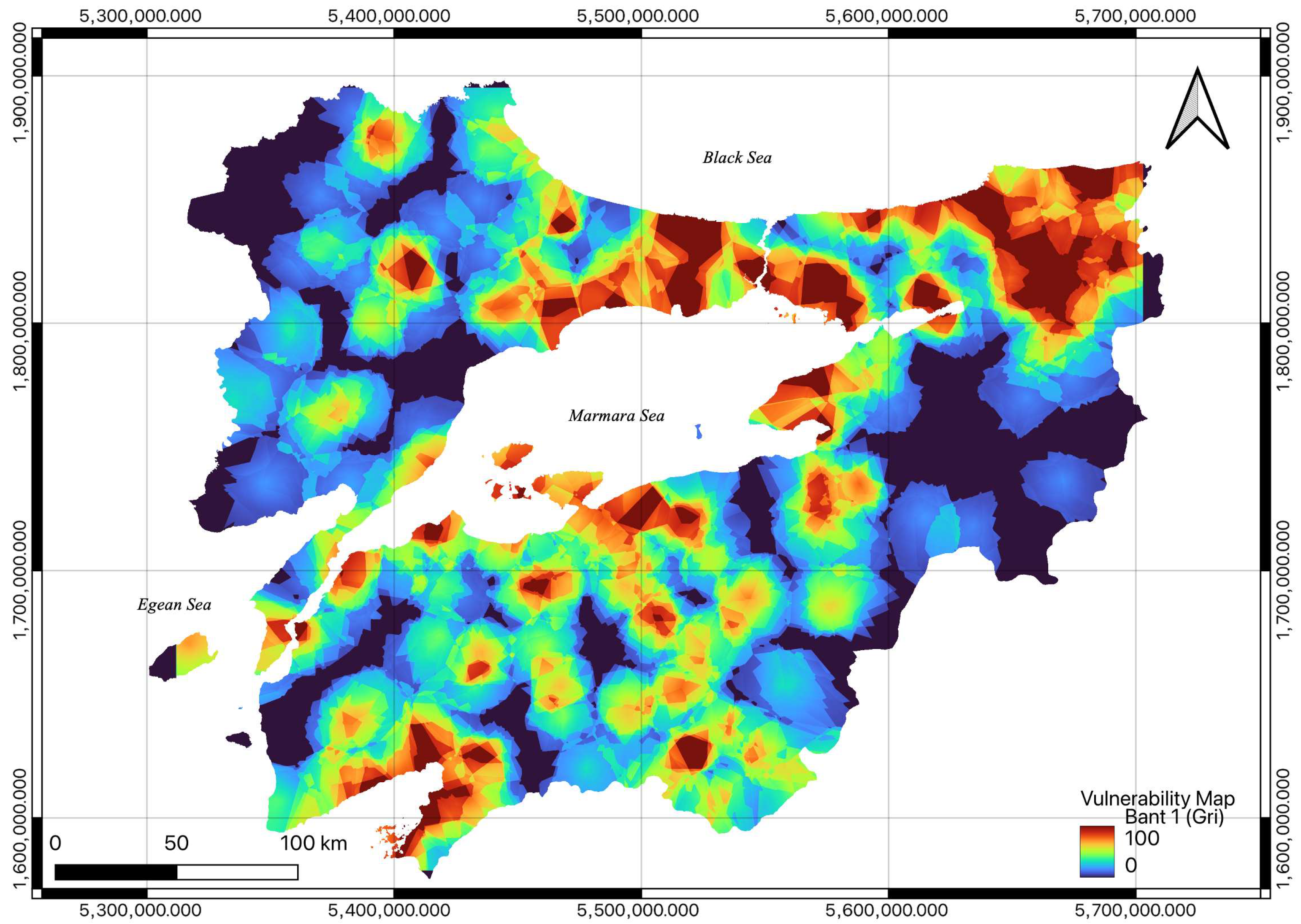
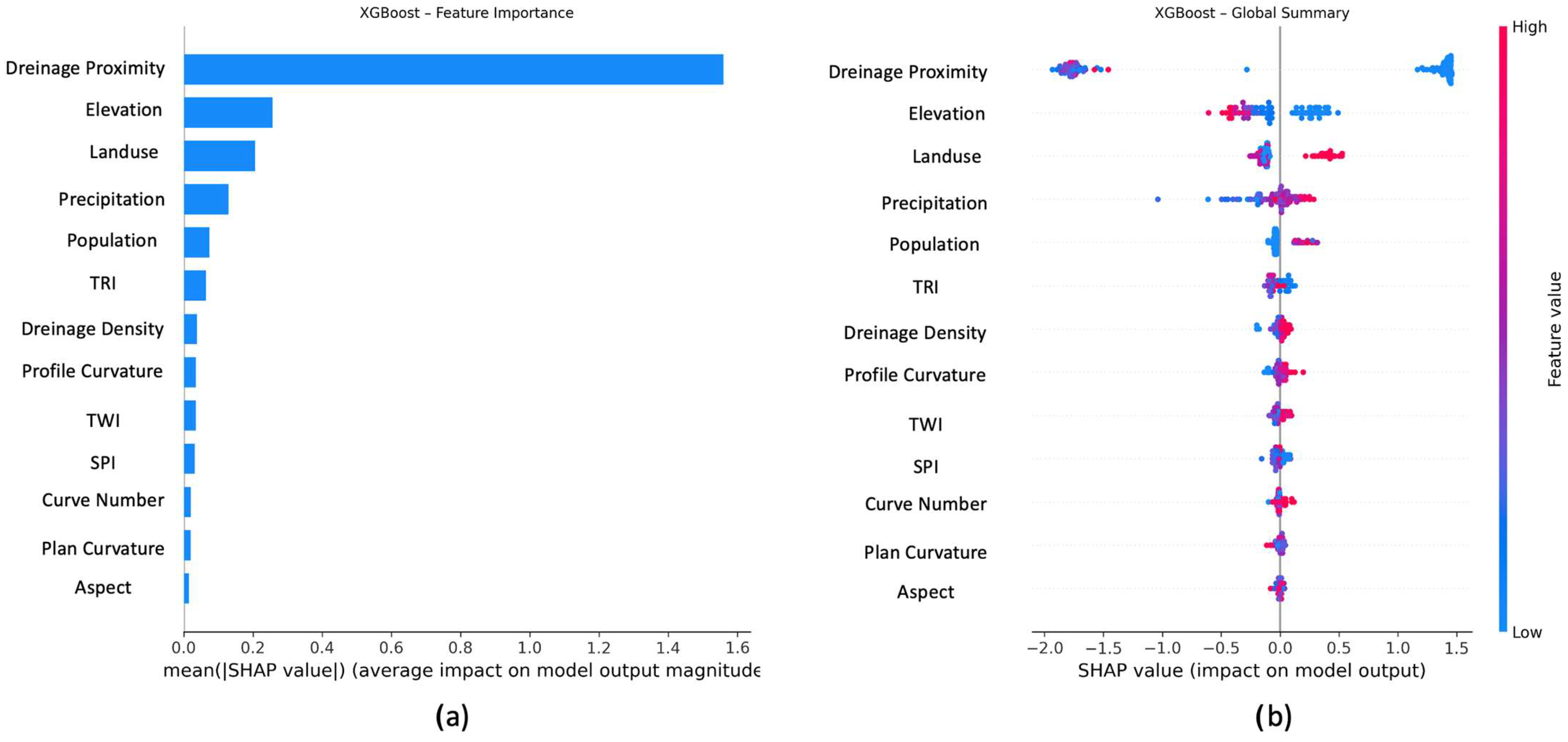
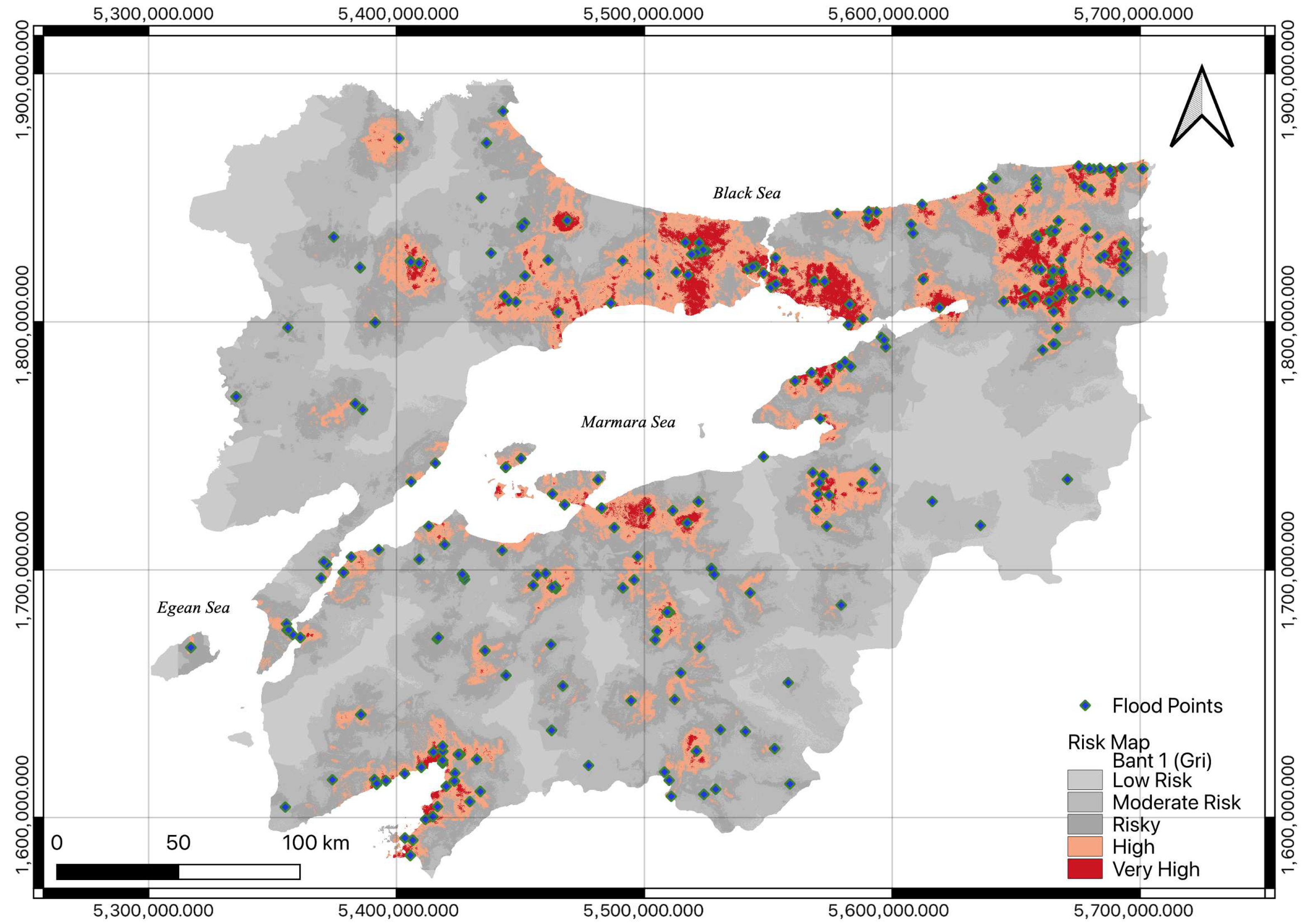
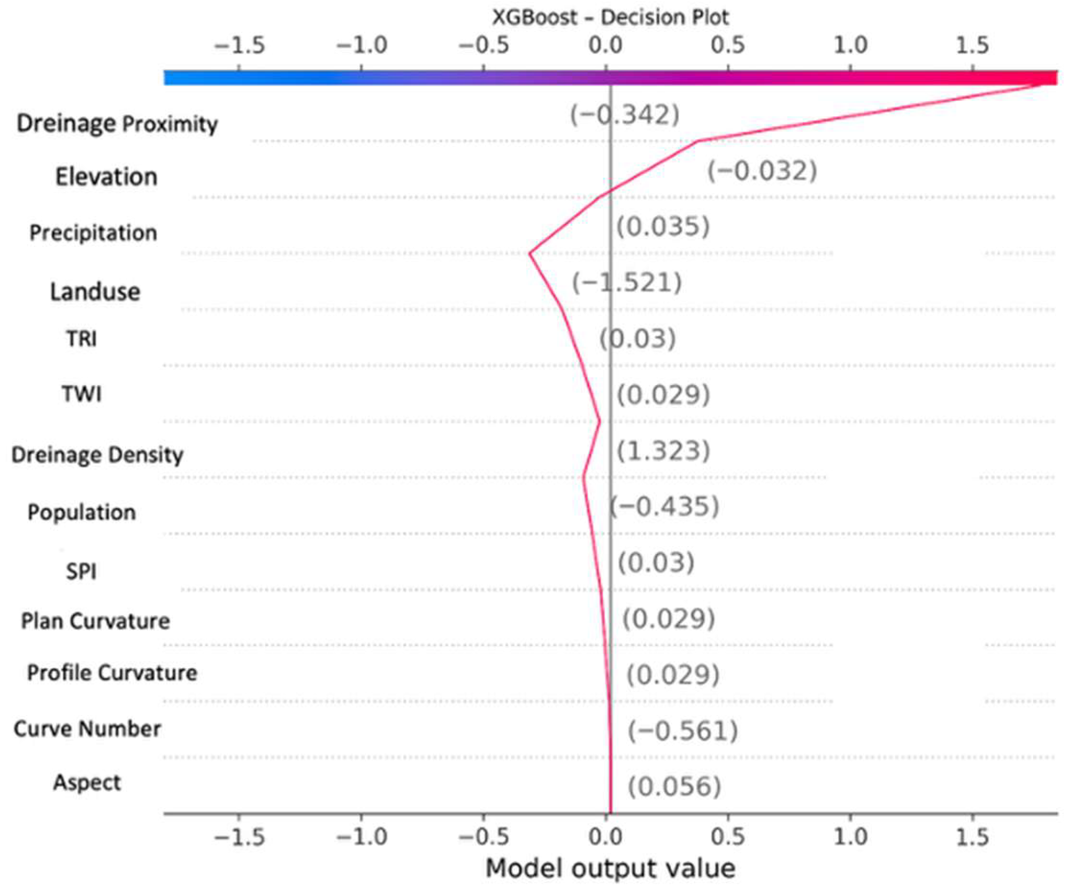
| ID | Factor | Data Source | Evaluation |
|---|---|---|---|
| 1 | Slope | USGS | Hazard |
| 2 | Aspect | USGS | Hazard |
| 3 | Elevation | USGS | Hazard |
| 4 | Flow Direction | USGS | Hazard |
| 5 | Flow Accumulation | USGS | Hazard |
| 6 | Waterways Proximity | OvertureMaps | Hazard |
| 7 | Waterbodies Proximity | OvertureMaps | Hazard |
| 8 | Elevation | USGS | Hazard |
| 9 | Aspect | USGS | Vulnerability |
| 10 | Plan Curvature | USGS | Vulnerability |
| 11 | Profile Curvature | USGS | Vulnerability |
| 12 | Drainage Density | USGS | Vulnerability |
| 13 | Drainage Proximity | USGS | Vulnerability |
| 14 | Curve Number | USGS | Vulnerability |
| 15 | Precipitation | MGM | Vulnerability |
| 16 | Topographic Wetness Index (TWI) | USGS | Vulnerability |
| 17 | Topographic Rugged Index (TRI) | USGS | Vulnerability |
| 18 | Stream Power Index (SPI) | USGS | Vulnerability |
| 19 | Population | TUIK | Vulnerability |
| 20 | Land Use | ESRI | Vulnerability |
| 21 | Flood Impact | DSİ | Vulnerability |
| Criteria | C1 | C2 | C3 | C4 | C5 | C6 | C7 | C8 |
|---|---|---|---|---|---|---|---|---|
| C1 | 1 | 3 | 1/3 | 1/5 | 1/5 | 1/7 | 1/7 | 1/5 |
| C2 | 1/3 | 1 | 1/3 | 1/7 | 1/7 | 1/9 | 1/9 | 1/7 |
| C3 | 3 | 5 | 1 | 1/3 | 1/3 | 1/5 | 1/5 | 1/3 |
| C4 | 5 | 7 | 3 | 1 | 1/3 | 1/5 | 1/5 | 1/3 |
| C5 | 5 | 7 | 3 | 3 | 1 | 1/3 | 1/3 | 1/3 |
| C6 | 7 | 9 | 5 | 5 | 3 | 1 | 1/3 | 3 |
| C7 | 7 | 9 | 5 | 5 | 3 | 3 | 1 | 3 |
| C8 | 5 | 7 | 3 | 3 | 3 | 1/3 | 1/3 | 1 |
| Criteria | C1 | C2 | C3 | C4 | C5 | C6 | C7 | C8 | Weight (Wi) |
|---|---|---|---|---|---|---|---|---|---|
| C1 | 0.0303 | 0.0625 | 0.0161 | 0.0113 | 0.0182 | 0.0268 | 0.0400 | 0.0299 | 0.0303 |
| C2 | 0.0101 | 0.0208 | 0.0161 | 0.0081 | 0.0130 | 0.0209 | 0.0120 | 0.0133 | 0.0185 |
| C3 | 0.0909 | 0.1042 | 0.0484 | 0.0189 | 0.0303 | 0.0376 | 0.0400 | 0.0566 | 0.0556 |
| C4 | 0.1515 | 0.1458 | 0.1452 | 0.0566 | 0.0303 | 0.0376 | 0.0400 | 0.0566 | 0.0851 |
| C5 | 0.1515 | 0.1458 | 0.1452 | 0.1697 | 0.1256 | 0.0376 | 0.1200 | 0.0566 | 0.1162 |
| C6 | 0.2121 | 0.1875 | 0.2419 | 0.2829 | 0.3769 | 0.1256 | 0.1200 | 0.3399 | 0.2335 |
| C7 | 0.2121 | 0.1875 | 0.2419 | 0.2829 | 0.3769 | 0.3769 | 0.3600 | 0.3399 | 0.3119 |
| C8 | 0.1515 | 0.1458 | 0.1452 | 0.1697 | 0.1256 | 0.0268 | 0.1200 | 0.1057 | 0.1489 |
| ML Model | Accuracy | Precision | Recall | F1 Score | AUC |
|---|---|---|---|---|---|
| Random Forest | 0.9459 | 0.9046 | 0.9930 | 0.9467 | 0.9747 |
| XGBoost | 0.9493 | 0.9114 | 0.9916 | 0.9498 | 0.9780 |
Disclaimer/Publisher’s Note: The statements, opinions and data contained in all publications are solely those of the individual author(s) and contributor(s) and not of MDPI and/or the editor(s). MDPI and/or the editor(s) disclaim responsibility for any injury to people or property resulting from any ideas, methods, instructions or products referred to in the content. |
© 2025 by the authors. Licensee MDPI, Basel, Switzerland. This article is an open access article distributed under the terms and conditions of the Creative Commons Attribution (CC BY) license (https://creativecommons.org/licenses/by/4.0/).
Share and Cite
Derman, M.T.; Mete, M.O. Flood Risk Analysis with Explainable Geospatial Artificial Intelligence (GeoAI) Techniques. Systems 2025, 13, 1007. https://doi.org/10.3390/systems13111007
Derman MT, Mete MO. Flood Risk Analysis with Explainable Geospatial Artificial Intelligence (GeoAI) Techniques. Systems. 2025; 13(11):1007. https://doi.org/10.3390/systems13111007
Chicago/Turabian StyleDerman, Mirac Taha, and Muhammed Oguzhan Mete. 2025. "Flood Risk Analysis with Explainable Geospatial Artificial Intelligence (GeoAI) Techniques" Systems 13, no. 11: 1007. https://doi.org/10.3390/systems13111007
APA StyleDerman, M. T., & Mete, M. O. (2025). Flood Risk Analysis with Explainable Geospatial Artificial Intelligence (GeoAI) Techniques. Systems, 13(11), 1007. https://doi.org/10.3390/systems13111007


