Article

Ramp Spacing Evaluation of Expressway Based on Entropy-Weighted TOPSIS Estimation Method

School of Transportation, Southeast University, Nanjing 211189, China
*
Author to whom correspondence should be addressed.
Systems 2023, 11(3), 139; https://doi.org/10.3390/systems11030139
Submission received: 12 February 2023 / Revised: 28 February 2023 / Accepted: 2 March 2023 / Published: 4 March 2023
(This article belongs to the Special Issue Decision Making and Policy Analysis in Transportation Planning)

Abstract

:
The main objective of this study is to design a method for evaluating the reasonability of ramp spacing of the expressway in a specific district. The study proposes an entropy-weighted Technique for Order Preference by Similarity to an Ideal Solution (TOPSIS) estimation method, in which the entropy weight method determines the indicator weights, and TOPSIS is employed to compare different alternatives of ramp spacing. Four patterns of evaluation indicators are taken into account representing traffic efficiency, safety, traffic accessibility, and economy, respectively. Using the Beijing–Hong Kong–Macao Expressway in Henan Province as a case study, the validity of the method is verified, and the optimal ramp spacing is obtained as 14 km for the given scenario. The results of the study show: (1) extreme spacing values are not conducive to the overall benefits of the expressway; (2) ramp spacing settings that allow for coordinated sharing of traffic demand along the route (TDAR) are a prerequisite for an expressway to have great overall benefits; and (3) appropriately shortening ramp spacing will allow the expressway to effectively respond to increased TDAR. The estimation method proposed in this study provides a theoretical reference for the local authority to plan ramp spacing that can satisfy regional traffic demand and ensure the overall benefits of expressways in a sustainable urban context.

1. Introduction

As the national transport corridor connecting large centers of activity over long-haul transportation, expressways play a pivotal role in the entire highway transportation system, which is crucial to ensuring robust economic growth and sustainable development [1,2,3]. In the wake of continuously expanding urbanization, travelers per se have higher requirements for service quality and traffic efficiency [4]. Once travelers select to use an expressway service, they need to enter or exit from ramps along the expressways. That is to say, the placement of ramps and associated spacing has a sizeable influence on the convenience of travelers with exits and entrances regarding the expressway service [5]. When ramp spacing is set to be shorter, traffic accessibility will be improved as travelers can more easily enter/exit the expressway. On the other hands, shorter ramp spacing means more ramps being constructed per unit length of the expressway, which results in some negative impacts. For example, the increase in the number of weaving areas formed by vehicles entering and exiting the ramps causes more frequent disruptions to the traffic flow on the expressway and even brings about safety concerns [6,7]; further, the project cost of constructing more ramps increases concomitantly. Thus, a methodology is necessitated to evaluate the reasonability of different ramp spacing settings, which is addressed in this paper.
Currently, a number of previous studies have been conducted to analyze the reasonable setting of expressway ramp spacing from different perspectives. From the perspective of traffic safety, studies based on accident data near ramps quantified the direct relationship between ramp spacing and safety [8,9,10]. Le and Porter indicate that vehicle crashes increase with the decreasing ramp spacing [11]. For such traffic safety concerns, some existing standards specify the minimum ramp spacing pertaining to geometric design variables concerning weaving volume, ability to sign, and lengths of speed-change lanes. For instance, the American Association of State Highway and Transportation Officials (AASHTO) specifies a minimum ramp spacing of 3 km in rural areas [12]; the specification developed by the China Highway Engineering Consultants Corporation recommends that the spacing between adjacent ramps should be at least 4 km [13]. Further, some studies investigated ramp spacing from the perspective of traffic efficiency. The Highway Capacity Manual 2010 manifests that ramp spacing is related to vehicle speed [14]. Several scholars consider the setting of ramp spacing by analyzing vehicle operating characteristics along the expressway. For instance, Chen et al. calculated reasonable ramp spacing by applying a statistical package for the social sciences and multiple linear regressions to analyze the speed characteristics within an expressway section [15]. Wang et al. determined the ultimate expressway ramp spacing based on constructing the GPS floating car speed data-driven model and the gap acceptance model [16]. Using acceleration noise to represent the stability of traffic conditions, Jang reported the minimum ramp spacing under higher-speed traffic conditions (around 160 km/h) [17]. To compensate for the lack of acceleration noise’s discrimination between index per minimum spacing, Kim et al. utilized the surrogate safety assessment model to analyze conflicts and estimated the minimum ramp spacing for expressways that allow travel speed above 140 km/h [18]. Moreover, the issue of economic factors is also taken into account in determining ramp spacing, as the construction cost of ramps is expensive in the expressway system [19]. According to surveys of ramp construction costs [20,21], a ramp’s (a complete structure including at least one entrance and one exit) cost can range from USD 5 million to USD 15 million or more when the mainline of an expressway costs range from USD 7 million to USD 15 million per kilometer to build. Therefore, ramp spacing being set excessively short unnecessarily increases the overall project cost. Ramp spacing that considers the economic factors is conducive to guaranteeing the successful construction of the expressway project and enhancing social benefits [22].
Most previous studies about ramp spacing focused on the setting of minimum spacing considering one or two indicators (e.g., safety, economy). However, these studies did not compare the effects of different ramp spacing settings, while lacking consideration of more factors reflecting practical circumstances. For example, Winkler and Fan indicated that when ramp spacing is set longer, there are fewer weaving areas along the expressway, which contributes to increased expressway capacity, improved safety, and lower construction costs [23]. However, Chen et al. point out that excessively long ramp spacing poses an inconvenience as travelers have to travel long distances to the nearest ramp [24]; it can also reduce travelers’ motivation to choose the expressway and wastes road resources, because travelers prefer to enter the expressway at the on-ramp closest to their origin and exit at the off-ramp closest to their destination. Hence, the setting of ramp spacing is a nontrivial task, which needs to simultaneously allow for several factors so that the ramps can be set to accommodate the multiple benefits of the expressway, especially in the context of urbanization expansion and rapid land use development around cities.
In practice, the evaluation of expressway ramp spacing involves multi-criteria, and various patterns of relevant indicators need to be taken into account. In recent years, several popular estimation methods of multi-criteria decision making have been developed, such as Analytic Hierarchy Process (AHP), Technique for Order Preference by Similarity to an Ideal Solution (TOPSIS), PROMETHEE, and Fuzzy AHP [25]. Among these, TOPSIS has a relatively simple calculation algorithm, which can analyze quantitative data and fully use data information [26,27]. Recently, a growing number of estimation studies in the field of transportation have applied TOPSIS [28,29,30,31], e.g., quality and safety of public transport, scenarios for developing public transport systems, choice of investment location, and road transport. However, none of the prior studies have particularly applied estimation methods to analyze the effects of ramp spacing settings on the level of expressway service.
To fill such a gap, the objective of this study is to propose an entropy-weighted TOPSIS estimation method that quantitatively estimates different settings of ramp spacing along the expressway within a specific district. The evaluation indicator system contains four patterns of relevant indicators spanning traffic efficiency, safety, traffic accessibility, and economy, respectively. Further, the Beijing–Hong Kong–Macao Expressway within Henan Province in China is applied as the case study to obtain estimation results based on the proposed estimation method. Finally, the evaluation results are analyzed to explore the potential principles for setting the ramp spacing of expressways within specific districts and to provide a theoretical basis for the practical applications. The method proposed in this study takes a long expressway section as a research object for setting ramp spacing from the regional level. Compared with studies that separately consider factors such as vehicle safety [32], traffic demand [33] or operating characteristics [15,16,17,18], respectively, the results of this research have critical theoretical support for setting ramp spacing that satisfies the whole district’s traffic demand and gives the whole expressway system good comprehensive benefits. In addition, it can provide preliminary recommendations for setting ramp spacing for studies that consider multiple factors for ramp siting [24]. In the context of urbanization expansion, this study has implications for promoting the efficient use of road resources and sustainable transportation development.
The remainder of this paper is organized as follows. Section 2 below describes the problem and evaluation indicators. Section 3 introduces the estimation model. Then, a case study is conducted in Section 4, and discussions are presented in Section 5. Finally, conclusions are provided in the last section.

2. Problem Statement and Evaluation Indicators

2.1. Problem Statement

In this paper, we study the setting of ramp spacing along the expressway within a specific district. The expressway in the district attracts demand from enroute cities, counties, and towns. For the sake of simplicity, these demand regions are divided into U towns (denoted as the units of demand) and represented by a set of corresponding centroids T = { T 1 , T 2 , , T U } . Note that all these towns constitute the service area dubbed “study district”. This study proposes m possible alternatives for ramp spacing settings according to the characteristics along the expressway. It is assumed that under each spacing alternative, travelers always choose the closest ramps to their origins or destinations to employ the expressway service. Table 1 depicts the variables used in the evaluation indicator system.

2.2. Evaluation Indicator System

The setting of ramp spacing is of fundamental importance to the sustainability of expressway service, particularly regarding accessibility. Shortening ramp spacing can improve accessibility obviously. However, the shorter spacing requires more ramps to be built and increases the construction cost. Furthermore, excessively short spacing makes the weaving behaviors of vehicles more frequent, which will adversely affect traffic efficiency and operational safety for vehicles when using the expressway service [24]. To determine the appropriate setting of ramp spacing, an evaluation indicator system simultaneously consisting of traffic efficiency, safety, traffic accessibility, and economy needs to be constructed. Evaluation indicators are employed in the estimation method in Section 3.

2.2.1. Traffic Efficiency

Traffic efficiency is characterized by the average speed v ¯ and average delay d ¯ of the vehicles traveling on the expressway section (including mainline and ramps). The meanings of these two indicators are described by Equations (1) and (2), respectively:
v ¯ = i = 1 N v i N ,
d ¯ = i = 1 N t i N ,
where v i is the speed of vehicle i on the expressway section (km/h); d i denotes the delay of vehicle i on the expressway section (s); N represents the sample size of vehicles in the whole process of simulating traffic operation on the expressway section with VISSIM.

2.2.2. Safety

Due to the normal situation of traffic flow being seriously affected once an accident occurs on the expressway, this study chose traffic accident rate as the safety indicator. As per the work of Pei and Cheng [34], the accident rate increases exponentially with the increase in vehicle speed standard deviation. The fitting relationship between accident rate, vehicle speed, and standard deviation of vehicle speed is shown as below:
ϵ = 9.583 exp 0.055 σ ,
where ϵ is the accident rate per 100 million vehicle-kilometers (case/(km∙10−8∙veh−1)); Let σ = i = 1 N ( v i v ¯ ) 2 N 1 , σ denotes the standard deviation of the speed of all vehicles on the expressway section (km/h).

2.2.3. Traffic Accessibility

Traffic accessibility is utilized to estimate the convenience of vehicles accessing the expressway service. It is assumed that traffic accessibility is related to the comprehensive level of service (LOS) of roads within the town and the comprehensive aggregation size (CAS) of the town.
In terms of LOS of the road, different grades of roads are assigned according to the relevant specification for urban road design [35]: expressway = 4, trunk road = 3, secondary road = 2, and slip road = 1. The comprehensive LOS of roads within the town can be calculated as below:
L i = l e n α h α L e n i ( i T ) ,
where l e n α denotes the length of the road with grade α ; h α is the evaluation value of the road with class α ; L e n i signifies the total length of the roads passing through town i .
Then, using the reciprocal of the distance from town i to ramps, the accessibility of town i is calculated as:
a i = j R i L i 1 l i j ( i T ) ,
where R i represents the set of ramps that can serve town i , c a r d ( R i ) is less than the number of ramps in the corresponding spacing alternative; l i j represents the distance from town i to ramp j , j R i .
CAS comprehensively represents the quality and quantity of economic activity aggregation scale within a town [36]. The CAS of a town is generally assessed based on the intensity of development, economic prosperity, scale of land development, and population. The comprehensive aggregation size M i can be expressed by:
M i = k = 1 P γ k u i k u k ( i T ) ,
where P is the number of evaluation indicators about CAS; γ k signifies the weight of the k - th evaluation indicator; u i k is the value of the k - th evaluation indicator of town i .
Finally, the value of the accessibility of the study district equals:
ϕ = i T M i a i ,

2.2.4. Economy

The project cost is selected as the economic efficiency indicator of constructing ramps. Based on the density of ramps along the expressway, the project cost is calculated:
Ω = l c + δ c ρ β c ,
where Ω represents the project cost of constructing all ramps along the expressway section; l c , δ c , and β c are parameters related to the project cost.
Table 2 describes the information of all the indicators employed in the evaluation indicator system.

3. Methodology

To evaluate the effect of different ramp spacing settings, we develop the entropy-weighted TOPSIS estimation method by employing the evaluation indicators in Section 2.2. Based on the weight of each indicator determined by the entropy weight method, TOPSIS is used to compare different alternatives of ramp spacing settings.

3.1. Entropy Weight Method

The entropy weight method, which introduces the idea of information entropy, is an objective weighting method [37]. The method mainly uses the difference degree of indicators to estimate the effective information in the known data and calculate the entropy weight of each indicator. The entropy weight reflects the ability of each evaluation indicator to pass decision information [38,39]. The basic calculation steps of the entropy weight method are as follows:
Step 1: Initial data matrix normalization
It is set that the initial data matrix of the entropy weight evaluation system consists of m evaluation objects and n evaluation indicators,
X = [ x 11 x 12 x 1 n x 21 x 22 x 2 n x m 1 x m 2 x m n ] ,
where x i j ( i = 1 , 2 , , m ; j = 1 , 2 , , n ) denotes the value of the j - t h indicator in the i - t h evaluation object.
In order to eliminate the influence of different indicator units on the evaluation results, each indicator is standardized. The step transformation method is a standardization method used commonly, and the equations are as follows:
x i j = { x i j x j min x j max x j min , x j max x j min    1     , x j max = x j min ( applicable   benefit   indicators ) ,
x i j = { x j max x i j x j max x j min , x j max x j min    1     , x j max = x j min   ( applicable   cos t   indicators ) .
Step 2: Estimating the proportion p i j of x i j of the i - t h evaluation object for the j - t h indicator
p i j = x i j / i m x i j ( j = 1 , 2 , , n ) ,
Step 3: Calculating the value of the information entropy e j of the j - t h indicator
e j = k i = 1 m p i j ln p i j ( j = 1 , 2 , , n ) ,
where k = 1 / ln n , is a non-negative constant related to the number of evaluation objects; when set p i j = 0 , p i j ln p i j = 0 .
Step 4: Calculating the weight of the indicators
The weight w j of the j - t h indicator is calculated by:
w j = 1 e j j = 1 n ( 1 e j ) ( j = 1 , 2 , , n )

3.2. TOPSIS Method

TOPSIS is a comprehensive distance-based evaluation method, first proposed by C. L. Hwang and K. Yoon in 1981 [40]. The method uses the proximity of the evaluation alternative to the idealized target to rank the merits of each evaluation alternative.
In this study, we design m spacing alternatives by varying the value of the ramp spacing and consider them as the evaluation objects of TOPSIS. The five evaluation indicators in Section 2.2 are introduced as criteria in TOPSIS. We express the set of alternatives as A = { A 1 , A 2 , , A m } , and the set of criteria as C = { C 1 , C 2 , , C n } , where n = 5 . The construction process of the entropy-weighted TOPSIS estimation method is shown as follows.
Step 1: Establishing the decision matrix
According to the obtained performance value d i j , we construct the decision matrix D = [ g i j ] m × n for evaluation:
D = C 1 C 2 C n A 1 A 2 A m [ g 11 g 12 g 1 n g 21 g 22 g 2 n g m 1 g m 2 g m n ] ,
where A represents the evaluated alternative and C represents the criterion.
Step 2: Determining the normalization decision matrix
Performance values are normalized to ensure that utility preferences have a consistent unit of measurement while avoiding extreme values affecting similarity distance measurement. A normalized performance value ( z i j ) is calculated as below:
z i j = g i j i = 1 m g i j 2 i , j
The normalization decision matrix is expressed as:
Z = C 1 C 2 C n A 1 A 2 A m [ z 11 z 12 z 1 n z 21 z 22 z 2 n z m 1 z m 2 z m n ]
Step 3: Determining the positive and negative ideal solutions
In the TOPSIS method, the evaluation criteria are divided into benefit criteria and cost criteria. Let the set of benefit criteria be expressed as B , and H denote a set of cost criteria. Z + represents the positive ideal solution (PIS) and Z denotes the negative ideal solution (NIS). According to the Equations (18) and (19), Z + and Z can be calculated:
Z + = ( ( max i z i j j B ) , ( min i z i j j H ) ) = ( ( z j + j = 1 , 2 , , m ) )
Z = ( ( min i z i j j B ) , ( max i z i j j H ) ) = ( ( z j j = 1 , 2 , , m ) )
Step 4: Computing the distance to the ideal solutions
The Euclidean distance from each alternative A i to PIS or NIS can be calculated, respectively, by the following equations:
D i + = j = 1 n w j ( Z j + z i j ) 2 , i = 1 , 2 , , m
D i = j = 1 n w j ( Z j z i j ) 2 , i = 1 , 2 , , m
where D i + is the distance from the alternative A i to PIS; D i signifies the distance from the alternative A i to NIS.
Step 5: Calculating the relative proximity to PIS
The relative proximity ( S i ) of an alternative is expressed as follows:
S i = D i D i + + D i
where 0 S i 1 .
Step 6: Ranking the alternatives
Rank alternatives in descending order according to their proximity value ( S i ). The alternative with larger relative proximity is closer to PIS. At last, the alternative with the highest relative proximity value is considered the most suitable setting of ramp spacing on expressway.

4. Case Study

In this section, we illustrate the applicability of the entropy-weighted TOPSIS estimation method in evaluating and comparing different ramp spacing settings along the expressway. The case study is conducted based upon the Beijing–Hong Kong–Macao Expressway within Henan Province, China.

4.1. Study Area

Henan Province is a provincial administrative region located in central China, which owns one of the most salient transportation hubs. Its population reached 98.83 million by 2021. By the end of 2020, the mileage of expressways in Henan Province reached 7100 km, with 17 national expressway arteries, such as the Beijing–Hong Kong–Macao Expressway, and more than 50 regional expressways.
In this study, we select the Beijing–Hong Kong–Macao Expressway as the object of case study (see Figure 1) as it is an important logistics channel in Henan Province. The total length of the Beijing–Hong Kong–Macao Expressway within Henan Province is 513 km. The overall environment is set based on the alignment of the Beijing–Hong Kong–Macao Expressway (Minggang Toll Station-Lingying Toll Station section in Henan Province), and an expressway with a total length of 175 km is constructed in ArcGIS for the study. The expressway studied subsumes eight lanes in both directions with a lane width of 3.75 m.
According to the highway design specification [41] conforming to the current status quo of road transportation in China: the auxiliary lanes are needed to be designed for too short ramp spacing, and U-turn lanes should be provided for excessively long ramp spacing. To ensure safety and reduce additional construction costs, we take the minimum spacing (4 km) stipulated in the specification as minimal ramp spacing and set maximal ramp spacing to 24 km. On this basis, a total of 21 alternatives of ramp spacing settings are generated, in which the ramp spacing ranges from 4 km to 24 km.
To obtain the data of the evaluation indicators of each alternative, we determine the expressway traffic demand and substitute it into VISSIM for simulation. The traffic demand of the expressway is divided into traffic demand along the route (TDAR) and transit traffic demand (TTD).
The town is set as the study unit, and “location potential” is used to characterize the locational advantage of a town over the standard town. The location potential of the town is calculated based on the OD data of the expressway and the point of interest (POI) data of towns. The steps for estimating the traffic demand of the expressway are shown as follows:
(i) Estimate the traffic demand of towns: using location potential [36], disperse the cross-sectional traffic volume of the toll stations along the expressway to each town;
(ii) Determine the TDAR: on the basis of distance decay theory [42,43], allocate the estimated traffic demand of the towns along the expressway to each ramp reset according to the spacing alternatives;
(iii) Calculate the TTD: the TTD can be obtained by setting the ratio of the TTD.
The Detailed Expressions for Estimating Traffic Demand are Given in Appendix A.

4.2. Results and Discussions

Based upon the entropy-weighted TOPSIS estimation method, the ramp spacing alternatives are evaluated and the ranking results are sequentially obtained. The weights of each indicator calculated using Equations (9)–(14) are shown in Table 3.
In order to discretize the indicator values of the normalization decision matrix in TOPSIS, we replace the normalization decision matrix with the matrix obtained through Equations (9)–(11). Table 4 shows the normalization decision matrix Z .
Since the elements of the obtained decision matrix  Z are all positive values, the positive ideal solution Z + consist of the maximum value of each column element in Z , and the negative ideal solution Z denotes the opposite. They are shown as follows:
Z + = ( C 1 + , C 2 + , , C n + )
Z = ( C 1 , C 2 , , C n )
Thus, PIS and NIS are:
Z + = { 1.00 , 1.00 , 1.00 , 1.00 , 1.00 } Z = { 0.00 , 0.00 , 0.00 , 0.00 , 0.00 }
Based on the normalized Euclidean distance, the distance from PIS or NIS to each alternative is measured. Next, each spacing alternative’s comprehensive score ( C i ) is obtained by calculating the relative proximity. Finally, the alternatives are ranked according to the descending order of C i . Among all the alternatives, A 11 (ramp spacing was 14 km) have the comprehensive score closest to 1 and the best overall effectiveness. Therefore, the optimal alternative of ramp spacing settings for this study is A 11 .

4.2.1. Comparison of Ramp Spacing Alternatives

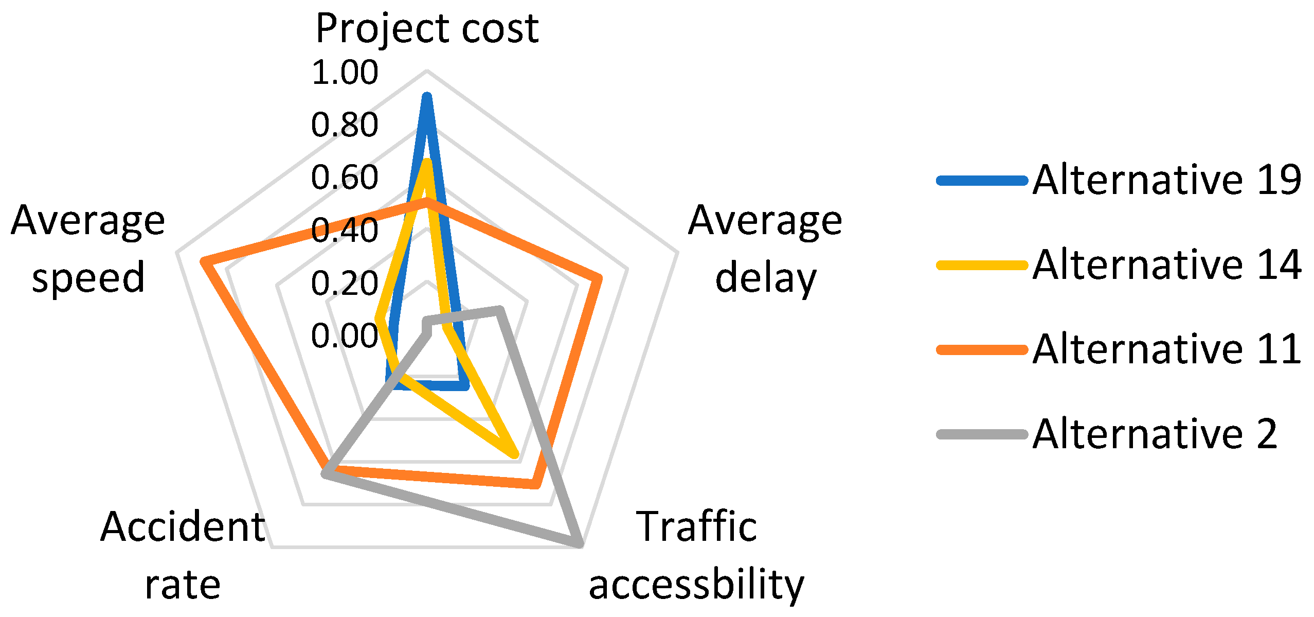
Figure 2 depicts the evaluation indicator values of several representative alternatives as compared to the optimal setting A 11 . The ramp spacing in A 2 and A 19 is close to the left endpoint and right endpoint of the spacing value interval, respectively. A 2 has a great performance in terms of traffic accessibility. However, the setting of the ramps too close leads to more weaving points along the expressway, which is not conducive to vehicle speed and traffic safety. Meanwhile, A 2 is not economical due to the need of building more ramps. These findings are consistent with those of previous studies [9,24]. In contrast, the ramp spacing of A 19 is relatively long. This alternative reduces the project cost and it is not detrimental to traffic efficiency, accessibility, and safety. It can be observed that adjacent ramps are so far apart that traffic entering or leaving the expressway accumulated on the same ramp, causing traffic congestion in merging and diverging areas. Therefore, the two ramp spacing alternatives A 2 and A 19 have relatively low comprehensive scores.
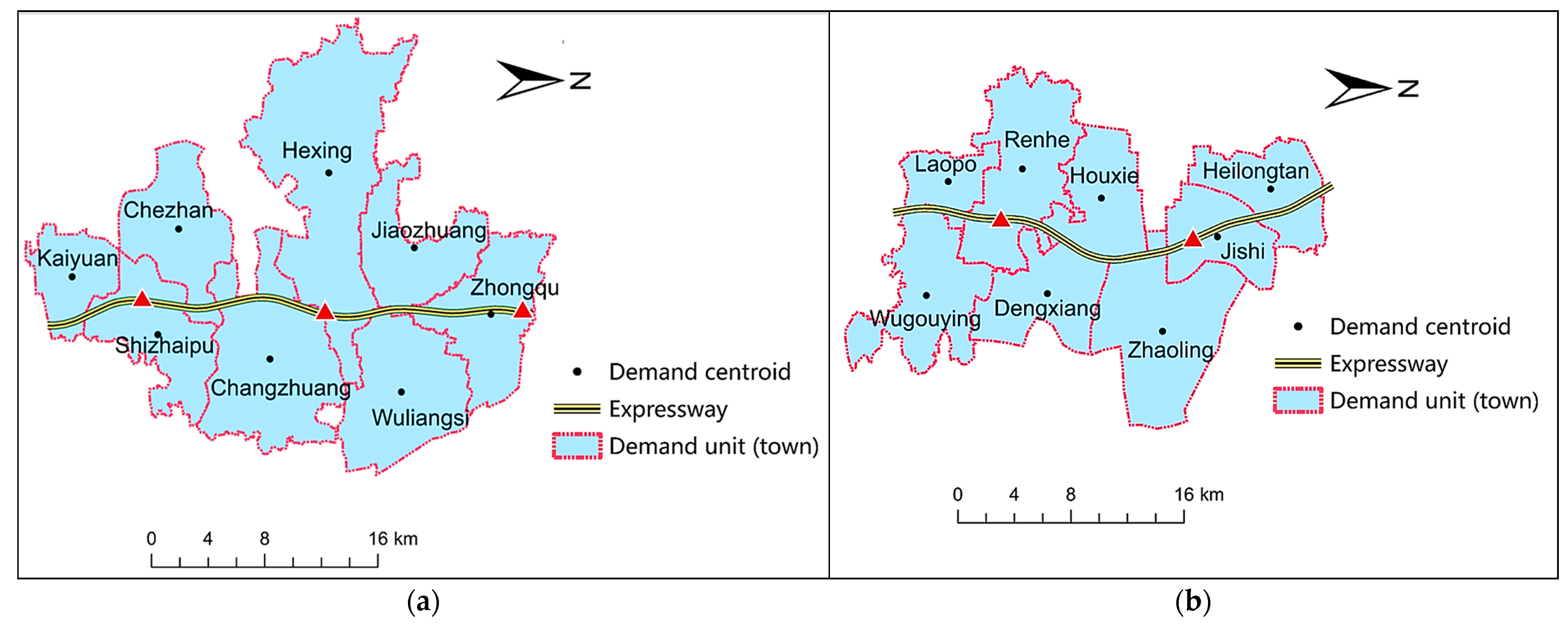
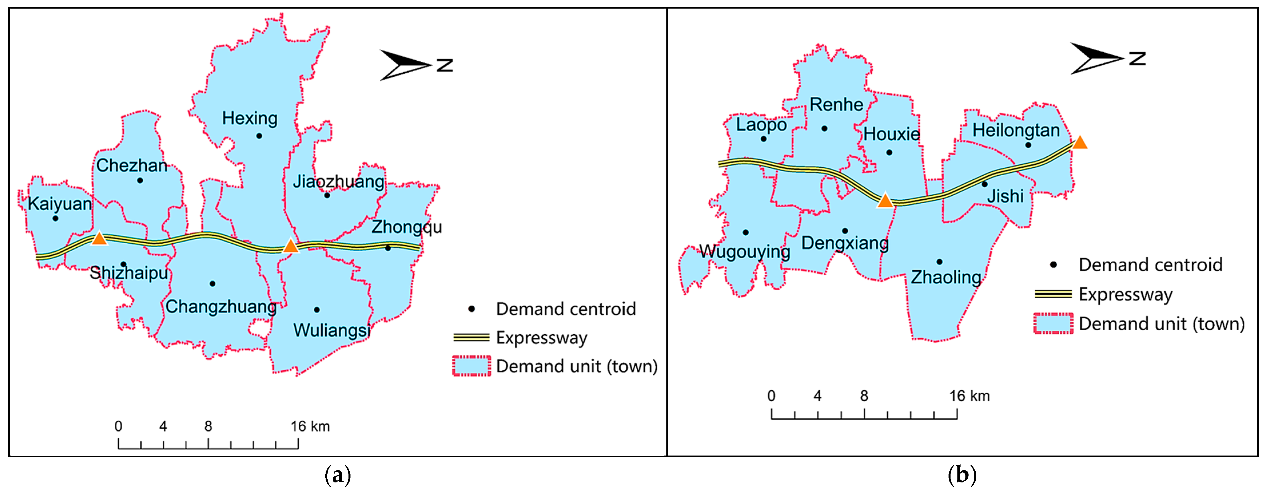
Regarding alternative A 14 , the ramp spacing value is 17 km, which is close to the ramp spacing of the optimal alternative A 11 . However, the comprehensive score of the A 14 (0.358) is apparently lower than that of the optimal alternative (0.663). As can be seen from Figure 2, A 14 is less effective in traffic efficiency and safety. The low comprehensive score of A 14 may be due to the fact that the ramps it provides cannot effectively serve the demand-intensive area. As shown in Figure 3a,b, the density of demand units (towns) distributed along the two expressway sections are about 0.235 and 0.255, respectively, which are both greater than that along the whole studied section (0.177), where these two areas are both demand-intensive areas. In Figure 3a and Figure 4a, the optimal setting A 11 provides three ramps to serve the demand-intensive area I, while A 14 sets only two ramps capable of carrying the traffic demand in the area. Additionally, as Figure 3b and Figure 4b show, both A 11 and A 14 set two ramps to serve the demand-intensive area II. We further compare the distribution of ramps within the demand-intensive area II. On the one hand, ramps provided in A 11 are located in the middle of this area and can effectively partake the traffic demand within the area. On the other hand, one of the ramps established in A 14 is at the edge of the demand-intensive area II; according to the distance decay theory, more traffic demand is concentrated on the other ramp. In conclusion, the location of ramps in alternative A 14 is not adapted to the practical circumstances of traffic demand distribution within the demand-intensive areas, resulting in potential traffic congestion in the merging and diverging areas; thus, ramp spacing alternative A 14 yields relatively lower traffic efficiency and safety.

4.2.2. Sensitivity Analysis of TDARs

In this subsection, we conduct a sensitivity analysis on the effect of TDAR variation on the resulting optimal ramp spacing setting. First, assuming a constant value of TTD, the study scenarios with increased TDAR are simulated using VISSIM. Then, the simulation data of the spacing alternatives are evaluated using the method proposed in this research, and the variation of the optimal ramp spacing value with TDAR is analyzed. Figure 5 shows the heat map of the comprehensive score of spacing alternatives. The horizontal axis represents the average TDAR of the towns along the expressway; the vertical axis is the comprehensive score; the closer the color to blue in the figure indicates a lower score, and conversely, the closer the color to orange. As can be seen from Figure 5, the spacing values corresponding to the alternatives with high scores become shorter as TDAR increases. The reason may be that the traffic flow on the main line is mainly affected by the traffic flow in the weaving area when the ramp spacing is set larger than a specific value. Therefore, when the specific spacing condition is satisfied, adding the number of ramps to disperse the traffic flow entering or exiting the expressway is conductive to mitigating the disturbance of the more complex weaving behavior generated by increased TDAR and improving the overall performance of the expressway.
Overall, this study provides theoretical references and suggestions for the local authority to design appropriate ramp spacing along the expressway: (i) setting the ramp spacing of expressway should comprehensively consider the traffic efficiency, traffic accessibility, safety, and economy. It is not advisable to set the ramp spacing too short so as to improve accessibility, nor too long spacing in an effort to reduce construction costs, which can affect safety negatively. (ii) When setting the ramp spacing of the expressway from the regional level, the ramp spacing of the demand-intensive areas should be adjusted as per the actual demand distribution to improve the service quality of expressways. (iii) The practical implication of the proposed estimation method can indeed improve the practical operations of the expressway service via accommodating local considerations of ramp placement.

5. Conclusions

Expressways are the critical ingredients of the entire highway transportation system, which promotes economic growth and sustainable development. The spacing of ramps, which are the main channels connecting the general road network to the expressway, significantly affects the degree of function and overall efficiency of the expressway. Setting the ramp spacing that ensures the best overall benefits of the expressway is a complex issue that requires consideration of multiple influences.
This paper studies the problem of evaluating the ramp spacing of expressways in a specific district. The purpose is to propose a method that can comprehensively evaluate the ramp spacing of expressways from multiple aspects. The method presented in this study is the entropy-weighted TOPSIS estimation method, and the evaluation indicator system consists of traffic efficiency, safety, traffic accessibility, and economy. The settings of different ramp spacing are applied on the expressway through VISSIM.
The study case applying the entropy-weighted TOPSIS estimation method to the Beijing–Hong Kong–Macao Expressway in Henan Province aims to demonstrate the method’s effectiveness and to explore potential principles for the rational setting of ramp spacing. Therefore, the evaluation results were analyzed after each spacing alternative was evaluated. The analysis was focused on the differences in spacing alternatives’ performance: the influence of spacing values on each evaluation indicator, the significant differences in the comprehensive scores of the spacing values, and the requirements of TDAR for spacing value. The results of the analysis show: (1) spacing values that are too long or too short are detrimental to the overall benefit of the expressway; (2) spacing values that place the ramps at locations where they can effectively share TDAR are the foundation for making the best overall benefit of the expressway; (3) when TDAR increases, appropriately shortening the ramp spacing can keep the expressway operating well.
The method and setting principles proposed in this study aim to set a reasonable spacing that satisfies the regional traffic demand and improves the overall efficiency of the entire expressway system. This study overcomes the one-sidedness of the single-factor influence setting and the localization of adjacent ramps as the research object. The research results could provide theoretical references for the local authority to overall plan the ramp spacing and improve the practical operations of expressway. Since the transportation-related carbon emission and environmental costs are drawing considerable research attention [44], future work may consider the environmental costs of setting ramps.

Author Contributions

Conceptualization: D.C.; methodology: J.M. and Y.Z.; software: J.M.; investigation: D.C. and Y.Z.; writing—original draft preparation: J.M. and Y.Z.; visualization: Y.Z. All authors have read and agreed to the published version of the manuscript.

Funding

This research was funded by the Ministry of Education of the People’s Republic of China Humanities and Social Sciences Youth Foundation, grant number 22YJCZH123, the Natural Science Foundation of Jiangsu Province, grant number BK20220846, the China Postdoctoral Science Foundation, grant numbers 2021M690614 and 2021T140112, and the Transportation Science and Technology Project of Henan Province, grant number 2022-2-2.

Data Availability Statement

Data sharing is not applicable to this article.

Acknowledgments

The authors would like to thank the students from the School of Transportation, Southeast University, for their help in collecting the data required for this study.

Conflicts of Interest

The authors declare no conflict of interest.

Appendix A

Table A1. List of notations.
VariableNotation
i index of towns
j index of ramps
L i the comprehensive level of service of roads within the town i
l i j the distance from town i to ramp j
M i the comprehensive aggregation scale of town i
ε i the accessibility of town i when considering distance factor
β r j the weight of the ramp j attached to the toll station with location potential level r
λ i the accessibility of town i
λ 0 the accessibility of the standard town
L p i the location potential of town i
L p 0 the location potential of the standard town
ξ the proportionality coefficient
χ the elastic correction factor for the increase in location potential due to the traffic accessibility
φ the elastic correction factor for the increase in location potential due to the comprehensive aggregation scale
c o e f i the location influence coefficient of town i
q i the traffic demand along the route allocated to town i
F j the cross-sectional flow of the toll station where ramp j is located
z t ( l i j ) the cumulative probability of travel to ramp j from a town which is l i j kilometers away from ramp j
ζ parameter of the function related to distance decay theory
ψ parameter of the function related to distance decay theory
V t the transit traffic demand of expressway
V a the traffic demand along the route of expressway
μ the proportion of transit traffic demand
Sets
T the set of towns
R the set of ramps set according to spacing alternative
R i the set of ramps that can serve the town i , R i R
R 0 the set of the original ramps on the expressway
R 0 i the set of ramps that can serve the town i , R 0 i R 0
T j the set of towns served by ramp j
(1) Estimate the traffic demand of the towns along the expressway using location potential
Estimating traffic demand using location potential should consider the accessibility of towns. The accessibility of towns is affected by the LOS of roads and the distance between towns and ramps. For the distance factor, it is necessary to consider the influence of the location potential of the toll station where the ramp is located. Therefore, we classify the level of the location potential of toll stations according to their cross-sectional traffic volume, and the accessibility of each town is calculated:
ε i = j R 0 i β r j 1 l i j j R 0 i β r j ( i T ) ,
Then, combined with the description of the LOS of the road in Equation (4), the accessibility of town i can be estimated by:
λ i = L i ε i ( i T )
Finally, the location potential model is described as follows:
{ L p i = ξ λ i χ M i φ L p 0 = ξ λ 0 χ M 0 φ = i T L p i ¯ c o e f i = L p i L p 0 q i = j R 0 i F j c o e f i i T j c o e f i ( i T )
(2) Reset traffic demand along the route using distance decay theory
The traffic demand along the route is redistributed to each ramp based on distance decay theory. It can be expressed by:
z t ( l i j ) = ζ l i j ψ ( i T , j R i ) ,
where z t ( l i j ) is the cumulative probability of travel to ramp j from a town which is l i j kilometers away from ramp j . Let ζ = 17.41 , ψ = 1.022 .
(3) Determine the transit traffic demand by setting the proportion of transit traffic.
The relationship between the transit traffic demand and the traffic demand along the expressway is expressed as below:
V t = μ V a 1 μ
where the value of μ is taken as 15%.

References

  1. National Academies of Sciences, Engineering, and Medicine. An Expanded Functional Classification System for Highways and Streets; The National Academies Press: Washington, DC, USA, 2018; p. 84. [Google Scholar]
  2. Ma, J.; Li, D.; Tu, Q.; Du, M.; Jiang, J. Finding optimal reconstruction plans for separating trucks and passenger vehicles systems at urban intersections considering environmental impacts. Sustain. Cities Soc. 2021, 70, 102888. [Google Scholar] [CrossRef]
  3. Ma, J.; Wu, X.; Jiang, J. Lane restriction system to reduce the environmental cost of urban roads. Transp. Res. Part D: Transp. Environ. 2023, 115, 103575. [Google Scholar] [CrossRef]
  4. Liu, W.; Chen, X.; Hu, A. Study on Traffic Flow Parameters Model of Expressway Interchanges Opening Distance. Appl. Mech. Mater. 2012, 178, 2623–2628. [Google Scholar] [CrossRef]
  5. Chen, S.-K.; Mao, B.-H.; Liu, S.; Sun, Q.-X.; Wei, W.; Zhan, L.-X. Computer-aided analysis and evaluation on ramp spacing along urban expressways. Transp. Res. Part C Emerg. Technol. 2013, 36, 381–393. [Google Scholar] [CrossRef]
  6. Wang, R.; Hu, J.; Zhang, X. Analysis of the driver’s behavior characteristics in low volume freeway interchange. Math. Probl. Eng. 2016, 2016, 2679516. [Google Scholar] [CrossRef] [Green Version]
  7. Flintsch, A.M.; Guo, F.; Han, S.; Hancock, K.; Williams, B.; Li, Y.; Gibbons, R. Impact of Access Spacing Standards on Crash Risk after Controlling for Access Volumes; Virginia Transportation Research Council (VTRC): Charlottesville, VA, USA, 2020. [Google Scholar]
  8. Pilko, P.; Bared, J.G.; Edara, P.K.; Kim, T. Safety Assessment of Interchange Spacing on Urban Freeways: [Techbrief]; FHWA-HRT-07-031; United States. Federal Highway Administration. Office of Research, Development, and Technology: Washington, DC, USA, 2007.
  9. Guo, Y.Q. Effects of Ramp Spacing on Freeway Mainline Crashes. Appl. Mech. Mater. 2011, 97, 95–99. [Google Scholar] [CrossRef]
  10. Shea, M.S.; Le, T.Q.; Porter, R.J. Combined Crash Frequency–Crash Severity Evaluation of Geometric Design Decisions: Entrance–Exit Ramp Spacing and Auxiliary Lane Presence. Transp. Res. Rec. 2015, 2521, 54–63. [Google Scholar] [CrossRef]
  11. Le, T.Q.; Porter, R.J. Safety evaluation of geometric design criteria for spacing of entrance–exit ramp sequence and use of auxiliary lanes. Transp. Res. Rec. 2012, 2309, 12–20. [Google Scholar] [CrossRef]
  12. American Association of State Highway and Transportation Officials (AASHTO). A Policy on Geometric Design of Highways and Streets, 2011; AASHTO: Washington, DC, USA, 2011. [Google Scholar]
  13. Ministry of Transport of the People’s Republic of China. Guidelines for Design of Highway Grade-Separated Intersections (JTG/T D21-2014); People’s Communications Publishing House: Beijing, China, 2014. [Google Scholar]
  14. Board, T.R. HCM2010: Highway Capacity Manual, 5th ed.; Transportation Research Board: Washington, DC, USA, 2010. [Google Scholar]
  15. Chen, H.; Lu, L.; Lu, J.; Zhu, S.; Wei, D. Development and applications of models of average speed in the combination area of urban expressway ramps. Adv. Transp. Stud. 2015, 35, 19–42. [Google Scholar]
  16. Wang, F.; Li, Y.; Liu, J.; Li, Y.; Xia, L. Identification of extreme ramp spacing on Expressway Based on GPS Speed Data Driven Model. J. Highw. Transp. Dev. 2016, 33, 127–135. [Google Scholar]
  17. Jang, M.-S. Methodology for evaluating freeway interchange spacing for high design speed based on traffic safety: Focused on analysis of acceleration noise using microscopic traffic simulations. J. Korean Soc. Transp. 2009, 27, 145–153. [Google Scholar]
  18. Kim, H.R.; Kim, K.S.; Lee, G.H.; Shin, J.S.; Baek, J.G. Determining the Required Minimum Spacing between Freeway Interchange for High-speed Roadway. Int. J. Highw. Eng. 2017, 19, 45–55. [Google Scholar] [CrossRef]
  19. Torbic, D.J.; Harwood, D.W.; Gilmore, D.K.; Richard, K.R.; Bared, J.G. Safety analysis of interchanges. Transp. Res. Rec. 2009, 2092, 39–47. [Google Scholar] [CrossRef] [Green Version]
  20. Liu, Z.-P.; Zhou, X.-W. Research on Project Cost Calculation of Expressway. Constr. Econ. 2021, 42, 70–74. [Google Scholar] [CrossRef]
  21. Molan, A.M.; Hummer, J.E.; Ksaibati, K. Introducing the super DDI as a promising alternative service interchange. Transp. Res. Rec. 2019, 2673, 586–597. [Google Scholar] [CrossRef]
  22. Qiao, J.; Song, M. Study on Interchange Overpass Distance Based on Maximum Entropy Principle. In Proceedings of the ICTIS, Wuhan, China, 22–24 October 2011; pp. 481–487. [Google Scholar]
  23. Winkler, M.; Fan, W. Evaluating impacts on freeway capacity using VISSIM: Accounting for truck lane restrictions, driver behavior, and interchange density. Adv. Transp. Stud. 2011, 25, 15–28. [Google Scholar]
  24. Chen, D.; Mo, F.; Chen, Y.; Zhang, J.; You, X. Optimization of ramp locations along freeways: A dynamic programming approach. Sustainability 2022, 14, 9718. [Google Scholar] [CrossRef]
  25. Broniewicz, E.; Ogrodnik, K. A comparative evaluation of multi-criteria analysis methods for sustainable transport. Energies 2021, 14, 5100. [Google Scholar] [CrossRef]
  26. Roszkowska, E. Multi-criteria decision making models by applying the TOPSIS method to crisp and interval data. Mult. Criteria Decis. Mak. /Univ. Econ. Katow. 2011, 6, 200–230. [Google Scholar]
  27. Zhang, M.; Sun, Q.; Yang, X. Research on the assessment of the capacity of urban distribution networks to accept electric vehicles based on the improved TOPSIS method. IET Gener. Transm. Distrib. 2021, 15, 2804–2818. [Google Scholar] [CrossRef]
  28. Aljohani, K.; Thompson, R.G. A multi-criteria spatial evaluation framework to optimise the siting of freight consolidation facilities in inner-city areas. Transp. Res. Part A: Policy Pract. 2020, 138, 51–69. [Google Scholar] [CrossRef]
  29. Hamurcu, M.; Eren, T. Strategic planning based on sustainability for urban transportation: An application to decision-making. Sustainability 2020, 12, 3589. [Google Scholar] [CrossRef]
  30. Shishegaran, A.; Shishegaran, A.; Mazzulla, G.; Forciniti, C. A novel approach for a sustainability evaluation of developing system interchange: The case study of the Sheikhfazolah-Yadegar interchange, Tehran, Iran. Int. J. Environ. Res. Public Health 2020, 17, 435. [Google Scholar] [CrossRef] [PubMed] [Green Version]
  31. Vavrek, R.; Bečica, J. Capital city as a factor of multi-criteria decision analysis—Application on transport companies in the Czech Republic. Mathematics 2020, 8, 1765. [Google Scholar] [CrossRef]
  32. Li, Q.-l.; Wang, H.; Wu, Y.-l.; Wang, H.-t.; Zhu, S.-y. Expressway Interchange Minimum Clear Distance Model Based on Nonfree Lane Changing Behavior. J. Highw. Transp. Dev. 2022, 39, 165–173. [Google Scholar]
  33. Subiantoro, W.; Mudiyono, R. Evaluation of minimum ramp distance in efforts to improve performance on Jakarta-Cikampek toll road. In Proceedings of the IOP Conference Series: Earth and Environmental Science, Semarang, Indonesia, 21–22 September 2021; p. 012015. [Google Scholar]
  34. Pei, Y.-L.; Cheng, G.-Z. Research on the relationship between discrete character of speed and traffic accident and speed management of freeway. Zhongguo Gonglu Xuebao 2004, 17, 74. [Google Scholar]
  35. Institute, B.G.M.E.D.R. Code for Design of Urban Road Engineering (CJJ 37-2012); China Architecture & Building Press: Beijing, China, 2012. [Google Scholar]
  36. Shuang, W.; Hao, J.; Ai, D.; Huang, X.; Zhang, L.; Meng, P.; Zhu, C. Zoning and Pattern of Rural Residential Land Consolidation Based on Locational Potential Theory. Trans. Chin. Soc. Agric. Eng. 2013, 29, 251–261+297. [Google Scholar]
  37. Chen, C.-H. A novel multi-criteria decision-making model for building material supplier selection based on entropy-AHP weighted TOPSIS. Entropy 2020, 22, 259. [Google Scholar] [CrossRef] [Green Version]
  38. Dong, X.; Lu, H.; Xia, Y.; Xiong, Z. Decision-making model under risk assessment based on entropy. Entropy 2016, 18, 404. [Google Scholar] [CrossRef] [Green Version]
  39. Zhao, H.; Yao, L.; Mei, G.; Liu, T.; Ning, Y. A fuzzy comprehensive evaluation method based on AHP and entropy for a landslide susceptibility map. Entropy 2017, 19, 396. [Google Scholar] [CrossRef]
  40. Tzeng, G.-H.; Huang, J.-J. Multiple Attribute Decision Making: Methods and Applications; CRC Press: Boca Raton, FL, USA, 2011. [Google Scholar]
  41. Consultants, C.F.H. Design Specification for Highway Alignment (JTG D20-2017); People’s Communications Publishing House: Beijing, China, 2017. [Google Scholar]
  42. Chen, Z.; Jin, F.; Yang, Y.; Wang, W. Distance-decay Pattern and Spatial Differentiation of Expressway Flow: An Empirical Study Using Data of Expressway Toll Station in Fujian Province. Prog. Geogr. 2018, 37, 1086–1095. [Google Scholar]
  43. Gao, S.; Wang, Y.; Gao, Y.; Liu, Y. Understanding urban traffic-flow characteristics: A rethinking of betweenness centrality. Environ. Plan. B Plan. Des. 2013, 40, 135–153. [Google Scholar] [CrossRef] [Green Version]
  44. Ma, J.; Xu, M.; Jiang, J. Mapping high-resolution urban road carbon and pollutant emissions using travel demand data. Energy 2023, 263, 126059. [Google Scholar] [CrossRef]
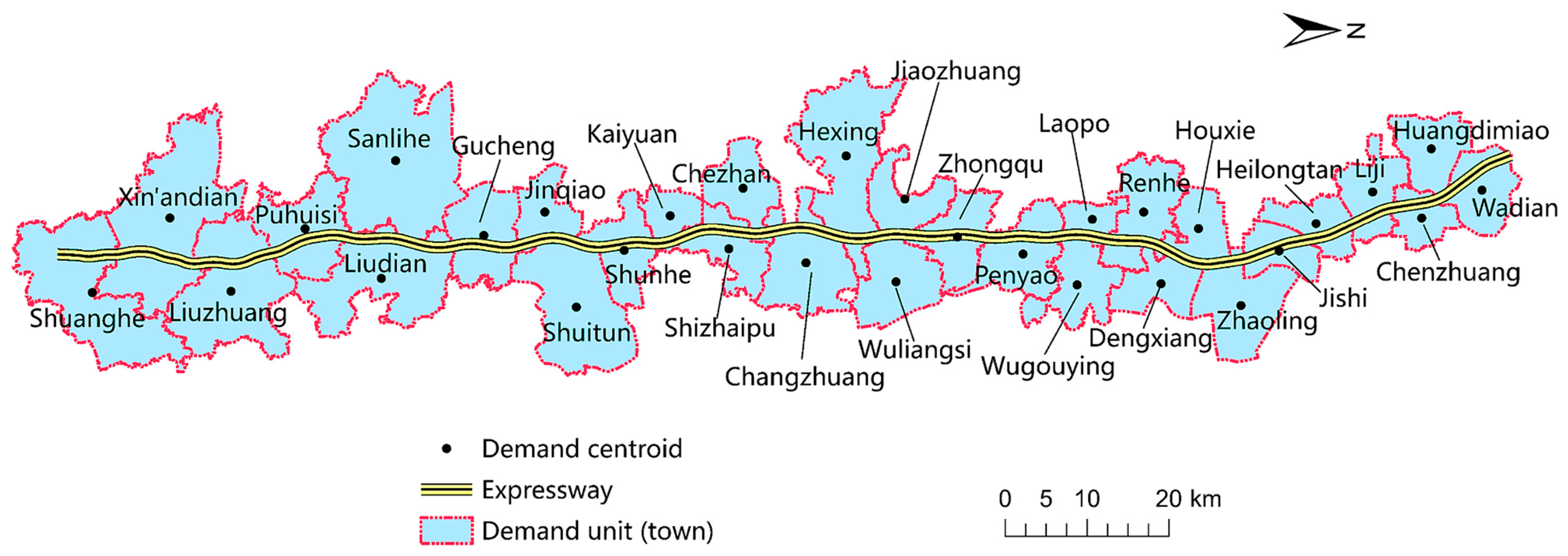
Figure 1. Schematic of the study scenario for the ramp spacing of expressway.
Systems 11 00139 g001
Figure 2. Comparison of evaluation indicators of several spacing alternatives.
Systems 11 00139 g002
Figure 3. The distribution of the ramps set according to A 11 within the demand-intensive area: (a) Demand-intensive area I; (b) Demand-intensive area II.
Systems 11 00139 g003
Figure 4. The distribution of the ramps set according to A 14 within the demand-intensive area: (a) Demand-intensive area I; (b) Demand-intensive area II.
Systems 11 00139 g004
Figure 5. Evaluation of ramp spacing alternatives under different traffic demands along the expressway.
Systems 11 00139 g005
Table 1. List of notations in the evaluation indicator system.
VariableNotation
Parameters
v ¯ the average speed
d ¯ the average delay
v i the speed of vehicle i
d i the delay of vehicle i
N the sample size of vehicles
ϵ the accident rate of 100 million vehicle- kilometers
σ the standard deviation of the speed of all vehicles
L i the comprehensive level of service of roads within the town i
α the grade of roads
l e n α the length of the road with grade α
h α the evaluation value of the road with class α
L e n i the total length of the roads passing through the town i
a i the accessibility of town i
l i j the distance from town i to ramp j
M i the comprehensive aggregation scale of town i
P the number of evaluation indicators for the comprehensive aggregation scale
γ k the weight of the k - th evaluation indicator
u i k the value of the k - th evaluation indicator of town i
ϕ the accessibility of the study district
Ω the project cost of constructing all ramps along the expressway section
ρ the density of ramps along the expressway section
l c the relevant parameter of the project cost
δ c
β c
Sets
R the set of ramps set according to spacing alternative
R i the set of ramps that can serve the town i , R R i
T the set of towns
Table 2. Evaluation indicator system of ramp spacing on expressway.
Indicator (Criterion)DimensionIndicator Source
Average speed ( v ¯ )positiveVISSIM simulation
Average delay ( d ¯ )negativeVISSIM simulation
Accident rate ( ϵ )negativeVISSIM simulation and calculation
Traffic accessibility ( ϕ )positiveCalculation based on data
Project cost ( Ω )negativeEvaluation based on ramp data and terrain conditions
Table 3. The weight of the evaluation indicators of the spacing alternatives.
Indicator
(Criterion)
Average
Speed
Average DelayAccident
Rate
Traffic
Accessibility
Project
Cost
Weight ( w j )0.202110.252850.169180.133400.24246
Table 4. Normalization decision matrix for spacing alternatives evaluation.
Spacing
Alternative
Decision Matrix
Average Speed Average DelayAccident RateTraffic AccessibilityProject Cost
A 1 0.470.660.541.000.00
A 2 0.000.290.660.980.05
A 3 0.650.720.920.990.10
A 4 1.000.800.670.960.15
A 5 0.430.600.870.940.20
A 6 0.810.740.800.920.25
A 7 0.550.701.000.910.30
A 8 0.961.000.410.860.35
A 9 0.580.920.670.830.40
A 10 0.440.460.290.850.45
A 11 0.890.680.640.710.50
A 12 0.040.490.000.710.55
A 13 0.700.640.420.600.60
A 14 0.190.080.190.560.65
A 15 0.790.350.590.550.70
A 16 0.650.430.210.510.75
A 17 0.350.000.420.440.80
A 18 0.520.360.320.370.85
A 19 0.130.120.240.240.90
A 20 0.280.050.320.200.95
A 21 0.450.070.340.001.00
Disclaimer/Publisher’s Note: The statements, opinions and data contained in all publications are solely those of the individual author(s) and contributor(s) and not of MDPI and/or the editor(s). MDPI and/or the editor(s) disclaim responsibility for any injury to people or property resulting from any ideas, methods, instructions or products referred to in the content.