

Application of TLS Technology for Documentation of Brickwork Heritage Buildings and Structures


Abstract
:1. Introduction
- Application of TLS in moisture detection in heritage buildings [20].
- Combined radiometric and geometric analysis of TLS data for heritage site preservation [21].
- Surface fractures and materials behaviour of cultural heritage buildings based on the point cloud [22].
- Three-dimensional digital documentation of cultural heritage site based on terrestrial laser scanning and unmanned aerial vehicle photogrammetry [26].
- Harnessing of terrestrial laser scanning in the maintenance of historic buildings [27].
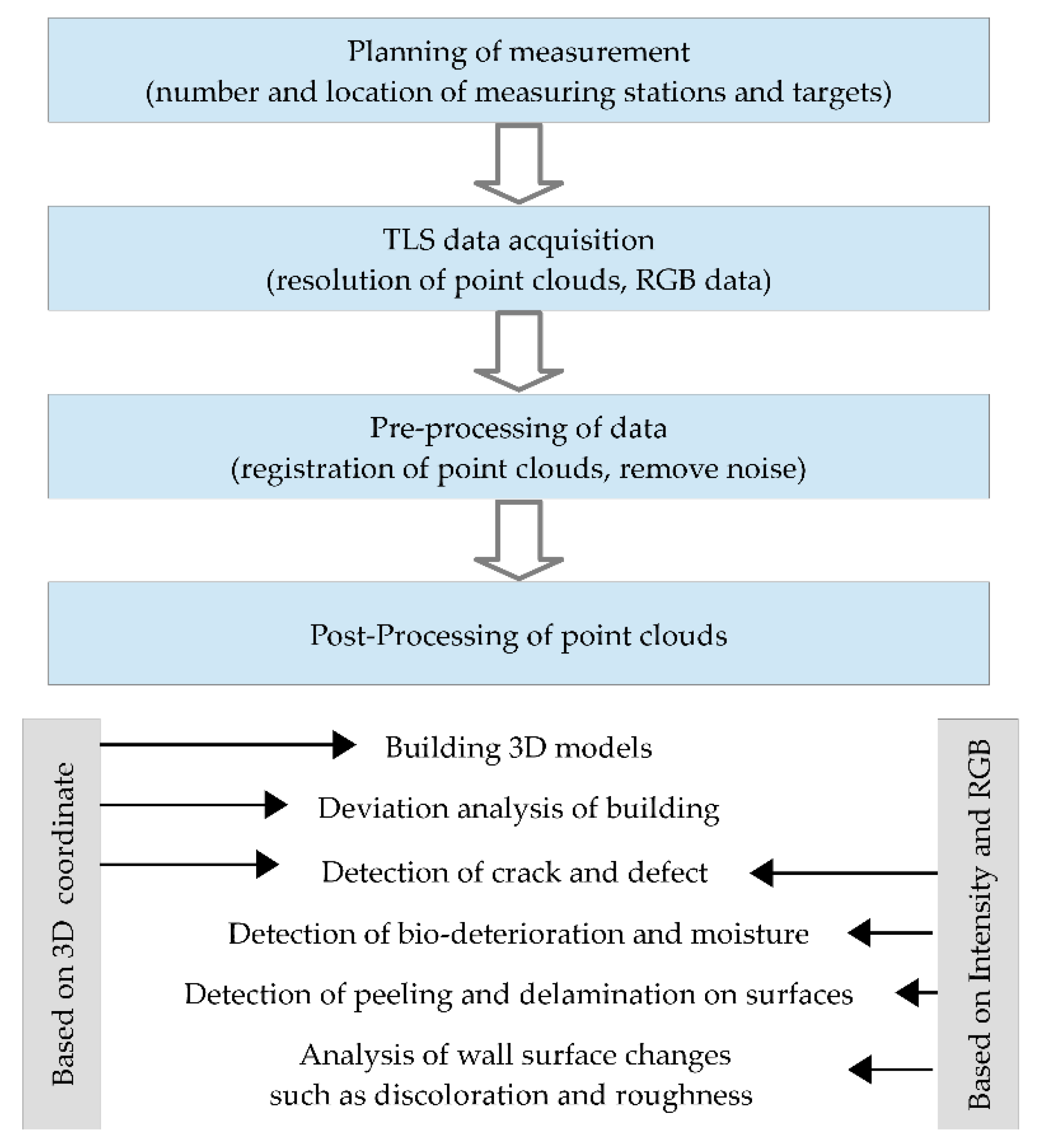
2. Materials and Methods
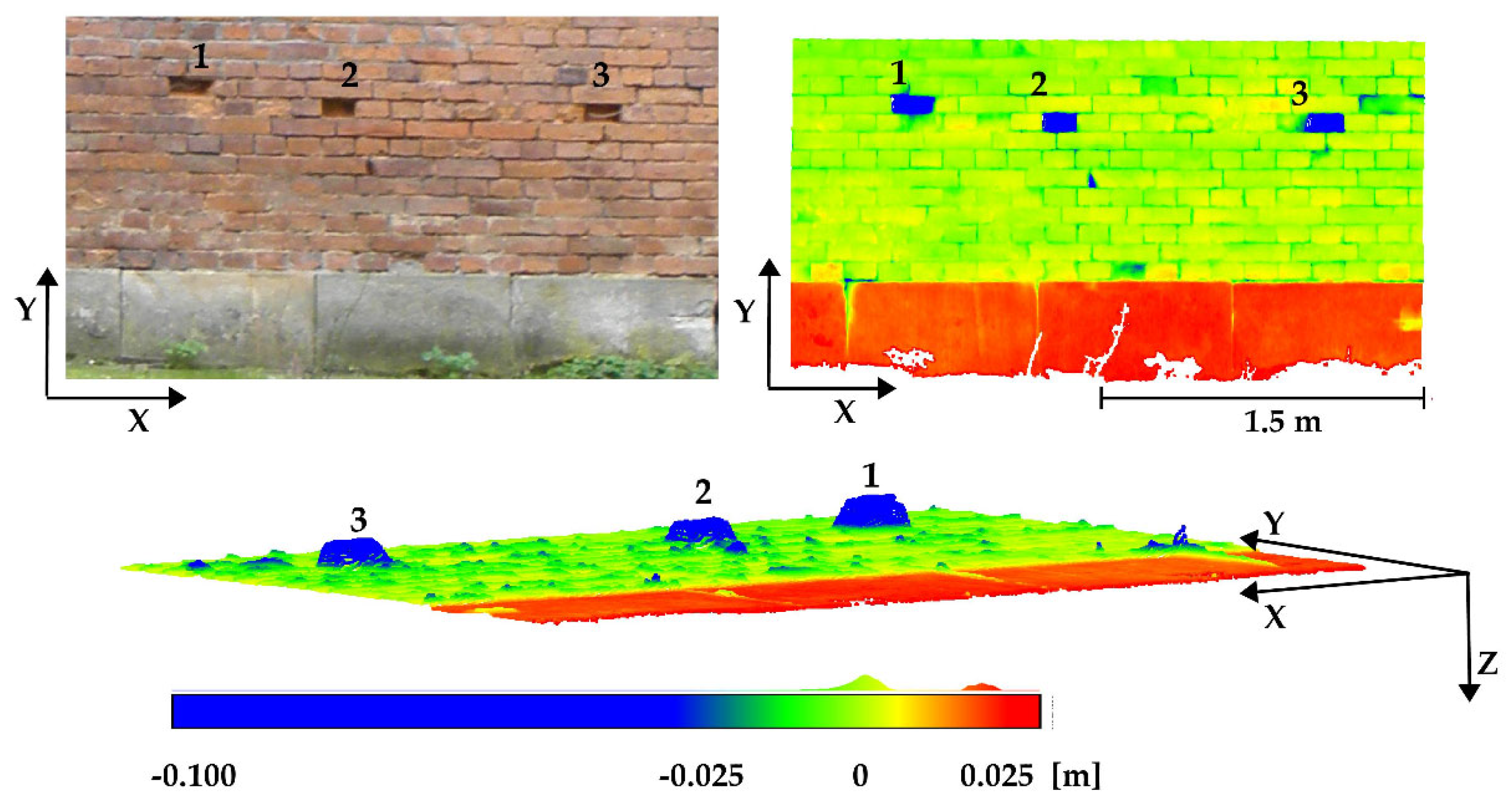
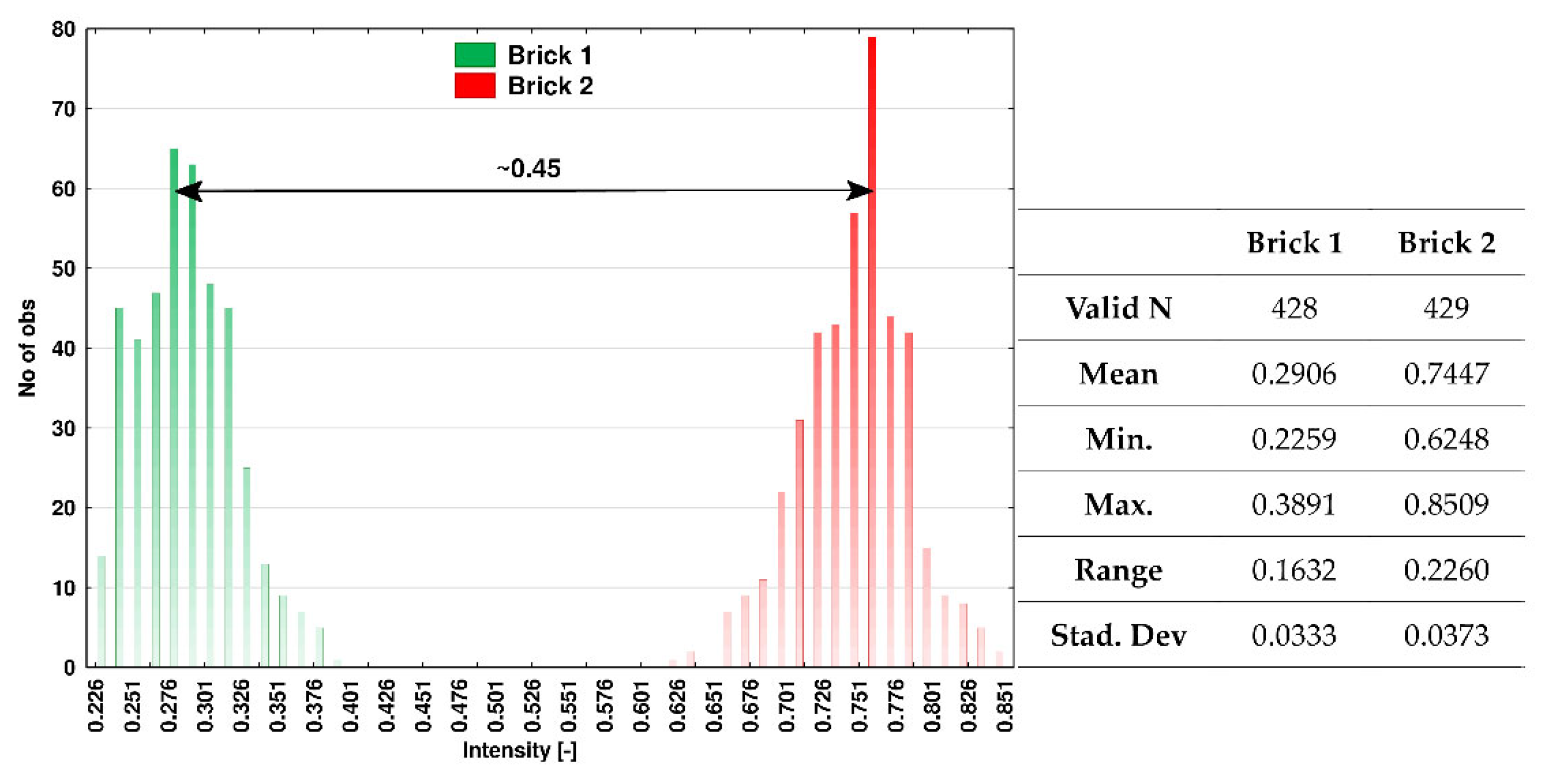
3. Results and Discussion
4. Conclusions
Author Contributions
Funding
Institutional Review Board Statement
Informed Consent Statement
Data Availability Statement
Conflicts of Interest
Appendix A


Appendix B

 | |
| Type of rangefinder | Phase-Shift |
| Type of wavelength | Infrared |
| Data acquisition rate | Max. 1.1 million pixel/s |
| Measurement range | 0.3 m–65 m |
| Distance scanning error | ±1 mm + 10 ppm/m |
| Beam diameter/divergence | ~ 3.5 mm @ 1m/~ 0.3 mrad (1/e2, half angle) |
| Angular resolution, vertically | 0.00026° (0.93 arcsec) |
| Angular resolution, horizontally | 0.00018° (0.65 arcsec) |
| Vertical accuracy | 0.004° (14.4 arcsec) rms |
| Horizontal accuracy | 0.004° (14.4 arcsec) rms |
| Operating temperature | −10 °C … +45 °C |
| Field of view (h/v) | 360°/320° |
| Additional sensors | HDR camera, optional IR camera, positioning system (barometer, acceleration sensor, gyroscope, compass, GPS) |
- Z+FLaserControl V9.2.2
- CloudCompar V2.12 alpha
References
- Marshall, G. Laser Beam Scanning: Opto-Mechanical Devices, Systems, and Data Storage Optics; Dekker: New York, NY, USA, 1985; ISBN 9780824774189. [Google Scholar]
- Blais, F. Review of 20 years of range sensor development. J. Electron. Imaging 2004, 13, 62–76. [Google Scholar] [CrossRef]
- Previtali, M.; Barazzetti, L.; Brumana, R.; Cuca, B.; Oreni, D.; Roncoroni, F.; Scaioni, M. Automatic façade modelling using point cloud data for energy-efficient retrofitting. Appl. Geomat. 2014, 6, 95–113. [Google Scholar] [CrossRef]
- Nowak, R.; Kania, T.; Rutkowski, R.; Ekiert, E. Research and TLS (LiDAR) Construction Diagnostics of Clay Brick Masonry Arched Stairs. Materials 2022, 15, 552. [Google Scholar] [CrossRef] [PubMed]
- Riveiro, B.; Morer, P.; Arias, P.; De Arteaga, I. Terrestrial laser scanning and limit analysis of masonry arch bridges. Constr. Build. Mater. 2011, 25, 1726–1735. [Google Scholar] [CrossRef]
- Valença, J.; Puente, I.; Júlio, E.; González-Jorge, H.; Arias-Sánchez, P. Assessment of cracks on concrete bridges using image processing supported by laser scanning survey. Constr. Build. Mater. 2017, 146, 668–678. [Google Scholar] [CrossRef]
- Iglhaut, J.; Cabo, C.; Puliti, S.; Piermattei, L.; O’Connor, J.; Rosette, J. Structure from Motion Photogrammetry in Forestry: A Review. Curr. For. Rep. 2019, 5, 155–168. [Google Scholar] [CrossRef] [Green Version]
- Park, H.S.; Lee, H.M.; Adeli, H.; Lee, I. A new approach for health monitoring of structures: Terrestrial laser scanning. Comput. Civ. Infrastruct. Eng. 2007, 22, 19–30. [Google Scholar] [CrossRef]
- Alba, M.; Fregonese, L.; Prandi, F.; Scaioni, M.; Valgoi, P. Structural monitoring of a large dam by terrestrial laser scanning. Int. Arch. Photogramm. Remote Sens. Spat. Inf. Sci. 2006, 36, 6. [Google Scholar]
- Li, Y.; Liu, P.; Li, H.; Huang, F. A comparison method for 3D laser point clouds in displacement change detection for arch dams. ISPRS Int. J. Geo-Inf. 2021, 10, 184. [Google Scholar] [CrossRef]
- Argüelles-Fraga, R.; Ordóñez, C.; García-Cortés, S.; Roca-Pardiñas, J. Measurement planning for circular cross-section tunnels using terrestrial laser scanning. Autom. Constr. 2013, 31, 1–9. [Google Scholar] [CrossRef]
- Sánchez-Rodríguez, A.; Riveiro, B.; Soilán, M.; González-deSantos, L.M. Automated detection and decomposition of railway tunnels from Mobile Laser Scanning Datasets. Autom. Constr. 2018, 96, 171–179. [Google Scholar] [CrossRef]
- Teza, G.; Galgaro, A.; Zaltron, N.; Genevois, R. Terrestrial laser scanner to detect landslide displacement fields: A new approach. Int. J. Remote Sens. 2007, 29, 3425–3446. [Google Scholar] [CrossRef]
- Suchocki, C. Application of terrestrial laser scanner in cliff shores monitoring. Rocz. Ochr. Sr. 2009, 11, 715–725. [Google Scholar]
- Suchocki, C.; Katzer, J. An example of harnessing Terrestrial Laser Scanner for remote sensing of saturation of chosen building materials. Constr. Build. Mater. 2016, 122, 400–405. [Google Scholar] [CrossRef]
- Tan, K.; Cheng, X.; Ju, Q.; Wu, S. Correction of Mobile TLS Intensity Data for Water Leakage Spots Detection in Metro Tunnels. IEEE Geosci. Remote Sens. Lett. 2016, 13, 1711–1715. [Google Scholar] [CrossRef]
- Suchocki, C.; Damięcka-Suchocka, M.; Katzer, J.; Janicka, J.; Rapiński, J.; Stałowska, P. Remote Detection of Moisture and Bio-Deterioration of Building Walls by Time-of-Flight and Phase-Shift Terrestrial Laser Scanners. Remote Sens. 2020, 12, 1708. [Google Scholar] [CrossRef]
- De Blasiis, M.R.; Di Benedetto, A.; Fiani, M.; Garozzo, M. Assessing of the road pavement roughness by means of lidar technology. Coatings 2021, 11, 17. [Google Scholar] [CrossRef]
- Katzer, J.; Suchocki, C.; Błaszczak-Bąk, W.; Zarzycki, P.K.; Damięcka-Suchocka, M. Reliability and effectiveness of laser scanners in future construction efforts on the Moon and Mars. Autom. Constr. 2021, 132, 103979. [Google Scholar] [CrossRef]
- Lerones, P.M.; Vélez, D.O.; Rojo, F.G.; Gómez-García-Bermejo, J.; Casanova, E.Z. Moisture detection in heritage buildings by 3D laser scanning. Stud. Conserv. 2016, 61, 46–54. [Google Scholar] [CrossRef]
- Sánchez-Aparicio, L.J.; Del Pozo, S.; Ramos, L.F.; Arce, A.; Fernandes, F.M. Heritage site preservation with combined radiometric and geometric analysis of TLS data. Autom. Constr. 2018, 85, 24–39. [Google Scholar] [CrossRef]
- Alkadri, M.F.; Alam, S.; Santosa, H.; Yudono, A.; Beselly, S.M. Investigating Surface Fractures and Materials Behavior of Cultural Heritage Buildings Based on the Attribute Information of Point Clouds Stored in the TLS Dataset. Remote Sens. 2022, 14, 410. [Google Scholar] [CrossRef]
- Cardenal Escarcena, J.; Mata de Castro, E.; Pérez García, J.L.; Mozas Calvache, A.; Fernández del Castillo, T.; Delgado García, J.; Ureña Cámara, M.; Castillo, J.C. Integration of photogrammetric and terrestrial laser scanning techniques for heritage documentation. Virtual Archaeol. Rev. 2011, 2, 53–57. [Google Scholar] [CrossRef]
- Rüther, H.; Smit, J.; Kamamba, D. A Comparison of Close-Range Photogrammetry to Terrestrial Laser Scanning for Heritage Documentation. South Afr. J. Geomat. 2012, 1, 149–162. [Google Scholar]
- Xu, Z.; Wu, L.; Shen, Y.; Li, F.; Wang, Q.; Wang, R. Tridimensional reconstruction applied to cultural heritage with the use of camera-equipped UAV and terrestrial laser scanner. Remote Sens. 2014, 6, 10413–10434. [Google Scholar] [CrossRef] [Green Version]
- Jo, Y.; Hong, S. Three-Dimensional Digital Documentation of Cultural Heritage Site Based on the Convergence of Terrestrial Laser Scanning and Unmanned Aerial Vehicle Photogrammetry. ISPRS Int. J. Geo-Inf. 2019, 8, 53. [Google Scholar] [CrossRef] [Green Version]
- Bernat, M.; Janowski, A.; Rzepa, S.; Sobieraj, A.; Szulwic, J. Studies on the use of terrestrial laser scanning in the maintenance of buildings belonging to the cultural heritage. In Proceedings of the International Multidisciplinary Scientific GeoConference Surveying Geology and Mining Ecology Management, SGEM, Albena, Bulgaria, 17–26 June 2014; Volume 3, pp. 307–318. [Google Scholar]
- Nowak, R.; Orłowicz, R.; Rutkowski, R. Use of TLS (LiDAR) for building diagnostics with the example of a historic building in karlino. Buildings 2020, 10, 24. [Google Scholar] [CrossRef] [Green Version]
- Herráeza, J.; Navarrob, P.; Deniaa, J.L.; Martínc, M.T.; Rodríguezc, J. Modeling the thickness of vaults in the church of Santa Maria de Magdalena (Valencia, Spain) with laser scanning techniques. J. Cult. Herit. 2014, 15, 679–686. [Google Scholar] [CrossRef]
- Suchocki, C.; Katzer, J. TLS technology in brick walls inspection. In Proceedings of the 2018 Baltic Geodetic Congress (BGC Geomatics), Olsztyn, Poland, 21–23 June 2018; pp. 359–363. [Google Scholar]
- Suchocki, C.; Katzer, J.; Panuś, A. Remote Sensing to Estimate Saturation Differences of Chosen Building Materials Using Terrestrial Laser Scanner. Rep. Geod. Geoinformatics 2017, 103, 94–105. [Google Scholar] [CrossRef] [Green Version]
- Aryan, A.; Bosché, F.; Tang, P. Planning for terrestrial laser scanning in construction: A review. Autom. Constr. 2021, 125, 103551. [Google Scholar] [CrossRef]
- Tang, P.; Alaswad, F.S. Sensor modeling of laser scanners for automated scan planning on construction jobsites. In Proceedings of the Construction Research Congress 2012, West Lafayette, IN, USA, 21–23 May 2012; pp. 1021–1031. [Google Scholar]
- Adamopoulos, E.; Patrucco, G.; Volinia, M.; Girotto, M.; Rinaudo, F.; Tonolo, F.G.; Spanò, A. 3D Thermal Mapping of Architectural Heritage: Up-To-Date Workflows for the production of three-dimensional thermographic models for built heritage NDT. In Lecture Notes in Computer Science (Including Subseries Lecture Notes in Artificial Intelligence and Lecture Notes in Bioinformatics); Springer: Berlin/Heidelberg, Germany, 2021; Volume 12642. [Google Scholar]
- Cheng, L.; Chen, S.; Liu, X.; Xu, H.; Wu, Y.; Li, M.; Chen, Y. Registration of laser scanning point clouds: A review. Sensors 2018, 18, 1641. [Google Scholar] [CrossRef] [Green Version]
- Favre, K.; Pressigout, M.; Marchand, E.; Morin, L. A plane-based approach for indoor point clouds registration. In Proceedings of the International Conference on Pattern Recognition, Milan, Italy, 10–15 January 2020; pp. 1–8. [Google Scholar]
- Nothegger, C.; Dorninger, P. 3D filtering of high-resolution terrestrial laser scanner point clouds for cultural heritage documentation. Photogramm. Fernerkund. Geoinf. 2009, 2009, 53–63. [Google Scholar] [CrossRef] [Green Version]
- Gao, R.; Li, M.; Yang, S.J.; Cho, K. Reflective Noise Filtering of Large-Scale Point Cloud Using Transformer. Remote Sens. 2022, 14, 577. [Google Scholar] [CrossRef]
- Da Silva, W.R.L.; de Lucena, D.S. Concrete Cracks Detection Based on Deep Learning Image Classification. Proceedings 2018, 2, 1–6. [Google Scholar]
- Yang, C.; Chen, J.; Li, Z.; Huang, Y. Structural crack detection and recognition based on deep learning. Appl. Sci. 2021, 11, 2868. [Google Scholar] [CrossRef]
- Yamane, T.; Chun, P.J. Crack detection from a concrete surface image based on semantic segmentation using deep learning. J. Adv. Concr. Technol. 2020, 18, 493–504. [Google Scholar] [CrossRef]
- Czerniawski, T.; Leite, F. 3DFacilities: Annotated 3D reconstructions of building facilities. In Notes in Computer Science (Including Subseries Lecture Notes in Artificial Intelligence and Lecture Notes in Bioinformatics); Springer: Berlin/Heidelberg, Germany, 2018; Volume 10863, pp. 186–200. [Google Scholar]
- Xu, X.; Yang, H. Intelligent crack extraction and analysis for tunnel structures with terrestrial laser scanning measurement. Adv. Mech. Eng. 2019, 11, 1687814019872650. [Google Scholar] [CrossRef]
- Guldur Erkal, B.; Hajjar, J.F. Laser-based surface damage detection and quantification using predicted surface properties. Autom. Constr. 2017, 83, 285–302. [Google Scholar] [CrossRef]
- Stałowska, P.; Suchocki, C.; Rutkowska, M. Crack detection in building walls based on geometric and radiometric point cloud information. Autom. Constr. 2022, 134, 104065. [Google Scholar] [CrossRef]
- Suchocki, C.; Damięcka, M.; Jagoda, M. Determination of the building wall deviations from the vertical plane. In Proceedings of the 7th International Conference on Environmental Engineering, ICEE, Vilnius, Lithuania, 22–23 May 2008; pp. 1488–1492. [Google Scholar]
- Chen, S.-E. Laser scanning technology for bridge monitoring. In Laser Scanner Technology; IntechOpen: London, UK, 2012. [Google Scholar]
- Kazhdan, M.; Chuang, M.; Rusinkiewicz, S.; Hoppe, H. Poisson Surface Reconstruction with Envelope Constraints. Comput. Graph. Forum 2020, 39, 173–182. [Google Scholar] [CrossRef]
- Alkan, R.M.; Karsidag, G. Analysis of the Accuracy of Terrestrial Laser Scanning Measurements. In Proceedings of the FIG Working Week, Rome, Italy, 6–10 May 2012; pp. 1–16. [Google Scholar]
- Mechelke, K.; Kersten, T.P.; Lindstaedt, M. Comparative Investigation into the Accuarcy Behaviour of the New Generation of Terrestrial Laser Scanning Systems. In Proceedings of the 8th Conference on Optical 3D Measurement Techniques, Zurich, Switzerland, 9–12 July 2007; Volume 1, pp. 319–327. [Google Scholar]
- Tucker, C. Testing and verification of the accuracy of 3D laser scanning data. In Proceedings of the Symposium on Geospatial Theory, Processing and Applications, Ottawa, ON, Canada, 9–12 July 2002; pp. 1–6. [Google Scholar]


Publisher’s Note: MDPI stays neutral with regard to jurisdictional claims in published maps and institutional affiliations. |
© 2022 by the authors. Licensee MDPI, Basel, Switzerland. This article is an open access article distributed under the terms and conditions of the Creative Commons Attribution (CC BY) license (https://creativecommons.org/licenses/by/4.0/).
Share and Cite
Damięcka-Suchocka, M.; Katzer, J.; Suchocki, C. Application of TLS Technology for Documentation of Brickwork Heritage Buildings and Structures. Coatings 2022, 12, 1963. https://doi.org/10.3390/coatings12121963
Damięcka-Suchocka M, Katzer J, Suchocki C. Application of TLS Technology for Documentation of Brickwork Heritage Buildings and Structures. Coatings. 2022; 12(12):1963. https://doi.org/10.3390/coatings12121963
Chicago/Turabian StyleDamięcka-Suchocka, Marzena, Jacek Katzer, and Czesław Suchocki. 2022. "Application of TLS Technology for Documentation of Brickwork Heritage Buildings and Structures" Coatings 12, no. 12: 1963. https://doi.org/10.3390/coatings12121963
APA StyleDamięcka-Suchocka, M., Katzer, J., & Suchocki, C. (2022). Application of TLS Technology for Documentation of Brickwork Heritage Buildings and Structures. Coatings, 12(12), 1963. https://doi.org/10.3390/coatings12121963