1. Introduction
Buddhism development history in China: It is generally believed that Buddhism initially arrived in mainland China via the Silk Road during the Han Dynasty (202 BCE–220 CE), before expanding considerably in the Northern Wei Dynasty (between 420 and 589 CE) to reached its peak during the Sui and Tang Dynasties (between 581 and 907 CE) (
Liang 1961;
Chʻen 1972;
Han 1979;
Fu 1998). The global trade networks served as the enabler for international Buddhist pilgrimages between India and China. Pilgrims, traversing well-established trade routes, played a pivotal role in the widespread dissemination of Buddhism on a global scale, extending its influence as far as Mount Wutai during the Eastern Han Period (28–75 CE). Along these sacred pilgrimage routes, strategically positioned stations functioned as vital links connecting urban centers to remote mountainous regions of profound Buddhist significance.
Scholars have contributed invaluable differing insights into the pilgrimage, sacred landscape, and gradual transformation of Mount Wutai into a revered Buddhist destination, such as
Dorothy C. Wong (
1993),
Wen-shing Chou (
2011), and
Wei-Cheng Lin (
2014), etc. Meanwhile, seventeen studies, which were initially presented at a 2015 conference held at Dasheng Zhulin Si in China, have been compiled and published in the book titled,
The Transnational Cult of Mount Wutai: Historical and Comparative Perspectives (
Andrews et al. 2020). There were four international conferences on the Wutai cult that gathered various ideas from scholars worldwide. These conferences were organized successively by the ‘Form the Group Up (Buddhism and East Asian Religions)’ and ‘GLORISUN (Global Buddhist Network)’ between 2015 and 2018. In the latest scholarly work titled,
What Happened After Mañjuśrī Migrated to China? The Sinification of the Mañjuśrī Faith and the Globalization of the Wutai Cult, edited by
Chen et al. (
2022), delves into novel perspectives on the transformation of the Mañjuśrī cult centered on Mount Wutai, examining its replication in China and beyond. This examination encompasses a multidisciplinary exploration, including literature, architecture, medicine, society, philosophy, art, and history. However, in this extensive body of literature, Mount Wutai has been subjected to rich analysis, interpretations, and speculations due to the dynamic predominance of Buddhist cults on Mount Wutai. The monastic stations, settings, and landscape on Mount Wutai were also (re)shaped and underwent syncretic transformations in accordance with changing meanings. Scholars have rarely considered how changing Buddhist cults on Mount Wutai affected the practice of physical construction and pilgrimage over centuries.
Scholars state that Mount Wutai played a pivotal role as the ‘Esoteric Buddhism Mountain’ during the Tang Dynasty.
Geoffrey Goble (
2020) posits that Emperor Daizong of the Tang Dynasty officially endorsed Esoteric Buddhism as the predominant Buddhist tradition in China, effectively superseding other Buddhist teachings.
Goble (
2020) further contends that Daizong played a pivotal role in facilitating Amoghavajra’s establishment of Esoteric Buddhism and held Mañjuśrī in particularly high regard on Mount Wutai. However, if this is indeed the case, how Esoteric Buddhism and the Mañjuśrī cult shaped the monastic stations, landscape, and pilgrimage routes on Mount Wutai during the Tang period remains a gap in our understanding. Furthermore, when Tibetan Buddhism became the predominant Buddhist tradition on Mount Wutai, patronized by imperial courts from the Ming Dynasty (1368–1644 CE) to the Qing Dynasty (1616–1912 CE) (
Guang 2010), how its monastic stations, pilgrimage routes, and landscape retained their previous spiritual significance while assimilating with the new prevalent Tibetan Buddhism is a topic that has received limited attention from scholars. Based on these research gaps, this article’s examination is grounded in a critical review of well-known historical texts, literature, and visual maps of Mount Wutai.
2. Methodology
To acquire information concerning the historical monastic sites, changing landscapes, and the Buddhist pilgrimage on Mount Wutai spanning multiple centuries, the article employs archival studies, literature review, and personal experiences of pilgrimage on Mount Wutai.
Firstly, the research has gathered several valuable archives, including the historical texts, such as ‘The Record of a Pilgrimage to China in Search of the Law’ from the Chinese Buddhist Electronic Text Association (CBETA), and indicates that pilgrims worshiped Mount Wutai during the Tang Dynasty; ‘Qing Liang Shan Zhi’ and ancient maps of Mount Wutai were accessed from the Library of Congress. These ancient maps illustrate the evolving significance of Mount Wutai during different historical periods, providing insights for analyzing the changes in pilgrimage routes and monastic stations across centuries.
In addition, the literature review includes the Buddhist Mountains in China and publications related to Mount Wutai. This review examines changes and perceptions of Buddhist Mountains, highlighting the contribution of this research to understanding the evolution of Buddhist practices in Mount Wutai and the transformations occurring in the region.
Furthermore, the author experienced the pilgrimage to the Five Peaks of Mount Wutai in 2020. This involved meticulous observation of contemporary tourism on Mount Wutai and the author’s own participation in the pilgrimage routes from Foguang Monastery to Mount Wutai, as well as the circumambulation route around the Five Peaks on Mount Wutai. Through this process, the author developed a fundamental awareness and understanding of Buddhist pilgrimage, while also identifying the inherent relationship between nature, geography, and Foguang Monastery’s connection to Mount Wutai. Furthermore, the author collected numerous aerial photos and terrestrial photos of the current topography of the Five Peaks, and monasteries on Mount Wutai, and generated the entire map of this area based on the primary photographs, Google Earth, and digital maps.
3. Mount Wutai
There are four revered Buddhist pilgrimage sites in China: Mount Wutai, Mount E’mei, Mount Putuo, and Mount Jiuhua. Among these sites, Mount Wutai is the first of the sacred mountains of Buddhism in China (
Birnhaum 1983), and, in light of such recognition, the site was included in the World Heritage List of Culture Heritage at the end of 2009. In particular, it stands out as one of the oldest and holiest, which is of great historical and cultural significance, with a rich heritage of cultural exchange and religious practice spanning more than 2000 years as a center of Buddhist worship (
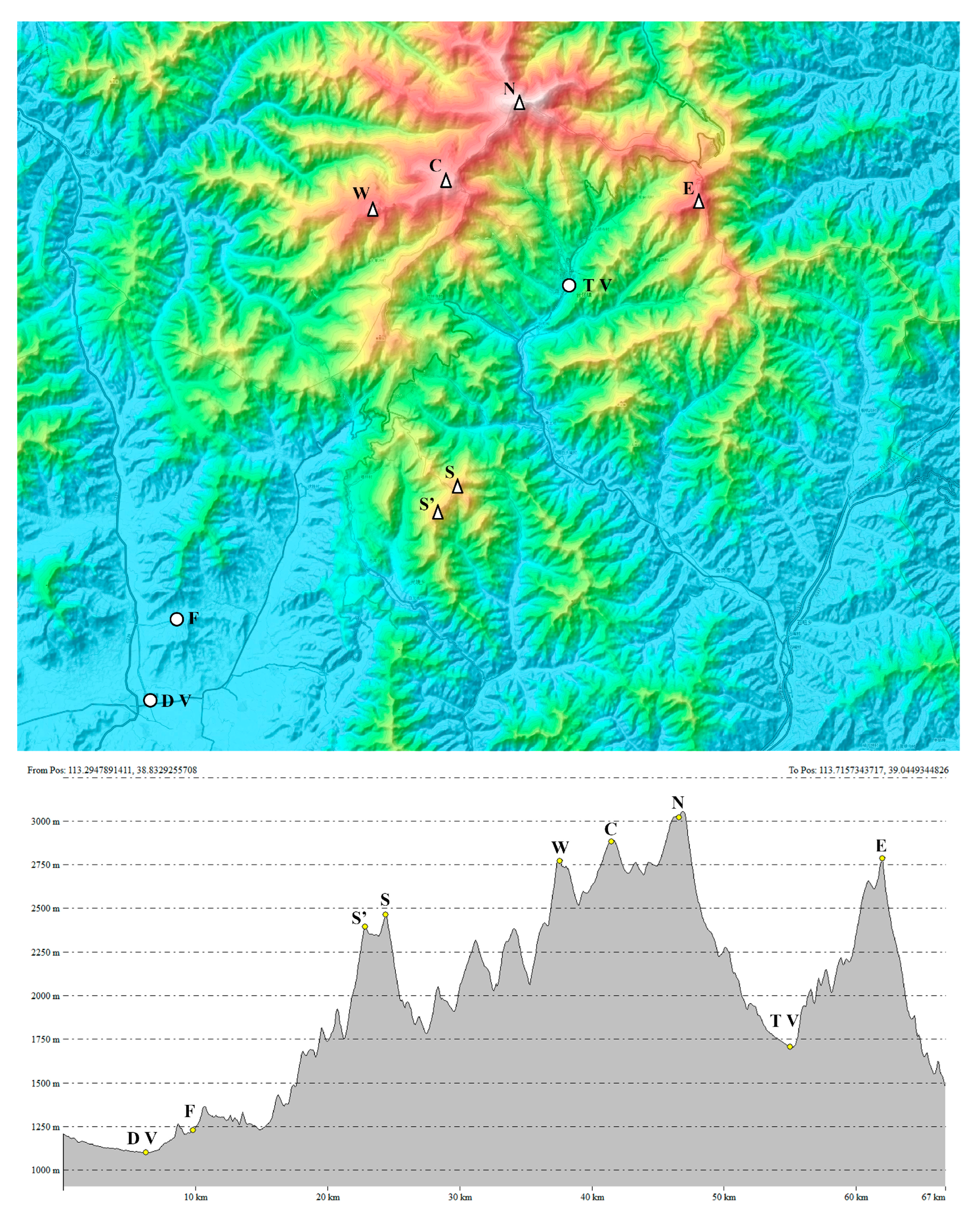
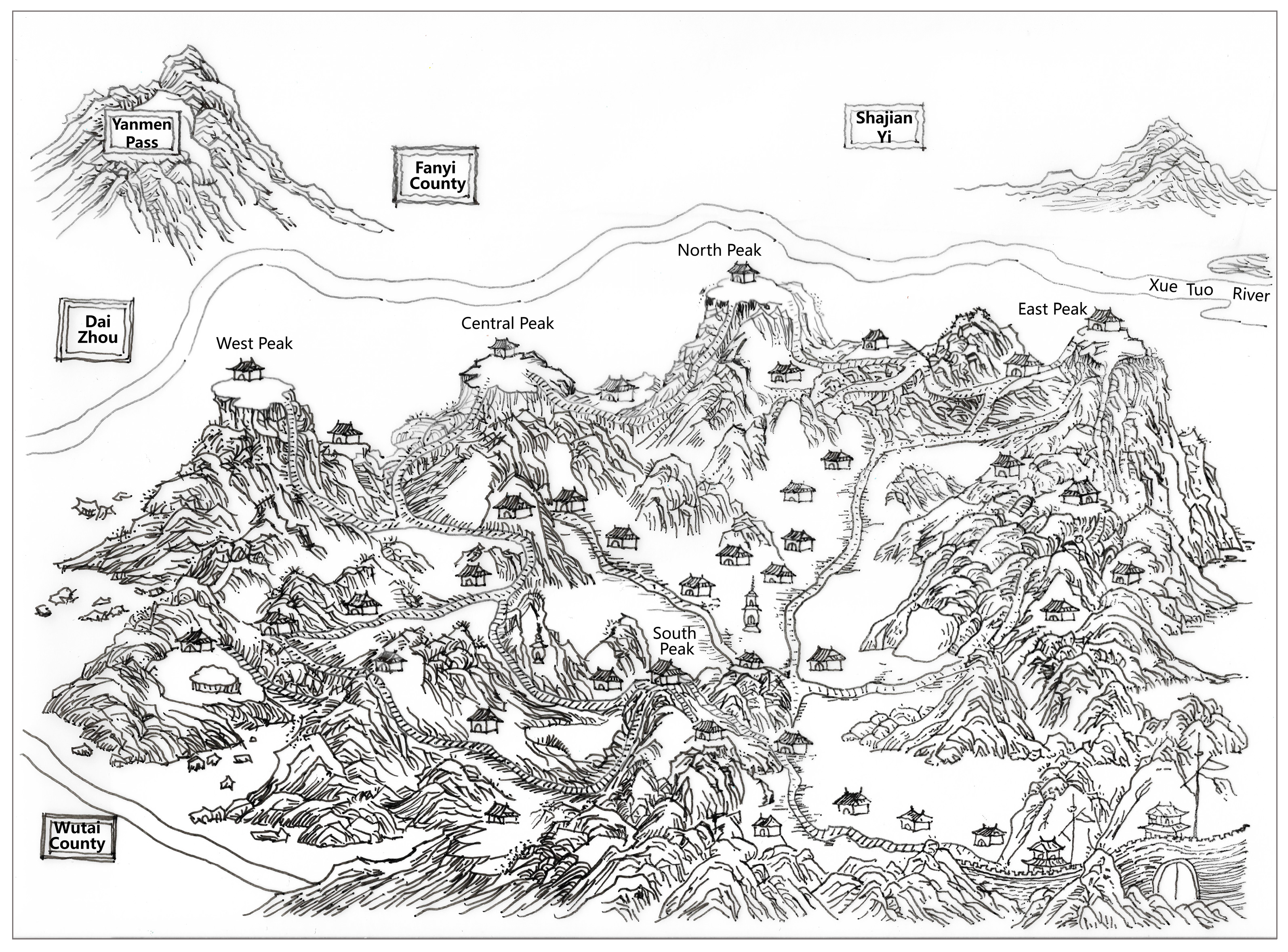
Cui 2016). Located in Wutai County, positioned north of the Yellow River in northeast China (currently in Shanxi Province), Mount Wutai is a cluster of mountains, characterized by a unique topography with five high-terraced and barren landscape peaks, namely, the west, central, north, south, and east peaks. There are significant differences in altitude and topography between its northern and southern parts. The summit altitudes among the Five Peaks gradually increase from the south to the western and central peaks and finally to the northern, before dropping in altitude at the east peak (
Figure 1).
The mountain has been known by different names throughout history, including Mount Zifu, meaning ‘palace of the Taoist immortals’, as it used to be a Taoist sanctuary before Buddhism occupied the area (
Chen 1726); Mount Wufeng, which reflects its unique physical features, including high terraces and five flat peaks. Due to its imposing height, it was formerly known as Mount Qingliang, and the cool temperatures in the mountain region contributed to its reputation (
Ennin 838–845;
Zhen 1596).
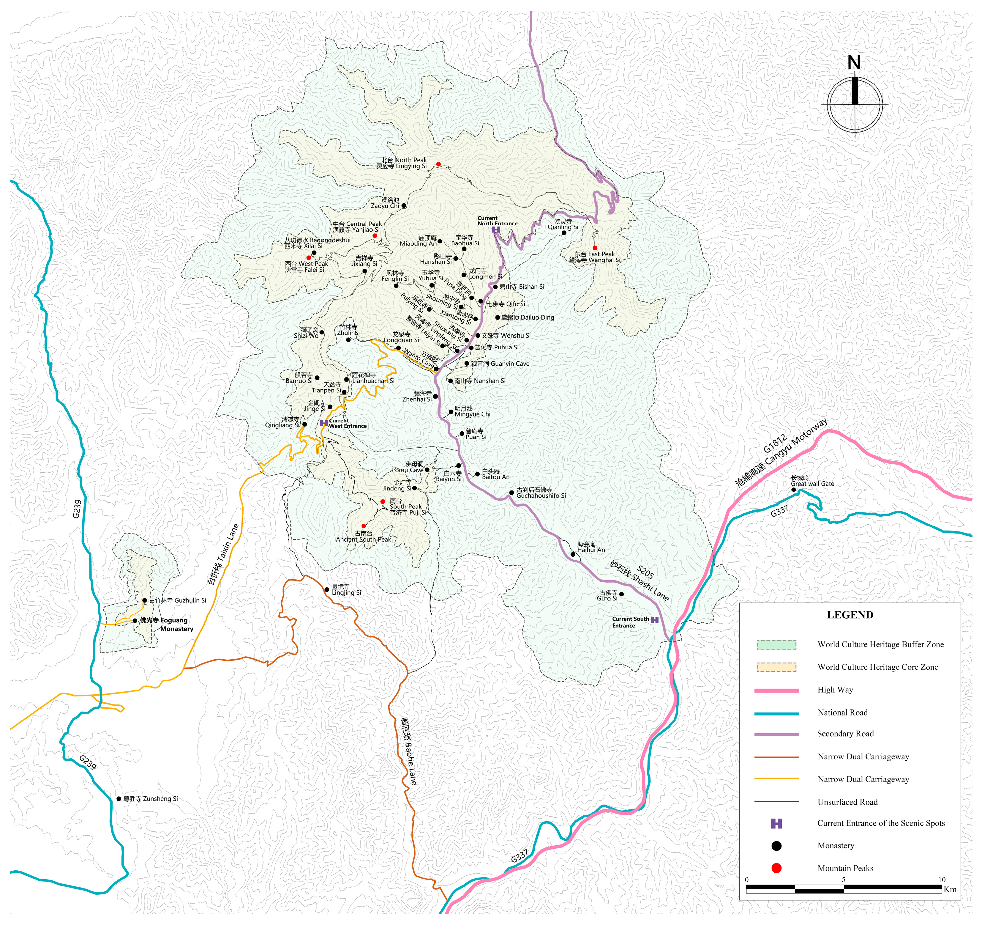
Mount Wutai, regarded as one of the earliest sacred sites in Buddhism, aligns with this development trajectory while possessing distinctive characteristics of its own. This is a remote and unique region where the land, structures, and inhabitants are all influenced, either directly or indirectly, by Buddhism. Its geographical range has been proposed to encompass a substantial expanse, totaling 607.43 square kilometers. The core zone of the Wutai Mountain Scenic Area, also referred to as Mount Wutai Park, is primarily defined by its five peaks and covers an area of 592.88 square kilometers, which includes the location of Taihuai Villages. Taihuai Village is nestled at the foot of the five flat peaks, hosting numerous monasteries. Its altitude (1700 m) is notably higher than that of the other nearby villages, which contributes to the village’s unique cultural and religious significance. Several monasteries are located beyond the core zone, including the Foguang Monastery, considered one of the most celebrated monasteries in China. Established in 857 CE, it stands as one of the oldest surviving monastic buildings in the country (
Figure 2).
Before the advent of Buddhism on Mount Wutai, religious practices in the region were already deeply rooted in Chinese mountain culture, with a strong emphasis on mountain worship. The
Book of Rites1 reports that the ancient rituals of the emperors during the Warring States period (475–221 BCE) took place on five divine mountains. Taoism also worships nature and rivers, especially mountains. For example, Taoists always carry the Genuine Map of the Five Sacred Mountains with them when they set out on long and arduous treks, as they firmly believe that this symbolic map, on which the five great mountains of China were marked by the Chinese ancestors, could protect them from accidental injury or threat.
2 As Zhang Lin created Taoism on Mount E’mei in the middle and late Eastern Han Dynasty (180–220 CE) (
Jia 2010), Taoism quickly spread to Mount Wutai: according to the Qingliang Shan Zhi (
Zhen 1596, followers practiced in huts and caves there).
The construction of the first monastery (Dafu Lingjiu Monastery) in the Mount Wutai area not only sanctified this land but also indicates the dominant role of political legitimization for the development of Buddhism. Emperor Ming, as a devotee of Buddhism, was convinced of the request by the Indian Buddhists and approved the construction of the monastery (
Zhen 1596). According to a description in
Qingliang Shan Zhi,
‘there are 64 monasteries in the span of the Five Peaks, and the first Monastery is Great Xiantong, originally called Dafu Lingjiu Monastery, means Holy Eagle. During the reign of Emperor Ming of Han (28–75 CE), the Indian Buddhist monks Kasyapa Matanga and Dharmaratna visited mainland China. When they visited to Mount Wutai, they proposed to the emperor that they wanted to establish a monastery in the village of Taihuai on Mount Wutai, as this place was the residence of Mañjuśrī and possessed the Buddha relics, and the typography in this landscape corresponded to the situation on the Holy Eagle Peak of Rājagṛha in Indian’.3
Because all patrons believed that they could accumulate merits by funding large-scale construction projects, followers of Buddhism actively participated in numerous prominent Buddhist architectural endeavors within their localities, especially during the initial construction surge in the Northern Wei Dynasty (
Wang 2023). According to Fa Lin’s work on
Dialectics, in 477 CE, during the Northern Wei period, the number of Buddhists numbered no more than 77,000; however, over the next 60 years, this figure experienced a dramatic increase, reaching approximately 2,000,000, considering that the total population of northern China was around 30 million during the same period (
Fa 618–907).
During the Tang Dynasty, Buddhism reached its peak in mainland China, and this trend was reflected in the practice of Buddhism at Mount Wutai. The government invested a significant amount of human and material resources in constructing Buddhist temples, caves, and other forms of monuments, leading to an unprecedented scale of Buddhist belief. During the Tang period (618–907 CE), especially under the emperors Daizong, Xuanzong, and Zhaozong, 3901 monasteries were built (
Zhang 1902). The initial excavation of fifty-two caves in the Dunhuang Grottoes revealed fifty-six frescoes depicting Mañjuśrī Jingtu Bian (
Hu and Fu 1997). Additionally, the Longmen Grottoes underwent two extensive excavation phases during the Northern Wei and Tang Dynasties, spanning over 140 years, and according to 1962 statistics, more than 2100 ancient cave niches and 100,000 Buddha statues were found, including the 17.14-m-tall Lu She Na Buddha (
Gong 2002). About 60 percent of these construction projects were completed during the Tang Dynasty, compared to 30 percent during the Northern Wei (
Li 2020).
The development of monasteries under the Tang regime entailed multifaceted interventions. These interventions encompassed various aspects, including the number of monastic buildings, the nomenclature of monasteries, the typology of monastic construction, and the demographics of Buddhists. The construction regulations held during the Tang Dynasty administration were notably distinguished by a greater degree of systematicity and standardization. Monasteries were divided into three classes, and the number of monks was divided depending on the monastic classes, according to:
The History of Tang dynasty. ‘Five new monasteries were constructed with official funding in Mount Wutai, and all surviving monasteries would were restored and recorded; every monastery would add fifty monks, and must develop a nunnery there. In addition, the emperors appointed 5358 monastery plaques for the whole Tang land.
The plaque is a flat, square piece of wood usually bearing a name and dates, attached to a door to display the name of the monastery. This signifies that a total of 5358 monasteries were officially recognized and documented by the state. In addition, Buddhists who visited a monastery in the Tang Dynasty were tracked with the ‘dudie’,
5 an official certificate from the government proving that Buddhists had to obtain permission before embarking on a pilgrimage. This system was also proven by the Japanese Buddhist Ennin when he visited various Pilgrimage centers and Buddhist shrines in Tang-era China. Mount Wutai was finally confirmed as the dwelling place of Mañjuśrī and the sacred site of the Buddha after his passing in the Tang Dynasty (
Bhikṣuṇī T NL and Tathatājñāna Rev 2014).
After the fall of the Tang Dynasty and during the later kingdoms of the Five Dynasties period (907–960 CE), Mount Wutai remained the exclusive holy land of Mañjuśrī, and this status remained unchanged. Solid evidence of this can be found in the panoramic map of Mount Wutai painted on the west wall of Mogao Caves 61 (
Figure 3). Following the Five-Dynasty period, Buddhism gradually began to decline in China.
However, during the Qing Dynasty (1636–1912 CE), the substantial political patronage bestowed upon Mount Wutai exerted a profound influence, leading to the amalgamation of Tibetan Buddhism and Han Buddhism, which continues to define the contemporary character of the site today. Accordingly, many emperors of the Qing Dynasty made the pilgrimage to Mount Wutai, including Emperor Kangxi in 1672 CE, 1698 CE, 1702 CE, and 1701 CE (
Xu 1883). Emperor Qianlong in 1746 CE, 1750 CE, 1761 CE, 1781 CE, and 1792 CE, and Emperor Jiaqing in 1811 CE (
Zhen 1596). A pilgrimage is a journey to a sacred place an act of faith and devotion (
Chan 2001). Indeed, the establishment of Buddhist holy places always drives travelers because most Buddhists would consider visiting the holy places listed by the Buddha to be a onceinalifetime experience (
Chan 2001). On this long, arduous journey, pilgrims from different parts of the world suffered great hardships to reach the mountain to show their humble devotion to the Buddha and seek enlightenment at this sacred shrine.
The closely intertwined relationship between imperial powers and Buddhism forged the identity of Mount Wutai. For example, the establishment of Mount Wutai as a sacred Buddhist site in the first century, along with the dwelling of Mañjuśrī Bodhisattva during the medieval period, are emblematic of this unique identity. The shifting monastic geography significantly influenced the development of Buddhism. To comprehensively examine the dynamic evolution of monasticism, including the fluid pilgrimage practices and their political repercussions on Mount Wuta, it is imperative to analyze three pivotal epochs: the Northern Wei Dynasty, the Tang Dynasty, and the Qing Dynasty. Each of these eras played a pivotal role in shaping the prominence of Buddhism, specific Buddhist sects, the presence of Buddhist adherents, and the development of monastic infrastructure across the sacred Buddhist sites of Mount Wutai.
4. Xun Li Mount Wutai
Buddhist pilgrimage on Mount Wutai had an exclusive Chinese term, ‘Xun Li Mount Wutai (巡礼五台山)’. ‘Xun’ in Chinese means to patrol or guard (an area) by walking or passing through somewhere regular; ‘Li’ means to hold ceremonies, make offerings to the gods, or ask for blessings by invoking traditional customs or exclusive rituals, involving long and difficult journey in search of enlightenment.
Scholars recently have provided valuable insights into the ancient pilgrimage routes leading to Mount Wutai and its Buddhist history.
Y.-j. Lin (
2014), primarily based on contextualization, depicts the two main pilgrimage routes of the Tang (the eastern and western) and other bypass routes. After the An Lu Rebellion
6 (755–763 CE), the development of Buddhism gradually escaped from the control of the central government and from an imperial and aristocratic ideological orientation (
Y.-j. Lin 2014). In addition, Lin Weicheng also mapped out the pilgrimage route taken by Ennin, who went on a pilgrimage to Mount Wutai during the Tang Dynasty and claimed that Foguang Monastery was regarded as the southern mountain gate of the holy shrine Wutai (
W.-C. Lin 2014). However, this article differs from the work of Yunrou and Weicheng by not only outlining the dynamic pilgrimage routines but also examining the dynamic Buddhist ontology behind the (re)framing of monasticism in Mount Wutai.
Furthermore, the pilgrimage journey, enriched by sacred maps, changing paths, dynamic monastic stations, boundaries, and meaningful landscapes, embodies multi-concepts far more expansive and profound than what a mere map can represent. Moving through the world involves a sequence of experiences, encompassing sights, smells, memories, and associations that arise within the walking body, set against a dynamic and harmonious landscape (
Candy 2004).
5. A Free Development Stage of Architecture and Landscape in the Northern Wei Dynasty
For Buddhism development within Shanxi before and during the Northern Wei Dynasty, Mount Wutai was not the religious center that received primary imperial support from the imperial families, but rather the capital’s grottoes, even though Mount Wutai remained an ancient Buddhist holy site still revered by many. The capital of Northern Wei was initially in Pingcheng, north of Mount Wutai. In the nineteenth year of the Northern Wei Dynasty’s Taihe era (495 CE), Emperor Xiaowen relocated the capital to Luoyang. The most massive construction projects undertaken by the Northern Wei regime were the Yungang Grottoes in Pingcheng capital and Longmen Grottoes in the new capital Luoyang.
Nonetheless, it is still possible to find evidence of the support and impact that the royal family provided during this period in the development of Buddhism on Mount Wutai. There was one main access pilgrimage to Mount Wutai during the Northern Wei Dynasty—the South Gate. According to
Qingliang Shan Zhi (vol. one), Mount Wutai not only has five peaks, but it was also boarded by four mountain gates: north gate—Pingxing Guan pass; west gate—Yanmen pass; east gate—Longquan pass; and south gate—Muhe pass. According to
Zhen (
1596), ‘
Within the area of the four mountain gates, it includes an approximate range of four to five hundred miles’.
7 However, the four gates, including the east and west gates, might not have been used frequently or even existed during the Northern Wei Dynasty as the primary official access was through the south gate. In
Guang Qing Liang Biography of the Xiaowen regime (471–498 CE), ‘
Xiaowen emperor would spend the night here (南陲in Chinese, south gate)
both on his way to Mount Wutai and on his return from Mount Wutai’.
8 Furthermore, the tribal leader of Dangchang who established a regime with the Qiang ethnic group, was recorded as having seen ‘
the sacred light of the Buddha shining on the mountain gate of a monastery and thereupon named it ‘Foguang’ (Foguang means the light of the Buddha in Chinese)
Monastery after his royal pilgrimage proceeding to Mount Wutai (
Yanyi 1060)
9. His tribal center was Dangchang, situated in the southern part of present-day Gansu Province in northwestern China. His return pilgrimage from Mount Wutai therefore would geographically have taken him through a natural valley to the south (see
Figure 1).
Most importantly, the locations of the Five Peaks of Mount Wutai in the Northern Wei differed in the later dynasties. Written in the sixteenth century,
Qingliang Shan Zhi states, ‘
the ancient Central Peak is now the Northern Peak, and the ancient Southern Peak is now the Central Peak, where Emperor Xiaowen (467–499 CE) once designated it as the Southern Yue, the rest (East Peak and West Peak) are settled’10 (‘Yue’ in Chinese means huge mountain). It is, therefore, apparent that the pilgrimage routes and monasticism had not been extensively developed and formed into a mutual and meaningful framework; instead, visitors accessed them by following the natural geographical features of the valley in the mountains during the Northern Wei Dynasty. Monastic construction thus remained in a relatively informal and unsystematic development stage, regarding both the paths for ascending the mountain peaks and the monasteries for pilgrims, despite the fact that the Northern Wei emperors built numerous monasteries in and around Mount Wutai during this time. These include the rebuilt Dafu Linjiu Monastery and the newly erected Bishan Monastery within the boundaries of Mount Wutai. Additionally, there is the Princess Monastery located outside the Northern Peak and the Qianyan Monastery situated outside the southern peak, both situated beyond the core scope of Mount Wutai (see
Figure 2 for respective locations).
6. Forming the Esoteric Mañjuśrī maṇḍala: Through the Core Areas and the Buffer Zone
The long history of Buddhism has resulted in the establishment of many different Buddhist sects. For instance, after the Mahayana (or Great Vehicle) had divided into multifaceted Buddhist theories and since the fall of the Gupta Empire, esoteric Buddhism emerged on a broad front in the second half of the seventh century CE (
Davidson 2002) during a period marked by a flourishing of Buddhist achievements, including the prominence of esoteric Buddhism during the Tang Dynasty in China (
Wang 2016). Esoteric Buddhism, during the medieval period China internalized, assimilated, confirmed, and reorganized the structures closely linked with power dynamics, ritual validation, aesthetics, gift-giving, clan affiliations, and the sense of authority that characterized the Indian polities following the Gupta era (
Davidson 2002). Esoteric Buddhism places significant emphasis on the importance of rituals, ceremonies, and the recitation of mantras (
Tang 2008). It also emphasizes the use of prayer as a means to fulfill personal wishes, and places great importance on the acts of worship and offering to deities; many deities are worshipped in esoteric Buddhism, with Mahāvairocana (a cosmic Buddha from Mahayana and Vajrayana Buddhism) at the center, surrounded by a multitude of bodhisattvas and other deities (
Tang 2008).
The translations of eminent monks Xuanzang (also known as Hsüan-Tsang) and Yi Jing during the Tang Dynasty, contain detailed records of the teachings of esoteric Buddhism (
Tang 2008). Indian Buddhists Vajrabodhi and his disciple Amoghavajra were highly capable and persuasive instructors of esoteric Buddhism in China. Vajrabodhi is the patriarch of Chinese esoteric Buddhism who spent many lifetimes translating esoteric texts from Sanskrit into Chinese and performing ritual activities in the Tang Dynasty. Furthermore, Amoghavajra skillfully leveraged the legend that Mount Wutai was the abode of Mañjuśrī Bodhisattva, thereby gaining the trust and support of the royal family of the Tang Dynasty (
Birnhaum 1983). In the
Biography of Eminent Monks of the Song Dynasty,
‘in the summer of the fifth year (770 CE), an imperial decree requested Amoghavajra go to Mount Wutai to perform Buddhist practices. At the same time, a comet appeared. After the completion of the Buddhist ceremony, the comet disappeared. In autumn, Amoghavajra returned from Mount Wutai. The emperor sent a royal steed, saddle, and reins and dispatched officials to welcome his return (to the capital Chang ’an). Along the side of the street, he was given decorated tents and crowded with mountainous people to express high respect’.
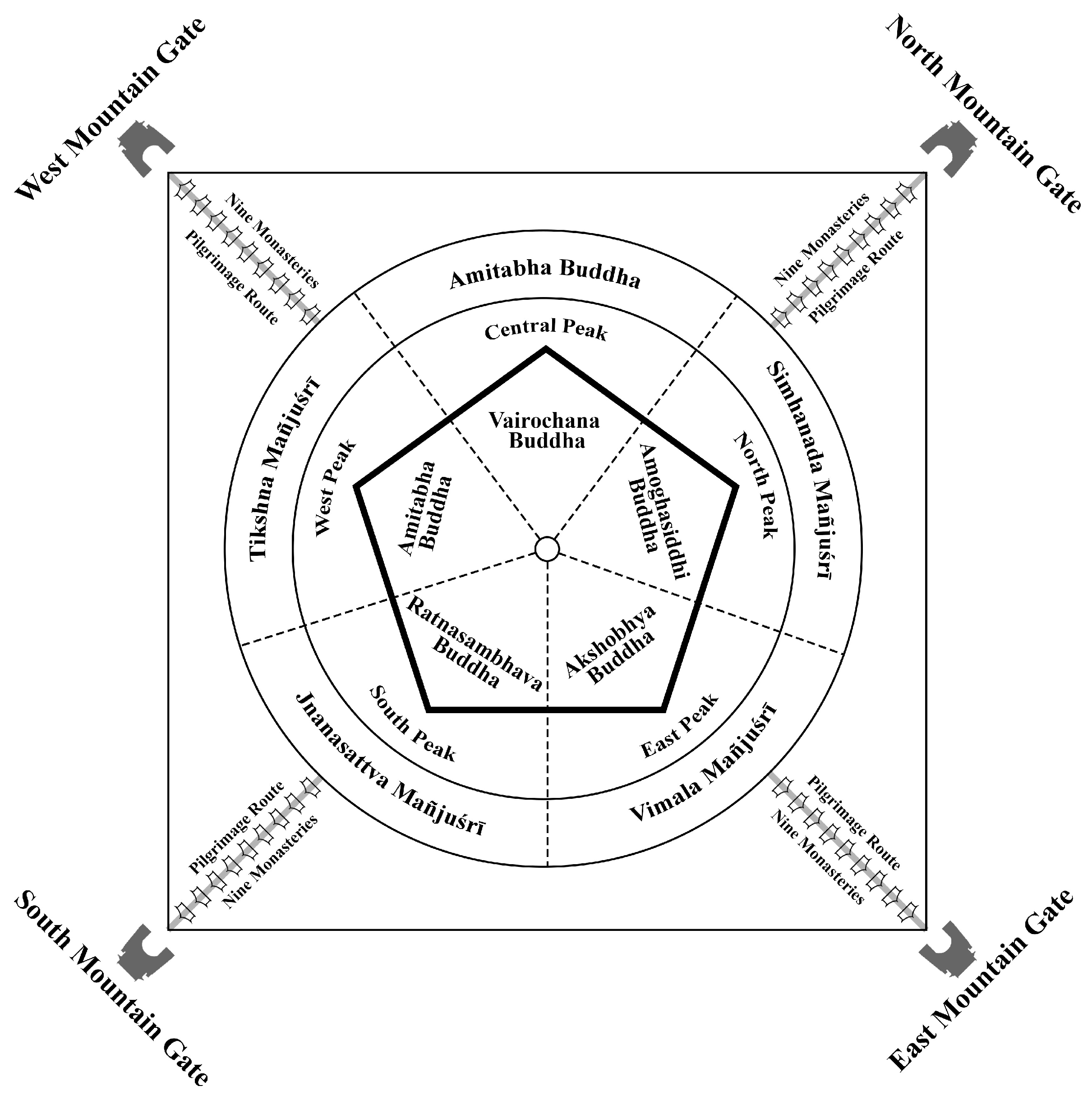
The emergence of esoteric Buddhism also symbolizes the birth of a new formulation: it continues to use complicated maṇḍalas and consists of royal consecrations, in which the practitioner is instructed to imagine themselves in a sacred field of the Buddha (
Davidson 2002). The most important type of image used in esoteric Buddhism is maṇḍala (
Birnhaum 1983). The term ‘maṇḍala’, from the Sanskrit, ‘specifically refers to the state of enlightenment illustrated by a graphic representation’ (
Kiyota 1968). The maṇḍala is considered a Buddhist cosmic model and emphasizes that the Buddha’s abode is in the center of the universe (
Xu 2010). In addition, the concept of the ‘maṇḍalization’ of geographical space is that ‘two-dimensional maṇḍala diagrams (both horizontally and vertically) expanded into three-dimensional sculptural and also were fully employed in concrete architectural space, influencing even the evolving levels of ritual understanding’ (
Malandra 1993). The maṇḍala paradigm is thought to offer a metaphor associated with the construction of stūpas for earthly kingship that reflect a celestial order and also contribute a sacred model for the realization of political ideology (
Chemburkar 1990;
Dellios 2019). The maṇḍala paradigm is also thought of as being a cosmic model that is used to systematize the Tibetan Buddhist landscape in China. The maṇḍala of esoteric Buddhism was also embodied in the Mañjuśrī cult.
6.1. Centralization of Mañjuśrī through Monastic Setting in Core Zone
Although Mount Wutai had been associated with Mañjuśrī since the Northern Wei Dynasty, it was not generally confirmed as the sacred dwelling place of Mañjuśrī until the Tang Dynasty. Mañjuśrī, known as the personification of wisdom and kindness in Mahāyāna sūtra text, represents sacred wisdom and assumes multiple roles. The Pusading Monastery (also known as Great Mañjuśrī Monastery, and Mañjuśrī Bodhisattva Real Body Monastery),
12 was initially built by Emperor Xiaowen of Northern Wei, but was rebuilt by Monk Fayun and was highly valued during Tang Dynasty. In
Shanxi Tong Zhi of Emperor Yongzheng,
‘monk Fayun asserted that he saw an apparition of Mañjuśrī Bodhisattva (real body) in the sea of clouds of Mount Wutai due to the prayers he offered to the Bodhisattva. Therefore, he reported this incredible sacred scene to the court and gained permission to construct a great Mañjuśrī Hall in Pusading Monastery in 763 CE. The ruling family invested heavily in this project; the Mañjuśrī Hall was even decorated with copper tiles and a gilded Mañjuśrī statue. Furthermore, as Buddhism became to advocate vigorously by the Emperor Shunzong’s reign (761–806 CE), as many of the essential ministers of the Imperial Court were devout Buddhists; even the Emperor Daizong of Tang (726–779 CE) was an adherent who believed in Buddhism, to the extent of giving up his original beliefs in Taoism.
Mount Wutai then became rapidly identified as the Mañjuśrī Bodhimaṇḍa (the abode of Mañjuśrī) with the construction of Mañjuśrī Hall at Pusading Monastery (also referred to as the Great Mañjuśrī Monastery) by the Tang Imperial Court (618–907 CE).
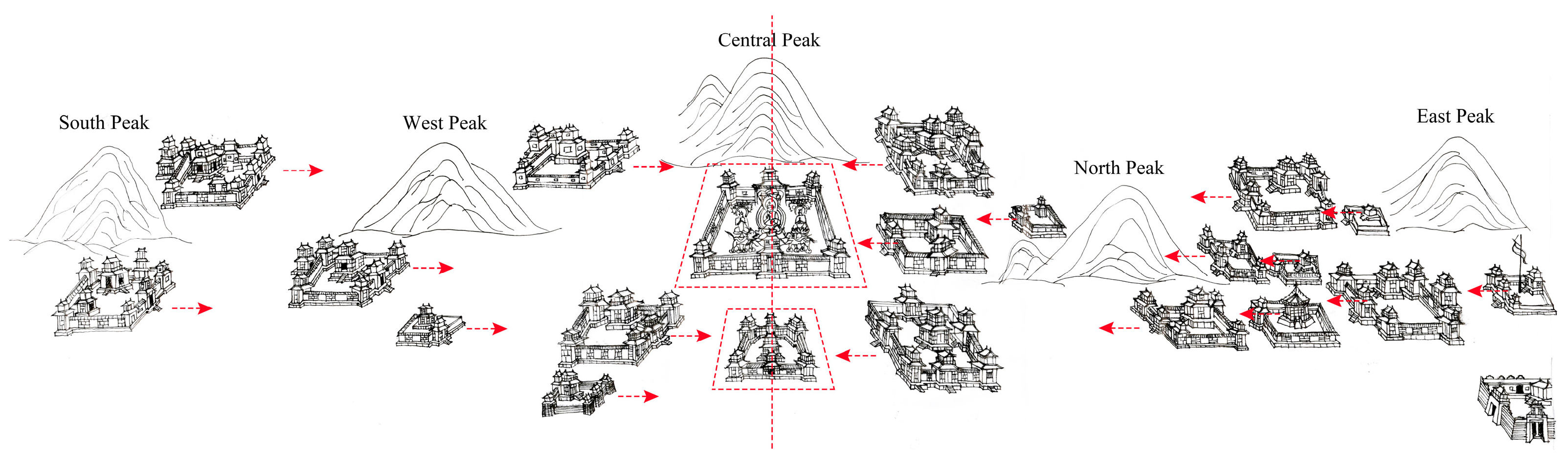
The Mañjuśrī monastery was a center of the overall landscape of monasticism on Mount Wutai. Although the Mañjuśrī Monastery has been rebuilt numerous times, its location on the top of Lingjiu Hill at the foot of Central Peak has not changed over the centuries, illustrating the particular religious significance of Mount Wutai. Indeed, this identification of the Mañjuśrī dojo has driven the religious landscape, monasticism, and Buddhist rites on Mount Wutai. The fresco information on Cave 61 of the Dunhuang Grottoes built in the Five Dynasties (907–979 CE), gives the orientation of these monasteries as all facing towards the center, the central monastery—the hall of the true body of the great sage Mañjuśrī, although their actual orientation at that time might not be the same as represented on the fresco (
Figure 3).
Although the Five Dynasties was the first historical period after the downfall of the Tang Dynasty, the grandeur of the murals in Cave 61, the numerous monasteries, the five visible peaks, and the Mañjuśrī Temple situated in the central platform could not have been suddenly constructed during the Five Dynasties. Their existence is undoubtedly a legacy left behind by the Tang Dynasty’s devotion to Buddhism. This deliberate arrangement stresses the importance of the Mañjuśrī Monastery, placing it at the center of the fresco and dominating the orientation of all the monasteries in this painting. When compared to the layout of early monasteries in India, it seems that there was no consistent regulation requiring Mañjuśrī Monastery to be positioned at the center of Buddhists. However, the frescoes depicting Chinese monasteries provide a unique emphasis on the significance of the Mañjuśrī cult on Mount Wutai. The method of monastic orientation employed, thus, exemplifies the integration of Chinese culture, is characterized by a centripetal tendency, and is reflected by the centralization of Mañjuśrī. It brings diverse regions and populations under a common Chinese identity and centralized governance (maintaining the integrity and unity of the nation) into Buddhist practices, reflecting the intricate tradition of architectural orientation that is deeply rooted in Chinese architectural heritage. The painting of the monasteries on Mount Wutai also indicates the cultural integration of ‘Bud–Chin’ culture.
Since the Mañjuśrī monastery was built during the Tang Dynasty on the summit of Lingjiu Hill and was identified at the foot of the central peak, the other four peaks had to be on either side of it. This is also the scenario seen in many of the visible archives of Mount Wutai. This reflects the early Buddhist cosmology for the systematic construction of a Buddhist landscape. The time when Mañjuśrī dwells on Mount Wutai in China is referred to as the ‘dissolution of dharma’ (mo-fa, 末法) and represents a time of spiritual turmoil (
Birnhaum 1984). However, this also underlines the importance of Mount Wutai, which has become a sacred place for Buddhists who might seek confirmation and affirmation of their faith through pilgrimage to Mount Wutai (
Birnhaum 1984). Therefore, Mount Wutai gradually transformed from a traditional Chinese mountain into a non-indigenous Buddhist cultural site.
The Five Peaks were regarded as the ‘Five Wisdom Tathāgatas’s throne’ and ‘five hair knots of Mañjuśrī Bodhisattva’
13 (
Chen 1726). Buddhist teachings on the characteristics of the Bodhisattva of Wisdom note: the five small knots are evenly distributed on the Bodhisattva’s head at the front, back, left and right, and in the middle. The five knots represent the five syllables of a Sanskrit invocation used in the worship of the Bodhisattva of Wisdom, where each syllable has a different meaning and can help the worshipper gain certain benefits. The establishment of Mount Wutai as the abode of the Mañjuśrī Bodhisattva signifies the beginning of geo-systematic monasticism, which is also manifested in the foundation of the first monastery with the syllable of the Mañjuśrī Bodhisattva.
6.2. Elements at the Buffer Zone in the Esoteric Mañjuśrī Maṇḍala
The structure of shaping Mount Wutai was characterized by its mountain gates, pilgrimage routines, five peaks, and the abode of Mañjuśrī Bodhisattva, supported by imperial patronage. These elements form an esoteric framework for the mountain’s significance. The diary of the visiting Japanese Buddhist Ennin who recorded his journey to worship Mount Wutai during the Tang Dynasty, and various historical records from Mount Wutai, provides a rich resource to track the possible pilgrimage routes that existed in medieval China.
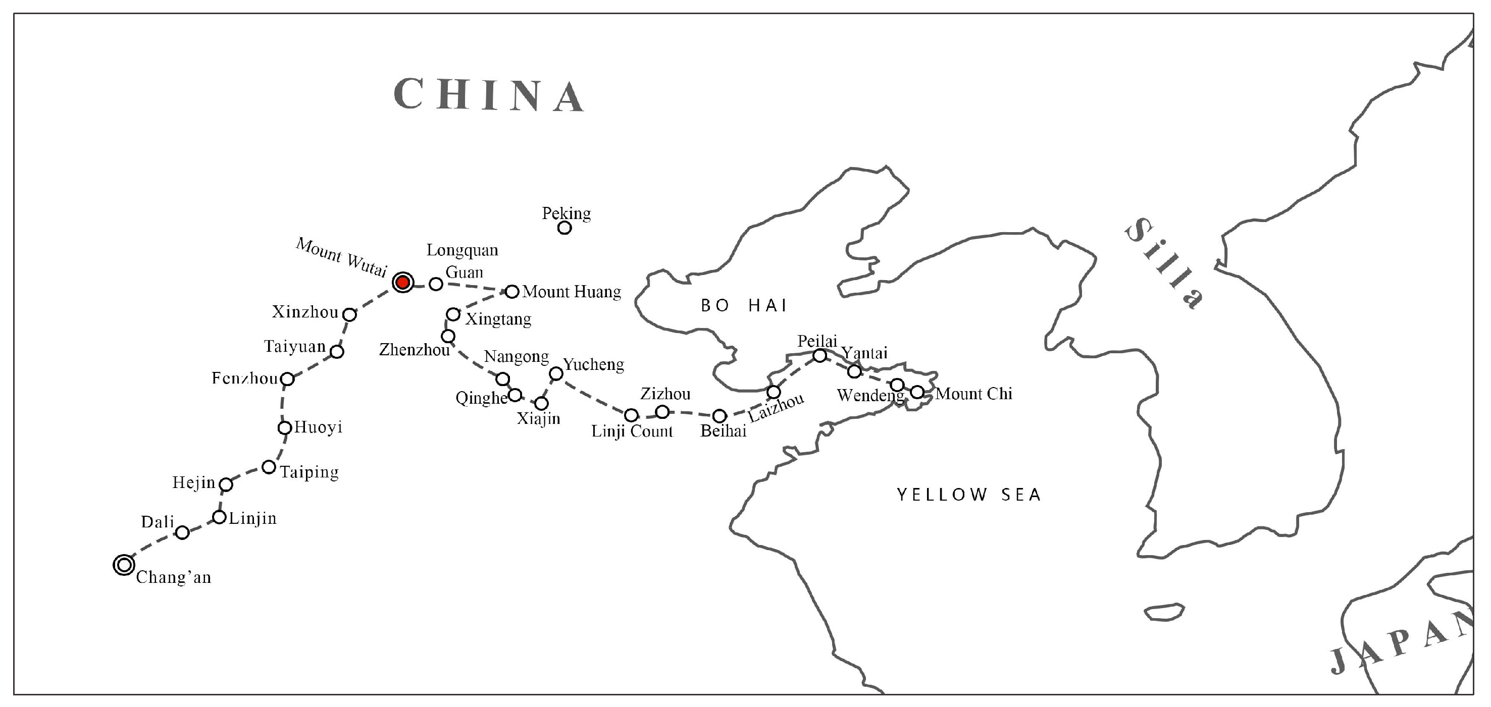
According to
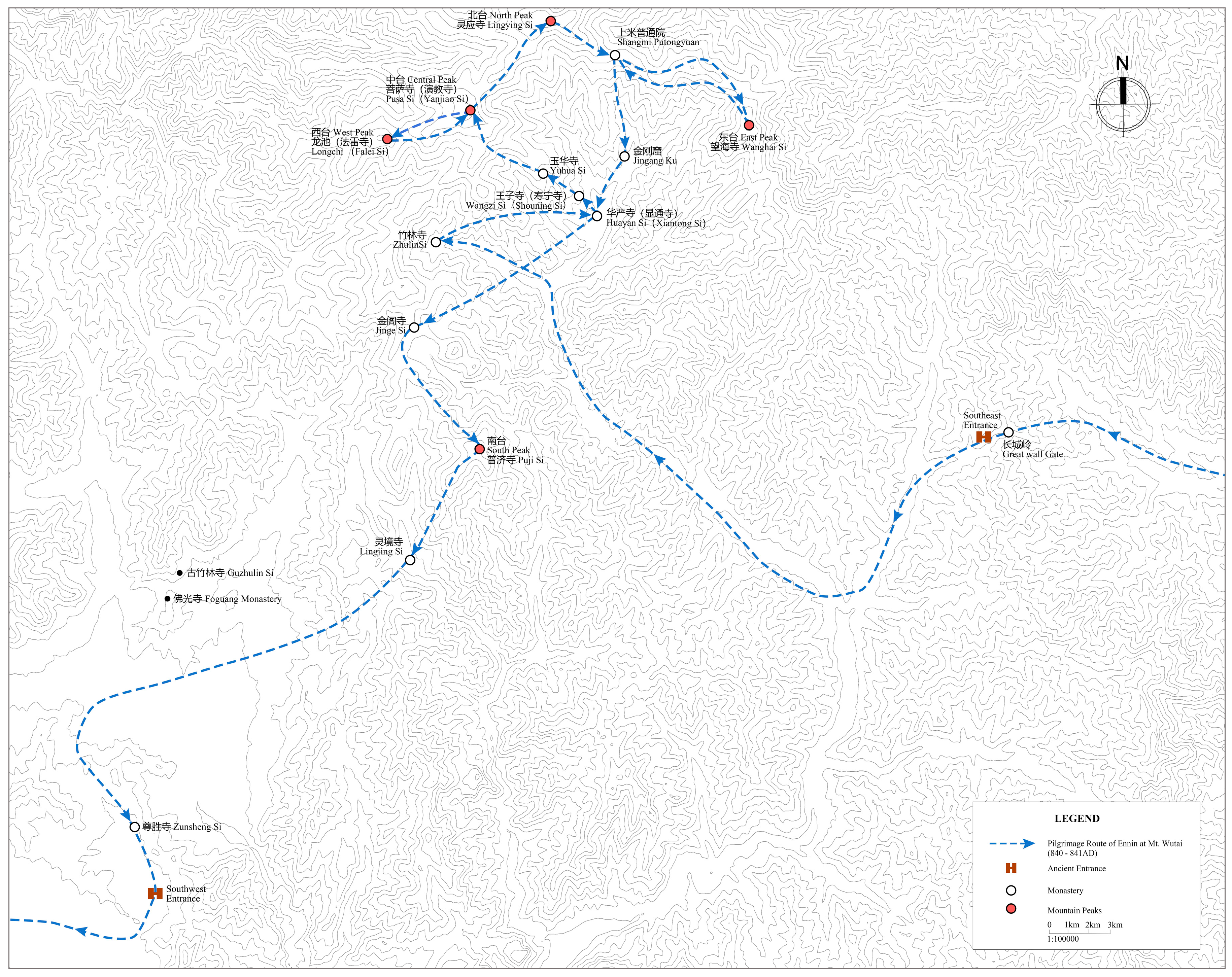
The Record of a Pilgrimage to China in Search of the Law by Ennin (838–845 CE), when Ennin first came to China by ship from Japan, he learned and practiced Buddhism at the Fahua Monastery at Mount Chi (during the Tang Dynasty). When he decided to go on pilgrimage to Mount Wutai and received his travel permit ‘Du Die’, he left Fahua Monastery in Mount Chi in 840 CE and finally reached Mount Wutai in 841 CE. The pilgrimage route leading from Shandong, through Hebei to Mount Wutai, was not explored by Ennin himself but was very familiar to other local pilgrims who familiarized Ennin with its details. Ennin learned that the long distance from Mount Chi to Mount Wutai was 2990 li (approximately 1495 km) (
Figure 4).
The trek to Mount Wutai via the east entrance was thus Ennin’s first choice as he set out from the Middle East shrine of China—Mount Chi in Shandong. During his long journey, with the exception of sleeping in peasants’ houses or monasteries along the road at night, he often stayed at ‘Putong Yuan’, a place where visiting pilgrims could stay, usually for just a short time; sometimes, Putong Yuan provided free meals for monks during the Tang Dynasty. The royal family built imperial palaces as places of rest on their pilgrimages, which usually took place in the seventeenth to nineteenth centuries (
Figure 5).
In a Putong Yuan close to the southeast approach to Mount Wutai, Ennin met many pilgrims and recorded various stories about them. At Guoyuan Putong Yuan (or Orchard Court), he once saw a large pilgrimage tour with more than 100 pilgrims returning from Mount Wutai, including patrons, nuns, and women. Ennin also frequently saw Buddhists from Jinge Monastery, which lies to the west of Mount Wutai, going to Shenzhou (near present-day Hengshui in Hebei) to ask for alms oil. It is therefore certain that the east passage to Mount Wutai was already in use during the Tang Dynasty, and the pilgrimage network and interaction of Buddhists allows for the possibility of several exits leading to Mount Wutai. Moreover, according to the geographical description provided by Ennin, the Putong Yuan of Longquan (the Dragon Spring site) was located near the Longquan Gate (or the Great Wall Gate), east access to Mount Wutai in the Tang Dynasty. Due to the Great Wall initially being built during the Ming Dynasty (1368–1644 CE), as the boundary of Mount Taihang and Mount Wutai, it has different names, but of course remains in the same location. Therefore, the southeast mountain gate that existed during the Tang Dynasty was later rebuilt as a Great Wall Gate in the Ming Dynasty.
Foguang Monastery was not actually visited by Ennin because of its location, as he did not have to pass by it. After leaving the border of Mount Wutai through the southern mountain gate, Ennin left Shanxi, crossed the Yellow River again, and finally returned to Chang’an, the capital during the Tang Dynasty. His journey up to that point had been some 1100 km but it was not yet over. Therefore, the existence of the south and east accesses during the Tang Dynasty can be confirmed by Ennin’s pilgrimage.
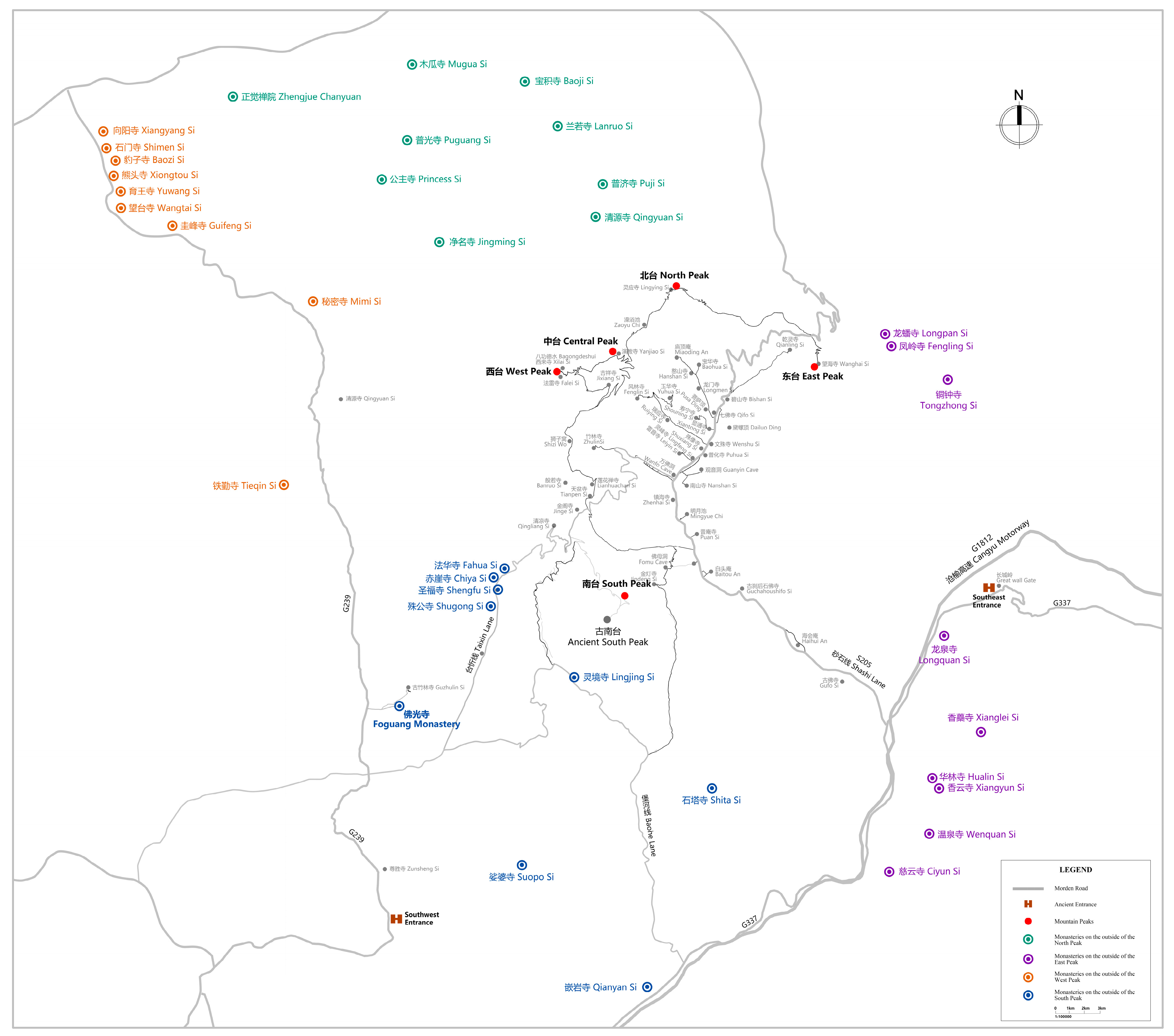
Apart from the ancient south access and east access routes, two other access routes (North and West) were developed during the Tang Dynasty. In
Qing Liang Shan Zhi,
‘there were more than two hundred monasteries at Mount Wutai and its surroundings, and taxes from eight provinces were allocated to meet the needs of sustaining Buddhists … each peak had nine monasteries that were located beyond the core scope of Mount Wutai but that were adjacent to the peaks’.14
Based on the text and the original construction date of these monasteries beyond the core area, it can be speculated that Mount Wutai was shaped by an esoteric maṇḍala model by defining the geographical placement of the monasteries.
There were thirty-six monasteries located beyond the core area. Situated outside the Five Peaks, these monasteries played a significant role in facilitating the pilgrimage routes. Monasteries originally built during the Tang Dynasty and located near the South and East Peaks provide evidence of the existence of these two routes. Additionally, outside the North Peak, the Tang Dynasty rulers sponsored the original construction of monasteries, such as Puji Monastery, Jingming Monastery, and Lanruo Monastery, indicating that the northern approach was still in use during the Tang Dynasty. In each peak, there were monasteries (or a monastery) originally built during the Tang Dynasty, suggesting that access could be obtained from each of the four peak’s directions (
Table 1,
Figure 6).
Of particular importance, outside the West Peak, all nine monasteries in the historical records were originally built during the Sui and Tang dynasties, demonstrating the importance of the western access during the Sui and Tang periods. A monastery called Wangtai Monastery, which means ‘view the peaks of Mount Wutai’ in Chinese, also reveals that there used to be a pilgrimage route to Mount Wutai from the west, but due to there being no further information about the construction or restoration of these monasteries after Sui and Tang dynasties, the west access was gradually abandoned.
In summary, from the four access points from four directions, four mountain gates, and nine monasteries before entering through the gates, we see that all served to guide visitors walking towards the core religious center at Mount Wutai. This deliberate arrangement also represented the religious meaning of monasticism on Mount Wutai, which was probably influenced by the esoteric maṇḍala model that concentrated on the sacred diagram (
Figure 7). The popularity of esoteric Buddhism during the Tang Dynasty in China would strengthen the concept of the maṇḍala paradigm; the visualization of the Mahāvairochana Buddha maṇḍala was also highly likely to provide a structural framework for Buddhist practice, whether in cave sculptures, monuments, architecture, or even in mountains.
Representing esoteric Buddhism, Jinge Monastery, located in the core area of Mount Wutai, provides an additional possible context for this monastic geography. Jinge Monastery was erected in 770 CE by the disciples of Amoghavajra, who successfully persuaded the Emperor to approve the construction (
Wang and Cui 2000). Jinge Monastery, Qingliang Monastery, Huayan Monastery (Mañjuśrī Monastery), and the Fahua Monastery were the royal dojos or royal shrines of the Tang Dynasty, where Buddhist religious ceremonies were performed and prayers used to be offered for the country (
Wang and Cui 2000). In Ennin’s diary, he also notes that he visited Jinge Monastery and met with emissaries from the Imperial Court who were distributing royal patronages to the monasteries of Wutai Mountain. Jinge Monastery was an important stop for these emissaries. When the envoys arrived, all the monks at the monastery would go out to greet the emperor’s patronages. Every year, only twelve monasteries (the names of the monasteries were not mentioned by Ennin) at Mount Wutai were allowed to receive a large number of gifts from the Imperial Court, such as five hundred Buddhist robes made of fine silk, one hundred and fifty kilograms (500 tun) of cotton cloth, five hundred pieces (1000 duan, 500 pi, 3330 m) of cyan-blue Buddhist cassock cloth, fifty kilograms of incense, fifty kilograms of tea, and one thousand towels. When the ambassadors had completed their mission, they returned to the Jinge Monastery and then traveled directly back to the capital, Chang’an.
The Five Peaks and ‘ten great monasteries’
15 create a central and divine space accessible through four mountain gates from the north, south, west, and east, and the nine monasteries distributed outside each peak create a transitional space from the non-religious to the divine center (Mount Wutai). This order and arrangement convey the cosmology of the Buddhist maṇḍala, and the components such as the center, the peaks, the monasteries, the paths, and the gates represent the essential approaches for practitioners (planners or designers) to achieve the transformation of people’s concepts.
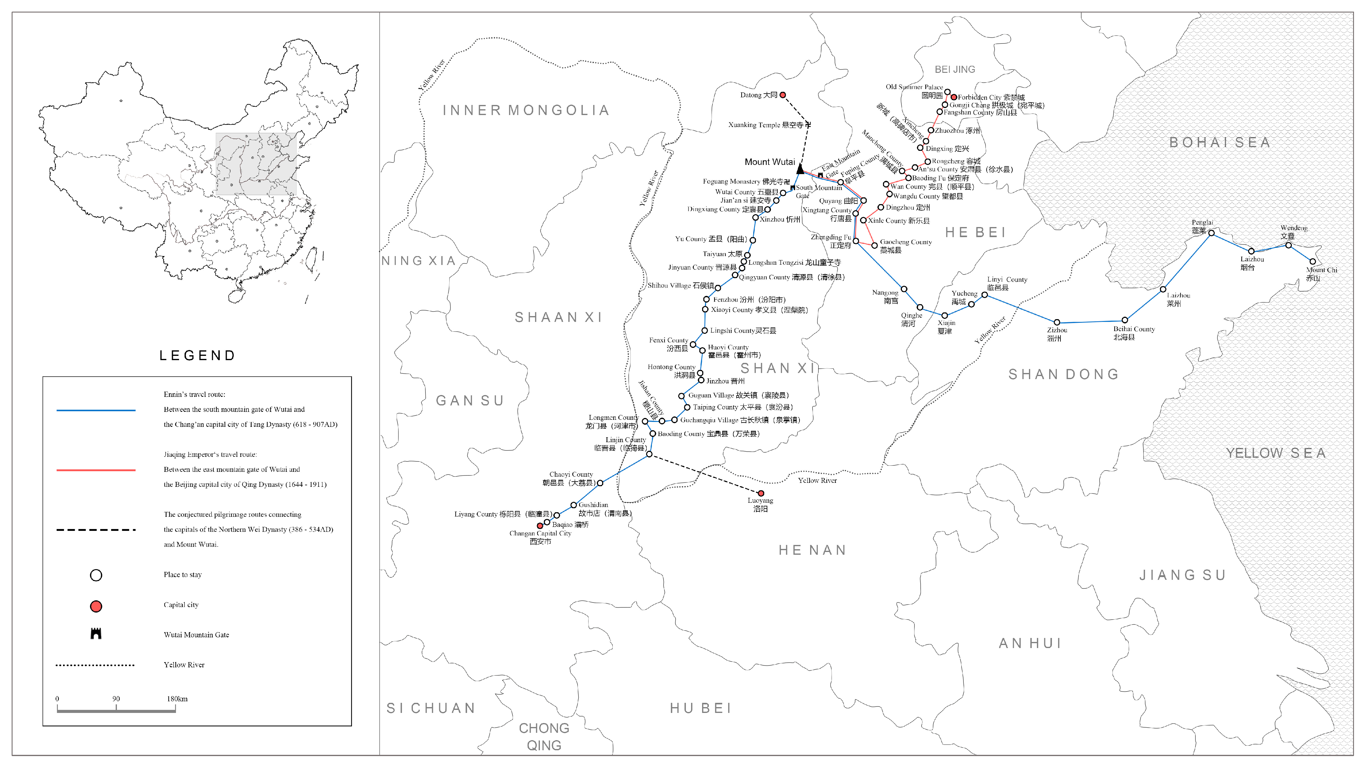
7. Repositioning the East Access of Mount Wutai as the Main Pass Following a Shift in the Political Center
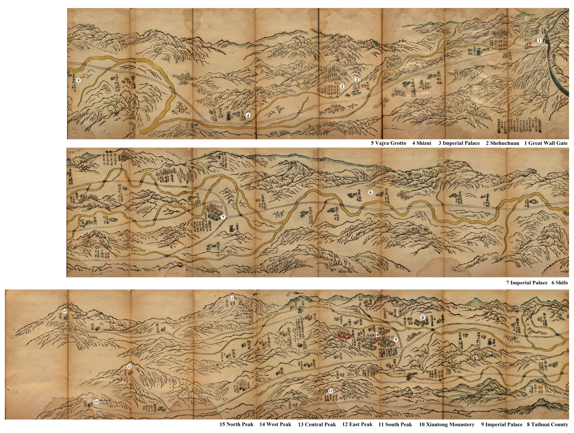
The archives about the roads on Mount Wutai in the nineteenth century provide information about the emperor’s pilgrimage from an easterly direction (the east Mount gate of the Great Wall) toward Mount Wutai. In addition, all these following ancient maps show the footpaths leading to each peak, as well as the names and locations of the monasteries that lie along each path. The mountain gate of Mount Wutai, which was under royal patronage because of the frequent pilgrimages there by the Qing emperors, marks the main entrance of sacred Tibetan Buddhist land during the Qing Dynasty, although the Great Wall Gate is no longer the present-day gate.
In the Qing Dynasty map in 1855, Mount Wutai was bound by the Great Wall from the east. This boundary is part of the Ming Great Wall, which was an 8851.8 km long wall built between 1368 and 1644 CE (
Wang 2009). In the historical text of
Ming Shilu, a small part of the Ming Great Wall running north–south extended to Mount Wutai, called Lonquan Guan (Guan in Chinese means gate tower, or called Great Wall gate), built between 1437 and 1451 CE (
Zhang et al. 1328–1627) (
Figure 8).
During the Ming Dynasty, Emperor Taizu was a monk before he became emperor through the peasant revolt; Emperor Chengzu appointed monks to be his strategists to govern the country; Peking, the capital during the Ming Dynasty, had more than 1000 monasteries, and monastic buildings were distributed throughout the entire city (
Guo 2006). During the Ming Dynasty, Chinese Buddhism flourished under the substantial support of the ruling elite, including the political class. Geographically, Longquan Guan lies 60 miles to the south of Mount Wutai and formed the border between the Zhinu and Shanxi regions during the Ming Dynasty; to the east is Zhinu, the region’s prefecture, which was directly administered by the central government of the Ming Dynasty, while to the west is the Shanxi region, where Mount Wutai is located.
16Another historical map of Mount Wutai in
Qing Liang Shan Zhi (1546–1617 CE) (
Figure 9) shows the mountain’s geographical relation with the adjacent counties, the Hutuo River surrounding Wutai outside the core zone, the locations of monasteries or Buddhist monuments in the Mount Wutai region, and indicates the South Access passage there. Moreover, the paths in the map also show the possible historical pilgrimage in the Qing Dynasty. To worship the Five Peaks without turning back, the route could start at the road junction near Jiao Kou on the contemporary map and then climb up to the South Peak. The South Peak is actually a junction that led to three different destinations. Visitors to South Peak could either reach the Ancient South Peak directly, or go down via the Jinge ridge to Qingliang Stone and then to the Lion’s Cave; or they could go down to Jiulong Gang, pass Zhulin si (or Bamboo Monastery), and reach the Lion’s Cave. They could then cross Qingliang Bridge and walk to the West Peak, then Center Peak. A path near the Zaoyu Chi (Bodhisattva bathing place) connected the Center Peak and the highest peak then extended to the last peak, which is the same route that visitors take today. The mountain gate (or Great Wall gate, Longquan Guan) in the Great Wall ridges is the only eastern entrance to Mount Wutai referred to on the map.
Furthermore, the Great Wall Gate is also marked on the historical map in 1850 CE of the Qing Dynasty (
Figure 10). The map points out the names and locations of monasteries, villages’ roads, and rivers in Mount Wutai scope, and also includes the exact positions of imperial palaces and the precise distance between resting places. The function of this map was to serve for the emperor’s pilgrimage to Mount Wutai, and the Great Wall Gate acted as the mountain access for the imperial family. There are three imperial palaces after passing through the Great Wall Gate. The first palace past the Great Wall Gate is (in Tailu si) near the Shehuchuan (In 1683 CE, Emperor Kangxi visited this place, where he encountered and successfully hunted a tiger. This remarkable event was commemorated with a stone tablet erected at the site); the second is close to present-day Baiyun si (or Jiaokou); and the third is in Taihuai village, near Xiantong Monastery. Moreover, this map does not show the circuit path and there is no path between Center Peak and North Peak; rather, it shows a number of parallel paths. Specifically, there is only one passage from the mountain gate to the first imperial palace. After the first palace, there are three branches leading to different destinations. One path leads to the South Peak and the ancient South Peak, another leads to Qingliang Monastery and Qingliang Stone, which one can also take to reach Taihuai village, while the third goes directly to Taihuai village, where the second palace is also located.
Among all the pilgrimage maps of Mount Wutai mentioned earlier, the Great Wall served as the sole primary access to the mountain region during the Qing Dynasty. Geographically, Long Quan Guan is the closest place to the capital of Beijing. Peking is known to have been the capital during the Liao Dynasty (916–1125 CE), the Jin Dynasty (1115–1134 CE), the Yuan Dynasty (1271–1368 CE), the Ming Dynasty (1368–1644 CE), and the Qing Dynasty (1636–1912 CE), that is, for more than eight hundred years, and the majority of rulers during this time were adherents to Buddhism. For instance, in the Liao and Jin dynasties, as Buddhism prevailed, numerous Buddhist buildings were erected, many of which remain today, such as the Guanyin Pavilion of the Dule Pagoda in Ji County, Tianjin city, and the Shakyamuni Pagoda at Fogong Monastery in Ying County, Shanxi Province. During the Yuan Dynasty (1271–1368 CE), Tibetan Buddhism impacted the Buddhist arts, involving mainly statues and architecture. With the introduction of Tibetan Buddhism, Tibetan monastic architecture was also first introduced on Mount Wutai, where Chinese and Tibetan Buddhism then coexisted, and Mount Wutai became a common holy place for both Chinese and Tibetan Buddhists (
Lu 2016). The mountain gate on the Great Wall was thus to be used for a very long time, not only during the Qing Dynasty, and the capital Beijing undoubtedly determined its popularity. The imperial family undeniably felt the need to conveniently open this eastern entrance for pilgrimages and imperial patronage. However, this does not mean that the Great Wall Gate was the only entrance to the mountain in history.
However, the south access of Mount Wutai in the Qing Dynasty, which also existed in the nineteenth century, is missing from many visual maps, which only highlights the Great Wall Gate (or Long Quan Guan). At the rear of the South Peak, Foguang Monastery and the Ancient Bamboo Monastery, as indicated in Chinese characters, occupy the same geographical locations as described by Ennin and as seen in the current situation (
Figure 11). The Ancient Bamboo Monastery is marked on the map near the Foguang Monastery. At present, Ancient Bamboo Monastery is 1500 m away from Foguang Monastery (
Figure 2). The Count of Wutai marked on the map is also near Foguang Monastery and Ancient Bamboo Monastery. It should be noted that the two monasteries have long been administered by Wutai County and have nothing to do with Mount Wutai. Most importantly, the map between Wutai County and Foguang Monastery shows a mountain gate, which should be the south access to Mount Wutai. This is because if visitors go through the gate in the direction of Foguang Monastery and Ancient Bamboo Monastery, they will enter a valley leading to Mount Wutai. The reason why the south entrance is not mentioned in most of the fourteenth to nineteenth-century archives is not entirely clear. However, the most convincing explanation might be that after the Tang Dynasty, when the capital shifted from Chang’an to Beijing, the gate lost much of its former popularity.
In the nineteenth century, Mount Wutai epitomized a syncretic phenomenon, characterized by the convergence of diverse Buddhist cults and various monastic stations, including Qing Miao and Huang Miao. Teeming with pilgrims and visitors, it presented a dynamic contrast to the unchanging Five Peaks. This amalgamation fostered the emergence of a new, hybrid Buddhist center, distinct from the esoteric Buddhism of the medieval period that shaped the sacred maṇḍala landscape.
Although it is difficult to restore all routes during different historical periods, royal pilgrimages and offerings must be the most influential in history, so the road connecting the Imperial City with Mount Wutai and the gate of Mount Wutai facing the capital would naturally have been the most accessible (
Figure 12). In the medieval period, this echoes the purposeful creation of a central divine space via the positioning of the Five Peaks, ten great monasteries create a central and divine space accessible through four mountain gates from the north, south, west, and east, and nine monasteries distributed outside each peak create a transitional space from the non-religious to the divine center (Mount Wutai). This order and arrangement convey the cosmology of the Buddhist maṇḍala, and the components such as the center, the peaks, the monasteries, the paths, and the gates represent the essential approaches for practitioners (planners or designers) to achieve the transformation of people’s concepts. From the description of the monasteries located beyond the east peak, it appears that two monasteries were built subsequent to the Tang Dynasty, and that five have no descriptions about their histories, only brief locational information. This may be because the monasteries were first constructed by general funders during the Qing Dynasty and have no glorious historical backgrounds or legends about famous monks associated with them. However, when the capital was moved from Chang’an to Beijing subsequent to the Tang Dynasty, this shift promoted the popularity of the southeastern route to Mount Wutai and, of course, also boosted the development of monasteries along the corresponding pilgrimage route.
8. Conclusions
The monumental Buddhist architecture and culture accumulated over more than a thousand years on Mount Wutai created a splendid dynamic showcase for the development of Buddhist dharma, the faith of Buddhism, the sinicization of Buddhist culture (or the religious interaction between China and other countries on the Silk Road and Chinese tradition), and religious–political interaction. The pilgrimage routes through the monasteries leading to Mount Wutai operate as a dynamic and multifaceted system that fosters a range of religious activities and interactions. As such, they represent an important aspect of religious culture and tradition, facilitating the exchange of ideas and beliefs while promoting social culture and architectural growth.
In addition, the design of the monastic geography of Mount Wutai in medieval China was probably shaped by the visualization of the Mañjuśrī maṇḍala, which incorporated esoteric Buddhism and the Mañjuśrī cult. In this vast network, Foguang Monastery was essentially inconspicuous. As a stopover, it was located on the southern pilgrimage route to Mount Wutai. However, Foguang Monastery, and another 35 monasteries outside the religious core area of Mount Wutai and the four mountain gates, successfully led pilgrims to the religious center (the pure land symbolizing the Mañjuśrī Bodhisattva. The shift in location of political capitals led to the paths of the pilgrimage routes to Mount Wutai being somewhat dynamic. The route that passed by Foguang Monastery gradually fell out of favor as the route to the circumambulation of the Five Peaks no longer began to the south but to the east, namely, at the gate of the Great Wall Gate. During the medieval period, the Five Peaks and the Ten Great Monasteries constituted a central and sacred space, accessible through four mountain gates in the north, south, west, and east. The nine monasteries surrounding each peak created a transitional zone bridging the secular and the divine center, Mount Wutai. This arrangement mirrors the cosmology of the Buddhist maṇḍala, with its central elements—the center, peaks, monasteries, paths, and gates—offering essential avenues for transformation in the minds of practitioners, including politicians, planners, and Buddhists.


