
On the Duality of Marine Geoheritage: Evidence from the Abrau Area of the Russian Black Sea Coast


Abstract
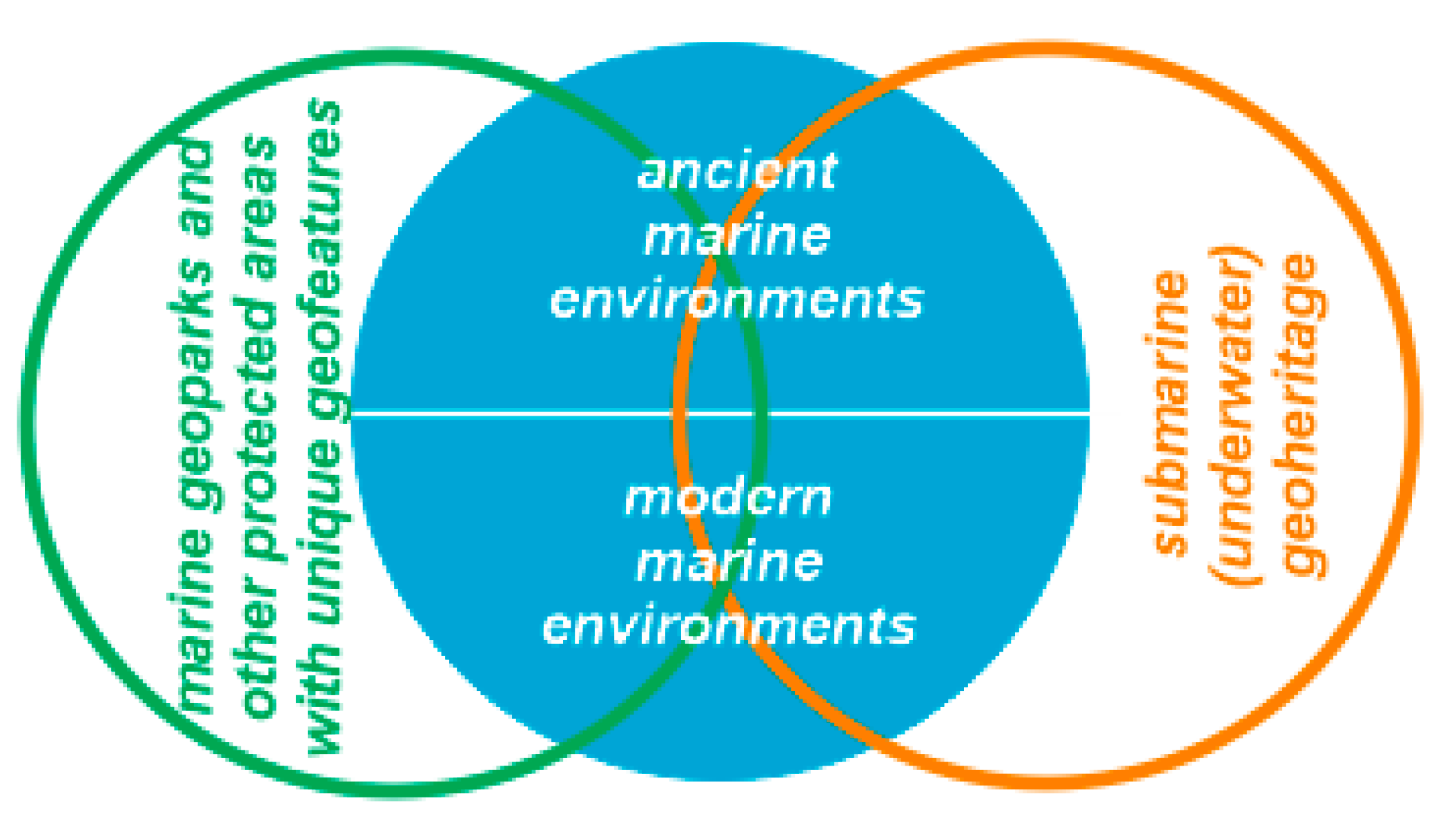
:1. Introduction
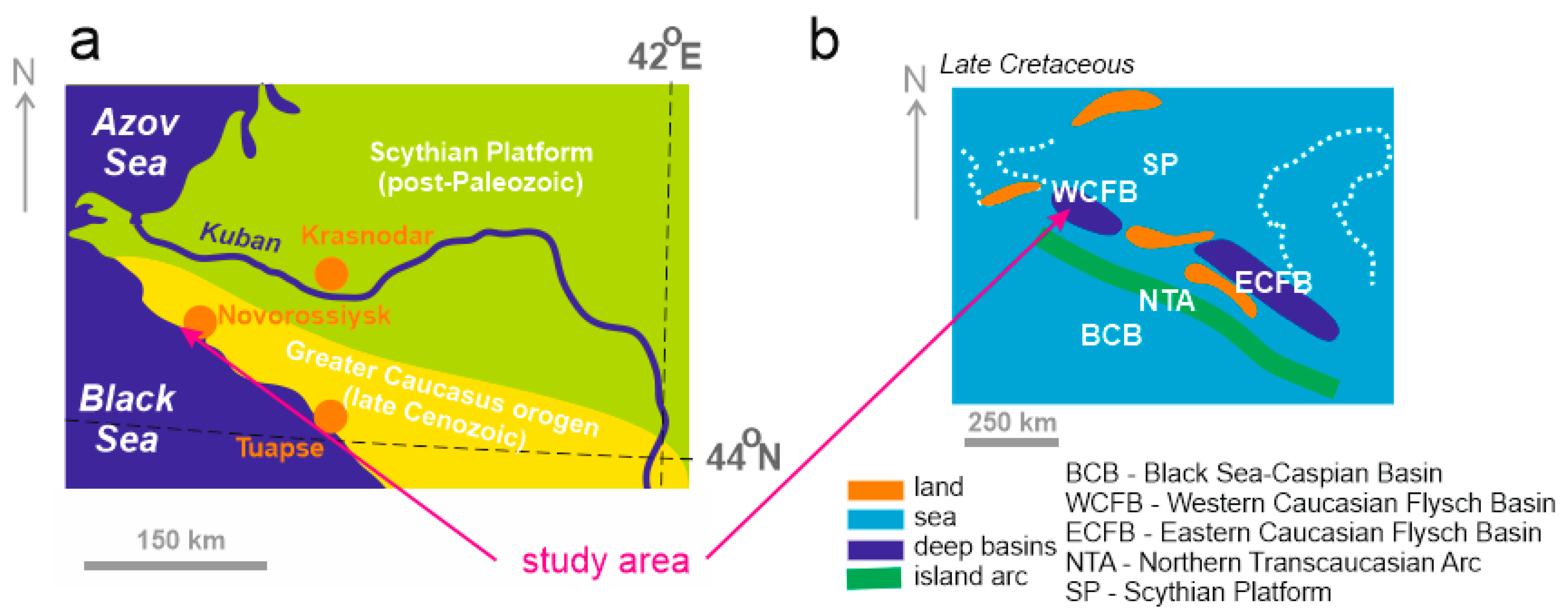
2. Geological Setting
3. Methodology
4. Results
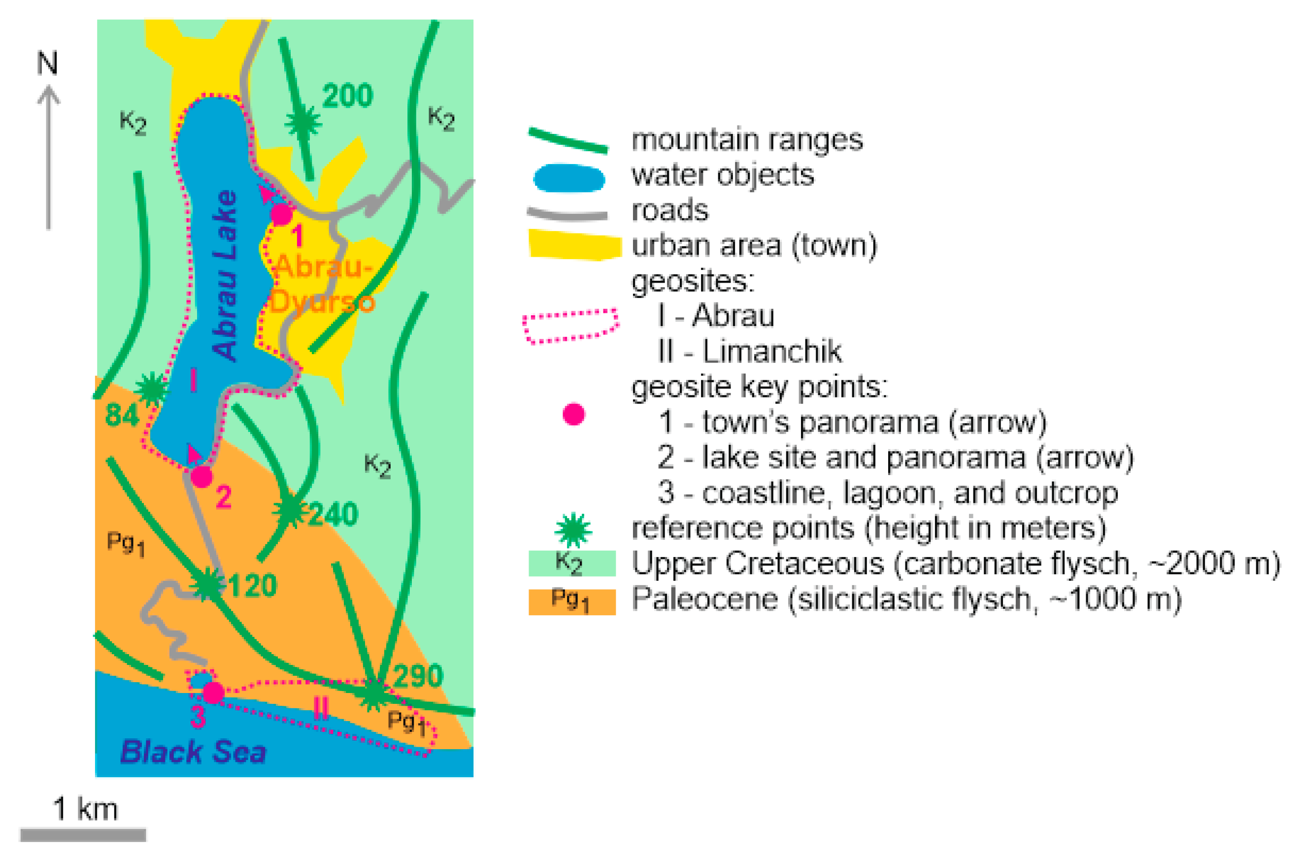
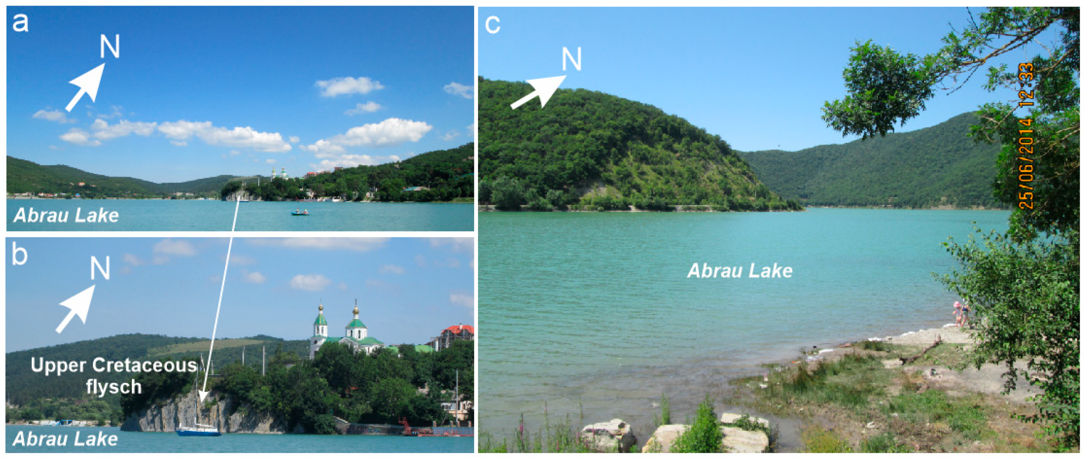
4.1. The Abrau Geosite
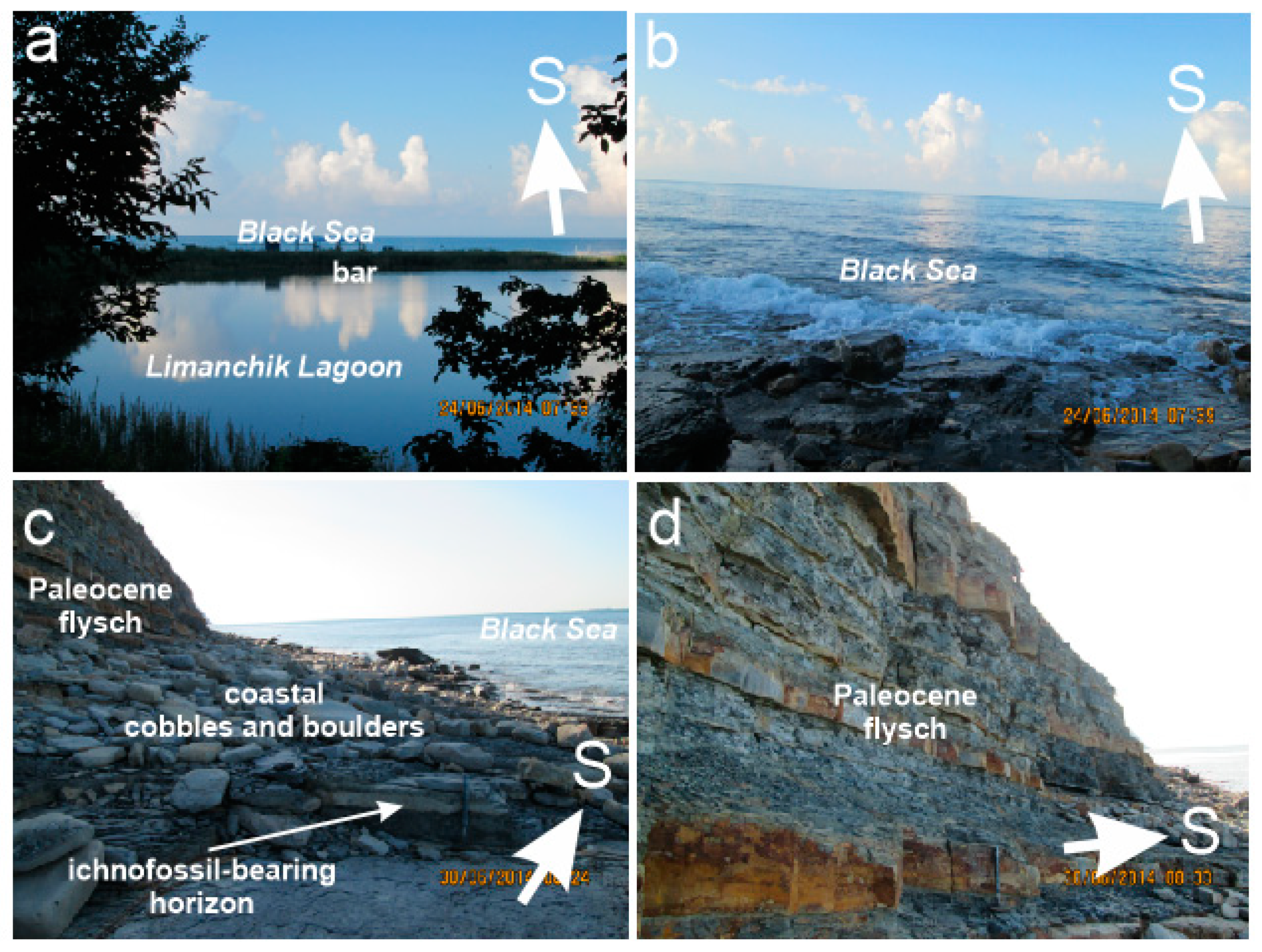
4.2. The Limanchik Geosite
4.3. The Abrau Area
5. Discussion and Conclusions
Funding
Institutional Review Board Statement
Informed Consent Statement
Data Availability Statement
Acknowledgments
Conflicts of Interest
References
- Brocx, M.; Semeniuk, V. Geoheritage and geoconservation—History, definition, scope and scale. J. R. Soc. West. Aust. 2007, 90, 53–87. [Google Scholar]
- Coratza, P.; Reynard, E.; Zwolinski, Z. Geodiversity and Geoheritage: Crossing Disciplines and Approaches. Geoheritage 2018, 10, 525–526. [Google Scholar] [CrossRef] [Green Version]
- Crofts, R.; Tormey, D.; Gordon, J.E. Introducing New Guidelines on Geoheritage Conservation in Protected and Conserved Areas. Geoheritage 2021, 13, 33. [Google Scholar] [CrossRef]
- Henriques, M.H.; Castro, A.R.S.F.; Félix, Y.R.; Carvalho, I.S. Promoting sustainability in a low density territory through geoheritage: Casa da Pedra case-study (Araripe Geopark, NE Brazil). Resour. Policy 2020, 67, 101684. [Google Scholar] [CrossRef]
- Németh, B.; Németh, K.; Procter, J.N.; Farrelly, T. Geoheritage Conservation: Systematic Mapping Study for Conceptual Synthesis. Geoheritage 2021, 13, 45. [Google Scholar] [CrossRef]
- Prosser, C.; Murphy, M.; Larwood, J. Geological Conservation: A Guide to Good Practice; English Nature: Peterborough, UK, 2006.
- Reynard, E.; Brilha, J. (Eds.) Geoheritage: Assessment, Protection, and Management; Elsevier: Amsterdam, The Netherlands, 2018. [Google Scholar]
- Coratza, P.; Vandelli, V.; Fiorentini, L.; Paliaga, G.; Faccini, F. Bridging terrestrial and marine geoheritage: Assessing geosites in Portofino Natural Park (Italy). Water 2019, 11, 2112. [Google Scholar] [CrossRef] [Green Version]
- Rovere, A.; Vacchi, M.; Parravicini, V.; Bianchi, C.N.; Zouros, N.; Firpo, M. Bringing geoheritage underwater: Definitions, methods, and application in two Mediterranean marine areas. Environ. Earth Sci. 2011, 64, 133–142. [Google Scholar] [CrossRef]
- Li, Y.; Chen, S.; Li, Y. The evaluation and development of the geoheritage landscapes in Dalian Jinshitan National Marine Park. Int. J. Geoheritage Parks 2018, 6, 63–74. [Google Scholar] [CrossRef]
- Gutak, J.M.; Ruban, D.A.; Yashalova, N.N. New marine geoheritage from the Russian Altai. J. Mar. Sci. Eng. 2021, 9, 92. [Google Scholar] [CrossRef]
- Chiba, S.; Saito, H.; Fletcher, R.; Yogi, T.; Kayo, M.; Miyagi, S.; Ogido, M.; Fujikura, K. Human footprint in the abyss: 30 year records of deep-sea plastic debris. Mar. Policy 2018, 96, 204–212. [Google Scholar] [CrossRef]
- Peng, G.; Bellerby, R.; Zhang, F.; Sun, X.; Li, D. The ocean’s ultimate trashcan: Hadal trenches as major depositories for plastic pollution. Water Res. 2020, 168, 115121. [Google Scholar] [CrossRef] [PubMed]
- Vescovo, V.L.; Jamieson, A.J.; Lahey, P.; McCallum, R.; Stewart, H.A.; Machado, C. Safety and conservation at the deepest place on Earth: A call for prohibiting the deliberate discarding of nondegradable umbilicals from deep-sea exploration vehicles. Mar. Policy 2021, 128, 104463. [Google Scholar] [CrossRef]
- Afanasyev, D.F.; Akatov, V.V. Effects of Cystoseira Sensu lato (Fucales: Phaeophyceae) on Species Richness, Composition, and Biomass of Abrau Peninsula Shelf Macrophytobenthic Communities (Black Sea). Oceanology 2021, 61, 244–253. [Google Scholar] [CrossRef]
- Kuznetsova, E.I. Juniper forests and woodlands of the abrau peninsula (the North-Western Caucasus). Geografiya 2009, 2, 76–80. [Google Scholar]
- Petrooshina, M. Landscape mapping of the Russian Black Sea coast. Mar. Pollut. Bull. 2003, 47, 187–192. [Google Scholar] [CrossRef]
- Alexander, D.V.; Danila, D.O.; Alexey, M.A.; Vyacheslav, M.V. Dolmens in the anthropogenic landscape of the Abrau Peninsula. Sib. Hist. Res. 2018, 3, 139–157. [Google Scholar]
- Shapenko, A.; Martynov, S. Abrau-Durso: Reviving the 140-year-old Russian wine brand. Emerald Emerg. Mark. Case Stud. 2020, 10, 1–23. [Google Scholar] [CrossRef]
- Baraboshkin, E.Y.; Bondarenko, N.A.; Lyubimova, T.V. Unique Geological Objects of the North-Western Caucasus; KubGU: Krasnodar, Russia, 2012. (In Russian) [Google Scholar]
- Karpunin, A.M.; Mamonov, S.V.; Mironenko, O.A.; Sokolov, A.R. Geological Monuments of Nature of Russia; Lorien: Sankt-Peterburg, Russia, 1998. (In Russian) [Google Scholar]
- Ruban, D.A. New findings of trace fossils of Paleocene marine organisms in the vicinities of Abrau-Dyurso (Krasnodar Region). Izv. Vyss. Uchebnykh Zavedenij. Geol. Razved. 2014, 6, 72–74. (In Russian) [Google Scholar]
- Adamia, S.; Zakariadze, G.; Chkhotua, T.; Sadradze, N.; Tsereteli, N.; Chabukiani, A.; Gventsadze, A. Geology of the Caucasus: A review. Turk. J. Earth Sci. 2011, 20, 489–544. [Google Scholar]
- Kaban, M.K.; Gvishiani, A.; Sidorov, R.; Oshchenko, A.; Krasnoperov, R.I. Structure and density of sedimentary basins in the southern part of the east-European platform and surrounding area. Appl. Sci. 2021, 11, 512. [Google Scholar] [CrossRef]
- Rolland, Y. Caucasus collisional history: Review of data from East Anatolia to West Iran. Gondwana Res. 2017, 49, 130–146. [Google Scholar] [CrossRef]
- Saintot, A.; Angelier, J. Tectonic paleostress fields and structural evolution of the NW-Caucasus fold-and-thrust belt from Late Cretaceous to Quaternary. Tectonophysics 2002, 357, 1–31. [Google Scholar] [CrossRef] [Green Version]
- Van Hinsbergen, D.J.J.; Torsvik, T.H.; Schmid, S.M.; Matenco, L.C.; Maffione, M.; Vissers, R.L.M.; Gürer, D.; Spakman, W. Orogenic architecture of the Mediterranean region and kinematic reconstruction of its tectonic evolution since the Triassic. Gondwana Res. 2020, 81, 79–229. [Google Scholar] [CrossRef]
- Lordkipanidze, M.B.; Adamia, S.A.; Asanidze, B.Z. Evolution of the active margins of the ocean Tethys (by example of the Caucasus). In Oceanology Reports: 27 International Geological Congress, 3; Lisitsin, A.P., Ed.; Nauka: Moscow, Russia, 1984; pp. 72–83. (In Russian) [Google Scholar]
- Kropotkin, M. Seismic impacts influence on the slope stability on the example of Abrau Peninsula (Russian sector of Black Sea coast). E3S Web Conf. 2020, 157, 02022. [Google Scholar] [CrossRef] [Green Version]
- Trikhunkov, Y.I.; Bachmanov, D.M.; Gaidalenok, O.V.; Marinin, A.V.; Sokolov, S.A. Recent Mountain Building at the Junction Zone of the Northwestern Caucasus and Intermediate Kerch–Taman Region, Russia. Geotectonics 2019, 53, 517–532. [Google Scholar] [CrossRef]
- Trikhunkov, Y.I.; Gaidalenok, O.V.; Bachmanov, D.M.; Marinin, A.V. Morphostructure of the junction zone of the North-Western Caucasus and the Kerch-Taman region. Geomorfologiya 2018, 4, 80–95. [Google Scholar]
- Yasamanov, N.A. Landscape-Climatic Conditions of the Jurassic, the Cretaceous, and the Paleogene in the South of the USSR; Nedra: Moscow, Russia, 1978. (In Russian) [Google Scholar]
- Kholodov, V.N.; Golubovskaya, E.V.; Nedumov, R.I. Origin and prospects of the Cimmerian iron ore basin in Ukraine and Russia. Lithol. Miner. Resour. 2014, 49, 359–380. [Google Scholar] [CrossRef]
- Popov, S.V.; Rogl, F.; Rozanov, A.Y.; Steininger, F.F.; Shcherba, I.G.; Kovac, M. Lithological-paleogeographic maps of Paratethys. Cour. Forsch. Senckenberg 2004, 250, 1–46. [Google Scholar]
- Popov, S.V.; Shcherba, I.G.; Ilyina, L.B.; Nevesskaya, L.A.; Paramonova, N.P.; Khondkarian, S.O.; Magyar, I. Late Miocene to Pliocene palaeogeography of the Paratethys and its relation to the Mediterranean. Palaeogeogr. Palaeoclimatol. Palaeoecol. 2006, 238, 91–106. [Google Scholar] [CrossRef]
- Rostovtseva, Y.V.; Kuleshov, V.N. Carbon and oxygen stable isotopes in the middle-upper Miocene and lower Pliocene carbonates of the Eastern Paratethys (Kerch-Taman Region): Palaeoenvironments and post-sedimentation changes. Lithol. Miner. Resour. 2016, 51, 333–346. [Google Scholar] [CrossRef]
- Ertekin, C.; Ekinci, Y.L.; Büyüksaraç, A.; Ekinci, R. Geoheritage in a Mythical and Volcanic Terrain: An Inventory and Assessment Study for Geopark and Geotourism, Nemrut Volcano (Bitlis, Eastern Turkey). Geoheritage 2021, 13, 73. [Google Scholar] [CrossRef]
- Naimi, M.N.; Cherif, A. Inventory and assessment of significant scientific Algerian geoheritage: Case of remarkable geosites from Orania (Western Algeria). Int. J. Geoheritage Parks 2021, 9, 13–29. [Google Scholar] [CrossRef]
- Phuong, T.H.; Cu, N.H.; Thanh, T.D.; Van Dong, B. Geoheritage values in the Cat Ba islands, Vietnam. Environ. Earth Sci. 2013, 70, 543–548. [Google Scholar] [CrossRef]
- Brilha, J. Inventory and quantitative assessment of geosites and geodiversity sites: A review. Geoheritage 2016, 8, 119–134. [Google Scholar] [CrossRef] [Green Version]
- Štrba, L.; Rybar, P.; Balaz, B.; Molokac, M.; Hvizdak, L.; Krsak, B.; Lukac, M.; Muchova, L.; Tometzova, D.; Ferencikova, J. Geosite assessments: Comparison of methods and results. Curr. Issues Tour. 2015, 18, 496–510. [Google Scholar] [CrossRef]
- Warowna, J.; Zgłobicki, W.; Kołodyńska-Gawrysiak, R.; Gajek, G.; Gawrysiak, L.; Telecka, M. Geotourist values of loess geoheritage within the planned Geopark Małopolska Vistula River Gap, E Poland. Quat. Int. 2016, 399, 46–57. [Google Scholar] [CrossRef]
- Kubalíkova, L.; Drápela, E.; Kirchner, K.; Bajer, A.; Balková, M.; Kuda, F. Urban geotourism and geoconservation: Is it possible to find a balance? Environ. Sci. Policy 2021, 121, 1–10. [Google Scholar] [CrossRef]
- Ruban, D.A.; Sallam, E.S.; Khater, T.M.; Ermolaev, V.A. Golden Triangle Geosites: Preliminary Geoheritage Assessment in a Geologically Rich Area of Eastern Egypt. Geoheritage 2021, 13, 54. [Google Scholar] [CrossRef]
- Kirillova, K.; Fu, X.; Lehto, X.; Cai, L. What makes a destination beautiful? Dimensions of tourist aesthetic judgment. Tour. Manag. 2014, 42, 282–293. [Google Scholar] [CrossRef]
- Mikhailenko, A.V.; Nazarenko, O.V.; Ruban, D.A.; Zayats, P.P. Aesthetics-based classification of geological structures in outcrops for geotourism purposes: A tentative proposal. Geologos 2017, 23, 45–52. [Google Scholar] [CrossRef] [Green Version]
- Ruban, D.A.; Mikhailenko, A.V.; Yashalova, N.N. The power of colour in geoheritage studies and marketing: Some tentative reflections. Geologos 2021, 27, 57–65. [Google Scholar] [CrossRef]
- Ruban, D.A.; Zorina, S.O.; Rebezov, M.B. Dispersed Geoheritage Points of the Lagonaki Highland, SW Russia: Contribution to Local Geoheritage Resource. Geosciences 2019, 9, 367. [Google Scholar] [CrossRef] [Green Version]
- Lopes, F.C.; Ramos, A.M.; Gomes, C.R.; Ussombo, C.C. The geoheritage of Lubango-Tundavala road traverse in the Serra da Leba (SW Angola): Outcrops characterization and numerical assessment for outdoor educational activities and geoconservation purpose. J. Afr. Earth Sci. 2019, 157, 103510. [Google Scholar] [CrossRef]
- Migoń, P.; Pijet-Migoń, E. Viewpoint geosites—values, conservation and management issues. Proc. Geol. Assoc. 2017, 128, 511–522. [Google Scholar] [CrossRef]
- Migoń, P.; Różycka, M. When individual geosites matter less—challenges to communicate landscape evolution of a complex morphostructure (Orlické–Bystrzyckie mountains block, Czechia/Poland, Central Europe). Geosciences 2021, 11, 100. [Google Scholar] [CrossRef]
- Mikhailenko, A.V.; Ruban, D.A. Environment of Viewpoint Geosites: Evidence from the Western Caucasus. Land 2019, 8, 93. [Google Scholar] [CrossRef] [Green Version]
- Tessema, G.A.; Poesen, J.; Verstraeten, G.; Van Rompaey, A.; Van Der Borg, J. The scenic beauty of geosites and its relation to their scientific value and geoscience knowledge of tourists: A case study from southeastern Spain. Land 2021, 10, 460. [Google Scholar] [CrossRef]
- Uchman, A. The Ophiomorpha rudis ichnosubfacies of the Nereites ichnofacies: Characteristics and constraints. Palaeogeogr. Palaeoclimatol. Palaeoecol. 2009, 276, 107–199. [Google Scholar] [CrossRef]
- Sereda, A.V.; Mikhaylichenko, Y.G.; Baklanov, P.Y.; Kachur, A.N.; Lappo, A.D.; Danilova, L.V. Contribution of an integrated maritime policy to the dialogue of civilisations: The Asia-Pacific case. J. Mar. Sci. Eng. 2021, 9, 610. [Google Scholar] [CrossRef]
- Wang, C.; Chang, Y.-C. A new interpretation of the common heritage of mankind in the context of the international law of the sea. Ocean Coast. Manag. 2020, 191, 105191. [Google Scholar] [CrossRef]
- Varenik, A.V.; Kalinskaya, D.V. The Effect of Dust Transport on the Concentration of Chlorophyll-A in the Surface Layer of the Black Sea. Appl. Sci. 2021, 11, 92. [Google Scholar] [CrossRef]
- Pijet-Migoń, E.; Migoń, P. Linking Wine Culture and Geoheritage—Missing Opportunities at European UNESCO World Heritage Sites and in UNESCO Global Geoparks? A Survey of Web-Based Resources. Geoheritage 2021, 13, 71. [Google Scholar] [CrossRef]
- Pshenichnykh, Y.; Yakimenko, M.; Zhertovskaja, E. Checking convergence hypothesis of the Russia tourist market. Eur. J. Tour. Res. 2020, 26, 1–11. [Google Scholar]


| Criteria (Properties) | Subdivisions | Scores |
|---|---|---|
| Basic valuation | ||
| Rank/Uniqueness | Global (planetary) | +500 |
| National (country-scale) | +250 | |
| Regional (provincial) | +100 | |
| Local (area-restricted) | +50 | |
| Amendments depending on “technical” properties | ||
| Number of geoheritage types | >10 | +50 |
| 4–10 | +25 | |
| 2–3 | +10 | |
| 1 | 0 | |
| Accessibility | Easy in populated area | +25 |
| Easy in remote area | 0 | |
| Difficult | –25 | |
| Vulnerability | No danger | +25 |
| Potential danger | 0 | |
| Partly damaged | –25 | |
| Fully destroyed | –50 | |
| Need for interpretation | Absent | +25 |
| Basic geological knowledge required | 0 | |
| Professional geological knowledge required | –10 | |
| Scientific analysis required | –25 | |
| Scientific importance | International | +25 |
| Local | 0 | |
| Educational importance | International | +25 |
| Local | 0 | |
| Touristic importance | International | +25 |
| Local | 0 | |
| Aesthetic properties | High | +50 |
| Medium | +25 | |
| Low | 0 | |
| Features | Spatial Occurrence of Similar Features | State of Uniqueness |
|---|---|---|
| Abrau Lake | The only lake in Russia with such hypothesized relations to the nearby sea => National uniqueness | Specific geographical setting, debated origin, possible geological catastrophe of the Past |
| Outcrops of Upper Cretaceous carbonate flysch | Widely distributed in the NW Caucasus outside the study area (although this may be the only lakeshore exposure) => Local uniqueness | Record of deep marine basin of Campanian–Maastrichtian age with rhythmic sedimentation |
| Tectonic deformations | Widely distributed in the NW Caucasus outside the study area => Local uniqueness | Cenozoic tectonic deformations linked, probably, to the orogen growth |
| A single, most important reason to judge the entire object unique | Enigmatic lake–sea relationships in the late Cenozoic history of a growing orogen (this object demonstrates complexities of near-marine lake formation due to various possible geological forces in the uplifted areas and pitfalls of scientists to solve the problem of lake origin; no analogues in Russia) | |
| Geoheritage Type | Geosites (Rank/Uniqueness Is Indicated) | |
|---|---|---|
| Abrau | Limanchik | |
| Stratigraphical | - | Local |
| Palaeogeographical | Local (MA) | National (MA) |
| Tectonic | Local | Local |
| Sedimentary | - | Regional (MA) |
| Geomorphological | - | Local (MP) |
| Engineering | - | Local |
| Hydro(geo)logical | National (MA) | Local (MP) |
| TOTAL | 3 types, the highest rank—national | 7 types, the highest rank—national |
| Criteria | Geosites | |
|---|---|---|
| Abrau | Limanchik | |
| Rank/uniqueness | +250 | +250 |
| Number of geoheritage types | +10 | +25 |
| Accessibility | +25 | +25 |
| Vulnerability | 0 | +25 |
| Need for interpretation | –10 | –10 |
| Scientific importance | 0 | 0 |
| Educational importance | 0 | 0 |
| Touristic importance | 0 | 0 |
| Aesthetic properties | +50 | +25 |
| TOTAL | 325 (National rank not changed) | 340 (National rank not changed) |
| Features | Spatial Occurrence of Similar Features | State of Uniqueness |
|---|---|---|
| Outcrops of Paleocene siliciclastic flysch | The study area provides the best record of the Paleocene deposits in the NW Caucasus, similar deposits may be found in the other, remote regions of Russia => Local to regional uniqueness | Local record of deep marine basin of Paleocene age with turbidite sedimentation |
| Local Paleocene reference section | ||
| Regional occurrence of siliciclastic flysch | ||
| Tectonic deformations in Paleocene siliciclastic flysch | Widely distributed in the NW Caucasus outside the study area => Local uniqueness | Cenozoic tectonic deformations linked, probably, to the orogen growth |
| Trace fossils | The first (and, probably, the only) locality of this kind => National uniqueness | Ophiomorpha rudis ichnosubfacies |
| Coastline | Similar shores are known from the other areas of the NW Caucasus => Local uniqueness | Modern rocky shore with a cover of cobbles and boulders and active abrasion |
| Triangle-shaped cliff | Similar cliffs can be found in the other areas of the NW Caucasus => Local uniqueness | Unusual shape related to geomorphological processes in a specific geological setting |
| Limanchik lagoon | A few water objects of this kind can be found on the Russian Black Sea (although this may be the only lagoon of this kind on the rocky shore) => Local uniqueness | Clues to the understanding of the present coastal dynamics and the past position of the shoreline |
| A single, most important reason to judge the entire object unique | Reference section of the Paleocene siliciclastic flysch with a highly specific trace fossil assemblage (this object provides essential information for the understanding of the Paleocene deep-marine environments and bottom life; no analogues in Russia) | |
Publisher’s Note: MDPI stays neutral with regard to jurisdictional claims in published maps and institutional affiliations. |
© 2021 by the author. Licensee MDPI, Basel, Switzerland. This article is an open access article distributed under the terms and conditions of the Creative Commons Attribution (CC BY) license (https://creativecommons.org/licenses/by/4.0/).
Share and Cite
Ruban, D.A. On the Duality of Marine Geoheritage: Evidence from the Abrau Area of the Russian Black Sea Coast. J. Mar. Sci. Eng. 2021, 9, 921. https://doi.org/10.3390/jmse9090921
Ruban DA. On the Duality of Marine Geoheritage: Evidence from the Abrau Area of the Russian Black Sea Coast. Journal of Marine Science and Engineering. 2021; 9(9):921. https://doi.org/10.3390/jmse9090921
Chicago/Turabian StyleRuban, Dmitry A. 2021. "On the Duality of Marine Geoheritage: Evidence from the Abrau Area of the Russian Black Sea Coast" Journal of Marine Science and Engineering 9, no. 9: 921. https://doi.org/10.3390/jmse9090921
APA StyleRuban, D. A. (2021). On the Duality of Marine Geoheritage: Evidence from the Abrau Area of the Russian Black Sea Coast. Journal of Marine Science and Engineering, 9(9), 921. https://doi.org/10.3390/jmse9090921