Article

Role of Storm Erosion Potential and Beach Morphology in Controlling Dune Erosion

Department of Civil, Environmental and Ocean Engineering, Stevens Institute of Technology, Hoboken, NJ 07030, USA
*
Author to whom correspondence should be addressed.
J. Mar. Sci. Eng. 2021, 9(12), 1428; https://doi.org/10.3390/jmse9121428
Submission received: 17 November 2021 / Revised: 8 December 2021 / Accepted: 9 December 2021 / Published: 14 December 2021
(This article belongs to the Special Issue Beach-Dune System Morphodynamics)

Abstract

:
Coastal erosion is controlled by two sets of factors, one related to storm intensity and the other related to a location’s vulnerability. This study investigated the role of each set in controlling dune erosion based on data compiled for eighteen historical events in New Jersey. Here, storm intensity was characterized by the Storm Erosion Index (SEI) and Peak Erosion Intensity (PEI), factors used to describe a storm’s cumulative erosion potential and maximum erosive power, respectively. In this study, a direct relationship between these parameters, beach morphology characteristics, and expected dune response was established through a classification tree ensemble. Of the seven input parameters, PEI was the most important, indicating that peak storm conditions with time scales on the order of hours were the most critical in predicting dune impacts. Results suggested that PEI, alone, was successful in distinguishing between storms most likely to result in no impacts (PEI < 69) and those likely to result in some (PEI > 102), regardless of beach condition. For intensities in between, where no consistent behavior was observed, beach conditions must be considered. Because of the propensity for beach conditions to change over short spatial scales, it is important to predict impacts on a local scale. This study established a model with the computational effectiveness to provide such predictions.

1. Introduction

1.1. Background

In the absence of human-made features, dunes act as a community’s final barrier to direct impact by hydrodynamic forces during coastal events. Spatial variation of surge-induced structural damages during major storms has been related to dune size [1,2]. Because post-storm dune recovery occurs over time scales of years to decades [3,4,5], communities are left even more vulnerable to impact during subsequent events. Consequently, there is considerable interest in understanding the conditions that lead to the erosion of these protective features.
In general, erosion is controlled by two sets of factors, one related to storm intensity and the other related to a location’s vulnerability. Traditionally, storm intensity was characterized by a single parameter such as wind speed [6,7], wave height, or storm surge. In recent decades, however, shortcomings of these methods have been brought to light particularly with regard to characterizing a storm’s erosion potential. For this reason, additional parameters were developed that combined multiple factors (i.e., wave conditions; water level; storm duration) known to be drivers of coastal erosion [8,9,10,11,12,13,14]. These parameters served as proxies for storm impacts, with qualitative relationships established between erosion potential and observed impacts. Direct quantitative relationships were more challenging to establish because of: (1) difficulties in obtaining spatially varying storm information and quantified impacts; and (2) variation introduced by other site-specific controls of dune erosion.
Site-specific controls describe how vulnerable a particular location is and influence how much of a storm’s erosion potential is realized. These controls are often why neighboring coastal communities exhibit different responses to similar storm conditions. As an example, during Hurricane Sandy (New Jersey, United States, 2012), Ortley Beach and Seaside Park experienced very different impacts to their dunes and landward structures despite being separated by just 4 km. In Ortley Beach, the dune was entirely removed (Figure 1), leaving landward structures susceptible to major damage by hydrodynamic forces. However, the dune at Seaside Park remained intact with reduced structural impacts [15]. Because of the locations’ proximity, it was assumed that each experienced similar storm conditions (i.e., total water level; wave height). Therefore, the differences between the impacts of the two locations were likely the result of the reduced protective capacity of the beach and dune system at Ortley Beach.
The above outcome is similar to that observed during other historical storms such as Hurricane Ivan [17] and those in Australia in 2011 [18] and 2016 [19], where local morphology was found to explain the spatial variation in dune erosion. Pre-storm dune toe and crest elevations, dune width, dune volume, and berm width have all been identified as important controls [17,18,19,20,21,22,23]. For a particular combination of wave and water level conditions, these morphological parameters control how much of the wave energy reaches and erodes the dune.
The examples above demonstrate the advantage in estimating beach profile responses to a storm on a local scale (i.e., town by town), if not even smaller (i.e., lot by lot). To provide predictions at such a scale requires computational efficient methods. Traditionally, either 1D or 2D process-based models have been utilized to predict differences in morphological responses to storms. However, as the required number of simulations increases these methods may become inefficient [24]. Computational efficiency is particularly important in the application of forecasting where wave and water level forecasts change on the order of hours and in the application of regional vulnerability assessments, where a large number of storm parameters are tested. For this reason, we turn to data-driven models, techniques shown to be effective in predicting expected outcomes after being trained on a sufficiently large data set.
The present study proposes the development of a data-driven model capable of providing local predictions of storm-induced dune impacts. The model combines a descriptor of storm erosion potential (described in the following section), with site-specific parameters, describing vulnerability, to directly predict local impacts. This approach is viewed as advantageous as it reduces the number of predictor variables by combining storm-related drivers into a known proxy of coastal erosion. Additionally, it separates the role of storm parameters, which are readily available through regional hindcasts and forecasts, from the local morphology, which may be highly variable over small scales and may be less readily available.

1.2. The Storm Erosion Index

Of the storm intensity measures noted in the above section, this study focuses on the Storm Erosion Index (SEI), which was introduced by Miller and Livermont [14] and describes a storm’s erosion potential by the sum of an instantaneous erosion intensity (IEI) over the duration of the storm (td):
S E I = t d I E I ( t i ) = t d W * ( t i ) [ 0.068 H b ( t i ) + S ( t i ) B + 1.28 H b ( t i ) ]
where Hb is the depth-limited breaking wave height (Hb = 0.8 hb), W* is the width of the active surf zone (approximated as the distance to the breakpoint), B is the berm height, S is the water level height above the mean water line, and ti is a time index.
Advantages of SEI in evaluating erosion potential include its consideration of the three primary storm-related drivers of coastal erosion; mathematical foundation in the physical storm response of an equilibrium beach profile (Equation (1)); applicability to both tropical and extratropical storms; computational efficiency; and ability to serve as a proxy of storm-induced impacts. SEI has been shown capable of identifying and classifying major storms [25,26] and of identifying spatial variation in storm intensity [26,27,28].
Although SEI is not a direct predictor of storm impacts (because it does not include information on beach state), Miller and Livermont [14] found that storms with higher SEI values typically caused greater erosion. They found that the time-lag between storm occurrence and typically seasonal beach profiles and shoreline measurements made direct comparisons with SEI difficult due to the propensity for the beach to recover between surveys. To supplement the comparisons between SEI and the measured shoreline changes at Wildwood, New Jersey, comparisons between qualitative post-storm erosion reports collected by the New Jersey Department of Environmental Protection (NJDEP) and SEI were examined. The results confirmed that erosional events classified as moderate to severe typically had higher SEI values than those classified as slight or minor.
While several studies [14,25,28] focused on the link between SEI and erosion, Janssen et al. [27] highlighted the importance of a related parameter, the Peak Erosion Intensity (PEI) as well. PEI, defined by Miller and Livermont [14] as a measure of a storm’s maximum instantaneous erosion intensity (IEI), considers a storm’s wave height, total water level, and the timing of the two maxima. For Hurricane Michael, PEI was shown to capture the surge-induced structural damages which occurred when water levels were high and the affected areas were inundated [27].
The present study serves as an extension of the aforementioned works by establishing a direct relationship between erosion potential and morphological impacts through the development of a data-driven model. Specifically, the objectives of this study are to:
(a)
Investigate the role of erosion potential, described by SEI and PEI, and beach morphology in controlling observed storm-induced dune erosion, and
(b)
Develop a tool which predicts dune erosion in a computationally efficient manner, enabling future forecasts and vulnerability assessments to be performed on a local scale.

2. Study Area and Storm Climate

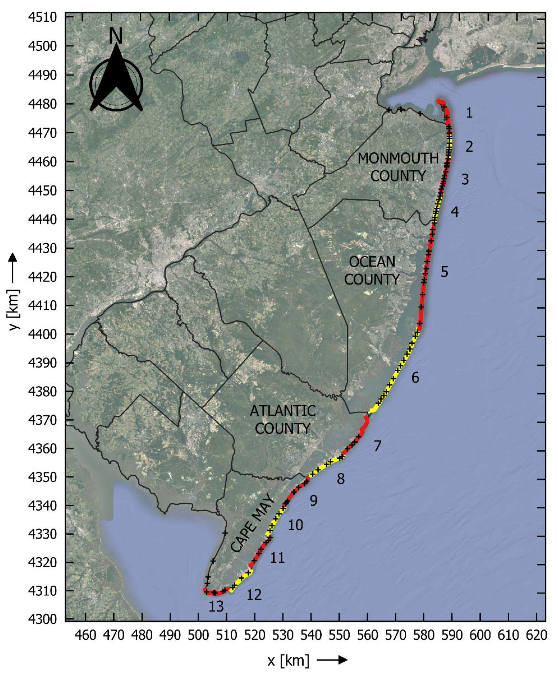
This study focuses on New Jersey’s Atlantic coastline, which has some of the most populated and developed barrier islands in the country [29]. The barrier islands, in addition to the coastal bluffs of central Monmouth County, and the barrier-spit system of Sandy Hook are fronted by sandy beaches (d50 = 0.2 to 0.6 mm). The largest and most persistent dunes tend to be located in the central part of the state in Ocean County (Figure 2).
The region typically experiences three to four storms per year, comprised of both tropical and extratropical events [26]. Events such as Hurricane Sandy (2012), the Veteran’s Day Storm (November 2009), and the December 1992 nor’easter represent some of the most extreme events in recent history. Observed impacts during these storms were widespread, with the degree varying by town, arguably based on both spatially varying erosion potential and vulnerability.
The erosion potential of these events and others was captured by Lemke and Miller [26] using the Storm Erosion Index. Specifically, they characterized the intensity of approximately 130 storms occurring between 1980 and 2013 at thirteen shoreline segments within the state (Figure 2) using information extracted from available wave and water level hindcasts. Storm intensities were reported in terms of SEI, representative of the cumulative erosion potential of the storm, and PEI, representative of the maximum erosive power of the storm.
Many of the 130 events identified and classified by Lemke and Miller [26] could be described as minor, with SEI values an order of magnitude lower than the statewide maximum. In between those minor events, and the upper three events listed above, were those of more moderate and perhaps more typical erosion potential. In contrast to events such as Hurricane Sandy, which has had countless publications dedicated to documenting its impacts, e.g., [1,22,30], those of moderate intensity tend to be less well documented. However, these events have also caused dune erosion, particularly in areas where dunes were more vulnerable. This study aims to capture these events as well, building a model capable of predicting dune erosion due to storms of varying intensities (i.e., moderate and high erosion potentials).
From the climatology, eighteen events were identified as those most likely to have produced dune erosion based on storm intensity alone. These events were ranked in the top twenty storms by either SEI or PEI. Table 1 provides a list of these storms as well as their statewide average SEI and PEI values. In general, these storms have return periods of greater than one year. The storms capture a range of storm types including high-intensity, short-duration events such as Hurricane Irene (August 2011) and lower-intensity, long-duration events such as the 12 October 2005 storm.

3. Methodology

3.1. Data Compilation and Preliminary Analysis

To achieve the study objectives listed above, a robust data set of storm characteristics, pre-storm morphological conditions, and observed dune erosion was built leveraging existing long-term records for the region. Spatially varying storm characteristics were extracted for the storm subset (i.e., those listed in Table 1) from the climatology produced by Lemke and Miller [26]. The parameters included SEI, PEI, maximum water level (MaxWL), maximum breaking wave height (MaxHb), storm duration (td), and cumulative wave energy (cumE).
Pre-storm morphological data and observed dune erosion were obtained for each storm from the New Jersey Beach Profile Network (NJBPN). The NJBPN, maintained by The Stockton University Coastal Research Center, included profile data available at 110 locations throughout the state (Figure 2). This information was collected annually from 1986 to 1994 and then biannually (spring/fall) thereafter using a total station [32] with an accuracy on the order of centimeters [33]. Unless a storm occurred, dune morphology in these locations was unlikely to change significantly by natural processes in the time between these surveys. Therefore, these data were determined to be sufficient for identifying storm-induced dune erosion.
At each NJBPN location, pre- and post-storm profiles were identified for each storm. Only profiles which included a dune in the pre-storm profile were utilized in the analysis. On average, pre-storm surveys occurred 3 months before storm occurrence, while post-storm surveys occurred 2 months after storm occurrence. It was assumed that observed dune impacts were the result of the identified storm and not the result of multiple smaller storms. Any profiles for which a set of pre- and post-storm surveys bound more than a single significant storm event were not considered in the analysis. Any profiles where a coastal protection project (i.e., beach nourishment) occurred between pre- and post-storm surveys were also excluded.
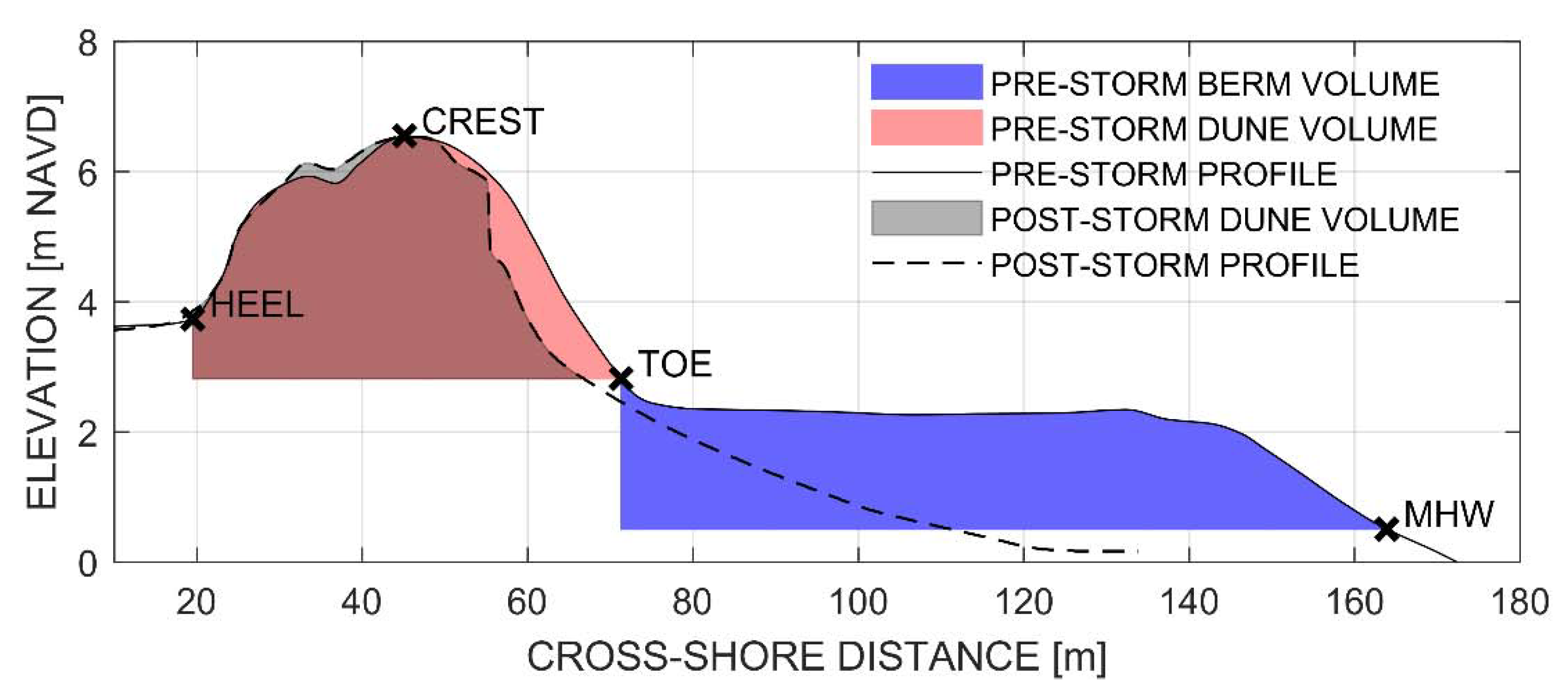
From each of the pre-storm profiles, a series of morphological parameters characterizing the vulnerability of the profile to storm-induced changes were extracted. A schematic of these parameters is presented in Figure 3 while definitions are provided in Table 2. Automated methods for extracting the dune crest and toe positions were developed following that of Brodie and Spore [34]. Specifically, the dune crest was identified as the maximum seaward observed elevation within the primary dune and dune toe was identified by the seaward maximum in curvature. The dune heel was defined as the landward most position where the slope was greater than 1:20. When possible, a comparison between these extracted features and those identified from aerial imagery taken around the same time was performed as a validation of the extraction methods.
Storm-induced dune impacts were quantified by comparing the pre- and post-storm profiles. While other impacts including the change in position (i.e., recession and/or reduction) of the dune crest and toe were initially considered, this study focused on volume loss within the pre-storm dune footprint (Figure 3). Volume losses were reported as a percentage of the pre-storm dune volume:
d l o s s ( % ) = A p r e A p o s t A p r e × 100
This parameter was a reliable indicator of overall dune performance. In comparison, relying on dune toe recession or crest reduction alone led to misinterpretations regarding the severity of dune impacts. For example, in several cases, material removed from the foredune was deposited at the dune toe and the toe appeared to move seaward despite net losses in volume and crest height. Additionally, crest heights appeared to remain constant in wide flat dunes despite extensive losses to the foredune.
Dune impacts were classified into one of three classes based on percent loss (Table 3). Damages were classified as Major when volume losses were greater than 40%, Moderate when volume losses were between 5% and 40%, and Minor when volume losses were less than 5%. During Hurricane Sandy, dunes with greater than 40% loss typically exhibited signs of overtopping (i.e., loss of crest elevation; sand deposited landward of the dune). In situations where the dune is overtopped, landward structures may be subject to damage.
Preliminary analyses were performed on the compiled storm and morphological data prior to use in model development. The range of data was evaluated to confirm that the data set provided sufficient coverage to train and test a data-driven model. Correlations between all parameters, including those describing impacts to the dune, were evaluated through the calculation of a Spearman’s rank correlation coefficient. This analysis was performed to highlight relationships between the variables as well as to reduce the number variables used as input to the model. The results and implications of this analysis are discussed in a later section.

3.2. Classification and Regression Tree (CART) Analysis

This study used classification trees to investigate the relationship between the predictor variables (storm and beach characteristics) and the output variable (dune damage class). In general, classification trees, like other data-driven models, rely on identifying patterns within a training data set and using those patterns to predict future outputs. Specifically, classification trees employ a series of binary splits based on the predictor variables to sort data into homogeneous groups based on the output class. Although considered relatively simple, they can reveal underlying interactions between data and identify the most important predictor variables from a large list of those considered. Other advantages to classifications trees include their insensitivity to the underlying distribution of the data; ability to handle missing data; use of numerical and categorical predictor data; and insensitivity to outliers.
For the present study, the compiled data set was split into two subsets, one used to train the model and the other used to independently test the model. The samples for each subset were randomly chosen without replacement with 70% belonging to the training set and 30% belonging to the testing set. A classification tree was generated using the training data to predict the expected dune damage class based on a reduced set of the predictor variables. The classification tree was grown to its full depth and subsequently pruned following the procedures outlined in Breiman et al. [35] and summarized in De’ath and Fabricius [36] and Olden et al. [37]. Pruning was performed to improve the model’s performance in predicting the outputs of new samples by generalizing trends and reducing overfitting.
Because of the model’s tendency to produce false negatives (i.e., dune damage predicted as class lower than observed), a custom misclassification cost matrix was introduced to penalize the errors associated with false negatives as higher than those associated with false positives. False negatives were considered riskier as they could, in a forecasting application, lead to an underestimation of expected impacts and underprepared communities. Misclassification of an observation into one class lower (i.e., observed Major damage misclassified as Moderate or observed Moderate damage misclassified as Minor) was “c” times worse than a false positive. Misclassification of an observation into two classes lower (i.e., observed Major damage misclassified as Minor) was c2 worse than a false positive. A sensitivity test was performed to determine the optimal cost coefficient (c).
This first model was found to be unstable, meaning that small changes in the training sample led to differently grown trees and ultimately performance. Instability is recognized as a common drawback to tree models which manifests from a classification tree’s inherent tendency to select splits which optimize the model for a particular training sample, even when pruned [38,39]. For this reason, ensembles are often utilized with the aim of reducing the final prediction’s variance by averaging the result over many trees. While several methods are available (e.g., boosting; random forests), the present study found that bootstrap aggregation, or “bagging”, resulted in the optimal ensemble. This procedure involved taking a specified number of bootstrap samples of size “N” from the training set of size “N” and growing a tree from each sample [40,41]. Performance of the model was evaluated using the resubstitution error of the training set and error of the testing set. Performance was sensitive to the number of trees included in the ensemble and the depth of those trees. Similar to the single classification tree, a custom misclassification cost matrix was introduced to weight the error associated with particular observations as higher than others. Sensitivity tests were performed to determine the optimal configuration (i.e., misclassification cost coefficient (c); number of trees; depth of trees).

4. Results

4.1. Preliminary Analysis

The final data set had 865 sets of observations compiled across eighteen storms between 1991 and 2012. On average, there were 48 sets of observations associated with each storm. Storms with less than this (as few as 20) tended to occur before 2000, while those after 2000 tended to have more (up to 70 profiles each). This was a result of: (1) reduced frequency of surveys prior to 1994; (2) reduced number of profiles surveyed in the state prior to 2000; and (3) the reduced number of profiles with dunes prior to 2000.
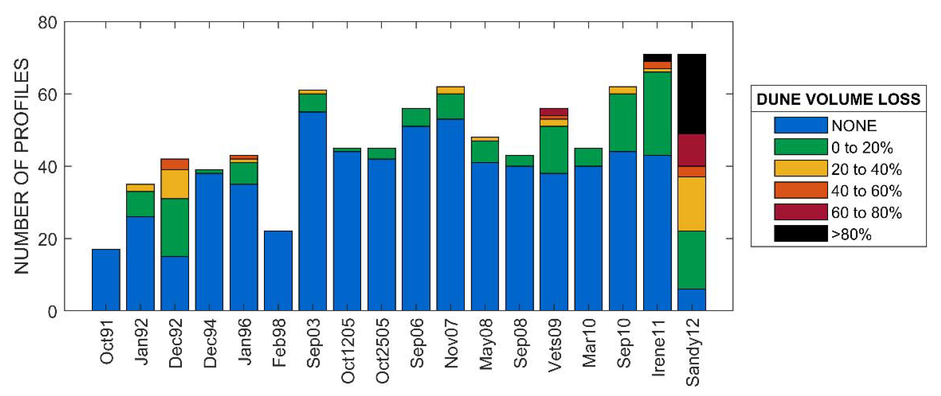
The eighteen storms captured a full range of impacts, with losses extending from 0% to 100%. The most impactful storm (Hurricane Sandy) resulted in losses of greater than 40% at nearly half of the profiles (Figure 4). There was a clear skew in the data with 85% of the observed dune impacts being classified as Minor damages, 10% as Moderate, and 5% as Major. Typically, only the most extreme storms resulted in dune damage and even then, only at a portion of the profiles with the clear outlier being Hurricane Sandy.
It should be noted that Figure 4 only reflects profiles where the impacts could be attributed to a single storm. Profiles where there were impacts but it could not be reasonably ascertained which storm caused the erosion based on the pre- and post-storm survey dates were not included. Therefore, it should not be assumed that storms such as the October 1991 or the September 2008 storms resulted in no impacts to the dune in the state. Their impacts simply could not be discerned from those caused by similarly intense storms (e.g., January 1992; May 2008) occurring between pre- and post-storm surveys.
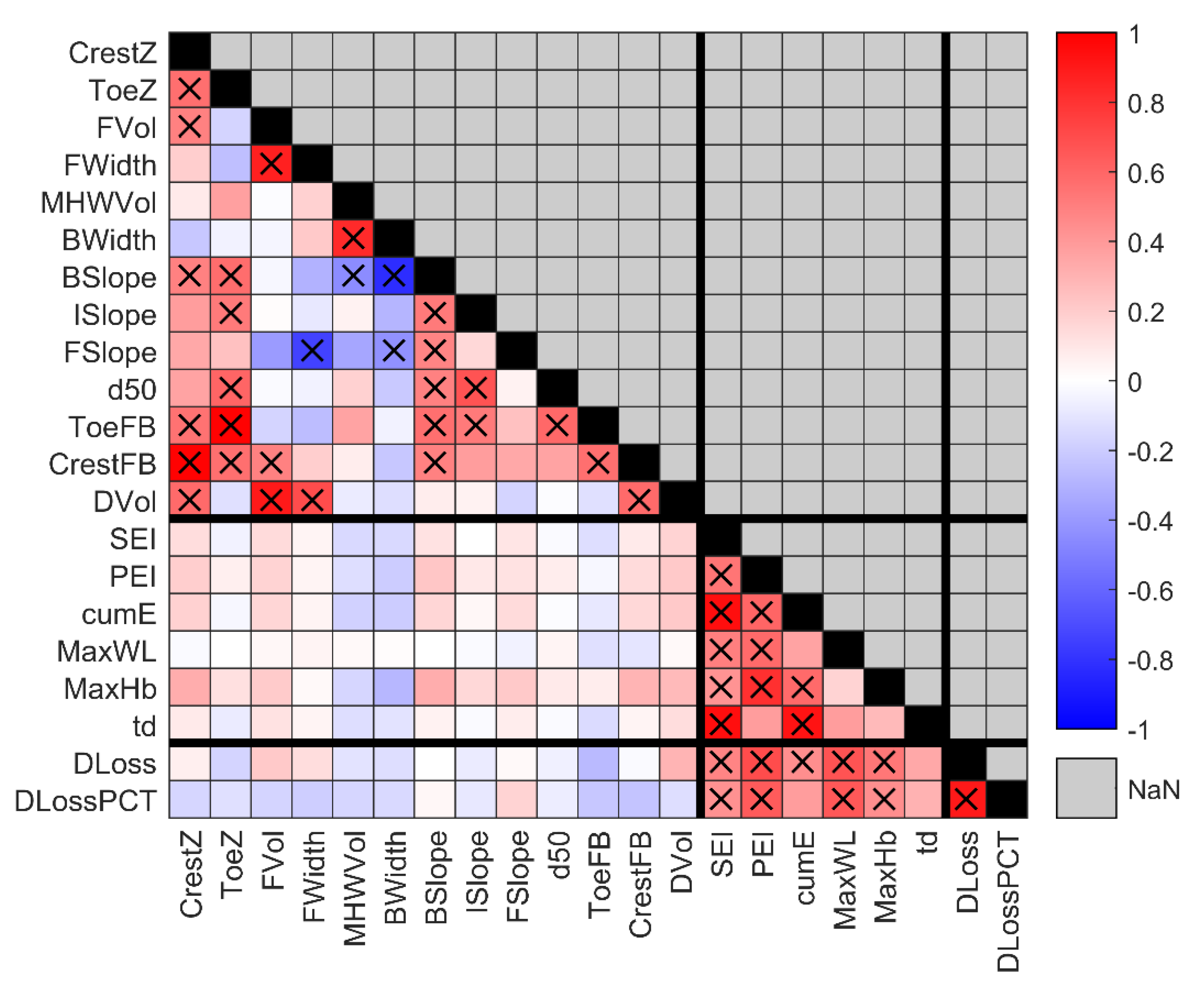
The correlation analysis between all parameters was utilized to identify predictor variables which were highly correlated with one another as well as to identify those correlated with the response variables. This analysis was adapted from that presented by Beuzen et al. [19]. Figure 5 shows the Spearman rank correlations between all parameters. Important correlations, namely those which had correlations (ρ) greater than 0.4 and were statistically significant to the 95% level (p < 0.05), are highlighted by black “X” markers.
The storm intensity parameters were found to have strong and statistically significant correlations with the response variables. The strongest correlations were that of SEI, PEI, MaxWL, and MaxHb with values between 0.5 and 0.7. Generally, as storm intensity increased, the observed dune percent loss also increased. However, for all the comparisons there was spread in the data, indicating that a combination of parameters likely controlled dune erosion. This interaction was investigated using the classification trees discussed in the following section.
The correlation results were also utilized to reduce the number of variables used as input and limit redundancy in the model. Many of the predictor variables showed strong and significant correlations with one another. As an example, the volume of sand contained within the berm (MHWVol) was, not surprisingly, highly correlated with both berm width (bwidth) (ρ = 0.83) and berm slope (bslope) (ρ = −0.82). Therefore, only berm volume was considered as input to the classification tree and berm width and slope were initially excluded. Similarly, maximum water level, maximum breaking wave height, and storm duration were not included as they were highly correlated with SEI and PEI. These strong and significant correlations were expected as SEI and PEI combine wave and water level information in a physically meaningful way to describe storm intensity (see Equation (1)). Individual tests were performed to examine whether including variables initially excluded improved model performance. Results did not show substantial improvement for the classification tree models. The final list of parameters utilized in as input in the model were:
  • Crest elevation (CrestZ)
  • Toe elevation (ToeZ)
  • Berm volume (MHWVol)
  • Dune volume (DVol)
  • Sediment grain size (d50)
  • The Storm Erosion Index (SEI)
  • Peak Erosion Intensity (PEI)

4.2. Prediction of Damage Classes

This section describes two model configurations that were developed to predict the expected damage classes using the predictor variables selected in the previous section. The first, a single classification tree, revealed underlying patterns in the data set, which were then used to examine the role of each predictor variable in controlling dune erosion. Instability in this model, however, ultimately led to the pursuit of a more complex model comprised of many individual classification trees. Details related to this are provided below. This second model had improved performance and thus provided a path forward regarding future applications.
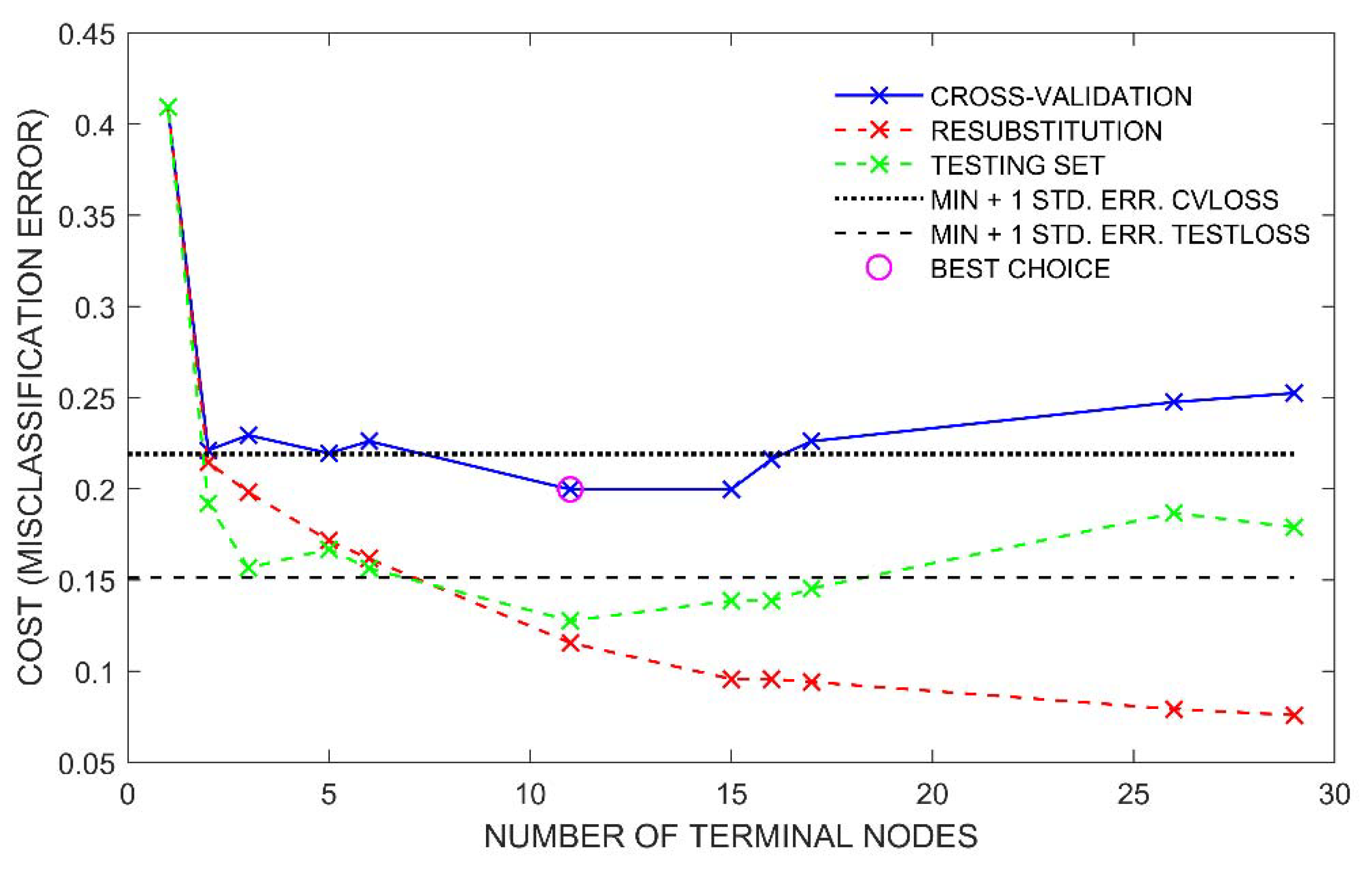
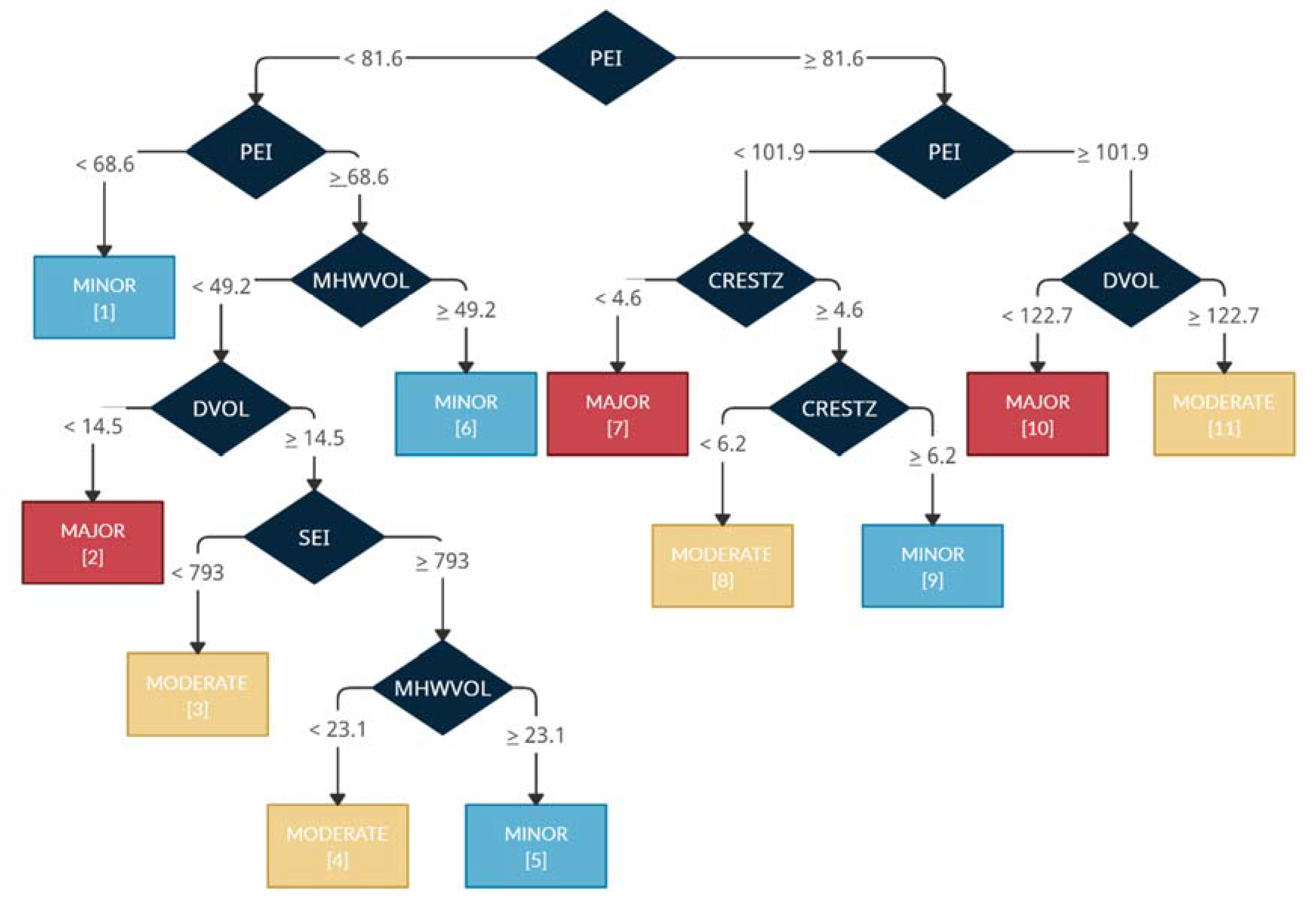
The first model, a single classification tree with a custom misclassification cost matrix (c = 2), was grown to its full depth (29 terminal nodes) and then pruned to 11 terminal nodes. The terminal nodes’ classes represented the most common damage class associated with the observations sorted into each node. The final depth was selected because it minimized the misclassification rate of the testing set and the 10-fold cross-validation error (Figure 6). The pruned tree is presented in Figure 7 with node statistics listed in Table 4.
The tree indicated that both storm intensity and morphological features were important in determining storm-induced dune impacts. The first two splits were based on PEI, indicating that it explained the majority of the variation within the data set. Observations with PEI values less than 69 were typically associated with Minor damage and those with PEI values greater than 102 were typically associated with either Moderate or Major damage, dependent upon dune volume. In between 69 and 102, a full range of classes were expected, dependent upon the pre-storm morphology. The overall accuracy of the model based on the training and testing set combined was 92%, with 91% of the observed Major damages, 55% of the observed Moderate damages, and 96% of the observed Minor damages classified properly (Figure 8, left).
The presented model was determined to be unstable, meaning that using an alternative random sample of the training set changed both the configuration and performance of the pruned tree. As discussed in the section above, this is a common occurrence with classification trees due to their tendency to optimize the splitting criteria (i.e., variable and value) for a particular training set. For this study, the tendency was likely exacerbated due to the skewness of the data towards Minor damages. Relative to the whole sample there were a small number of observed Moderate and Major damages. The splitting criteria for these damage classes in the model were then sensitive to which samples were selected from the training set. Despite this, one feature which was consistent across the alternative trees was the use of PEI for the initial split (splitting value typically between 70 and 100). This was attributed to the high importance of this variable. However, other properties of the tree including the variables and values used for subsequent splits and the optimal tree size varied. This exercise illustrated the sensitivity of model development to the set of observations included in the training data. Although alternative trees exhibited some similar characteristics, their differences inherently affected the overall accuracies and raised questions of which tree was truly optimal. Therefore, utilizing an ensemble of trees was explored to reduce the variation in model output. Among the methods commonly used to build an ensemble, bootstrap aggregation was found to have the best performance. For brevity, only the results using this method are presented.
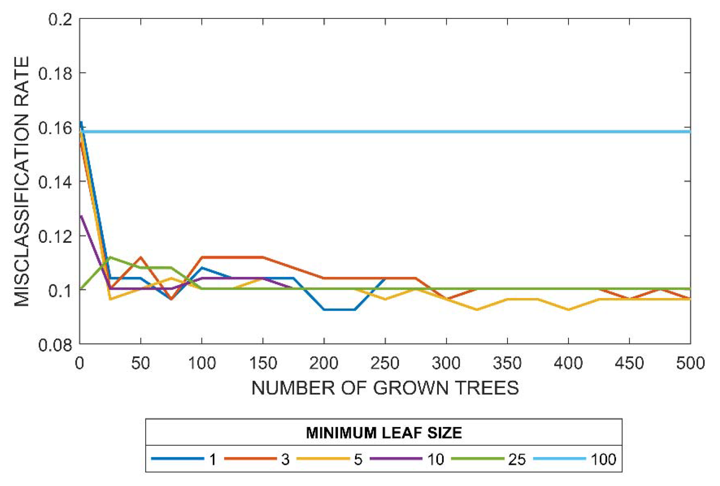
A second model, a classification tree ensemble, was grown considering the selected predictor variables. The model included 260 trees, each grown so that the terminal nodes were homogenous (minimum leaf size of 1). This configuration was chosen as it resulted in a smaller misclassification rate of the testing set among the configurations tested. The tested configurations included ensembles composed of up to 500 trees with minimum leaf sizes up to 100 observations. For each minimum leaf size, errors generally stabilized around 250 to 300 trees, if not earlier, indicating that the model would not benefit from the addition of more trees (Figure 9).
Of those tested, the poorest performing configuration was that with a minimum leaf size of 100 observations. This model overgeneralized and did not allow for individual sets of observations to be distinguished, no matter how many trees were included. The model was found incapable of predicting either Moderate or Major damages, thus leading to a permanent misclassification rate of the testing set of 16% (Figure 9). With 100 observations in each terminal node, the limited number of Moderate and Major damage observations in the training set were always outnumbered by observations of Minor damage, leading to all terminal nodes being assigned to the Minor damage class.
Across the remaining configurations (i.e., minimum leaf size of 25 or smaller), the misclassification rate of the testing set was similar (approximately 10%). It should be noted, however, that this rate reflected the misclassification across all three classes. As discussed in the previous section, due to the potential implications it could have on pre-storm preparations, correctly classifying Moderate and Major damages was considered more important than correctly classifying Minor damages. With further inspection, it was found that smaller minimum leaf sizes tended to reduce the misclassification rate of Moderate and Major damages. In other words, these configurations created models with higher accuracy at the Moderate and Major damage class. For example, an ensemble of 260 trees with a minimum leaf size of 25 correctly classified 45% of Moderate and Major damages. An ensemble with the same number of trees and a minimum leaf size of 1 correctly classified 72%. Therefore, the selected configuration used a minimum leaf size of 1.
Accuracy at the Moderate and Major damage class was further increased by introducing a custom misclassification cost matrix. Improvements in the accuracy at these classes resulted in a corresponding decrease in the accuracy at the Minor damage class. Generally, this was considered an acceptable tradeoff. After sensitivity testing, a matrix with a cost coefficient of 7 was selected. Accuracy at the Moderate and Major classes increased to 88%, while still maintaining an accuracy of 92% at the Minor damage class (Figure 8, right). Increasing the cost coefficient further showed little benefit to the model. For example, using a coefficient of 15 only increased accuracy at the Moderate and Major damage classes to 92% while decreasing that at the Minor damage class to 77%.
The selected classification tree ensemble configuration was preferable to the single tree for both its stability and accuracy. While the overall accuracies of the two models were similar, the ensemble correctly classified more of the Moderate and Major damages. This improvement was most apparent at the Moderate damage class with accuracy increasing from 55% to 84% (Figure 8). It is believed that this improvement was due to the ability of the ensemble to identify and use patterns that were either not identified or were pruned in the single tree model. As discussed above, the single tree was strategically pruned to 11 terminal nodes to avoid overfitting and improve the model’s prediction capability. This tree, therefore, included the most prevalent patterns and removed those which were less important to error reduction. As shown in Table 4 and Figure 8 (left), this led to the misclassification of observed Moderate and Major damages.
The classification tree ensemble, on the other hand, consisted of individual trees where the terminal nodes were homogenous. These trees identified all patterns in the bootstrap samples used to build the trees, separating observations so that no misclassifications occurred within the sample. Individually, these trees would be poor predictors of damage. However, by averaging results over 260 trees, it was anticipated that the correct output class was more likely to be obtained. This prediction took into consideration all underlying patterns, which may have aided in the proper classification of Moderate and Major damage observations originally misclassified by the single tree.
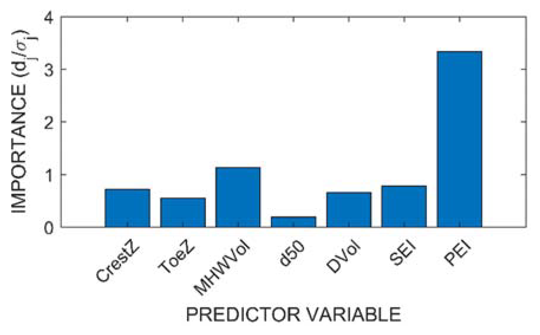
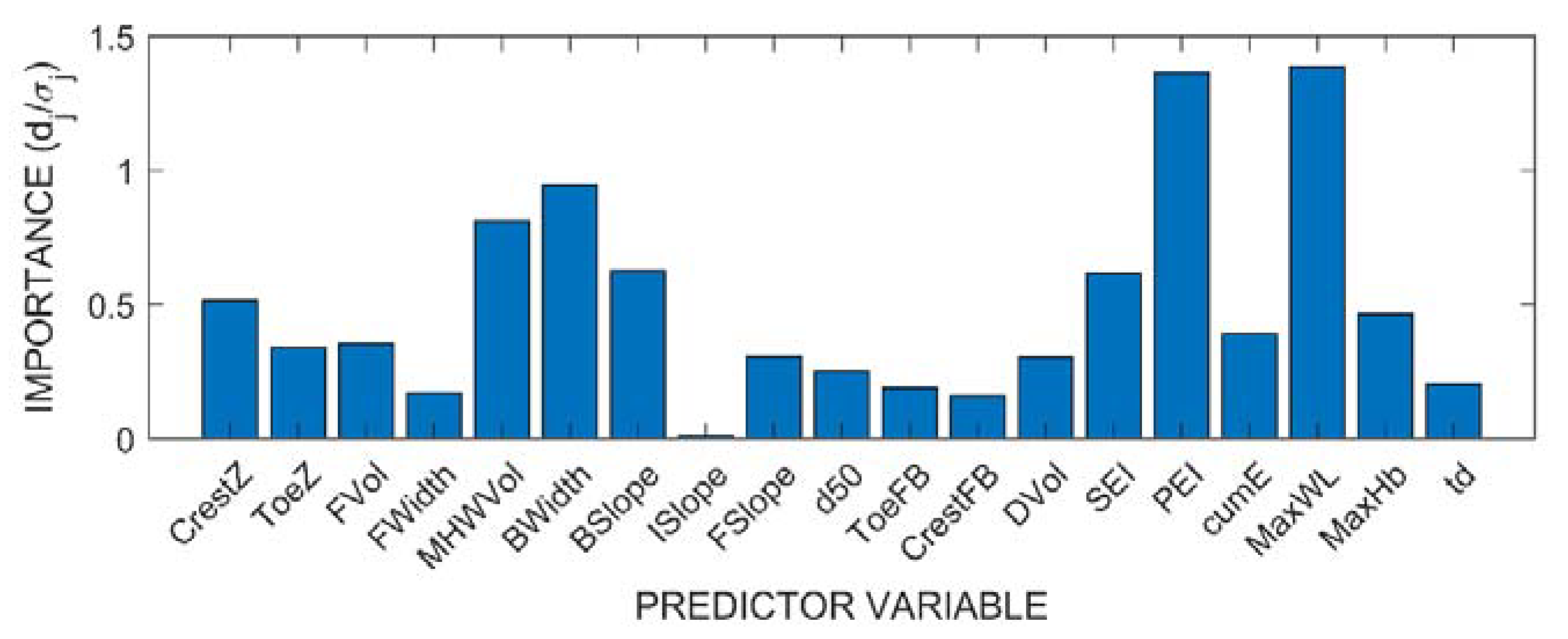
Figure 10 (top) presents predictor importance estimates for the seven predictor variables based on the ensemble model. Predictor importance estimates reflect the difference in resubstitution error if the value of the predictor variable used to split the node were randomly selected versus strategically selected to maximize homogeneity. The higher this value, the more important the variable was considered. In the case of an ensemble, this change in error was averaged across all trees and divided by the standard deviation to reflect the spread. Of the seven variables included, PEI had the highest predictor importance estimate, approximately three times higher than that of the next variable. The value was greater than one, meaning that the average error was greater than the standard deviation. This indicated that across all trees this variable was critical in explaining the variation in dune damages.

5. Discussion

5.1. Predictors of Dune Impacts

The correlation analysis and classification trees presented in the previous section highlighted the most important parameters in controlling dune impacts and the interaction of those parameters. The predictor variables with the strongest correlations to the response variables were the storm characteristics (Figure 5). This suggests that storm intensity was most important in controlling dune erosion. While increased storm intensities (e.g., PEI) increased the likelihood of more significant impacts, observed spread indicated that secondary factors (i.e., beach and dune morphology) play a role as well.
With regard to storm intensity, both model configurations supported PEI as the most important predictor. The predictor importance estimate for PEI, based on an ensemble of 260 trees, was more than three times larger than the next highest (Figure 10, top). The individual classification tree indicated that it was most important to split the observations by storm intensity (i.e., PEI) before considering site-specific morphological parameters (Figure 7). While not presented, similar patterns were found in the individual trees of the ensemble model as well.
PEI was used by the individual classification tree to initially split the data into four groups. From the training set, 33 observations were sorted into the highest storm intensity group (PEI > 102) where either Moderate or Major damages were typically observed. This implied that under most beach conditions in New Jersey, the wave and water level conditions which combined to create a PEI greater than 102 were large enough to erode the dune. The magnitude of these losses (i.e., Moderate or Major damages) were dependent upon the beach conditions with dunes of larger volume experiencing smaller percent losses. From the training set, 407 observations were sorted into the smallest storm intensity group (PEI < 69), where Minor damages were typically observed. This result implied that under most beach conditions in New Jersey, the wave and water level conditions, which combined to create a PEI of less than 69 were not large enough to erode the dune.
The importance of PEI (versus SEI) suggests that dune erosion is controlled by what is happening at a storm’s peak. PEI reflects the maximum instantaneous erosion intensity during the storm and is influenced by the breaking wave height, water level, and the timing of the two maxima in relation to one another. At this peak, elevated water levels and wave heights combine in such a way to allow hydrodynamic forces to reach the dune either via wave run-up or direct impact of waves. A separate analysis, where the importance estimates were calculated for all nineteen of the originally considered predictor variables, suggested the importance of PEI was driven by maximum water level (Figure 10, bottom). The predictor importance estimates of PEI and MaxWL were of similar magnitude (1.25–1.5) and were approximately 50% larger than the next highest set (MWHVol and BWidth at 1).
Parameters of secondary importance, reflecting local beach morphology, explained how much erosion a storm of a particular intensity could achieve. Understanding morphological conditions was critical in estimating damages at Moderate storm intensities (PEI 69–102) where there was no consistent morphological response. Specific parameters which were identified as important considering both the individual tree and the ensemble included dune volume, dune crest and toe elevations, and berm volume.
In general, for similar storm intensities, larger dunes both in terms of volume and crest elevation were associated with smaller percent losses. For example, all Major damages in the training set associated with storms of PEI > 102 occurred when dune volumes were less than 123 m3/m (Figure 7, Table 4). Dune volume controls how much erosion is required to achieve either Moderate or Major damages. A loss of 40 m3/m for a smaller dune may be catastrophic with the dune being entirely removed (Major damage) while at a location with a much larger pre-storm dune (e.g., >123 m3/m) the same volumetric loss may be categorized as Moderate. The importance of crest elevation is in part related to dune volume as the two parameters are correlated (Figure 5). Dunes with higher crest elevations tended to have greater total volume than dunes with lower crest elevations. For storms with PEI between 82 and 102, all Moderate and Major damages in the training set occurred when the crest elevation was less than 6.2 m NAVD.
The importance of crest elevation, in addition to toe elevation, suggests that the position of the dune relative to the water level is also important in controlling erosion. Together, the two parameters control how much of the dune face is exposed to hydrodynamic events. These elevations have been previous used by Sallenger [21] to classify expected dune impacts into one of four regimes by comparing the elevations to that of the 2% exceedance wave run-up. Specifically, the toe elevation is important in explaining when hydrodynamic forces begin to directly impact the dune while the crest elevation is important in explaining when the dune is overtopped. While not shown in the presented classification tree, toe elevation was utilized in the fully grown classification tree and the individual trees of the ensemble to split the data. Here, dunes with lower toe elevations were more likely to have Moderate or Major damages. In the training set, the single observed case of Major damage for PEI < 69 occurred at a location where both the toe elevation (1.4 m NAVD) and berm volume (8 m3/m) were lower than typical.
Finally, the beach berm serves as a buffer for the dune. For observations of similar storm intensities, dunes fronted by larger berms (i.e., higher MHWVol) were typically associated with lower percent losses. For example, for a PEI between 69 and 82, all Major and Moderate damages occurred when the berm volume was less than 49 m3/m (Figure 7, Table 4). For the ensemble model, berm volume had the second highest predictor importance estimate. Physically, the berm provides protection to the dune through two mechanisms. For storms of lower intensity where the wave run-up does not reach the toe of the dune, the berm volume represents the material available to erode before the dune is directly impacted. However, at higher water levels where the berm is submerged, the berm width (correlated with berm volume, Figure 5) represents the distance over which wave energy is allowed to dissipate before reaching the dune.
While the model explained a majority of the variation in the training and testing sets using seven predictor variables, there remained some misclassified observations. Some of this variation may be explained by inherent inaccuracies in the compiled data set associated with timing of the surveys. Pre-storm surveys typically occurred three months before storm occurrence. While dune volumes are not expected to change significantly over this time by natural mechanisms (unless in the event of a storm), berm volumes and widths are expected to fluctuate. This change can be seasonal, the result of changes in wave climate. Seasonal shoreline changes on the order of tens of meters from the mean position have been reported [42,43,44]. Therefore, the true berm width and berm volume may be different than that estimated by the available survey. This may introduce errors as berm volume was identified as the second most important control on dune erosion.
The current work focused on parameters believed to be the primary controls of dune erosion and investigated them leveraging existing data sets. A particular emphasis was placed on PEI and SEI, parameters used to describe storm intensity, for which a quantitative relationship to observed dune impacts had yet been established. It is recognized that there are parameters outside of the current work that may explain a portion of the remaining variation in the model including proximity to coastal structures [45,46,47], presence of offshore bars [48], and the cover and type of dune vegetation [49,50,51].
Of all the parameters considered, this study highlighted the importance of a storm’s peak conditions, described through PEI, in controlling dune erosion. Recognizing this, additional parameters describing the length and timing of that peak may become importance to consider. For example, if the peak intensity occurred at the beginning of a storm, the berm width and volume would be close to the pre-storm condition and would provide the greatest level of protection. However, if the peak occurred towards the end, the berm would likely have eroded and would provide a lower level of protection, yielding potentially greater impact to the dune. Other studies have noted improved estimates of erosion using empirical models when considering the time evolution of the profile during the storm [52]. This is expected to be most important for storms of long duration which have the ability to yield significant berm erosion before peaking. It is likely that this is linked to SEI which reflects a storm’s time-varying erosion intensity and is sensitive to a storm’s total duration. Further, storms which maintained peak conditions for a longer duration would likely cause greater dune erosion than more short-lived events as the dune would be exposed to hydrodynamic forces for a greater length of time. Therefore, it may be useful to define a second storm duration capturing this peak. It is suggested that future studies investigate ways to quantify both the timing and duration of a storm’s peak using the Storm Erosion Index and explore the role of these parameters in dune erosion.

5.2. Model Performance

With the goal of creating a model that accurately predicted the expected impact to coastal dunes, the performances of two model configurations were compared to determine the optimal one for use in future applications. The two models underwent rigorous optimization and testing to assess sensitivity to training set selection, misclassification cost coefficient (c), tree size, and predictor parameter selection. The single classification tree was pursued first as its simplicity was deemed advantageous. However, because of the instability associated with the configuration, it was superseded by the ensemble over which individual outputs were averaged to determine a final output. Accuracies were improved, particularly at the Moderate damage class. Overall, the ensemble model was most accurate at the two extremes (92% accuracy for Minor damages; 98% for Major damages) and less so for that in between (84% for Moderate damages).
It is important to note that data-driven models, such as those discussed in this study, have inherent uncertainty in the predictions they provide as they do not account for all physical processes that govern a particular outcome such as dune erosion. In the case of the models presented here, predictions were based on seven variables which schematized a given storm and beach profile. While more parameters may be added in the hope of capturing additional aspects of the physical processes, the model is unlikely to capture every consideration included in a process-based model. Despite this limitation, the model developed here was capable of providing reasonable predictions of storm-induced dune erosion and was shown to be a viable alternative, particularly in applications where computational efficiency is required.
When the model is applied, some measures may be taken to limit how much uncertainty there is in the results. For example, model application should be limited to the range of data over which it was trained and tested. Table 5 presents the ranges for the seven predictor variables. It is expected that estimates based on sets of observations far outside of these ranges will have increased errors and will be associated with greater uncertainty. For application of the model on beaches of similar characteristics over typical events, the data were considered adequate as profiles and storms throughout the state over thirty years were captured. The profiles captured conditions ranging from those recently nourished to those due for renourishment. If applying the model in a region where the conditions were very different than that presented, the model would likely need to be retrained.
The model was trained using a range of storm conditions describing events with return periods of at least one year to that of 50 years. Storms less intense than those over which the model was trained are expected to have little impact. An exception to this would be non-typical beach conditions, where the dune and/or beach were very small. Only a single observation such as this appears to exist in the training data set. Storms more intense than those over which the model was trained should be treated with a higher level of uncertainty. For this study, the largest event was Hurricane Sandy, which had a maximum PEI of 163. The developed model determined that for PEI values greater than 102, at least some significant impact (Moderate/Major damages) was likely to occur regardless of the beach conditions. These portions of the trees were trained with a limited number of observations (33 observations). Splits by PEI and other morphological factors may change if considering more intense storms. It is suggested that the model be retrained with a data set supplemented by simulated morphological responses to extreme events to expand the range over which the model is valid.

6. Conclusions

Previous works [14,27] have established qualitative relationships between storm intensity, described by the Storm Erosion Index, and storm-induced impacts on beaches and coastal communities. Prior to this work, however, a direct quantitative relationship did not exist. Previous studies were limited in both the quality and quantity of observed data from which comparisons could be made. This study documented the compilation of a robust data set from which the role of storm intensity, described by SEI and PEI, and beach morphology in controlling dune impacts was investigated. Tools including a simple correlation analysis and more involved data-driven models were utilized to achieve the study objectives. Specifically, the role and relative importance of different erosion controls were evaluated while also creating a computational efficient model, which enables predicting dune erosion on a local scale.
Preliminary analysis revealed that dune impacts, described by percent losses, were highly correlated with storm characteristics. However, spread in the data suggested it was likely a combination of parameters that controlled dune impacts. Through the development of two data-driven models, PEI, berm volume, and dune volume were determined to be the most important factors among those tested. Although the single classification tree was ultimately superseded by the ensemble based on performance, the model was valuable in that it provided a visual display on how the different predictors interacted to ultimately predict a damage class. On its own, PEI was successful in distinguishing between storms most likely to result in no impacts (PEI < 69) and those likely to result in some (PEI > 102) regardless of the beach conditions. For intensities in between, where no consistent behavior was observed, beach conditions must be considered in combination with PEI to estimate impacts.
The parameters that were identified as most important in predicting storm-induced impacts were consistent with existing literature. Historically, wave run-up, which is dependent upon water level and wave height, has been linked to dune erosion [17,21]. PEI, which is dependent on similar variables, was identified as the most important parameter in the developed models. PEI reflects the maximum instantaneous erosion intensity during the storm. SEI, reflecting the cumulative erosion potential, had a much lower predictor importance factor than PEI. This suggests that the peak conditions (highest water level; largest wave heights) that typically occur over several hours were most critical in predicting dune impacts. This is consistent with that indicated by previous studies where dune erosion was controlled by the conditions under which the dune was directly impacted by waves and the time over which that direct impact occurred, e.g., [52,53]. The importance of berm volume (and width) and dune volume, the second and third most important factors based on this analysis, has been noted in literature as well, e.g., [17,23].
The results presented here demonstrate the usefulness of the Storm Erosion Index (specifically PEI) for evaluating storm intensity on the basis of readily available parameters. While it can help indicate potential impacts to the primary dune, for the better predictions it must be combined with less readily available, and potentially more spatially and temporally variable beach morphology information. The classification tree ensemble developed in pursuit of exploring the relationship between the parameters enables a number of applications where computational efficiency is advantageous such as regional vulnerability assessments, sensitivity testing, and forecasting. These applications are the focus of future work.

Author Contributions

Conceptualization, L.L. and J.K.M.; methodology, L.L. and J.K.M.; formal analysis, L.L.; data curation, L.L.; writing—original draft preparation, L.L.; writing—review and editing, J.K.M.; visualization, L.L.; supervision, J.K.M.; project administration, J.K.M. All authors have read and agreed to the published version of the manuscript.

Funding

This research was funded by the New Jersey Department of Environmental Protection (NJDEP) through the New Jersey Coastal Protection Technical Assistance Service (N.J.S.A. 18A:64L-1).

Institutional Review Board Statement

Not applicable.

Informed Consent Statement

Not applicable.

Data Availability Statement

Publically available datasets were analyzed in this study. Details regarding these sources can be found at The Stockton University Coastal Research Center (https://www.stockton.edu/coastal-research-center/njbpn/index.html, 1 December 2021) and in Lemke and Miller [26].

Acknowledgments

The authors wish to thank the Stockton University Coastal Research Center for providing the survey profile data. The authors would also like to thank Reza Marsooli (Stevens Institute of Technology), Upendra Prasad (Stevens Institute of Technology), and Kristen D. Splinter (UNSW) for their constructive comments regarding this work.

Conflicts of Interest

The authors declare no conflict of interest. The funders had no role in the design of the study; in the collection, analyses, or interpretation of data; in the writing of the manuscript, or in the decision to publish the results.

References

  1. Barone, D.; McKenna, K.; Farrell, S. Hurricane Sandy: Beach-dune performance at New Jersey Beach Profile Network sites. Shore Beach 2014, 82, 13–23. [Google Scholar]
  2. Tomiczek, T.; Kennedy, A.; Zhang, Y.; Owensby, M.; Hope, M.E.; Lin, N.; Flory, A. Hurricane Damage Classification Methodology and Fragility Functions Derived from Hurricane Sandy’s Effects in Coastal New Jersey. J. Waterw. Port Coast. Ocean Eng. 2017, 143, 04017027. [Google Scholar] [CrossRef]
  3. Houser, C.; Wernette, P.; Rentschlar, E.; Jones, H.; Hammond, B.; Trimble, S. Post-storm beach and dune recovery: Implications for barrier island resilience. Geomorphology 2015, 234, 54–63. [Google Scholar] [CrossRef]
  4. Morton, R.A.; Jeffrey, G.P.; James, C.G. Stages and Durations of Post-Storm Beach Recovery, Southeastern Texas Coast, U.S.A. J. Coast. Res. 1994, 10, 884–908. [Google Scholar]
  5. Mathew, S.; Davidson-Arnott, R.G.; Ollerhead, J. Evolution of a beach–dune system following a catastrophic storm overwash event: Greenwich Dunes, Prince Edward Island, 1936–2005. Can. J. Earth Sci. 2010, 47, 273–290. [Google Scholar] [CrossRef]
  6. Schott, T.; Landsea, C.; Hafele, G.; Lorens, J.; Taylor, A.; Thurm, H.; Ward, B.; Willis, M.; Zaleski, W. The Saffir-Simpson Hurricane Wind Scale; NOAA/National Weather Service: Silver Spring, MD, USA, 2012.
  7. Simpson, R.H.; Saffir, H. The hurricane disaster potential scale. Weatherwise 1974, 27, 169. [Google Scholar]
  8. Dolan, R.; Davis, R.E. An intensity scale for Atlantic coast northeast storms. J. Coast. Res. 1992, 8, 840–853. [Google Scholar]
  9. Mendoza, E.T.; Jimenez, J.A.; Mateo, J. A coastal storms intensity scale for the Catalan sea (NW Mediterranean). Nat. Hazards Earth Syst. Sci. 2011, 11, 2453–2462. [Google Scholar] [CrossRef] [Green Version]
  10. Kriebel, D.; Dalrymple, R.; Pratt, A.; Sakovich, V. Shoreline risk index for northeasters. In Proceedings of the 1996 Conference on Natural Disaster Reduction, Washington, DC, USA, 3–5 December 1996; pp. 251–252. [Google Scholar]
  11. Walker, R.A.; Basco, D.R. Application of Coastal Storm Impulse (Cosi) Parameter to Predict Coastal Erosion. Coast. Eng. Proc. 2011, 1, 23. [Google Scholar] [CrossRef] [Green Version]
  12. Kraus, N.C.; Wise, R.A. Simulation of January 4, 1992 storm erosion at Ocean City, Maryland. Shore Beach 1993, 61, 34–41. [Google Scholar]
  13. Zhang, K.Q.; Douglas, B.C.; Leatherman, S.P. Beach erosion potential for severe nor’easters. J. Coast. Res. 2001, 17, 309–321. [Google Scholar]
  14. Miller, J.K.; Livermont, E. A predictive index for wave and storm surge induced erosion. In Proceedings of the 31st International Conference on Coastal Engineering, Hamburg, Germany, 31 August–5 September 2008; pp. 4143–4153. [Google Scholar]
  15. Morgan, K.L.; Krohn, M.D. Post-Hurricane Sandy coastal oblique aerial photographs collected from Cape Lookout, North Carolina, to Montauk, New York, November 4–6, 2012. Data Ser. 2014, 858. [Google Scholar] [CrossRef]
  16. The Stockton University Coastal Research Center. Beach Dune Performance Assessment of New Jersey Beach Profile Network (NJBPN) Sites at Northern Ocean County, New Jersey, after Hurricane Sandy Related to FEMA Disaster DR-NJ-4086; The Stockton University Coastal Research Center: Port Republic, NJ, USA, 2012. [Google Scholar]
  17. Plant, N.G.; Stockdon, H. Probabilistic prediction of barrier-island response to hurricanes. J. Geophys. Res. Space Phys. 2012, 117, 117. [Google Scholar] [CrossRef]
  18. Splinter, K.D.; Kearney, E.T.; Turner, I. Drivers of alongshore variable dune erosion during a storm event: Observations and modelling. Coast. Eng. 2018, 131, 31–41. [Google Scholar] [CrossRef]
  19. Beuzen, T.; Harley, M.D.; Splinter, K.D.; Turner, I.L. Controls of Variability in Berm and Dune Storm Erosion. J. Geophys. Res. Earth Surf. 2019, 124, 2647–2665. [Google Scholar] [CrossRef]
  20. Palmsten, M.L.; Splinter, K.D.; Plant, N.G.; Stockdon, H.F. Probabilistic estimation of dune retreat on the Gold Coast, Australia. Shore Beach 2014, 82, 35–43. [Google Scholar]
  21. Sallenger, A.H. Storm impact scale for barrier islands. J. Coast. Res. 2000, 16, 890–895. [Google Scholar]
  22. Overbeck, J.R.; Long, J.W.; Stockdon, H.F. Testing model parameters for wave-induced dune erosion using observations from Hurricane Sandy. Geophys. Res. Lett. 2017, 44, 937–945. [Google Scholar] [CrossRef]
  23. Judge, E.K.; Overton, M.F.; Fisher, J.S. Vulnerability Indicators for Coastal Dunes. J. Waterw. Port Coast. Ocean Eng. 2003, 129, 270–278. [Google Scholar] [CrossRef]
  24. Deierlein, G.G.; Zsarnóczay, A. State of the Art in Computational Simulation for Natural Hazards Engineering (Version v2); Zenodo: Genève, Switzerland, 2021. [Google Scholar] [CrossRef]
  25. Wehof, J.; Miller, J.K.; Engle, J. Application of the Storm Erosion Index (SEI) to three unique storms. In Proceedings of the 34th International Conference on Coastal Engineering, Seoul, Korea, 15–20 June 2014. [Google Scholar]
  26. Lemke, L.; Miller, J.K. Evaluation of storms through the lens of erosion potential along the New Jersey, USA coast. Coast. Eng. 2020, 158, 103699. [Google Scholar] [CrossRef]
  27. Janssen, M.; Lemke, L.; Miller, J. Application of Storm Erosion Index (SEI) to parameterize spatial storm intensity and impacts from Hurricane Michael. Shore Beach 2019, 87, 41–50. [Google Scholar] [CrossRef]
  28. Cheng, J.; Cossu, F.T.; Wang, P. Factors controlling longshore variations of beach changes induced by Tropical Storm Eta (2020) along Pinellas County beaches, west-central Florida. Shore Beach 2021, 89, 75–85. [Google Scholar] [CrossRef]
  29. Zhang, K.; Leatherman, S. Barrier Island Population along the U.S. Atlantic and Gulf Coasts. J. Coast. Res. 2011, 27, 356. [Google Scholar] [CrossRef]
  30. Walling, K.; Herrington, T.O.; Miller, J.K. Hurricane Sandy damage comparison: Oceanfront houses protected by a beach and dune system with vs. without a rock seawall. Shore Beach 2016, 84, 35–41. [Google Scholar]
  31. Janssen, M.S. Risk-Based Assessment of Coastal Defense Projects: Quantifying Hazard, Vulnerability, and Parametric Design Applications. Ph.D. Thesis, Stevens Institute of Technology, Hoboken, NJ, USA, 2021. [Google Scholar]
  32. The Richard Stockton Coastal Research Center. Beach-Dune System Susceptibility Assessment for the Bourough of Mantoloking; The Richard Stockton Coastal Research Center: Ocean County, NJ, USA, 2004. [Google Scholar]
  33. Lee, J.M.; Park, J.Y.; Choi, J.Y. Evaluation of Sub-aerial Topographic Surveying Techniques Using Total Station and RTK-GPS for Applications in Macrotidal Sand Beach Environment. J. Coast. Res. 2013, 10065, 535–540. [Google Scholar] [CrossRef]
  34. Brodie, K.L.; Spore, N.J. Foredune Classification and Storm Response: Automated Analysis of Terrestrial Lidar Dems. In Proceedings of the Coastal Sediments 2015, San Diego, CA, USA, 11–15 May 2015. [Google Scholar]
  35. Breiman, L.; Friedman, J.; Stone, C.J.; Olshen, R.A. Classification and Regression Trees; CRC Press: Boca Raton, FL, USA, 1984. [Google Scholar]
  36. De’ath, G.; Fabricius, K.E. Classification and regression trees: A powerful yet simple technique for ecological data analysis. Ecology 2000, 81, 3178–3192. [Google Scholar] [CrossRef]
  37. Olden, J.D.; Lawler, J.J.; Poff, N.L. Machine Learning Methods Without Tears: A Primer for Ecologists. Q. Rev. Biol. 2008, 83, 171–193. [Google Scholar] [CrossRef] [Green Version]
  38. Breiman, L. Heuristics of instability and stabilization in model selection. Ann. Stat. 1996, 24, 2350–2383. [Google Scholar] [CrossRef]
  39. Li, R.-H.; Belford, G.G. Instability of decision tree classification algorithms. In Proceedings of the Eighth ACM SIGKDD International Conference on Knowledge Discovery and Data Mining, Edmonton, AB, Canada, 23–26 July 2002; pp. 570–575. [Google Scholar]
  40. Sutton, C.D. Classification and Regression Trees, Bagging, and Boosting. Handb. Stat. 2005, 24, 303–329. [Google Scholar] [CrossRef] [Green Version]
  41. Breiman, L. Bagging predictors. Mach. Learn. 1996, 24, 123–140. [Google Scholar] [CrossRef] [Green Version]
  42. Lemke, L.; Miller, J.K. EOF analysis of shoreline and beach slope variability at a feeder beach constructed within a groin field at Long Branch, New Jersey. Coast. Eng. 2017, 121, 14–25. [Google Scholar] [CrossRef]
  43. Pearre, N.S.; Puleo, J.A. Quantifying Seasonal Shoreline Variability at Rehoboth Beach, Delaware, Using Automated Imaging Techniques. J. Coast. Res. 2009, 254, 900–914. [Google Scholar] [CrossRef]
  44. Diez, J.; Cohn, N.; Kaminsky, G.M.; Medina, R.; Ruggiero, P. Spatial and Temporal Variability of Dissipative Dry Beach Profiles in the Pacific Northwest, U.S.A. J. Coast. Res. 2018, 34, 510–523. [Google Scholar] [CrossRef]
  45. Almarshed, B.; Figlus, J.; Miller, J.; Verhagen, H.J. Innovative Coastal Risk Reduction through Hybrid Design: Combining Sand Cover and Structural Defenses. J. Coast. Res. 2019, 36, 174–188. [Google Scholar] [CrossRef]
  46. Boers, M.; van Geer, P.; van Gent, M. Dike and dune revetment impact on dune erosion. In Proceedings of the Coastal Sediments 2011: In 3 Volumes, Miami, FL, USA, 2–6 May 2011. [Google Scholar]
  47. Zimmerman, T.; Miller, J.K. UAS-SfM approach to evaluate the performance of notched groins within a groin field and their impact on the morphological evolution of a beach nourishment. Coast. Eng. 2021, 170, 103997. [Google Scholar] [CrossRef]
  48. Harley, M.D.; Turner, I.L.; Short, A.D.; Ranasinghe, R. An empirical model of beach response to storms-SE Australia. In Proceedings of the Coasts and Ports 2009: In a Dynamic Environment, Wellington, New Zealand, 16–18 September 2009. [Google Scholar]
  49. Feagin, R.; Furman, M.; Salgado, K.; Martinez, M.; Innocenti, R.; Eubanks, K.; Figlus, J.; Huff, T.; Sigren, J.; Silva, R. The role of beach and sand dune vegetation in mediating wave run up erosion. Estuar. Coast. Shelf Sci. 2019, 219, 97–106. [Google Scholar] [CrossRef]
  50. Sigren, J.M.; Figlus, J.; Highfield, W.; Feagin, R.A.; Armitage, A.R. The Effects of Coastal Dune Volume and Vegetation on Storm-Induced Property Damage: Analysis from Hurricane Ike. J. Coast. Res. 2018, 341, 164–173. [Google Scholar] [CrossRef]
  51. Charbonneau, B.R.; Wootton, L.S.; Wnek, J.P.; Langley, J.A.; Posner, M.A. A species effect on storm erosion: Invasive sedge stabilized dunes more than native grass during Hurricane Sandy. J. Appl. Ecol. 2017, 54, 1385–1394. [Google Scholar] [CrossRef] [Green Version]
  52. Palmsten, M.L.; Holman, R.A. Laboratory investigation of dune erosion using stereo video. Coast. Eng. 2012, 60, 123–135. [Google Scholar] [CrossRef]
  53. Larson, M.; Erikson, L.; Hanson, H. An analytical model to predict dune erosion due to wave impact. Coast. Eng. 2004, 51, 675–696. [Google Scholar] [CrossRef]
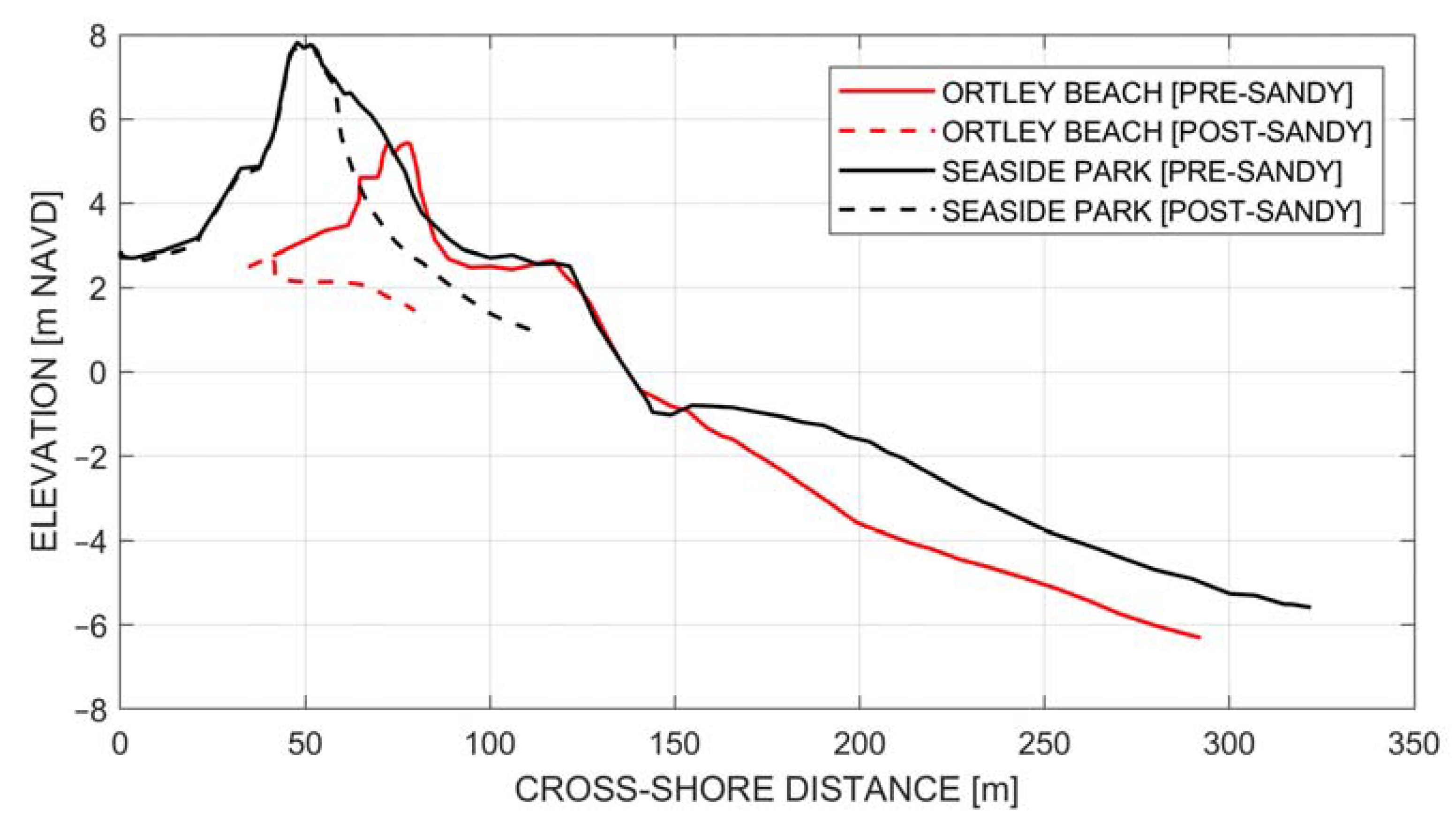
Figure 1. Pre- and post-Sandy beach profiles at Seaside Park (black) and Ortley Beach (red). Data reproduced from The Stockton University Coastal Research Center [16].
Jmse 09 01428 g001
Figure 2. Study area location. Alternating red and yellow lines depict NJ shoreline segments utilized by Lemke and Miller [26] to produce the storm erosion potential climatology. Segments are numbered from north to south, with #1 at Sandy Hook and #13 at Cape May. Black lines depict NJ County borders with the four Atlantic coastal counties labeled accordingly. Black markers depict NJBPN survey locations. Map coordinate system is NAD83/UTM Zone 18N in kilometers.
Jmse 09 01428 g002
Figure 3. Example of extracted morphologic parameters for surveyed pre- and post-storm profiles.
Jmse 09 01428 g003
Figure 4. Instances of dune volume loss, as a percentage of pre-storm dune volume, for eighteen storms in New Jersey.
Jmse 09 01428 g004
Figure 5. Spearman rank correlations between all predictor and impact variables. Black “X” markers indicate correlations of |ρ| > 0.4 and p < 0.05. Figure adapted from Beuzen et al. [19].
Jmse 09 01428 g005
Figure 6. Errors of subtrees of classification tree model with custom misclassification cost matrix (c = 2).
Jmse 09 01428 g006
Figure 7. Pruned classification tree with custom misclassification cost matrix (c = 2). Predictor parameters and the associated values used to split nodes are defined in the black diamonds and extending arrows. Terminal nodes are represented by blue, yellow, and red rectangles. At each terminal node, both the associated damage class and node ID are defined.
Jmse 09 01428 g007
Figure 8. Confusion matrices for the single classification tree (left) with custom misclassification cost matrix (c = 2) and for the classification tree ensemble (right) with custom misclassification cost matrix (c = 7). Confusion matrices provided based on the training (top), testing (middle), and combined (bottom) data sets.
Jmse 09 01428 g008
Figure 9. Sensitivity of model performance described by the misclassification rate of the testing set to ensemble size and maximum tree depth.
Jmse 09 01428 g009
Figure 10. Predictor importance estimates based on classification tree ensemble using selected variables (top) and all initially tested variables (bottom).
Jmse 09 01428 g010aJmse 09 01428 g010b
Table 1. Average SEI and PEI values, and associated return periods (tr), for eighteen historical storms in New Jersey. Return periods are based on frequency of occurrence curves created by Janssen [31].
EventSEISEI tr [yr]PEIPEI tr [yr]
October 199115345.267.35.2
January 199210172.264.44.1
December 199233262490.820
December 19948691.757.52.3
January 19967191.351.11.4
February 199814344.567.05.0
September 200310402.353.81.8
October 12 200517796.854.31.8
October 25 20058661.760.01.4
September 20069642.050.31.4
November 20076701.260.42.9
May 20089982.153.41.7
September 200817146.454.31.8
November 2009 (Vets)29861874.89.1
March 201012203.258.72.5
September 20105811.062.93.6
August 2011 (Irene)7881.473.38.2
October 2012 (Sandy)30561911949
Table 2. List of extracted morphologic parameters.
ParameterDefinition
Berm width (bwidth)Horizontal cross-shore distance from dune toe to shoreline (MHW)
Berm volume (mhwvol)Volume of material seaward of dune toe and above MHW per alongshore unit
Foredune width (fwidth)Horizontal cross-shore distance from dune crest to dune toe
Foredune volume (fvol)Volume of material seaward of dune crest and above dune toe per alongshore unit
Dune volume (dvol)Volume of material seaward of dune heel and above dune toe per alongshore unit
Dune crest elevation (crestz)Primary dune peak elevation
Dune toe elevation (toez)Primary dune toe elevation
Dune crest “freeboard” (crestfb)Height of crest relative to storm maximum water level
Dune toe “freeboard” (toefb)Height of toe relative to storm maximum water level
Intertidal slope (islope)End point slope between MHW and MLW
Beach slope (bslope)End point slope between dune toe and MHW
Foredune slope (fslope)End point slope between dune crest and dune toe
Table 3. Classification of storm-induced dune impacts based on quantitative changes.
Damage ClassDefinition
MajorDune volume loss > 40%
ModerateDune volume loss 5–40%
MinorDune volume loss < 5%
Table 4. Node statistics for pruned classification tree.
Node IDAssigned ClassNumber of Observations in Each Damage Class Based on Known Data
MinorModerateMajorTotal
1Minor394 (96.8%)12 (2.9%)1 (0.2%)407
2Major3 (50.0%)0 (0.0%)3 (50.0%)6
3Moderate1 (16.7%)5 (83.3%)0 (0.0%)6
4Moderate2 (25.0%)5 (62.5%)1 (12.5%)8
5Minor29 (87.9%)4 (12.1%)0 (0.0%)33
6Minor54 (96.4%)2 (3.6%)0 (0.0%)56
7Major2 (20.0%)3 (30.0%)5 (50.0%)10
8Moderate9 (31.0%)19 (65.5%)1 (3.4%)29
9Minor9 (100.0%)0 (0.0%)0 (0.0%)9
10Major2 (7.4%)4 (14.8%)21 (77.8%)27
11Moderate0 (0.0%)6 (100.0%)0 (0.0%)6
Table 5. Characteristics of compiled morphological and storm parameters in combined (training and testing) data sets.
Parameter [Units]MinimumMeanMedianMaximumIQR *
Berm volume [m3/m]1.875.262.5420.156.1
Dune volume [m3/m]1.549.939.2281.746.2
Median grain size [mm]0.160.420.382.190.20
Dune crest elevation [m NAVD]2.25.15.17.81.6
Dune toe elevation [m NAVD]1.02.72.64.81.0
Storm Erosion Index551456106938711155
Peak Erosion Intensity24.365.960.6163.316.6
* Interquartile Range (IQR) defines the length from the first quartile (25th percentile) to the third quartile (75th percentile).
Publisher’s Note: MDPI stays neutral with regard to jurisdictional claims in published maps and institutional affiliations.