Article

Sedimentary Sequence, Evolution Model and Petroleum Geological Significance of Forced Regression: A Case Study of the Miocene Zhujiang Formation of the Pearl River Mouth Basin in the Northern South China Sea

1
School of Earth Sciences and Geospatial Information Engineering, Hunan University of Science and Technology, Xiangtan 411201, China
2
Hunan Provincial Key Laboratory of Shale Gas Resource Utilization, Hunan University of Science and Technology, Xiangtan 411201, China
3
School of Geosciences, Yangtze University, Wuhan 430100, China
*
Authors to whom correspondence should be addressed.
J. Mar. Sci. Eng. 2021, 9(11), 1298; https://doi.org/10.3390/jmse9111298
Submission received: 28 September 2021 / Revised: 14 November 2021 / Accepted: 17 November 2021 / Published: 19 November 2021
(This article belongs to the Special Issue Marine Measurements: Theory, Methods and Applications)

Abstract

:
Using 2D/3D seismic data and a large number of drilling and logging data and applying sequence stratigraphy, seismic sedimentology, and petroleum geology concepts, the characteristics of the sedimentary sequence of the forced regression have been analysed, the migration trajectory of the coastline have been reconstructed, the evolution model of the forced regression have been presented, and the significance for petroleum geology of the forced regressive sandbodies have been discussed. The falling stage systems tract (FSST) of the Zhujiang Formation present offlap high-angle oblique foreset reflection structure in the seismic profiles of the depositional trends and turbidite fan deposits with strong amplitude mound reflection structure are developed in the downdip direction of its front. The trajectory of migration of the shoreline shows a terraced downtrend in the direction of basin. The FSST is characterized by the shelf-edge delta without topset beds. The FSST was formed in the fall of relative sea-level. Five sets of foreset beds controlled by high-frequency relative eustatic were developed, therefore ordinal regressive overlap can be observed for the five sets of shelf-edge deltas in the depositional trends. The favourable reservoirs which were located close to the upper boundary of the falling stage systems tract and the basal surface of forced regression are sandbodies of the shelf-edge delta front and wave-dominated shoreface sands and the sandbodies of the turbidite fan. Those sandbodies favour the formation of lithologic oil–gas reservoirs by means of good trap sealing conditions, excellent oil–gas reserving performance, and effective oil source communication of fracture system.

1. Introduction

Sequence stratigraphy is widely used in the predictive exploration of petroleum, coal, and placer deposits, which is the third of a series of major revolutions in sedimentary geology [1]. In the process of the development and application of sequence stratigraphy, there are some new views, including the position of sequence boundary, the division of system tracts, and the definition and nomenclature of units and bounding surfaces. Posamentier [2] identified the lowstand shoreline sandbodies formed by forced regression and modified the classical Exxon conceptual model, but still regarded the bottom boundary of lowstand shoreline sandbodies as the sequence boundary. Hunt and Tucker [3] reconsidered the lowstand shoreline sandbodies of forced regressive deposits, and put forward the concept of forced regressive wedge systems tract (FRWST), highlighting that, after the relative sea level began to fall, the FRWST formed until it fell to the lowest point, and the sequence boundary forms when the relative sea level falls to the lowest point. Ultimately, the top boundary of the FRWST is the sequence boundary. Considering that the forced regression wedge system tract was formed during the period of relative sea-level fall, Plint and Nummedal [4] proposed the concept of falling stage systems tract (FSST) and further stated that the FSST is the offspring according to the transgressive systems tract. Catuneanu [5,6] re-defined the concept of FSST, pointing out that the FSST occurred in the period when the base level (relative sea-level) fell. Catuneanu and Zecchin [7] extended the concept of sequence to include all cycles bounded by recurring surfaces of sequence stratigraphic significance, irrespective of the origin of these surfaces. Catuneanu [8] pointed out that stratal stacking patterns provide the basis for the definition of all units and surfaces of sequence stratigraphy. The same types of stacking patterns may be observed at different scales in relation to stratigraphic cycles of different magnitudes. With the continuous improvement of sequence stratigraphy theory and method, it has also been widely used in reconstructing the paleogeographic setting, climatic conditions, and tectonic setting which, in turn, are important for the petroleum industry [9,10,11].
As an important petroleum basin in the northern South China Sea, the Pearl River Mouth Basin developed several sets of continuous offlap sedimentary units which is similar to that configurated by the forced regression during the deposition of Zhujiang and Hanjiang Formations in Miocene, and the units have the characteristics of shelf-edge delta [12,13,14,15,16,17,18]. Previous work interpreted the shelf-edge delta as lowstand wedge or lowstand delta deposits in the lowstand systems tract of the classical Exxon sequence stratigraphic model and discovered many lithologic reservoirs, such as PY35 and PY36 [12,13,14,15,16,18]. However, because of the lack of understanding of sedimentary sequence characteristics, no new breakthroughs have been made in oil–gas exploration in recent years. With the continuous improvement of the theoretical concepts of sequence stratigraphy and the wide acceptance of the falling stage systems tract, Xu [19], Chen [20], and Yu [6,21] proposed to consider lowstand wedge or lowstand delta deposits as FSST and discussed its identification characteristics; however, they did not describe exactly the characteristics of the sedimentary sequence and summarize the evolution model for these forced regressive deposits.
In view of this, we take the forced regression wedge of the Miocene Zhujiang Formation in the Pearl River Mouth Basin (PRMB) of the northern South China Sea (NSCS) as an example. By using a comprehensive three-dimensional seismic data set and a large number of drilling and logging datasets, we analyze the characteristics of the sedimentary succession, recover the migration trajectory of the coastline, review the evolution model, and discuss the significance of the forced regression sandbodies in petroleum geology. This is expected to enrich more exploration examples and identification features for the falling stage systems tract, as well as provide guidance for realizing new oil and gas exploration breakthroughs in this area as soon as possible.

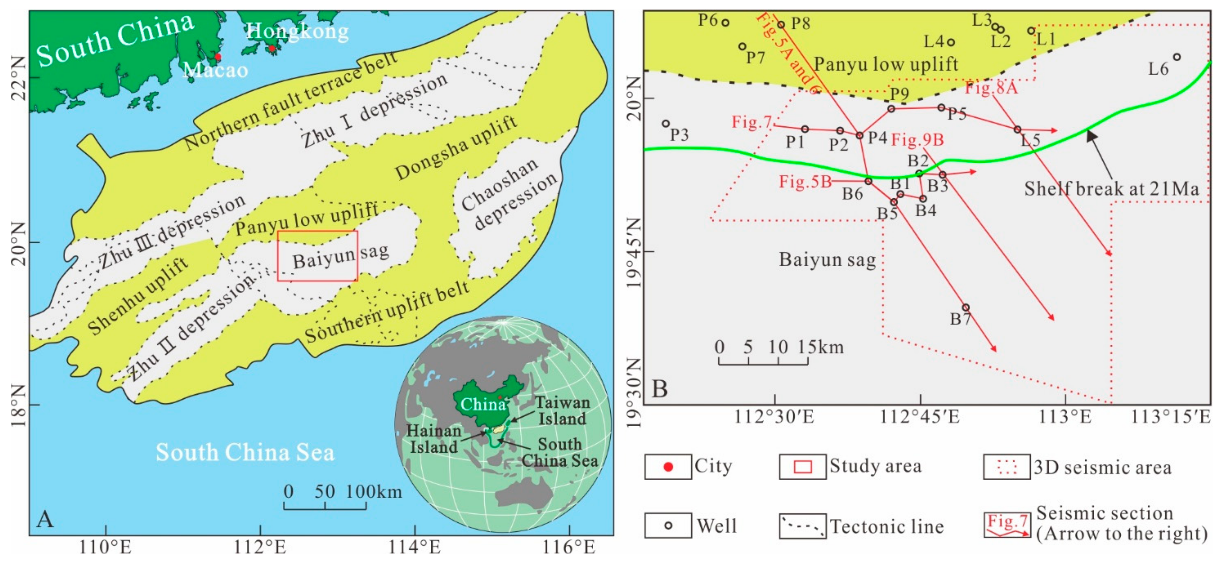
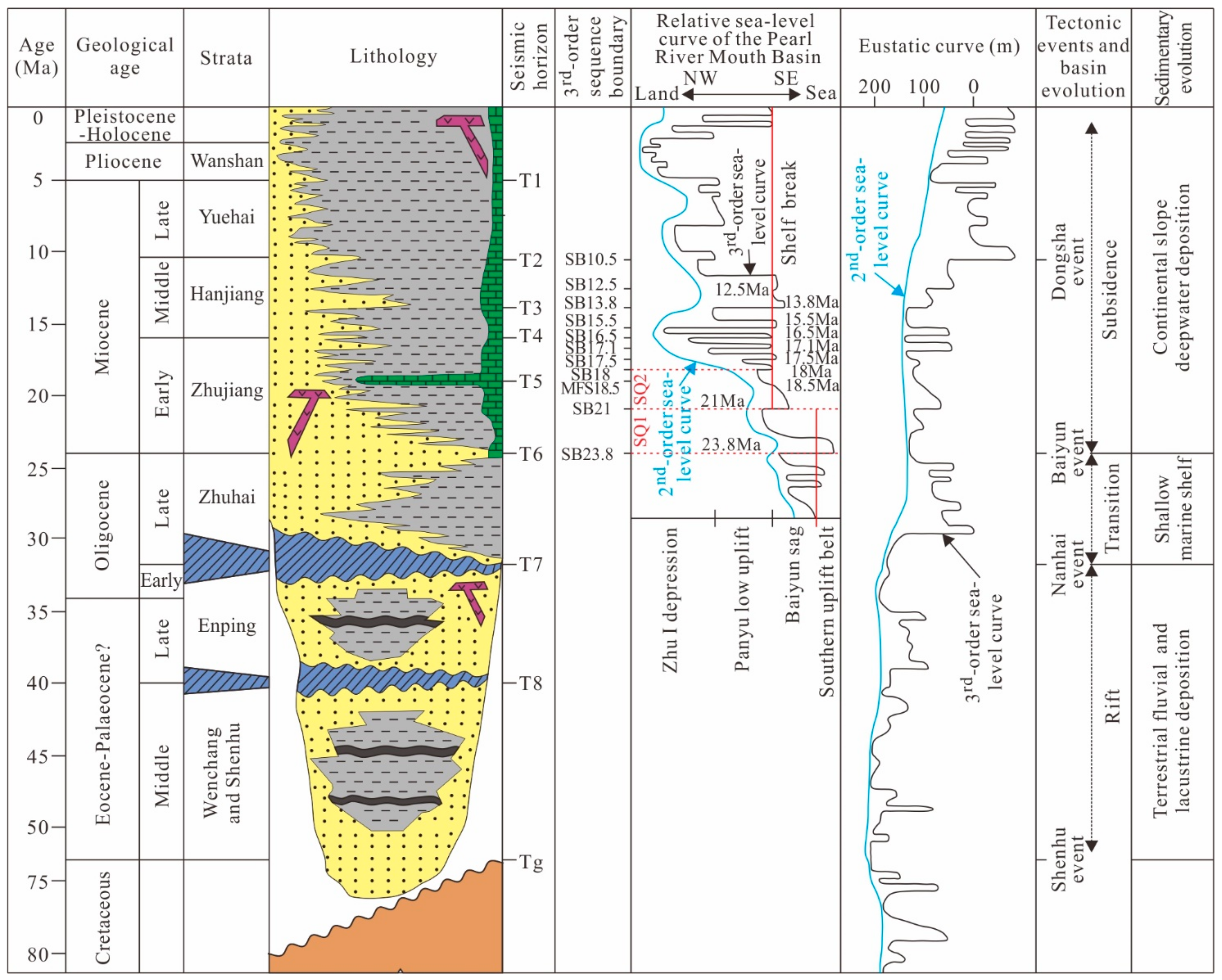
2. Geological Setting and Stratigraphy

The PRMB is one of the four major basins which developed in the NSCS during the Cenozoic [22,23,24]. The PRMB is located to the south margin of the South China continent between the Hainan and Taiwan islands, covering about 17.5 × 10⁴ km2 [25]. The PRMB can be divided into five tectonic units trending NE, which are the northern fault terrace belt, the northern depression belt (including Zhu I Depression and Zhu III Depression), the central uplift belt (including Shenhu uplift, Panyu low uplift and Dongsha uplift), the southern depression belt (including Zhu II Depression, Baiyun Sag and Chaoshan Depression), and the southern uplift belt [26] (Figure 1A). The Baiyun sag of the PRMB, which lies on the continental slope along the northern margin of the NSCS, is one of the largest hydrocarbon-generating sags in the PRMB, covering an area of approximately 1.2 × 10⁴ km2 at the depths of 200–2000 m [27,28]. The study area is located in the middle of the Baiyun sag, including a small part of the Panyu low uplift (Figure 1B).
Similar to many other passive continental margin basins, the evolution of the PRMB has experienced rift (57.5–32 Ma), transition (32–23.8 Ma), and subsidence (23.8–0 Ma) stages [29] (Figure 2). The Paleocene-early Oligocene rift stage was characterized by the well-developed half-graben structures [30,31,32]. The transition stage that occurred during the late Oligocene was influenced by a significant decrease in the intensity of the active normal faults [33,34]. The southward transition of the ridge in the center of South China Sea at 23.8 Ma, named the Baiyun event, led to the skipping of the continental shelf slope break from southern margin of the southern uplift belt to northern margin of the Baiyun sag; after this, the continental shelf break always kept near the southern side of the Panyu low uplift to the northern slope of Baiyun sag, such as shelf break at 21 Ma (Figure 1B). In the subsidence stage, a multi-period of tectonic collisional phases took place around the northern South China Sea. One of them was the NNW-directed underthrust of the Philippine Sea Plate at 10.5 Ma, named the Dongsha event in the region [35,36], which caused strong elevation and subsidence of the fault blocks and tenso-shear action of the strata in the PRMB. Two main collision phases between Taiwan and the continental margin of East China at 5–3 and 3–0 Ma ago may have resulted in two post-drift uplift events within the Dongsha region [36,37].
The Cenozoic strata in the Baiyun sag of the PRMB is 11 km thick and overlays the basement rocks of Cretaceous granites [24,38] (Figure 2). During the rift stage, terrestrial fluvial and lacustrine sandstones, mudsones, and coal deposits were deposited in the Shenhu, Wenchang, and Enping Formations of the Baiyun sag. The lacustrine mudstones and coal-bearing strata of the Wenchang and Enping Formations are the main hydrocarbon source rocks of the PRMB [39]. After the rift stage, a large shallow marine shelf delta developed in Zhuhai Formation of the Baiyun sag. The sandstone deposited at this stage accounts for about 50–60% of the volume of the rock and covers a large area, thus it is considered to be the most important reservoir rocks in the PRMB [39]. During the subsidence stage, deep-water depositional systems developed in the Zhujiang, Hanjiang, Yuehai, and Wanshan Formations and Quaternary strata in the Baiyun sag of the PRMB [36]. The Zhujiang Formation, which is the oldest of the Miocene sequences, is the main focus of this research. According to the seismic reflection structure characteristics of the PRMB, paleontological datings and the third-order relative global sea-level curve, six third-order sequence boundaries (SB23.8, SB21, SB18, SB17.5, SB17.1 and SB16.5) and a maximum flooding surface (MFS18.5) have been identified in the Zhujiang Formation [33,40,41,42,43]. The forced regressive deposits are beneath the SB21, therefore the strata of this study are the SQ1 and SQ2 sequences, which are between SB23.8 and SB18 (Figure 2).

3. Data and Methodology

Both multichannel 2D and high-resolution 3D seismic data used for this study were provided by Shenzhen branch of the China National Offshore Oil Corporation (CNOOC) (Figure 1B). The 3D seismic survey covered an area of approximately 3100 km2, with a bin size of 12.5 × 12.5 m2 in the inline and crossline directions. The frequency bandwidth of the data ranges from 15 to 70 Hz with a dominant frequency of 50 Hz, and the sampling interval is 2 ms. The seismic velocity of the Zhujiang Formation in Panyu low uplift-Baiyun sag is 3500 m/s, and the vertical resolution is approximately 15 m. The vertical scale for all the seismic profiles shown in this paper is round trip time, and all of the original data were interpreted in the workstation with Geoframe 4.5. There are 22 wells involved in this study and all of them possess a complete suite of log and lithology data, including P1, P2, P6, and B4 wells, which also have core data (Figure 1B). Furthermore, 15 of these wells are in the shallow waters and the rest are in the deep-water region.
Firstly, according to the core observation and description and the sedimentary sequence analysis of a single well, sedimentary facies and the stacking pattern of parasequence for the forced regression could be determined; Secondly, the characteristics of seismic facies and sequence evolution for the forced regression were determined by detailed correlation of section of line series and interpretation for the seismic reflection structure and its attribute property; then, on the basis of seismic profile data, the changing pattern for the trajectory of shoreline migration of the forced regressive deposits could be determined by recovering the migration trajectory of shoreline; Finally, in the light of the latest principles of sequence stratigraphy concepts, the evolutionary model of the sedimentary sequence for the forced regression and its related systems tract were summarized and the significance of the forced regression and related sedimentary sandbodies for petroleum geology could be assessed.

4. Results

4.1. Depositional Systems or Facies Associations

4.1.1. Core Lithofacies Characteristics

Sedimentary structure characteristics of the core which is from the four coring wells in the study area have been detailed observed and described, it has been known that the Panyu low uplift and Baiyun sag in the PRMB have characteristics of both multitudinal rock types and complex sedimentary structures. The main rock types are: (1) Reddish-brown pebbly sandstone and medium-coarse grained sandstone, which are the main rock types of a distributary channel or incised valley channel deposited in delta plain, the sandstone with subangular to subrounded poorly sorted clasts are common (Figure 3A,B); (2) Grey or yellow-grey fine-grained sandstone and silty fine-grained sandstone, which are the main rock types of underwater distributary channel or mouth bar developed in delta front, the clasts are subrounded well sorted (Figure 3D–H); (3) Red-brown mudstone, which is with iron-bearing nodules (Figure 3C), reflecting that the sedimentary environment is exposed and oxidized. The main sedimentary structures are as below: (1) large-scale massive (Figure 3B) and plate cross-bedding (Figure 3A), which are developed in the distributary channel in delta plain on the strong hydraulic conditions, but also horizontal bedding (Figure 3C), which are developed in inter-distributary bay or floodplain under the weak hydraulic conditions, are common. (2) Both parallel bedding (Figure 3F) and wedge-shaped cross bedding (Figure 3G), which are developed in submerged a distributary channel in the delta front on the strong hydraulic conditions, and small cross bedding (Figure 3D), which are developed in delta front under the relatively weak hydraulic conditions, can usually be seen. At the same time, the reverse graded bedding (Figure 3E), which is the main character of the mouth bar, is obviously observed. (3) The bioturbation structures (Figure 3D,E) consist of abundant strong and horizontal burrows (Figure 3E), indicating that the depositional environment is a neritic province with a relatively weak hydraulic condition and the depth of water is relatively deep. (4) The deformation of the argillaceous belt (Figure 3H) is so intense that the slide and slump are usually seen, indicating that the depositional environment is a continental slope with a relatively steep gradient. Based on the lithofacies characteristics of the cores mentioned above, it can be inferred that the study area is located in a shallow delta, where the water is relatively deep and, at the same time, it is located in a continental shelf with a gradient. Consequently, the study area may be a shelf-edge delta.

4.1.2. Sedimentary Sequence Characteristics of Single Well

The log facies have been studied based on the combination of the morphological characteristics of logging curves and the analysis of the lithologic characteristics and structural features. A comprehensive column of sediment and sequence for two single wells has been established according to the stacking patterns of the parasequence (Figure 4). Two single wells are Well P1, which is landward and located on the 21 Ma shelf slope break, and Well B5, which is seaward and located beneath the 21 Ma shelf slope break. As can be seen in Figure 4, the logging curves of distributary channel in delta plain and underwater distributary channel in delta front are a cylinder shape and a bell shape. Furthermore, it is mainly the cylinder shape and with a relatively wide range for the distributary channel, whose lithology is characterized by gravel-bearing coarse-grained and medium-coarse sandstone in delta plain (Figure 3A,B), while it is generally a combination of the cylinder shape and bell shape and with a relatively narrow range for the underwater distributary channel, whose lithology is dominated by fine sandstone in the delta front (Figure 3F,G). The well logging curves of mouth bar are funnel shape and have the characteristics of the reverse graded bedding (Figure 3E). The logging curves of floodplains, interdistributary bays, and prodelta, whose lithology are mudstone-dominated from linear shape. Due to the influence of high-frequency eustatic cycles, the logging curves of a large set of prodelta mud shows a series of fluctuations which are slightly funnel-like (prodelta mud of well B5 in Figure 4), and vertical overlaps of several parasequences are obvious. During the development of the transgressive systems tract of SQ1 sequence, because the shelf slope break zone is located on the south of the study area [16], the study area shows a sedimentary background with low accommodation space. Further, the parasequence take the exposed erosion surface which corresponds to the flooding surface as its boundary. The boundary is formed during the descending half-cycle of the base level (relative sea-level), while the parasequence is formed during the ascension half-cycle of the base level (relative sea level). Overall, the transgressive systems tract vertically presents a retrogradational parasequence set (Figure 4, Well P1 and Well B5). During the period of the highstand systems tract of SQ1 sequence, the shelf slope break zone transited from the southern part outside the study area to the northern part of the study area [44] due to the lag effect of the Baiyun movement. Here, the study area presented a sedimentary background with high accommodation space. Ultimately, the parasequence takes the flooding surface as the interface, and its interface is formed during the ascension half-cycle of the base level (relative sea level), while the parasequence is formed during the descending half-cycle of the base level (relative sea level). Generally, the highstand systems tract presents a progradational parasequence set vertically (Figure 4, Well P1 and Well B5). Due to the decline of relative sea level, falling stage systems tract of the SQ1 sequence in the well P1 is characterized by the parasequence formed during the ascension half-cycle of the base level (relative sea-level), and the falling stage systems tract shows vertically a progradational parasequence set (Figure 4, well P1). However, because of the high accommodation space, the falling stage systems tract of the SQ1 sequence in the under part of Well B5 is characterized by the parasequence formed during the descending half-cycle of the base level (relative sea-level). Moreover, with the continual decline of the sea level, the high accommodation space is transformed into the low accommodation space, therefore the falling stage systems tract of the SQ1 sequence in the upper part of Well B5 is characterized by the parasequence formed during the ascension half-cycle of the base level (relative sea-level) and the systems tract shows stacking patterns of progradational to aggradational parasequence set (Figure 4, well B5). The transgressive systems tract of SQ2 sequence is characterized by parasequence formed during the ascension half-cycle of the base level due to the low accommodation space in the early stage, while it is characterized by parasequence formed during the descending half-cycle of the base level due to the high accommodation space in the late stage, and it is characterized by the retrogradational parasequence set as a whole (Figure 4, Well P1 and Well B5). The highstand systems tract of SQ2 sequence is characterized by parasequence formed during the descending half-cycle of the base level due to the high accommodation space, and it is characterized by progradational parasequence set (Figure 4, Well P1 and Well B5).

4.1.3. Seismic Facies Characteristics

The external form of the falling stage systems tract in the study area is a mound type, according to the seismic profile (Figure 5). The seismic facies unit presents a progradational configuration in the depositional trends (Figure 5A), while a divergent fills in the vertical depositional trends (Figure 5B). The thickness of the seismic facies unit changes from small to large and then to small in the depositional trends (Figure 5A), and they are thick in the middle and thin on both sides in the vertical depositional trends (Figure 5B). Meanwhile, it is fan-shaped in the plane (Figure 6A). As above, the falling stage systems tract has the typical characteristics of delta deposits. For the detailed observations, the characteristics of the internal structure are shown as follows: the characteristics of oblique progradational reflection with high angle, lacking the sedimentary units of the topset beds and developing only the sedimentary units of the foreset and bottomset beds (Figure 5A), and all of these are the sedimentary characteristics of the shelf-edge delta. The seismic termination for the top boundary of the falling stage systems tract (SB21) shows toplap, and the boundary is characterized by the subaerial exposure and erosion of the sequence boundary. However, the seismic termination for the basal surface of forced regression (BSFR) shows downlap, and the surface is characterized by stratigraphic integrity (Figure 5A). The upper part of the falling stage systems tract has strong amplitude seismic reflection, which infers delta front sediments with high sand content, while the lower part present disorder and weak amplitude seismic reflection, which infers the prodelta sediments dominated by argillaceous sediments. In addition, the reflective structure with strong amplitude can be seen locally, and the external geometric shape is a mound, and the flat shape consists of small lobes (Figure 5A and Figure 6B). All of these infer turbidite fan deposits.

4.2. Sequence Stratigraphic Systems and Depositional Evolution

4.2.1. Sedimentary Sequence Characteristics in the Depositional Trends

The falling stage systems tract presents oblique progradational reflection configuration with a high angle, which is more than 3 degrees in the seismic profiles, which is depositional trends [21]. The delta plain facies of the topsets are absent and the bottomset beds are tangentially oblique to the lower boundary (Figure 7). It also reflects both a characteristic of delta sedimentary environment with high-energy and a rapid decline in relative sea-level. Other characteristics that can be seen from Figure 7 are as follows: (1) the deposition thickness of transgression and highstand systems tract in SQ1 sequence are relatively thin; (2) the two systems tract present a phase axis from the seismic profile; (3) the phenomenon of retrogradation and progradation caused by delta plain and front deposits can be clearly seen from the profiles in a series of wells. It has been inferred that all of the characteristics above may be related to the structural event of Baiyun movement in 23.8 Ma and the subsequent sedimentary effect [44]. The falling stage systems tract of the SQ1 sequence is characterized by the seaward progradation of five phases foreset beds which present offlap one by one, accompanying with the development of shelf-edge delta front deposits, prodelta deposits, and turbidite fan deposits with strong amplitude reflection structure in the downdip direction of the front (Figure 7). With the end of the SQ1 sequence, the relative sea-level began to rise slowly until the maximum regression surface (MRS) formed, and the lowstand systems tract deposits of normal regression developed. Further study shows that the lowstand systems tract possess obvious characteristics of wedge which have a strong amplitude reflection at the top and S-shaped foreset reflection structure internally (Figure 7). Generally speaking, the lowstand systems tract mentioned above show the characteristics of lowstand wedge delta deposits. Later, the relative sea level rises quickly until the maximum flooding surface MFS18.5 is formed, and the transgressive systems tract of SQ2 sequence developed. The depth of the transgressive systems tract deposits near the shelf slope break in the three-dimensional seismic work area of the study area were relatively thin, and even the sequence boundary SB21 is coincided with the maximum flooding surface MFS18.5 in some areas. However, it is obviously thicker in the direction of the sea and the direction of the land. This may be related to the sedimentary environment of the systems tract, i.e., the delta deposits are mainly in the continental direction, while the deep-water sludge deposits are mainly in the seaward direction. On the profiles of a series of wells, it can be seen that the depositional system is obviously thick at both sides and thin in the middle, and it shows facies (delta plain, front and prodelta) migration of landward retrogradation in the direction facing continent (Figure 7). Then, the sea level rises slowly until the boundary of the SB18 sequence formed, and the highstand systems tract of the SQ2 sequence developed. At this time, the accommodation space is relatively high, and the seismic profile shows the characteristics of weak amplitude foreset reflection structure, and the profiles of a series of wells present a seaward progradation of facies (delta front and prodelta) (Figure 7).

4.2.2. Sedimentary Sequence Characteristics in the Vertical Depositional Trends

The falling stage systems tract presents one or more in-phase axis (Figure 5B and Figure 8) on the seismic profiles that are perpendicular to the depositional trends. One seismic reflection axis can be found in the site which is near the provenance or far from the provenance (Figure 8), while more line-ups which suggest the deposits of multi-stage foreset beds can be seen in the main sedimentary area of the falling stage systems tract (Figure 5B). Figure 8 is a profile of a well series which is not only near the provenance and landward but also locates above the 21 Ma shelf slope break landward. It can be seen from Figure 8 that the SQ1 sequence, which is characterized by delta front deposits developed transgressive, highstand, and falling stage systems tract, and that the falling stage systems tract developed only the first-stage foreset beds deposits due to its proximity to the provenance area. Then, the sedimentary period of SQ2 sequence began. On the one hand, a profile of the well series mentioned above is near the provenance, landward, and locates above the 21 Ma shelf slope break landward, and, on the other, the lowstand systems tract deposits of SQ2 sequence are located beneath the 21 Ma shelf slope break zone and seaward (Figure 7), therefore no record of the lowstand systems tract deposits of the SQ2 sequence were found on the profile of well series. Here, the sequence interface of SB21 overlapped by the maximum regression surface (MRS). Immediately after, the transgressive systems tract deposits of SQ2 sequence formed along with rapid rise of relative sea level. Because the section mentioned above is close to the provenance area, the corresponding seismic profile presents strong amplitude and good continuity, and the profile of the well series presents delta plain in the lower part and delta front in the upper part and facies migration of retrogradation on the whole (Figure 8). Finally, the relative sea level rose slowly, and the rate of sedimentary alimentation was higher than the relative sea level rise rate. At the same time, the high systems tract of SQ2 sequence formed. For this, the corresponding seismic profile present weak amplitude and good continuity, and the profile of well series present prodelta in the lower part and delta front in the upper part and facies migration of progradation on the whole (Figure 8).
Because of the gradient of the continental slope which may be different at different localities in the same area and the influence which are caused by the location of the main stream of the delta deposits, the sedimentary diversity of the falling stage systems tract under the shelf slope break may be more remarkable in the vertical depositional trends. The falling stage systems tract of SQ1 sequence developed five sets of foreset wedges in the western part of the study area. Furthermore, the five sets of foreset wedges are 270 m thick, medium-fine sandstone and gravel-bearing, and they have obvious characteristics of foreset reflection structure (Figure 5A and Figure 7), while there are only two sets of foreset wedges in the eastern region. The two sets of foreset wedges are about 160 m thick and large-scale foreset reflection structure cannot be seen in the corresponding seismic profiles. Here, wave-dominated shoreface sands can be seen in the lower part of the falling stage systems tract (Figure 9A,B). In order to confirm the existence of wave-dominated shoreface sands in the vertical depositional trends and further determine the development range of shelf-edge deltas and turbidite fans, root mean square amplitude attributes were extracted 30 ms downward from the top surface of the falling stage systems tract (21 Ma) (Figure 9C) and 30 ms upward from the basal surface of forced regression (Figure 9D). From Figure 9C, the western part of the study area which is under the 21 Ma shelf slope break zone presented obvious and large lobes marked by strong amplitude around Wells B3, B4 and B6, and the transition is carried out eastward into bands of strong amplitude and small lobes which are also with strong amplitude. This shows that the main channel of the delta is in the western part of the study area while the sub-channel is in the eastern part of the study area. In Figure 9D, there is an obvious area marked by a weaker root mean square amplitude attribute in the seaward direction of the 21 Ma shelf slope break zone, while there are two regions which are present a flower-like manner in the plane and with relatively strong amplitude from the two shelf-edge deltas to the center of the basin. It shows that the lower part of the foreset beds near the bottom of the falling stage systems tract is a prodelta argillaceous deposit, while the upper part of the foreset beds near the top of the falling stage systems tract is a sand-rich delta front deposit, and gravity flow turbidite fan deposits often occur in the front of the shelf-edge delta which is near the center of the basin.

4.2.3. Trajectory of Shoreline Migration

The migration trajectory for the shoreline is a method to determine the type of system tract. Based on the seismic profiles, Catuneanu [6] proposed the change patterns of shoreline migration trajectory in different system tracts, discussed the corresponding stratigraphic stacking patterns for different system tracts, and pointed out that the supply capacity for the sediment and the variation for accommodation space were the main controlling factors for the change of shoreline migration trajectory. Based on the seismic profiles which are in the depositional trends, and combined with the evolution characteristics of sedimentary sequence for single well and the variation characteristics of stratigraphic cycles, five sets of sedimentary strata without erosion in foreset bed are successively restored in order by using the method of extending reversely the seismic reflection axis interpretation results of the foreset beds along the depositional trends. Then, we assumed that the erosion base level is parallel to the maximum flooding surface MFS18.5, that is, the shoreline located at the tangent point between the erosion base level of each set of foreset bed and the set of foreset bed (shown in the red circle of Figure 10C). From Figure 10, the shoreline migration trajectories for the five sets of foreset beds in the falling stage systems tract in SQ1 sequence which situated in the Zhujiang Formation in Panyu low uplift and Baiyun sag of the PRMB terraced down towards the basin (shown in the red circle of Figure 10C). It shows that the relative sea-level gradually declines during the period when the falling stage systems tract formed, and the rate of sediment supply is much larger than the accommodation changing rate. That is to say, the clastic sediments advanced into the basin continuously as the clastic sediments carried out the downcutting continuously in the area near the provenance.

5. Discussion

5.1. Evolution Model of Forced Regression

Based on the analysis of the above-mentioned forced regression and the sedimentary sequence characteristics of the system tracts which are related to forced regression, combined with the changing pattern of the migration trajectory of shoreline, the change characteristics of the relative sea-level of the sequence SQ1 and SQ2 in Zhujiang Formation in the PRMB are summarized, and the sedimentary sequence evolution model of the forced regression in the Zhujiang Formation of the PRMB and the NSCS is established (Figure 11). The overview is as follows: With the end of highstand systems tract of SQ1 sequence, the relative sea level reaches the highest point h1. Then, forced regression began to deposit at the onset of relative sea level fall. During the T1 period, the sea level dropped from position 0 to position 1, the foreset ① was deposited (Figure 11A). The shelf-edge delta with delta plain, delta front, and prodelta is developed. During the T2 period, the sea level dropped from position 1 to position 2, the foreset ② was deposited (Figure 11B). Delta plain, delta front, and prodelta are developed in turn, but the delta plain is obviously smaller than that of the foreset ① (Figure 11B). During the T3 period, the sea level dropped from position 2 to position 3, the foreset ③ was deposited (Figure 11C). Only the delta front and the prodelta are developed in the shelf-edge delta. Due to the rapid decline of the relative sea level and the instability of delta front, the gravity flow turbidite fan connected by the incised canyon is developed. During the T4 period, the sea level dropped from position 3 to position 4, and the foreset ④ was deposited (Figure 11D). A shelf-edge delta with delta front and prodelta is developed, below which an incised canyon and turbidite fan are developed (Figure 11D). Wave-dominated shoreface sands parallel to the shoreline are developed in the without delta area (Figure 9A–C). During the T5 period, the sea level dropped from position 4 to position 5, the foreset ⑤ was deposited (Figure 11E). Delta front, prodelta, incised canyon, turbidite fan, and wave-dominated shoreface sands are developed (Figure 9A–C and Figure 11E). At this time, the relative sea level dropped to the lowest point h2, the forced regression deposition was completed, and the exposed erosion unconformity surface SB21 was formed (Figure 10). Here, the sedimentary process of SQ1 sequence was finished and the SQ2 sequence deposits began.

5.2. Significance for Petroleum Geology

The foreset sandbodies formed during the sea-level fall covered the neritic mudstone of the underlying highstand systems tract, and then the foreset sandbodies are covered by the dark mudstone caused by the transgression and highstand systems tract of the later sequence. For this, it may be a favourable place for the formation of large-scale oil–gas reservoirs, due to the favourable oil-generating conditions, good reservoir space, and excellent caprock sealing [45]. The root mean square amplitude attributes (Figure 9C) have been extracted from the top surface (21 Ma) of the falling stage system tracts 30 ms down, and Well B3, Well B5 and Well B6 have been drilled (Figure 4, Figure 7, Figure 8 and Figure 10A). It has been found that the sandbodies in the SQ1 sequence falling stage systems tract of the Zhujiang Formation in Panyu low uplift and Baiyun sag are well developed. Furthermore, the sandbodies of the shelf-edge delta front present fan-shaped distribution and the wave-dominated shoreface sands present strip-shaped distribution. These sandbodies are well trapped by the structure contour map of the maximum flooding surface of the overlying SQ2 sequence (Figure 12). Meanwhile, these foreset sandbodies, which are relatively far away from the provenance, are intermingled with the prodelta mud or hemipelagic mud of SQ1 sequence highstand systems tract which lie beneath those foreset sandbodies and the predelta or hemipelagic dark mudstone of SQ2 sequence transgressive systems tract and highstand systems tract which are on those foreset sandbodies. Moreover, controlled by stratum pinching of 21 Ma shelf slope break zone, the sealing conditions of the trap are excellent (Figure 9C, Figure 11 and Figure 12). In addition, the oil testing results in the oilfield show that the foreset bed sandbodies of stage 2 and 3 in the SQ1 sequence falling stage systems tract in the western part of the study area belong to GAS1 and GAS2 sand sets, which are the main oil reservoirs in the area, and the sandbodies are with good reservoir conditions. Meanwhile, drilling data reveals that the sandbodies developed very well (Figure 10A). Moreover, the turbidite fan sandbodies are on the argillaceous layers of shelf delta or hemipelagic mudstones of continental slope in SQ1 sequence highstand systems tract and under the hemipelagic mud or the prodelta deposited in the shelf-edge delta of falling stage systems tract (Figure 9D, Figure 11 and Figure 12). For these, good sealing conditions and good stratigraphic and lithologic traps formed. At the same time, there are many faults which are good oil-source communication conditions and can transport oil and gas from the south oil-generating sag to the forced regression sandbodies and turbidite fan sandbodies in the Panyu low uplift and Baiyun sag (Figure 12). Therefore, the research and analysis of the sedimentary sequence characteristics of the falling stage systems tract can afford positive guidance for the exploration of lithologic reservoirs in the continental shelf slope break zone.

6. Conclusions

The major conclusions of this study related to forced regressive deposits are as follows:
(1)
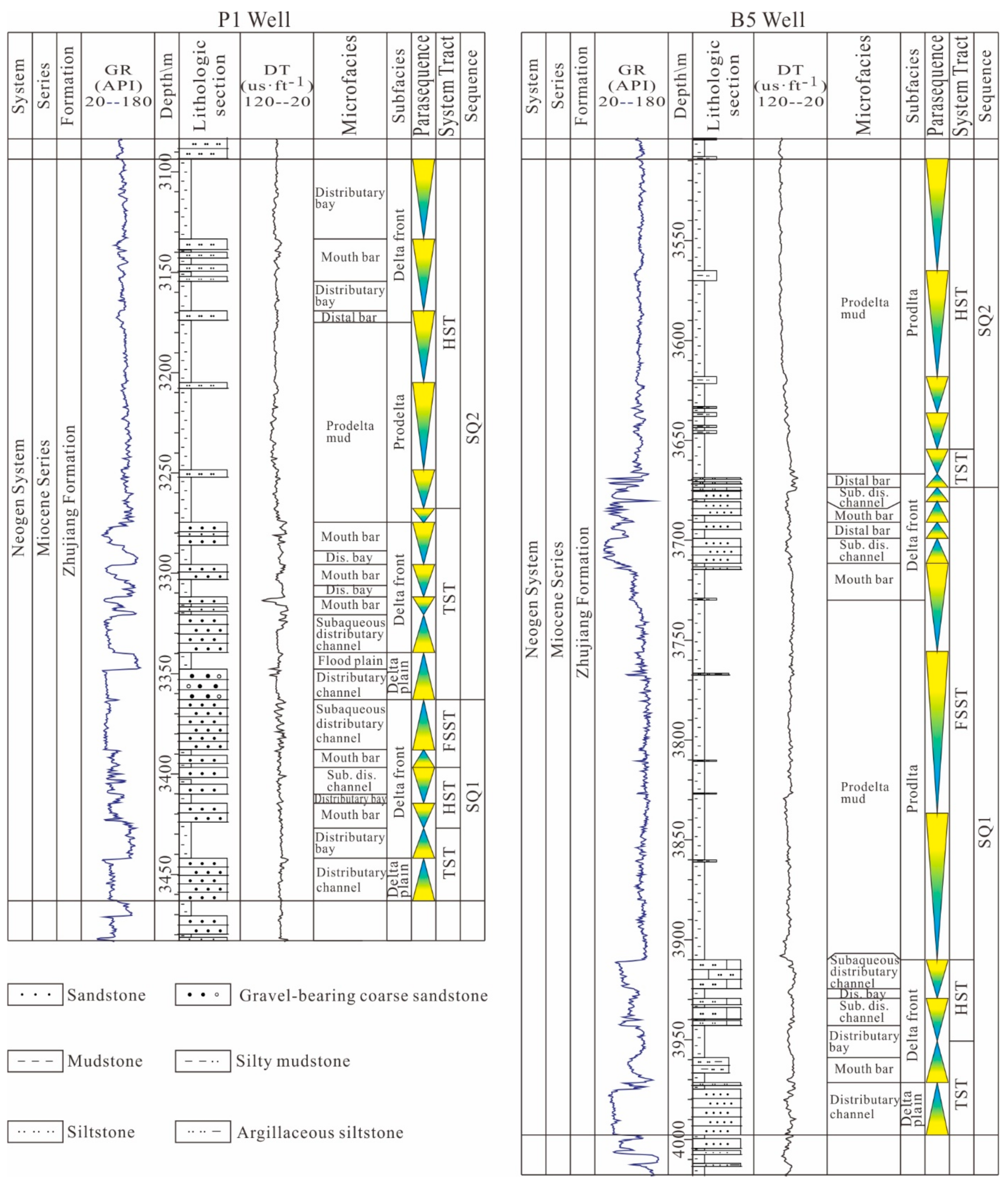
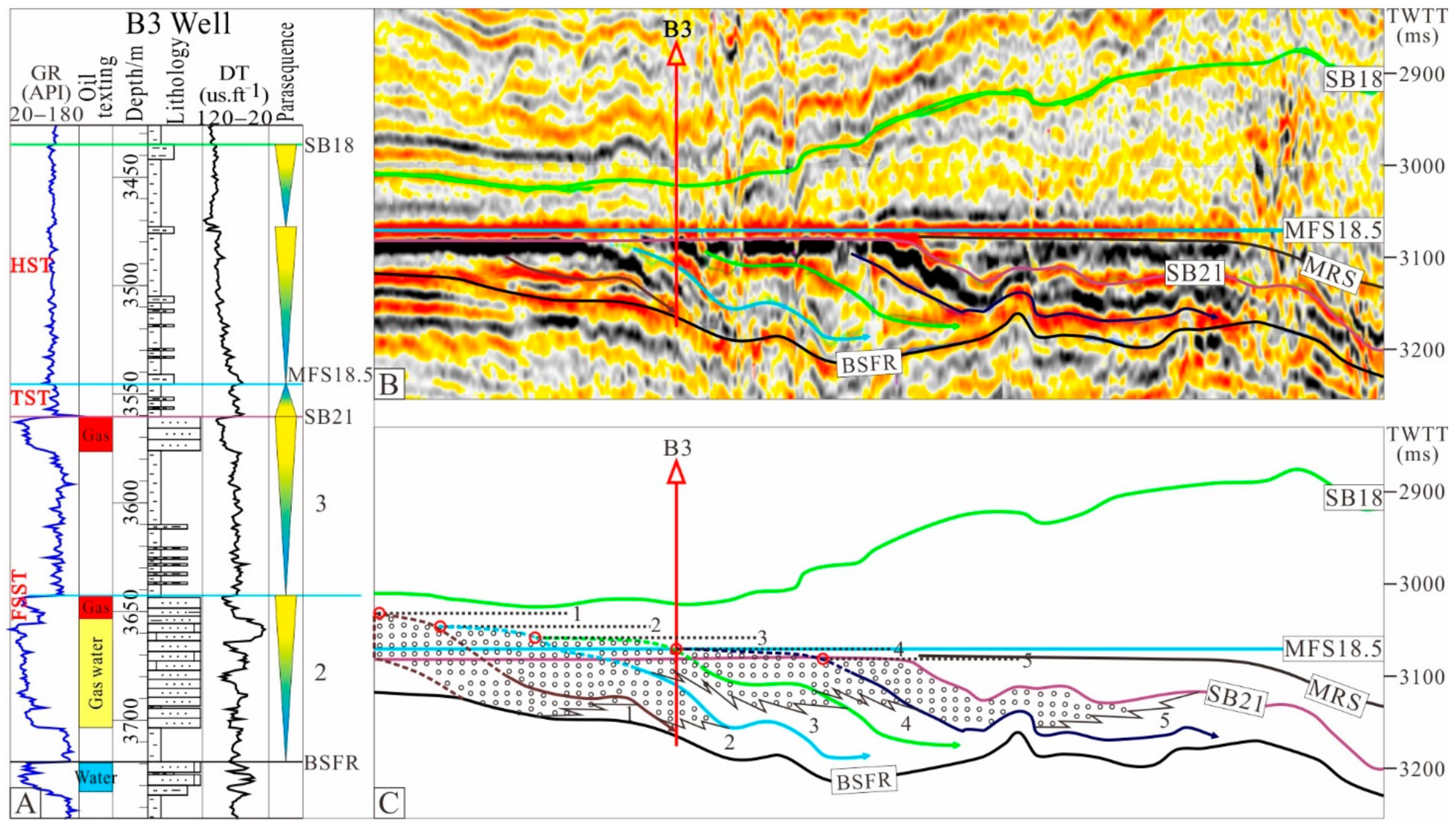
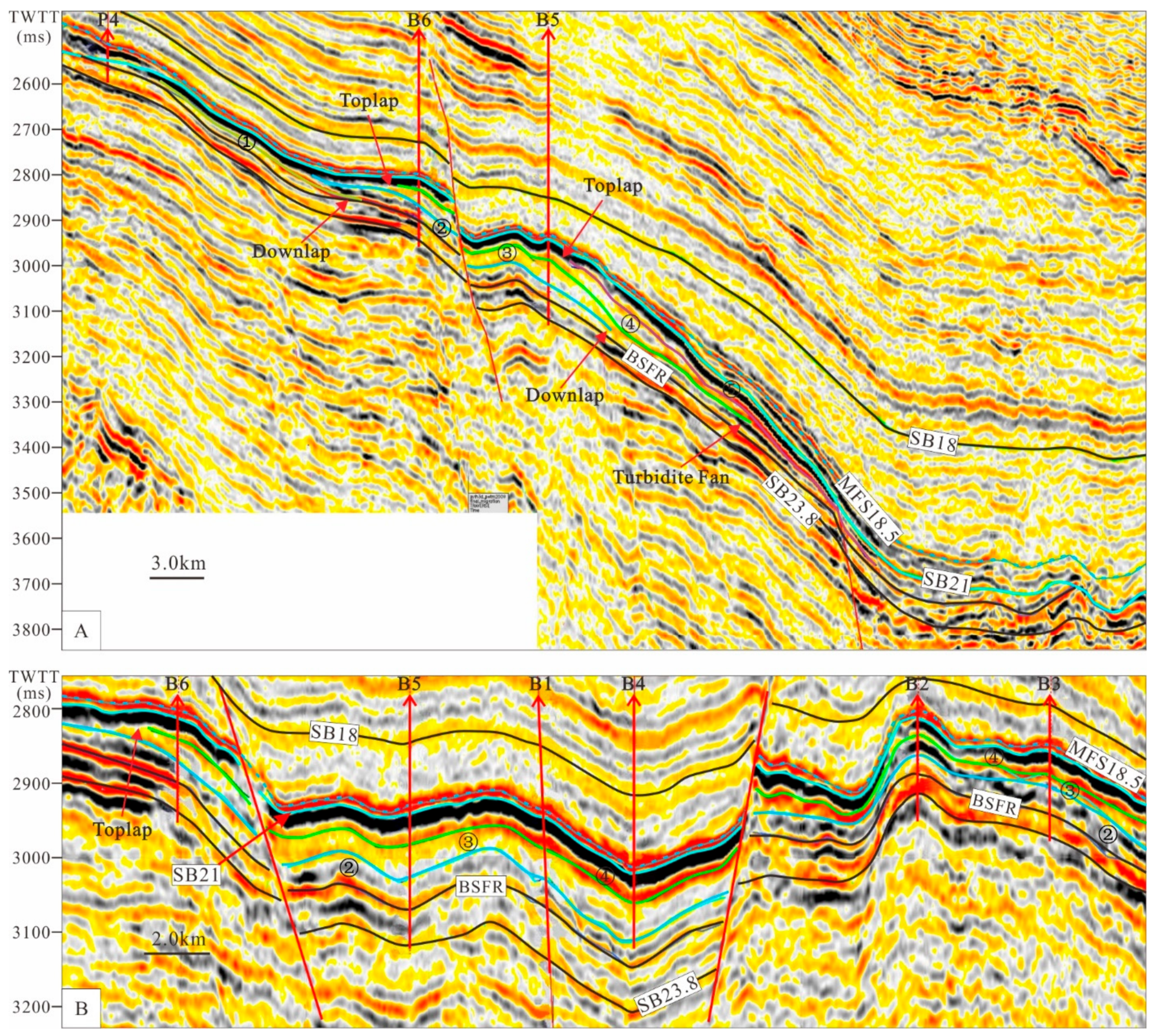
The falling stage systems tract of the Zhujiang Formation in the PRMB present an offlap high-angle oblique foreset reflection structure that inferred shelf-edge delta without topset beds in the depositional trends. The drilling and logging data show many reverse cycles which are combined by prodelta mud, distal bar, mouth bar, and underwater distributary channel in the falling stage systems tract.
(2)
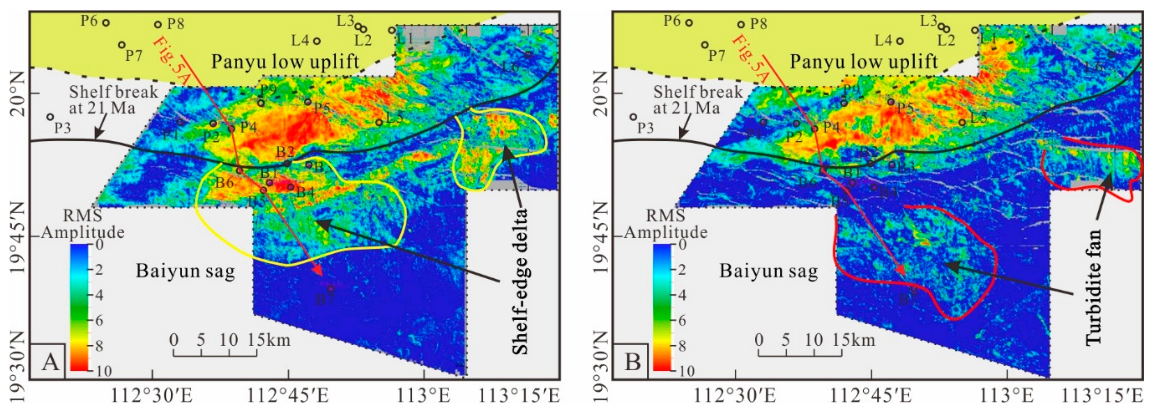
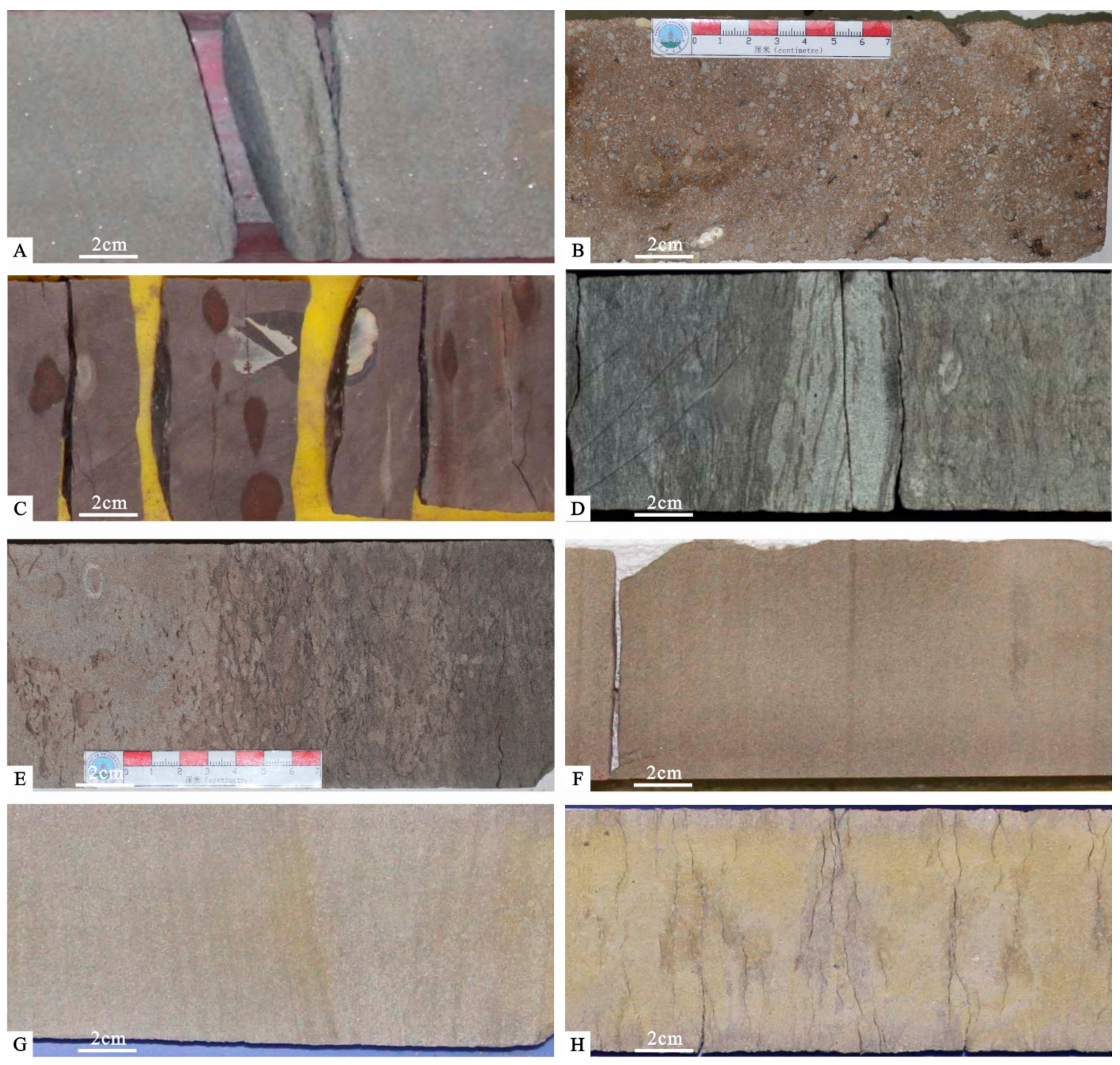
The features of bioturbation, horizontal burrows, muddy strip deformation, slide and slump, which are typical in slope areas, can be observed in the cores of the falling stage systems tract of the Zhujiang Formation in the PRMB. Turbidite fan deposits characterized by strong amplitude mound reflection structure are developed in the downdip direction of the front of the falling stage systems tract.
(3)
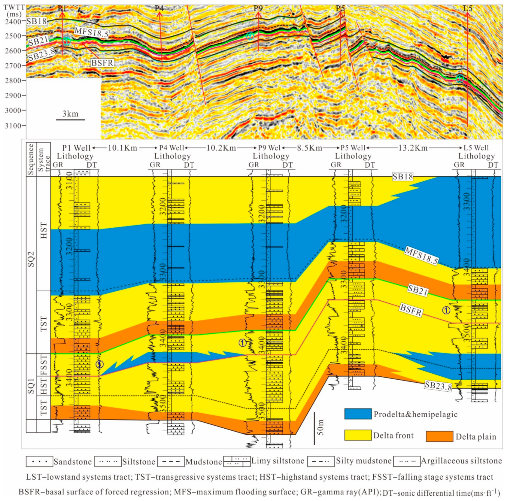
The falling stage systems tract of the Zhujiang Formation in the PRMB is formed in the sedimentary background with low accommodation space, and the parasequence is formed during the ascension half-cycle of rising base level (relative sea-level). The falling stage systems tract present a stacking pattern with progradational to aggradational parasequence set. The migration trajectory of shoreline shows terraced downtrend in the direction of basin.
(4)
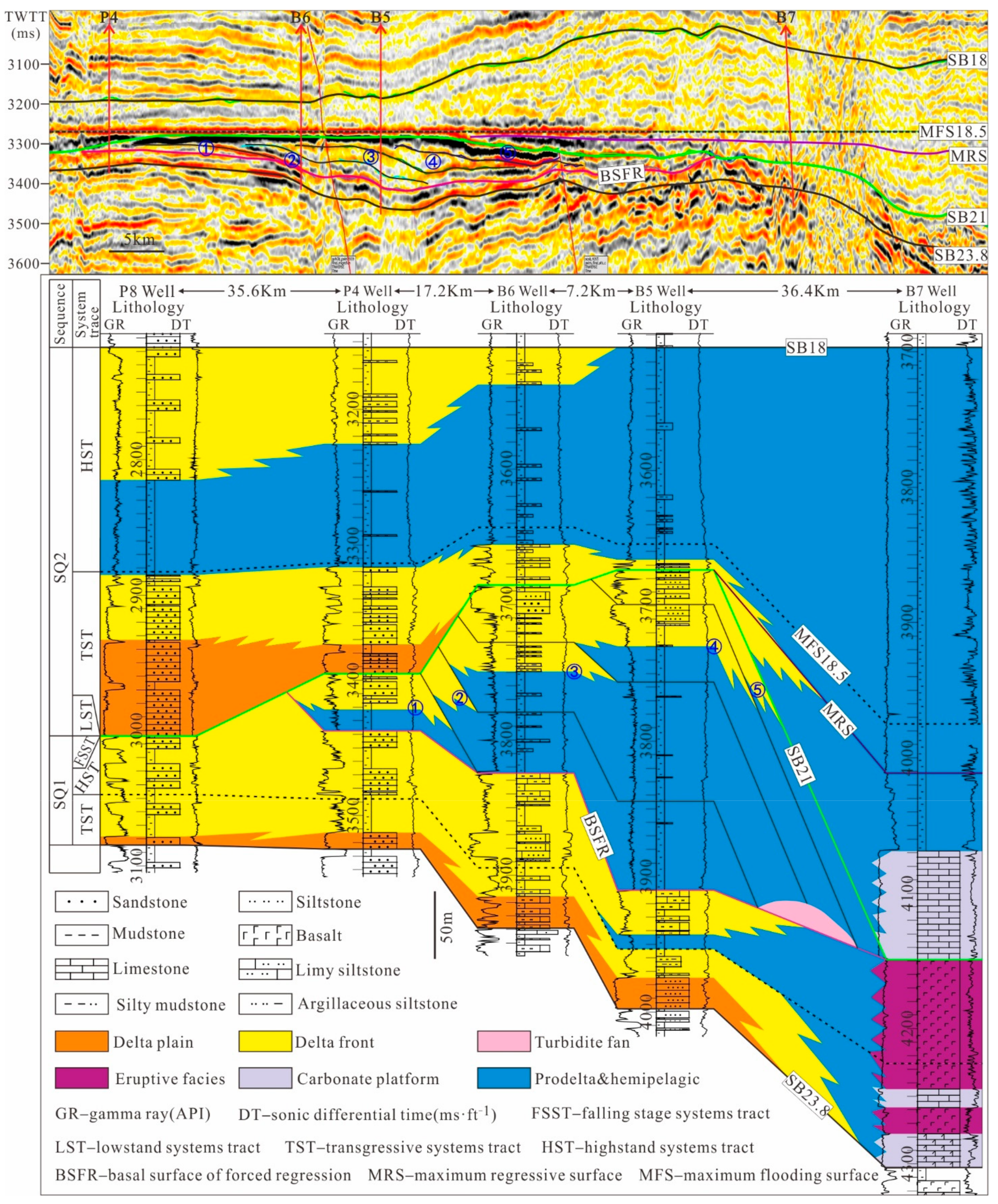
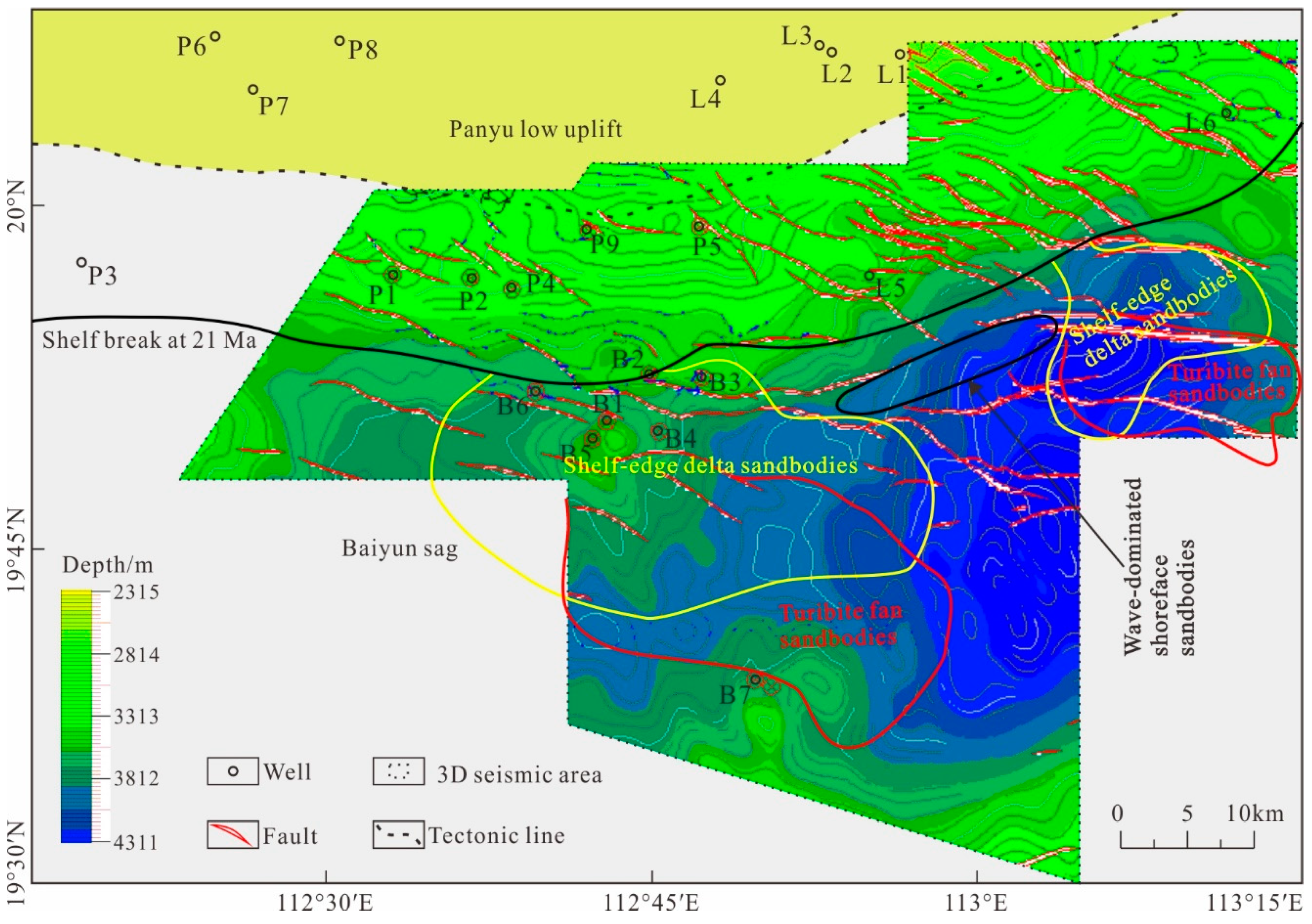
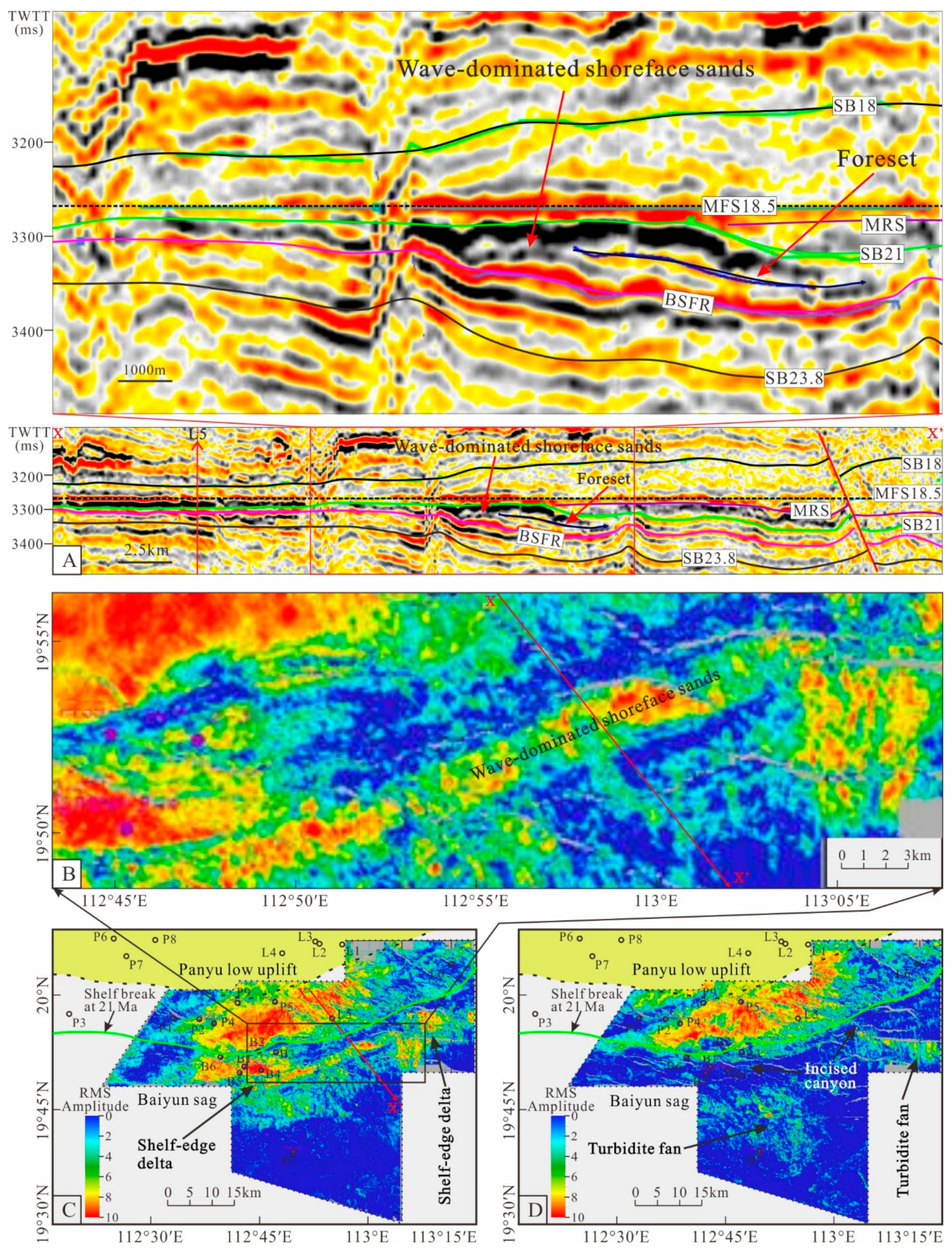
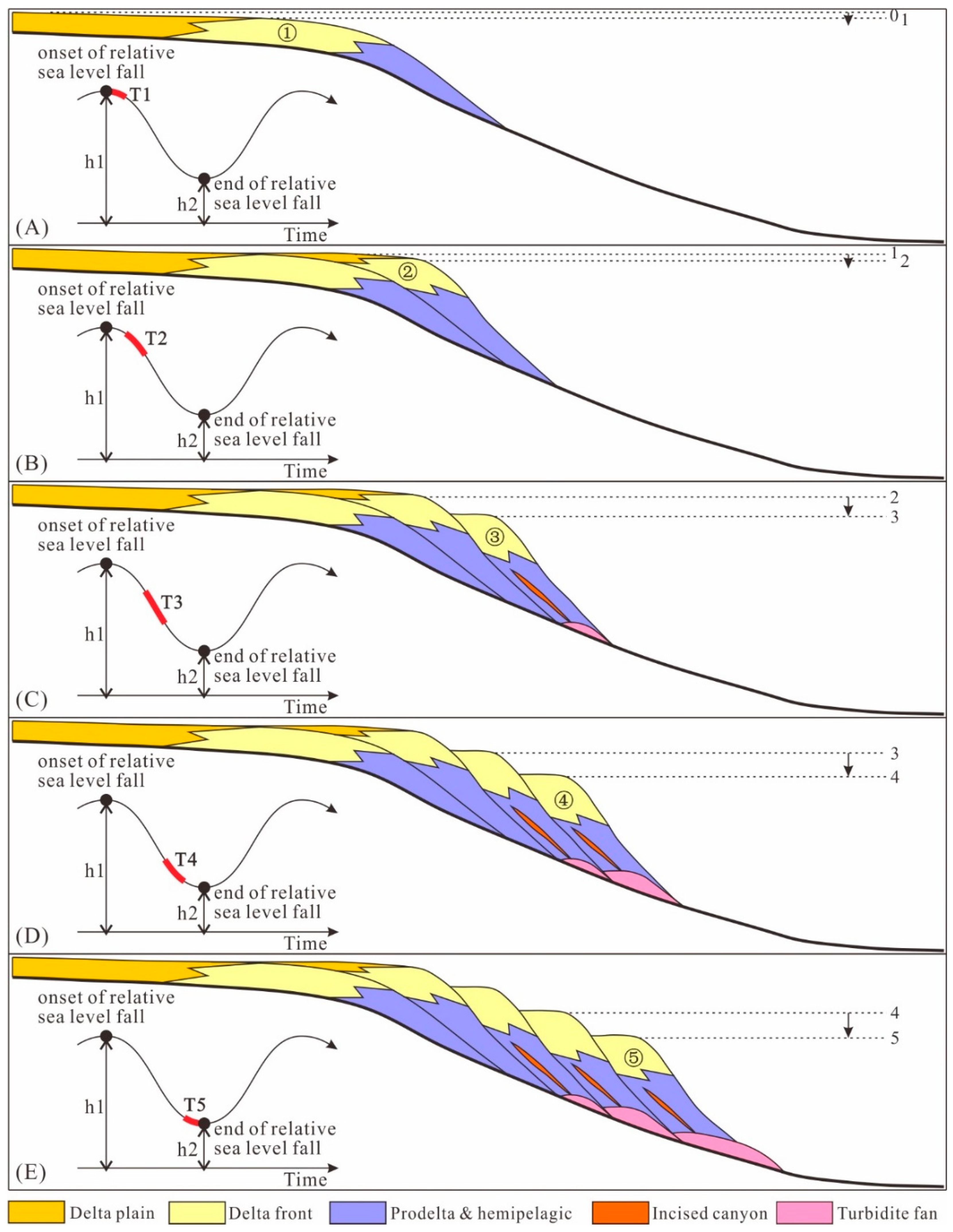
The falling stage systems tract are comparatively thick in the western part of the study area which is a shelf-edge delta, and, here, the main estuaries are abundant. There is a transition from the western part to the eastern part of the study area which are strip-shaped, wave-dominated shoreface sands; here, a small shelf-edge delta and the sub-estuary are plentiful. The falling stage systems tract was formed during the descent phase of relative sea-level. Five sets of foreset beds controlled by high-frequency relative sea-level cycles were developed, therefore ordinal regressive overlap can be observed for the five sets of shelf-edge deltas in the direction of the sea.
(5)
The favourable reservoirs which are located close to the upper boundary of the falling stage systems tract and the basal surface of forced regression are sandbodies of the shelf-edge delta front and wave-dominated shoreface sands and the sandbodies of the turbidite fan. Those sandbodies are favourable places for the formation of lithologic oil–gas reservoirs by means of good trap sealing conditions, excellent oil–gas reserving performance, and effective oil source communication of fracture system.

Author Contributions

Conceptualization, Y.Y. and C.Z.; methodology, R.Z.; formal analysis, Y.H.; investigation, Y.Y.; writing—original draft preparation, Y.Y. and L.C.; writing—review and editing, L.W.; supervision, T.C.; project administration, C.Z.; funding acquisition, Y.Y. and C.Z. All authors have read and agreed to the published version of the manuscript.

Funding

This research was funded by the National Science and Technology Major Project of China, grant number 2011ZX05023-002-007, the Hunan Provincial Natural Science Foundation of China, grant number 2019JJ50151, and the Scientific Research Fund of Hunan Provincial Education Department, grant number 18C0347.

Institutional Review Board Statement

Not applicable.

Informed Consent Statement

Not applicable.

Data Availability Statement

The data presented in this study are available on request from the corresponding author.

Acknowledgments

We gratefully thank Shenzhen branch of the China National Offshore Oil Corporation for providing the subsurface data of this study.

Conflicts of Interest

The authors declare no conflict of interest. The funders had no role in the design of the study; in the collection, analyses, or interpretation of data; in the writing of the manuscript, or in the decision to publish the results.

References

  1. Miall, A.D. Whither stratigraphy? Sediment. Geol. 1995, 100, 5–20. [Google Scholar] [CrossRef]
  2. Posamentier, H.W.; Allen, G.P.; James, D.P.; Tesson, M. Forced regressions in a sequence stratigraphic framework: Concepts, examples, and exploration significance. Am. Assoc. Pet. Geol. Bull. 1992, 76, 1687–1709. [Google Scholar]
  3. Hunt, D.; Tucker, M.E. Stranded parasequences and the forced regressive wedge systems tract: Deposition during base-level fall-reply. Sediment. Geol. 1995, 95, 147–160. [Google Scholar] [CrossRef]
  4. Plint, A.G.; Nummedal, D. The falling stage systems tract: Recognition and importance in sequence-stratigraphic analysis. In Sedimentary Responses to Forced Regressions; Geological Society of London Special Publication; Hunt, D., Gawthorpe, R.L., Eds.; Geological Society of London: London, UK, 2000; Volume 172, pp. 1–17. [Google Scholar]
  5. Catuneanu, O. Sequence stratigraphy of clastic systems: Concepts, merits, and pitfalls. J. Afr. Earth Sci. 2002, 35, 1–43. [Google Scholar] [CrossRef]
  6. Catuneanu, O. Principles of Sequence Stratigraphy; Elsevier: Amsterdam, The Netherlands, 2006; pp. 1–343. [Google Scholar]
  7. Catuneanu, O.; Zecchin, M. High-resolution sequence stratigraphy of clastic shelves II: Controls on sequence development. Mar. Pet. Geol. 2013, 39, 26–38. [Google Scholar] [CrossRef]
  8. Catuneanu, O. Model-independent sequence stratigraphy. Earth-Sci. Rev. 2019, 188, 312–388. [Google Scholar] [CrossRef]
  9. Zecchin, M.; Caffau, M.; Tosi, L.; Civile, D.; Brancolini, G.; Rizzetto, F.; Roda, C. The impact of Late Quaternary glacio-eustasy and tectonics on sequence development: Evidence from both uplifting and subsiding settings in Italy. Terra Nova 2010, 22, 324–329. [Google Scholar] [CrossRef]
  10. Zecchin, M.; Catuneanu, O.; Rebesco, M. High-resolution sequence stratigraphy of clastic shelves IV: High-latitude settings. Mar. Pet. Geol. 2015, 68, 427–437. [Google Scholar] [CrossRef]
  11. Maravelis, A.G.; Catuneanu, O.; Nordsvan, A.; Landenberger, B.; Zelilidis, A. Interplay of tectonism and eustasy during the Early Permian icehouse: Southern Sydney Basin, southeast Australia. Geol. J. 2018, 53, 1372–1403. [Google Scholar] [CrossRef]
  12. Wu, J.F.; Xu, Q.; Zhu, Y.H. Generation and evolution of the shelf-edge delta in Oligocene and Miocene of Baiyun Sag in the South China Sea. Earth Sci. J. China Univ. Geosci. 2010, 35, 681–690, (In Chinese with English abstract). [Google Scholar]
  13. Xu, Q.; Wang, Y.M.; Lv, M.; Wang, D.; Li, D.; Wang, Y.F. Identification of the shelf margin delta in sequence stratigraphic frameworks and its significance: A case study of the Baiyun Sag, South China Sea. Oil Gas Geol. 2011, 32, 733–742, (In Chinese with English abstract). [Google Scholar]
  14. Zhu, Y.H.; Zhu, W.L.; Xu, Q.; Wu, J.F. Sedimentary response to shelf-edge delta and slope deep-water fan in 13.8 Ma of Miocene epoch in Pearl River Mouth Basin. J. Cent. South Univ. (Sci. Technol.) 2011, 42, 3827–3834, (In Chinese with English abstract). [Google Scholar]
  15. Qin, C.G.; Shi, H.S.; Zhang, Z.T.; Gao, P.; Xu, H.; Qu, L.; Liu, D.L. Sedimentary characteristics and hydrocarbon exploration potential along the SQ21.0 sequence shelf-break zone on Panyu low-uplift and the north slop of Baiyun sag, Pearl River Mouth Basin. China Offshore Oil Gas 2011, 23, 14–18, (In Chinese with English abstract). [Google Scholar]
  16. Liu, B.J.; Pang, X.; Yan, C.Z.; Liu, J.; Lian, S.Y.; He, M.; Shen, J. Evolution of the Oligocene-Miocene shelf slope-break zone in the Baiyun deep-water area of the Pearl River Mouth Basin and its significance in oil-gas exploration. Acta Pet. Sin. 2011, 32, 234–242, (In Chinese with English abstract). [Google Scholar]
  17. Yi, X.F.; Zhang, C.M.; Li, S.H.; Du, J.Y. Identification marks and depositional models of the shelf-margin delta from NSQ2 of the Pearl River Mouth Basin, China. J. Chengdu Univ. Technol. (Sci. Technol. Ed.) 2012, 39, 257–261, (In Chinese with English abstract). [Google Scholar]
  18. Yi, X.F.; Zhang, C.M.; Li, S.H.; Du, J.Y.; Luo, M.; Li, X.Y. Comparison between shelf-margin delta of 21 Ma and 13.8 Ma in Pearl River Mouth Basin. Oil Gas Geol. 2014, 35, 670–678, (In Chinese with English abstract). [Google Scholar]
  19. Xu, S.H.; Wang, Y.M.; He, M.; Du, J.Y.; Chen, W.T.; Qin, C.Y.; Wang, L.L. Recognition criteria and genesis of falling stage systems tract. J. Cent. South Univ. (Sci. Technol.) 2016, 47, 531–540, (In Chinese with English abstract). [Google Scholar]
  20. Chen, W.T.; Shi, H.S.; Du, J.Y.; He, M. Formation conditions and development model of stratigraphic-lithologic traps in shelf break zone, Pearl River Mouth Basin: Zhujiang Formation as an example. Pet. Geol. Exp. 2016, 38, 619–627, (In Chinese with English abstract). [Google Scholar]
  21. Yu, Y.; Zhang, C.M.; Zhu, R.; Du, J.Y.; Huang, Y.R.; Wang, L. Recognition characteristics and hydrocarbon significance of falling stage systems tract. Acta Sedimentol. Sin. 2019, 37, 345–355, (In Chinese with English abstract). [Google Scholar]
  22. Hao, F.; Sun, Y.C.; Li, S.T.; Zhang, Q.M. Overpressure retardation of organic-matter maturation and petroleum generation-A case study from the Yinggehai and Qiongdongnan Basins, South China Sea. AAPG Bull. 1995, 79, 551–562. [Google Scholar]
  23. Hao, F.; Li, S.T.; Gong, Z.S.; Yang, J.M. Thermal regime, inter-reservoir compositional heterogeneities, and reservoir-filling history of the Dongfang Gas Field, Yinggehai Basin, South China Sea: Evidence for episodic fluid injections in overpressured basins? AAPG Bull. 2000, 84, 607–626. [Google Scholar]
  24. Zhou, D.; Yao, B.C. Tectonics and Sedimentary Basins of the South China Sea: Challenges and Progresses. J. Earth Sci. 2009, 20, 1–12. [Google Scholar] [CrossRef]
  25. Wang, Y.F.; Wang, Y.M.; Xu, Q.; Li, D.; Zhuo, H.T.; Zhou, W. The early-middle Miocene submarine fan system in the Pearl River Mouth Basin, South China Sea. Pet. Sci. 2012, 9, 1–9. [Google Scholar] [CrossRef] [Green Version]
  26. Chen, S.Z.; Pei, C.M. Geology and geochemistry of source rocks of the Eastern Pearl River Mouth Basin, South China Sea. J. Southeast Asian Earth Sci. 1993, 81, 393–406. [Google Scholar]
  27. Zhang, C.G.; Yang, H.C.; Chen, Y.; Ji, M.; Wang, K.; Yang, D.S.; Han, Y.X.; Sun, Y.H. The Baiyun sag: A giant rich gas-generation sag in the deepwater area of the Pearl River Mouth Basin. Nat. Gas Ind. 2014, 34, 11–25, (In Chinese with English abstract). [Google Scholar]
  28. Ma, B.J.; Wu, S.G.; Sun, Q.L.; Mi, L.J.; Wang, Z.Z.; Tian, J. The late Cenozoic deep-water channel system in the Baiyun sag, Pearl River Mouth Basin: Development and tectonic effects. Deep-Sea Res. Part II 2015, 122, 226–239. [Google Scholar] [CrossRef]
  29. Yu, Y.; Zhang, C.M.; Wang, L.; Li, S.H.; Hursthouse, A.; Huang, Y.R.; Cao, T.T. Sedimentary characteristics and genetic mechanism of a deep-water channel system in the Zhujiang Formation of Baiyun Sag, Pearl River Mouth Basin. Deep-Sea Res. Part I Oceanogr. Res. Pap. 2021, 168, 1–19. [Google Scholar] [CrossRef]
  30. Huang, C.J.; Zhou, D.; Sun, Z.; Chen, C.M.; Hao, H.J. Deep crustal structure of Baiyun Sag, Northern South China Sea revealed from deep seismic reflection profile. Chin. Sci. Bull. 2005, 50, 1131–1138. [Google Scholar] [CrossRef]
  31. Sun, Z.; Pang, X.; Zhong, Z.H.; Zhou, D.; Chen, C.M.; Hao, H.J.; He, M.; Huang, C.J. Dynamics of Tertiary tectonic evolution of the Baiyun Sag in the Pearl River Mouth Basin. Earth Sci. Front. 2005, 12, 489–498, (In Chinese with English abstract). [Google Scholar]
  32. Sun, Z.; Zhong, Z.H.; Keep, M.; Zhou, D.; Cai, D.S.; Li, X.S.; Wu, S.M.; Jiang, J.Q. 3D analogue modeling of the South China Sea: A discussion on Breakup pattern. J. Asian Earth Sci. 2009, 34, 544–556. [Google Scholar] [CrossRef]
  33. Pang, X.; Chen, C.M.; Peng, D.J.; Zhou, D.; Shao, L.; He, M.; Liu, B.J. Basic geology of Baiyun deep-water area in the Northern South China Sea. China Offshore Oil Gas 2008, 20, 215–222, (In Chinese with English abstract). [Google Scholar]
  34. Zhou, W.; Gao, X.Z.; Wang, Y.M.; Zhuo, H.T.; Zhu, W.L.; Xu, Q.; Wang, Y.F. Seismic geomorphology and lithology of the early Miocene Pearl River Deepwater fan system in the Pearl River Mouth Basin, Northern South China Sea. Mar. Pet. Geol. 2015, 68, 449–469. [Google Scholar] [CrossRef]
  35. Huang, C.Y.; Xia, K.Y.; Yuan, P.B.; Chen, P.G. Structural evolution from Paleocene extension to latest Miocene-Recent arc-continent collision offshore Taiwan: Comparison with on land geology. J. Asian Earth Sci. 2001, 19, 619–639. [Google Scholar] [CrossRef]
  36. Zhou, W.; Wang, Y.M.; Gao, X.Z.; Zhu, W.L.; Xu, Q.; Xu, S.; Cao, J.Z.; Wu, J. Architecture, evolution history and controlling factors of the Baiyun submarine canyon system from the middle Miocene to Quaternary in the Pearl River Mouth Basin, northern South China Sea. Mar. Pet. Geol. 2015, 67, 389–407. [Google Scholar] [CrossRef]
  37. Lüdmann, L.; Wong, H.K.; Wang, P.X. Plio-Quaternary sedimentation processes and neotectonics of the northern continental margin of the South China Sea. Mar. Geol. 2001, 172, 331–358. [Google Scholar] [CrossRef]
  38. Pang, X.; Chen, C.M.; Peng, D.J.; Zhu, M.; Shu, Y.; He, M.; Shen, J.; Liu, B.J. Sequence stratigraphy of deep-water fan system of Pearl River, South China Sea. Earth Sci. Front. 2007, 14, 220–229, (In Chinese with English abstract). [Google Scholar] [CrossRef]
  39. Zhu, W.; Huang, B.; Mi, L.; Wilkins, R.W.T.; Fu, N.; Xiao, X. Geochemistry, origin, and deep-water exploration potential of natural gases in the Pearl River Mouth and Qiongdongnan Basins, South China Sea. AAPG Bull. 2009, 93, 741–761. [Google Scholar] [CrossRef]
  40. Qin, G.Q. Late Cenozoic sequence stratigraphy and sea-level changes in Pearl River Mouth Basin, South China sea. China Offshore Oil Gas 2002, 16, 1–10, (In Chinese with English abstract). [Google Scholar]
  41. Li, X.Y.; Zhang, C.M.; Zhang, S.F.; Zhu, R.; Luo, M.; Shi, H.S.; Du, J.Y. Neogene sequence subdivision and its development pattern in Pearl River Mouth Basin. J. Oil Gas Technol. 2012, 34, 47–52, (In Chinese with English abstract). [Google Scholar]
  42. Zhu, R.; Zhang, C.M.; Du, J.Y.; Zhang, S.F.; Li, X.Y. Controls of Neogene sea level change on sand bodies in the Pearl River Mouth Basin. Geol. J. China Univ. 2015, 21, 685–693, (In Chinese with English abstract). [Google Scholar]
  43. Haq, B.U.; Hardenbol, J.; Vail, P.R. Mesozoic and Cenozoic chronostratigraphy and cycles of sea-level change. In Sea Level Changes–An Integrated Approach, SEPM Special Publication; Wilgus, C.K., Hastings, B.S., Kendall, C.G., Posamentier, H.W., Ross, C.A., Van Wagoner, J.C., Eds.; SEPM Society for Sedimentary Geology: Broken Arrow, OK, USA, 1988; Volume 42, pp. 71–108. [Google Scholar]
  44. Pang, X.; Chen, C.M.; Shao, L.; Wang, C.S.; Zhu, M. Baiyun Movement, a Great Tectonic Event on the Oligocene-Miocene Boundary in the Northern South China Sea and Its Implications. Geol. Rev. 2007, 53, 145–150, (In Chinese with English abstract). [Google Scholar]
  45. Liu, H.; Wang, Y.M.; Wang, Y. Depositional slope break in shallow marine shelf setting and its control on regional forced regressive wedge systems tract. Acta Sedimentol. Sin. 2011, 29, 906–916, (In Chinese with English abstract). [Google Scholar]
Figure 1. (A) Location map showing the tectonic compartmentalisation of the Pearl River Mouth Basin in the Northern South China Sea. (B) Location distribution of research data. The study area located in the Panyu low uplift and Baiyun sag. Note the forced regressive deposits mainly developed in the northern Baiyun sag.
Jmse 09 01298 g001
Figure 2. Stratigraphic Sequence framework for the Pearl River Mouth Basin. The red solid line shows approximated locations of shelf breaks. Colours of the lithology column: brown = basement rock; blue = erosion; yellow = sandstone; grey = mudstone; green = carbonate; black = coal deposits; violet = magmatic intrusive rock.
Jmse 09 01298 g002
Figure 3. Lithologic characteristics and sedimentary structures in the Zhujiang Formation of Pearl River Mouth Basin, northern South China Sea: (A) The core shows grey medium-coarse sandstone with tabular cross bedding in well P6 (2771.4 m). (B) The core shows red-brown gravelly medium-coarse sandstone with massive bedding in well P1 (3349.3 m). (C) The core shows red-brown mudstone with iron nodules and horizontal bedding in well P1 (3345 m). (D) The core shows grey silt-stone-fine sandstone with small cross bedding in well P2 (3304.4 m). (E) The core shows gray siltstone-fine sandstone with reverse grain sequence characteristics, biological disturbance, and horizontal wormholes in well P2 (3305.5 m). (F) The core shows red-brown fine sandstone with parallel bedding in well B4 (3741 m). (G) The core shows yellow-gray fine sandstone with wedge cross bedding in well B4 (3755 m). (H) The core shows yellow-gray fine sandstone with shaly strip deformation structure in well B4 (3732.1 m).
Jmse 09 01298 g003
Figure 4. Sedimentary facies and sequence stratigraphy characteristic of single well in Zhujiang Formation of Panyu low uplift and Baiyun sag, Pearl River Mouth Basin. Note that Well P1 is above the shelf break at 21 Ma and landward, the Well B5 is below the shelf break at 21 Ma and seaward.
Jmse 09 01298 g004
Figure 5. Seismic profile corresponding to sequence and sedimentary system of the Panyu low uplift and Baiyun sag in Pearl River Mouth Basin (location of section is given in Figure 1B): (A) Seismic facies characteristics with oblique progradational configuration in the depositional trends. (B) Seismic facies characteristics with divergent fill in the vertical depositional trends. Note the seismic profile is below the shelf break at 21 Ma and seaward.
Jmse 09 01298 g005
Figure 6. Distribution range of the shelf-edge delta (A) and the turbidite fan (B): (A) The yellow coil is the development range of the shelf-edge delta. Root mean square amplitude attribute extracted 30 ms downward from the 21 Ma, which is the upper interface of falling stage systems tract. (B) The red coil is the development range of the turbidite fan. Root mean square amplitude attribute extracted 30 ms upward from the basal surface of forced regression.
Jmse 09 01298 g006
Figure 7. Correlation of wells illustrating the depositional sequences in the Zhujiang Formation of Panyu low uplift and Baiyun sag, Pearl River Mouth Basin (location of section is given in Figure 1B).
Jmse 09 01298 g007
Figure 8. Correlation of wells illustrating the depositional sequences in the Zhujiang Formation of Panyu low uplift and Baiyun sag, Pearl River Mouth Basin (location of section is given in Figure 1B).
Jmse 09 01298 g008
Figure 9. (A) Seismic reflection features of falling stage systems tract in the depositional trends (location of section is given in Figure 1B and Figure 9C). (B) Local amplification of root mean square amplitude attribute (location of section is given in Figure 9B). (C) Root mean square amplitude attribute extracted 30 ms downward from the 21 Ma which is the upper interface of falling stage systems tract. (D) Root mean square amplitude attribute extracted 30 ms upward from the basal surface of forced regression.
Jmse 09 01298 g009
Figure 10. Depositional features and shoreline migration trajectory of falling stage systems tract: (A) Sedimentary sequence characteristics of single well. (B) Seismic reflection features of falling stage systems tract in the depositional trends (location of section is given in Figure 1B). (C) Seismic profile interpretation results of falling stage systems tract and reconstruction of shoreline migration trajectory.
Jmse 09 01298 g010
Figure 11. Sedimentary evolution model of forced regression in the Zhujiang Formation of the Pearl River Mouth Basin, northern South China Sea. (A) The sea level dropped from position 0 to position 1. The foreset ① was deposited in T1 stage. The shelf-edge delta with delta plain, delta front, and prodelta was developed. (B) The sea level dropped from position 1 to position 2. The foreset ② was deposited in T2 stage. The characteristics of shelf-edge delta are similar to those of the previous period. (C) The sea level dropped from position 2 to position 3. The foreset ③ was deposited in T3 stage. Only the delta front and the prodelta were developed in the shelf-edge delta. Deep-water channel and turbidite fan are developed. (D) The sea level dropped from position 3 to position 4. The foreset ④ was deposited in T4 stage. The sedimentary characteristics of this stage are similar to those of the previous stage. (E) The sea level dropped from position 4 to position 5. The foreset ⑤ was deposited in T5 stage. The turbidite fan developed greatly at this stage.
Jmse 09 01298 g011
Figure 12. Relationship between sandbodies of falling stage systems tract and structural configurations. The structural contour is the depth of maximum flooding surface in the sequence SQ2. The area defined by the yellow coil is the development range of the shelf-edge delta which is determined on the basis of Figure 6A. The area defined by the black coil is the development range of the wave-dominated shoreface sands which is determined on the basis of Figure 9B. The area defined by the red coil is the development range of the turbidite fan which is determined on the basis of Figure 6B.
Jmse 09 01298 g012
Publisher’s Note: MDPI stays neutral with regard to jurisdictional claims in published maps and institutional affiliations.

