Estimation of Background Erosion Rate at Janghang Beach due to the Construction of Geum Estuary Tidal Barrier in Korea

Abstract
1. Introduction
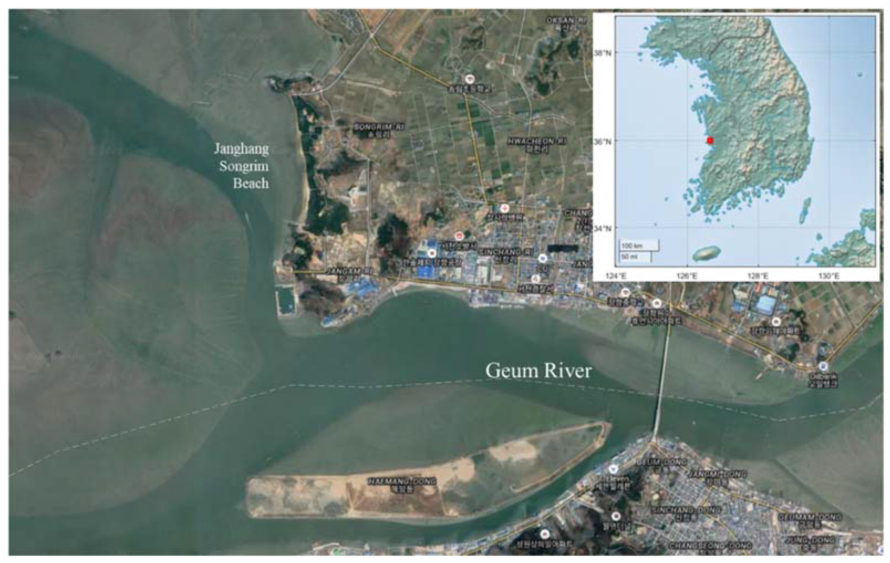
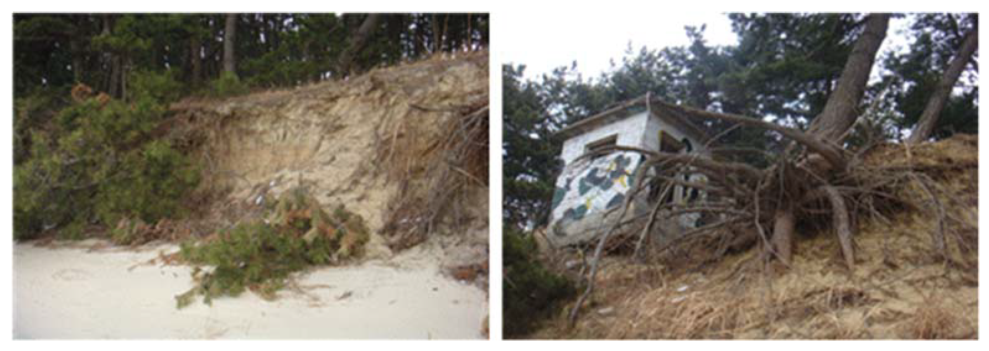
2. Site Description
3. Theoretical Background
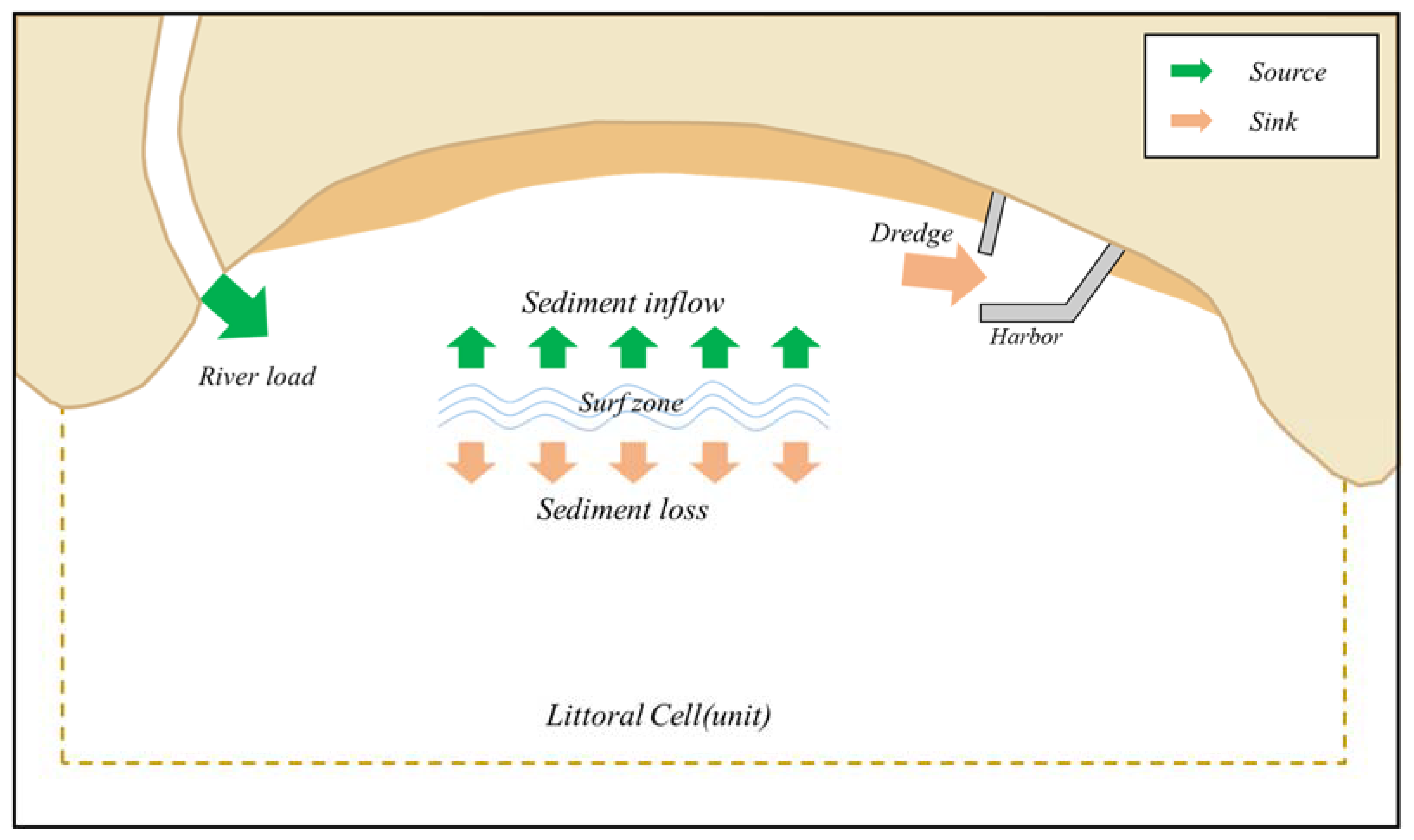
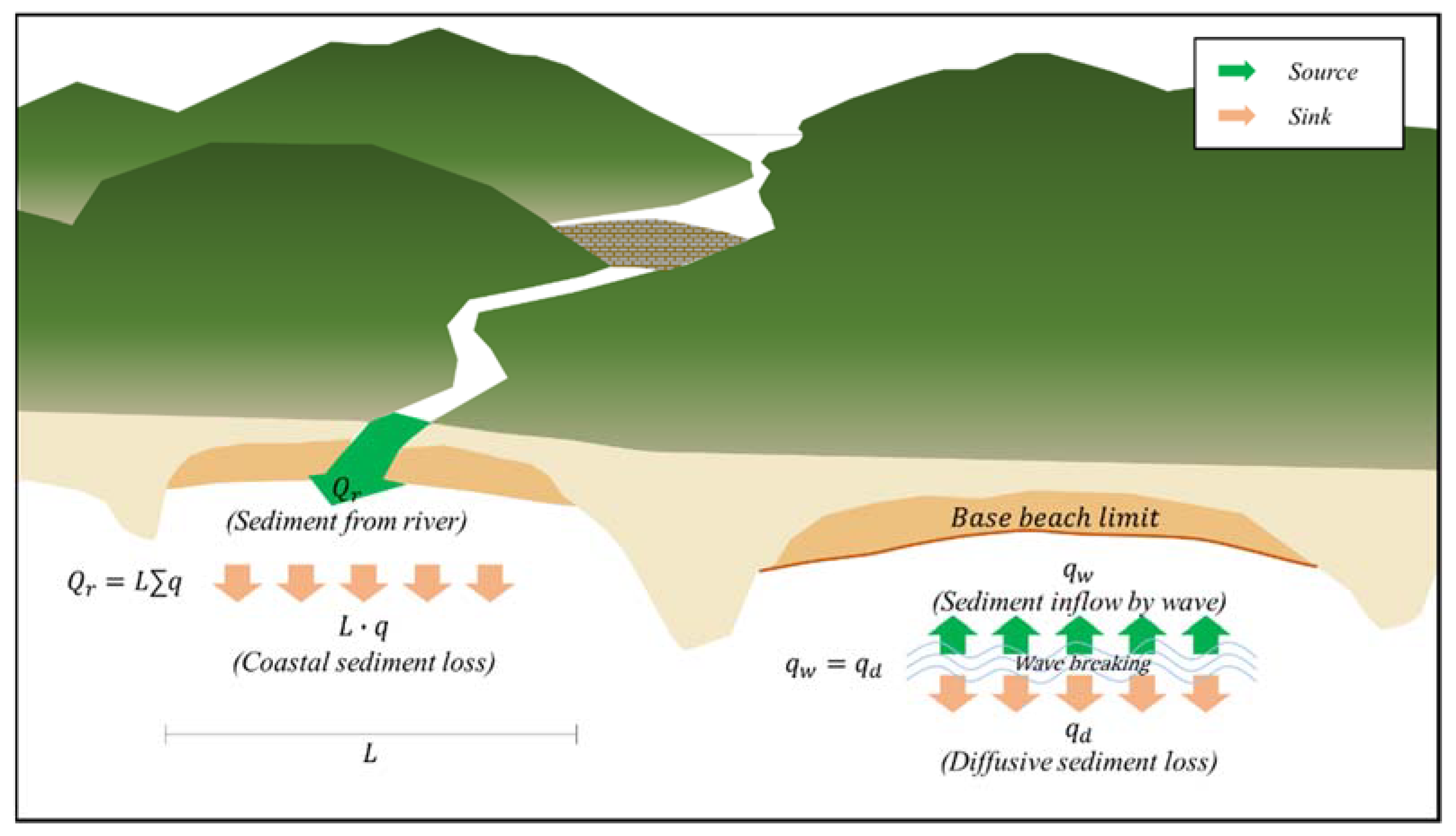
3.1. Mass Conservation in Littoral Cell
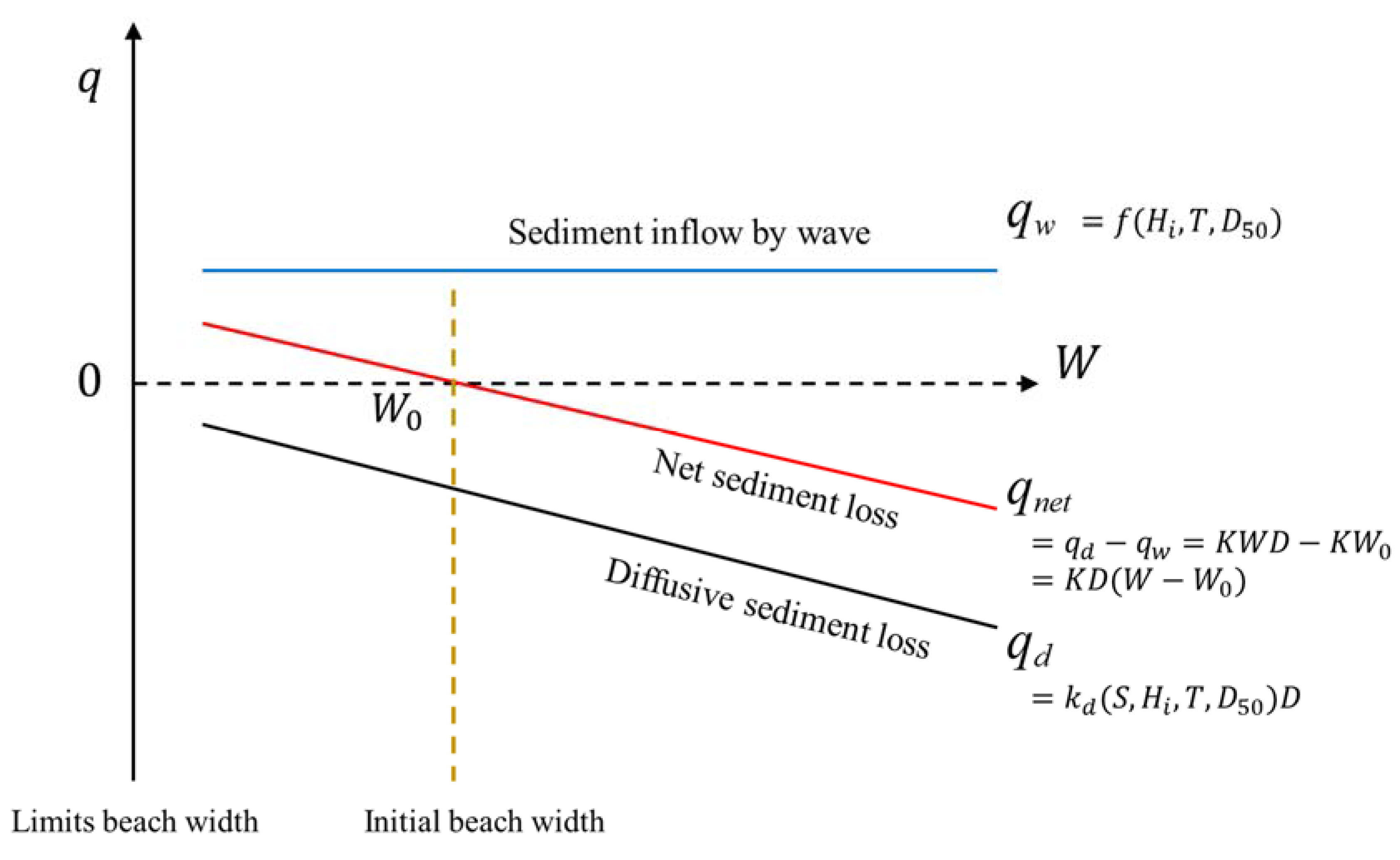
3.2. Coastal Sediment Loss Rate
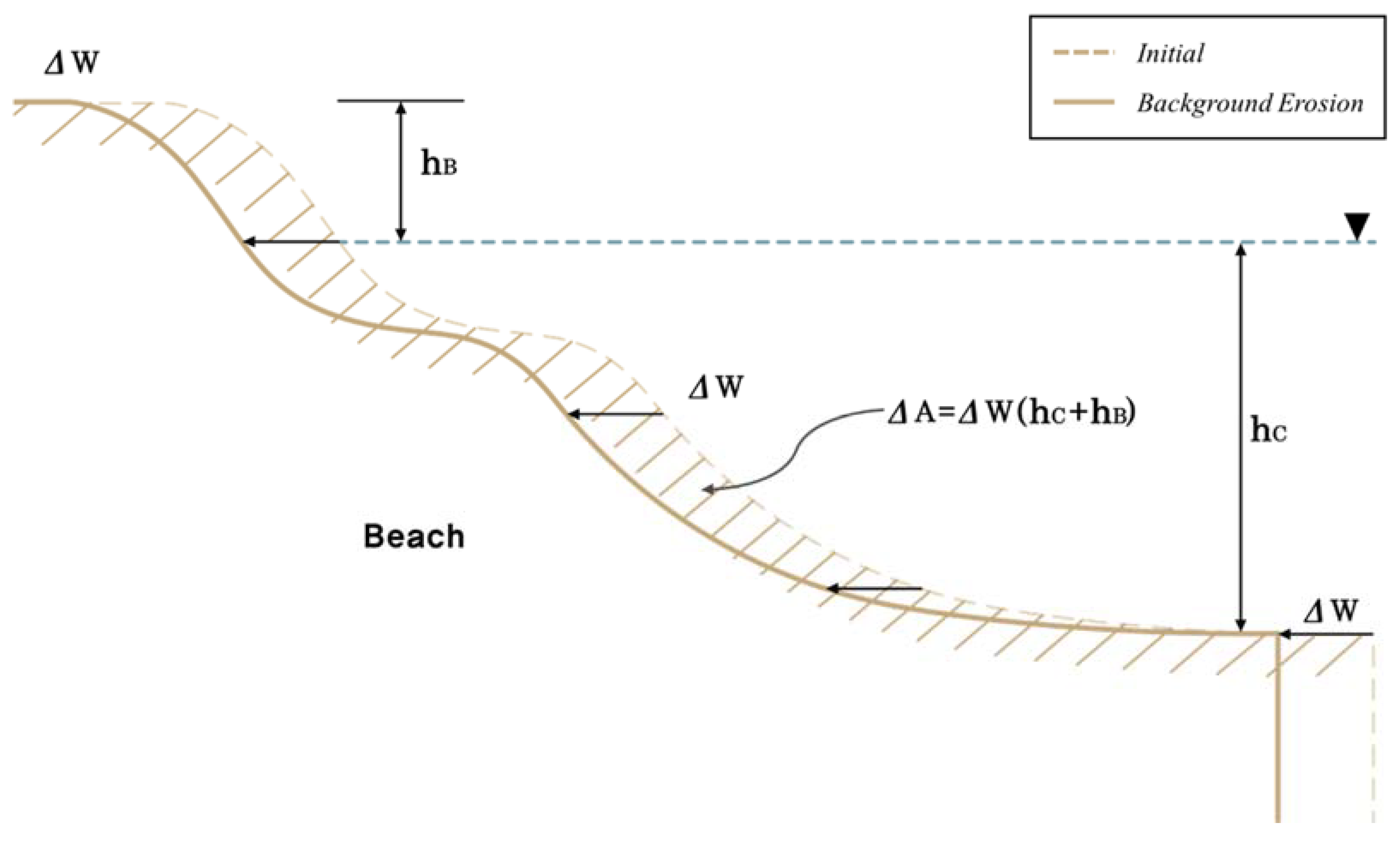
3.3. Shoreline Change from Background Erosion
4. Results
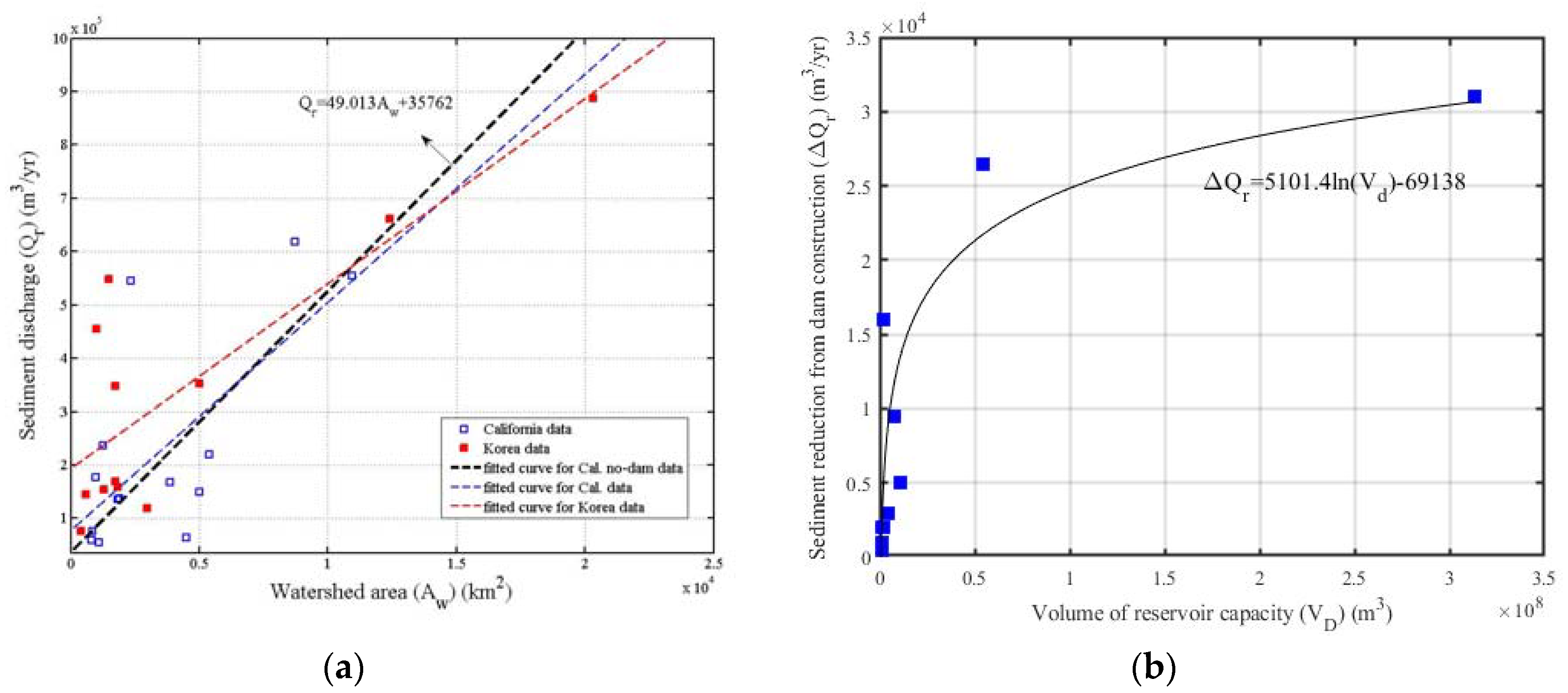
4.1. Estimation of Reduction in Sediment Volume by Dam Construction in Geum Estuary
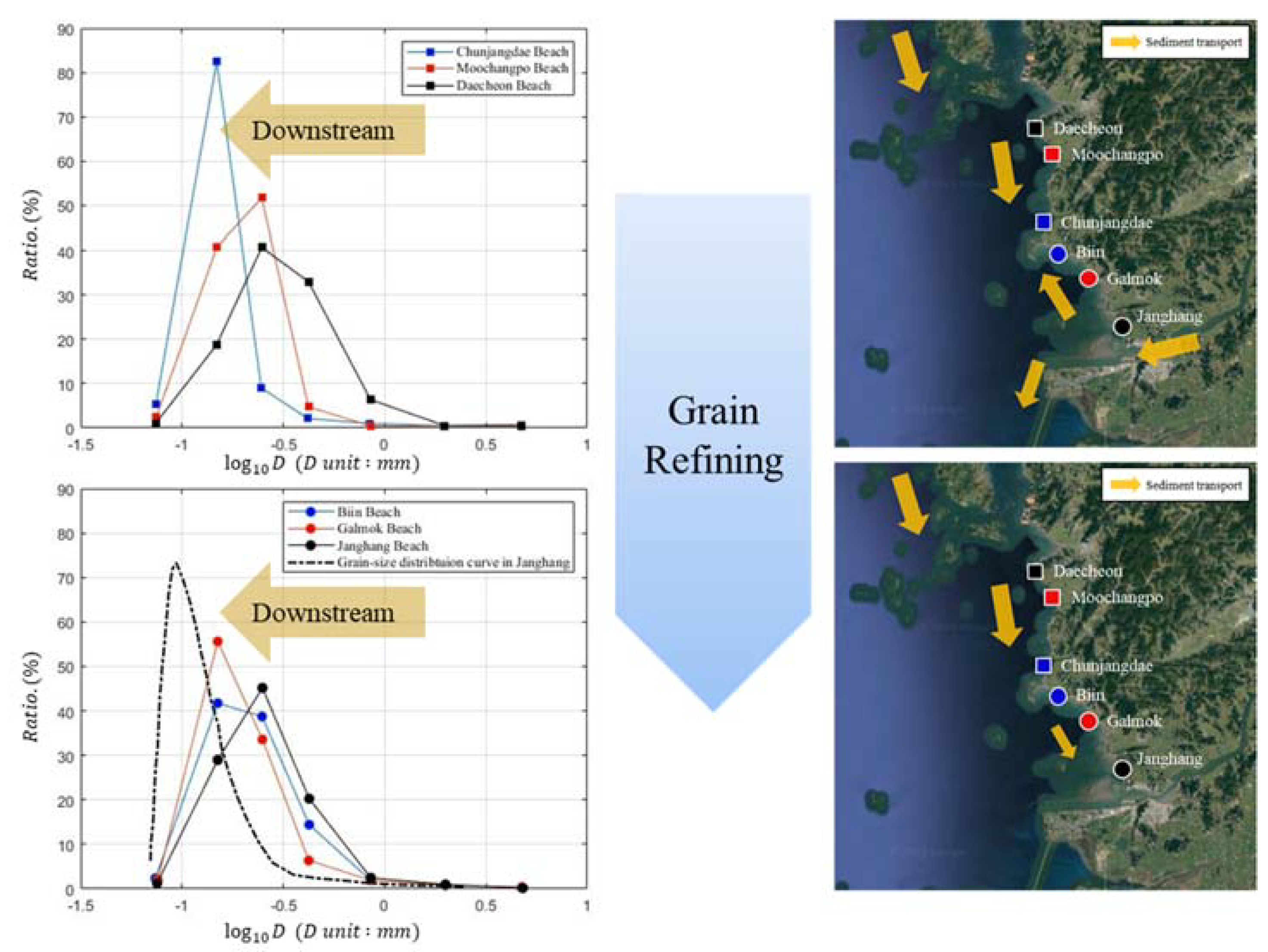
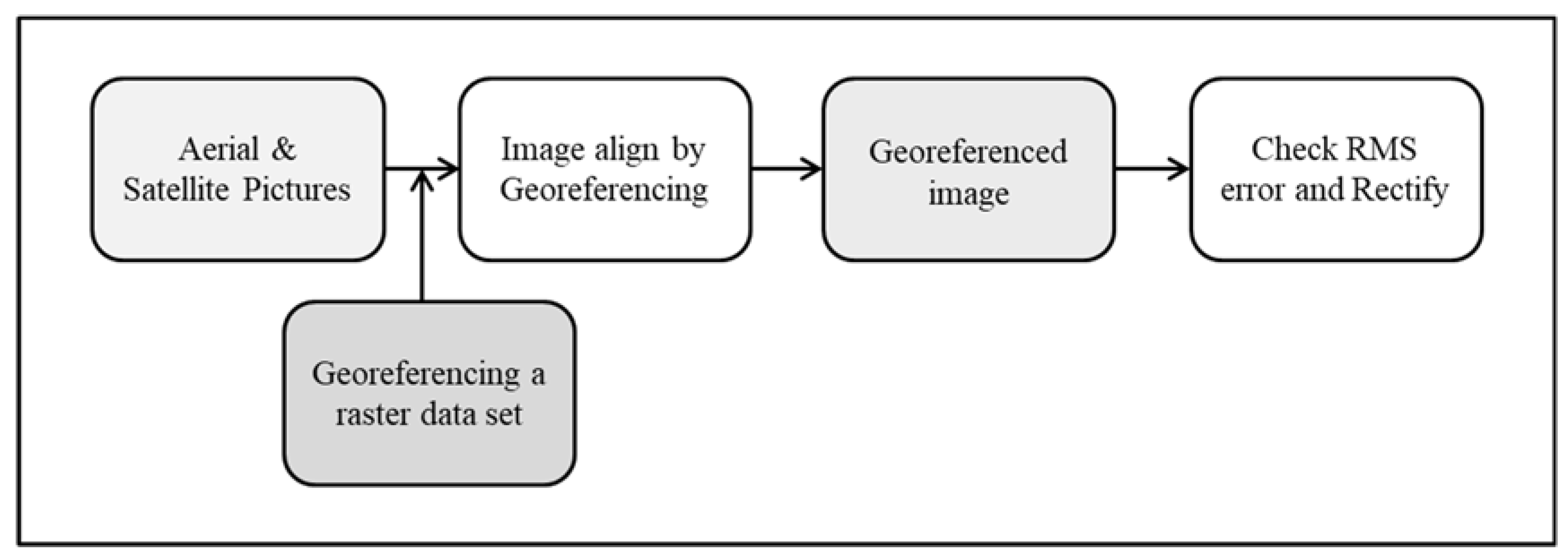
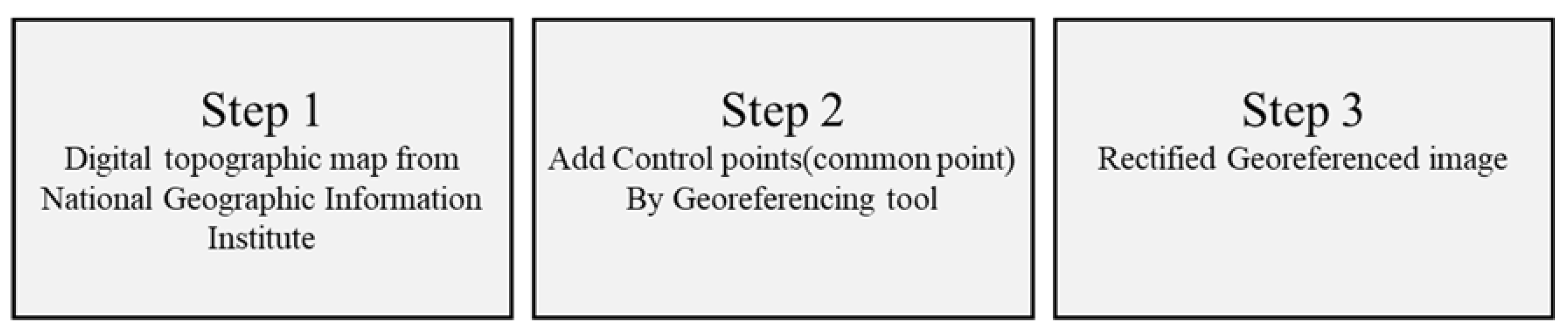
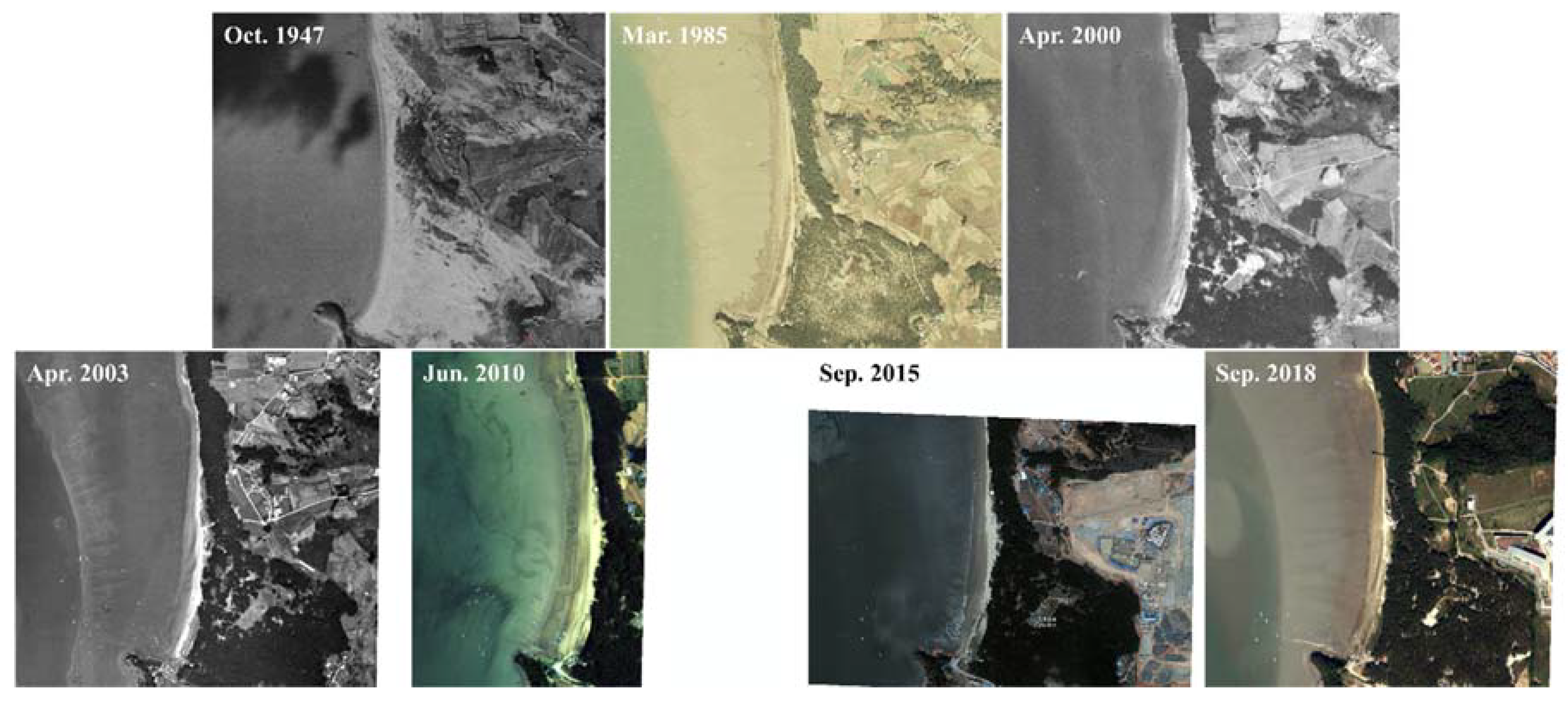
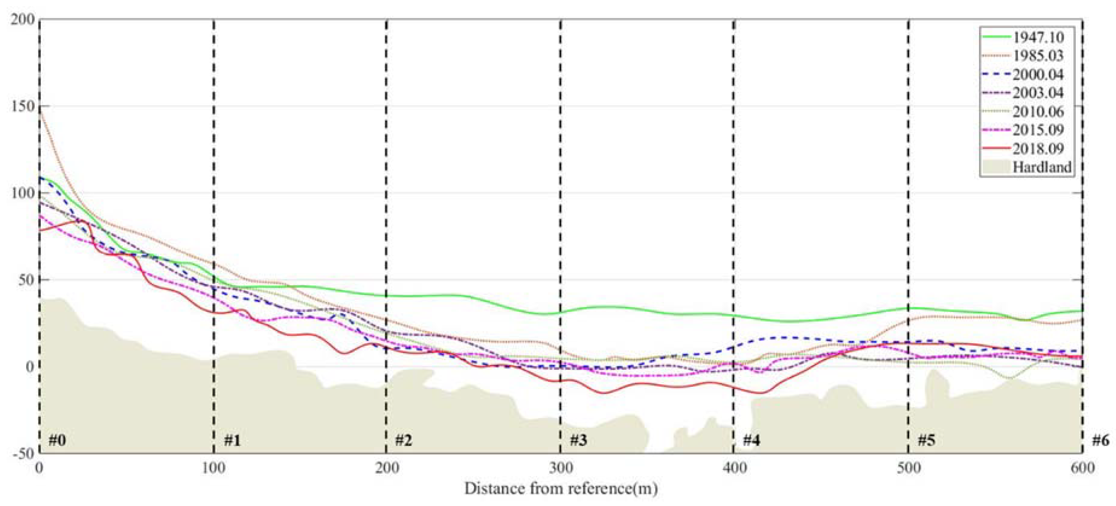
4.2. Geometric Correction of Aerial Photographs
4.3. Estimation of Coastal Sediment Loss Rate(K)
5. Discussion
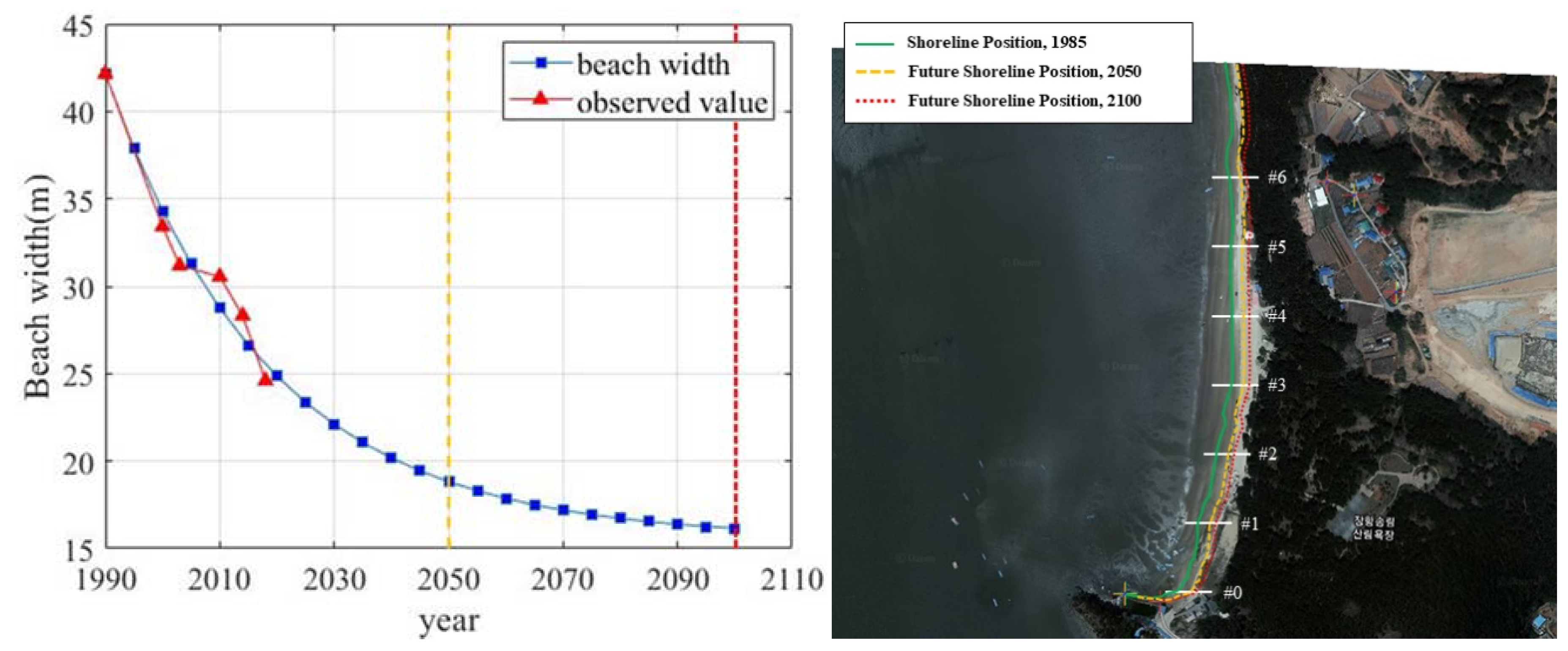
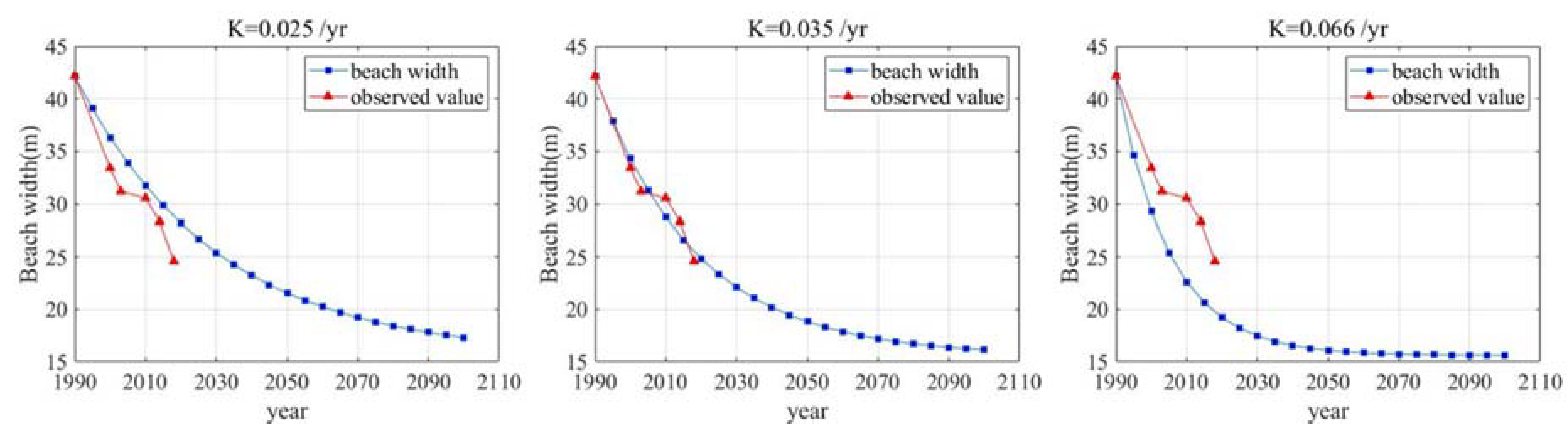
5.1. Estimation of Background Erosion Rate
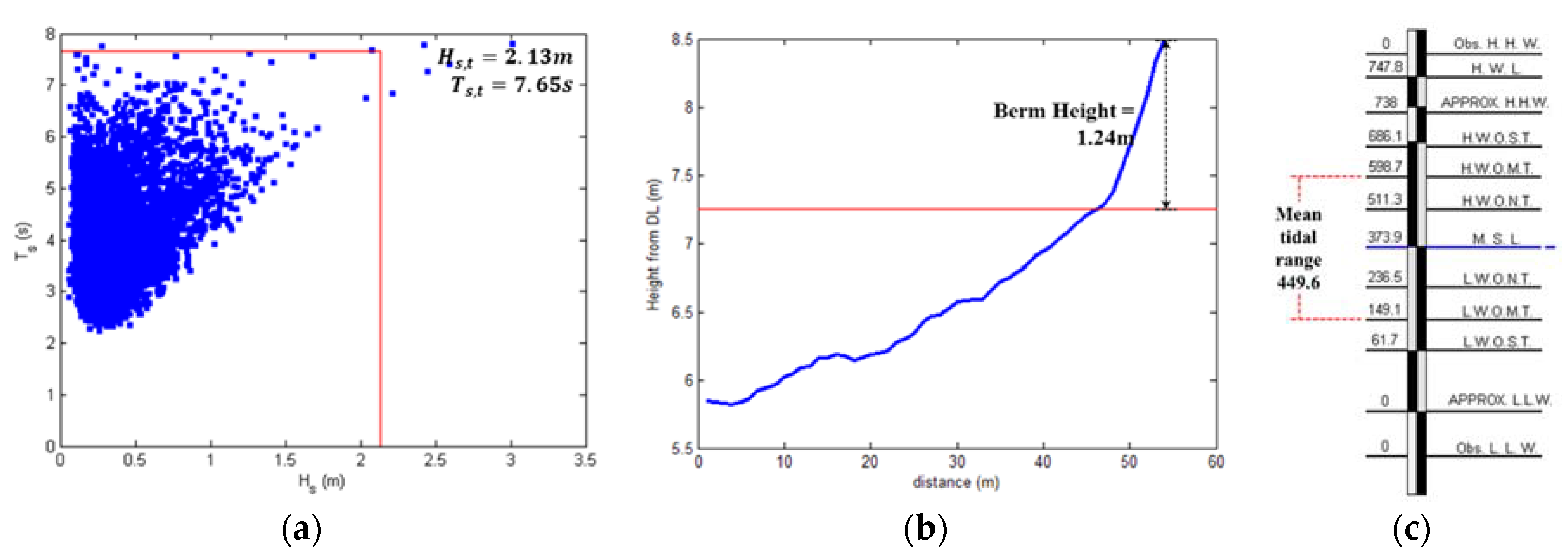
5.2. Discussion on Closure Depth in Macro-Tidal Coast
5.3. Discussion on Further Application from Study Findings
6. Conclusions
Author Contributions
Funding
Conflicts of Interest
References
- Korea Environment Institute (KEI). Study on the Effective Mitigation Measures of Coastal Erosion due to Coastal Developments, RE-21; Korea Environment Institute: Sejong-si, Republic of Korea, 2006; pp. 71–118. [Google Scholar]
- Wasyl, J.; Jenkins, S.A.; Skelly, D.W. Sediment bypassing around dams: A potential beach erosion control mechanism. In The California Coastal Aone Experience, Symposium on Coastal and Ocean Management; Domurat, G., Wakeman, T., Eds.; American Society of Civil Engineers: New York, NY, USA, 1978; pp. 251–265. [Google Scholar]
- Batalla, R.J.; Go’mez, C.M.; Kondolf, G.M. River impoundment and changes in flow regime, Ebro River basin, northeastern Spain. J. Hydrol. 2004, 290, 117–136. [Google Scholar] [CrossRef]
- Sanchez-Arcilla, A.; Jimenez, J.A.; Valdemoro, H.I. The Ebro Delta: Morphodynamics and vulnerability. J. Coast. Res. 1998, 14, 754–772. [Google Scholar]
- Willis, C.M.; Griggs, G.B. Reductions in fluvial sediment discharge by coastal dams in California and implications for beach sustainability. J. Geol. 2003, 111, 167–182. [Google Scholar] [CrossRef]
- Foley, M.M.; Jonathan, A.W.; Andrew, R.; Andrew, W.S.; Patrick, B.S.; Jeffrey, J.D.; Matthew, M.B.; Rebecca, P.; Guy, G.; Randal, M.; et al. Coastal habitat and biological community response to dam removal on the Elwha River. Ecol. Monogr. 2017, 87, 552–577. [Google Scholar] [CrossRef]
- Randle, T.J.; Bountry, J.A.; Ritchie, A.; Wille, K. Large-scale dam removal on the Elwha River, Washington, USA: Erosion of reservoir sediment. Geomorphology 2015, 246, 709–728. [Google Scholar] [CrossRef]
- Warrick, J.A.; Jennifer, A.B.; Amy, E.E.; Christopher, S.M.; Timothy, J.R.; Guy, G.; Andrew, C.R.; George, R.P.; Vivian, L.; Jeffrey, J.D. Large-scale dam removal on the Elwha River, Washington, USA: Source-to-sink sediment budget and synthesis. Geomorphology 2015, 246, 729–750. [Google Scholar] [CrossRef]
- Foley, M.M.; Warrick, J.A. Ephemeral seafloor sedimentation during dam removal: Elwha River, Washington. Cont. Shelf Res. 2017, 150, 36–47. [Google Scholar] [CrossRef]
- Warrick, J.A.; Stevens, A.W.; Miller, I.M.; Harrison, S.R.; Ritchie, A.C.; Gelfenbaum, G. World’s largest dam removal reverses coastal erosion. Sci. Rep. 2019, 9, 1–12. [Google Scholar] [CrossRef] [PubMed]
- Bruun, P. Sea-level rise as a cause of shore erosion. J. Waterw. Harb. Coast. Eng. Div. ASCE 1962, 88, 117–130. [Google Scholar]
- Zang, K. Twentieth century storm activity and sea level rise along the U.S. east coast and their impact on shoreline position. Ph.D. Thesis, University of Maryland, College Park, MD, USA, 1997. [Google Scholar]
- Cho, W.; Yoon, J.S.; Hur, D.S.; Lee, J.L. New Profile Fitting Approach for Estimating Beach Recession Resulting from Sea-Level Rise. In Proceedings of the Coastal Sediments 2015, San Diego, CA, USA, 11 May 2015; pp. 1–9. [Google Scholar]
- U.S. ARMY CORPS OF ENGINEERS. Shore of New Jersey from Sandy Hook to Barnegat Inlet, Beach Erosion Control Study; Letter from the Secretary of the Army, House Document No. 361, 84th Congress, 2nd Session; U.S. Government Printing Office: Washington, DC, USA, 1957.
- U.S. ARMY CORPS OF ENGINEERS. Shore of New Jersey from Sandy Hook to Barnegat Inlet, Beach Erosion Control Study; Letter from the Secretary of the Army, House Document No. 362, 85th Congress, 2nd Session; U.S. Government Printing Office: Washington, DC, USA, 1958.
- Caldwell, J.M. Coastal Processes and Beach Erosion. J. Soc. Civ. Eng. 1966, 53, 142–157. [Google Scholar]
- Dolan, T.J.; Castens, P.G.; Sonu, C.J.; Egense, A.K. Review of Sediment Budget Methodology: Oceanside Littoral Cell, California. In Proceedings of the Coastal Sediments ‘87 (ASCE), Reston, VA, USA, 23 May 1987; pp. 1289–1304. [Google Scholar]
- Kana, T.; Stevens, F. Coastal Geomorphology and Sand Budgets Applied to Beach Nourishment. In Proceedings of the Coastal Engineering Practice ‘92 (ASCE), Long Beach, CA, USA, 9 March 1992; pp. 29–44. [Google Scholar]
- Kraus, N.C.; Rosati, J.D. Estimation of Uncertainty in Coastal-Sediment Budgets at Inlets; Coastal Engineering Technical Note CETN IV-16; U.S. Army Engineer Research and Development Center, Coastal and Hydraulics Laboratory: Vicksburg, MS, USA, 1999.
- Kraus, N.C.; Rosati, J.D. Estimating Uncertainty in Coastal Inlet Sediment Budgets. In Proceedings of the 12th Annual National Conference on Beach Preservation Technology (Florida Shore & Beach Preservation Association), Tallahassee, FL, USA, 27 January 1999; pp. 287–302. [Google Scholar]
- Patsch, K.; Gary, G.B. Development of Sand Budgets for California’s Major Littoral Cells; Institute of Marina Sciences University of California: Santa Cruz, CA, USA, 2007. [Google Scholar]
- Environment Agency. Sediment Budget Analysis: Practitioner Guide; 2018. Available online: https://www.gov.uk/government/publications/sediment-budget-analysis-practitioner-guide (accessed on 23 July 2020).
- Kaminsky, G.M.; Buijsman, M.C.; Ruggiero, P. Predicting Shoreline Change at Decadal Scale in the Pacific Northwest, USA. In Proceedings of the 27th International Conference on Coastal Engineering (ICCE), Sydney, Australia, 4 July 2000; pp. 2400–2413. [Google Scholar]
- Ock, G.; Choi, M.; Park, H.G. Temporal Adjustment of Channel Geometry and Spatial Changes in Riverbed Materials along the Downstream Channels of Large Dams in the Geum River basin. Ecol. Resilient Infrastruct. 2019, 6, 287–294. [Google Scholar]
- Lee, J.W.; Park, J.Y.; Jung, C.G.; Kim, S.J. Evaluation of Land Use Change Impact on Hydrology and Water Quality Health in Geum River Basin. J. Korean Assoc. Geogr. Inf. Stud. 2019, 22, 82–96. [Google Scholar]
- Ministry of Oceans and Fisheries (MOF). Investigation of Beach Erosion White Paper; Ministry of Oceans and Fisheries: South Chungcheong Province, Republic of Korea, 2019; pp. 795–825.
- Cooper, N.J. Engineering Performance and Geomorphic Impacts of Shoreline Management at Contrasting Sites in Southern England. Ph.D. Thesis, University of Portsmouth, Hampshire, England, 1997. [Google Scholar]
- Cooper, N.J.; Pethick, J.S. Sediment budget approach to addressing coastal erosion problems in St. Ouen’s Bay, Jersey, Channel Island. J. Coast. Res. 2005, 21, 112–122. [Google Scholar] [CrossRef]
- Pethick, J.S. Geomorphological Assessment Draft Report to Environment Committee; Environment Committee: St. Ouen’s Bay, JE, USA, 1996. [Google Scholar]
- Slagel, M.J.; Griggs, G. Cumulative Losses of Sand to the Major Littoral Cells of California by Impoundment behind Coastal Dams. J. Coast. Res. 2008, 252, 50–61. [Google Scholar]
- Lee, S. Estimation of Sandy Beach Erosion Rate due to Reduction in Sediment Budget. Master’s Thesis, Sungkyunkwan University, Suwon, Korea, 2014. [Google Scholar]
- Ministry of Land Transport and Maritime Affairs. Hydrological Annual Report in Korea 2012; Ministry of Land Transport and Maritime Affairs: Sejong-si, Republic of Korea, 2013.
- Birkemeier, W.A. Field data on seaward limit of profile change. J. Waterw. Port Coast. Ocean Eng. 1985, 111, 598–602. [Google Scholar] [CrossRef]
- Hallermeier, R.J. A profile zonation for seasonal sand beaches from wave climate. Coast. Eng. 1981, 4, 253–277. [Google Scholar] [CrossRef]
- Tarmo, S.; Maija, V.; Maris, E. Spatial variations of wave loads and closure depths along the coast of the eastern Baltic Sea. Est. J. Eng. 2013, 19, 93–109. [Google Scholar]
- Francos, A.; Bidoglio, G.; Galbiati, L.; Bouraoui, F.; Elorza, F.J.; Rekolainen, S.; Manni, K.; Granlund, K. Hydrological and water quality modelling in a medium-sized coastal basin. Phys. Chem. Earth B 2001, 26, 47–52. [Google Scholar] [CrossRef]
- Gassman, P.W.; Reyes, M.R.; Green, C.H.; Arnold, J.G. The Soil and Water Assessment Tool: Historical Development, Applications, and Future Research Directions. Am. Soc. Agric. Biol. Eng. 2007, 50, 1211–1250. [Google Scholar] [CrossRef]
- Wu, K.; Xu, Y.J. Evaluation of the applicability of the SWAT model for coastal watersheds in southeastern Louisiana. J. Am. Water Resour. Assoc. 2006, 42, 1247–1260. [Google Scholar] [CrossRef]


| Major Rivers | Sub-Rivers |
Basin Area (km2) |
Actual Sediment Discharge (With Dam) (m3/yr) |
Natural Sediment Discharge (No Dam) ( ) |
|---|---|---|---|---|
| Smith River | 1823 | 136,475 | ||
| Klamath River | 1248 | 236,465 | ||
| Eel River | 3845 | 168,500 | ||
| Ten Mile and Navarro River | 5010 | 149,615 | ||
| Russian River | 10,952 | 555,000 | ||
| Santa Cruz | 808 | 59,500 | ||
| Southern Monterey Bay | 1905 | 137,152 | ||
| Salinas River | 10,952 | 555,000 | ||
| Carmel River | 2327 | 545,000 | ||
| Carmel River | 808 | 59,500 | ||
| Point Sur and Morro Bay | 848 | 75,939 | ||
| Santa Maria | 8715 | 619,392 | ||
| Arroyo Grande | 396 | 85,500 | ||
| Santa Ynez | 5382 | 219,986 | ||
| Santa Barbara | 1111 | 55,000 | ||
| Santa Monica | 4483 | 63,500 | ||
| Malibu Creek | 285 | 40,600 | ||
| San Pedro | 966 | 177,602 | ||
| L.A. River | 2163 | 178,000 | ||
| San Gabriel | 1837 | 139,000 | ||
| Santa Ana River | 4381 | 290,000 | ||
| San Diego River | 1111 | 55,000 | ||
| San Dieguito River | 896 | 45,000 | ||
| San Luis Rey River | 1450 | 100,000 |
| Dam |
Loss of Sediment Discharge by Dam (m3/yr) |
Water Storage Capacity (m3) |
|---|---|---|
| Tompson creek | 500 | 830,865 |
| Casitas | 31,000 | 313,000,000 |
| Eaton wash | 1000 | 889,000 |
| Carbon canyon | 2000 | 1,100,000 |
| Cogswell | 5000 | 11,063,000 |
| Pacoima | 3000 | 4,659,000 |
| San clemente | 16,000 | 1,790,000 |
| San gabriel | 28,500 | 54,499,000 |
| San dimas | 2000 | 1,869,000 |
| Big tujunga | 9500 | 7,350,000 |
| Area | Point | Basin Area ( ) | Sediment Discharge Modified Einstein) () |
| Han River | Yeoju | 12,408 | 661,793 |
| Munmak | 1491 | 548,975 | |
| Nakdong River | Hyangseok | 1816 | 158,978 |
| Seonsan | 1005 | 455,601 | |
| Waegwan | 1285 | 154,880 | |
| Jukgo | 1717 | 170,054 | |
| Jindong | 20,311 | 887,901 | |
| Jeongam | 2986 | 119,585 | |
| Geum River | Habgang | 5012 | 352,582 |
| Yeongsan River | Seonam | 403 | 75,657 |
| Nampyeong | 576 | 144,784 | |
| Naju | 1719 | 347,684 |
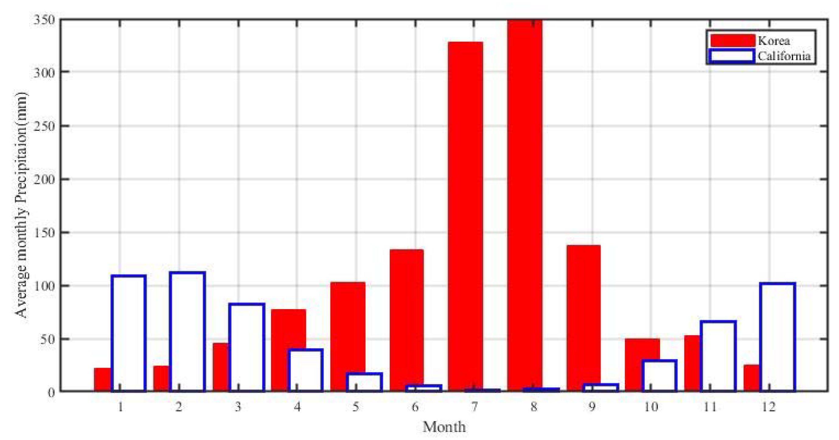
| January | February | March | April | May | June | July | August | September | October | November | December | Mean | Std. | |
|---|---|---|---|---|---|---|---|---|---|---|---|---|---|---|
| Korea | 21.6 | 23.6 | 45.8 | 77 | 102.2 | 133.3 | 327.9 | 348 | 137.6 | 49.3 | 53 | 24.9 | 112.0 | 112.9 |
| California | 108.3 | 111.8 | 81.9 | 39.4 | 16.4 | 6.0 | 1.6 | 2.6 | 6.9 | 29.0 | 65.6 | 101.7 | 47.6 | 43.8 |
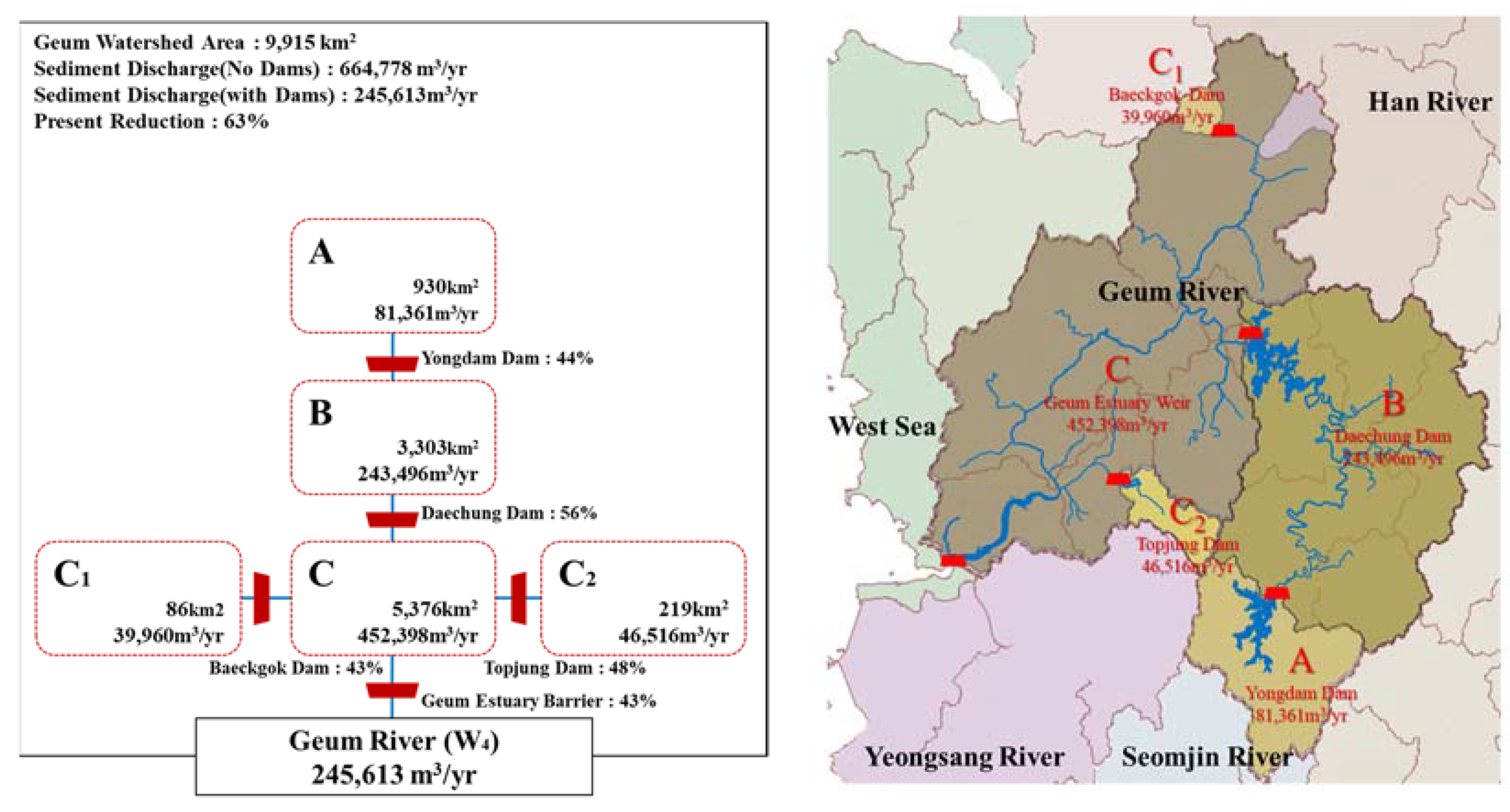
| Name |
Completion Date (yr) |
Storage Capacity (103m3) |
Dam Drainage Area (km2) |
Basin Area (km2) |
Accrued Sediment Discharge (m3/yr) |
Reduced Sediment Discharge (m3/yr) |
Sediment Discharge (m3/yr) |
Reduction Rate (%) |
|---|---|---|---|---|---|---|---|---|
| Yongdam Dam(A) | 2001 | 815,000 | 930 | 930 | 81,361 | 35,536 | 81,316 | 44 |
| Daechung Dam(B) | 1980 | 1,490,000 | 667 | 3303 | 197,671 | 38,614 | 243,496 | 56 |
| Baeckgok Dam() | 1984 | 21,800 | 86 | 86 | 39,960 | 17,063 | 39,960 | 43 |
| Topjung Dam() | 1944 | 31,611 | 71 | 219 | 46,516 | 18,958 | 46,516 | 48 |
| Geum Estuary Weir (C) | 1990 | 138,000 | 537 | 5376 | 299,269 | 26,476 | 245,613 | 43 |
| Total | 2291 | 9915 | 664,778 | 245,613 | 63 |
| Site | Date | Providers | Image No. | Type |
|---|---|---|---|---|
| Area of Janghang Beach in Geum Estuary, Korea | Oct. 1947 | National Geographic Information Institute | 194710000300070005 | Aerial Photo |
| Mar. 1985 | National Geographic Information Institute | 198500000300910002 | Aerial Photo | |
| Apr. 2000 | National Geographic Information Institute | 200004001400090004 | Aerial Photo | |
| Apr. 2003 | National Geographic Information Institute | 200345 | Aerial Photo | |
| Jun. 2010 | National Geographic Information Institute | 20103424 | Aerial Photo | |
| Sep. 2015 | Daum (Korean portal site) | - | Satellite image | |
| Sep. 2018 | National Geographic Information Institute | 201811610A | Aerial Photo |
| Date | ||||||||
|---|---|---|---|---|---|---|---|---|
| #0–#1 | #1–#2 | #2–#3 | #3–#4 | #4–#5 | #5–#6 | Total Area | Avg. Width | |
| October, 1947 | 5697 | 4609 | 5215 | 6798 | 4915 | 4218 | 31,452 | 52.42 |
| March, 1985 | 6667 (+970) | 4324 (−285) | 3208 (−2007) | 4020 (−2779) | 3213 (−1702) | 3867 (−351) | 25,297 (−6154) | 42.16 (−10.26) |
| April, 2000 | 5230 (−1437) | 3150 (−1174) | 1927 (−1281) | 3963 (−56) | 3557 (+344) | 2225 (−1642) | 20,051 (−5246) | 33.42 (−8.42) |
| April, 2003 | 5192 (−38) | 3564 (+414) | 2547 (+620) | 3493 (−470) | 2327 (−1230) | 1589 (−636) | 18,709 (−1342) | 31.18 (−2.24) |
| June, 2010 | 5058 (−134) | 3494 (−70) | 2273 (−274) | 3933 (+440) | 2433 (+106) | 1136 (−453) | 18,330 (−379) | 30.55 (−0.63) |
| September, 2015 | 4272 (−786) | 2759 (−735) | 2220 (−53) | 3317 (−616) | 2660 (+227) | 1763 (+627) | 16,991 (−1339) | 28.32 (−2.23) |
| September, 2018 | 4163 (−109) | 2053 (−706) | 1747 (−473) | 2506 (−811) | 2132 (−528) | 2157 (+394) | 14,758 (−2233) | 24.60 (−3.72) |
| Littoral Cell | |||||||
|---|---|---|---|---|---|---|---|
| Geum Estuary | 19.5 | 12 | 245,613 | 0.84 | 0.025 | 0.37 | 42 |
| 19.5 | 8.5 | 245,613 | 1.05 | 0.035 | 0.37 | 42 | |
| 19.5 | 4.5 | 245,613 | 1.39 | 0.066 | 0.37 | 42 |
© 2020 by the authors. Licensee MDPI, Basel, Switzerland. This article is an open access article distributed under the terms and conditions of the Creative Commons Attribution (CC BY) license (http://creativecommons.org/licenses/by/4.0/).
Share and Cite
Lee, S.; Lee, J.L. Estimation of Background Erosion Rate at Janghang Beach due to the Construction of Geum Estuary Tidal Barrier in Korea. J. Mar. Sci. Eng. 2020, 8, 551. https://doi.org/10.3390/jmse8080551
Lee S, Lee JL. Estimation of Background Erosion Rate at Janghang Beach due to the Construction of Geum Estuary Tidal Barrier in Korea. Journal of Marine Science and Engineering. 2020; 8(8):551. https://doi.org/10.3390/jmse8080551
Chicago/Turabian StyleLee, Sahong, and Jung Lyul Lee. 2020. "Estimation of Background Erosion Rate at Janghang Beach due to the Construction of Geum Estuary Tidal Barrier in Korea" Journal of Marine Science and Engineering 8, no. 8: 551. https://doi.org/10.3390/jmse8080551
APA StyleLee, S., & Lee, J. L. (2020). Estimation of Background Erosion Rate at Janghang Beach due to the Construction of Geum Estuary Tidal Barrier in Korea. Journal of Marine Science and Engineering, 8(8), 551. https://doi.org/10.3390/jmse8080551