Review

The Maturity of Automatic Identification Systems (AIS) and Its Implications for Innovation

1
Management Department, New Jersey City University, Jersey City, NJ 07311, USA
2
Department of Business Administration, Hankyong National University, Anseong 17579, Korea
3
Port & Logistics Research Division, Korea Maritime Institute, Busan 49111, Korea
*
Author to whom correspondence should be addressed.
J. Mar. Sci. Eng. 2019, 7(9), 287; https://doi.org/10.3390/jmse7090287
Submission received: 28 June 2019 / Revised: 7 August 2019 / Accepted: 19 August 2019 / Published: 24 August 2019

Abstract

:
The member states of International Maritime Organization (IMO) have been leading in and enforcing the use of automatic identification systems (AIS) in the analysis of ship-to-ship collisions, vessel monitoring, and maritime traffic management offshore. This study will help non-federal stakeholders understand the AIS data and contribute to future research by assessing difficulties and improving access to data and applications. This study introduces the basics of AIS materials, shared channels, and currently developed applications, and discusses areas where they can be incorporated in the future. The literature revealed that using AIS data will be beneficial to the public as well as to business and public agencies.

1. Introduction

Since antiquity, navigators have determined their course and location by observing other objects on the ground and in the celestial sphere. This approach is vulnerable to adverse climatic/ambient conditions, however, as well as to limitations on the observer’s ability to track and interpret the characteristics of the target objects. Over time, the nature of sea transportation and operations has changed, as the size and speed of ships have increased, along with the sensitivity and value of their cargo. At the same time, the possibility of a significant disaster, and the damage caused by the increased size of vessels and the volume of traffic, has worsened. Our perception of the dangers of sea transportation and tolerance to impacts have also been changing. Loss of life and property at sea, which has been a problem for sailors and travelers, can be prevented by adopting cutting-edge technologies.
People now enjoy the benefits of technological advances that help prevent major maritime disasters or mitigate the consequences of any such events. Today’s crew members are highly educated and trained to use this technology safely and ethically—a fundamental requirement with increasingly sophisticated and complex new ships [1,2].
These positive changes have met not only the conditions for innovation, but also the requirements for technology fulfillment. One such opportunity is for the International Maritime Organization (IMO) to have the vessel fitted with an AIS (automatic identification system) and interpret the trajectory data from the vessel’s navigational operations. AIS was originally developed as an aid to navigation. The maturity of this information technology and information application technology has created opportunities for broader application in many areas, including safety and accident prevention, security, smart infrastructure and operations, transportation planning, cargo management, and the economy [3].
IMO has been leading in and enforcing the use of AIS in ship-to-ship collisions, vessel monitoring, and maritime traffic management offshore. U.S. federal agencies actively access nationwide AIS (NAIS) information to perform a variety of functions, including security, safety, and policy-making.
However, access to the data needed by non-federal stakeholders, including in the marine industry and academic fields, is still limited; AIS data are not very well known, and related research and use is at the preliminary stage. However, if the importance and usefulness of AIS information were known, stakeholders could make rapid progress in the use of the data and its related applications in the near future. Therefore, this study aims to help non-federal stakeholders understand the AIS data and support future research by assessing difficulties and improving access to data and its applications.
This study introduces the basics of AIS materials, shared channels, and currently developed applications, and discusses areas where they can be incorporated in the future. It examines the existing literature relating to AIS data and its derived products of application. The study is structured as follows: first, this study discusses the background and introduces the status of the data in Section 2. Data scientists and information engineers understand the need for data and determine the right information to collect. Because data consumes memory and storage space, it can be expensive depending on the size of the data. This is discussed in Section 3, on the nature of the data and the policy of collecting, using, and sharing data. Views of data science, information management, and governance are described in Section 4. This section describes the methods and tools for collecting, storing, distributing, and visualizing AIS data. Section 5 explores the evolution and development of applications using AIS. Finally, in the concluding section, the research is summarized, with suggestions to increase the accessibility and utilization of AIS data.

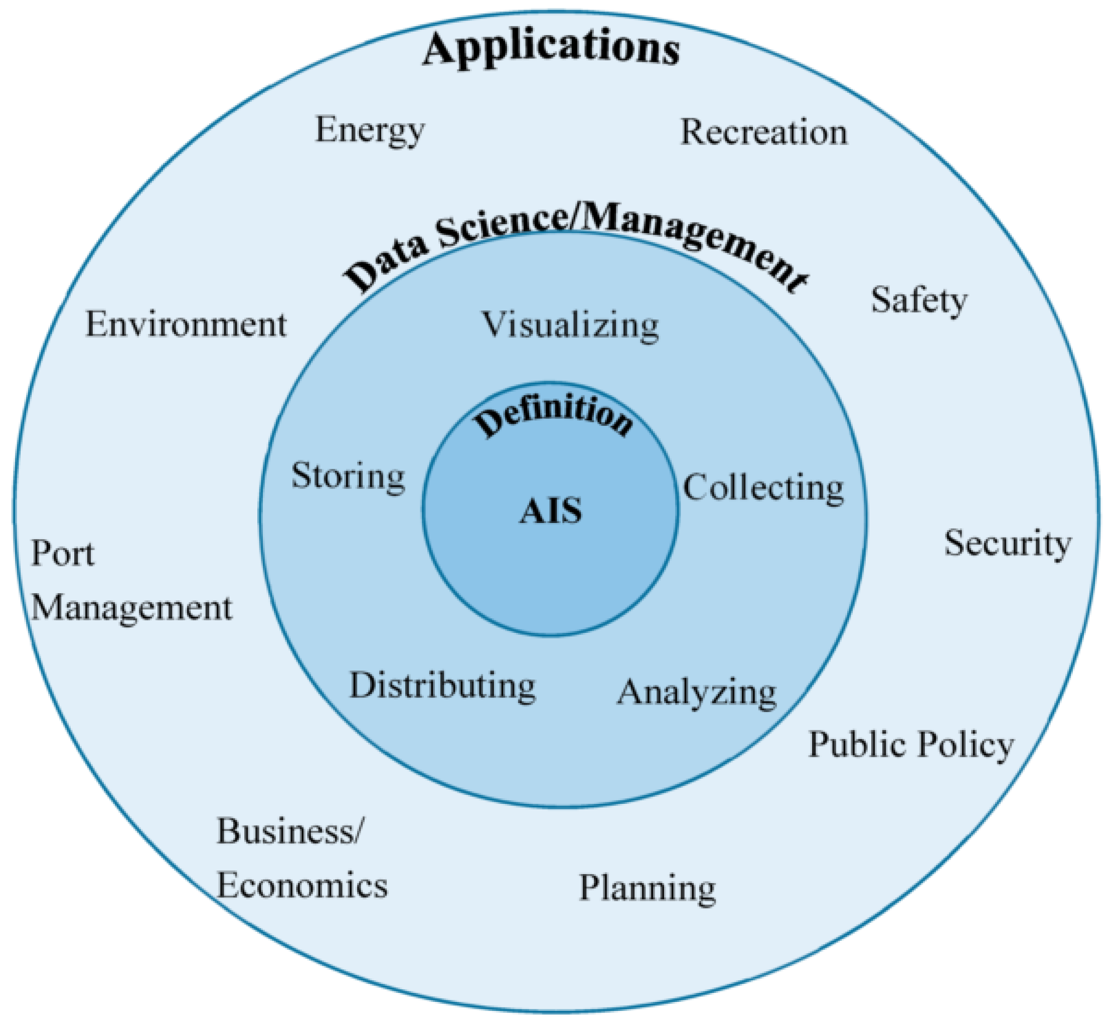
2. Research Framework of Automatic Identification Systems (AIS)

With the development of information and sensor technology, the era of AIS-originated big data has begun. Big Data is immense compared to traditional data and can be analyzed for practical and research applications. Data types and sources have varied, data growth has become very fast, and the speed and accumulation of development have increased in value. Finally, the data have improved in terms of reliability. AIS data are also being utilized to analyze the behavior of vessels with algorithms. The algorithms have advanced and are faster than before through various sources as the scale and accumulation speed of the data have increased. As a result, the information value of AIS increased, along with the demand for the integrity of AIS data for reliable application design and analysis results [4].
The outer circle in Figure 1 describes the application using AIS. These data can be used to secure ships and ports, monitor the behavior of ships for safe operation, and track the location of ships during environmental accidents. The results of the application will be adopted by public policy. Businesses use the data to improve cargo management and increase the efficiency of port operations. This study reviews journals, procedures, and papers published in the database and online. The maturity analysis of this focuses on U.S. applications. The review process mainly focused on the U.S. case, but can easily be applied to other countries.

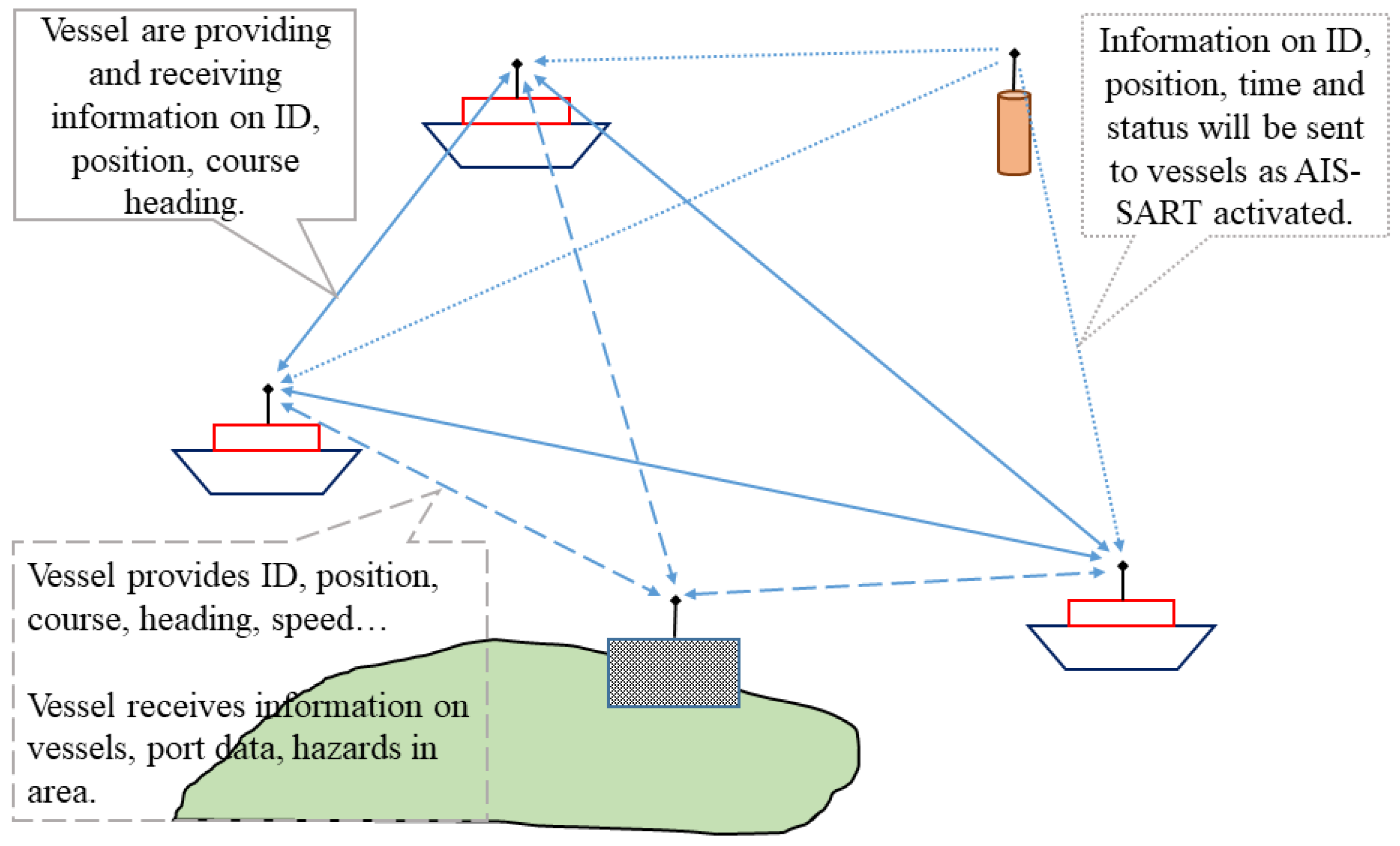
2.1. Technical Specifications and Algorithms

In 2000, the adoption of SOLAS (Safety of Life at Sea) made it a requirement to share AIS data referring to Chapter 5 Regulations 19 (Sharing Carriage Requirements for Ship Navigation Systems and Equipment) [3].
Effective as of 2004, the regulation required ships carrying a total of over 300 tons of cargo to be equipped with AIS, or ships carrying a total volume of over 500 tons of cargo or international or domestic cruise ships regardless of the size of the vessel.
There are four types of information shared by the shipboard AIS (Figure 2). For further information, refer to IMO A 29/Res. 1106.
  • Static, i.e., entered into the system on installation: Maritime Mobile Service Identity (MMSI), call sign and name, IMO number, length and beam, a type of ship and, location of electronic position fixing system (EPFS) antenna.
  • Dynamic, i.e., navigational status and data from ship sensors: ship’s position with accuracy indication and integrity status, position timestamp in coordinated universal time (UTC), course over ground (COG), speed over ground (SOG), heading, navigational status, and rate of turn (ROT).
  • Voyage-related (manually entered and updated during the voyage): ship’s draught, hazardous cargo (type: dangerous goods/harmful substances/marine pollutants), destination and estimated time of arrival (ETA), and route plan (waypoints).
  • Safety-related: free format, short text messages that can be manually entered, addressed either a specific addressee or broadcast to all ships and shore stations.
Data generated and transmitted from the vessel, as shown in Figure 2, can be used for predictive analysis as well as post-event analysis. Since the mandatory implementation of AIS, a variety of new applications have been developed using the derived data generated from the AIS data. Technological advances in data and applications have increased the amount of data collected, as well as the variety of types of data [5].
AIS uses the same transmission frequencies as marine VHF radio and therefore has a similar range of capabilities and restrictions [6]. VHF radio waves, like light, travel in a straight line, and as the earth is curved the maximum range of VHF transmissions is usually considered to be the line of sight, i.e., the optical (visual) horizon [7]. However, the density of the atmosphere has the effect of bending light downwards, which increases the effective (radio) horizon to greater than the visual horizon depending on the prevailing atmospheric refractive index. It is also possible under other atmospheric conditions for the refraction to bend the light upwards, thereby effectively reducing the radio horizon compared to the visual horizon [8].

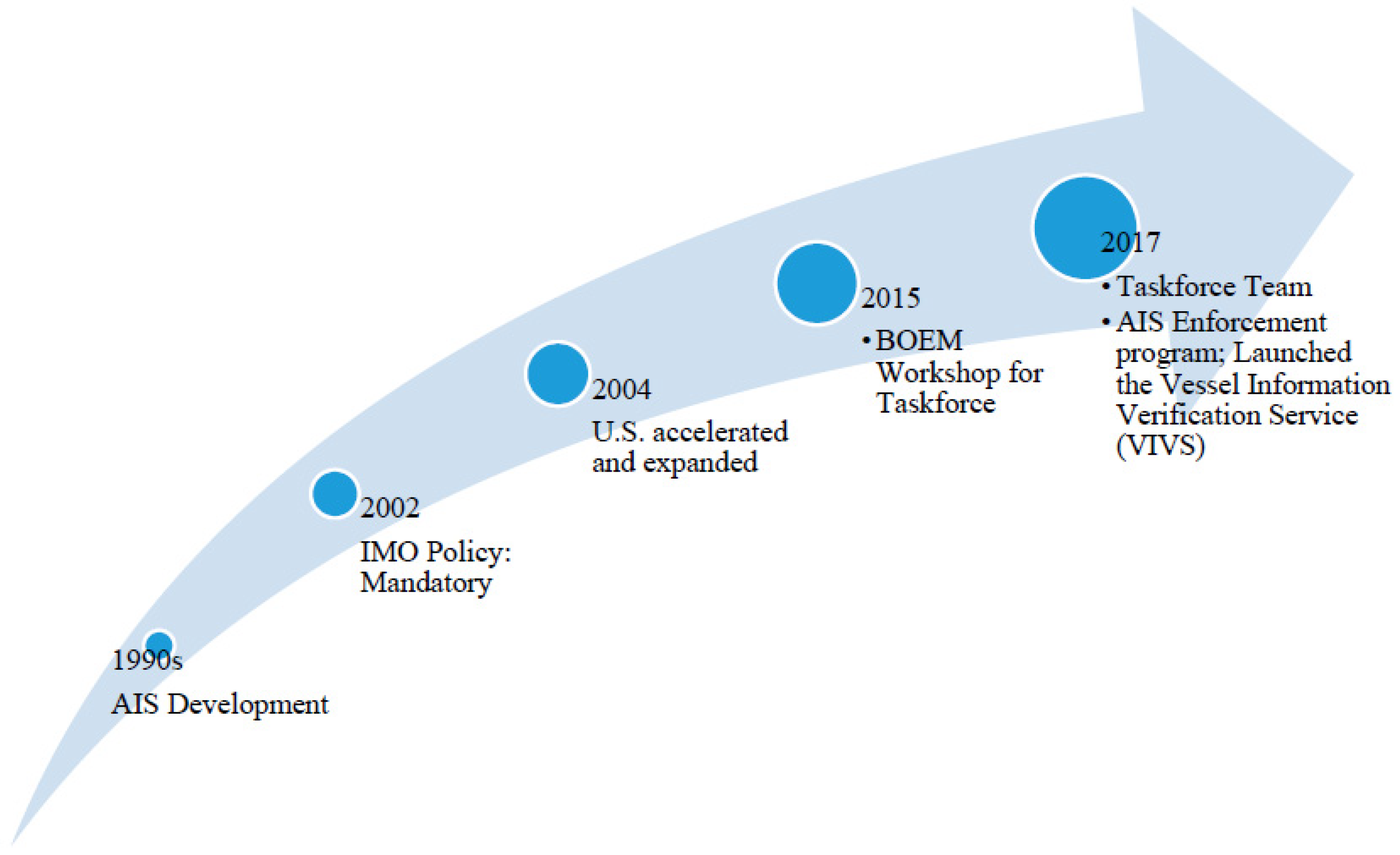
2.2. Policy Regulation and Governance

Major AIS-related international policy guidelines include the International Maritime Organization (IMO), the International Association of Lighthouse Authorities (IALA), the International Electrotechnical Commission, and the International Telecommunication Union (ITU). IMO describes the installation, operation, and use of AIS. These include issues such as installation, performance requirements, training, data protection, messaging, and technology standardization [9]. The U.S. Coast Guard shares the AIS data collected as per the Commandant Instruction 5230.80 and the international policy guidelines.
  • IMO Maritime Safety Committee (MSC), Resolution MSC.74(69): Recommendation on Performance Standards for Universal AIS;
  • IMO Assembly (A), Resolution A.1106(29): Revised guidelines for the onboard operational use of shipborne AIS;
  • IMO Maritime Safety Committee, Resolution MSC.347(91): Recommends that administrations should take the steps necessary to ensure the integrity of the radio channels used for AIS in their waters;
  • IMO Maritime Safety Committee, Marine Safety Circular 1252: Guidelines on annual testing of AIS;
  • IMO Maritime Safety Committee, Marine Safety Circular 1473: Policy on use of AIS aids to navigation (AIS AtoN);
  • IMO Maritime Safety Committee, Safety of Navigation Circular 227: Guidelines for the installation of a shipborne AIS;
  • IMO Maritime Safety Committee, Safety of Navigation Circular 244: Guidance on the use of the UN/LOCODE in the destination field in AIS messages;
  • IMO Safety Maritime Committee, Safety of Navigation Circular 243/Rev.1: Guidelines for the presentation of navigational-related symbols, terms, and abbreviations;
  • IMO Safety Maritime Committee, Safety of Navigation Circular 289: Guidance on the use of AIS application-specific messages;
  • IMO Safety Maritime Committee, Safety of Navigation Circular 290: Guidance for the presentation and display of AIS application-specific messages information.
The accessibility and availability of AIS information will help strengthen coordination to increase the efficiency of the shipping system and support the current direction of data governance. The relevant guidelines are as follows:
  • The White House Cross Agency priority goal for leveraging data as a strategic asset [10];
  • Executive Order 13480: Ocean policy to advance the economic, security, and environmental interests of the United States, and its efforts to publicly release maritime data [10];
  • The Geospatial Data Act of 2018 [11];
  • The Foundations for Evidence-Based Policymaking Act [11].
The U.S. Coast Guards (USCG), supported by the Federal Communications Commission (FCC), is a competent national authority of the AIS and operates the NAIS (Nationwide AIS) network, which provides AIS coverage of selected sections of U.S. coastal waters and inland waters to monitor ship traffic [12].
The Office of Navigation Systems is responsible for establishing requirements, regulations, policies, and program-level guidelines for the deployment, maintenance, and operation of U.S. AtoN and coordinating processes, platforms, and personnel [12].

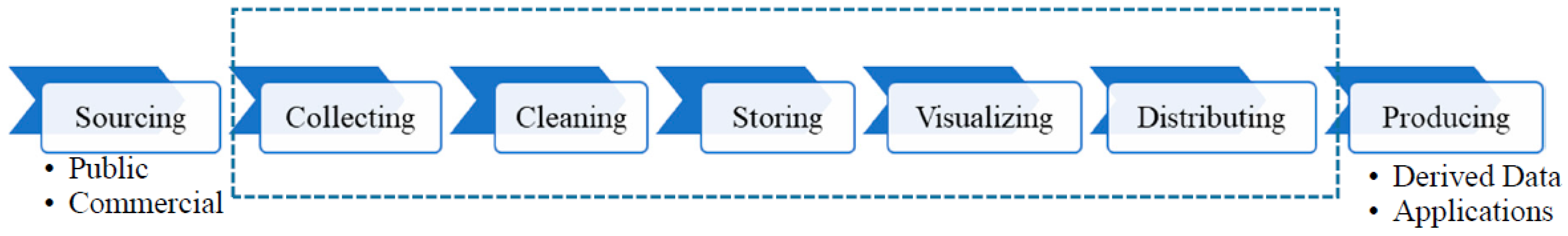
2.3. The Pathway of the AIS Data

A maturity model is widely used to demonstrate that information systems and applications are valuable in evaluating specific aspects of a business process or organization, just as they increasingly change in a systematic and organized way in business [13]. Maturity assessment is used to measure current maturity in a meaningful way, taking into account specific aspects of the organization. This assessment allows stakeholders to identify strengths and improvements and prioritize the challenges they need to address to achieve higher maturity. This study can present practitioners with the options available and opportunities for further study.
There are many different approaches to operating existing theoretical technology maturity models [14], and strategic technology management to make valid, reliable, objective, and useful statements about the maturity of technology, but this study does not analyze the maturity assessment due to the scope of this study; however, it can be conducted in future research. In this study, we briefly review the steps of developing and adopting AIS (Figure 3).
1990s: AIS was developed to promote ship-to-ship navigation safety and to promote potential ship traffic services [12].
1998: IMO Resolution MSC. 74(69), Annex 3, Recommendation on Performance Standards for Universal Shipborne Automatic Identification Systems (AIS).
1998: ITU Recommendation M.1371-0, Technical characteristics for a universal shipborne automatic identification system using time division multiple access in the VHF maritime mobile band (superseded).
2001: International Electrotechnical Commission, IEC 61993-2 Ed.1, Maritime navigation and radio communication requirements—Automatic identification systems (AIS)—Part 2: Class A shipborne equipment of the universal automatic identification system (AIS)—Operational and performance requirements, methods of test and required the test results.
2001: ITU Recommendation M.1371-1, Technical characteristics for a universal shipborne automatic identification system using time division multiple access in the VHF maritime mobile band (Superseded).
2001: IALA Recommendation on AIS Shore Stations and Networking Aspects Relating to the AIS Service, Edition 1.0.
2002: All ships of over 300 gross tonnage were mandated to provide AIS by the International Maritime Organization (IMO) regardless international voyage. The policy also requires cargo ships of over 500 gross tonnage on non-international voyages [12].
2003: IMO Safety of Navigation Circular 227, Guidelines for the installation of a shipborne automatic identification system (AIS) [12].
2004: IMO Safety of Navigation Circular 244, Guidance on the use of the UN/LOCODE in the destination field in AIS messages.
2006: ITU Recommendation M.1371-2, Technical characteristics for a universal shipborne automatic identification system using time division multiple access in the VHF maritime mobile band (superseded).
2007: ITU Recommendation M.1371-3 Technical characteristics for an automatic identification system using time division multiple access in the VHF maritime mobile band (superseded).
2007: IMO Marine Safety Circular 1252, Guidelines on annual testing of the automatic identification system (AIS).
2010: ITU Recommendation M.1371-4, Technical characteristics for an automatic identification system using time-division multiple access in the VHF maritime mobile band (superseded).
2010: IMO Safety of Navigation Circular 289, Guidance on the use of AIS application-specific messages.
2010: IMO Safety of Navigation Circular 290, Guidance for the presentation and display of AIS application-specific messages information.
2012: IMO Resolution MSC.347 (91) recommends that administrations should take the steps necessary to ensure the integrity of the radio channels used for AIS in their waters.
2014: ITU Recommendation M.1371-5 (02/2014), Technical characteristics for an automatic identification system using time-division multiple access in the VHF maritime mobile band.
2014: IMO Safety of Navigation Circular 243/Rev.1, Guidelines for the presentation of navigational-related symbols, terms and abbreviations.
21015: IMO Resolution A.1106 (29), Revised guidelines for the onboard operational use of shipborne automatic identification systems (AIS).
2016: IALA Recommendation on AIS Shore Stations and Networking Aspects Relating to the AIS Service, Edition 2.0.
2017: U.S. Coast Guard Navigation Center (NAVCEN) began to provide a service of the Vessel Information Verification Service (VIVS) to maritime stakeholders including mariners, vessel traffic service (VTS), Marine Inspectors, and Boarding Team via online. Prior AIS requirement has become an important fuel of quality improvement of NAIS data since the VIVS was accessible to the public for verifying the reliability of the AIS data [12].

3. A View of Data Science and Informatics

Data science is a multi-disciplinary field that covers how to collect, process, store, visualize, and distribute data (Figure 4). This chapter discusses who collects AIS data, as well as how to filter out outliers and create an appropriate format. It also discusses how to allocate raw and processed information to users who need the data through a visualization process.
Depending on the timeliness of the data, AIS data can be divided into real-time data transmitted from the vessel and historical data collected, processed, and stored for analysis purposes. The data are also categorized into raw data and derived data from the original AIS data. These are divided into U.S. coast, inland waters, and St. Lawrence Seaway, according to the geographic coverage of the vessels collecting data.

3.1. Collecting

The U.S. Coast Guard (USCG) collects AIS vessel traffic data generated on-board by navigational safety devices. The device monitors and transmits the location of ships and the characteristics of ships in U.S as well as international waters in real time. In cooperation with the U.S. Coast Guard, commercial data providers also collect AIS data [15]. For desktop GIS software, the data includes navigation location, time, speed and ship type, length, and beam and draft information. This information is mainly used by federal agencies such as the Bureau of Ocean Energy Management (BOEM), the National Oceanic and Atmospheric Administration (NOAA), and the USCG.
AIS technology uses global positioning systems (GPS), navigation sensors, and digital very high frequency (VHF) radio communication equipment to exchange vessel navigation information between other vessels and shore-side stations. The data sent and received at this time include the information given in Section 2.1. The information is collected and continuously updated by the nearby AIS shore station (Figure 2) [12].
Nationwide AIS (NAIS) is an integrated system that includes AIS base stations, data storage, and processing and networking infrastructure. NAIS consists of approximately 130 AIS stations located on the coast of the United States, inland waterways, Alaska, Hawaii, and Guam. NAIS collects AIS transmissions at least 50 nautical miles off the coast, including at 58 critical ports and 11 waterways across the USCG and other federal, state, and municipal governments. The fundamental goal of NAIS is to increase marine domain awareness, with a focus on improving data collection and dissemination through the network infrastructure, especially maritime security, maritime and navigation safety, search and rescue, and environmental protection services. NAIS is also integrated with other systems for infrastructure sharing, rapid deployment, and performance improvement [12].
Enforcement of the AIS rules plays an important role in improving the quality of NAIS data. In 2017, the USCG Navigation Center (NAVCEN) launched an online tool called the Vessel Information Verification Service (VIVS), providing public access to the reliability of AIS sent to the crew, VTS, marine inspectors, boarding teams, and other maritime stakeholders. VIVS is a key component of the USCG’s AIS hardening program and is designed to improve safe navigation by reducing inconsistencies. For effective use of AIS dynamic data in collision avoidance, the completeness and integrity of the data should be ensured [16,17]. Fewer errors in AIS data mean high AIS data quality [12,18,19], resulting in reliable and timely decision analysis derived from the data.

3.2. Cleaning

To ensure the quality and ease of use of the data, the data are filtered, reformatted, and reconstructed. Data have been recorded since 2009, and each record is filtered in 1-min increments and available in a compressed monthly format in Universal Transverse Mercator (UTM) zoning units. In order to share the original data with the public, the fields in the ship name and call sign are deleted, and, at the request of the US CG, in the 2010–2014 data, the Maritime Mobile Service ID (MMSI) was also encrypted [15].
USCG’s Authoritative Vessel Identification Service (AVIS) examines the AIS data received from ships, performs analyses of collected data, and compares the information identifying the ships with other databases to determine the actual identity and characteristics of the vessels. It can be used as a “correct” process if the AIS information sent by the vessel is entered incorrectly. AVIS creates a vessel complex identification recognizer by combining (1) various ID fields at the AIS location with vessel information recognized through static navigation messages and (2) ship information combined and compared through other sources.
AVIS maps the source of AIS messages to a unique vessel through a computer algorithm or human verification and provides a function to track a designated vessel’s historical identities. AVIS also increases the quality of basic identification information contained in the AIS message, along with data such as official numbers, build years, documented dimensions, owner/operator, and wireless licenses provided by the official authority to provide complete, reliable, and authoritative ship information [12].
All applications using AIS are classified into areas of prediction, clustering, and visualization, which increases the reliability of the results with the introduction of an advanced analytical technique such as machine learning, but the desired route of the vessel must extract key feature points from the AIS trajectory for the introduction of advanced analyzer methods [4].

3.3. Storing

Reconfigured 2010–2014 data are stored in the file format of the geo-database (*.gdb). The dataset has been distributed to users since 2015 in comma-separated values (CSV) format [15]. Datasets from 2014 to 2017 have missing and outdated values in the automatic vessel identification service (AVIS), but have not been modified. In addition, the data generated during this period are not MMSI-encrypted, unlike the 2010–2014 data.

3.4. Visualizing

Visualization of the data is an important step in communicating the processed information to the data user. Visualization is not only a quick way of delivering information, but also an important tool for aiding decision-making. The National Oceanic and Atmospheric Agency (NOAA) provides guidelines for visualizing the current state of ship density. MarineCadastre.gov provides the steps and tools required to create a ship density map using historical AIS data [20]. The visualization also aims to help expert users discover the relationship between spatial, temporal, and vessel-type attributes [21].

3.5. Distributing

The AIS data are prepared for analysis and intended for distribution using desktop GIS software. In addition, BOEM and NOAA work together to collect guidance on tools and instruction materials. This allows analysts to improve their understanding of offshore site analysis and marine transportation patterns by processing the data and creating applications [15,22]. NOAA (2015) provides documentation that covers three main steps: (a) setting up with data and software; (b) generating route tracking; and (c) creating density grids.
Information derived from AIS data provides the U.S. government and other maritime stakeholders with a great opportunity to enhance the safety, efficiency, and security of marine transport systems. Access to applications using data and materials from non-federal agencies and stakeholders is not the primary objective of the U.S. Committee on the Marine Transportation System, but it should be noted that significant interagency work is driven by nonfederal needs and the federal agency’s data access needs also benefit nonfederal audiences [12].
AIS data are distributed by NOAA, BOEM, NAVY, USACE, and USCG [12]. NOAA and BOEM jointly manage the geographic information system (GIS)-based marine data viewer and repository, which provides decision-support tools for offshore renewable energy, mineral extraction, fisheries, and other activities.
Since 2009, federal agencies have been releasing and distributing USCG NAIS data in GIS format. MarineCadastre.gov also stores coastal NAIS information from 2009 to 2017 and provides data to the public. However, the data available here can only be downloaded in predefined time units and geography units.
MarineCadastre.gov provides end-users with tools to create AIS-derived products using AIS, including route tracking, vessel density maps, and the number of movements, web map services, instructions, and software for desktop GIS users. These data, tools, and supporting documents are available to the public for a wide range of offshore and marine management, planning, research, industry, and academic purposes [12].

4. Review of Algorithms and Applications

Information derived from the AIS data (Table 1) provides the U.S. government and other maritime stakeholders with an excellent opportunity to enhance the safety, efficiency, and security of marine transport systems [12]. For convenience, if this study divides the categories classified by the federal government into subcategories, including application graphs developed by non-governmental organization users; they can be categorized as follows: waterways management, safety and security management, marine and environmental planning, natural resources management, and freight and environment management.

4.1. Waterways Management

The Automatic Identification System Analysis Package (AISAP) performs vessel traffic analysis on U.S. coastal and inland waterways based on AIS data. This allows most data queries to be processed and returned to the user via machine-to-machine interaction [12,23].
SeaVision15 is a web-based marine awareness tool that enables users to view and share a variety of ocean information. To help manage information, SeaVision provides a customized rule-based analysis to assess and notify of predefined marine activities or events. While the Maritime Safety & Security Information System (MSSIS) network contains only shared AIS data from participating governments, SeaVision is also a visualization and management tool that can quickly add and correlate multiple data sources, including images or ship locations derived from coastal radars, to meet various maritime mission needs. SeaVision implements access controls that allow the data owner to specify deployment privileges. The application may include subcategories such as vessel-to-vessel exchange of information, analyze ship traffic for navigational risk, inform vessels of hydrographic survey locations and chart adequacy, lock operations situational awareness, inland and coastal waterways operations, and track movement of United States Fleet Forces (USFF).
Various mining techniques would be applied using voluminous AIS data to find patterns of vessel movement. Mascaro et al. [24] applied machine learning by applying both dynamic and static Bayesian network models to Sydney harbor. The algorithm could identify anomalies. Similarly, Handayani et al. [24] described and applied a support vector machine (SVM) to detect anomalous behavior of the vessels.

4.2. Safety and Security

4.2.1. Safety and Accident Prevention Applications

The safety applications of using AIS data may include waterways management risk assessment, coastal and marine planning, port management, fishing, reconnaissance performance, environmental compliance, marine mammal avoidance, and cargo statistics analysis for federal and public stakeholders [12].
The U.S. Army Corps of Engineers (USACE) uses AIS to support lock operations, waterways monitoring, ship navigation safety information communication, and more. USACE uses AIS data for navigation planning studies, improving the efficiency of reporting necessary information from locking facilities, and modifying data submitted by commercial ship operators.
USACE has developed a robust analysis of AIS data that provides insight into ship operations related to industrial infrastructure managed by the agency (e.g., dredging channels, breakwater, and locking devices). This analytical capability has also been applied to investigate topics such as ship behavior in important habitats, underwater accident investigations, and typhoon-damaged port resilience [12,25].
A case study of the Port of Shenzhen City was conducted to investigate the relationship between accidents and vessel traffic using AIS data [26]. The case study utilized geographic information systems (GIS) with the historical AIS data over a 10-year-span, including traffic flow, ship speed, and heading variance.
The AIS data are also used to detect currents. Kanarik et al. [27] predicted the drift of vessels using an acoustic doppler current profiler (ADCP) and verified the data with AIS in 2013 in the Finnish Archipelago Sea.

4.2.2. Security

The Maritime Safety & Security Information System (MSSIS) is a government AIS data-sharing network developed and operated by the U.S. Department of Transportation (USDOT) Volpe Center and funded by the U.S. Navy. MSSIS combines AIS data from 74 participating countries (including USCG-NAIS and USACE LOMA as contributors from the United States) into a single raw AIS NMEA 0183 data stream [28,29] to provide up to 150 million reports of vessel locations per day [20].
MSSIS allows participating governments to upload local real-time AIS data and receive the entire integrated stream again. Two AIS data platforms (Transview and SeaVision) can be used to display and transform AIS data [12].
Like other federal agencies-run domestic AIS systems, the Seaway AIS is compliant with the Maritime Transportation Security Act of 2002. The law requires certain ferries and other high-interest vessels, such as fuel tankers and hazardous material carriers, to carry an AIS device within the navigable waters of the United States, as of 2003. In 2013, the Saint Lawrence Seaway Development Corporation (SLDC) and the St. Lawrence Seaway Management Corporation (SLSMC), the successor to the St. Lawrence Seaway Authority, revised their joint regulations to mandate the use of AIS in Seaway from Saint-Lambert in Québec to Long Point in Ontario, Canada [12,30].
The U.S. Maritime Administration (MARAD) used AIS data for a project to visualize the vessel’s location and course in the Maritime Security Program (MSP). The MSP can call up to 60 U.S.-flagged merchant ship fleets in national emergencies, such as armed clashes or natural disasters. This information aids decision-making in response to an emergency by advising on which MSP vessels are available in a given area [12].
The National Weather Service (NWS) uses historical AIS to analyze vessel practices that ignored dangerous weather and weather warnings. The project plans to integrate and expand weather information and ship locations in real time. In order to improve the Voluntary Observing Ship Program, whereby ships send automated weather observations, the NWS is conducting a pilot project to link the data with AIS information. The goal is to increase the number of meteorological observations and improve the quality of weather forecasts [12].
The Coast Guard uses electronic navigational aids to transmit information about damaged aids to navigation through the Nationwide AIS, whereby ships sailing nearby can be identified by radar or electronic charting system to avoid any risks [9].
During three hurricanes arrived in the United States in September 2017, the USCG successfully leveraged electronic aids to navigation (e-AtoN). Following the devastation of Hurricane Harvey, the USCG employed e-AtoN to temporarily mark physical AtoN that were destroyed or damaged along the Gulf Coast. The location of the individual e-AtoN, which were transmitted over the Nationwide Automatic Identification System (NAIS), could be “seen” by any navigators with a radar and/or electronic charting system which are able to display AIS information. In addition, a portable AIS system was deployed to the affected regions in Texas as a backup to the NAIS network. These efforts contributed to the reopening of the Port of Aransas, Texas several days sooner than physical AtoN restoration allowed. The relevant applications may include risk assessment, maritime domain awareness, weather forecast awareness for safety at sea, incident investigation, quantifying the level of disruption from storms or other events, and enforcement [12].
Safety and security-related applications, in particular, need to analyze vessel behavior quickly and accurately. A dual-polarization-based algorithm that recognizes ships in an offline tool and analysis risks by 5% based on established thresholds has been introduced off the Pacific coast of Mexico [31].

4.3. Marine and Environmental Planning

BOEM uses AIS data to support the needs of marine planning related to offshore energy development. BOEM wants to use the data to understand the past usage behavior and usage of existing users in coastal areas. This information is used to perform spatial analysis to inform on location selection, safety and risk analysis, environmental material emission analysis, and development plan assessment [12].
The Environmental Protection Agency (EPA) is developing models using AIS records to estimate emissions from commercial vessels in three categories operating in U.S. waters using information about the speed and location of vessels at anchor [32]. Currently, AIS is the most comprehensive and detailed source of analysis of activity types by vessel type required to perform these calculations. EPA uses this type of exhaust gas model to better understand emissions contributions from different vessel types across the country and assess their impact on public health [12].
The UN Conference on Trade and Development (UNCTAD) predicted that global shipping would grow by nearly 3% in 2017. Increasing consumption in emerging markets will keep the transportation demand high [33]. In the absence of special ship environmental regulations, IMO estimates that the emissions from marine transport may increase by 250%, in the worst cases, by 2050. The European Union (EU) estimates that transportation will account for one-fifth of global emissions by 2050 [34].
Freight shipping using vessels is very efficient in terms of fuel consumption, but the heavy fuel oil (HFO) used by 80% of the world’s shipping vessels is an unwelcome material. It is more carbon-intensive than other fuels and releases air pollutants such as sulfur dioxide (SOx), which causes acid rain, as well as other greenhouse gases. Countries have banned the use of HFOs in Antarctica due to fears of contamination and oil spills that could damage the ecosystem. A similar ban has been introduced in the Arctic.
The Organization for Economic Co-operation and Development estimates that new and renewable energy can almost completely decarbonate the shipping industry by 2035. The reduction is equivalent to emissions from 185 coal plants per year. Although these ambitious goals are technically feasible, political constraints are an important challenge to address. Ships are long-term capital investments, so it is expected to be expensive to dispose of and replace old models before their natural lives are over.
AIS cannot directly reduce emissions, but can monitor and control emissions, which can greatly improve the environment. Since AIS is a technology that tracks all information about ships and routes, it can provide information on where and when ships produce emissions [35]. The amount of pollutant emissions can be predicted using ship maritime mobile service identity (MMSI), navigational speed, the initial location and type of vessel, and the density in the area of vessel crossing or docking.
AIS is currently proving its value in real-time collision avoidance, marine habitat management, and marine casualty investigations. Transportation costs and carbon emissions are much lower than those for land transport, and transportation continues to empower less developed countries as a cost-effective means of improving the economy. In order to identify potential contributions to ship transport and marine oil pollution, it is advisable to provide a snapshot of the number and type of ships currently in operation.
With regard to the use of AIS data and related technology to minimize marine oil pollution, current offshore oil spills are classified into three categories: oil spills from maritime accidents; oil and oil spills from ports and waterways; and illegal discharges of oil or oil waste.
The ability to receive AIS messages over a wide range of coverage areas has led to the use of AIS for a range of coastal and marine management tasks. Tracking and responding to environmental incidents using AIS is becoming a concern of USCG and NOAA. To address concerns about oil pollution in the European oceans, this study has implemented an international program to detect illegal oil dumping at sea and allow law enforcement on ships violating the marine pollution (MARPOL) regulations. In an effort to reduce oil pollution on European shores and oceans, for example, a Norwegian program uses AIS data to assess the risk of oil spills associated with certain ships. AIS will be an important component of the technology that will help investigate and determine future procedures for responding to oil spills and their responsibilities. IMO utilized the AIS data to estimate pollutant emissions based on vessel classifications nationally and geographically. Thus, without the data, IMO can only roughly guess the emissions, resulting in a higher bias [36].
Other subcategories of AIS application for marine and environmental planning include coastal and ocean planning, ocean energy development, calculating emissions inventories related to ship movements, quantifying the level of disruption from storms or other events, and marine mammal avoidance.

4.4. Natural Resources Management

NOAA uses AIS data to monitor and analyze fishing activities, improve marine mammal protection, and prioritize charting and surveying activities based on measured navigational traffic [12].
Coastal countries around the world are experiencing significant economic losses from illegal, unreported, and unregulated (IUU) fishing activities, and are engaged in a variety of activities to regulate and patrol them [37,38]. The visible embedded imaging radar water (VIIRS) vessel detection method for fishing and other vessel recognition off the coast of India has introduced an algorithm that complements AIS data with vessel monitoring systems (VMS). In order to monitor illegal fishing vessels off the coast of Ghana, radar images are obtained from Sentine-1, a multispectral imager is obtained through Sentine-2, and AIS data are compared with the information of ships [37].
Similarly, the Mar-UAV system, which identifies vessels by mixing aerial images and AIS information transmitted from unmanned aerial vehicles (UAVs), uses a multifeature and multilevel matching algorithm that compares vessel and navigation information with AIS data after ousting the target ship’s image [39]. This algorithm can improve accuracy with machine learning. In order to monitor illegal fishing in the North Sea, a high-resolution commercial synthetic aperture radar (SAR) image and AIS data are compared using the random forest (RF) algorithm, one of the machine learning techniques [38].
With UAVs, which are often used for safety, information collection, rescue, and environmental monitoring activities in maritime management, a ship’s activities can be monitored and its course tracked down, but information such as the ship’s name or recognition number is not known, so the vessel’s time and space information can be corrected by combining it with AIS data [39].

4.5. Freight Management and Economics

Under the container model suite of tools, a series of desktop programs and associated database sets support USACE planners and port analysts. Analysis and pre-processing (A-DAPP) is an advanced spatial analysis tool that can analyze container vessel activity based on AIS data. A-DAPP uses vessel properties and port information from AIS messages and other sources. The A-DAPP function includes identifying routes and services by container vessel advance, developing statistical information on arrival and departure flows, calculating statistics on the time spent by ships at docks, determining the vessel speed at various points along the route, sharing journeys, and other interval calculations. This describes statistics by vessel classification, service, and route group. Combining the data with a planning-level tool makes it easy to facilitate economic analysis of proposed navigation improvement projects in coastal ports [12,40,41].
The Bureau of Transportation Statistics (BTS) uses AIS data to develop high-resolution and timely statistics on port and terminal use. For example, BTS used the USCG NAIS’ AIS vessel location report (in cooperation with USACE) to analyze container ships’ and tankers’ dwell times within the spatially defined port boundaries to generate rich statistical information to support the Port Performance Freight Statistics program. With many observations collected, BTS was able to calculate meaningful summary statistics, including on U.S. container ship and oil tanker dwell times, and the monthly dwell time indices for each port area. BTS also used AIS data to visualize ferry routes to support the National Census of Ferry Operators. BTS is also exploring applications with AIS data to calculate cruise ferry statistics [12].
The route can be visualized by marking it on a map using information about the major shipping routes and ports for global ships. This information can also be used as a validation for simulation studies to locate the vessel’s shortest sailing route and optimize its schedule [42].
AIS data can be used to calculate the technical and operational efficiency of ships and navigation. In order to improve the global environment, the ship’s design and engine have been improved. As part of the verification of the benefits of changing vessel technology and operations, AIS information can be used to reverse-track its energy efficiency and operational efficiency.
AIS data are used to measure ship speed. This is done not only in U.S. ports, but also in other major ports around the world to determine the compliance of slow or speed-reduction programs for ships being introduced to build eco-friendly ports. This is because, with the voluntary participation of shipping companies, incentives can be provided to those who agree to a reduction in speed, and the effect of deceleration can be calculated [43,44,45,46].

5. Discussion

Difficulties in the use of AIS information include policy and technical barriers to interagency data sharing related to cybersecurity and information assurance policies, and the inability to access data in a timely manner (Table 2). Other challenges are inconsistent data formats and quality, impractical access to long-term data storage, and the need to validate data with third-party sources. AIS also requires the need for standard analytic products or decision-making tools for users with limited capacity or expertise [12].
While some federal agencies use sister agency-provided AIS information, many federal agencies purchase AIS data from commercial data vendors, paying a high price for products purchased to fill information gaps and geographic areas that are not met by NAIS. In addition to commercially purchasing AIS data, agencies are also purchasing additional vessel classifications and other marine-related databases to correlate and verify their information, including IHS/Lloyds and Clarkson. Resources spent to meet the agency’s analytical needs include data, as well as data scientists and information engineers (i.e., people) and computing capabilities (i.e., hardware and software).
Since not all ships are AIS data- and VMS (vessel monitoring system)-compliant, they also use supplementary information such as synthetic aperture radar (SAR) in satellite remote sensing (RS) for vessel recognition [31,38]. High-frequency surface-wave radar (HFSWR) for monitoring maritime crimes in the Gulf of Guinea’s economic exclusive zone (EEZ) also showed the use of land and satellite ANIS data to compensate for technical shortcomings that increase the need for a low signal [47].
U.S. federal agencies are often required to validate AIS information using other data sources to ensure robust analytics and decision-making capabilities. This also includes connections to USCG databases such as AVIS, U.S. Customs, and Border Protection, or databases provided by the Census Bureau and other historical federal datasets. The AIS information must also be readable by other systems, including both the navigation software and the geospatial analysis program. AIS information is often overlaid with environmental information, including radar and satellite images, with electronic navigation chart systems or plotters.
Apart from USCG, other agencies store AIS data independently for several reasons with varying levels of management. This includes archiving data purchased by USCG and previously requested data. Non-USCG agencies say that storing data is easier than making multiple requests to the USCG. USACE has a short-term, 45-day temporary archive for internal use of its AIS data. USCG NAVCEN stores three years of AIS data in a format accessible through HDR, and NAIS records kept by MarineCadastre.gov date back to 2009, the oldest period of information accessible to end-users [12].
Manmade disasters such as the event that occurred in the Danube River in Budapest, Hungary could be prevented by the vessel’s automatic navigation system by mutual recognition and response to risks between ships using AIS data [48]. The data should be used to save lives, protect the environment, and improve the economy.

6. Conclusions

This study conducted a literature study based on publicly available reports and data. The research is focused on identifying the current usage and status of the United States as a result of the increasing global demand for AIS data and the development of related technologies. The study reviewed AIS data and looked at historical developments. This study divided AIS data into the processes of collecting, cleaning, storing, visualizing, and distributing, and applications were divided into waterways management, safety and security management, marine and environmental planning, natural resources management and freight, port management, and the economy to understand the status and level of development.
Research has shown that data are subject to a time lag, and that the verification and allocation of data are not integrated for reasons of divergence of management and federal administration, making it less accessible, timely, and reliable for end-users. Future research should encompass a maturity analysis of federal and non-federal stakeholders in the context of AIS data sourcing, collecting, cleaning, storing, visualizing, distributing, and producing.

Author Contributions

Conceptualization, E.S.L., A.J.M.; methodology, E.S.L.; literature review, E.S.L., A.J.M., S.Y.M., G.S.K.; writing—original draft preparation, E.S.L., A.J.M., S.Y.M.; writing—review and editing, E.S.L., A.J.M., G.S.K.; visualization, E.S.L., A.J.M.

Funding

This research received no external funding.

Acknowledgments

This study was conducted while Sang Young Moon and GeunSub Kim visited New Jersey City University (NJCU) as visiting scholars.

Conflicts of Interest

The authors declare no conflict of interest.

References

  1. IMO. Focus on IMO: The New STCW Convention; International Maritime Organization: London, UK, 1997. [Google Scholar]
  2. IMO. Adoption of the Final Act and Any Instruments, Resolutions and Recommendations; Resulting from the Work of The Conference; Coast Guards: Washington, DC, USA, 2010. [Google Scholar]
  3. IMO. Regulations for Carriage of AIS. (I. M. Organization, Producer), AIS Transponders. 2019. Available online: http://www.imo.org/en/OurWork/Safety/Navigation/Pages/AIS.aspx (accessed on 2 August 2019).
  4. Gao, M.; Shi, G.Y. Ship Spatiotemporal Key Feature Point Online Extraction Based on AIS Multi-Sensor Data Using an Improved Sliding Window Algorithm. Sensors 2019, 19, 2706. [Google Scholar] [CrossRef] [PubMed]
  5. Mokashi, A.; Stewart, R.D. Expanding the Capabilities and Use of Automatic Identification Systems (AIS). In Logistics, Trade, and Transportation Symposium; Center for Logistics, Trade, and Transportation (CLTT): Gulfport, MS, USA, 2014. [Google Scholar]
  6. Marine Milltech. What is the Range for AIS Receivers? Available online: https://www.milltechmarine.com/faq.htm#a5 (accessed on 2 August 2019).
  7. Seybold, J.S. Introduction to RF Propagation; Wiley: Hoboken, NJ, USA, 2005; p. 330. [Google Scholar]
  8. Winder, S.; Davies, J.; Carr, J.J. Newnes Radio and RF Engineering Pocket Book; Newnes: Oxford, UK, 2002; Volume 3. [Google Scholar]
  9. U.S. Coast Guard. Maritime Commerce Strategic Outlook; Coast Guard: Washington, DC, USA, 2018. [Google Scholar]
  10. White House. Executive Order Regarding the Ocean Policy to Advance the Economic, Security, and Environmental Interests of the United States; Executive Orders: Washington, DC, USA, 2018. [Google Scholar]
  11. U.S. Congress. Geospatial Data Act of 2018 (GDA), (P.L. 115–245), H.R. 302, Subtitle F. Sections 751–759. Washington, DC, USA, 2018. Available online: https://www.fgdc.gov/gda/geospatial-data-act-of-2018.pdf (accessed on 2 August 2019).
  12. U.S. CMTS. Enhancing Accessibility and Usability of Automatic Identification Systems (AIS) Data: Across the Federal Government and for the Benefit of Public Stakeholders; U.S. Committee on the Marine Transportation System: Washington, DC, USA, 2019.
  13. Proença, D.; Borbinha, J. Maturity Models for Data and Information Management. Lect. Notes Comput. Sci. 2018, 11057, 81–93. [Google Scholar] [CrossRef]
  14. Albert, T. Measuring Technology Maturity: Theoretical Aspects; Springer Science and Business Media LLC: Berlin, Germany, 2016; pp. 9–113. [Google Scholar]
  15. Office for Coastal Management. Vessel Traffic Data; NOAA: Washington, DC, USA, 2018.
  16. Felski, A.; Jaskólski, K. The Integrity of Information Received by Means of AIS During Anti-collision Manoeuvring. TransNav Int. J. Mar. Navig. Saf. Sea Transp. 2013, 7, 95–100. [Google Scholar] [CrossRef] [Green Version]
  17. Felski, A.; Jaskólski, K.; Banyś, P. Comprehensive Assessment of Automatic Identification System (AIS) Data Application to Anti-collision Manoeuvring. J. Navig. 2015, 68, 697–717. [Google Scholar] [CrossRef] [Green Version]
  18. Felski, A.; Jaskólski, K. Information Unfitness of AIS. Annu. Navig. 2012, 19, 17–24. [Google Scholar] [CrossRef]
  19. Hori, A.; Arai, Y.; Okuda, S. Study on Application of Real Time AIS Information. In Proceedings of the Asia Navigation Conference, Jeju, Korea, 20–21 October 2006; Korean Institute of Navigation and Port Research: Busan, Korea, 2006; pp. 63–70. [Google Scholar]
  20. MarineCadastre.gov. Tutorial: How to Build Vessel Density Maps with AIS; Bureau of Energy Management & NOAA: Washington, DC, USA, 2015.
  21. Willems, N.; Van Hage, W.R.; De Vries, G.; Janssens, J.H.; Malaisé, V. An integrated approach for visual analysis of a multisource moving objects knowledge base. Int. J. Geogr. Inf. Sci. 2010, 24, 1543–1558. [Google Scholar] [CrossRef]
  22. NOAA. Tutorial: How to Build Vessel Density Maps with AIS; NOAA: Washington, DC, USA, 2015.
  23. U.S. Army Corps of Engineers. Automatic Identification System Analysis Package; U.S. Army Corps of Engineers: Washington, DC, USA, 2017.
  24. Mascaro, S.; Nicholso, A.E.; Korb, K.B. Anomaly detection in vessel tracks using Bayesian networks. Int. J. Approx. Reason. 2014, 55, 84–98. [Google Scholar] [CrossRef]
  25. Touzinsky, K.F.; Scully, B.M.; Mitchell, K.N.; Kress, M.M. Using Empirical Data to Quantify Port Resilience: Hurricane Matthew and the Southeastern Seaboard. J. Waterw. Port Coast. Ocean Eng. 2018, 144. [Google Scholar] [CrossRef]
  26. Li, M.X.; Mou, J.; Liu, R.; Chen, P.F.; Dong, Z.J.; He, Y.X. Relational Model of Accidents and Vessel Traffic Using AIS Data and GIS: A Case Study of the Western Port of Shenzhen City. J. Mar. Sci. Eng. 2019, 7, 163. [Google Scholar] [CrossRef]
  27. Kanarik, H.; Tuomi, L.; Alenius, P.; Lensu, M.; Miettunen, E.; Hietala, R. Evaluating Strong Currents at a Fairway in the Finnish Archipelago Sea. J. Mar. Sci. Eng. 2018, 6, 122. [Google Scholar] [CrossRef]
  28. National Marine Electronics Association. NMEA 0183-Standard for Interfacing Marine Electronic Devices. Standard for Interfacing; National Marine Electronics Association: Severna Park, MD, USA, 2002. [Google Scholar]
  29. Actisense. The NMEA 0183 Information Sheet; Active Research Limited: Dorset, UK, 2015. [Google Scholar]
  30. U.S. Congress. Maritime Transportation Security Act of 2002, Public Law 107-295, 46 USC 2101. In Proceedings of the 107th Congress of the United States of America, Washington, DC, USA, 25 November 2002. [Google Scholar]
  31. Pelich, R.; Chini, M.; Hostache, R.; Matgen, P.; Lopez-Martinez, C.; Nuevo, M.; Eiden, G. Large-Scale Automatic Vessel Monitoring Based on Dual-Polarization Sentine-1 and AIS Data. Remote Sens. 2019, 11, 1078. [Google Scholar] [CrossRef]
  32. Perez, H.M.; Chang, R.; Billings, R.; Kosub, T. Automatic Identification Systems (AIS) Data Use in Marine Vessel Emission Estimation. In Proceedings of the 19th Annual International Emission Inventory Conference, Baltimore, MA, USA, 27–30 September 2009; pp. 1–21. [Google Scholar]
  33. UNCTAD. Review of Maritime Transport 2017. New York and Geneva, 2017; United Nations Conference on Trade and Development: Geneva, Switzerland, 2017. [Google Scholar]
  34. European Union. How to Decarbonise European Transport by 2050; European Federation for Transport and Environment AISBL: Brussels, Belgium, 2018. [Google Scholar]
  35. Saputra, H.; Muvariza, M.F.; Satoto, S.W.; Koto, J. Estimation of Exhaust Ship Emission from Marine Traffic in the Straits of Singapore and Batam Waterways Using Automatic Identification System (AIS). Data J. Teknol. 2015, 77, 47–53. [Google Scholar]
  36. IMO. Third IMO Greenhouse Gas Study 2014; International Maritime Organization: London, UK, 2015. [Google Scholar]
  37. Kurekin, A.A.; Loveday, B.R.; Clements, O.; Quartly, G.D.; Miller, P.I.; Wiafe, G.; Agyekum, K.A. Operational Monitoring of Illegal Fishing in Ghana through Exploitation of Satellite Earth Observation and AIS Data. Remote. Sens. 2019, 11, 293. [Google Scholar] [CrossRef]
  38. Snapir, B.; Waine, T.W.; Biermann, L. Maritime Vessel Classification to Monitor Fisheries with SAR: Demonstration in the North Sea. Remote Sens. 2016, 33, 353. [Google Scholar] [CrossRef]
  39. Xiu, S.; Wen, Y.; Yuan, H.; Xiao, C.; Zhan, W.; Zou, X.; Zhou, C.; Shah, S.C. A Multi-Feature and Multi-Level Matching Algorithm Using Aerial Image and AIS for Vessel Identification. Sensors 2019, 19, 1317. [Google Scholar] [CrossRef] [PubMed]
  40. U.S. Army Corps of Engineers. HarborSym: A Data-Driven Monte Carlo Simulation Model of Vessel Movement in Harbors; U.S. Army Corps of Engineers: Washington, DC, USA, 2004.
  41. U.S. Army Corps of Engineers. HarborSym Application User’s Manual; Institute for Water Resources; Container Model Suite: Washington, DC, USA, 2013.
  42. Vanek, O.; Jakob, M.; Hrstka, O.; Pechoucek, M. Using Multi-Agent Simulation to Improve the Security of Maritime Transit. Multi-Agent-Based Simulation XII. 7124; Villatoro, D., Sabater-Mir, J., Sichman, J., Eds.; Cyber Security Center: Berlin/Heidelberg, Germany, 2011; pp. 44–58. [Google Scholar] [CrossRef]
  43. Olmer, N.; Comer, B.; Roy, B.; Mao, X.; Rutherford, D. Greenhouse Gas Emissions from Global Shipping, 2013–2015; The International Council on Clean Transportation: Washington, DC, USA, 2017. [Google Scholar]
  44. Psaraftis, H.N. Speed Optimization vs Speed Reduction: The Choice between Speed Limits and a Bunker Levy. Sustainability 2019, 11, 2249. [Google Scholar] [CrossRef]
  45. Alessandrini, A.; Guizzardi, D.; Janssens-Maenhout, G.; Pisoni, E.; Trombetti, M.; Vespe, M. Estimation of shipping emissions using vessel Long Range Identification and Tracking data. J. Maps 2017, 13, 946–954. [Google Scholar] [CrossRef]
  46. Dominioni, G.; Heine, D.; Romera, B.M. Regional Carbon Pricing for International Maritime Transport; World Bank Group: Washington, DC, USA, 2018. [Google Scholar]
  47. Nikolic, D.; Stojkovic, N.; Popovic, Z.; Tosic, N.; Lekic, N.; Stankovic, Z.; Doncov, N. Maritime Over the Horizon Sensor Integration: HFSWR Data Fusion Algorithm. Remote. Sens. 2019, 11, 852. [Google Scholar] [CrossRef]
  48. Santora, M.; Novak, B. Before Fatal Boat Crash in Budapest, Safety Warnings Went Unheeded; The New York Times: New York, NY, USA, 2019. [Google Scholar]
Figure 1. Automatic identification systems (AIS) and its applications.
Jmse 07 00287 g001
Figure 2. AIS systems overview (adapted from IMO A29/Res. 1106, P.4).
Jmse 07 00287 g002
Figure 3. Major events of adopting AIS and its advancement.
Jmse 07 00287 g003
Figure 4. The process of data management.
Jmse 07 00287 g004
Table 1. Agency applications of AIS information.
Federal AgencyWaterways ManagementWaterways Safety and SecurityMarine and Environmental PlanningNatural Resources ManagementFreight Management and Economy
BOEM Identify the historic patters and usage of offshore areas for safety and risk analysisInform site decisions, emission inventories
Evaluate development plan
Support offshore energy development
BTSHigh-resolution of vessel traffic Timely statistics on port and terminal usage Analyzing dwell times
Environment Protection Agency (EPA) Animal protection
Pollution protection
Estimate exhaust emission
Wind EnergyEmission estimation
MARAD Visualize the locations and routes of vessels for security FisheriesPort management
Vessel efficiency
NOAA Monitoring water ways for emergencyEnvironmental protectionFisheries & energy management
The Saint Lawrence Seaway Development Corporation (SLSDC)Track the position and course of commercial maritime trafficMonitor the speed of commercial maritime vessel
USACEMonitor waterwayAssist communication of safety informationChannel management Monitor lock performance
USCGVessel traffic monitoringCollision avoidanceAssist water planning
Source: modified from [12].
Table 2. Challenges and barriers for using AIS and derived-AIS applications.
CategoriesGeneral UserPower User
Ease of UseInterested in standard analytical products (track line, vessel density map), less intimate with technical AIS data analysis functionsAdvancements beyond the scope of recommendations and required skills need to be provided
ReliabilityUnable to validate various data sources.Storage of data agencies. Various data agencies keep AIS data independently with varying levels of management.
InformativeLimited AIS fields, providing only a period of less than one year, having a large time interval between data readings, and describing only geographically limited areasUSACE has a short-term, 45-day temporary archive for internal use of its AIS data. NAVCEN stores three years of AIS data in a format accessible through HDR.
AffordabilityOnly limited information provided by government agencies; expensive commercial dataPurchasing AIS data from commercial data vendors to meet the needs of their agencies

