Abstract
Horse mussels (Modiolus modiolus) create complex beds (aka reefs) that provide a range of vital ecosystem services. Unfortunately, these ecologically significant habitats are highly sensitive to human activity and are very slow to regenerate (if at all). As an example, there are cases in the Irish Sea and Strangford Lough where extensive beds have been severely declined or destroyed by fishing activity. Whilst individuals are widespread, beds are rare and are given a range of international statuses and protections. Marine Scotland indicates that a horse mussel bed is located within the Berwickshire and North Northumberland Coast (BNNC) Special Area of Conservation (SAC), which encompasses the Berwickshire Marine Reserve (BMR), although, no details are available as to its size or location. This study aimed to conducted preliminary surveys to gain a better understanding of horse mussel presence within the BMR. Historical data, public sightings, and scuba diving and Remotely Operated Vehicle (ROV) survey data were collected. This study expanded our knowledge of horse mussels within the BMR with over 200 recorded. Whilst most of the sightings were of individuals, five locations were highlighted as possibly meeting the requirements for a Scottish Priority Marine Feature (PMF). Further research is required to gain a full picture of horse mussel distribution and health within the area.
1. Introduction
Horse mussel (Modiolus modiolus) beds, also known as reefs, are amongst the most vulnerable Priority Marine Features (PMFs) in Scotland, which is a classification given to habitats and/or species considered to be a marine nature conservation priority in Scottish waters [1]. Horse mussel beds also hold a variety of other international statuses and protections (e.g., Oslo and Paris Convention for the Protection of the Marine Environment of the North-East Atlantic [OSPAR] threatened and declining habitat and vulnerable under Helsinki Commission/Baltic Marine Environment Protection Commission [HELCOM] species red list) [2,3,4]. Furthermore, they are a qualifying habitat for the designation of Marine Protected Areas (MPAs) in the United Kingdom (UK) [5]. This is all due to the range of ecosystem services they provide, including increased habitat complexity, nutrient availability, shelter, and coastal protection [6], as well as their sensitivity to disturbance and low resilience [3,7]. For example, horse mussel beds in the Irish Sea (south of the Isle of Man), Strangford Lough (Northern Ireland), and North Anglesey (Wales) have severely declined or been lost due to fishing activity [3]. Increasing ocean temperature, as a result of climate change, also poses a substantial potential risk, with models predicting that the most suitable habitats for horse mussel beds will be lost by the end of the century [8].
While horse mussels are widespread and common in the pan-boreal region, they appear to have declined in the North Sea and generally their occurrence in the form of beds are more limited [3]. As a result of their patchy distribution and inconsistency in recording individuals versus clumps versus beds, the geographical range of horse mussels remains poorly understood [3]. Results from Scotland’s most recent decadal Marine Assessment indicated that data were insufficient to determine any change in extent of horse mussel habitat across most Scottish Marine Regions (SMRs) [9]. Without a precise understanding as to their exact range and locations, protection may not be effective or complete.
According to OSPAR and UK Biodiversity Action Plan (UKBAP), a horse mussel reef habitat must have live adult horse mussels, a distinct biota community compared to the surrounding habitat, cover an area greater than 25 m2, and meet secondary requirements with regards to density [5]. Currently, Scotland harbours 85% of all known horse mussel beds in the UK, representing the majority of the European population [1]. PMF horse mussel beds in Scotland are defined as live horse mussels and shells covering more than 30% of a 5 × 5 m area of seabed [4]. Horse mussels can be semi-infaunal (partially embedded within the sediment with more than five live individuals per m2) or form epifaunal mounds (clear of substrate with more than 10 live horse mussels per clump) [4].
Horse mussels are known to be present in and around the voluntary Berwickshire Marine Reserve (BMR) on the southeast coast of Scotland [4,10,11]. However, there are no detailed reports or publications on the area as a whole, or of the Marine Scotland reported horse mussel bed [4]. To minimise the uncertainty that surrounds the occurrence and extent of this PMF, the goal of this work was to undertake a preliminary evaluation of the range of horse mussels presence within the BMR. It is only with baseline information and a better understanding of horse mussel bed locations that population health can be evaluated and monitored. The suitability of the BMR for horse mussel beds is also discussed.
2. Materials and Methods
2.1. Location
The BMR is located between St Abbs and Eyemouth off the east coast of Berwickshire, Scotland, UK (Figure 1). It encompasses 8 km of coastline and extends out to the 50 m depth contour, covering an area of 10.3 km2. It was set-up to protect local habitats and species, and promote responsible recreational use (divers, anglers, boaters, etc.) alongside an active fishery (www.berwickshiremarinereserve.org.uk [accessed on 21 August 2025]).
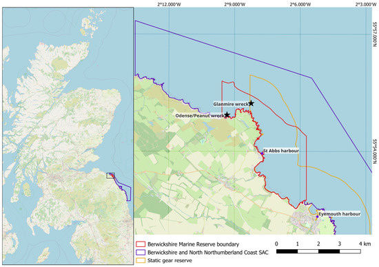
Figure 1.
Map of Scotland showing the boundaries of the Berwickshire Marine Reserve (BMR), Berwickshire and North Northumberland Coast (BNNC) Special Area of Conservation (SAC), and Static Gear Reserve (SGR), and locations of local harbours and two shipwrecks (black stars).
The BMR is Scotland’s first and only voluntary marine reserve and forms part of the Berwickshire and North Northumberland Coast (BNNC) Special Area of Conservation (SAC), included as a Nature Conservation (NC) Marine Protected Area (MPA) in the Scottish MPA network. Covering an area over 652 km2, it extends from Alnmouth in England up to Fast Castle head in Scotland. It was designated to protect several Annex I habitats and Annex II species as listed in the European Union Habitats Directive [12] (https://sitelink.nature.scot/site/8207 [accessed on 21 August 2025]).
The majority of the BMR overlaps with a Static Gear Reserve (SGR) where a prohibition of fishing order excludes mobile or active fishing gear, meaning the area is protected by law from bottom trawling [13]. The SGR covers 26 km2 and extends one nautical mile offshore from St Abbs Head in the north to the Scotland-England border in the south.
2.2. Data Collection
A combination of data sources was used to generate a map of horse mussel locations throughout the BMR. These included historical records from various sources, gathering information from the general public during recreational dives, and conducting dedicated dive and Remotely Operated Vehicle (ROV) surveys.
2.2.1. Historical Records
Historical records of horse mussels from Heriot-Watt University and St Abb’s Head National Trust for Scotland were used, along with those downloaded from iNaturalist [14], Joint Nature Conservation Committee [15], Porcupine Natural History Society [16], and Seasearch [11]. These included sightings that were part of dedicated biodiversity surveys and opportunistic sightings.
Data from Blue Marine Foundation [10,17] was also incorporated. These data were gathered during two survey programmes. Towed underwater video surveys to quantify sessile and sedentary benthic species, combined with Baited Remote Underwater Video (BRUV) surveys that quantified benthic associated mobile nekton species carried out throughout the Berwickshire designations in May 2021. In August 2021 and 2022 dedicated dive surveys were conducted in areas where the remote camera could not access. This included surveys on and around shipwrecks [10].
2.2.2. Posters
Due to the popularity of St Abbs as a recreational scuba diving location, a poster and survey form (online [18] and paper) were created for the public to report horse mussel sightings within the BMR. This was distributed prior to and during the 2023 diving season to local dive boats, clubs, shops, accommodation, notice boards, and social media.
2.2.3. Dive Surveys
Between 19 to 23 June 2023, 18 dive surveys were conducted in conjunction with Project Baseline divers as part of a Blue Marine Foundation project. Video recordings or pictures were taken of horse mussels, where possible. The majority of dives were conducted in and around the Glanmire wreck (55.92046667, −2.137366667). These included various individual transects and other search patterns (e.g., circular and crenulated). Targeted surveys on varying habitat types were conducted to account for the range in benthos throughout the BMR. A more thorough set of three transects were conducted southeast from the Glanmire wreck with video recorded for the entire transect lengths of ca. 150–300 m towards the Glanmire wreck. Short surveys were also carried out in Pettico Wick (55.916389, −2.154167). Additionally, the current possible bed location (55.914183, −2.12675) was searched with three 50 m transects, with video recordings taken continuously. GPS positions from these surveys were based on vessel positions.
2.2.4. ROV Transects
ROV surveys were conducted on 11 August and 27 September 2023 (Chasing M2, Chasing, Beijing, China), and 15 August 2024 (Chasing M2 Pro, Chasing, Beijing, China). Where possible, the ROV was moved away from the vessel at a constant rate of speed of ca. 0.5–1 m/s, and a maintained height of ca. 0.5 m above the seabed. The ROV was flown until the umbilical cable was taut. The transect distance depended on the depth of the seabed, with the ROV umbilical cable measuring 100 m.
In 2023 GPS coordinates of the ROV were approximated from the vessel’s location. In 2024 an ultra-short baseline (USBL) acoustic positioning system (Chasing USBL underwater locator kit, Chasing, Beijing, China and Cerulean ROV locator bundle Mark II, Cerulean Sonar, Wayzata, MN, USA) was used for more accurate positioning of horse mussel sightings.
2.3. Data Analysis
Video files from all sources were analysed using Behavioural Observation Research Interactive Software (BORIS, v. 8.22.15 2014-01-08), an open-source event logging software [19]. A sighting/event was logged for live horse mussels (both valves [halves of the shell] visible and closed or slightly open with animal visible [e.g., siphon]) or shells (separate valves or open wide). Within this event, the number of live mussels or shells, along with seabed type was recorded. Seabed types from Seasearch were used, as per Table 1. If there was no evidence of horse mussels in the video an event was logged with zero sightings of live mussels to record the last seen seabed type in the video. Data was analysed by at least two independent observers. Results were cross referenced to confirm consistency in methodology and account for any discrepancies.

Table 1.
Seabed type categories used, as per Seasearch observation forms (www.seasearch.org.uk [accessed on 21 August 2025]).
Where possible, horse mussel sightings were plotted along transects using QGIS Desktop 3.42.2 [20]. Sightings from historical records, habitat type, survey locations, and shipwreck locations were also mapped.
As it was often not possible to recorded specific locations of individual horse mussel sightings, locations were approximated. For videos of full transects, an approximate overall speed was calculated using the distance covered by the transect and the time to complete the transect. Sightings on the transect (i.e., distance from starting coordinates) were calculated by dividing speed by the time stamp of the event recorded. Using the ‘GeographicLib’ package in R [21] (R Studio 2023.9.1.494, R version 4.5.1), these points were assigned GPS coordinates by calculating change in latitude and longitude based on bearing and distance moved. Due to inconsistencies in the collection of some video transects, not all points (horse mussel sightings) were plotted along transects and were therefore displayed as total number of animals at the starting coordinate or evenly spaced along the approximate survey transect.
Locations of horse mussel sightings from ROV surveys in 2024 were taken from the USBL position system.
After plotting sightings, heatmaps were created in QGIS to highlight any possible areas which may meet PMF requirements for semi-infaunal horse mussels of at least five live individuals per m2. Survey techniques did not allow for an accurate calculation of percentage cover, therefore only the general likelihood is mentioned. Assuming a field of view of 2 m on average, 12.5 m lengths surrounding the 1 m PMF section were assessed visually for percentage cover in a 25 m2 area. PMFs were then assigned a biotope as per the Joint Nature Conservation Committee (JNCC) marine habitat classification for Britain and Ireland [22,23].
Data were submitted to NatureScot for entry into Marine Recorder, which will then also be available in the Geodatabase of Marine features adjacent to Scotland (GeMS). A metadata record for the survey will be created for the Marine Environmental Data and Information Network (MEDIN) portal and data available in the UK MEDIN Data Archive Centre (DAC) network for marine species and habitats data (DASSH). Transect summaries and location details for all sightings were uploaded to Mendeley Data for public access.
3. Results
3.1. Historical Records
A total of 40 historical horse mussel sighting records were mapped, 31 sightings between 1979 and 2014 (over 10 years ago) and nine between 2019 and 2022. Many details were not recorded during these sightings, for example, specifying whether sightings were of live horse mussels or shells and how many individuals were seen.
3.2. Contemporary Survey Data
During the study survey period (2023 and 2024) a total of 217 live horse mussels and 663 shell sightings were mapped (Figure 2). Five public sightings were recorded from recreational divers and a fisherman. Public sightings included at least six live horse mussels and anywhere from two to ‘lots’ of shells.
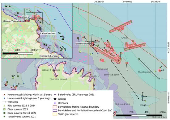
Figure 2.
Chart showing historical and study specific survey locations, transects, and live horse mussel (Modiolus modiolus) sightings within the Berwickshire Marine Reserve (BMR), Scotland. High level habitat classifications from Blue Marine Foundation surveys are labelled and coloured, areas that have not been surveyed are shown in blue without a label.
Project Baseline completed 20 dive surveys in June 2023 covering at least 190 m of seabed. Length details for some transects were missing, therefore this is a low estimate. A total of 192 live horse mussels were mapped from 177 sightings recorded from videos and pictures (Figure 3). Not all sightings were filmed; therefore, this is likely a low estimate. One dive towards the Glanmire wreck saw individuals all along the drift. At least 363 dead shells were also noted from all dives, with additional dives only mentioning that shells were seen. Live sightings with location data were on cobbles and pebbles (n = 92), sand and gravel (n = 61), a mix of sand and gravel and cobbles and pebbles (n = 5), and mixed ground (n = 13). No horse mussels were seen at the possible bed location held by NatureScot.
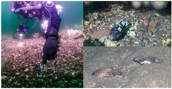
Figure 3.
Examples of horse mussel (Modiolus modiolus) sightings in the Berwickshire Marine Reserve (BMR). Left: Diver pointing to a live horse mussel at the Glanmire wreck on cobbles and pebbles. Top right: Live horse mussel seen in Pettico Wick on cobbles and pebbles. Bottom right: Horse mussel shells seen south of the Glanmire wreck on a sandy seabed.
Five ROV transects were completed in August and September 2023 with boat associated location data and four ROV transects in August 2024 with ROV USBL location data. Approximately 765 m of seabed was surveyed. A total of 42 live horse mussels were recorded and mapped from ROV surveys, mostly on a sand and gravel seabed (n = 39). An additional 397 shells from 348 sightings were recorded. Two ROV transects in particular had shells evenly spaced along the entire transect, seen around at least every 10 s.
3.3. Spatial Distribution and PMF Identification
Overall, mainly individuals were recorded (n = 202). Small clumps of 2–5 horse mussels were also recorded (n = 14).
Five locations (Figure 4) were highlighted that may meet PMF requirements of at least five live individuals in 1 m2 (Table 2). Four of these locations may also have 30% cover over a 25 m2 area. Details and accuracy of estimated positions for these locations varied. Divers gave details of ‘tons of individuals in clusters, saw so many at drop down of the shot line’, but there was not continuous video footage to get a recorded number. The boat location at the start of this dive (transect 7) was southeast of the Glanmire wreck. Two other dive transects (transect 18 and 20) that started in a similar location have three possible 1 m2 areas of five or more live horse mussels, two of which are more likely to meet the 30% cover requirement. Locations of these sightings were based on the straight distances covered by the dive boat and the length of the video files; therefore, locations are very approximate. The ROV survey east of the Glanmire near the edge of the BMR had one 1 m2 area of six live horse mussels and seven shells, and likely has 30% cover (transect 26).
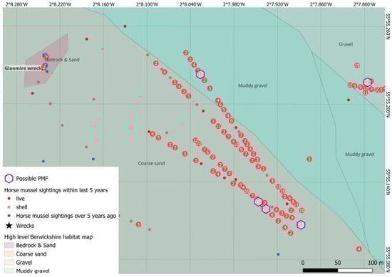
Figure 4.
Chart showing locations of live horse mussels (Modiolus modiolus) and horse mussel shells within the Berwickshire Marine Reserve (BMR), Scotland, along with possible Priority Marine Feature (PMF) semi-infaunal horse mussel beds.
Table 2.
Details of possible horse mussel (Modiolus modiolus) Priority Marine Features (PMFs) from surveys conducted in the Berwickshire Marine Reserve (BMR). These are locations where five or more live horse mussels were seen within one meter. Percent cover could not be calculated accurately, therefore only the possibility is mentioned. Biotopes are as per national Joint Nature Conservation Committee (JNCC) marine habitat classification for Britain and Ireland. SS.SBR.SMus.ModMx = Modiolus modiolus beds on open coast circalittoral mixed sediment and SS.Smx.IMx = infralittoral mixed sediment.
3.4. Other Species
Other species were not recorded specifically as part of these surveys, but examples include fish (haddock [Melanogrammus aeglefinus], European plaice [Pleuronectes platessa], common dab [Limanda limanda] and other flatfish), decapods (edible [Cancer pagurus], harbour [Liocarcinus depurator], and hermit crabs [Pagurus bernhardus], squat lobsters [e.g., Munida rugosa]), bivalves (cockles, razor clam, scallop [Aequipecten opercularis]), jelly fish (blue [Cyanea lamarckii], moon, comb), anemones (Dahlia [Urticina felina]), soft corals (dead man’s fingers [Alcyonium digitatum]), echinoderms (edible urchin [Echinus esculentus] and common starfish [Asterias rubens]), and polychaetes (spirorbis worms).
4. Discussion
This study adds valuable evidence of horse mussels in the voluntary BMR and supplements other databases of horse mussels throughout the UK and North Sea.
Horse mussels were observed at various locations throughout the BMR. Sightings came from five public sightings, 20 dive surveys and nine ROV surveys. A total of 217 live horse mussels and over 600 shells were recorded. Sightings mainly consisted of individual horse mussels with sporadic clumps also recorded. Five locations were found to meet the minimum requirement of five live horse mussels in 1 m2 for a semi-infaunal PMF. Four of these locations were also likely to meet the minimum 30% cover over a 25 m2 area. This provides some verification for the record held by NatureScot for the Berwickshire coast of Scotland [24], which has no associated details [4].
4.1. Local and Regional Importance
Even with the relatively sparse distribution of horse mussels found during this study, it is believed that for conservation and management, frequent smaller clumps may also be important [3]. Horse mussel beds in Strangford Lough and on the west coast of Scotland with only 10% seabed cover are nevertheless host to diverse biotic assemblages, likely still contributing to ecosystem functioning [2].
The presence of horse mussels in the BMR may also increase connectivity between other established horse mussel populations [25,26,27], yet this currently requires further investigation [28].
4.2. Habitat Suitability
To aid future consultations and possible changes to management, it is important to understand whether the habitat within the BMR is suitable for the expansion of horse mussels, or whether the habitat may be a limiting factor. Overall, horse mussels are found in a wide range of biotopes [27]. A habitat model found the following parameters were best at predicting suitable habitat, in order of importance: minimum salinity at seabed, current energy at seabed, mean temperature at seabed, depth, wave energy at seabed, slope, and substrate [29]. The BMR, for example, has suitable salinity, mixed course sediments, reasonable tidal currents, and restrictions on mobile fishing gear.
4.2.1. Salinity
Horse mussels are known to be sensitive to salinity changes, with their optimum range 30–35 ppt [8,30]. Whilst salinity was not recorded as part of this study, it is regularly recorded within the BMR by Marine Scotland in St Abbs at a shallow subtidal location (2017–2020: mean 34.205 ppt, min 33.618, max 34.687) [31] and by St Abbs Marine Station intertidally (2017–2023: mean 34.015 ppt, min 30.04, max 35.5), which fall within the optimum range.
4.2.2. Current and Wave Energy
Current speeds have been shown to be an important variable when modelling horse mussel distribution [29]. Whilst an earlier environmental envelope analysis resulted in a preferred range of 0.5–1.115 m/s for average spring current speeds [8], more recent models have found there is not a specific preferred range [29].
Whilst not specifically measured or modelled for the BMR, wave and current models available from EMODnet (www.emodnet-seabedhabitats.eu [accessed on 17 April 2025]) indicate the kinetic energy at the seabed within the BMR should be around 3–84 N.m2/s due to waves and 50–133 N.m2 due to currents. On a coarser scale, Marine Scotland (https://marinescotland.atkinsgeospatial.com/nmpi/ [accessed on 17 April 2025]) has an annual mean wave power of approximately 6 kW/m (https://marine.gov.scot/node/12666 [accessed on 17 April 2025]) and, using a wave fetch model, has a wave exposure index of around 4 (https://marine.gov.scot/node/12833 [accessed on 17 April 2025]). Maximum kinetic energy at the seabed modelled by EMODnet for known Scottish horse mussel beds is around 0.1–2500 N.m2/s due to waves and 0.5–2400 N.m2 due to currents. Wave exposure index varied around 1.7–4.3. All overlapping with ranges in the BMR. The annual mean wave power was only available for two Scottish horse mussel beds, modelled around 18–24, which is higher than modelled in the BMR.
4.2.3. Temperature
Horse mussels generally populate colder waters, with their southern distribution limit likely being related to temperature [27]. At the other end, whilst horse mussels do not appear to have a minimum temperature limit with regards to adult distribution [27], spawning is thought to have a narrow temperature window (7–10 °C), which could affect more northerly populations [32]. ROV surveys conducted in the middle of August 2024 recorded seabed temperatures of ca. 11 °C, and ca. 13.5–14 °C in September 2023. Long term temperature monitoring within the BMR is mainly intertidal or in shallow water only, therefore, to understand the potential success of spawning within the BMR spat collection and further environmental monitoring is required. St Abbs has warmer waters coming from the south and colder waters coming from the north, therefore it may be ideally placed to allow for connectivity between warmer and colder water populations [25]. This may serve as a source of temperature resilient and adaptive larvae, which could aid in offsetting some shifts in temperature [25].
4.2.4. Depth and Slope
Horse mussels are a mainly subtidal species which have been found as deep as 280 m; however, beds are often restricted to 5 to 50 m in UK waters [27], with a preferred range of 0 to 20 m depth and 0 to 0.345% slope [8]. Sightings during this study were found at depths of 25–56 m, with the BMR going down to depths of around 70 m.
4.2.5. Substrate
Horse mussels are found on a variety of substrata, most often on muddy gravel through to cobbles and bedrock [3,6,33]. Using Seasearch seabed types, during this study horse mussels were seen on cobbles and pebbles, mixed ground, and sand and gravel. A high-resolution geophysical and ground truth sampling survey conducted in 2018 and 2019 provided a detailed benthic habitat map for Berwickshire. Seafloor conditions ranged between coarse sands and gravel, rocky reefs, cobbles and boulders, medium coarse sands and ripples and fine to medium sands [34]. The looser substrata may improve recruitment, as inaccessible byssus threads of adult horse mussels in sediment may provide larvae protection from predation [27].
Wrecks have also been shown to play an important role for horse mussels [35]. Dive surveys conducted in 2021 and 2022 off the Berwickshire coast included two shipwrecks within the BMR, the Glanmire and Odense, where 34 horse mussel individuals were recorded, along with profuse shell cultches, although few horse mussels were seen directly on the shipwrecks [10]. The physical presence of shipwrecks is discussed further below, in relation to protection from fishing pressure.
4.2.6. Turbidity and Sedimentation
Horse mussels are found in a range of turbid and clear water conditions [27]. Generally, the east of Scotland has relatively low suspended particulate matter [36] and low suspended particulate inorganic matter within the BMR [37]. As only static fishing gear is permitted within the reserve there should not be any significant sediment disturbance from fisheries activity. Even with reports of illegal trawling in 2019, the proportion of overall sedimentation from infrequent trawling is likely to be relatively low [38]. Sedimentation from other anthropogenic activities such as windfarm construction and operation, and harbour works are unlikely to significantly impact horse mussels in the BMR due to their distance (e.g., nearest windfarm 30 km away) and short-lived nature of effects [39,40,41].
4.2.7. Predators
Due to their small size young horse mussels are vulnerable to predation by crabs and starfish [33,42]. Velvet crabs (Necora puber), edible crabs, and common starfish have all been seen during this study, or within the BMR during other surveys (e.g., [11,43]). Future studies could look more closely at this relationship to understand whether it is a limiting factor to the establishment of a horse mussel bed within the BMR.
4.2.8. Pollution
As filter feeders, horse mussels may accumulate pollutants present in the water [44]. The most likely source of pollution within the BMR is agricultural runoff and sewage overflows. The Scottish Environment Protection Agency (SEPA) advises against bathing at Coldingham Bay and Eyemouth for two days after heavy rain [45]. As horse mussels have the potential to act as a benthic indicator species, sampling some resident mussels may give insight into their exposure to pollutants, both current and historical [44,46].
4.2.9. Fishing Pressure
The greatest threat to horse mussel beds is bottom-towed fishing gear, which causes the destruction, and in some cases elimination, of beds due to extensive physical impacts [3,47]. In theory, the majority of the BMR should be protected, however, enforcement of fishing regulations and conservation measures in Scotland has been inconsistent, leading to violations and illegal fishing practices [48]. There have been reports and evidence of illegal incursions in the SGR in 2019 [49], and fishing vessels were given a fixed penalty notice from Marine Scotland between June to December 2021 [50]. Anecdotal evidence (stakeholder workshops, fishermen perspective interviews, and towed video footage [17]) suggest that there have been annual incidents of dredge fishing within the SGR, although this is unverified.
Automatic Identification System (AIS) data from Global Fishing Watch (GWF, https://globalfishingwatch.org/ [accessed on 25 March 2025]) and MarineTraffic (www.marinetraffic.com [accessed on 25 March 2025]) has been explored in order to gain some understanding of possible fishing effort in the BMR. Evidence of vessel effort tracks were recorded during the 2019 incursion into the SGR (Figure 5). This suggested the vessels may have actively avoided the Glanmire wreck, likely avoiding the increased risk of gear entanglement. This avoided area happened to be where the majority of this study’s survey effort and sightings occurred. Future studies could look to survey in more northly locations to examine the possible difference of horse mussels in untrawled and trawled areas within the SGR.
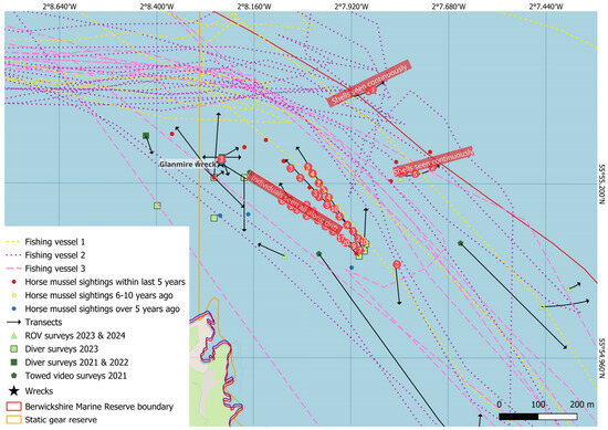
Figure 5.
Automatic Identification System (AIS) based trawling fishing vessel tracks from MarineTraffic (www.marinetraffic.com [accessed on 25 March 2025]) during the 2019 incursion in the Static Gear Reserve (SGR) off the Berwickshire coast, UK, overlaid on horse mussel (Modiolus modiolus) sightings and survey locations.
The main fishery within the BMR is lobster and crab potting. The extent of damage from potting on horse mussels is unknown. While damage may be possible for semi-infaunal reefs [27], static gear should have comparatively little impact on horse mussel beds [3]. There will however be a threshold for a sustainable fishery [51]. No pots were observed specifically within the main survey area southeast of the Glanmire, with most pots being placed closer to shore (Figure 2 in [52]).
4.3. Future Monitoring and Management Measures
In practice the methodology employed in this study proved effective at gaining more information about horse mussels within the BMR by combining data from various sources. It will only be through further surveys that more information can be gained on the extent of horse mussels within the BMR and how their distribution and numbers might change. With models showing a major decline in ideal horse mussel habitats in the coming decades [8,53], the long-term monitoring of horse mussels within the BMR may be important for understanding the potential change in the wider horse mussel population and help inform their protection. Future monitoring should include investigations into the change to the overall extent of the horse mussel population and possible discrete patches or isolated clumps, recruitment (aging and spat collectors), predation and associated fauna. Survey methods with greater statistical power, such as those with quadrats, should be employed [2], along with hydrodynamic and habitat suitability modelling [54].
Within the area there may also be scope for a unique case study to contribute to filling knowledge gaps surrounding the potential effects from static fishing gear on horse mussels. In terms of horse mussel PMFs and towed fishing the Berwickshire and North Northumberland Coast SAC is considered to already be well managed [55], however, since then, the Government has identified the need to consult on further protection measures for MPAs and PMFs [56]. This preliminary survey will be able to contribute to these consulations, and also highlights the need to gain a better understanding of horse mussels in the area to more adequately inform future consultations.
5. Conclusions
Recreational and trained volunteer divers along with ROV surveys improved the knowledge base of horse mussel presence within the BMR. Possible locations of Scottish PMFs were identified from this study. Even with small numbers, horse mussels within the BMR may still be valuable for ecosystem functioning and will contribute to future consultations. The habitat within the BMR appears to be relatively suitable for the further expansion of horse mussels. Additional monitoring will allow for a better understanding of horse mussel distribution and PMF extent within the area. A clearer picture of fishing effort and possible impacts is required to aid any potential future management measures.
Author Contributions
Conceptualization, E.C.N.C., J.R. and A.H.; methodology, E.C.N.C., F.J.A.H., A.H. and J.R.; validation, E.C.N.C.; formal analysis, E.C.N.C.; investigation, E.C.N.C., F.J.A.H., R.G., K.I. and C.K.; resources E.C.N.C., F.J.A.H. and J.R.; data curation, E.C.N.C., F.J.A.H. and J.R.; writing—original draft preparation, E.C.N.C., F.J.A.H. and J.R.; writing—review and editing, R.G., A.H., K.I. and C.K.; visualization, E.C.N.C.; supervision, E.C.N.C. and J.R.; project administration, E.C.N.C., A.H., C.K. and J.R.; funding acquisition, E.C.N.C., A.H. and J.R. All authors have read and agreed to the published version of the manuscript.
Funding
This research was supported by the Scottish Marine Environmental Enhancement Fund (SMEEF) and by Scottish Government’s Nature Restoration Fund, which is facilitated by SMEEF, and managed by NatureScot. Project reference number 502268—SMEEF 2023.
Data Availability Statement
Data are available on Mendeley Data at https://data.mendeley.com/datasets/jypsd478f6/2 [57] and on Marine Recorder Online (https://www.marine-recorder.org.uk/ [accessed on 21 August 2025]).
Acknowledgments
We thank Project Baseline for conducting the dive surveys. Phil Rutherford (Silver Sea), St Abbs Charters, Marine Quest and Aquamarine Charters for boat hire and/or reporting their diver’s sightings. Dive boat operators, dive shops, snorkelling groups and local accommodations who shared or displayed our poster. The staff at NatureScot for pre-survey and data advice. Seasearch for providing data. St Abbs Marine Station staff, Kevin Scott and Jonathan Wilkes, for assistance with the ROV. And St Abbs Marine Station volunteer Natalie Nosenko (QGIS) and Finlay Jardin (video analysis).
Conflicts of Interest
The authors declare no conflicts of interest.
Abbreviations
The following abbreviations are used in this manuscript:
| AIS | Automatic Identification System |
| BMR | Berwickshire Marine Reserve |
| BNNR | Berwickshire and North Northumberland Coast |
| BORIS | Behavioral Observation Research Interactive Software |
| BRUV | Baited Remote Underwater Video |
| DAC | Data Archive Cantre |
| GeMS | Geodatabase of Marine features adjacent to Scotland |
| GPS | Global Positioning System |
| HELCOM | Helsinki Commission/Baltic Marine Environment Protection Commission |
| JNCC | Joint Nature Conservation Committee |
| MEDIN | Marine Environmental Data and Information Network |
| MPA | Marine Protected Areas |
| NC | Nature Conservation |
| OSPAR | Oslo and Paris Convention for the Protection of the Marine Environment of the North-East Atlantic |
| PMF | Priority Marine Feature |
| ROV | Remotely Operated Vehicle |
| SAC | Special Area of Conservation |
| SGR | Static Gear Reserve |
| SMR | Scottish Marine Regions |
| UK | United Kingdom of Great Britain |
| UKBAP | United Kingdom Biodiversity Action Plan |
| USBL | Ultra-Short Baseline |
References
- Wilding, C.; Durkin, O.; Lacey, C.; Philpott, E.; Adams, L.; Chaniotis, P.D.; Wilkes, P.T.V.; Seeley, B.; Neilly, M.; Dargie, J.; et al. Descriptions of Scottish Priority Marine Features (PMFs); Scottish Natural Heritage Commissioned Report No 406; Tyler-Walters, H., James, B., Carruthers, M., Eds.; Scottish Natural Heritage: Inverness, UK, 2016. [Google Scholar]
- Fariñas-Franco, J.; Pearce, B.; Porter, J.; Harries, D.; Mair, J.; Woolmer, A.; Sanderson, W. Marine Strategy Framework Directive Indicators for Biogenic Reefs Formed by Modiolus modiolus, Mytilus edulis and Sabellaria spinulosa—Part 1: Defining and Validating the Indicators; JNCC Report No. 523; Joint Nature Conservation Committee: Peterborough, UK, 2014. [Google Scholar]
- OSPAR. Background Document for Modiolus Modiolus Beds; Biodiversity Series; OSPAR Commission: London, UK, 2009. [Google Scholar]
- Marine Scotland Priority Marine Feature (PMF)—Fisheries Management Review. 2019. Available online: https://consult.gov.scot/marine-scotland/priority-marine-features/supporting_documents/Review%20of%20PMFs%20outside%20the%20Scottish%20MPA%20network%20%20FINAL%20%20Horse%20mussel%20beds.pdf (accessed on 24 March 2023).
- Morris, E. Defining Annex I Biogenic Modiolus modiolus Reef Habitat Under the Habitats Directive: Report of an Inter-Agency Workshop March 4th & 5th, 2014; JNCC Report No. 531; Joint Nature Conservation Committee: Peterborough, UK, 2014; p. 531. [Google Scholar]
- Saunders, G.; Gubbay, S. European Red List of Habitats—Marine Habitat Group. A5.62: Mussel Beds Modiolus modiolus on Atlantic Sublittoral Sediment; European Environment Agency: Copenhagen, Denmark, 2016. [Google Scholar]
- Mazik, K.; Strong, J.; Little, S.; Bhatia, N.; Mander, L.; Barnard, S.; Elliott, M. A Review of the Recovery Potential and Influencing Factors of Relevance to the Management of Habitats and Species Within Marine Protected Areas Around Scotland; Scottish Natural Heritage Commissioned Report No 771; Scottish Natural Heritage: Perth, UK, 2015. [Google Scholar]
- Gormley, K.S.G.; Porter, J.S.; Bell, M.C.; Hull, A.D.; Sanderson, W.G. Predictive Habitat Modelling as a Tool to Assess the Change in Distribution and Extent of an OSPAR Priority Habitat under an Increased Ocean Temperature Scenario: Consequences for Marine Protected Area Networks and Management. PLoS ONE 2013, 8, 68263. [Google Scholar] [CrossRef]
- Moffat, C.; Baxter, J.; Berx, B.; Bosley, K.; Boulcott, P.; Cox, M.; Cruickshank, L.; Gillham, K.; Cox, A.; Haynes, V.; et al. Scotland’s Marine Assessment 2020; Scottish Government: Edinburgh, UK, 2020. [Google Scholar]
- Hickman, J.; Richards, J.; Rees, A.; Sheehan, E.V. Shipwrecks Act as de Facto Marine Protected Areas in Areas of Heavy Fishing Pressure. Mar. Ecol. 2023, 45, e12782. [Google Scholar] [CrossRef]
- GBIF.org (22 December 2022) GBIF Seasearch. Seasearch Marine Surveys in Scotland. Occurrence Dataset. Available online: https://doi.org/10.15468/0hyjxi (accessed on 22 December 2022).
- Natural England. EC Directive 92/43 on the Conservation of Natural Habitats and of Wild Fauna and Flora. Citation for Special Area of Conservation (SAC) Berwickshire and North Northumberland Coast UK0017072; Natural England: York, UK, 2005. [Google Scholar]
- Scottish Statutory Instruments. The Inshore Fishing (Prohibition of Fishing and Fishing Methods) (Scotland) Order 2004; The National Archives: Kew, Richmond, UK, 2004. [Google Scholar]
- GBIF.org (22 December 2022) GBIF iNaturalist. iNaturalist Research-Grade Observations. iNaturalist.Org. Occurrence Dataset. Available online: https://doi.org/10.15468/ab3s5x (accessed on 22 December 2022).
- GBIF.org (1 March 2023) GBIF Joint Nature Conservation Committee. Marine Nature Conservation Review (MNCR) and Associated Benthic Marine Data Held and Managed by JNCC. Occurrence Dataset. Available online: https://doi.org/10.15468/kcx3ca (accessed on 1 March 2023).
- GBIF.org (22 December 2022) GBIF Porcupine Marine Natural History Society. Porcupine Marine Natural History Society Dataset. Occurrence Dataset. Available online: https://doi.org/10.15468/pcmg9q (accessed on 22 December 2022).
- Rees, A.G.; Sheehan, E.V. Developing Ecological Long-Term Monitoring of the Berwickshire Marine Reserve and Surrounding Area. Report to Blue Marine Foundation from University of Plymouth; University of Plymouth: Plymouth, UK, 2022; Available online: https://www.bluemarinefoundation.com/wp-content/uploads/2025/08/Developing-ecological-long-term-monitoring-of-the-Berwickshire-Marine-Reserve-and-surrounding-area_March_2022.pdf (accessed on 22 August 2025).
- Chapman, E. Berwickshire Marine Reserve Horse Mussel Survey Form. Available online: https://forms.gle/Xpg65YEZrUz1YyHN8 (accessed on 19 August 2025).
- Friard, O.; Gamba, M. BORIS: A Free, Versatile Open-Source Event-Logging Software for Video/Audio Coding and Live Observations. Methods Ecol. Evol. 2016, 7, 1325–1330. [Google Scholar] [CrossRef]
- QGIS Development Team QGIS Geographic Information System; Open Source Geospatial Foundation: Grüt, Switzerland, 2021.
- Karney, C.F.F. Algorithms for Geodesics. J. Geod. 2013, 87, 43–55. [Google Scholar] [CrossRef]
- Connor, D.W.; Allen, J.H.; Golding, N.; Howell, K.L.; Lieberknecht, L.M.; Northen, K.O.; Reker, J.B. The Marine Habitat Classification for Britain and Ireland. Version 04.05; JNCC: Peterborough, UK, 2004. [Google Scholar]
- JNCC. The Marine Habitat Classification for Britain and Ireland Version 22.04; JNCC: Peterborough, UK, 2022. Available online: https://mhc.jncc.gov.uk/ (accessed on 1 May 2025).
- NatureScot. NatureScot GeMS PMF Horse Mussel Beds. Available online: https://opendata.nature.scot/datasets/snh::gems-scottish-priority-marine-features/explore?filters=eyJQTUYiOlsiSG9yc2UgbXVzc2VsIGJlZHMiXX0%3D&layer=0&location=55.910194%2C-2.125040%2C13.91 (accessed on 3 March 2025).
- Mackenzie, C.L.; Kent, F.E.A.; Baxter, J.M.; Gormley, K.S.G.; Cassidy, A.J.; Sanderson, W.G.; Porter, J.S. Genetic Connectivity and Diversity of a Protected, Habitat-Forming Species: Evidence Demonstrating the Need for Wider Environmental Protection and Integration of the Marine Protected Area Network. Front. Mar. Sci. 2022, 9, 772259. [Google Scholar] [CrossRef]
- Gormley, K.; Mackenzie, C.; Robins, P.; Coscia, I.; Cassidy, A.; James, J.; Hull, A.; Piertney, S.; Sanderson, W.; Porter, J. Connectivity and Dispersal Patterns of Protected Biogenic Reefs: Implications for the Conservation of Modiolus modiolus (L.) in the Irish Sea. PLoS ONE 2015, 10, e0143337. [Google Scholar] [CrossRef]
- Holt, T.J.; Rees, E.I.; Hawkins, S.J.; Seed, R. Biogenic Reefs (Volume IX). An Overview of Dynamic and Sensitivity Characteristics for Conservation Management of Marine SACs; Scottish Association for Marine Science (SAMS): Dunbeg, UK, 1998. [Google Scholar]
- Millar, H.; O’Hara Murray, R.; Gallego, A.; Gormley, K.; Kent, F. Connectivity of Selected Priority Marine Features within and Outwith the Scottish MPA Network; NatureScot Research Report 1048; NatureScot: Inverness, UK, 2019. [Google Scholar]
- Castle, L.; Pinder, J.; Lillis, H.; Manca, E. Using an Ensemble Modelling Approach to Predict Suitable Habitat for Zostera marina Beds, Modiolus modiolus Beds and Sabellaria spinulosa Reefs in UK Waters; JNCC Report No. 718; JNCC: Peterborough, UK, 2022. [Google Scholar]
- Bakhmet, I.N.; Komendantov, A.J.; Smurov, A.O. Effect of Salinity Change on Cardiac Activity in Hiatella arctica and Modiolus modiolus, in the White Sea. Polar Biol. 2012, 35, 143–148. [Google Scholar] [CrossRef]
- Marine Scotland Science. Scottish Coastal Observatory—St Abbs Site Data. Available online: https://data.marine.gov.scot/dataset/scottish-coastal-observatory-st-abbs-site (accessed on 18 December 2023).
- Brown, R.A. Geographical Variations in the Reproduction of the Horse Mussel, Modiolus modiolus (Mollusca: Bivalvia). J. Mar. Biol. Assoc. UK 1984, 64, 751–770. [Google Scholar] [CrossRef]
- Dinesen, G.E.; Morton, B. Review of the Functional Morphology, Biology and Perturbation Impacts on the Boreal, Habitat-Forming Horse Mussel Modiolus modiolus (Bivalvia: Mytilidae: Modiolinae). Mar. Biol. Res. 2014, 10, 845–870. [Google Scholar] [CrossRef]
- Bates, R. Geophysical Survey, St Abbs Head, 2018-2019; Report for Blue Marine Foundation; Earth & Environmental Sciences: St Andrews, UK, 2019. [Google Scholar]
- Sanderson, W.G.; Hirst, N.E.; Fariñas-Franco, J.M.; Grieve, R.C.; Mair, J.M.; Porter, J.S.; Stirling, D.A. North Cava Island and Karlsruhe Horse Mussel Bed Assessment; Scottish Natural Heritage Commissioned Report No 760; Scottish Natural Heritage: Aberdeen, UK, 2014. [Google Scholar]
- DEFRA Marine Online Assessment Tool. Sea Surface Suspended Sediments and Turbidity. United Kingdom Marine Monitoring & Assessment Strategy (UKMMAS). Available online: https://moat.cefas.co.uk/previous-assessments/2018-assessment/ocean-processes-and-climate/turbidity/ (accessed on 17 April 2025).
- Marine Scotland. Scotland’s Marine Assessment 2020: Suspended Particulate Inorganic Matter (Turbidity). Available online: https://marine.gov.scot/sma/assessment/suspended-particulate-inorganic-matter-turbidity (accessed on 17 April 2025).
- Strong, J.A.; Service, M. Historical Chronologies of Sedimentation and Heavy-Metal Contamination in Strangford Lough, Northern Ireland. Biol. Environ. 2008, 108, 109–126. [Google Scholar] [CrossRef]
- Hitchcock, D.R.; Bell, S. Physical Impacts of Marine Aggregate Dredging on Seabed Resources in Coastal Deposits. J. Coast. Res. 2004, 20, 101–114. [Google Scholar] [CrossRef]
- Vanhellemont, Q.; Ruddick, K. Turbid Wakes Associated with Offshore Wind Turbines Observed with Landsat 8. Remote Sens. Environ. 2014, 145, 105–115. [Google Scholar] [CrossRef]
- Lecordier, E.M.; Gernez, P.; Mazik, K.; York, K.; Forster, R.M. Quantification of Turbid Wakes in Offshore Wind Farms Using Satellite Remote Sensing. Sci. Total Environ. 2025, 967, 178814. [Google Scholar] [CrossRef]
- Anwar, N.A.; Richardson, C.A.; Seed, R. Age Determination, Growth Rate and Population Structure of the Horse Mussel Modiolus modiolus. J. Mar. Biol. Assoc. UK 1990, 70, 441–457. [Google Scholar] [CrossRef]
- Lui, D. Assessing the Biodiversity of Intertidal Region within BMR (St Abbs, Coldingham, Killiedraughts) for Spatial and Temporal Comparisons; University of Edinburgh: Eyemouth, Edinburgh, UK, 2022. [Google Scholar]
- Richardson, C.A.; Chenery, S.R.N.; Cook, J.M. Assessing the History of Trace Metal (Cu, Zn, Pb) Contamination in the North Sea through Laser Ablation—ICP-MS of Horse Mussel Modiolus modiolus Shells. Mar. Ecol. Prog. Ser. 2001, 211, 157–167. [Google Scholar] [CrossRef]
- SEPA. Bathing Water Profile—Coldingham; Scottish Environment Protection Agency (SEPA): Stirling, Scotland, 2024. [Google Scholar]
- Lysenko, L.; Sukhovskaya, I.; Kantserova, N.; Bakhmet, I. Integrative Biomarker Indices in a Benthic Indicator Species Modiolus modiolus (L.) under a Simulated Oil Spill. Integration processes in the Russian and international research domain: Experience and prospects. KnE Soc. Sci. 2022, 7, 83–92. [Google Scholar] [CrossRef]
- Strong, J.A.; Service, M.; Moore, H. Estimating the Historical Distribution, Abundance and Ecological Contribution of Modiolus modiolus in Strangford Lough, Northern Ireland. Biol. Environ. 2016, 116B, 1. [Google Scholar] [CrossRef]
- Harrison, J. The Enforcement of Fishing Restrictions in Marine Protected Areas; Saving Our Seas through Law Policy Brief Series. Briefing No. 2; The University of Edinburgh, Edinburgh Law School: Edinburgh, UK, 2019. [Google Scholar]
- Williams, M. Anger at Justice “fails” over the Protection of Scotland’s Waters from “Rogue” Fishermen. The Herald. 12 December 2021. Available online: https://www.heraldscotland.com/news/homenews/19778225.anger-justice-fails-protection-scotlands-waters-rogue-fishermen/ (accessed on 8 May 2025).
- Marine Scotland. Marine and Fisheries Compliance: List of Fixed Penalty Notices; Scottish Government Marine Directorate: Edinburgh, UK, 2025. Available online: https://www.gov.scot/publications/marine-scotland-list-of-fixed-penalty-notices/ (accessed on 8 May 2025).
- Rees, A.; Sheehan, E.V.; Attrill, M.J. Optimal Fishing Effort Benefits Fisheries and Conservation. Sci. Rep. 2021, 11, 3784. [Google Scholar] [CrossRef]
- Easton, B.A.A.; Scott, K.; Richards, J.; Rees, A. Catch per Unit Effort of Decapod Species, C. pagurus and H. gammarus, from a Voluntary Marine Reserve. Fishes 2023, 8, 390. [Google Scholar] [CrossRef]
- Hiscock, K.; Southward, A.; Tittley, I.; Hawkins, S. Effects of Changing Temperature on Benthic Marine Life in Britain and Ireland. Aquat. Conserv. 2004, 14, 333–362. [Google Scholar] [CrossRef]
- Elsäßer, B.; Fariñas-Franco, J.M.; Wilson, D.; Kregting, L.; Roberts, D. Identifying Optimal Sites for Natural Recovery and Restoration of Impacted Biogenic Habitats in a Special Area of Conservation Using Hydrodynamic and Habitat Suitability Modelling. J. Sea Res. 2013, 77, 11–21. [Google Scholar] [CrossRef]
- Marine Scotland. 2014 Consultation on the Management of Inshore Special Areas of Conservation and Marine Protected Areas; Scottish Government: Edinburgh, UK, 2014. [Google Scholar]
- The Scottish Government. Programme for Government 2024–25: Serving Scotland; The Scottish Government: Edinburgh, UK, 2024. [Google Scholar]
- Chapman, E.; Hamilton, F.; Greatorex, R.; Higgs, A.; Innamorato, K.; Keeley, C.; Richards, J. Berwickshire Marine Reserve 2023-2024 Horse Mussel (Modiolus modiolus) Data with Survey Details, Summary Data, and Location Data. V2. Mendeley Data 2025. [Google Scholar] [CrossRef]


Disclaimer/Publisher’s Note: The statements, opinions and data contained in all publications are solely those of the individual author(s) and contributor(s) and not of MDPI and/or the editor(s). MDPI and/or the editor(s) disclaim responsibility for any injury to people or property resulting from any ideas, methods, instructions or products referred to in the content. |
© 2025 by the authors. Licensee MDPI, Basel, Switzerland. This article is an open access article distributed under the terms and conditions of the Creative Commons Attribution (CC BY) license (https://creativecommons.org/licenses/by/4.0/).