Article

Contrastive Analysis of Deep-Water Sedimentary Architectures in Central West African Passive Margin Basins During Late-Stage Continental Drift

1
College of Geosciences, China University of Petroleum, Beijing 102249, China
2
State Key Laboratory of Petroleum Resources and Prospecting, China University of Petroleum, Beijing 102249, China
3
School of Highway and Construction Engineering, Yunnan Communications Vocational and Technical College, Kunming 650500, China
4
Petroleum Exploration and Production Research Institute, SINOPEC, Beijing 100083, China
*
Authors to whom correspondence should be addressed.
J. Mar. Sci. Eng. 2025, 13(8), 1533; https://doi.org/10.3390/jmse13081533
Submission received: 4 July 2025 / Revised: 31 July 2025 / Accepted: 6 August 2025 / Published: 10 August 2025

Abstract

The Lower Congo Basin (LCB) and the Niger Delta Basin (NDB), two end-member deep-water systems along the West African passive margin, exhibit contrasting sedimentary architectures despite shared geodynamic settings. The research comprehensively utilizes seismic reflection structure, root mean square amplitude slices, drilling lithology, changes in logging curves, and previous research achievements to elucidate the controlling mechanisms behind these differences. Key findings include: (1) Stark depositional contrast: Since the Eocene, the LCB developed retrogradational narrow-shelf systems dominated by erosional channels and terminal lobes, whereas the NDB formed progradational broad-shelf complexes with fan lobes and delta-fed turbidites. (2) Primary controls: Diapir-driven topographic features and basement uplift govern architectural variability, whereas shelf-slope break configuration and oceanic relief constitute subordinate controls. (3) Novel mechanism: First quantification of how diapir-induced seafloor relief redirects sediment pathways and amplifies facies heterogeneity. These insights establish a tectono-sedimentary framework for predicting deep-water reservoirs in diapir-affected passive margins, refine the conventional “source-to-sink” model by emphasizing salt-geomorphic features coupling as the primary driver. By analyzing the differences in lithofacies assemblages and sedimentary configurations among the above-mentioned different basins, this study can provide beneficial insights for the research on related deep-water turbidity current systems and also offer guidance for deep-water oil and gas exploration and development in the West African region and other similar areas.

1. Introduction

Since Reading and Richards [1] proposed a classification of turbidite systems in deep-water basin margins, a comprehensive understanding has been achieved internationally regarding the deep-water sedimentary characteristics, the composition of architectural elements, and the hydrocarbon accumulation patterns in passive continental margin settings [2,3,4]. Wang et al. [5] identified various sedimentary units within deep-water turbidite systems of passive continental margins, considering sea-level changes as a primary factor influencing the development of these units. Zhao et al. [6] studied the composition of deep-sea turbidite fan lobe complexes in the Niger Delta. Li et al. [7] analyzed the structure of large-scale erosional channels in the Lower Congo Basin, suggesting that tectonic uplift, sea-level fluctuations, and climate change collectively control the development of deep-water channel complexes [5]. Deep-water turbidites on continental margins, as sedimentary systems driven by multiple factors, provide valuable insights into the formation, texture, and evolution of sediments within deep-water turbidites [8,9]. With the continuous accumulation of global deep-sea drilling and 3D seismic data, geologists have increasingly recognized the significant differences among deep-water turbidite systems formed in various sedimentary settings and tectonic regions [10], especially in passive continental margin areas with substantial variations in tilting styles, paleocurrent supply, paleogeomorphological changes, and shelf-slope types [11,12]. Therefore, in-depth analysis of deep-water sedimentation under multi-factor control, detailed examination of typical deep-water turbidite architectural elements, and comparison of diversified shelf-edge structural styles and morphological parameters are crucial foundations for further understanding of these sedimentary systems.
This study focuses on deep-water depositional systems within the Lower Congo Basin and Niger Delta Basin—passive margin petroleum basins in central West Africa. By integrating high-resolution seismic data, well logs, and previous research findings, we conduct qualitative and quantitative analyses to compare architectural elements of deep-water deposits. The aim is to reveal the characteristics of different sedimentary architectures in terms of basin geometry, internal structure, geological evolution, and sand bodies distribution. Furthermore, we elucidate the dominant controlling factors governing these architectural variations, providing guidance for deep-water hydrocarbon exploration and development in West Africa and analogous regions worldwide.

2. Regional Geological Overview

The basins on both sides of the South Atlantic are typical passive continental margin basins, resulting from the rifting of the African and South American plates of West Gondwana since the Late Jurassic [8,13]. These basins exhibit characteristics of segmented strike, transverse zoning, vertical layering, differential separation, and conjugate development [8,13,14,15]. The passive continental margin basins on the West African side of the South Atlantic (Figure 1) have undergone four evolutionary stages: cratonic, rift, transitional (sag), and continental drift [16]. They are divided into southern, central, and equatorial (including the Niger Delta) segments. The rift stage of the central segment basins (including Gabon and Lower Congo) occurred earlier than that of the equatorial segment basins, with widespread Aptian salt formations [17]. The Niger Delta Basin (Figure 1b) differs from other basins, representing a large-scale delta system that has been developing since the Cenozoic, lacking salt formations [18]. The equatorial segment basins (Côte d’Ivoire and Benin) are controlled by the Equatorial Atlantic transform fault, without salt development. Due to the gradual northward separation of Gondwana, the Lower Congo Basin formed earlier than the Niger Delta Basin, leading to differences in structural characteristics and stratigraphic infilling between the two basins [12] (Figure 1d,e).

2.1. Tectonic Evolution and Basin Structure

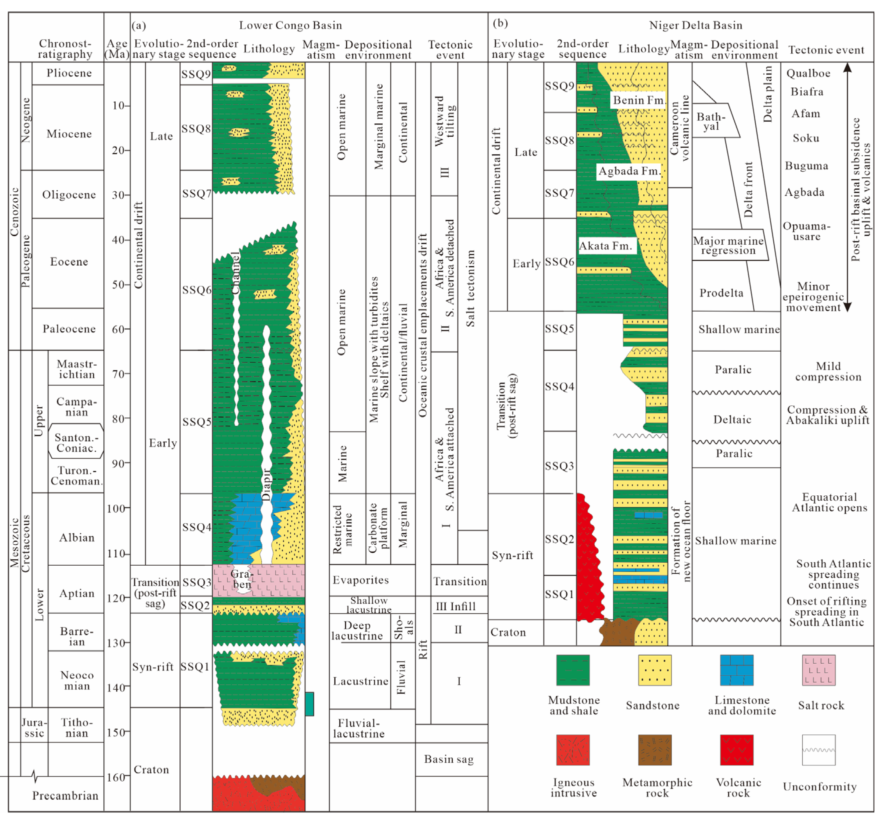
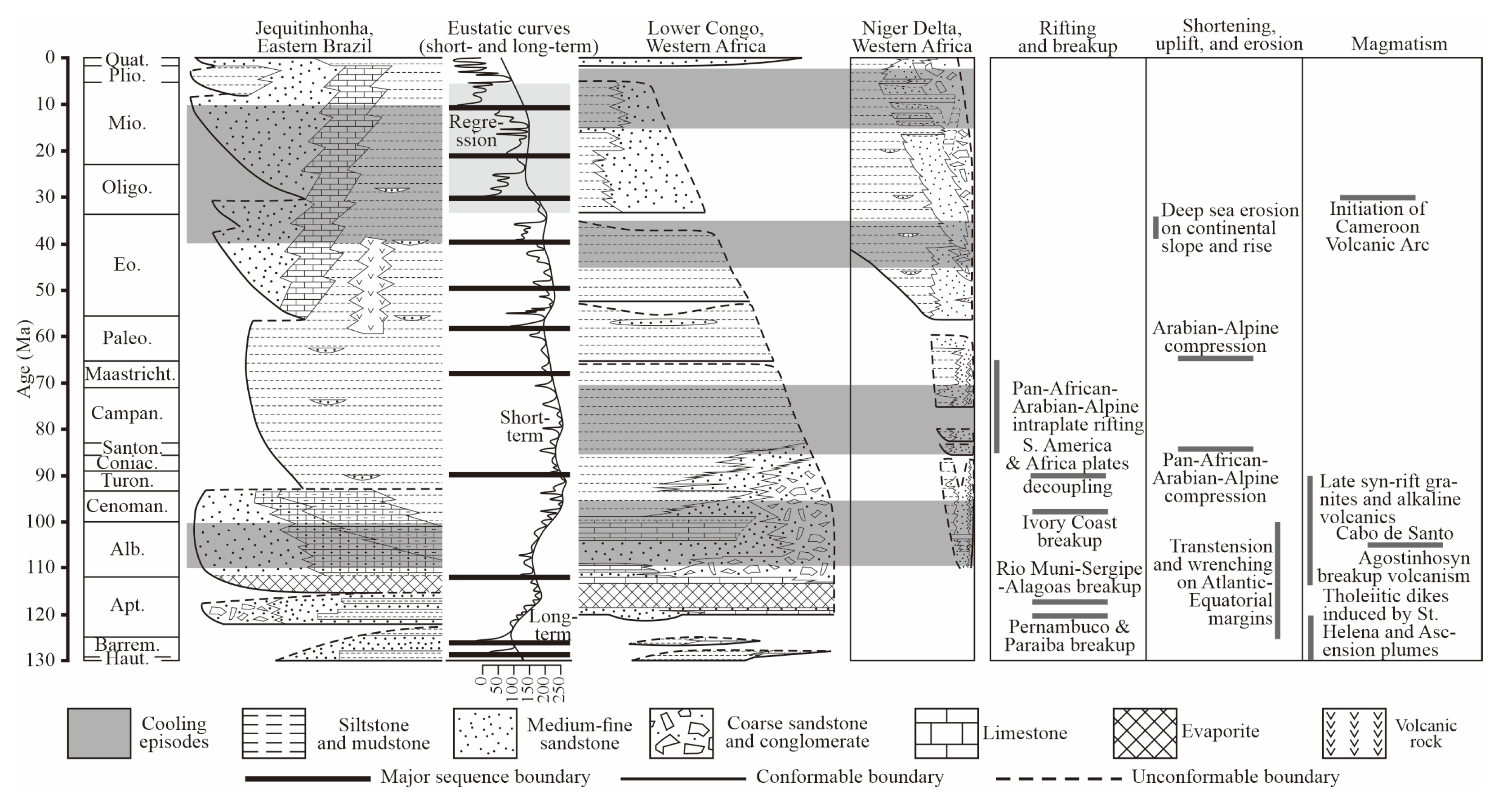
The formation of both basins is closely related to the breakup of Gondwana. The Lower Congo Basin is a result of the separation of the African and South American plates, beginning in the Late Jurassic Tithonian stage and undergoing cratonic, rift, transitional (sag), and continental drift stages [19] (Figure 1d and Figure 2a). The Niger Delta Basin was formed from the failed arm of a triple junction rift system in Nigeria, West Africa [20], developing since the Early Cretaceous Barremian stage and experiencing rift, transitional (sag), and continental drift stages [21] (Figure 1e and Figure 2b).
The Lower Congo Basin is located in central West Africa, covering a total area of approximately 170,000 km2, with most (89%) located offshore. It is a typical West African passive continental margin basin [21,22]. The tectonic deformation and structural styles of the basin exhibit clear zonation in plan view, divided from east to west into a thin-skinned extension zone, a salt diapir transition zone, and a frontal thrust-fold zone [23]. The main body of the deep-sea fan is developed within the thrust-fold zone (Figure 1d).
The Niger Delta Basin is located in the Gulf of Guinea in the equatorial Atlantic, with a total area of approximately 210,000 km2, with 62% located offshore. The basin originated in the Cretaceous and is mainly composed of Cenozoic deltas extending southwestward, with a sedimentary thickness exceeding 12 km [24]. Marine shales dominate the basin, with shale depositional activity significantly impacting hydrocarbon accumulation. Similar to the Lower Congo Basin, the tectonic features and structural styles of the Niger Delta Basin exhibit a typical tripartite zonation in plan view, divided from northeast to southwest into a thin-skinned extension zone, a mud diapir transition zone, and a thrust-fold zone (Figure 1e).

2.2. Stratigraphic Framework and Sedimentary Characteristics

The basement of the Lower Congo Basin is composed of Precambrian crystalline basement, overlain by Cretaceous to Neogene sedimentary strata, with local Jurassic formations. Aptian salt has a significant impact on the tectonics, sedimentation, and hydrocarbon accumulation of the basin [25]. Bounded by the salt layer, the basin’s strata are divided into pre-salt, salt, and post-salt sequences, corresponding to the rift, transitional (sag), and drift stages, respectively [26]. The pre-salt strata include fluvial-lacustrine sandstones and shales of the Late Jurassic Tithonian to Early Cretaceous Barremian stages (SSQ1). The salt layer contains shallow lacustrine sandstones, mudstones, and evaporitic rocks deposited during the Aptian stage (SSQ2–SSQ3) of the transitional (sag) phase. The post-salt strata include the Early Cretaceous Albian to Quaternary stages (SSQ4–SSQ9), with Albian deposits comprising restricted marine carbonates, transitioning upward into marine clastic sediments. The deep-sea fan systems are mainly developed in strata since the Late Cretaceous (Figure 2a).
The basement of the Niger Delta Basin is similar to that of the Lower Congo Basin, overlain by transgressive sedimentary strata of the Early Cretaceous Aptian to Albian rift stages (SSQ1–SSQ2), extending upward to the transitional (sag) phase. The Late Cretaceous Turonian to Paleocene (SSQ3–SSQ5, transitional phase) represents a large-scale transgressive stage, with deposits of alternating terrestrial-marine and shallow-marine to semi-deep-marine facies. From the Eocene to the present (SSQ6–SSQ9, continental drift phase), a large-scale regressive phase occurred. Influenced by global sea-level fall, large-scale wave-dominated progradational deltas developed in the Niger Delta shelf area, while deep-sea fan deposits gradually developed below the continental slope. This stratigraphic sequence comprises three diachronic units arranged from base to top: the Akata (Eocene-Quaternary), Agbada (Oligocene-Quaternary), and Benin (Oligocene-Quaternary) Formations [20] (Figure 2b). The Akata Formation consists of thick-bedded shales of shelf-slope prodelta and shallow- to deep-marine facies, serving as the primary source rock in the area, with a maximum thickness exceeding 5000 m. The Agbada Formation consists of 3000–4500 m thick progradational delta front deposits, with shales in the lower part and gradually increasing sandstone content in the upper part, composed of multiple retrogradational–progradational sedimentary rhythms. The Benin Formation mainly consists of fluvial and back-barrier swamp sandstones and conglomerates, in parallel unconformable contact with the underlying Agbada Formation [27].

3. Datasets and Methods

Building on a comprehensive analysis of the regional geological setting, this study utilizes well-log data from 18 key wells (9 each in the Lower Congo Basin and Niger Delta Basin). The workflow proceeds as follows: First, lithology characteristics are calibrated and sedimentary facies sequences are classified for individual wells. Subsequently, integrating 4039 km of seismic lines (2560 km in the Lower Congo Basin and 1479 km in the Niger Delta Basin) with RMS amplitude attribute horizon slices and other relevant data, lithofacies types and architectural elements are described and analyzed. Seismic data processing is commonly performed using the Landmark software suite, developed by Landmark Graphics Corporation (a Halliburton subsidiary) in the United States.
RGB spectral decomposition blends low (red), medium (green), and high (blue) frequency magnitude volumes into a single-color image [28]. This enhances subtle stratigraphic and structural features invisible in conventional seismic amplitude data. By leveraging geological bodies’ frequency responses, it improves resolution of thin beds, internal architecture variations, and depositional/erosional elements in complex systems like MTCs [29]. It is a valuable frontier tool in high-resolution seismic geomorphology and attribute analysis.
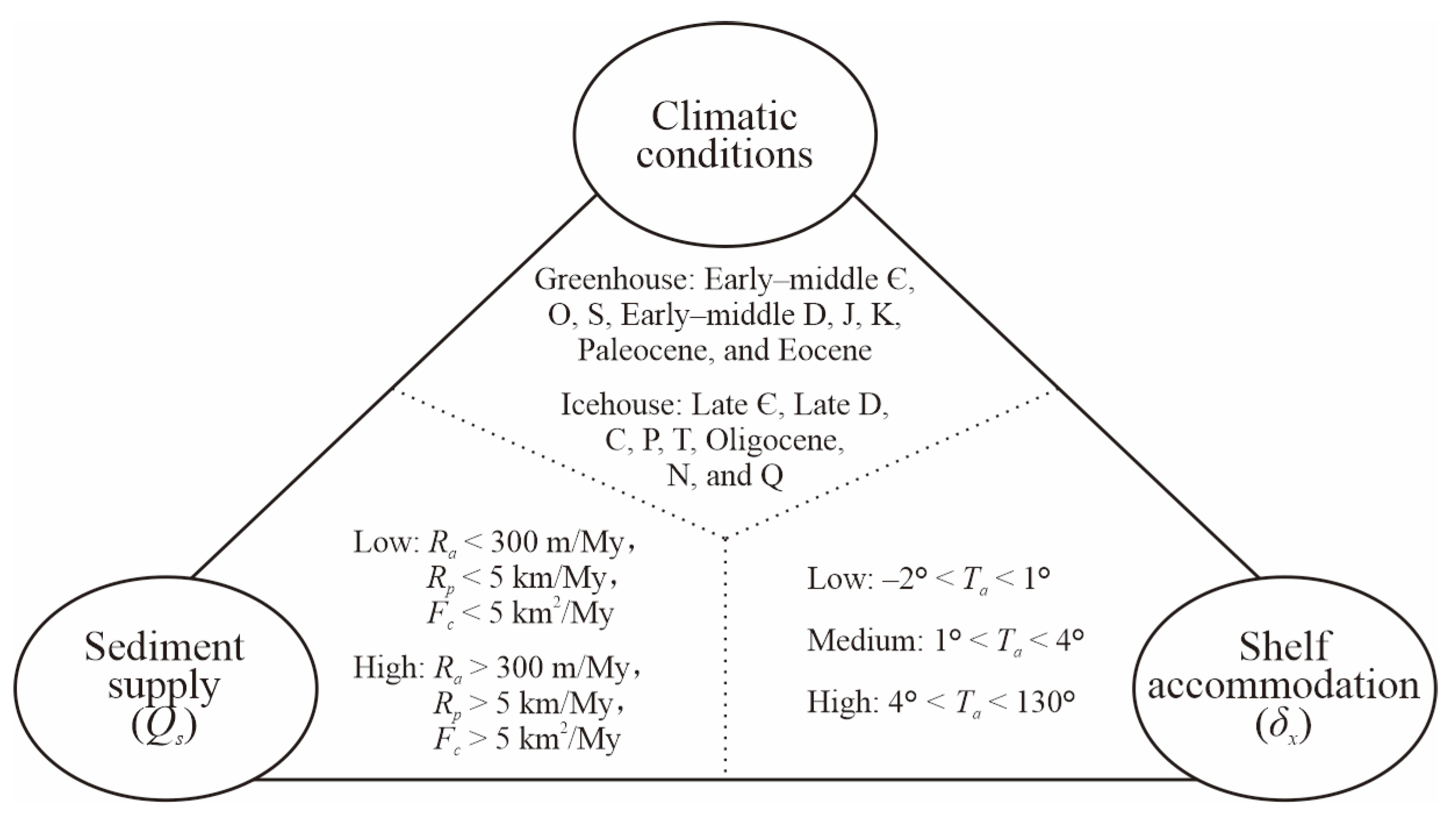
Shoreline and shelf-edge migration are primarily driven by imbalances among sediment supply, accommodation space, and climatic conditions [30]. The interaction of these three directly shapes and controls the architecture of deep-water sedimentary systems. This study adopted the ternary classification system proposed by Gong et al. [3], with appropriate adjustments (Figure 3) to describe the differences in shelf-edge structures, conducting semi-quantitative analysis of the aforementioned three variables [31]. Multiple structural parameters (Table 1) were selected as inputs for the volumetric balance model to determine sediment supply (Qs), shelf accommodation space (δx), and climatic conditions. Using measured seismic profiles from both basins in previous studies and internal research data, we systematically measured the depositional characteristics of the shelf edge [32,33,34].
By comparing deep-water system characteristics, sedimentary architectures, and shelf-margin configurations between the two basins, this study analyzes controlling factors-including regional tectonic activity, hydrodynamic mechanisms (global sea-level changes and paleo-drainage system stability), subcrop geomorphology (e.g., paleo-uplifts and diapirism), and shelf-slope types. We investigate their controls on lithofacies associations, morphological features, development scale, and distribution patterns of deep-water sediments during the late-stage continental drift.

4. Results

4.1. Deep-Water Sedimentary Systems Description

4.1.1. Lithofacies Types

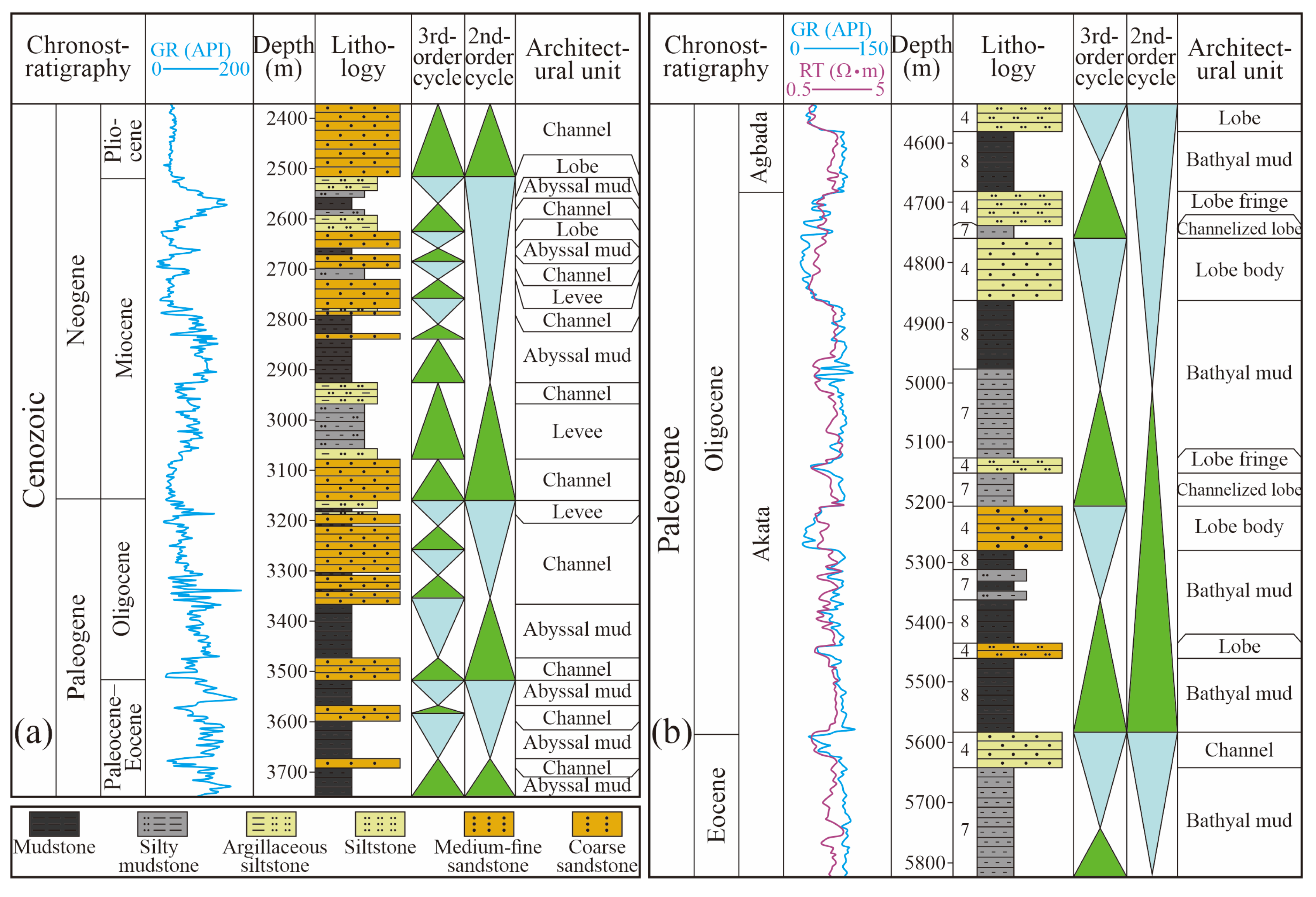
In the Lower Congo Basin, the main vertical lithofacies include deep-water channels, natural levees, lobes, and deep-sea mud (Figure 4a). The lithology of deep-water channels is mainly medium- to fine-grained sandstone interbedded with thin-layered mudstone, with a maximum depth of 180 m, cumulative sandstone thickness of 165 m, and a sand-to-mud ratio exceeding 90%. Natural levees thin laterally in a wedge shape, characterized by thin sand bodies and sand-mud interlayers with low sand content. Lobes develop at the ends of deep-water distributary channels, exhibiting thin sand-mud interlayers and thick sandstones interbedded with thin-layered mudstones, with lobe sandstone thickness of 15–35 m and a sand-to-mud ratio of 40–70%.
In the Niger Delta Basin, the main vertical lithofacies include fan lobes, channels, and semi-deep-sea mud (Figure 4b). Fan lobes can be divided into single lobes and lobe complexes. Single lobes have thinner sand bodies, generally fine- to silt-grained sandstone interlayered with mudstone, with a cumulative sandstone thickness of 15–25 m and a sand-to-mud ratio of 30–50%. Lobe complexes have thicker sand bodies, mainly composed of lobe bodies, channelized lobes, and lobe margins, generally thick medium- to fine-grained sandstone interbedded with thin-layered mudstone, with a maximum cumulative sandstone thickness of 80 m and a sand-to-mud ratio of 50–70%. Sedimentary channels consist of thick medium- to fine-grained sandstone interbedded with thin-layered mudstone, with a cumulative sandstone thickness of 40–90 m and a sand-to-mud ratio of up to 80%.

4.1.2. Major Architectural Unit Characteristics

Deep-Water Channel-Levee Complexes
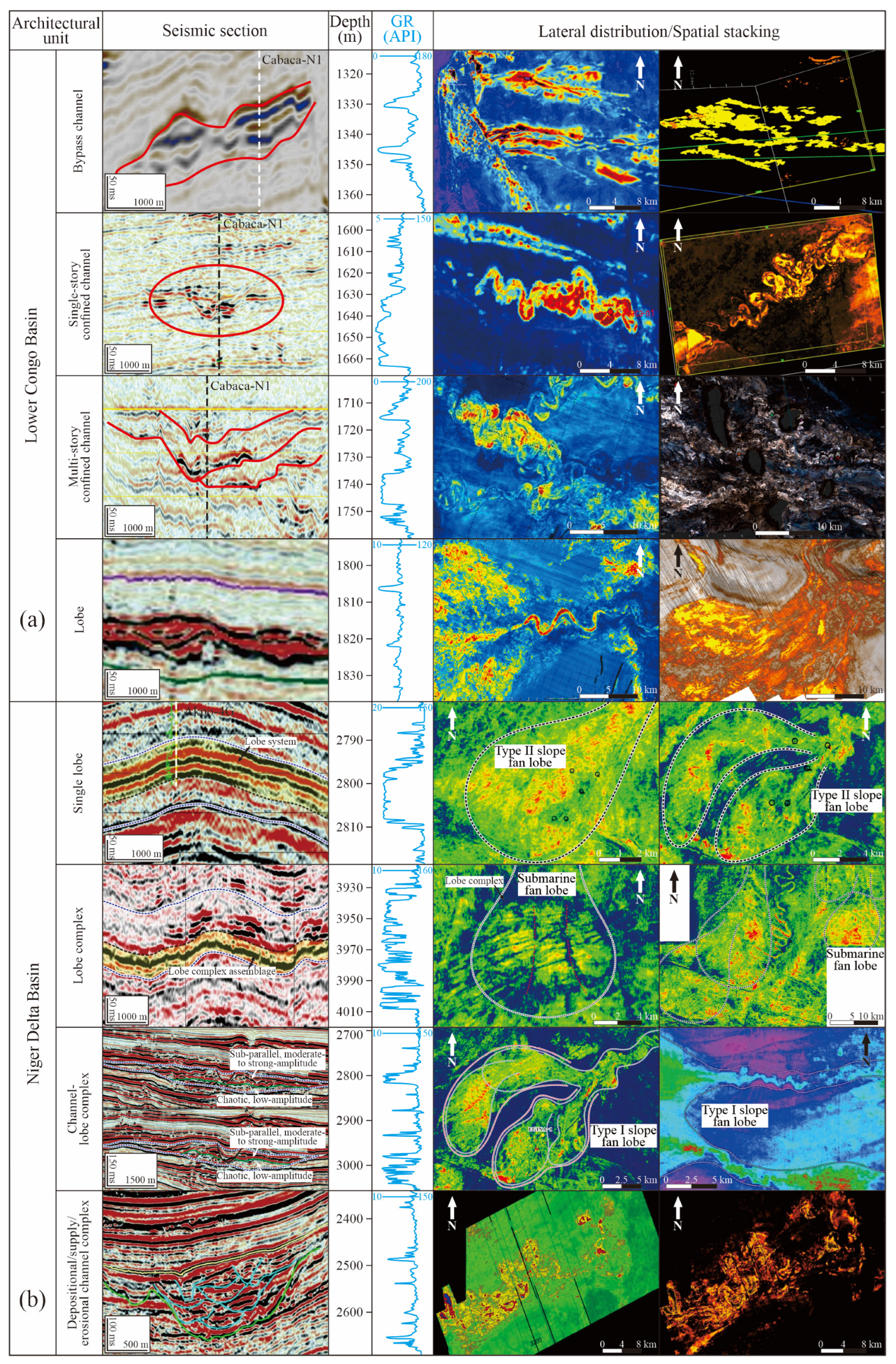
The main sedimentary system in the Lower Congo Basin is deep-water channels, followed by levees and lobes. According to channel location, deep-water channels can be divided into bypass channels, single-stage confined channels, and multi-stage (weakly) confined composite channels (Figure 5a). Turbidity currents often overflow the channel edges, leading to levee deposits on both sides of the channel, forming deep-water channel-levee complexes. Overbank deposits become progressively finer in grain size, thinner in thickness, and lower in flow energy with in-creasing distance outward from the channel margins. Channel-levee systems often exhibit a “U” or “V” shape on seismic profiles, with concaved complexes of 1.5–6 km width in RMS amplitude. They can be divided into inner levee deposits (channel terraces) and channel axis fill deposits, with an erosional boundary containing semi-confined channel deposits at the bottom and wedge-shaped outer levee deposits at the top (Figure 5a). The lower strata of the channel have seismic reflection characteristics of weak amplitude, poor continuity, and chaotic fill [35], with well logs often showing finger-shaped or serrated patterns. The middle strata of the channel exhibit strong amplitude, medium-to-poor continuity, and sub-parallel or chaotic fill seismic facies [36], with well logs showing box-shaped or serrated box-shaped characteristics. The upper strata of the channel are mostly medium-to-weak amplitude, medium-to-good continuity, and parallel-to-sub-parallel seismic reflection characteristics [37], with well logs showing serrated or serrated bell-shaped patterns. Seismic facies cutting across the levees show medium-to-strong amplitude, with amplitude weakening away from the channel edge, forming “gull-wing” seismic reflections with the channel facies.
Fan Lobes
The Niger Delta Basin primarily develops lobe deposits, with channels and levees as secondary features. Defined by their configuration, these lobes are classified into single lobes and lobe complexes, which may combine with channels to form channel-lobe complexes (Figure 5b). Seismically, lobes exhibit high-amplitude, continuous, parallel to sub-parallel reflections, occasionally showing low-angle shingled configurations [38]. They extend laterally over considerable distances with multiple reflection events, representing stacked composite lobe sand bodies. Well logs display high natural gamma ray amplitudes, showing variable patterns (box-shaped, bell-shaped, serrated) corresponding to architectural element combinations. Furthermore, depending on depositional environment, lobe systems divide into submarine fans and slope fans (Figure 5b). Submarine fan lobes demonstrate fan-shaped distributions on RMS amplitude maps. They feature large-scale, high-amplitude contiguous zones indicating sand-rich stacked deposits with minimal channelization [27]. In contrast, slope fan lobes are significantly smaller and comprise two subtypes: (1) Broom or tongue-shaped systems: Relatively larger with complex architectures. These composite lobes contain distinct channels, forming channel-lobe complexes that represent intermediate-stage channel progradation. (2) Elliptical or spindle-shaped systems: Smallest in scale, typically occurring at channel termini. These simpler units consist mainly of single lobes, indicating terminal-stage progradation.

4.2. Comparison of Shelf-Margin Structures and Sedimentary Architectures

During the late drift stage, the average Ra value of the Lower Congo Basin was 135.0 m/My, the average Rp value was 2.9 km/My, the average Fc value was 3.5 km2/My, and the average Ta value was 0.6°, representing low sediment supply, medium-to-low accommodation space, and icehouse climate conditions (Table 1). In contrast, the average Ra value of the Niger Delta Basin during this period was 419.4 m/My, the average Rp value was 8.5 km/My, the average Fc value was 4.1 km2/My, and the average Ta value was 3.1°, representing high sediment supply, medium accommodation space, and icehouse climate conditions (Table 1). In addition, the sinuosity index in the Lower Congo Basin has a mean of 1.3, compared to 1.6 in the Niger Delta Basin, indicating higher channel curvature and greater lateral migration in the latter. The E/C values are 1.3 and 1.5 in the Lower Congo and Niger Delta Basins, respectively, suggesting that due to the extensional zone of the two basins mainly being located on the middle-to-upper slope since the Miocene, the channel E/C values are larger, exhibiting overall erosional characteristics (Table 1).
In the early stage of gravity flow formation, the fluid transport capacity is strong, and the erosion of the lower strata is obvious, leading to the phenomenon of sedimentary bypass. In the middle stage, the fluid energy gradually decreases, forming confined channels rich in basal lag deposits and slump debris flow deposits. In the late stage of gravity flow development, the energy carried by the fluid decreases, and sand-rich sediments begin to accumulate in the incised valley, forming high sand-to-mud ratio weakly confined stacked channels. As the fluid energy further decreases, fine-grained sediments gradually deposit, forming low sand-to-mud ratio channels and basin floor channel-end lobes [36,39] (Figure 6a). In the Lower Congo Basin during the late drift stage, the main architectural units are deep-water channel-levee systems, with proximal lobes composed of distributary channels and sheet sands, and distal lobes composed of thin-layered sheet fine sandstones and mudstone interlayers. Composite channels are an important component of deep-water channel sedimentary architecture, including layers (layer sets), channel units, and single channels (Figure 6b). In the Niger Delta Basin, the sedimentary architecture is mainly fan lobe systems, including medium-to-small scale submarine fans and small-scale slope fans. The key architectural unit, the lobe complex, includes four main types: single swing, double swing, retrogradational, and progradational (Figure 6c). Submarine fan lobe systems are supplied by gravity flow channels on the slope, rapidly depositing in the relatively gentle slope zone (slope fans) and abyssal plain area (submarine fans), exhibiting large-area continuous distributions in plan view [4,22]. The lobe systems are mainly distributed within parasequence sets, composed of multi-stage lobe complexes, with a vertical thickness of up to 100 m. The lithology inside the lobe system is diverse, mainly thick and stable medium-to-fine grained and medium-to-coarse grained sandstones, with a single layer thickness of 5–15 m, with local development of thin sand–mud interlayers. The lobe complex is a high-order level of the fan lobe system, including layers (layer sets), lobe units, and single lobes (Figure 6d). Lobe units embedded in the lobe complex can be locally identified by high-resolution seismic tools (such as seafloor stratigraphic profilers), such as modern lobe complexes [40,41].

5. Discussion: Controlling Factors for Sedimentary Heterogeneity

5.1. Regional Tectonic Setting

Due to different plate tectonic locations, the two basins exhibit significant differences in tectonic background. The Lower Congo Basin is located in the central South Atlantic region, experiencing water evaporation and salinization after intracontinental rifting, and eventually developing marine sediments. The Niger Delta Basin is located at the intersection of the equatorial and South Atlantic, directly entering marine sedimentation after intracontinental rifting, without the formation of an evaporite environment. Due to the periodic activity of the Walvis Ridge, the initial ocean north of it was sometimes connected with the South Atlantic, resulting in the development of large areas of alternating terrestrial-marine evaporite deposits from the Santos Basin to the Douala Basin during the Aptian [42].
During the continental drift stage, both basins saw the emergence of gravity-driven structures related to plastic salt and shale layers. The main difference in tectonic activity lies in the differences in the tectonic processes and characteristics of salt tectonics and mud tectonics. On the central West African margin, the Aptian salt layer only developed one detachment, but it was activated in two main stages, resulting in four salt tectonic activities (Figure 7a). On the equatorial West African margin, three detachments of the intrabasinal shale layer led to extensional structures on the upper slope and thrust structures on the lower slope (Figure 7b). The evolution of sedimentation rate over time also shows that although the tectonic styles of the marginal basins in the two regions are different, they are closely related to gravity tectonics (Figure 7). On the central West African margin, the rapidly changing sedimentation rate is related to salt tectonic activity since the Late Cretaceous and the Oligocene [43]. In contrast, the equatorial West African margin is driven by an accelerating sedimentation rate, and long-term tectonic deformation activates the overlying detachment surface. The above all indicate that sedimentary loading plays a leading role in the activation of gravity tectonics. Another key parameter is the slope of the detachment, which is mainly controlled by the marginal tilting caused by thermal subsidence and sediment loading, and is also affected by regional tectonics [44] (Figure 7). In addition, since the Oligocene, the Lower Congo Basin has continued to deposit, while the onshore part has continued to uplift, and has experienced large-scale erosion during low water levels. The Niger Delta, on the other hand, was affected by the Cameroon volcanic belt on the east side in the Miocene, resulting in a large number of collapses, which also provided a large amount of volcanic debris source for the basin.
The uplift of the southwestern African margin in the Miocene led to increased onshore erosion and deep-cut canyon development in the Lower Congo Basin, making the overall terrain of the basin steeper, enhancing the erosion capacity of gravity flow channels, and significantly increasing the E/C value (Table 1). A comparison of the sedimentary characteristics of the channel systems in different periods in the Lower Congo Basin shows that the Oligocene period was dominated by the development of high-migration channels, with an E/C value of only 0.6, representing depositional channels with low erosion capacity, and lacking uniform outer levee confinement between multiple single channels. The Miocene channel system is characterized by relatively low-migration channels, with an E/C value greater than 2.0, representing a high-erosion capacity channel system, with internal single channels confined (Figure 8a).
Since the Eocene, the Niger Delta Basin has formed a progradational delta. With the continuous accumulation and thickening of detritus on the margin, the transitional crust and the basin as a whole have continued to subside [45]. The basin as a whole continues to prograde in a step-like manner, with continuous evolution of sedimentary belts. Although the overall tectonic pattern changes little, the extensional, transitional, and compressional tectonic zones have developed in each period, and the location is constantly migrating towards the sea. This leads to a large difference in the sedimentary characteristics between the early deep-water sedimentary systems and the late deep-water sedimentary systems in the same location. The early abyssal plain area develops unconfined sedimentary systems, while the late stages form thrust-fold structures as the compressional tectonic zone migrates seaward, limiting the development range of gravity flow channels (Figure 8b).

5.2. Oceanographic Controls

5.2.1. Global Sea Level Changes

Since the late continental drift (Eocene), the Lower Congo Basin began to form turbidite fans, while the Niger Delta Basin began to develop true delta progradational bodies. On the long-term cycle scale of global sea level, the overall trend is downward, so the Oligocene strata of both basins generally show a progradational development trend, and the progradation rate has significantly accelerated since the Miocene (Figure 9). In the Lower Congo Basin, tectonic uplift (with a maximum uplift height of 500 m) has caused the Oligocene and its overlying strata to be eroded on the landward side, and the change in the base level has caused the later channels to erode the bypass fan. During the low sea level period, submarine canyons developed in the basin, and the strata in a certain stage of the Miocene rapidly prograded seaward and then rapidly retrograded, which may be related to rapid tectonic uplift [7]. The sharp drop in sea level near the Niger Delta Basin has led to the formation of shelf erosion canyons, and changes in relative sea level in some areas have also changed the base level, thereby affecting the development style of deep-water sediments.
Since the Oligocene, the Niger Delta Basin has experienced multiple low sea level periods, forming specific sedimentary environments on the shelf edge. The Lower Congo Basin, on the other hand, has multiple unconformities, resulting in the erosion of strata in the terrestrial-marine transition area, making its paleogeomorphic pattern difficult to determine, and making it impossible to infer whether there are corresponding sedimentary systems at different sea level positions that change the position on the shelf (Figure 9). In addition, studies on the Oligocene of the Lower Congo Basin show that gravity flow sediments are fully developed, especially under the conditions of superimposed third-level and fourth-level sequence lowstand periods.

5.2.2. Paleodrainage Stability

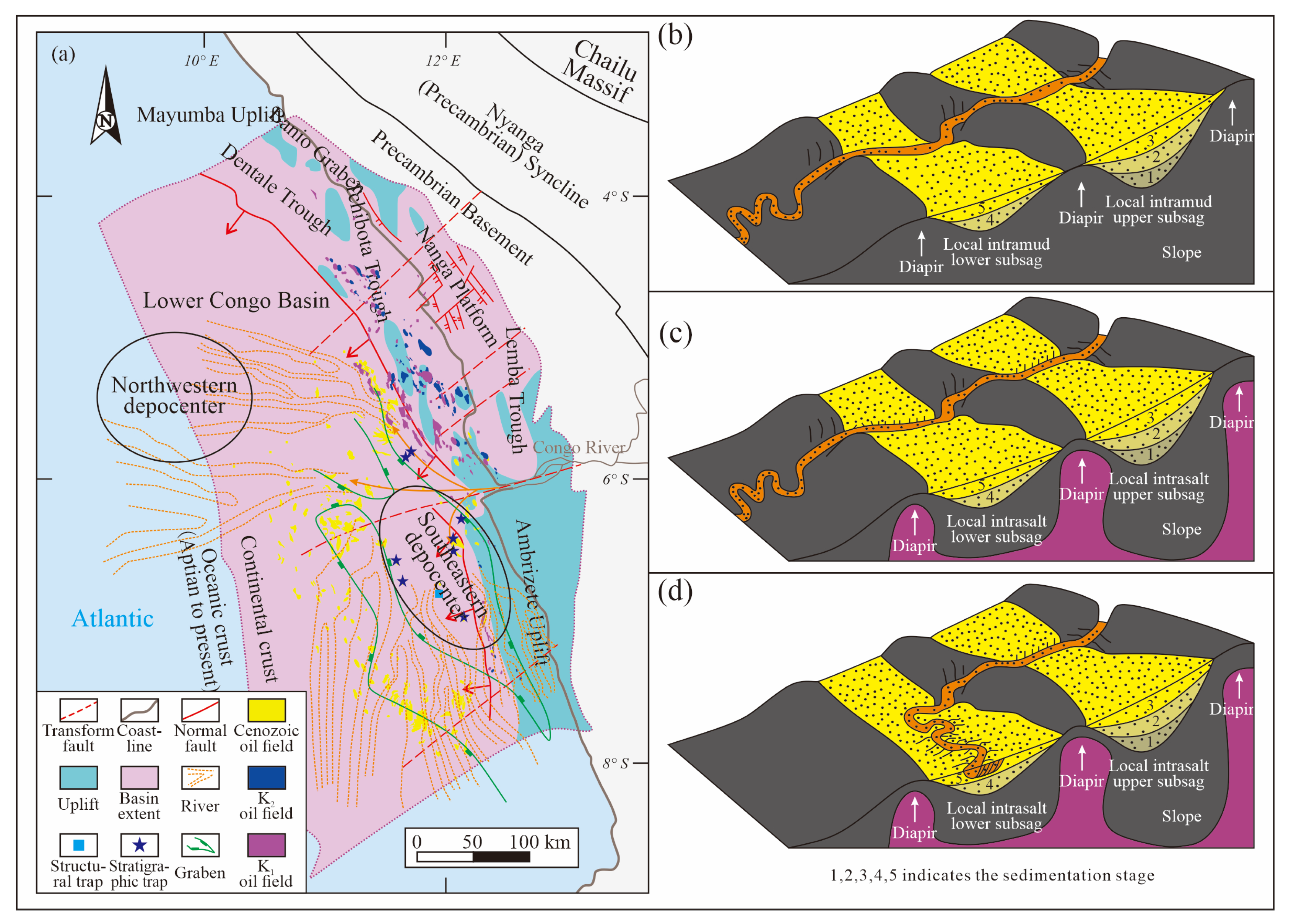
The reason the seawater in the Niger Delta Basin has not been salinized and has a stable ancient water system is that the freshwater injection and tectonic location are relatively stable. In contrast, the ancient water system stability of the Lower Congo Basin is poor [47]. In the Niger Delta Basin, the uplift of the terrestrial shoulder allows the ancient water system to flow along the fault zone, while the ancient water system development of the Lower Congo Basin is controlled by strike-slip fault zones. The extensional zone of the Lower Congo Basin can be divided into small salt raft areas and giant salt raft areas (Figure 1d). The rolling fault blocks in the giant salt raft area have large lateral spans (>20 km), including the entire post-salt strata since the Early Cretaceous, with a thickness of 3–6 km. The faults in this area have large fault throws and are typical listric faults. The Cretaceous fault blocks are separated by Tertiary sediments. The section direction of the listric fault can be forward (inclined to the east) or reverse (inclined to the west), so local grabens are easily formed between these two major faults, thereby affecting the basin’s water system distribution and sedimentary center position. During the Oligocene to Miocene period, the Lower Congo Basin successively saw two sedimentary centers: one located in the southeastern part of the basin within Angola, roughly extending along the slope direction and parallel to the strike of the listric faults forming the graben; the other located in the northwestern part of the basin within Congo, radiating outwards from the center of the current canyon axis (Figure 10a). From the Oligocene to the mid-Miocene, turbidite sediments were mainly concentrated in the southeastern sedimentary center. It was not until the late Miocene that the sedimentary center began to migrate to the northwest, while the original southeastern sedimentary center had almost no sedimentary turbidite sand bodies during this period [19].

5.3. Pre-Depositional Substrate Geometry

5.3.1. Paleouplift

Compared with the overall tectonic pattern of the basin, the migration of the sedimentary center in the deep-water area is more affected by local geomorphic changes. In the Lower Congo Basin, local highs and paleohighs play an important role in deep-water sedimentary characteristics and hydrocarbon enrichment. In addition to promoting water system aggregation and outcrop erosion (often occurring in gentle slope zones), and being conducive to the development of carbonate reservoirs (providing growth conditions for bioherms), the up-dip direction of paleohighs also easily forms effective traps (conducive to the development of fractured and shallow-marine clastic rock reservoirs) and serves as an important channel for oil and gas migration [48]. For example, the oil and gas reservoirs of the Lower Cretaceous Bucomazi Formation source rocks in the Lower Congo Basin are mainly distributed in the Mayumba uplift, the Ambrizete uplift, and the high positions between the two (Figure 10a). Compared with the basement paleohighs before the drift period in the Lower Congo Basin, the Niger Delta Basin has a later development time, so it is mostly dominated by structural uplifts caused by mud diapirism.

5.3.2. Shale and Salt Diapirism

Shale usually only has plasticity and can move under overpressure conditions, so its development and evolution often show phased characteristics. Previous studies have used the “step-like” evolution model to explain this phased evolution, that is, the location of the diapir transition zone in a certain period is usually the formation location of the main fault zone in the next period [47]. The formation of salt structures still continues after salt deposition, and its formation and development are controlled by multiple factors, such as the source supply and dissolution rate of salt, the deposition and erosion rate of overlying strata, and the degree of extension and compression. The factors that cause salt to flow and deform mainly include differential loading, density difference with surrounding rocks, thermal convection, and stress environment, of which density difference is considered to be the most important triggering factor [49].
Salt structures and mud structures have differences in formation mechanism and evolution process, which promote the geometry, development and change in salt rocks to be more diverse, and not as regular as mud rocks. In the near-land area of salt-bearing basins, salt welding and salt raft structures under extensional conditions are generally developed, while the transition zone mainly develops salt stocks, salt walls, salt diapirs, and turtle back structures formed in the transition environment. In the compression zone at the foot of the slope, compressive salt structures are mainly developed, such as salt thrusts and compressive diapirs [47,50]. In contrast, the development amplitude and scale of mud structures are smaller, and they do not develop complex structures in multiple stages like salt rocks.
The diapirs in the transition tectonic zone of the Niger Delta Basin are mainly large mound-shaped mud diapirs, and the development density gradually increases from the extensional zone to the transition zone. The filling process of local depressions is shown in Figure 11b. Local uplifts are first filled, and then gravity flow enters the local downwarps after filling. As the base level drops, the diapir core and the lobes in the upper uplifts are eroded, and then the downwarps are also filled, and the channel enters the next-level downwarp. This process continues until the deep-sea plain. The salt diapirs developed in the Lower Congo Basin are slightly different from the mud diapirs. The geometry of salt diapirs is more diversified. Not only does the density increase from land to sea, but the diapir form also changes from isolated salt diapirs to laterally extending salt ridges or salt walls [47]. Multiple salt ridges enclose small depressions, and channels spread within them to form lobes or channelized lobes; trough-shaped terrains are easily formed between salt walls, forming channel confluence or restricting channel development. The development of local depressions in the basin salt structure can be divided into two situations: one is similar to mud structure sub-basins, where the channel directly erodes the diapir core (Figure 10c); the other is that the channel makes a turn and enters the next-level depression in other parts (Figure 10d).

5.4. Shelf-Slope Geometry

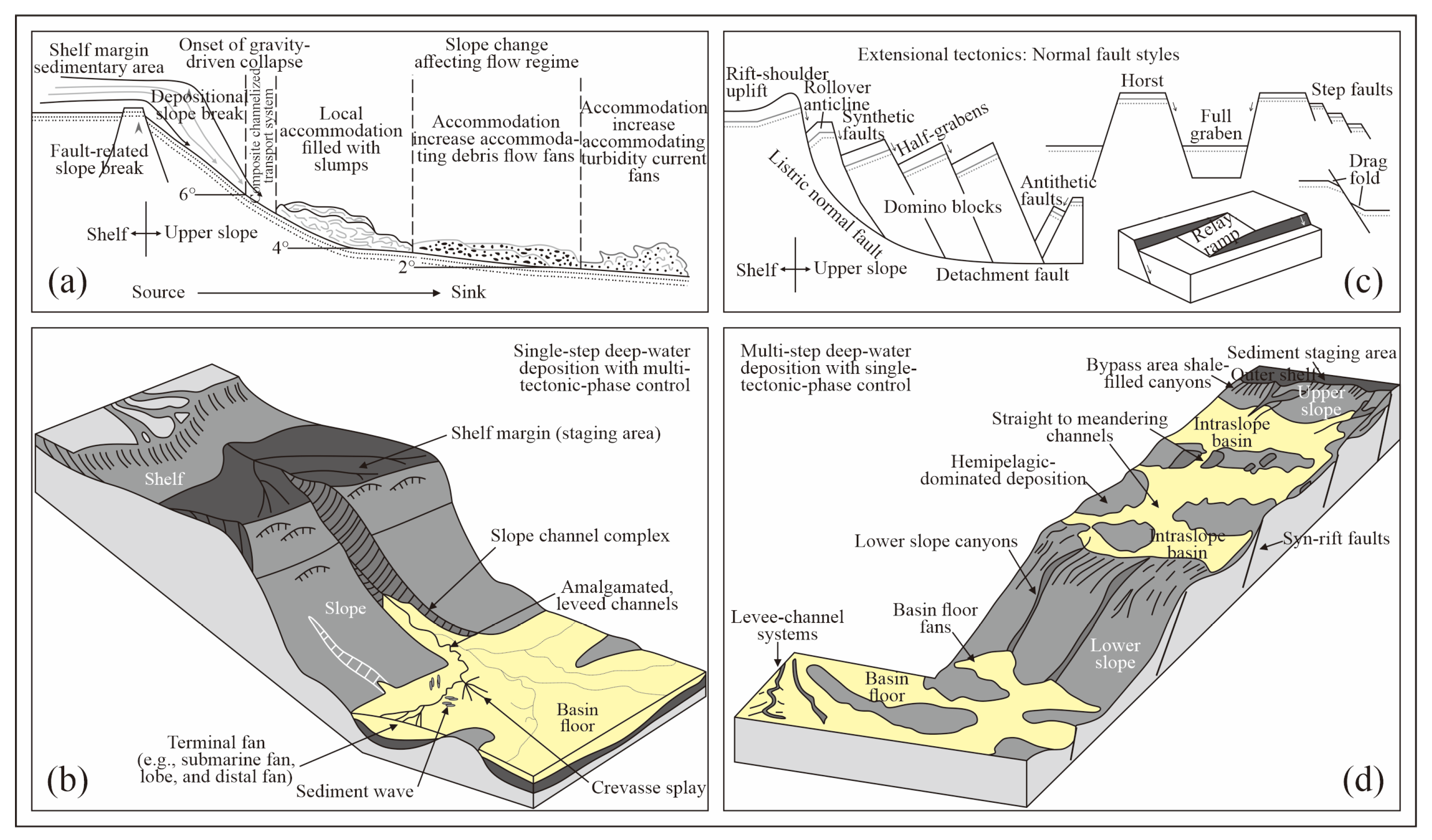
In terms of shelf and slope types, the Lower Congo Basin has a single-step narrow shelf-steep slope type, and the fan bodies are mainly formed in the lower slope and deep-water basin of the basin (Figure 11a,b); while the Niger Delta Basin has a multi-step wide shelf-gentle slope type, and the slope fan and submarine fan lobes are mostly developed on the upthrown side of the growth faults on the upper slope, the diapir depressions in the transition zone, or the basin floor area (Figure 11c,d).
The Congo Fan is mainly supplied by a single point source from the Congo River, and the source is continuously deposited at the fault slope break on the shelf edge. Because the structural pattern of the slope is simple, only a single-stage stepped slope is developed, but it has also experienced multiple periods of structural erosion (Figure 9). After the progradation thickening causes gravity collapse to start, the sediments develop into a composite channel transport system. Then, as the slope gradually decreases and the accommodation space continues to expand, the flow state of the slope sediments gradually changes from a slump body to a debris flow fan body and finally to a turbidite fan body (Figure 11a). The Lower Congo Basin has a large topographic drop and turbulent water flow due to tectonic uplift, and mud and sand are not easily deposited at the river mouth. Under the condition of continuous progradation, a large composite levee valley—the Congo Submarine Canyon—has been formed, with an average slope exceeding 40°, belonging to a high and steep canyon, so it is not easy to form a delta. The source detritus carried by the Congo River is directly transported to the basin floor plain through the Congo Canyon. The source erosion of the deep-cut canyon also narrows the shelf edge, making it difficult for deposition to occur on the shelf and upper slope. As the hydrodynamic force weakens, the channels begin to bifurcate on the lower slope and deep-sea plain, the scale gradually decreases and the number of tributaries increases, changing from erosional to aggradational, and forming submarine fans, frontal fans, and lobes at the end, and displaying a branching tree structure. The overall shape of the Congo Fan is a divergent tree-like shape, that is, a “single-step narrow shelf-steep slope rooted deep-water fan” (Figure 11b). The fan root area of this type of deep-water fan develops canyons and large channel complexes, the channel scale in the fan middle becomes smaller, and the fan end develops natural levees and channel end fans. The whole is mainly composed of channel deposits, followed by natural levees and fan lobes [22].
The Niger Fan is supplied by multiple points from the Niger River and the Niger Delta. Because the structural pattern of the slope is relatively complex, a multi-stage stepped slope is developed, but only a single-stage structural erosion has occurred (Figure 9). The sediments flow from the graben shoulder uplift of the shelf edge through the conversion slope to form a stepped upper slope, and finally extend to the deep sea or basin floor plain. The stepped upper slope is usually a domino-style fault block jointly composed of listric normal faults and detachment faults, including rolling anticlines, syn/antithetic faults, and half-grabens, or step-like faults formed by alternating horsts and grabens (Figure 11c). Since the Miocene, the Niger Delta Basin has continued to subside, the terrain is gentle, and the water flow is slow, leading to a lack of development of large canyons on the landward side of the Niger Fan, while mud and sand are easily deposited at the river mouth to form deltas. Under the gravity drive, terrestrial detritus is transported from the sediment accumulation area on the shelf edge to the deep-water area along the upper slope shale-filled canyons, straight-curved channels, and lower slope small canyon channels, forming a sheet-like deep-water submarine fan on the basin floor. Due to the gentle slope and the existence of synsedimentary stepped faults, some detrital materials are deposited in the intra-slope basins of the upper slope during the migration process to form slope fans, that is, “multi-step wide shelf-gentle slope unrooted deep-water fans” (Figure 11d). The fan root area of this type of deep-water fan does not develop large canyons and channels, and the fan middle and fan end mainly deposit lobe bodies, followed by deep-water channels [22].

5.5. Impact on Oil and Gas Exploration

This comparative study of deep-water sedimentary architectures in the Lower Congo and Niger Delta basins provides significant value for hydrocarbon exploration and development. It establishes a tectono-sedimentary framework linking salt/mud diapirism, shelf-slope morphology, and sediment pathways, enabling more accurate prediction of turbidite reservoir distribution (e.g., channel-levee complexes vs. fan lobes) in passive margins influenced by halokinesis. By quantifying how diapir-induced seafloor relief redirects sediment transport and amplifies facies heterogeneity, the research reduces exploration uncertainty in analogous basins, particularly regarding reservoir connectivity and compartmentalization. The identified contrast between the Lower Congo’s narrow-shelf, erosional systems dominated by channels/terminal lobes and the Niger Delta’s broad-shelf, progradational systems rich in delta-fed turbidites and lobes offers critical guidance for targeted exploration strategies: prioritizing terminal lobes in salt-influenced settings and delta-fed turbidites in high-sediment-supply regions. Furthermore, understanding the architectural controls (e.g., tectonic uplift, diapir evolution) optimizes well placement and development plans for complex deep-water reservoirs. These insights refine conventional “source-to-sink” models and directly support efficient resource exploitation in West Africa and global deep-water analogs.

6. Conclusions

(1)
Since the Eocene, the Lower Congo Basin has mainly formed a narrow shelf-steep slope retrogradational deep-water turbidite sand system, showing that the basin fan bodies have changed from multi-source small to single-source large, single-step deposition, mainly developing deep-water turbidite/erosion channels, levees, large-scale terminal lobes, and deep-sea mud, controlled by margin uplift tilting and the degree of salt tectonic activity, gradually transitioning from salt diapirs to salt walls from land to sea, resulting in channel flow changes or lobe formation.
(2)
In the late stage of continental drift, the Niger Delta Basin is mainly a wide shelf-gentle slope large-scale progradational delta and its distal sand system, multi-point source supply, multi-step development, mainly depositing delta front underwater distributary channels, prodelta-semi-deep-sea mud, and medium-to-small-scale submarine fan lobes and small-scale slope fan lobes dominated by sedimentary channel-fan lobes, controlled by gravity-driven systems with mud structures as detachment surfaces, and mound-shaped mud diapirs form local uplifts.
(3)
A comparison of the shelf-edge structure styles and sedimentary architectural characteristics in the late stage of continental drift shows that the Lower Congo Basin is in a condition of low sediment supply, medium-to-low equal accommodation space, and icehouse climate, mainly developing by-pass type and single (multi)-period confined deep-water channel-natural levee systems; while the Niger Delta Basin belongs to a high sediment supply, medium accommodation space, and icehouse environment, mainly composed of various lobe systems such as retro(pro)gradational and single (double)-directional swing types.
(4)
Deltaic sedimentation can be regarded as a turbidite sedimentary system less affected by upwelling. Due to the constraints of various factors such as tectonic background, sea level changes, paleo-geomorphology, mud/salt diapirism, and shelf-slope types, there are differences in shelf-edge structure styles and sedimentary configurations between the two types of passive margin basins. Among them, regional or local tectonic activity is the main factor controlling deep-water turbidite sedimentation in the late stage of continental drift in the two basins, and sea level changes also affect the development of deep-water systems to a certain extent, while the differences in shelf-slope types and basin floor paleohighs are specific manifestations of the former two in the deep-water sedimentation process.

Author Contributions

Conceptualization, X.G. and J.Y.; methodology, F.Q.; software, F.Q.; validation, L.G. and X.G.; investigation, X.G.; resources, X.G. and J.Y.; writing—original draft preparation, F.Q.; writing—review and editing, L.G.; supervision, X.G.; project administration, X.G.; funding acquisition, X.G. and L.G. All authors have read and agreed to the published version of the manuscript.

Funding

This work was jointly funded by the National Science and Technology Major Projects of China (Grant No. 2016ZX05033-001) and the Special Scientific Research Fund of Yunnan Communications Vocational and Technical College (Grant No. 202501JTBS001).

Data Availability Statement

The original contributions presented in this study are included in the article material. Further inquiries can be directed to the corresponding author.

Acknowledgments

We thank the Petroleum Exploration and Production Research Institute, SINOPEC Group for providing core samples, drilling/logging records, seismic data, and publication permission. We acknowledge Zequan Hu, Yubin Hu, and Weiting Wang for their preliminary work on core analysis, data processing, and seismic interpretation. We are grateful to the editors and reviewers for their insightful comments, which significantly improved this manuscript.

Conflicts of Interest

The authors declare no conflicts of interest. The funders had no role in the design of the study; in the collection, analyses, or interpretation of data; in the writing of the manuscript; or in the decision to publish the results.

References

  1. Reading, H.G.; Richards, M. Turbidite systems in deep-water basin margins classified by grain size and feeder system. AAPG Bull. 1994, 78, 792–822. [Google Scholar] [CrossRef]
  2. Marcano, G.; Anka, Z.; di Primio, R. Major controlling factors on hydrocarbon generation and leakage in South Atlantic conjugate margins: A comparative study of Colorado, Orange, Campos and Lower Congo basins. Tectonophysics 2013, 60, 172–190. [Google Scholar] [CrossRef]
  3. Gong, C.; Steel, R.J.; Wang, Y.; Lin, C.; Olariu, C. Shelf-margin architecture variability and its role in sediment-budget partitioning into deep-water areas. Earth-Sci. Rev. 2016, 154, 72–101. [Google Scholar] [CrossRef]
  4. Zhang, J.J.; Wu, S.; Hu, G.; Fan, T.-E.; Yu, B.; Lin, P.; Jiang, S. Sea-level control on the submarine fan architecture in a deepwater sequence of the Niger Delta Basin. Mar. Pet. Geol. 2018, 94, 179–197. [Google Scholar] [CrossRef]
  5. Wang, L.L.; Wang, Z.Q.; Xiao, P. Characterization of deep water sedimentary system in the Miocene of Block A in Lower Congo Basin. Oil Gas Geol. 2015, 36, 963–974. [Google Scholar]
  6. Zhao, P.F.; Zhang, H.; Bu, F.; Wu, J.; Yang, X. The sedimentary architecture characteristics and fluid system of the deep sea turbidite-lobe complex sandbodies: A case study of the deep-water region in the Niger Delta Front. Earth Sci. 2017, 42, 1972–1983. [Google Scholar]
  7. Li, Q.; Wu, W.; Kang, H.Q.; Ren, S.J.; Pang, L.A.; Yang, T.; Cai, L.L.; Liu, X.L. Characteristics and controlling factors of deep-water channel sedimentation in Lower Congo Basin, West Africa. Oil Gas Geol. 2019, 40, 917–929. [Google Scholar]
  8. Weimer, P.; Slatt, R.M. Introduction to the Petroleum Geology of Deepwater Settings; AAPG/Datapages: Tulsa, OK, USA, 2007. [Google Scholar]
  9. Qin, Y.Q.; Ba, D.; Xu, H.L.; Liang, Y.B.; Yang, Z.; Liang, X.; Wang, X.L. Sedimentation and hydrocarbon accumulation of deep-water fan fed by large canyon in passive continental margin: A case of Congo fan in West Africa. China Pet. Explor. 2018, 23, 59–68. [Google Scholar]
  10. Posamentier, H.; Walker, R. Deep-Water Turbidites and Submarine Fans; SEPM Special Publication: Tulsa, OK, USA, 2006; pp. 399–520. [Google Scholar]
  11. Hüneke, H.; Mulder, T. Deep-Sea Sediments; Elsevier: Amsterdam, The Netherlands, 2011. [Google Scholar]
  12. Liu, X.Y. Depositional characteristics and evolution of the Tertiary deep-water fan in West Africa. J. Northeast. Pet. Univ. 2013, 37, 24–31. [Google Scholar]
  13. Wang, W.G.; Tong, X.G.; Zhang, Y.X.; Cheng, K.N. Features of major passive continental margin basins, South Atlantic Ocean. China Pet. Explor. 2012, 17, 62–69. [Google Scholar]
  14. Estrella, G. Breaking paradigms giant and super-giant discoveries in Brazil. In Proceedings of the AAPG Annual Conventional and Exhibition, Denver, CO, USA, 7–10 June 2009. [Google Scholar]
  15. Qin, Y.Q.; Zhang, G.Y.; Liang, Y.B.; Wen, Z.X.; Wang, Z.M.; Zhang, L.; Ba, D.; Wang, Y.H. Distribution characteristics, accumulation rules and exploration directions of deep water hydrocarbon in South Atlantic. Nat. Gas Geosci. 2016, 27, 229–240. [Google Scholar]
  16. IHS. International Energy Oil & Gas Industry Solutions; IHS: Rockville, MD, USA, 2014. [Google Scholar]
  17. Feng, Y.W.; Qu, H.J.; Zhang, G.C.; Mi, L.J.; Fan, Y.H.; Guan, L.Q. Toctonic-Sedimentary Evolution and its Control on Source-Reservior-Cap Rocks in Passive Continental Margin, West Africa. Mar. Orig. Pet. Geol. 2010, 15, 45–51. [Google Scholar]
  18. Luo, Y.; Li, J.H.; Yang, M.L. A comparative study of tectonic and sedimentary evolution of West African coastal basins in the south Atlantic Ocean region. Geol. China 2021, 48, 120–128. [Google Scholar]
  19. Anka, Z.; Séranne, M.; Lopez, M.; Scheck-Wenderoth, M.; Savoye, B. The long-term evolution of the Congo deep-sea fan: A basin-wide view of the interaction between a giant submarine fan and a mature passive margin (ZaiAngo project). Tectonophysics 2009, 470, 42–56. [Google Scholar] [CrossRef]
  20. Deng, R.J.; Deng, Y.H.; Yu, S.; Hou, D.J. Hydrocarbon geology and reservoir formation characteristics of Niger Delta Basin. Pet. Explor. Dev. 2008, 35, 755–762. [Google Scholar]
  21. Navarre, J.-C.; Claude, D.; Liberelle, E.; Safa, P.; Vallon, G.; Keskes, N. Deepwater turbidite system analysis, West Africa: Sedimentary model and implications for reservoir model construction. Lead. Edge 2002, 21, 1132–1139. [Google Scholar] [CrossRef]
  22. Cai, L.L.; Wang, Y.; Wang, Y.; Dong, S.; Zhu, S.; Liao, J.; Zhao, Z.; Xue, D. Type features and hydrocarbon exploration significance of deepwater sedimentary in West Africa. Acta Pet. Sin. 2016, 37, 131–142. [Google Scholar]
  23. Liu, X.Y.; Yu, S.; Tao, W.X.; Hu, X.L.; Hao, L.H. Filling architecture and evolution of Upper Miocene deep-water channel in Congo Fan Basin. Earth Sci. 2012, 37, 105–112. [Google Scholar]
  24. Hooper, R.J.; Fitzsimmons, R.J.; Grant, N.; Vendeville, B.C. The role of deformation in controlling depositional patterns in the south-central Niger Delta, West Africa. J. Struct. Geol. 2002, 24, 847–859. [Google Scholar] [CrossRef]
  25. Shi, S.Y.; Yu, Y.X.; Yin, J.Y.; Wu, C.W.; Liu, J.J.; Liu, Y.L.; Wang, B. Deformation characteristics and formation mechanisms of salt structures in the Lower Congo Basin. Oil Gas Geol. 2020, 41, 1092–1099. [Google Scholar]
  26. Feng, Z.Q.; Guo, F.T.; Zhang, Z.M.; Yin, J.Y.; Tian, N.X.; Su, Y.S.; Guo, R.T.; Wu, G.K. A transform margin: Review of genetic types of the Niger Delta Basin. Acta Petrol. Sin. 2022, 38, 2565–2580. [Google Scholar]
  27. Cai, L.L.; Xie, X.J.; Li, J.P.; Liao, J.H. Influence of different modes of deep-water sedimentation on oil and gas distribution: A case study of deep-water fans in eastern and western Niger Delta Basin. Acta Sedimentol. Sin. 2022, 40, 229–243. [Google Scholar]
  28. Partyka, G.; Gridley, J.; Lopez, J. Interpretational applications of spectral decomposition in reservoir characterization. Lead. Edge 1999, 18, 353–360. [Google Scholar] [CrossRef]
  29. Pigott, J.D.; Abdel-Fattah, M. Seismic stratigraphy and geomorphology of offshore Tanzania. Interpretation 2014, 2, 1–13. [Google Scholar]
  30. Catuneanu, O.; Galloway, W.E.; Kendall, C.G.; Miall, A.D.; Posamentier, H.W.; Strasser, A.; Tucker, M.E. Sequence stratigraphy: Methodology and nomenclature. Newsl. Stratigr. 2011, 44, 173–245. [Google Scholar] [CrossRef]
  31. Allen, P.A.; Armitage, J.J.; Carter, A.; Duller, R.A.; Michael, N.A.; Sinclair, H.D.; Whitchurch, A.L.; Whittaker, A.C. The Qs problem: Sediment volumetric balance of proximal foreland basin systems. Sedimentology 2013, 60, 102–130. [Google Scholar] [CrossRef]
  32. Jermannaud, P.; Rouby, D.; Robin, C.; Nalpas, T.; Guillocheau, F.; Raillard, S. Plio-Pleistocene sequence stratigraphic architecture of the eastern Niger Delta: A record of eustasy and aridification of Africa. Mar. Pet. Geol. 2010, 27, 810–821. [Google Scholar] [CrossRef]
  33. Armitage, D.A.; McHargue, T.; Fildani, A.; Graham, S.A. Postavulsion channel evolution: Niger Delta continental slope. AAPG Bull. 2012, 96, 823–843. [Google Scholar] [CrossRef]
  34. Wang, L.L.; Wang, Z.Q.; Yu, S.N.N.R. Seismic responses and controlling factors of Miocene deepwater gravity-flow deposits in Block A, Lower Congo Basin. J. Afr. Earth Sci. 2016, 120, 31–43. [Google Scholar] [CrossRef]
  35. Schwab, A.M.; Cronin, B.T.; Ferreira, H. Seismic expression of channel outcrops: Offset stacked versus amalgamated channel systems. Mar. Pet. Geol. 2007, 24, 504–514. [Google Scholar] [CrossRef]
  36. Mayall, M.; Jones, E.; Casey, M. Turbidite channel reservoirs—Key elements in facies prediction and effective development. Mar. Pet. Geol. 2006, 23, 821–841. [Google Scholar] [CrossRef]
  37. Posamentier, H.W.; Kolla, V. Seismic geomorphology and stratigraphy of depositional elements in deep-water settings. J. Sediment. Res. 2003, 73, 367–388. [Google Scholar] [CrossRef]
  38. Wang, W.W.; Wang, D.; Sun, J.; Shao, D.; Lu, Y.; Chen, Y.; Wu, S. Evolution of deepwater turbidite bedforms in the Huaguang channel–lobe transition zone revealed by 3D seismic data in the Qiongdongnan Basin, South China Sea. Geomorphology 2020, 370, 107412. [Google Scholar] [CrossRef]
  39. Guo, X.; Liu, X.; Zheng, T.; Zhang, H.; Lu, Y.; Li, T. A mass transfer-based LES modelling methodology for analyzing the movement of submarine sediment flows with extensive shear behavior. Coast. Eng. 2024, 191, 104531. [Google Scholar] [CrossRef]
  40. Prélat, A.; Hodgson, D.M.; Flint, S.S. Evolution, architecture and hierarchy of distributary deep-water deposits: A high-resolution outcrop investigation from the Permian Karoo Basin, South Africa. Sedimentology 2009, 56, 2132–2154. [Google Scholar] [CrossRef]
  41. Picot, M.; Droz, L.; Marsset, T.; Dennielou, B.; Bez, M. Controls on turbidite sedimentation: Insights from a quantitative approach of submarine channel and lobe architecture (Late Quaternary Congo Fan). Mar. Pet. Geol. 2016, 72, 423–446. [Google Scholar] [CrossRef]
  42. Yu, X.; Hou, G.T.; Dai, S.H.; Han, Y.C.; Xie, J.L. Comparison of petroleum geology characteristics and hydrocarbon accumulation regularity of deep water basins in eastern part of Brazil. Mar. Orig. Pet. Geol. 2016, 21, 61–72. [Google Scholar]
  43. Leturmy, P.; Lucazeau, F.; Brigaud, F. Dynamic interactions between the Gulf of Guinea passive margin and the Congo River drainage basin: Morphology and mass balance. J. Geophys. Res. 2003, 108, 1–19. [Google Scholar] [CrossRef]
  44. Séranne, M.; Anka, Z. South Atlantic continental margins of Africa: A comparison of the tectonic vs climate interplay on the evolution of equatorial west Africa and SW Africa margins. J. Afr. Earth Sci. 2005, 43, 283–300. [Google Scholar] [CrossRef]
  45. Reijers, T.J.A. Stratigraphy and sedimentology of the Niger Delta. Geologos 2011, 17, 133–162. [Google Scholar] [CrossRef]
  46. Vail, P.R.; Mitchum, R.M., Jr. Global Cycles of Relative Changes of Sea Level from Seismic Stratigraphy1. In Geological and Geophysical Investigations of Continental Margins; Watkins, J.S., Montadert, L., Dickerson, P.W., Eds.; American Association of Petroleum Geologists: Tulsa, OK, USA, 1979. [Google Scholar]
  47. Hong, F.H. Comparison on Deep Water Deposition of West Africa Passive Margin Basins: Case Studies of Niger Delta Basin and Lower Congo Basin; China University of Petroleum (Beijing): Beijing, China, 2016. [Google Scholar]
  48. Gong, L.; Gao, X.Z.; Qu, F.T.; Zhang, Y.S.; Zhang, G.Y.; Zhu, J. Reservoir quality and controlling mechanism of the Upper Paleogene fine-grained sandstones in lacustrine basin in the hinterlands of northern Qaidam Basin, NW China. J. Earth Sci. 2023, 34, 806–823. [Google Scholar] [CrossRef]
  49. Jackson, M.P.A.; Hudec, M.R. Salt Tectonics: Principles and Practice; Cambridge University Press: Cambridge, UK, 2017. [Google Scholar]
  50. Wang, D.J.; Li, J.H.; Cheng, P.; Li, Y.H.; Liu, Z.Q.; Wang, Y. Controlling factors of salt tectonic formation in the South Atlantic passive margin basins. Geotecton. Metallog. 2019, 43, 924–933. [Google Scholar]
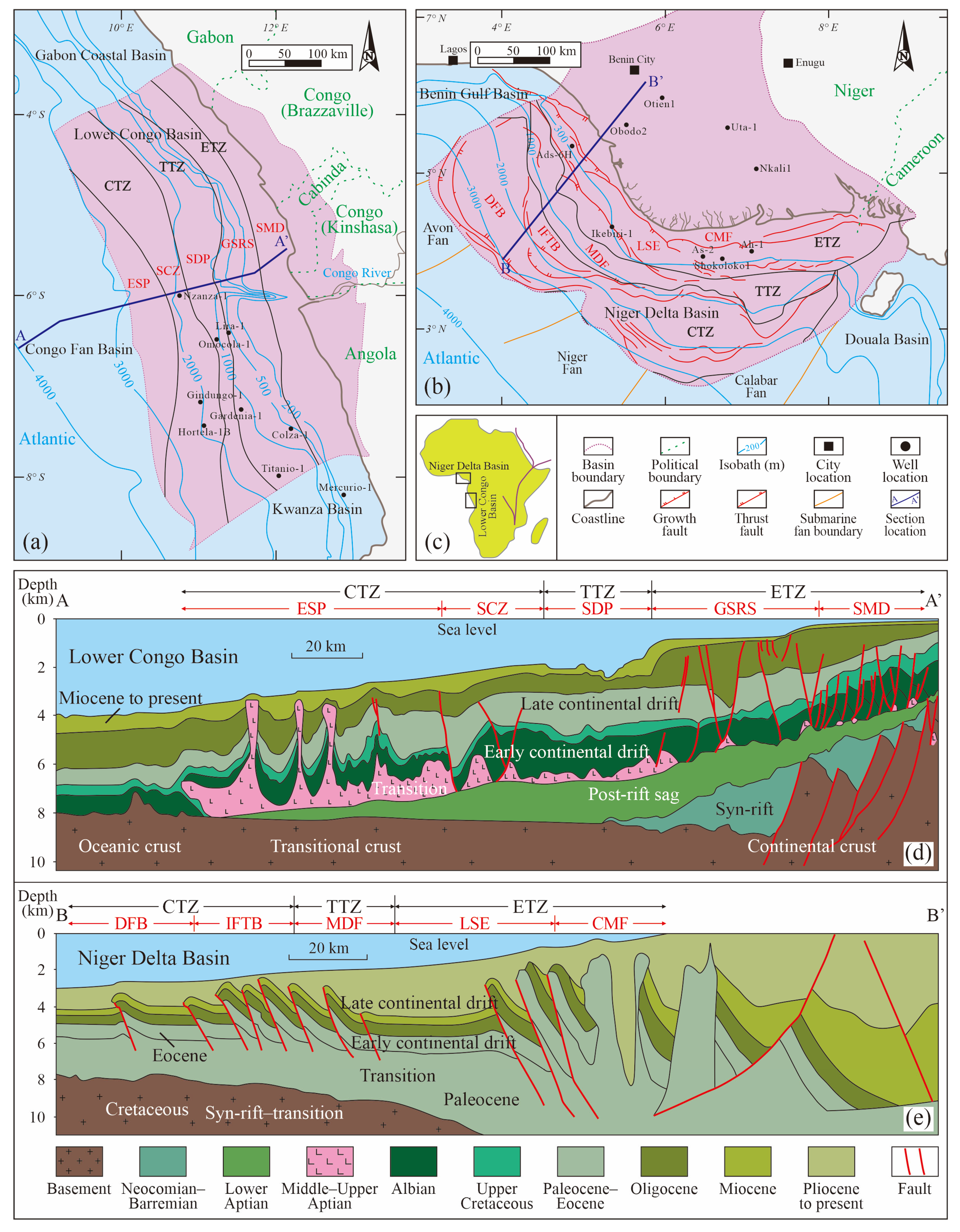
Figure 1. Location map (c), tectonic zonation, and structural cross-sections of the Lower Congo Basin (a,d) and the Niger Delta Basin (b,e) (modified from [16]). Abbreviations: CTZ, Compressional tectonic zone; TTZ, Transitional tectonic zone; ETZ, Extensional tectonic zone; ESP, Extensive salt province; SCZ, Salt canopy zone; SDP, Salt diapir province; GSRS, Giant salt raft system; SMD, Salt-raft mini-basin domain; DFB, Detachment fold belt; IFTB, Inner fold-and-thrust belt; MDF, Mud diapir field; LSE, Lower shoreface environment; CMF, Coastal marsh facies.
Jmse 13 01533 g001
Figure 2. Composite chronostratigraphic columns of the Lower Congo Basin (a) and the Niger Delta Basin (b) (modified from [16]).
Jmse 13 01533 g002
Figure 3. Ternary diagram classifying shelf-margin architectural styles using sediment supply, accommodation space, and climatic conditions as classification axes.
Jmse 13 01533 g003
Figure 4. Sequence stratigraphic division and depositional facies interpretation from wireline logs in well Nzanza-1, the Lower Congo Basin (a) and well Ikebiri-1, the Niger Delta Basin (b).
Jmse 13 01533 g004
Figure 5. Seismic profiles, log responses, and spatial stacking patterns of sedimentary architecture units in the Lower Congo Basin (a) and the Niger Delta Basin (b).
Jmse 13 01533 g005
Figure 6. Stacking architecture of channel-lobe complexes in the Lower Congo Basin (a,b) and the Niger Delta Basin (c,d).
Jmse 13 01533 g006
Figure 7. Tectonothermal evolution and gravity-driven deformation with sedimentation rate settings in the central (a) and equatorial (b) segments of West African passive margin basins.
Jmse 13 01533 g007
Figure 8. Evolutionary models of deep-water depositional systems during the late continental drift stage in the Lower Congo Basin (a) and the Niger Delta Basin (b).
Jmse 13 01533 g008
Figure 9. Eustatic curves along both South Atlantic margins and correlation of erosional phases in the two basins (the eustatic curves is referenced from [46]).
Jmse 13 01533 g009
Figure 10. Oligocene–Miocene drainage distribution and basement paleouplift in the Lower Congo Basin (a), with mud/salt-diapir sub-basin fill patterns (bd).
Jmse 13 01533 g010
Figure 11. Depositional characteristics at shelf margins of the Lower Congo Basin (a,b) and the Niger Delta Basin (c,d).
Jmse 13 01533 g011
Table 1. Comparison of shelf-margin structural and morphological parameters for the two basins.
Basin NameAgeStructural ParametersMorphological Parameters
Aa
(m)
P
(km)
T
(My)
Ra
(m/My)
Rp
(km/My)
Fc
(km2/My)
Ta
(°)
Curvature IndexE/C Ratio
Lower Congo BasinQuaternary629.015.32.5251.66.13.82.4Upstream channels dominate, decreasing seaward0.2~0.6/0.5
Pliocene750.529.32.7278.010.98.21.5NANA
569.6−22.0 b5.2109.5−4.22.4−1.5
Miocene515.4−15.717.729.1−0.90.5−1.91.1~1.5/1.20.8~1.6/1.3
1354.954.517.776.53.14.21.41.1~1.5/1.30.2~4.2/2.8
Oligocene705.328.910.865.32.71.91.41.4~1.6/1.50.5~0.6/0.6
Niger Delta BasinQuaternary525.99.21.3404.67.13.73.31.0~1.4/1.20.8~3.1/1.9
0.8~1.4/1.1
542.311.11.3417.28.54.62.81.4~2.5/1.8
324.05.30.7462.97.62.53.51.3~2.0/1.5
458.812.41.4327.78.84.12.1NA
Pliocene492.94.41.2410.83.71.46.3Co-occurrence of erosional braided channels and constructive lobe-channel complexes
329.910.71.2274.98.92.91.8
661.514.81.1601.413.58.92.6
501.210.51.1455.69.54.72.7
Notes: Definition of structural parameters: A—Depositional thickness at shelf margin; P—Progradation distance; Ra = A/T—Sedimentation rate; Rp = P/T—Progradation rate; Fc = Rp × A—Net sediment flux (cross-section); Ta = arctan (A/P)—Trajectory angle. Symbol annotations: a Average seismic velocity: 1600 m/s (sandstone-dominated strata); b Negative P and Rp values indicate retrogradation; Value range format: minimum–maximum/mean (e.g., 1.1~1.5/1.2)
Disclaimer/Publisher’s Note: The statements, opinions and data contained in all publications are solely those of the individual author(s) and contributor(s) and not of MDPI and/or the editor(s). MDPI and/or the editor(s) disclaim responsibility for any injury to people or property resulting from any ideas, methods, instructions or products referred to in the content.