Shallow-Water Submarine Landslide Susceptibility Map: The Example in a Sector of Capo d’Orlando Continental Margin (Southern Tyrrhenian Sea)
Abstract
1. Introduction
- (i).
- Which geological factors that can be extensively mapped have a preconditioning value for the formation of shallow-water landslides in the study area?
- (ii).
- What are the most favourable preconditioning conditions to promote shallow-water landslides?
- (iii).
- Which seafloor sectors are more susceptible to instability processes?
2. Geological, Climatic and Oceanographic Setting
3. Geomorphology of the Capo d’Orlando Continental Margin
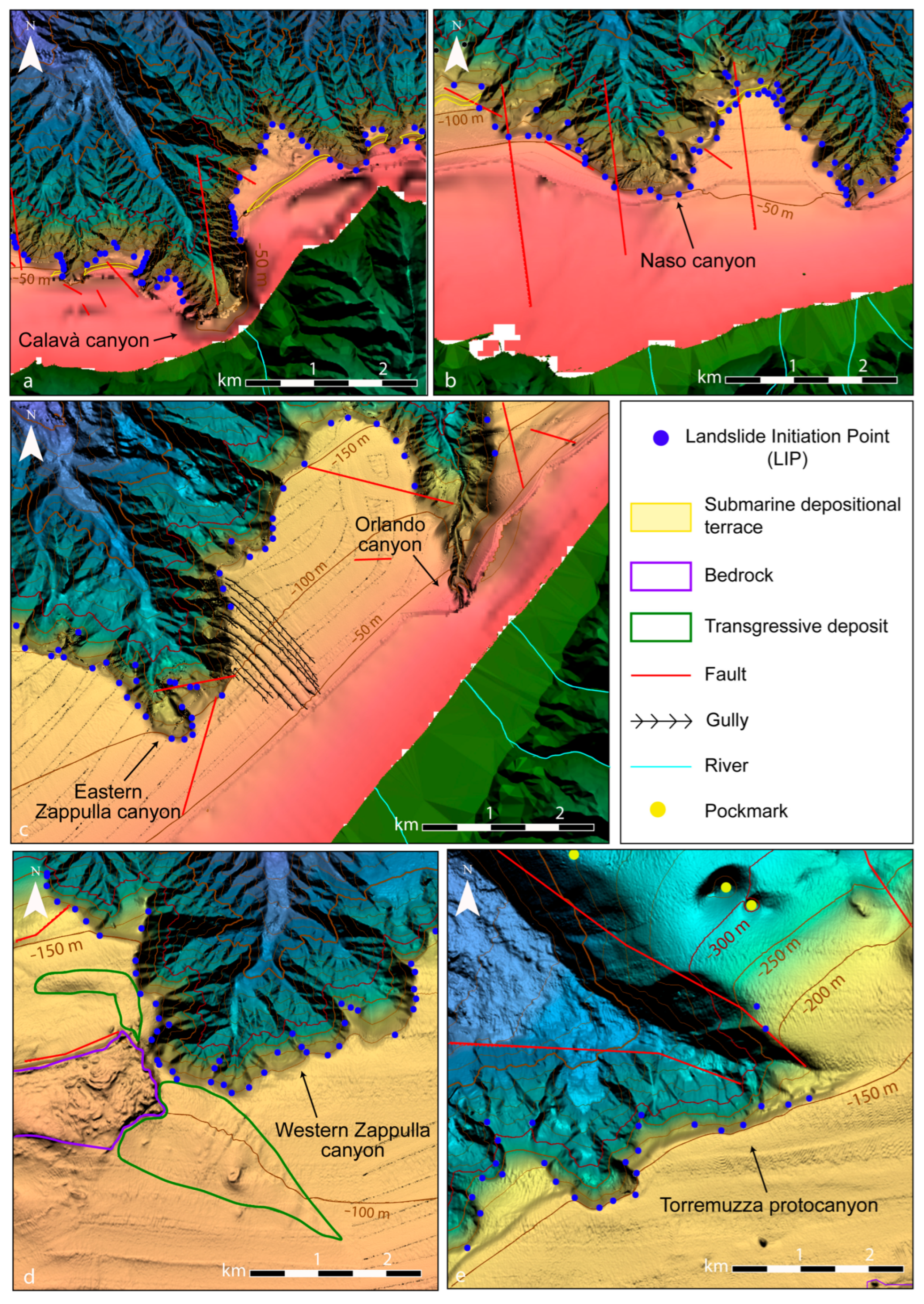
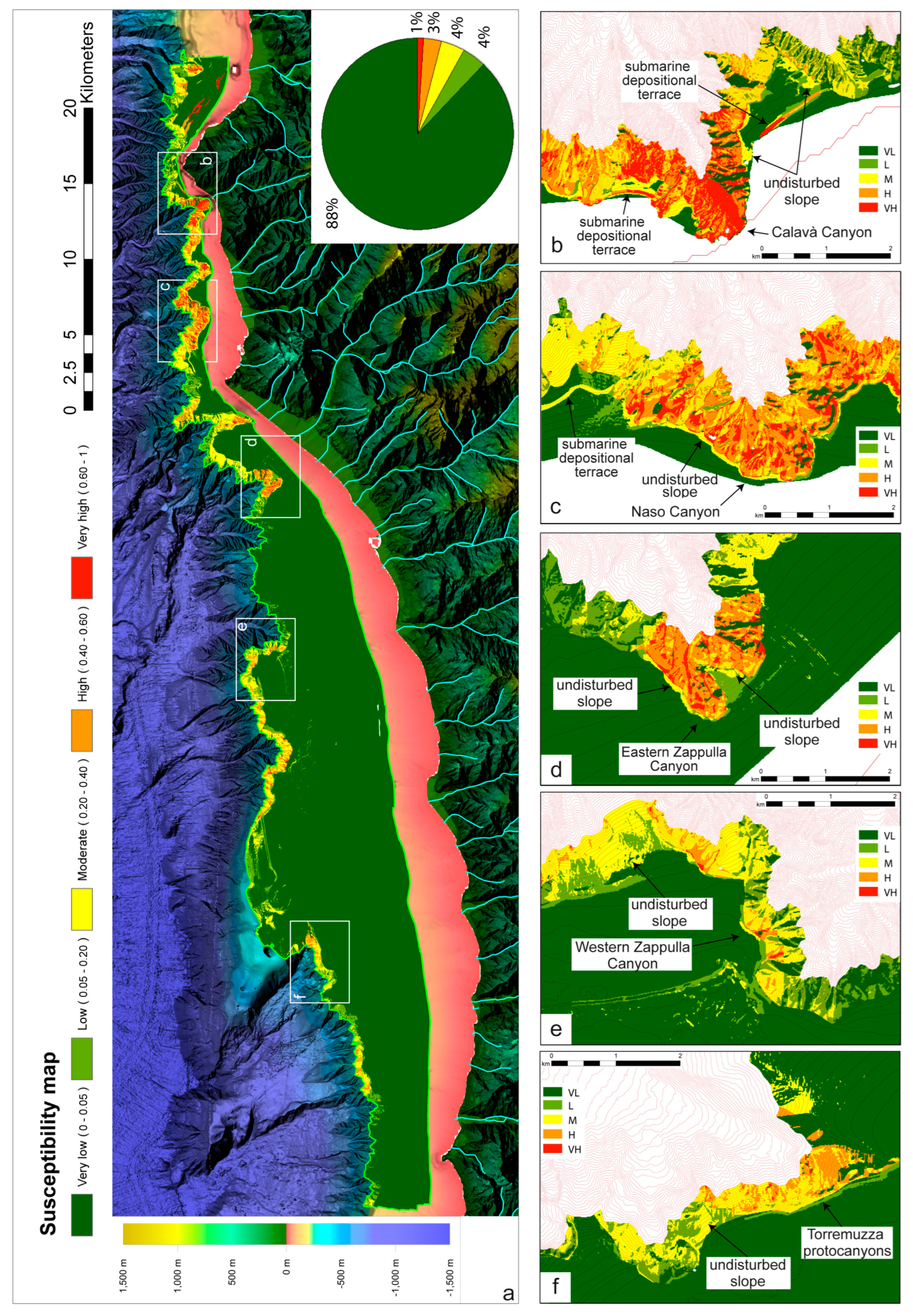
- Calavà canyon: Calavà canyon-head is a few tens of meters from the coast at 5 m of depth (Figure 2a) and is directly connected to a river [24,45]. In the continental shelf surrounding the Calavà canyon continuous steps created by the foresets of submarine depositional terraces (i.e., sand-rich prograding wedges) [46] are recognized at different depths, i.e., 30 and 50 m, and their lateral continuity is occasionally interrupted by canyon heads (Figure 2a,b) [47].
- Orlando canyon: Orlando canyon has its head at 30 m of depth, about 500 m from the coast and is directly connected to a river (Figure 2c). The Orlando canyon has a mixed alimentation, it is fed by river inputs and littoral drift flowing from W to E and carrying sediment-laden flows into the canyon [24].
- Naso Canyon: The canyon head is located at 2 km from the homonymous river mouth at a depth of 30 m, it is suggested to have its morphology controlled by a fault [24].
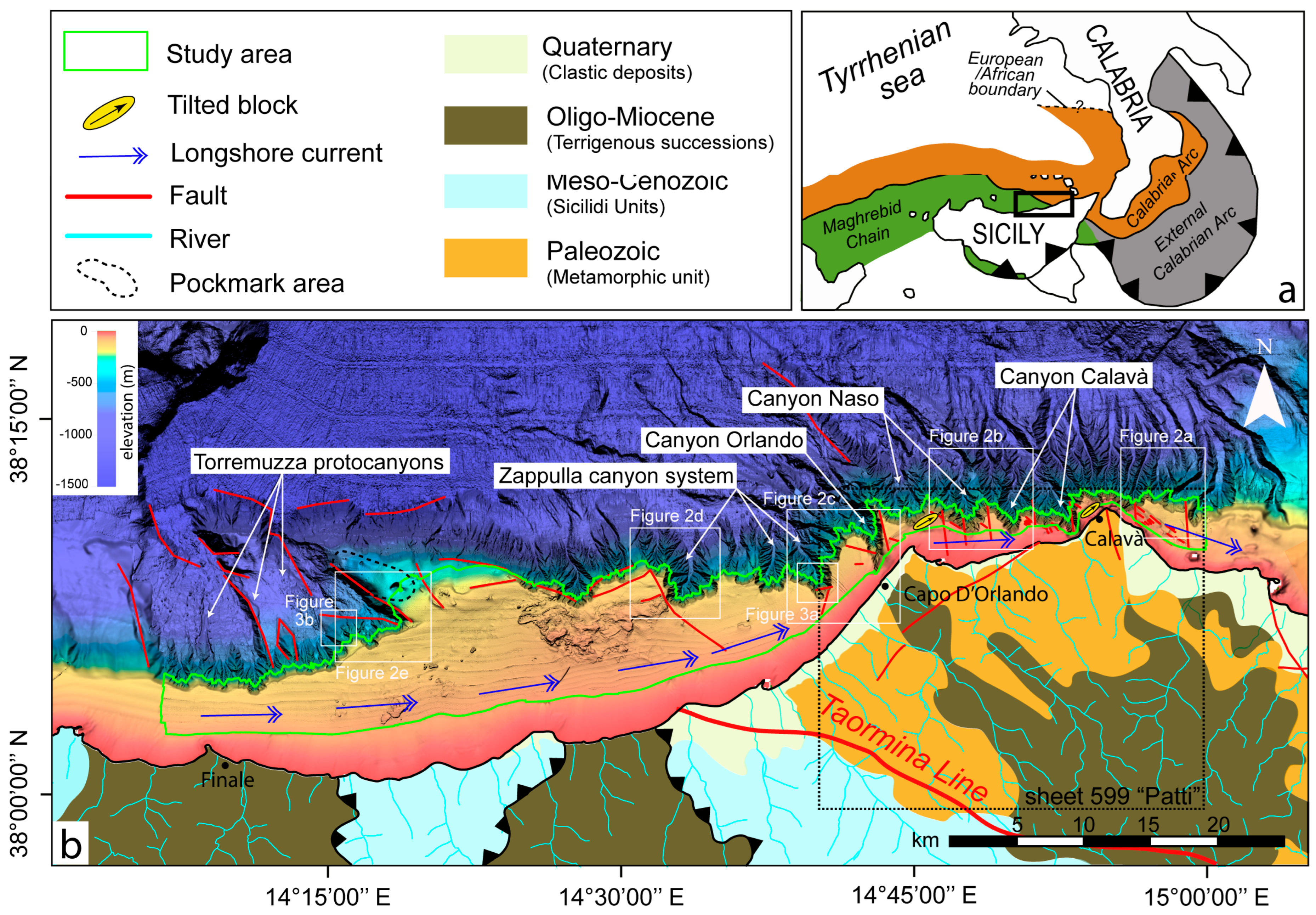
- Zappulla canyons: Three canyons make up the Zappulla canyon system (Figure 1). The easternmost Zappulla canyon is located 2 km from the coast at—75 m in front of a river mouth delivering sediment until the canyon head, as proved by the presence of gullies on the continental shelf (Figure 2c). The westernmost Zappulla canyon is located where the continental shelf is 10 km wide. Here, the canyon head indents the continental shelf at 100 m depth in front of a large outcropping bedrock (Figure 2d). In the area behind the canyon head, transgressive sandy deposits corresponding to deltas, bars, tombolos, and spits have been recognized (Figure 2d) [45]. To the west with respect to the Zappulla canyon, a triangular-shaped block is characterized by the presence of pockmarks aligned in a NW–SE direction (Figure 1b).
4. Materials and Methods
4.1. Geophysical and Landslides Dataset
4.2. Preconditioning Factors
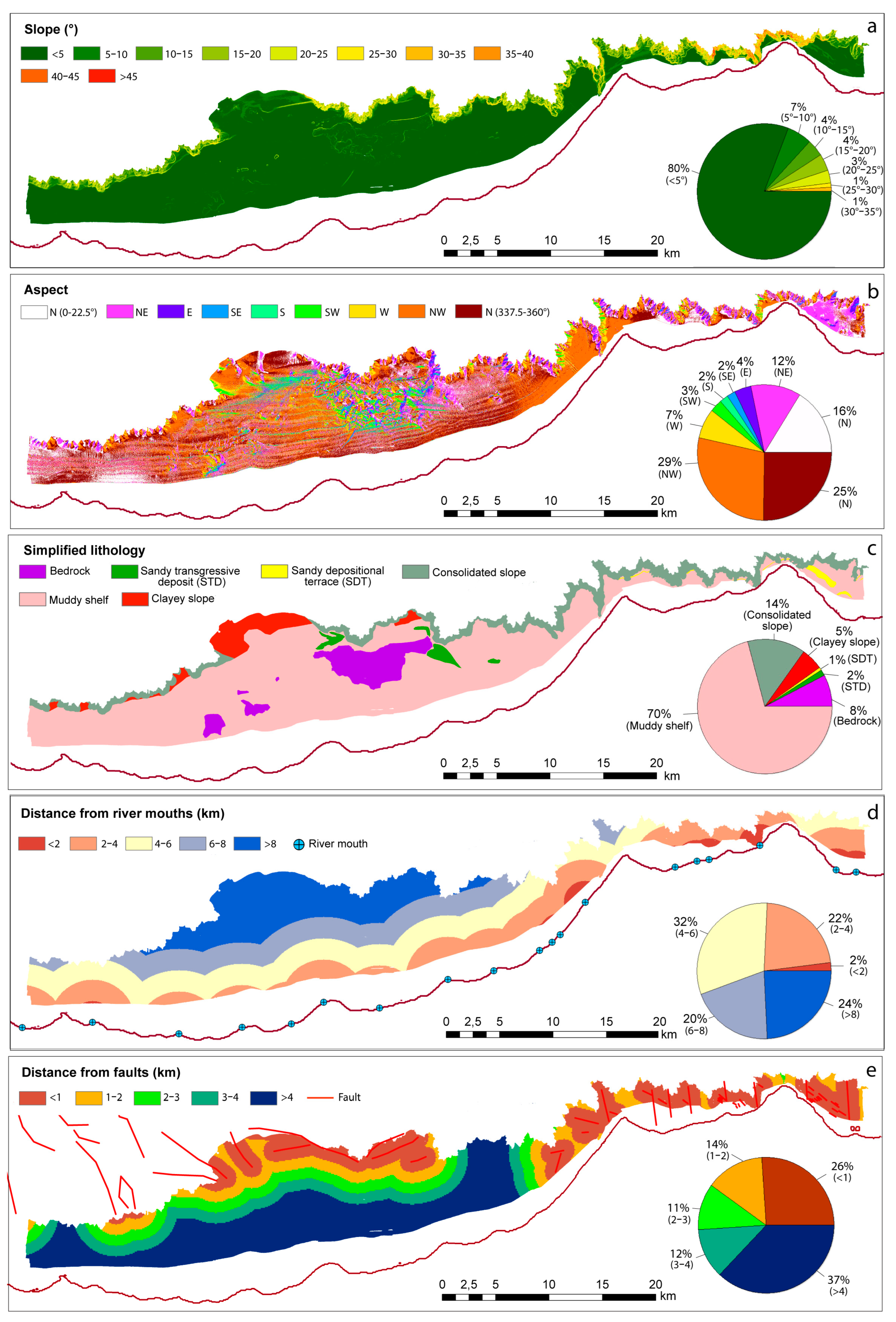
- Slope, surface steepness measured in degrees, is considered the most important factor affecting slope stability [52,53], since the driving force of mass movement increases with increasing slope. According to the literature, slope classes are commonly divided at intervals of 5° [52]; consequently our slope map is divided into ten classes from <5° to >45° (Figure 4a).
- Aspect indicates the compass direction that a slope faces, corresponding to the direction of the steepest slope at each point on the terrain surface [54]. In submarine environments, the aspect map can emphasize morphological differences controlled by the action of oriented water masses (e.g., wave action, longshore currents) that control the accumulation or the transport of sediment on the continental shelf and shelf-indented canyons. For this reason, the aspect map is considered in the analysis and is divided into 9 classes representing the slope directions generally used for landslide analysis [54] (Figure 4b).
- The Simplified lithological map has been produced in the study area assigned to the different depositional environments (i.e., continental shelf, slope); it deposits (i.e., depositional terraces, transgressive deposits) the lithology conventionally associated with them. This approach resulted in the recognition of a clayey slope, Consolidated slope, muddy shelf, sandy depositional terrace, sandy transgressive deposits, and bedrock (Figure 4c). Transgressive deposits have been extracted from [45], while the foresets’ extension of depositional terraces and outcropping bedrock from the MAGIC project [47]. The distinction of a consolidated slope relies on the presence of canyons deeply incised on the slope eroding and exposing older and presumably more consolidated sedimentary sequences (i.e., Noemi Unit) compared to late Quaternary depositional sequences characterizing the continental shelf.
- Distance from river mouths is considered a possible preconditioning factor for shallow-water landslides. Fiumare, the typical rivers of the study area, have a torrential regime and may experience flash flood events with high sediment/water ratio (>5–10%), which can exert important shear stress on the seafloor or rapidly deposit their sediment load increasing pore water pressure [55]. For this reason, the river-mouth distance map was extracted based on the Italian drainage network and divided into five classes with a 2 km interval (Figure 4d).
- Distance from faults is used to evaluate the importance of oversteepening of morphological fault steps able to form potential sliding surfaces, enabling detachments and downslope movements of sediment volumes. Faulting within the sedimentary column can also generate deformations in unconsolidated sediments and produce loose cataclastic debris within hard bedrocks forming weak layers that reduce overall slope stability. In our analysis, faults have been extrapolated from METIQ sheet 5 [56], sheet 599 “Patti” [35] and, in the western part of the Capo d’Orlando continental margin, through the interpretation of the available seismic profiles [57] (Figure 1b). The distances from the faults have been divided into five classes with 1 km intervals (Figure 4e).
4.3. Weight of Evidence (WoE) Method
5. Results
5.1. Preconditioning Factor Classes Distribution
5.2. Contrast Values of Preconditioning Factors Classes
5.3. Susceptibility Map
6. Discussion
6.1. Preconditioning Factors Influence on Slope Destabilization
6.2. From Landslide Susceptibility to Hazard Potential
6.3. Novelty and Criticalities
7. Conclusions
Author Contributions
Funding
Data Availability Statement
Acknowledgments
Conflicts of Interest
Abbreviations
| WoE | Weight of Evidence |
| LIP | Landslide Initiation Point |
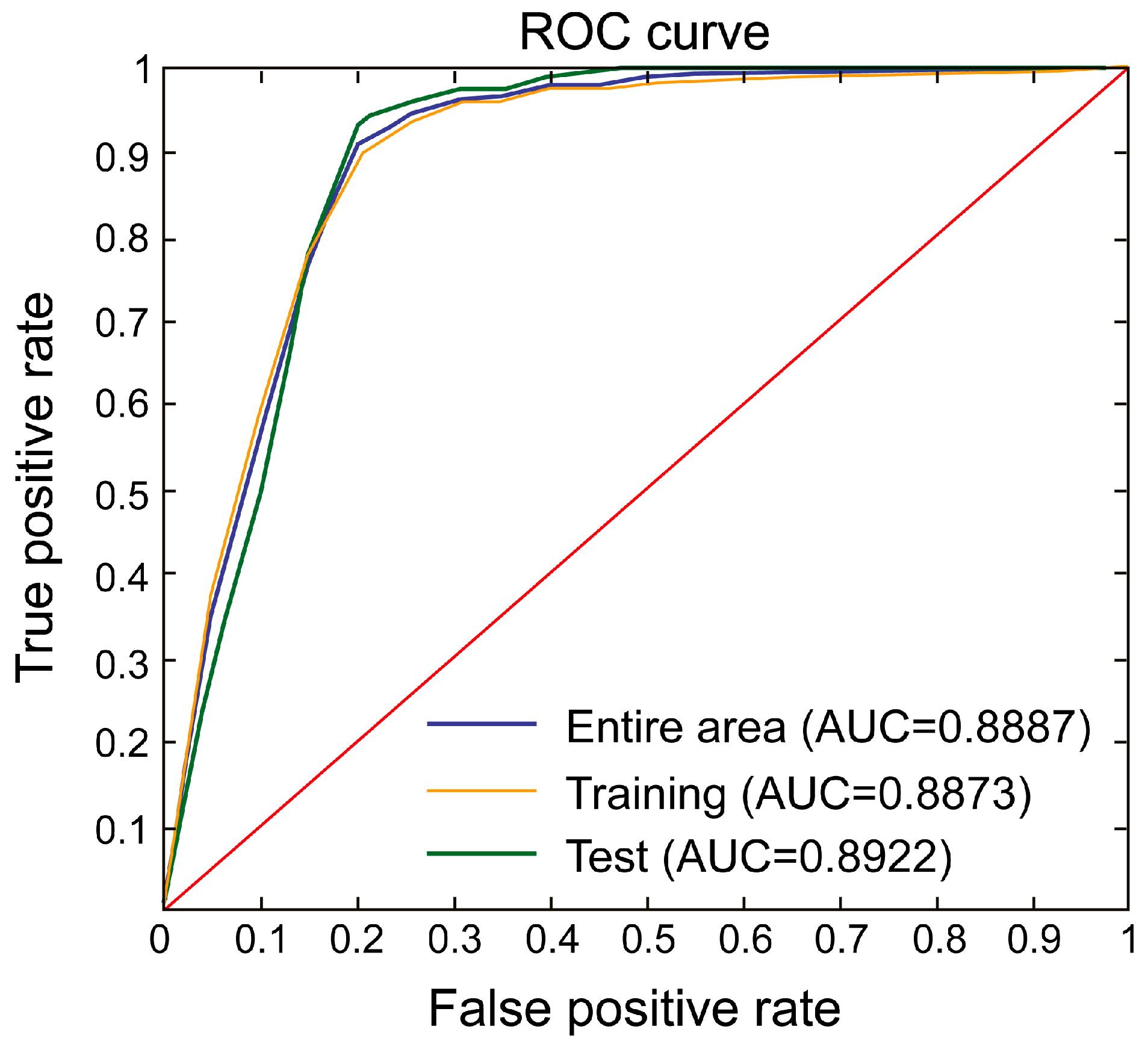
| ROC | Receiver Operating Characteristic |
| AUC | Area under the Curve |
References
- Masson, D.G.; Harbitz, C.B.; Wynn, R.B.; Pedersen, G.; Løvholt, F. Submarine Landslides: Processes, Triggers and Hazard Prediction. Philos. Trans. R. Soc. A Math. Phys. Eng. Sci. 2006, 364, 2009–2039. [Google Scholar] [CrossRef] [PubMed]
- Camerlenghi, A.; Urgeles, R.; Ercilla, G.; Brückmann, W. Scientific Ocean Drilling behind the Assessment of Geo-Hazards from Submarine Slides. Sci. Drill. 2007, 4, 45–47. [Google Scholar] [CrossRef]
- Talling, P.J.; Clare, M.; Urlaub, M.; Pope, E.; Hunt, J.E.; Watt, S.F.L. Large Submarine Landslides on Continental Slopes: Geohazards, Methane Release, and Climate Change. Oceanography 2014, 27, 32–45. [Google Scholar] [CrossRef]
- Chiocci, F.L.; Casalbore, D.; Falese, F.; Spatola, D.; Scacchia, E.; Bianchini, M. Marine Geohazards in Italy, Their Specificity and Mitigation Perspective. In Marine Hazards, Coastal Vulnerability, Risk (mis)Perceptions—A Mediterranean Perspective; CIESM Monographs 52; Briand, F., Ed.; CIESM Publisher: Paris, France; Monaco, France, 2024; pp. 73–88. [Google Scholar]
- Dan, G.; Sultan, N.; Savoye, B. The 1979 Nice Harbour Catastrophe Revisited: Trigger Mechanism Inferred from Geotechnical Measurements and Numerical Modelling. Mar. Geol. 2007, 245, 40–64. [Google Scholar] [CrossRef]
- Zaniboni, F.; Armigliato, A.; Pagnoni, G.; Tinti, S. Continental Margins as a Source of Tsunami Hazard: The 1977 Gioia Tauro (Italy) Landslide-Tsunami Investigated through Numerical Modeling. Mar. Geol. 2014, 357, 210–217. [Google Scholar] [CrossRef]
- Hughes Clarke, J.E.; Shor, A.N.; Piper, D.J.; Mayer, L.A. Large-scale Current-induced Erosion and Deposition in the Path of the 1929 Grand Banks Turbidity Current. Sedimentology 1990, 37, 613–629. [Google Scholar] [CrossRef]
- Pope, E.L.; Talling, P.J.; Carter, L. Which Earthquakes Trigger Damaging Submarine Mass Movements: Insights from a Global Record of Submarine Cable Breaks? Mar. Geol. 2017, 384, 131–146. [Google Scholar] [CrossRef]
- Colantoni, P.; Gennesseaux, M.; Vanney, J.R.; Ulzega, A.; Trombetta, A. Processi Dinamici Del Canyon Sottomarino de Gioia Tauro (Mare Tirreno). G. Geol. Ser. 3 1992, 54, 199–213. [Google Scholar]
- Mulder, T.; Cochonat, P. Classification of Offshore Mass Movements. J. Sediment. Res. 1996, 66, 43–57. [Google Scholar] [CrossRef]
- Locat, J.; Lee, H.J. Submarine Landslides: Advances and Challenges. Can. Geotech. J. 2002, 39, 193–212. [Google Scholar] [CrossRef]
- Lee, H.J.; Locat, J.; Desgagnés, P.; Parsons, J.D.; McAdoo, B.G.; Orange, D.L.; Puig, P.; Wong, F.L.; Dartnell, P.; Boulanger, E. Submarine Mass Movements on Continental Margins. In Continental Margin Sedimentation: From Sediment Transport to Sequence Stratigraphy; Wiley: New York, NY, USA, 2007; pp. 213–274. [Google Scholar] [CrossRef]
- Huhn, K.; Arroyo, M.; Cattaneo, A.; Clare, M.A.; Gràcia, E.; Harbitz, C.B.; Krastel, S.; Kopf, A.; Løvholt, F.; Rovere, M.; et al. Part II Submarine Landslide Deposits in Current Active and Passive Margins; John Wiley & Sons, Inc.: New York, NY, USA, 2019. [Google Scholar]
- Chaytor, J.D.; ten Brink, U.S.; Solow, A.R.; Andrews, B.D. Size Distribution of Submarine Landslides along the U.S. Atlantic Margin. Mar. Geol. 2009, 264, 16–27. [Google Scholar] [CrossRef]
- Casas, D.; Chiocci, F.; Casalbore, D.; Ercilla, G.; de Urbina, J.O. Magnitude-Frequency Distribution of Submarine Landslides in the Gioia Basin (Southern Tyrrhenian Sea). Geo-Marine Lett. 2016, 36, 405–414. [Google Scholar] [CrossRef]
- Casalbore, D.; Bosman, A.; Casas, D.; Chiocci, F.; Martorelli, E.; Ridente, D. Morphological Variability of Submarine Mass Movements in the Tectonically–Controlled Calabro–Tyrrhenian Continental Margin (Southern Italy). Geosciences 2019, 9, 43. [Google Scholar] [CrossRef]
- Urlaub, M.; Talling, P.J.; Masson, D.G. Timing and Frequency of Large Submarine Landslides: Implications for Understanding Triggers and Future Geohazard. Quat. Sci. Rev. 2013, 72, 63–82. [Google Scholar] [CrossRef]
- Kelner, M.; Migeon, S.; Tric, E.; Couboulex, F.; Dano, A.; Lebourg, T.; Taboada, A. Frequency and Triggering of Small-Scale Submarine Landslides on Decadal Timescales: Analysis of 4D Bathymetric Data from the Continental Slope Offshore Nice (France). Mar. Geol. 2016, 379, 281–297. [Google Scholar] [CrossRef]
- Biscara, L.; Hanquiez, V.; Leynaud, D.; Marieu, V.; Mulder, T.; Gallissaires, J.M.; Crespin, J.P.; Braccini, E.; Garlan, T. Submarine Slide Initiation and Evolution Offshore Pointe Odden, Gabon—Analysis from Annual Bathymetric Data (2004–2009). Mar. Geol. 2012, 299–302, 43–50. [Google Scholar] [CrossRef]
- Pratson, L.F.; Coakley, B.J. A Model for the Headward Erosion of Submarine Canyons Induced by Downslope-Eroding Sediment Flows. Bull. Geol. Soc. Am. 1996, 108, 225–234. [Google Scholar] [CrossRef]
- Micallef, A.; Mountjoy, J.J.; Canals, M.; Lastras, G. Deep-Seated Bedrock Landslides and Submarine Canyon Evolution in an Active Tectonic Margin: Cook Strait, New Zealand. In Submarine Mass Movements and Their Consequences. Advances in Natural and Technological Hazards Research; Springer: Berlin/Heidelberg, Germany, 2012; pp. 201–212. [Google Scholar] [CrossRef]
- Harishidayat, D.; Niyazi, Y.; Stewart, H.A.; Al-Shuhail, A.; Jamieson, A.J. Submarine Canyon Development Controlled by Slope Failure and Oceanographic Process Interactions. Sci. Rep. 2024, 14, 18486. [Google Scholar] [CrossRef] [PubMed]
- Shepard, F.P. Submarine Canyons: Multiple Causes and Long-Time Persistence. Am. Assoc. Pet. Geol. Bull. 1981, 65, 1062–1077. [Google Scholar] [CrossRef]
- Gamberi, F.; Rovere, M.; Marani, M.P.; Dykstra, M. Modern Submarine Canyon Feeder-System and Deep-Sea Fan Growth in a Tectonically Active Margin (Northern Sicily). Geosphere 2015, 11, 307–319. [Google Scholar] [CrossRef]
- Avdievitch, N.N.; Coe, J.A. Submarine Landslide Susceptibility Mapping in Recently Deglaciated Terrain, Glacier Bay, Alaska. Front. Earth Sci. 2022, 10, 821188. [Google Scholar] [CrossRef]
- Borrell, N.; Somoza, L.; León, R.; Medialdea, T.; Gonzalez, F.J.; Gimenez-Moreno, C.J. GIS Catalogue of Submarine Landslides in the Spanish Continental Shelf: Potential and Difficulties for Susceptibility Assessment. Adv. Nat. Technol. Hazards Res. 2016, 41, 499–508. [Google Scholar] [CrossRef]
- León, R.; Somoza, L. GIS-Based Mapping for Marine Geohazards in Seabed Fluid Leakage Areas (Gulf of Cadiz, Spain). Mar. Geophys. Res. 2011, 32, 207–223. [Google Scholar] [CrossRef]
- Tarazona, D.M.; Prieto, J.; Murphy, W.; Vesga, J.N.; Rincon, D.; Munoz, C.H.; Pinzon, H.M.; Mora, A.M.; Acuña-Uribe, M. Submarine Landslide Susceptibility Assessment along the Southern Convergent Margin of the Colombian Caribbean. Lead. Edge 2023, 42, 344–359. [Google Scholar] [CrossRef]
- Glade, T.; Crozier, M.J. The Nature of Landslide Hazard Impact. In Landslide Hazard Risk; Wiley: New York, NY, USA, 2005; pp. 41–74. [Google Scholar]
- Catalano, R.; Lo Cicero, G.; Sulli, A. Geology of Sicily: An Introduction. General Field Trip Guide. In Proceedings of the VI International Symposium on the Jurassic System, Palermo, Italy, 12–22 September 2002; pp. 12–22. Available online: https://www.pemberleybooks.com/product/geology-of-sicily-an-introduction.-general-field-trip-guide-vi-international-symposium-on-the-jurassic-system-palermo-italy-12-22-september-2002/26038/ (accessed on 13 July 2025).
- Kastens, K.A.; Mascle, J. The Geological Evolution of the Tyrrhenian Sea: An Introduction to the Scientific Results of ODP Leg 107. In Proceedings of the Ocean Drilling Program, 107 Scientific Results; Ocean Drilling Program: College Station, TX, USA, 1990; pp. 3–26. [Google Scholar] [CrossRef]
- Pepe, F.; Bertotti, G.; Cella, F.; Marsella, E. Rifted Margin Formation in the South Tyrrhenian Sea: A High-Resolution Seismic Profile across the North Sicily Passive Continental Margin. Tectonics 2000, 19, 241–257. [Google Scholar] [CrossRef]
- Pepe, F.; Sulli, A.; Agate, M.; Di Maio, D.; Kok, A.; Lo Iacono, C.; Catalano, R. Plio-Pleistocene Geological Evolution of the Northern Sicily Continental Margin (Southern Tyrrhenian Sea): New Insights from High-Resolution, Multi-Electrode Sparker Profiles. Geo-Marine Lett. 2003, 23, 53–63. [Google Scholar] [CrossRef]
- Milia, A.; Iannace, P.; Tesauro, M.; Torrente, M.M. Marsili and Cefalù Basins: The Evolution of a Rift System in the Southern Tyrrhenian Sea (Central Mediterranean). Glob. Planet. Change 2018, 171, 225–237. [Google Scholar] [CrossRef]
- Catalano, R.; Di Maio, D.; Sulli, A.; Analfino, A. Carta Geologica d’Italia Alla Scala 1:50.000 Del Foglio 599 “Patti (Settore Marino)”; ISPRA, Servizio Geologico d’Italia: Rome, Italy, 2013.
- Nigro, F.; Sulli, A. Plio-Pleistocene Extensional Tectonics in the Western Peloritani Area and Its Offshore (Northeastern Sicily). Tectonophysics 1995, 252, 295–305. [Google Scholar] [CrossRef]
- Billi, A.; Presti, D.; Orecchio, B.; Faccenna, C.; Neri, G. Incipient Extension along the Active Convergent Margin of Nubia in Sicily, Italy: Cefal-Etna Seismic Zone. Tectonics 2010, 29, 1–20. [Google Scholar] [CrossRef]
- Antonioli, F.; Ferranti, L.; Fontana, A.; Amorosi, A.; Bondesan, A.; Braitenberg, C.; Dutton, A.; Fontolan, G.; Furlani, S.; Lambeck, K.; et al. Holocene Relative Sea-Level Changes and Vertical Movements along the Italian and Istrian Coastlines. Quat. Int. 2009, 206, 102–133. [Google Scholar] [CrossRef]
- Ferranti, L.; Antonioli, F.; Mauz, B.; Amorosi, A.; Dai Pra, G.; Mastronuzzi, G.; Monaco, C.; Orrù, P.; Pappalardo, M.; Radtke, U.; et al. Markers of the Last Interglacial Sea-Level High Stand along the Coast of Italy: Tectonic Implications. Quat. Int. 2006, 145–146, 30–54. [Google Scholar] [CrossRef]
- Sulli, A.; Lo Presti, V.; Gasparo Morticelli, M.; Antonioli, F. Vertical Movements in NE Sicily and Its Offshore: Outcome of Tectonic Uplift during the Last 125 Ky. Quat. Int. 2013, 288, 168–182. [Google Scholar] [CrossRef]
- Menna, M.; Poulain, P.M.; Ciani, D.; Doglioli, A.; Notarstefano, G.; Gerin, R.; Rio, M.H.; Santoleri, R.; Gauci, A.; Drago, A. New Insights of the Sicily Channel and Southern Tyrrhenian Sea Variability. Water 2019, 11, 1355. [Google Scholar] [CrossRef]
- Spatola, D.; Sulli, A.; Casalbore, D.; Chiocci, F.L. First Evidence of Contourite Drifts in the North-Western Sicilian Active Continental Margin (Southern Tyrrhenian Sea). J. Mar. Sci. Eng. 2021, 9, 1043. [Google Scholar] [CrossRef]
- Marina, I.I. Della Atlante Della Correnti Superficiali Dei Mari Italiani; Istituto Idrografico della Marina: Genova, Italy, 1982.
- Lo Presti, V.; Antonioli, F.; Casalbore, D.; Chiocci, F.L.; Lanza, S.; Sulli, A.; Randazzo, G. Geohazard Assessment of the North-Eastern Sicily Continental Margin (SW Mediterranean): Coastal Erosion, Sea-Level Rise and Retrogressive Canyon Head Dynamics. Mar. Geophys. Res. 2022, 43, 1134385. [Google Scholar] [CrossRef]
- Gamberi, F. Systems Supplying Sediment to Canyon Heads (SSSCHs) in the Tyrrhenian Sea: The Past and the Present as a Key to Understanding Deep-Sea Stratigraphy. Mar. Pet. Geol. 2020, 119, 104470. [Google Scholar] [CrossRef]
- Casalbore, D.; Falese, F.; Martorelli, E.; Romagnoli, C.; Chiocci, F.L. Submarine Depositional Terraces in the Tyrrhenian Sea as a Proxy for Paleo-Sea Level Reconstruction: Problems and Perspective. Quat. Int. 2017, 439 Pt A, 169–180. [Google Scholar] [CrossRef]
- Gamberi, F.; Casalbore, D.; Marani, M.; Rovere, M.; Bosman, A.; Calarco, M.; Dalla Valle, G.; Leidi, E.; Martorelli, E.; Mercorella, A.; et al. Geohazard Features of the Aeolian Island Slopes and the North-Eastern Sicily Offshore. J. Maps 2024, 20, 2343314. [Google Scholar] [CrossRef]
- Casalbore, D.; Martorelli, E.; Bosman, A.; Morelli, E.; Chiocci, F.L. Failure Dynamics of Landslide Scars on the Lower Continental Slope of the Tyrrhenian Calabrian Margin: Insights from an Integrated Morpho-Bathymetric and Seismic Analysis. Geol. Soc. Spec. Publ. 2019, 477, 389–397. [Google Scholar] [CrossRef]
- Lombardo, L.; Cama, M.; Maerker, M.; Rotigliano, E. A Test of Transferability for Landslides Susceptibility Models under Extreme Climatic Events: Application to the Messina 2009 Disaster. Nat. Hazards 2014, 74, 1951–1989. [Google Scholar] [CrossRef]
- Esposito, C.; Mastrantoni, G.; Marmoni, G.M.; Antonielli, B.; Caprari, P.; Pica, A.; Schilirò, L.; Mazzanti, P.; Bozzano, F. From Theory to Practice: Optimisation of Available Information for Landslide Hazard Assessment in Rome Relying on Official, Fragmented Data Sources. Landslides 2023, 20, 2055–2073. [Google Scholar] [CrossRef]
- Martinello, C.; Delchiaro, M.; Iacobucci, G.; Cappadonia, C.; Rotigliano, E.; Piacentini, D. Exploring the Geomorphological Adequacy of the Landslide Susceptibility Maps: A Test for Different Types of Landslides in the Bidente River Basin (Northern Italy). Catena 2024, 238, 107835. [Google Scholar] [CrossRef]
- Çellek, S. Effect of the Slope Angle and Its Classification on Landslides. Himal. Geol. 2022, 43, 85–95. [Google Scholar]
- Yuvaraj, R.M.; Dolui, B. Geographical Assessment of Landslide Susceptibility Using Statistical Approach. Quat. Sci. Adv. 2023, 11, 100097. [Google Scholar] [CrossRef]
- Çellek, S. The Effect of Aspect on Landslide and Its Relationship with Other Parameters. In Landslides; IntechOpen: Rijeka, Croatia, 2022; p. 13. [Google Scholar]
- Casalbore, D.; Chiocci, F.L.; Mugnozza, G.S.; Tommasi, P.; Sposato, A. Flash-Flood Hyperpycnal Flows Generating Shallow-Water Landslides at Fiumara Mouths in Western Messina Strait (Italy). Mar. Geophys. Res. 2011, 32, 257–271. [Google Scholar] [CrossRef]
- METIQ Working Group Quaternary Map of Italy, Scale 1:500,000, 5 Sheets. Ed. by ISPRA, Draft Version Ed. INQUA Congr. Roma. 2023. Available online: https://sgi.isprambiente.it/metiq/METIQ_Explanatory_Note.pdf (accessed on 13 July 2025).
- Gamberi, F.; Scacchia, E.; Ferrante, V. Submarine Landslides, Debris Flows and Canyons: Processes of Slope Degradation and Shelf-Edge Indentation in a Tectonically Active Margin (Finale Basin, Northern Sicilian Margin, Tyrrhenian Sea). Front. Earth Sci. 2025; submitted. [Google Scholar]
- Bonham-Carter, G.F. Weights of Evidence Modelling: A New Approach to Mapping Mineral Potential. In Statistical Applications in the Earth Sciences; Geological Survey of Canada: Ottawa, ON, Canada, 1989; pp. 171–183. [Google Scholar]
- Sadisun, I.A.; Telaumbanua, J.A.; Kartiko, R.D.; Dinata, I.A. Pamela Weight of Evidence Method for Landslide Susceptibility Mapping in Sigi Biromaru, Central Sulawesi. IOP Conf. Ser. Earth Environ. Sci. 2021, 830, 7–13. [Google Scholar] [CrossRef]
- Bhandari, B.P.; Dhakal, S.; Tsou, C.Y. Assessing the Prediction Accuracy of Frequency Ratio, Weight of Evidence, Shannon Entropy, and Information Value Methods for Landslide Susceptibility in the Siwalik Hills of Nepal. Sustainability 2024, 16, 2092. [Google Scholar] [CrossRef]
- Berti, M.; Bertello, L.; Bernardi, A.R.; Caputo, G. Back Analysis of a Large Landslide in a Flysch Rock Mass. Landslides 2017, 14, 2041–2058. [Google Scholar] [CrossRef]
- Squarzoni, G.; Bayer, B.; Franceschini, S.; Simoni, A. Pre- and Post-Failure Dynamics of Landslides in the Northern Apennines Revealed by Space-Borne Synthetic Aperture Radar Interferometry (InSAR). Geomorphology 2020, 369, 107353. [Google Scholar] [CrossRef]
- Lapa, N.; Marques, F.M.F.S.; Rodrigues, A. Aveiro Canyon Head (Portugal) Submarine Slope Instability Assessment. Appl. Sci. 2020, 10, 9038. [Google Scholar] [CrossRef]
- De Melo, M.C.; Paquete, P.C.; Da Silva, M.M. Evolution of the Aveiro Cretaceous Aquifer (NW Portugal) During the Late Pleistocene and Present Day: Evidence from Chemical and Isotopic Data. In Palaeowaters in Coastal Europe: Evolution of Groundwater Since the Late Pleistocene; Special Publications; Edmunds, W.M., Milne, C.J., Eds.; Geological Society of London: London, UK, 2001; p. 189. [Google Scholar]
- Casalbore, D.; Romagnoli, C.; Adami, C.; Bosman, A.; Falese, F.; Ricchi, A.; Chiocci, F.L. Submarine Depositional Terraces at Salina Island (Southern Tyrrhenian Sea) and Implications on the Late-Quaternary Evolution of the Insular Shelf. Geoscience 2018, 8, 20. [Google Scholar] [CrossRef]
- Agate, M.; Infuso, S.; Lucido, M.; Mancuso, M. Submerged Depositional Terraces off the Carini Embayment (Northwestern Sicily). In Atlante dei Terrazzi Deposizionali Sommersi Lungo le Coste Italiane; Memorie Descrittive della Carta Geologica d’Italia; Chiocci, F.L., D’Angelo, S., Romagnoli, C., Eds.; Italian Institute for Environmental Protection and Research: Rome, Italy, 2004; Volume 58, pp. 66–68. [Google Scholar]
- Casalbore, D.; Bosman, A.; Chiocci, F.L. Study of Recent Small-Scale Landslides in Geologically Active Marine Areas Through Repeated Multibeam Surveys: Examples from the Southern Italy. In Submarine Mass Movements and Their Consequences. Advances in Natural and Technological Hazards Research; Springer: Berlin/Heidelberg, Germany, 2012; pp. 573–582. [Google Scholar] [CrossRef]
- Normark, W.R.; Piper, D.J.W.; Romans, B.W.; Covault, J.A.; Dartnell, P.; Sliter, R.W. Submarine Canyon and Fan Systems of the California Continental Borderland. Spec. Pap. Geol. Soc. Am. 2009, 454, 141–168. [Google Scholar] [CrossRef]
- Yoshikawa, S.; Nemoto, K. Seasonal Variations of Sediment Transport to a Canyon and Coastal Erosion along the Shimizu Coast, Suruga Bay, Japan. Mar. Geol. 2010, 271, 165–176. [Google Scholar] [CrossRef]
- Smith, M.E.; Werner, S.H.; Buscombe, D.; Finnegan, N.J.; Sumner, E.J.; Mueller, E.R. Seeking the Shore: Evidence for Active Submarine Canyon Head Incision Due to Coarse Sediment Supply and Focusing of Wave Energy. Geophys. Res. Lett. 2018, 45, 12403–12413. [Google Scholar] [CrossRef]
- Joerger, S.T.; Smith, M.E.; Buscombe, D.; Mueller, E.R. Evidence for Littoral Convergence and Sediment Delivery to Mattole Submarine Canyon, Northern California. Front. Earth Sci. 2024, 12, 1377997. [Google Scholar] [CrossRef]
- Bührig, L.H.; Colombera, L.; Patacci, M.; Mountney, N.P.; McCaffrey, W.D. Tectonic Influence on the Geomorphology of Submarine Canyons: Implications for Deep-Water Sedimentary Systems. Front. Earth Sci. 2022, 10, 836823. [Google Scholar] [CrossRef]
- Caruso, A.; Cosentino, C.; Pierre, C.; Sulli, A. Sea-Level Changes during the Last 41,000 Years in the Outer Shelf of the Southern Tyrrhenian Sea: Evidence from Benthic Foraminifera and Seismostratigraphic Analysis. Quat. Int. 2011, 232, 122–131. [Google Scholar] [CrossRef]
- Sulli, A.; Agate, M.; Mancuso, M.; Pepe, F.; Pennino, V.; Polizzi, S.; Presti, V.L.; Gargano, F.; Interbartolo, F. Variability of Depositional Setting along the North-Western Sicily Continental Shelf (Italy) during Late Quaternary: Effects of Sea Level Changes and Tectonic Evolution. Alp. Mediterr. Quat. 2012, 25, 141–155. [Google Scholar][Green Version]
- Kou, H.; Wang, Y.; Lu, J.; Yang, Y. Landslide Mechanism under Rapid Sedimentation in Shelf-Slope Break. Appl. Ocean Res. 2024, 153, 104242. [Google Scholar] [CrossRef]
- Kanamatsu, T.; Ashi, J.; Shiraishi, K. Controlling Factors of a Submarine Landslide on the Kumano-Nada Continental Slope, West Japan. Tectonophysics 2024, 883, 230370. [Google Scholar] [CrossRef]
- Ediger, V.; Okyar, M.; Ergin, M. Seismic Stratigraphy of the Fault-Controlled Submarine Canyon/Valley System on the Shelf and Upper Slope of Anamur Bay, Northeastern Mediterranean Sea. Mar. Geol. 1993, 115, 129–142. [Google Scholar] [CrossRef]
- Mountjoy, J.J.; Barnes, P.M.; Pettinga, J.R. Morphostructure and Evolution of Submarine Canyons across an Active Margin: Cook Strait Sector of the Hikurangi Margin, New Zealand. Mar. Geol. 2009, 260, 45–68. [Google Scholar] [CrossRef]
- Morelli, E.; Martorelli, E.; Casalbore, D.; Chiocci, F.L. Morpho-Stratigraphic Evolution of a Tectonically Controlled Canyon-Channel System in the Gioia Basin (Southern Tyrrhenian Sea). Mar. Geol. 2022, 451, 106881. [Google Scholar] [CrossRef]
- Jin, L.; Luan, X.; Raveendrasinghe, T.D.; Jiang, L.; Xue, Y.; Wei, X.; Ma, H. Influence of Sedimentary Processes and Fault Tectonics on the Evolution of Submarine Canyons in the East Andaman Basin: Insights from High-Resolution Seismic Data Analysis. Geomorphology 2024, 254, 109179. [Google Scholar] [CrossRef]
- Cabrera, C.; Puig, P.; Durán, R.; Fabri, M.C.; Guerin, C.; Lo Iacono, C.; Huvenne, V.A.I. Geomorphology and Evolution of the Blanes Canyon (NW Mediterranean). New Insights from High Resolution Mapping of Vertical Cliffs. Geomorphology 2024, 461, 109290. [Google Scholar] [CrossRef]
- Roger, J.H.; Bull, S.; Watson, S.J.; Mueller, C.; Hillman, J.I.; Wolter, A.; Davidson, S.A. A Review of Approaches for Submarine Landslide-Tsunami Hazard Identification and Assessment. Mar. Pet. Geol. 2024, 162, 106729. [Google Scholar] [CrossRef]
- McAdoo, B.G.; Pratson, L.F.; Orange, D.L. Submarine Landslide Geomorphology, US Continental Slope. Mar. Geol. 2000, 169, 103–136. [Google Scholar] [CrossRef]
- Hühnerbach, V.; Masson, D.G. Landslides in the North Atlantic and Its Adjacent Seas: An Analysis of Their Morphology, Setting and Behaviour. Mar. Geol. 2004, 213, 343–362. [Google Scholar] [CrossRef]
- Rovida, A.; Locati, M.; Camassi, R.; Lolli, B.; Gasperini, P. The Italian Earthquake Catalogue CPTI15. Bull. Earthq. Eng. 2020, 18, 2953–2984. [Google Scholar] [CrossRef]
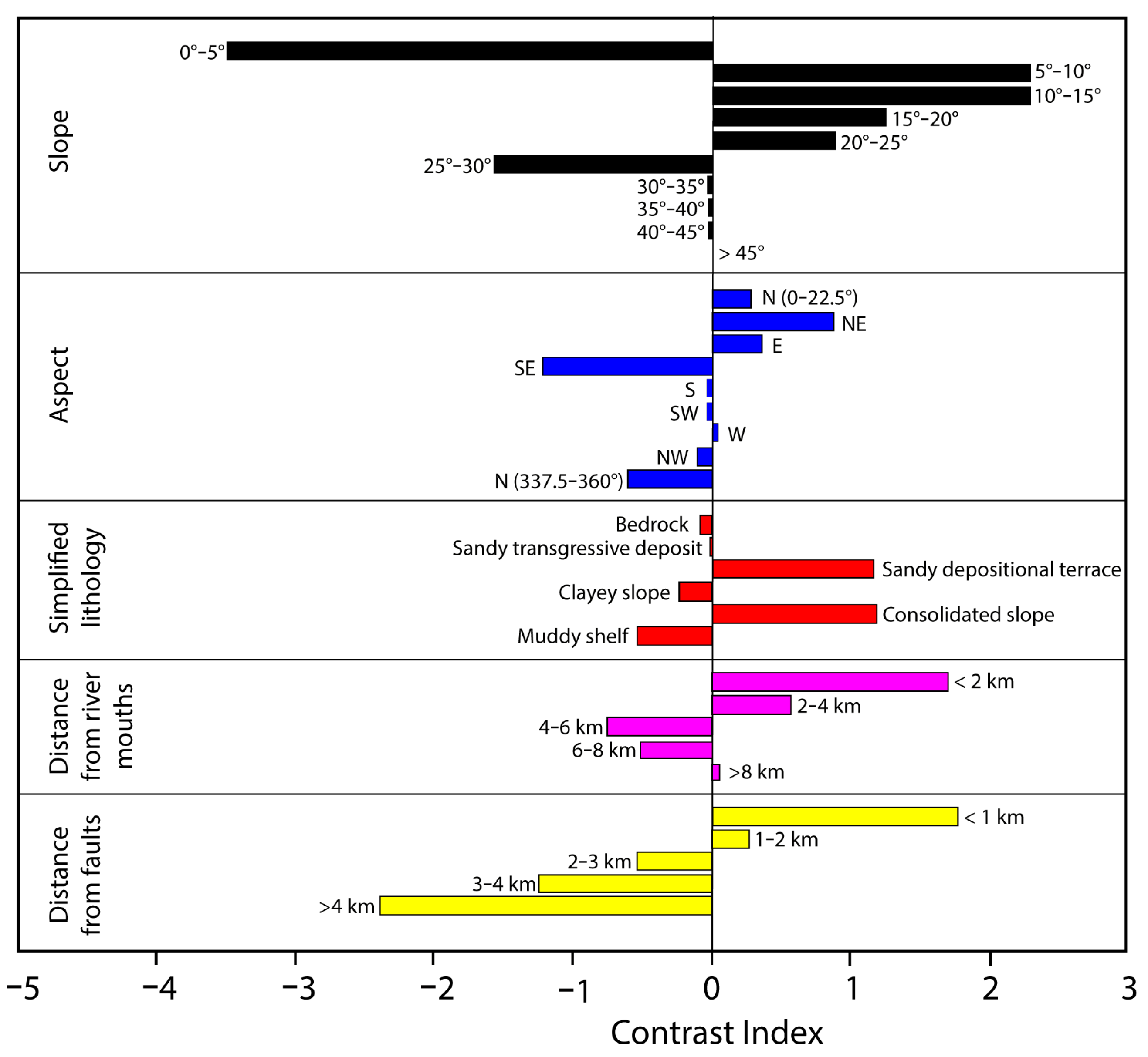
| Variable (Unit) | Class | Description/Numerical Interval | W+ | W− | C |
|---|---|---|---|---|---|
| Slope (degree) | 1 | <5 | −2.016 | 1.491 | −3.507 |
| 2 | 5–10 | 1.857 | −0.446 | 2.303 | |
| 3 | 10–15 | 1.986 | −0.319 | 2.305 | |
| 4 | 15–20 | 1.148 | −0.091 | 1.239 | |
| 5 | 20–25 | 0.847 | −0.037 | 0.883 | |
| 6 | 25–30 | −1.557 | 0.012 | −1.569 | |
| 7 | 30–35 | 0.000 | 0.009 | −0.009 | |
| 8 | 35–40 | 0.000 | 0.004 | −0.004 | |
| 9 | 40–45 | 0.000 | 0.001 | −0.001 | |
| 10 | >45 | 0.000 | 0.001 | −0.001 | |
| Aspect (degree) | N | >22.5 | 0.227 | −0.052 | 0.279 |
| NE | 22.5–67.5 | 0.724 | −0.152 | 0.876 | |
| E | 67.5–112.5 | 0.343 | −0.018 | 0.360 | |
| SE | 112.5–157.5 | −1.207 | 0.015 | −1.223 | |
| S | 157.5–202.5 | 0.000 | 0.022 | −0.022 | |
| SW | 202.5–247.5 | 0.000 | 0.033 | −0.033 | |
| W | 247.5–292.5 | 0.043 | −0.003 | 0.047 | |
| NW | 292.5–337.5 | −0.080 | 0.029 | −0.109 | |
| N | 337.5–360 | −0.488 | 0.122 | −0.610 | |
| Simplified lithological map | 1 | Bedrock | 0.000 | 0.079 | −0.079 |
| 2 | Sandy transgressive deposit | 0.000 | 0.015 | −0.015 | |
| 3 | Sandy depositional terraces | 1.161 | −0.013 | 1.174 | |
| 4 | Clayey slope | −0.226 | 0.011 | −0.238 | |
| 5 | Consolidated slope | 0.921 | −0.279 | 1.200 | |
| 6 | Muddy shelf | −0.187 | 0.352 | −0.540 | |
| Distance from river mouths (km) | 1 | <2 | 1.620 | −0.091 | 1.711 |
| 2 | 2–4 | 0.410 | −0.157 | 0.566 | |
| 3 | 4–6 | −0.582 | 0.182 | −0.764 | |
| 4 | 6–8 | −0.434 | 0.086 | −0.520 | |
| 5 | >8 | 0.042 | −0.014 | 0.056 | |
| Distance from faults (km) | 1 | <1 | 0.975 | −0.803 | 1.778 |
| 2 | 1–2 | 0.234 | −0.043 | 0.277 | |
| 3 | 2–3 | −0.486 | 0.047 | −0.532 | |
| 4 | 3–4 | −1.168 | 0.093 | −1.262 | |
| 5 | >4 | −1.982 | 0.416 | −2.398 |
Disclaimer/Publisher’s Note: The statements, opinions and data contained in all publications are solely those of the individual author(s) and contributor(s) and not of MDPI and/or the editor(s). MDPI and/or the editor(s) disclaim responsibility for any injury to people or property resulting from any ideas, methods, instructions or products referred to in the content. |
© 2025 by the authors. Licensee MDPI, Basel, Switzerland. This article is an open access article distributed under the terms and conditions of the Creative Commons Attribution (CC BY) license (https://creativecommons.org/licenses/by/4.0/).
Share and Cite
Scacchia, E.; Casalbore, D.; Gamberi, F.; Spatola, D.; Bianchini, M.; Chiocci, F.L. Shallow-Water Submarine Landslide Susceptibility Map: The Example in a Sector of Capo d’Orlando Continental Margin (Southern Tyrrhenian Sea). J. Mar. Sci. Eng. 2025, 13, 1350. https://doi.org/10.3390/jmse13071350
Scacchia E, Casalbore D, Gamberi F, Spatola D, Bianchini M, Chiocci FL. Shallow-Water Submarine Landslide Susceptibility Map: The Example in a Sector of Capo d’Orlando Continental Margin (Southern Tyrrhenian Sea). Journal of Marine Science and Engineering. 2025; 13(7):1350. https://doi.org/10.3390/jmse13071350
Chicago/Turabian StyleScacchia, Elena, Daniele Casalbore, Fabiano Gamberi, Daniele Spatola, Marco Bianchini, and Francesco Latino Chiocci. 2025. "Shallow-Water Submarine Landslide Susceptibility Map: The Example in a Sector of Capo d’Orlando Continental Margin (Southern Tyrrhenian Sea)" Journal of Marine Science and Engineering 13, no. 7: 1350. https://doi.org/10.3390/jmse13071350
APA StyleScacchia, E., Casalbore, D., Gamberi, F., Spatola, D., Bianchini, M., & Chiocci, F. L. (2025). Shallow-Water Submarine Landslide Susceptibility Map: The Example in a Sector of Capo d’Orlando Continental Margin (Southern Tyrrhenian Sea). Journal of Marine Science and Engineering, 13(7), 1350. https://doi.org/10.3390/jmse13071350


