Opinion

Early Perspectives on the Planned Brazilian Program to Address Ship-Sourced Pollution

by
Daniel Constantino Zacharias
1,* and
Angelo Teixeira Lemos
2
1
Institute of Astronomy, Geophysics and Atmospheric Sciences, University of Sao Paulo, Sao Paulo 05508-090, Brazil
2
Environmental Sciences Center, Federal University of Southern Bahia, Itabuna 45600-923, Brazil
*
Author to whom correspondence should be addressed.
J. Mar. Sci. Eng. 2025, 13(7), 1201; https://doi.org/10.3390/jmse13071201
Submission received: 13 May 2025 / Revised: 12 June 2025 / Accepted: 18 June 2025 / Published: 20 June 2025
(This article belongs to the Section Marine Pollution)

Abstract

:
A new integrated multi-user monitoring system for Brazilian Jurisdictional Waters (BJW), developed by Instituto Nacional de Pesquisas Espaciais (INPE) with participation from leading universities and research centers in Brazil, proposes a national approach to address oil spills in the South Atlantic. The system incorporates a range of technologies, such as satellite data, AI algorithms, autonomous sensors, and high-resolution modeling, to detect and respond to oil spills and maritime threats. This initiative not only aims to strengthen Brazil’s readiness to address the oil spills but also contribute to the protection of BJW resources and ecosystems. This opinion paper presents third-party viewpoints on SisMOM, analyzing both the positive and negative aspects of the project. It also explores some expectations for SisMOM, including some main and alternative methodologies. This article only reflects the authors’ perspectives, interpretations, points of view, opinions, and discussions about SisMOM’s propositions. This paper does NOT represent an official communication of the program, nor its methodologies and developments.

1. Introduction

In late August 2019, Brazil experienced one of the most extensive oil spill events to ever impact its coastal environment. Over the course of several months, vast quantities of tar balls reached more than 3000 km of shoreline, affecting eleven states along the Equatorial and Atlantic boards. The event was marked by a unique characteristic: the absence of an identified source in the immediate aftermath. No maritime accidents were reported, and the oil appeared suddenly and persistently, contaminating beaches, mangroves, and marine ecosystems. This “Mysterious” oil spill incident underscored the vulnerability of Brazil’s jurisdictional waters [1,2,3].
This environmental disaster prompted a wide mobilization effort involving local communities, governmental agencies, and independent researchers. The response was hampered by delayed detection, lack of predictive tools, and limited preparedness for an event of such spatial scale and uncertain origin. The incident underscored critical gaps in national oil spill monitoring frameworks and raised broader questions about the surveillance and governance of maritime traffic in Brazilian jurisdictional waters [1,2,3].
The institutional response to the oil spill was widely regarded as delayed and poorly coordinated. In the critical weeks following the first reports of contamination along the coast, the absence of clear leadership and the slow mobilization of federal resources revealed the vulnerability of Brazil’s governmental structure in dealing with large-scale environmental emergencies. Small-scale fishers and traditional populations were particularly affected, facing significant economic losses and health risks without immediate governmental support or protective policies [4,5,6].
In the face of this partial state inaction, civil society took the lead in the initial containment and cleanup efforts. Thousands of volunteers spontaneously organized beach cleanups, often without proper equipment or protective gear. Universities, NGOs, and local collectives contributed by providing technical analyses, mapping efforts, and logistical support. This combination of institutional fragility and civic resilience highlighted the urgent need to strengthen Brazil’s preparedness and response mechanisms for environmental disasters. As a direct consequence of the lessons learned from the 2019 event, new initiatives emerged to develop integrated systems for the forecasting, monitoring, and response to marine oil spills. These ongoing efforts aim to enhance marine environmental governance and reduce the impact of future accidents within Brazilian jurisdictional waters [7,8,9].
Since the 2019 “Mysterious” oil spill, at least two more significant pollution incidents caused by ships have been recorded in ecological sanctuaries along the Ceará coast and within the Fernando de Noronha archipelago [10,11,12]. Moreover, large-scale probabilistic modeling estimated that up to 30% of ships on route through the South Atlantic may be exploiting the lack of international surveillance to dump waste and oil close to BJW [13,14]. Brazil’s history of oil spills shows a significant reduction in accidents following the implementation of a new environmental protection legislation on 28 April 2000. However, the number of intentional spills (dumping) has increased over the last 5 years, highlighting the need for a more effective oil spill monitoring and response system [1]. In response, the investment in a new program for oil spill monitoring and modeling (SisMOM: Sistema Multiusuário de detecção, previsão e monitoramento de derrame de Óleo no Mar; i.e., Multi-user System for Offshore Oil Spill Detection, Forecast, and Monitoring) marks a pivotal development in safeguarding Brazil’s coastline against oil pollution [15,16].
SisMOM is the integrated, multi-user monitoring system for BJW, which utilizes space technologies, autonomous vehicles, moored buoys, atmospheric and oceanic models, and artificial intelligence techniques. Instituto Nacional de Pesquisas Espaciais (INPE, i.e., National Institute for Space Research) coordinates the project’s development with the participation of leading universities and research centers in Brazil [15,16]. The public contract was registered under the Agreement for Research, Development and Innovation number 01.22.0102.00, reference 1576/21, signed between the Financiadora de Estudos e Projetos1 (FINEP), the Fundação de Ciência, Aplicações e Tecnologia Espaciais2 (FUNCATE), the Instituto Nacional de Pesquisas Espaciais (INPE), and the Ministério da Ciência, Tecnologia e Inovação3 (MCTI) [17].
This perspective paper presents third-party viewpoints on SisMOM, analyzing both the positive and negative aspects of the project. It also explores the expectations for SisMOM in the coming years.

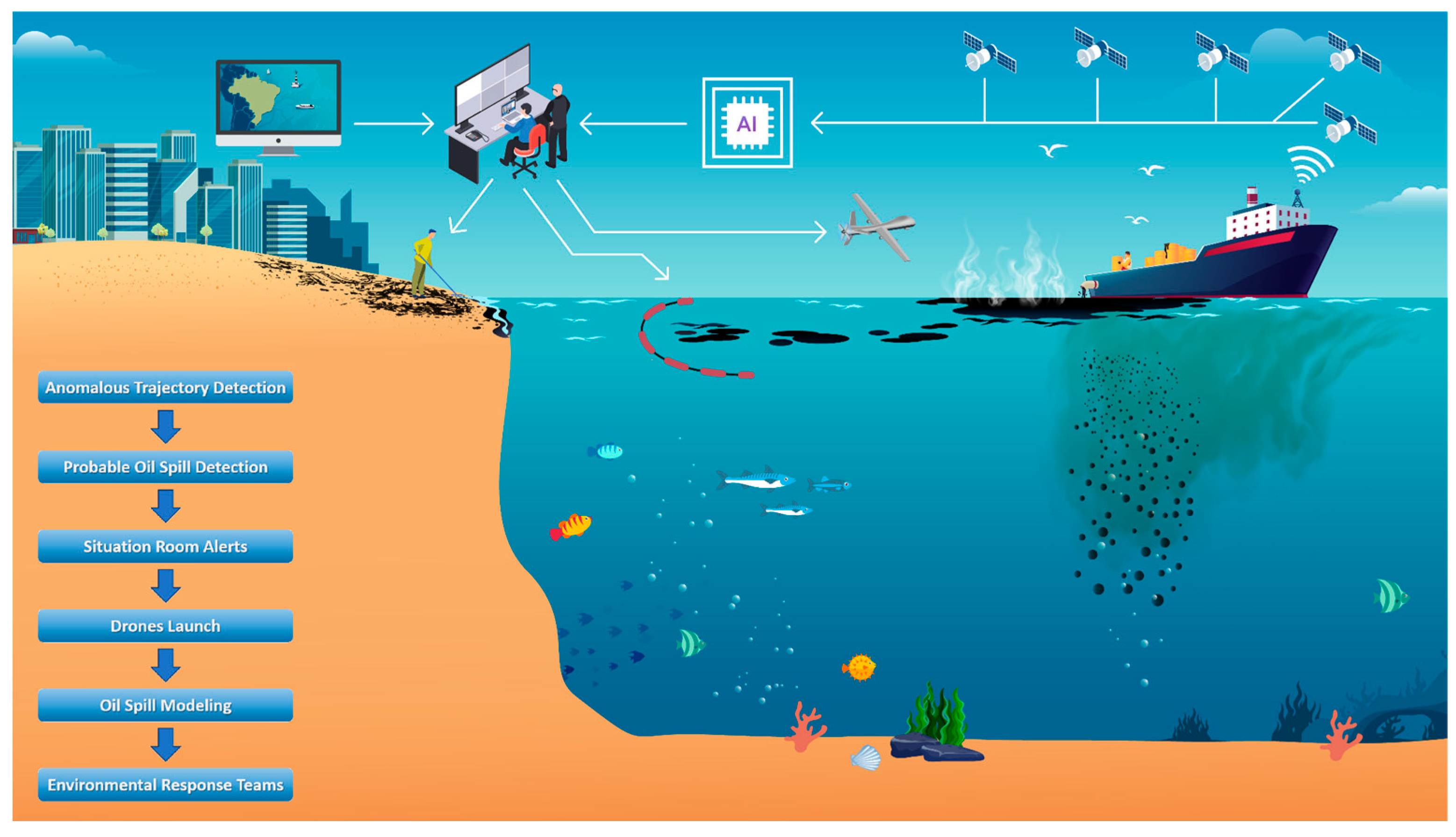
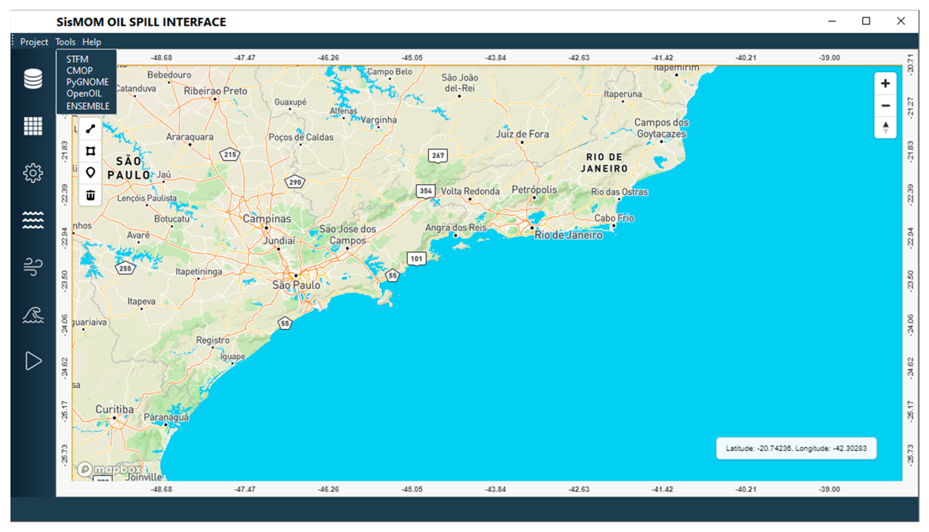
2. Project Description

SisMOM is a multidisciplinary and inter-institutional system that integrates operational oceanographic and meteorological forecasting models with remote sensing, data assimilation, and artificial intelligence components. Its architecture allows multiple government agencies, including environmental, defense, and emergency response sectors, to access real-time information and collaborate effectively in managing oil spill incidents. The system combines deterministic and probabilistic modeling tools for oil dispersion and weathering, facilitating scenario analysis and impact assessment. One of its core innovations is the incorporation of high-resolution numerical simulations and adaptive learning algorithms, which enable more accurate predictions of oil drift under complex oceanographic conditions [15,16,17].
The system is structured around a modular and scalable framework that integrates various components for real-time data acquisition, atmospheric and oceanic forecasting, oil spill modeling, and user interaction. The system relies heavily on high-performance computing infrastructure to support the execution of atmosphere and oceanic models, such as the ETA model [18] (http://etamodel.cptec.inpe.br/, accessed on 15 June 2025), widely used by INPE for atmospheric dynamics, and the Modular Ocean Model (MOM6) [19] and TELEMAC for regional and coastal circulation [20].
SisMOM is structured around nine goals that focus mainly on detecting vessels and oil slicks at sea, as well as predicting oil drift and dispersion. The monitoring system will be equipped to identify suspicious vessel behavior using artificial intelligence algorithms that analyze Automatic Identification System (AIS) and high-frequency radio wave data and detect potential oil slicks through high-resolution satellite imagery. High-resolution atmospheric and oceanographic data will be assimilated to run oil spill dispersion models, estimating the probability of oil slicks and tar balls reaching the shore. This data will provide critical information to response teams (Figure 1).
The project also includes a data assimilation layer that integrates satellite remote sensing, AIS (Automatic Identification System) ship tracking data, and in situ observations from buoys and coastal stations. Another key feature is the multi-user decision support interface (Situation Room), designed for interoperability across institutions. The Situation Room integrates live data from satellites, weather stations, and ocean sensors to track environmental changes and support coordinated emergency responses.
Thus, SisMOM is structured in a sequence of integrated levels, ranging from the identification of potential polluters to supporting government actions led by the Instituto Brasileiro do Meio Ambiente e dos Recursos Naturais Renováveis4 (IBAMA), Marinha5 do Brasil (MB), and the Ministério Público6 (MP), following what was established by the National Contingency Plan for Oil Pollution Incidents in Waters under National Jurisdiction (PNC)7, established by Federal Decree 10.950/2022.
The development of the SisMOM is organized around nine distinct goals, and each one is segmented into independent working groups. As a result, not all technical details and methodological choices are fully accessible at this time. Several components of the system involve sensitive information that remains protected for strategic and institutional reasons. Furthermore, many procedures and tools are still under refinement, given the current stage of project implementation. In light of these constraints, some analyses presented in this work are supported primarily by literature reviews and established methodologies available in the scientific domain, rather than by finalized operational data from the system itself.
The project design is subdivided into nine complementary goals.
Goal 1—automatic detection of ships at sea
This goal focuses on training artificial intelligence (AI) algorithms to analyze satellite images and auxiliary data, such as Radio Frequency (RF) signals and AIS signatures, to identify the presence, position, and anomalous movements of vessels.
The integration of AI in detecting unusual ship trajectories is crucial for combating illegal oil spills, especially during nighttime operations when satellite-based oil detection is more challenging [21]. Vessels involved in illicit activities often use tactics such as applying dispersants, disabling AIS, altering routes, and operating under the cover of rain or darkness to evade detection [22,23].
Among the available technologies for maritime surveillance, the multi-channel Synthetic Aperture Radar (SAR) has emerged as one of the most effective and sophisticated techniques for monitoring vessel activities at sea. The usual approaches consist of two steps: (1) selection of the target in SAR images of busy traffic, which corresponds to Automatic Identification System (AIS) signals by the “dead-reckoning (DR) position”, and (2) estimation of the position, size, and speed of the ship from SAR images and comparison these results with the AIS “true” data [24,25].
Despite the effectiveness of this approach, one of its main limitations lies in the massive volume of data generated by multi-channel SAR instruments, especially when operating, or over regions with dense maritime traffic. Processing and interpreting this high-dimensional data in real time is a significant challenge and requires the support of advanced artificial intelligence (AI) techniques, such as Convolutional Neural Networks (CNNs) [26,27]. Although there are other options, CNNs are the most well-established and representative deep learning model [28], they are particularly effective in extracting spatial features from SAR images [29], allowing the automated identification and classification of vessels and oil slicks [30,31].
While the detection of vessels using SAR and CNNs is a relatively well-established and technically mature process, likely, the scientific challenge of this goal lies in identifying and defining patterns of anomalous vessel behavior. Unlike other forms of maritime infractions, illegal oil dumping is often carried out while vessels remain on route, exhibiting no abrupt deviations in course or speed. This subtlety makes anomaly detection particularly complex, as traditional indicators such as sudden changes in trajectory or AIS deactivation may not always be present. As such, advancing this goal requires the development of novel behavioral models capable of discerning less obvious anomalies—potentially through the integration of contextual data, long-term movement patterns, and environmental variables. The successful identification of these nuanced behaviors will be critical to the effectiveness of this objective, as it constitutes the system’s first alert signal. From this initial detection, other components are activated, such as the acquisition of aerial imagery (from satellites, drones, etc.) for visual confirmation of the spill, followed by the deployment of forecasting models and assessment of environmental conditions.
Goal 2—automatic detection of oil at sea
Oil spill detection using SAR and deep learning techniques has become a significantly more established and widely adopted practice compared to vessel detection [32,33]. The physical characteristics of oil slicks—such as their tendency to dampen capillary waves on the ocean surface—result in well-defined dark patterns in SAR images, which can be effectively distinguished from the background sea clutter using machine learning and image classification algorithms [34,35,36]. Over the past decade, several studies have refined this process, improving both accuracy and computational efficiency [37,38,39,40].
The “small satellites, big data” approach offers a cost-effective solution for improving oil slick detection. Microsatellites and CubeSats enable continuous global data collection [41], which can be analyzed using machine learning techniques [21]. This approach enhances the detection of oil slicks in BJW by training AI algorithms to analyze satellite imagery, ocean color data, numerical forecasts, and sea state measurements. This extensive data improves the accuracy of oil slick detection and monitoring, providing timely and precise information for response teams.
Moreover, both goals—ships and oil spill detection—could benefit significantly from a unified methodological framework, as the most widely accepted scientific approaches share considerable overlap, particularly the use of SAR imagery and CNNs, which demonstrated strong performance in extracting spatial data and enabling classification tasks in both contexts [31,32,33,34]. However, it is worth noting that oil spill detection has seen broader experimentation with a variety of machine learning and deep learning techniques beyond CNNs, including transformer-based architectures and U-Net for semantic segmentation, FFDNet for noise reduction, Random Forest classifiers for pattern recognition, and YOLO for real-time object detection [39,40].
Goal 3—oil spill modeling
The development is based on open-source oil spill models such as the Spill, Transport and Fate Model (STFM) [42,43,44]; the Coupled Model for Oil Spill Prediction (CMOP) [45,46]; General NOAA Operational Modeling Environment (PyGNOME) [47,48]; and OpenDrift/OpenOIL [49,50], which can be executed independently or as part of an ensemble approach. This ensemble methodology aims to enhance the reliability of simulations by capturing uncertainties inherent in model structures, initial conditions, and environmental forcing.
To support operational usability, a new user interface for the SISMOM oil modeling platform was developed based on the design and functionalities of the STFM system (FAPESP 2023/01542-3 and 2024/06927-3) [51,52,53]. This interface will (i) improve the setup features for both technical and decision-makers; (ii) streamline the configuration, execution, and visualization of oil spill scenarios; and (iii) enable reproducibility and consistency across simulation outputs (Figure 2).
A critical component of the interface development involves the standardization of input data formats across different modeling frameworks. This ensures interoperability between models and allows the seamless integration of outputs for comparative or ensemble analysis. Moreover, the interface is designed to be fully compatible with the metocean datasets generated under Goal 5, including high-resolution wind, current, and wave fields. This compatibility allows for automatic ingestion and conversion of forecast and hindcast environmental data into a unified format, thereby reducing user burden and minimizing errors associated with manual preprocessing.
New optimized algorithms have been developed to enhance the performance of oil spill modeling using the new high-resolution hydrodynamic grids defined in Goal 5. These algorithms are specifically designed to increase the speed of numerical processing, automatically switch between the input data grids as the particles approach the coast, and assimilate satellite images during the simulation period. This will improve the precision of oil spill modeling and enhance the overall predictive capability of the SisMOM. Moreover, the performance of the models is also being evaluated through well-documented case studies based on oil spill data provided by IBAMA. In these analyses, the spatiotemporal variability of oil trajectories generated by the models is compared with aerial imagery of the oil slicks.
Goal 4—data management and communication
Three interconnected situation rooms, managed by MB, IBAMA, and INPE, will coordinate emergency responses using near real-time satellite data (developed under Goals 1, 2, and 8) to locate oil spills far from the coast and identify ships [1,21,41]. They will also be able to launch unmanned autonomous vehicles (developed under Goal 7) for on-site monitoring and data collection, ensuring faster and more precise responses.
Additionally, the rooms will have access to high-resolution meteo-oceanographic data (Goals 5 and 6). They could run the oil spill models in real time, providing decision-makers with critical insights to determine the best course of action (Goal 9).
This goal emerges as a direct consequence of the organizational challenges experienced during the 2019 “Mysterious” oil spill when the slow implementation of a centralized coordination system [54,55] significantly delayed response efforts [56,57]. The fragmented flow of information between institutions, the lack of integrated situational awareness [7,8], and the limited capacity for real-time analysis exposed critical vulnerabilities in Brazil’s emergency response infrastructure [58,59]. By establishing interconnected situation rooms operated by key federal agencies, Goal 4 addresses these shortcomings and aims to institutionalize a structured, collaborative, and data-driven response framework. This development reflects a strategic evolution in national preparedness, ensuring that future incidents can be addressed with greater speed, coordination, and scientific support [60].
Goal 5—coupled ocean–atmosphere modeling and forecasting
The main objective of this goal is to develop a new high-resolution nesting system using the Modular Ocean Model (MOM6) and a hydrodynamic coastal model (TELEMAC) [19,20] to deliver hydrodynamic and sea state forecasts at a 1 km resolution across the entire BJW, with a 100 m spatial resolution in the target areas close to the coastline. This integrated modeling approach with current global models operated by INPE will improve the accuracy of predictions related to water movement, surface elevation, and ocean current behavior, which are essential for understanding the trajectories and weathering of oil spills.
The Brazilian Earth System Model (BESM) is an initiative to provide Brazil with modeling capability ranging from extended weather (2–4 weeks) to seasonal under global climate change scenarios. The BESM development was based on Brazilian Global Atmospheric Modeling (BAM) [61,62], the global ocean model from the Geophysical Fluid Dynamics Laboratory (GFDL-MOM) [63,64] and the Biosphere model (SSiB/IBIS) [65,66], and observationally validated against the PIRATA moorings buoys data [67].
In the SisMOM project, the regional high-resolution coupled ocean–atmosphere model over the tropical South Atlantic Ocean has been developed using the ETA atmospheric model [18] coupled to the Modular Ocean Model (MOM6) model via the GFDL’s Flexible Modular System (FMS) [19] and the BESM as global boundary conditions [61].
CPTEC-ETA still remains one of the main regional atmospheric models used by INPE [68]. Although the Weather Research and Forecasting (WRF) model offers greater modularity and a larger user community [69], the ETA model has been extensively calibrated for the South American domain over decades of use at INPE [70]. This long-term adaptation has resulted in a well-established infrastructure for data assimilation, initialization, and output handling that is tightly integrated with INPE’s forecasting systems [71] from the global to local scales [72].
The NOAA/GFDL MOM has been one of the most extensively adopted ocean circulation models for global climate and Earth system modeling over the past five decades. Its sixth version (MOM6), represents a significant advancement in the field, offering a highly flexible and accurate framework for simulating the ocean’s physical state across a broad range of spatial and temporal scales. MOM6 is designed to resolve complex interactions among physical, biogeochemical, and ecosystem processes, seamlessly integrating phenomena from deep ocean basins to coastal regions and estuarine environments [19].
In Brazil, MOM6 has been widely utilized in several scientific and operational applications [73] as the oceanic component of the BESM. Most of them are related to climate change analysis [74], but are also used in high-resolution regional studies focused on the South Atlantic and the Brazilian coast [75].
The TELEMAC system (http://www.opentelemac.org, acessed on 15 June 2025) is an advanced suite of hydrodynamic simulation tools developed by the French National Hydraulics and Environment Laboratory (EDF R&D), widely recognized for its flexibility in modeling shallow water flows, sediment transport, wave propagation, and water quality dynamics in coastal, estuarine, and riverine environments [20]. In Brazil, TELEMAC has been in applied research and engineering projects [76], such as morphodynamic studies of estuaries in the Amazon region, flood risk assessments in coastal cities, and hydrodynamic modeling of port areas along the Brazilian coast [77]. Recent Brazilian applications have integrated TELEMAC modules for simulating oil dispersion, salinity intrusion, and storm surge impacts in estuarine systems [78,79]. When combined with MOM6, this coupling enables detailed, high-resolution simulations of coastal processes, bridging the gap between global-scale oceanographic dynamics and local-scale hydrodynamic responses required for operational systems like SisMOM.
Given its historical integration with CPTEC systems and proven performance across South America, the ETA model emerges as the natural choice for the meteorological component of the SisMOM project. Its operational reliability, consistency in data assimilation pipelines, and optimized performance in simulating mesoscale features make it well-suited for supporting real-time emergency response needs. This compatibility not only guarantees a more accurate representation of wind and atmospheric forcing conditions, but also facilitates seamless interoperability with other components of the SisMOM architecture, such as the oceanographic models and oil spill forecast systems. Therefore, prioritizing the ETA model within SisMOM leverages INPE’s existing expertise and infrastructure while maintaining the robustness required for high-stakes environmental monitoring applications.
Goal 6—provision of supercomputing and storage services to the multi-user system
The aim is to provide supercomputing resources for executing high-resolution forecast models and processing satellite data using artificial intelligence algorithms. Leveraging these computational capabilities, the system will deliver critical information to the interconnected situation rooms, facilitating data-driven decision-making in emergency response scenarios [1].
Goal 7—study the feasibility of developing a rapid launch system for autonomous sensors for the detection and qualification of oil at sea
This goal aims to evaluate the feasibility of developing a rapid-response system using intelligent and autonomous sensors to verify potential oil spills identified by the operational modules of SisMOM.
These sensors can be deployed on Remotely Operated Vehicles (ROV) or Unmanned low-altitude Aircraft Systems (UAS) to cover affected areas in detail, complementing satellite detections. Furthermore, autonomous systems must be equipped with robust processing capabilities to perform real-time analysis and decision-making in the field, especially in situations where communication with ground stations is intermittent.
A critical aspect of this goal involves identifying sensor technologies capable of detecting not only the presence of oil but also key parameters such as thickness, chemical composition, and weathering stage. These characteristics are essential for assessing environmental risk and planning cleanup operations. Developing such smart systems, capable of integrating IR, lasers [80], and hyperspectral data [81], is critical for transforming raw sensor outputs into actionable information that can guide emergency response teams [82].
There is no definitive answer regarding which remote sensing technology should be prioritized for marine oil spill monitoring, as each sensor type presents distinct advantages and limitations [83,84] (Table 1).
The Synthetic Aperture Radar (SAR) is the most widely employed microwave remote sensing technique for monitoring oil spills at sea due to the advantages of all-day and all-weather operations (including nocturnal). However, SAR is often associated with a high incidence of false positives, making it challenging to accurately determine the type of spilled oil and estimate the thickness of the surface film. In contrast, optical remote sensing provides richer spectral information compared to SAR and has been extensively investigated for oil spill applications. Laser-induced Fluorescence can provide the best information for oil spill surveillance as it can detect oil on several environmental backgrounds including ice and the shoreline. However, the horizontal laser range is limited, making it ineffective for monitoring large areas.
No single sensor has the capability to provide all the information needed for oil spill surveillance. Moreover, the selection of ROV/UAS-mounted instruments must complement satellite sensor choices. While satellites are capable of scanning vast ocean regions to detect potential spill locations, ROV/UAS are better suited for targeted, high-resolution investigations of suspicious areas identified by satellite data [83,84].
Goal 8—feasibility study and developing the intelligent satellite constellation
The microsatellite constellation will be equipped with sensors for ocean color monitoring, radar imaging, RF signal detection, and surface data capture. The ocean color sensors will provide critical information on changes in water quality, aiding in the detection of potential oil spills [85]. Radar imaging capabilities will enable all-weather, day-and-night surveillance, which is crucial for tracking oil slicks [86], vessel activities, and other anomalies within the BJW [87]. The RF signal detection system will seek unauthorized activities or support search and rescue operations [88].
The use of satellite constellations has become a widely adopted strategy around the world to enhance maritime protection against illegal activities, including oil dumping.
Since 2008, the U.S. NESDIS Satellite Analysis Branch (SAB) has begun developing oil detection capabilities to support operational demands from NOAA’s Emergency Response Division (ERD), through continuous analysis of SAR and multispectral satellite imagery within and near the U.S. Exclusive Economic Zone (EEZ) to detect both accidental and intentional discharges of crude oil [89].
The European Maritime Safety Agency (EMSA) operates the CleanSeaNet and Copernicus Maritime Surveillance services. These programs use Synthetic Aperture Radar (SAR) and high-resolution visible-band imagery to detect and monitor oil slicks on the ocean surface, supporting EU member states in identifying and responding to potential marine pollution incidents [90].
More recently, some commercial satellite companies have started offering similar services to the oil and gas industry, with the same strategy (large constellation of CubeSats) and economic viability [91]. In Brazil, Telespazio and Petrobras signed a contract in 2019 to monitor the oil company’s activities in the Campos basin, using the COSMO-SkyMed satellites constellation. The agreement prevised a multi-year collaboration and aims to detect any oil spills from the exploration and production activities carried out by the Brazilian oil company). However, no public records confirm whether this service is still active or regularly used by Petrobras or federal agencies [92].
The use of satellite-based remote sensors to detect oil slicks is considered an integral component of surveillance strategies because such images cover extensive sea areas and they can provide a comprehensive picture of the overall extent of pollution. However, the main limitation of all satellite data comes from the passing frequency over the same area, which can range from hours to days depending on the orbit (latency time) [93]. This deficiency in the system needs to be corrected by increasing the number of satellites until good coverage in space and time is achieved, especially considering the dimensions of the BJW.
Beyond data latency, the overall timeline encompassing data acquisition, processing, and analysis (lead-in time) often exceeds the latency period itself. This extended delay is largely attributable to the increasing volume of data acquired during each satellite overpass, the frequency of revisit cycles, the growing number of operational satellites, and the computational demands associated with handling such datasets. Consequently, while the configuration of satellite constellations is fundamental for ensuring spatial and temporal coverage, the effectiveness of oil spill monitoring efforts equally depends on the capacity of data processing systems. A well-integrated and responsive processing infrastructure is essential to ensure that critical information is extracted in a timely manner and delivered to decision-makers without operational delays [93].
Goal 9—data provision for IBAMA and MB
IBAMA and MB are the two major institutions responsible for environmental protection and oil spill response in the BJW. SisMOM’s situation rooms will support these institutions with capabilities in data mining, high-resolution hydrodynamics, satellite data, and data and oil modeling.
The integration of these diverse data streams represents a significant advancement over previous response frameworks, particularly in addressing limitations observed during the 2019 oil spill incidents in Brazil. In 2019, response efforts were hampered by delays in data acquisition, a lack of real-time forecasting tools to predict spill trajectories, and the absence of satellite images [3,4,5,6,7,8,54,55,56,57,58,59,60]. SisMOM’s data provision under Goal 9 directly targets these deficiencies by enabling near-real-time access to satellite imagery and hydrodynamic forecasts, which enhance situational awareness and facilitate timely and informed operational decisions.
Looking forward, Goal 9’s framework could develop enhanced operational protocols that leverage these data resources and coordinated multi-agency communication platforms to streamline response efforts. Such actions promise to reduce response times, minimize environmental damage, and improve accountability.

3. Perspectives

Increasing Brazil’s satellite capabilities is central to SisMOM’s strategy for protecting the BJW from oil spills and other environmental threats. The microsatellite constellation instruments will be the most critical component of the entire project, as they will collect the essential data and provide continuous, near real-time coverage of the BJW. A failure to achieve Goal 8 could undermine SisMOM’s overall ability to fulfill its objectives, potentially leading to the collapse of the entire project and rendering the integrated response and monitoring system ineffective [85,86,87,88].
The new constellation will generate terabytes of unlabeled data and daily broadcasts that AI algorithms must process to optimize the information for decision-makers [21].
AI algorithms can significantly enhance sea surveillance by detecting potential anomalies in the trajectory, speed, or position of ships, using AIS data. This capability improves SisMOM’s ability to identify behaviors associated with oil bunkering or dumping, piracy, and other illegal activities [94]. Additionally, Radio Frequency data and images from the new satellite constellation (Goal 8) must be matched with AIS data to detect ships that fail to activate their AIS equipment as required [95].
The development and expansion of a microsatellite or CubeSat constellation is, in principle, a relatively straightforward task, as the necessary methodologies and instrumentation are well-established within the current state of aerospace engineering. However, the effective operation of such a system poses significantly greater challenges, particularly when the number of deployed satellites reaches a high magnitude. An increase in the number of satellites inevitably leads to a substantial escalation in the volume of data generated, which, in turn, demands a proportionally greater investment in data processing infrastructure and computational capabilities.
Moreover, the prevalent use of Synthetic Aperture Radar (SAR) imagery in such constellations introduces additional operational complexities. While SAR is highly effective for all-weather, day-and-night imaging, it is also prone to generating a considerable number of false positives in oil spill detection scenarios. This limitation can result in frequent and unnecessary deployments of Remotely Operated Vehicles (ROVs) unless the satellite data is meticulously analyzed and filtered.
To ensure the efficient functioning of a satellite constellation designed for environmental monitoring—particularly for detecting oil spills—robust data processing frameworks must be implemented. These should include advanced algorithms capable of minimizing false positives and maximizing detection accuracy. Furthermore, the integration of artificial intelligence and machine learning techniques is essential for automating image interpretation, prioritizing alerts, and supporting real-time decision-making. Thus, while the physical deployment of the constellation may be technically manageable, its successful application relies heavily on the sophistication and scalability of its data processing and analysis systems.
Accurate discrimination between true oil slicks and natural look-alike phenomena—such as low-wind zones, biogenic films, or rain cells—presents technical challenges for SisMOM. Convolutional Neural Networks (CNNs) and Density-based Spatial Clustering of Applications with Noise (DBSCAN) could be combined to improve oil slick recognition and reduce false positive events.
CNNs are particularly well-suited for extracting high-dimensional spatial features from remote sensing imagery. When applied to SAR data, CNN architectures can autonomously learn to identify textural and structural characteristics associated with oil slicks, thereby reducing the reliance on hand-crafted features or heuristic rule sets. Advanced variants such as U-Net and Fully Convolutional Networks (FCNs) have been adapted to the semantic segmentation of SAR images [95,96], achieving pixel-level classification with high spatial fidelity. However, DBSCAN offers a non-parametric, density-based clustering approach that does not rely on labeled data. It is particularly effective in segmenting spatially contiguous dark formations in SAR imagery, which are potential indicators of oil slicks [97,98].
Both CNNs and DBSCAN constitute valuable methodologies for the analysis of SAR imagery in the context of oil spill detection. While CNNs excel in feature abstraction and high-precision classification through supervised learning, DBSCAN offers a computationally efficient, unsupervised alternative for spatial clustering. Their integration within a unified detection pipeline presents a promising avenue for advancing operational oil spill monitoring, especially under the constraints of limited training data, variable environmental conditions, and the need for real-time decision support.
The 2019 “Mysterious” oil spill revealed critical deficiencies in the government’s coordinated response to oil spill scenarios, highlighting the urgent need for improvement across various sectors [8,54]. In response, the three situation rooms (Goal 4) were created to incorporate the valuable lessons learned from this incident. These rooms aim to compile all necessary information in real time, enabling integrated and cooperative decision-making among all involved parties. This approach is essential, as key decisions must be made within hours to a few days (<2 days) following an event.
SisMOM’s oil spill modeling (Goal 3) has already been extensively discussed in Zacharias et al. [53], indicating the perspective of developing a high-performance, custom-built code designed specifically for the internal systems of the situation rooms (Goal 4).

4. Conclusions

SisMOM is designed to integrate various technologies, including satellite data, AI algorithms, autonomous sensors, and high-resolution modeling, to detect and respond to oil spills and maritime threats. However, the success of SisMOM heavily relies on the microsatellite constellation to provide continuous, near real-time coverage of BJW. These satellites are critical to provide surveillance and high-quality input data for the entire system.
Integration of satellite data with AI algorithms enhances SisMOM’s ability to detect anomalies such as illegal dumping or oil bunkering. AI systems are essential to process vast amounts of satellite, RF, and AIS data to identify ships engaged in illegal activities, supporting more effective enforcement.
An operational high-resolution coupled ocean–atmosphere modeling system has been a long-standing goal of the Brazilian scientific community, and it is essential for accurately forecasting oil spill trajectories and the areas affected.
The real-time integration of the three situation rooms enables immediate, coordinated responses from IBAMA, the Brazilian Navy, and INPE, allowing decision-makers to quickly assess data and deploy resources to mitigate oil spill impacts. However, overlapping capacities raise concerns about conflicting or redundant actions, as all parties will access the same data and modeling tools, potentially leading to differing interpretations and responses during emergencies. To prevent inefficient resource allocation and delays, it is essential to clearly define protocols, coordination, and decision-making hierarchies.
Additionally, the integration of these autonomous systems with the broader SisMOM platform presents both technical opportunities and challenges. The real-time coordination between satellite-based alerts (Goals 1 and 2), ocean forecast models (Goal 5), and sensor deployment requires robust data communication protocols and intelligent tasking algorithms. If successful, this system could significantly reduce response times and improve the precision of oil spill confirmation in remote or difficult-to-access maritime areas.
Ultimately, this goal reflects an emerging trend in environmental monitoring that combines remote sensing, robotics, and artificial intelligence to deliver faster, more reliable, and cost-effective responses to marine pollution events.
SisMOM is expected to face significant scientific and technological challenges in achieving its objectives, particularly due to the complexity of integrating heterogeneous data sources and coordinating operational workflows. Therefore, it is not expected to be operational for at least two years. However, just the process’ initiation already represents a shift in the mindset of how Brazil approaches environmental risk governance in its maritime jurisdiction. By fostering cooperation among scientific institutions, federal agencies, and local authorities, SisMOM tries to promote a unified, science-based response to marine pollution threats and contributes to long-term strategic planning through the identification of vulnerable areas, optimization of response logistics, and development of regulatory frameworks for environmental protection.

Author Contributions

Conceptualization, D.C.Z. and A.T.L.; writing—original draft preparation, D.C.Z.; writing—review and editing, A.T.L. All authors have read and agreed to the published version of the manuscript. This article only reflects the authors’ perspectives, interpretations, points of view, and opinions regarding the proposed program (SISMOM) led by some federal institutions. This paper does not represent an official communication of the program, nor does it express the views of its coordinators or responsible authorities.

Funding

This research was supported by the Multi-user System for Detection, Forecasting, and Monitoring of Oil Spills at Sea Project (SisMOM), with institutional funding from the National Fund for Scientific and Technological Development (FNDCT) employed by the Inova Funding Authority for Studies and Projects (FINEP). The SisMOM Project was registered under Agreement for Research, Development, and Innovation number 01.22.0102.00, reference number 1576/11, executed between FINEP, FUNCATE, INPE, and the Ministry of Science, Technology, and Innovation (MCTI). The funders played no role in the design of the study; in the collection, analyses, interpretation, or in the writing of the manuscript; nor in the decision to publish this point of view.

Data Availability Statement

No new data were created or analyzed in this study.

Acknowledgments

The authors recognize the professional work of Jonas Barbosa de Cristo for the artwork and Marina Teixeira Rodrigues and Melissa Simmons Januario for English editing and proofreading. The authors have reviewed and edited the output and take full responsibility for the content of this publication.

Conflicts of Interest

The authors declare no conflicts of interest.

Abbreviations

The following abbreviations are used in this manuscript:
CMOPCoupled Model for Oil Spill Prediction
BJWBrazil’s jurisdictional waters
IBAMAInstituto Brasileiro do Meio Ambiente e dos Recursos Naturais Renováveis
MBMarinha do Brasil
MPMinistério Público
PyGNOMEGeneral NOAA Operational Modeling Environment
SISMOMSistema Multiusuário de detecção, previsão e monitoramento de derrame de Óleo no Mar
STFMSpill, Transport, and Fate Model

Notes

1
Funding Authority for Studies and Projects
2
Foundation for Science, Technology and Space Applications
3
Ministry of Science, Technology and Innovation
4
Brazilian Institute of Environment and Renewable Natural Resources
5
Brazilian Navy
6
Brazilian Public Prosecutor’s Office
7

References

  1. Nobre, P.; Lemos, A.T.; Giarolla, E.; Camayo, R.; Namikawa, L.; Kampel, M.; Rudorff, N.; Bezerra, D.X.; Lorenzzetti, J.; Gomes, J.; et al. The 2019 Northeast Brazil oil spill: Scenarios. Ann. Braz. Acad. Sci. 2022, 94, e20210391. [Google Scholar] [CrossRef]
  2. Carreira, R.S.; Zanardi-Lamardo, E.; Massone, C.G.; Araujo, M.; Nobre, P.; Yogui, G.T. The mysterious oil spill in the northeastern coast of Brazil: Tracking offshore seawater and the need for improved vessel facilities. Ocean Coast. Res. 2022, 70, e22007. [Google Scholar] [CrossRef]
  3. Gonçalves, L.R.; Webster, D.G.; Young, O.; Polette, M.; Turra, A.R. The Brazilian Blue Amazon under threat: Why has the oil spill continued for so long? Ambiente Soc. 2020, 23, e0077. [Google Scholar] [CrossRef]
  4. Araujo, M.E.; Ramalho, C.W.; de Melo, P.W. Artisanal fishers, consumers and the environment: Immediate consequences of the oil spill in Pernambuco, Northeast Brazil. Cad. Saude Publica 2020, 36, e00230319. [Google Scholar] [CrossRef]
  5. Disner, G.R.; Torres, M. The environmental impacts of 2019 oil spill on the Brazilian coast: Overview. Rev. Bras. Gest. Ambient. Sustentabilidade 2020, 7, 241–255. [Google Scholar] [CrossRef]
  6. Magalhães, K.M.; Barros, K.V.S.; Lima, M.C.S.; Rocha-Barreira, C.A.; Filho, J.S.R.; Soares, M.O. Oil spill + COVID-19: A disastrous year for Brazilian seagrass conservation. Sci. Total Environ. 2020, 764, 142872. [Google Scholar] [CrossRef] [PubMed]
  7. Escobar, H. Mysterious oil spill threatens marine biodiversity haven in Brazil. Science 2019, 366, 672. [Google Scholar] [CrossRef]
  8. Soares, M.O.; Teixeira, C.E.P.; Bezerra, L.E.A.; Rossi, S.; Tavares, T.; Cavalcante, R.; Sills, J. Brazil oil spill response: Time for coordination. Science 2020, 367, 155. [Google Scholar] [CrossRef]
  9. Magris, R.A.; Giarrizzo, T. Mysterious oil spill in the Atlantic Ocean threatens marine biodiversity and local people in Brazil. Mar. Pollut. Bull. 2020, 153, 110961. [Google Scholar] [CrossRef]
  10. Azevedo, R.N.A.; Bezerra, K.M.; Nascimento, R.F.; Nelson, R.K.; Reddy, C.M.; Nascimento, A.P.; Oliveira, A.H.; Martins, L.L.; Cavalcante, R.M. Is there a similarity between the 2019 and 2022 oil spills that occurred on the coast of Ceara (northeast Brazil)? An analysis based on forensic environmental geochemistry. Environ. Pollut. 2022, 314, 120283. [Google Scholar] [CrossRef]
  11. Bastos, L.P.H.; Cavalcante, D.C. Fingerprinting an oil spill event (August of 2021) in the oceanic Fernando de Noronha archipelago using biomarkers and stable carbon isotopes. Mar. Pollut. Bull. 2022, 185, 114316. [Google Scholar] [CrossRef]
  12. Soares, M.O.; Brandão, D.B.; Teixeira, C.E.P.; Cavalcante, R.M.; de Oliveira, A.H.B.; Bezerra, L.E.A.; Barros, E.L. Déjà vu: New oil spill poses cumulative risks to protected coastal environments in the South Atlantic. Mar. Policy 2023, 155, 105764. [Google Scholar] [CrossRef]
  13. Zacharias, D.C.; Crespo, N.M.; da Silva, N.P.; da Rocha, R.P.; Gama, C.M.; e Silva, S.B.R.; Harari, J. Oil reaching the coast: Is Brazil on the route of international oceanic dumping? Mar. Pollut. Bull. 2023, 196, 115624. [Google Scholar] [CrossRef] [PubMed]
  14. Lemos, A.; Andrade, L.; Franklin, L.; Bezerra, D.; Ghisolfi, R.; Maita, R.; Nobre, P. Ship route oil spill modeling: A case study of the Northeast Brazil event, 2019. Appl. Sci. 2024, 14, 865. [Google Scholar] [CrossRef]
  15. Agência Brasil. MCTI Announces Actions for Sea Sciences and Antarctic Science Programs. 2022. Available online: https://www.gov.br/mcti/pt-br/acompanhe-o-mcti/noticias/2022/07/mcti-anuncia-acoes-para-programas-ciencia-no-mar-e-ciencia-antartica (accessed on 20 July 2024). (In Portuguese)
  16. Agência Brasil. Ibama, Inpe and Marinha Discuss the Execution of SisMOM. 2023. Available online: https://www.gov.br/ibama/pt-br/assuntos/noticias/2023/ibama-inpe-e-marinha-discutem-execucao-do-sismom (accessed on 20 July 2024). (In Portuguese)
  17. BRASIL. Diário Oficial da União. Ministério da Ciência, Tecnologia e Inovações; Financiadora de Estudos e Projetos: Brasília, DF, Brazil, 2022; Volume 105, p. 10. (In Portuguese) [Google Scholar]
  18. Mesinger, F.; Chou, S.C.; Gomes, J.L.; Jovic, D.; Bastos, P.; Bustamante, J.F.; Lazic, L.; Lyra, A.A.; Morelli, S.; Ristic, I.; et al. An upgraded version of the Eta model. Meteorol. Atmos. Phys. 2012, 116, 63–79. [Google Scholar] [CrossRef]
  19. Adcroft, A.; Anderson, W.; Balaji, V.; Blanton, C.; Bushuk, M.; Dufour, C.O.; Dunne, J.P.; Griffies, S.M.; Hallberg, R.; Harrison, M.J.; et al. The GFDL global ocean and sea ice model OM4.0: Model description and simulation features. J. Adv. Model. Earth Syst. 2019, 11, 3167–3211. [Google Scholar] [CrossRef]
  20. Villaret, C.; Hervouet, J.-M.; Kopmann, R.; Merkel, U.; Davies, A.G. Morphodynamic modeling using the Telemac finite-element system. Comput. Geosci. 2013, 53, 105–113. [Google Scholar] [CrossRef]
  21. Pekkanen, S.M.; Aoki, S.; Mittleman, J. Small Satellites, Big Data: Uncovering the Invisible in Maritime Security. Int. Secur. 2022, 47, 177–216. [Google Scholar] [CrossRef]
  22. Zacharias, D.C.; Gama, C.M.; Fornaro, A. Mysterious oil spill on Brazilian coast: Analysis and estimates. Mar. Pollut. Bull. 2021, 165, 112125. [Google Scholar] [CrossRef]
  23. Zacharias, D.C.; Gama, C.M.; Harari, J.; Rocha, R.P.; Fornaro, A. Mysterious oil spill on the Brazilian coast—Part 2: A probabilistic approach to fill gaps of uncertainties. Mar. Pollut. Bull. 2021, 173, 113085. [Google Scholar] [CrossRef]
  24. Chaturvedi, S.K. Study of synthetic aperture radar and automatic identification system for ship target detection. J. Ocean Eng. Sci. 2019, 4, 173–182. [Google Scholar] [CrossRef]
  25. Wackerman, C.C.; Friedman, K.S.; Pichel, W.G.; Clemente-Colón, P.; Li, X. Automatic Detection of Ships in RADARSAT-1 SAR Imagery. Can. J. Remote Sens. 2001, 27, 568–577. [Google Scholar] [CrossRef]
  26. Patel, K.; Bhatt, C.; Mazzeo, P.L. Deep Learning-Based Automatic Detection of Ships: An Experimental Study Using Satellite Images. J. Imaging 2022, 8, 182. [Google Scholar] [CrossRef] [PubMed]
  27. Zhang, T.; Zhang, X. High-Speed Ship Detection in SAR Images Based on a Grid Convolutional Neural Network. Remote Sens. 2019, 11, 1206. [Google Scholar] [CrossRef]
  28. Jiang, S.; Zhou, X. DWSC-YOLO: A Lightweight Ship Detector of SAR images Based on Deep Learning. J. Mar. Sci. Eng. 2022, 10, 1699. [Google Scholar] [CrossRef]
  29. Zhao, Z.; Ji, K.; Xing, X.; Zou, H.; Zhou, S. Ship Surveillance by Integration of Space-borne SAR and AIS—Review of Current Research. J. Navig. 2014, 67, 177–189. [Google Scholar] [CrossRef]
  30. Wang, J.; Lu, C.; Jiang, W. Simultaneous Ship Detection and Orientation Estimation in SAR Images Based on Attention Module and Angle Regression. Sensors 2018, 18, 2851. [Google Scholar] [CrossRef]
  31. Zhang, S.; Wu, R.; Xu, K.; Wang, J.; Sun, W. R-CNN-Based Ship Detection from High Resolution Remote Sensing Imagery. Remote Sens. 2019, 11, 631. [Google Scholar] [CrossRef]
  32. Dong, X.; Li, J.; Li, B.; Jin, Y.; Miao, S. Marine Oil Spill Detection from Low-Quality SAR Remote Sensing Images. J. Mar. Sci. Eng. 2023, 11, 1552. [Google Scholar] [CrossRef]
  33. Fan, Y.; Rui, X.; Zhang, G.; Yu, T.; Xu, X.; Poslad, S. Feature Merged Network for Oil Spill Detection Using SAR Images. Remote Sens. 2021, 13, 3174. [Google Scholar] [CrossRef]
  34. Conceição, M.R.A.; de Mendonça, L.F.F.; Lentini, C.A.D.; da Cunha Lima, A.T.; Lopes, J.M.; de Vasconcelos, R.N.; Gouveia, M.B.; Porsani, M.J. SAR Oil Spill Detection System through Random Forest Classifiers. Remote Sens. 2021, 13, 2044. [Google Scholar] [CrossRef]
  35. Alpers, W.; Holt, B.; Zeng, K. Oil spill detection by imaging radars: Challenges and pitfalls. Remote Sens. Environ. 2017, 201, 133–147. [Google Scholar] [CrossRef]
  36. Chaturvedi, S.K.; Banerjee, S.; Lele, S. An assessment of oil spill detection using Sentinel 1 SAR-C images. J. Ocean Eng. Sci. 2020, 5, 116–135. [Google Scholar] [CrossRef]
  37. Topouzelis, K.N. Oil Spill Detection by SAR Images: Dark Formation Detection, Feature Extraction and Classification Algorithms. Sensors 2008, 8, 6642–6659. [Google Scholar] [CrossRef] [PubMed]
  38. Nirchio, F.; Sorgente, M.; Giancaspro, A.; Biamino, W.; Parisato, E.; Ravera, R.; Trivero, P. Automatic detection of oil spills from SAR images. Int. J. Remote Sens. 2005, 26, 1157–1174. [Google Scholar] [CrossRef]
  39. Yang, Y.J.; Singha, S.; Mayerle, R. A deep learning-based oil spill detector using Sentinel-1 SAR imagery. Int. J. Remote Sens. 2022, 43, 4287–4314. [Google Scholar] [CrossRef]
  40. Hasimoto-Beltran, R.; Canul-Ku, M.; Méndez, G.M.D.; Ocampo-Torres, F.J.; Esquivel-Trava, B. Ocean oil spill detection from SAR images based on multi-channel deep learning semantic segmentation. Mar. Pollut. Bull. 2023, 188, 114651. [Google Scholar] [CrossRef]
  41. Nagel, G.W.; Moraes Novo, E.M.L.; Kampel, M. Nanosatellites applied to optical Earth observation: A review. Rev. Ambiente Agua 2020, 15, e2513. [Google Scholar] [CrossRef]
  42. Zacharias, D.C. Desenvolvimento do STFM (Spill, Transport and Fate Model): Modelo Computacional Lagrangeano de Transporte e Degradação de Manchas de óleo. Ph.D. Thesis, Universidade de São Paulo, Instituto de Astronomia, Geofísica e Ciências Atmosféricas, São Paulo, Brazil, 2017. (In Portuguese). [Google Scholar]
  43. Zacharias, D.C.; Rezende, K.F.O.; Fornaro, A. Offshore petroleum pollution compared numerically via algorithm tests and computation solutions. Ocean Eng. 2018, 151, 191–198. [Google Scholar] [CrossRef]
  44. Zacharias, D.C.; Fornaro, A. Brazilian offshore oil exploration areas: An overview of hydrocarbon pollution. Rev. Ambiente Agua 2020, 15, e2569. [Google Scholar] [CrossRef]
  45. Tessarolo, L.F.; Barreto, F.T.C.; Innocentini, V.; Gonçalves, I.Â.; Silva, L.H.M.M.; Chacaltana, J.T.A.; Palma, G.; Martins, R.G. A surface Lagrangian algorithm applied to the 2019 South Atlantic oil spill. Ocean Eng. 2023, 268, 113505. [Google Scholar] [CrossRef]
  46. Barreto, F.T.C.; Dammann, D.O.; Tessarolo, L.F.; Skancke, J.; Keghouche, I.; Innocentini, V.; Winther-Kaland, N.; Marton, L. Comparison of the coupled model for oil spill prediction (CMOP) and the oil spill contingency and response model (OSCAR) during the DeepSpill field experiment. Ocean Coast. Manag. 2021, 204, 105552. [Google Scholar] [CrossRef]
  47. Zelenke, B.; O’Connor, C.; Barker, C.; Beegle-Krause, C.J.; Eclipse, L.E. (Eds.) General NOAA Operational Modeling Environment (GNOME) Technical Documentation; NOAA Technical Memorandum NOS OR&R 40; US Department of Commerce, Emergency Response Division, NOAA: Seattle, WA, USA, 2012; p. 105. [Google Scholar]
  48. MacFadyen, A.; Barker, C.H. NOAA’s Response Modeling—Challenges and Innovations. In Proceedings of the International Oil Spill Conference, New Orleans, LA, USA, 13–16 May 2024; p. 318. [Google Scholar]
  49. Dagestad, K.-F.; Röhrs, J.; Breivik, Ø.; Ådlandsvik, B. OpenDrift v1.0: A generic framework for trajectory modelling. Geosci. Model Dev. 2018, 11, 1405–1420. [Google Scholar] [CrossRef]
  50. Jones, C.E.; Dagestad, K.-F.; Breivik, Ø.; Holt, B.; Röhrs, J.; Christensen, K.H.; Espeseth, M.; Brekke, C.; Skrunes, S. Measurement and modeling of oil slick transport. J. Geophys. Res. Ocean. 2016, 121, 7759–7775. [Google Scholar] [CrossRef]
  51. Zacharias, D.C.; Fornaro, A. Spill, transport and fate model (STFM): Development and validation. Rev. Ambiente Agua 2022, 17, e2789. [Google Scholar] [CrossRef]
  52. Zacharias, D.C.; Gama, C.M.; Fornaro, A. Desenvolvimento e Validação do STFM: Um Novo Modelo de Derramamento de Óleo para a Costa Brasileira. In Proceedings of the 3º Simpósio Interdisciplinar de Ciência Ambiental, Seoul, Republic of Korea, 24 October 2022. [Google Scholar] [CrossRef]
  53. Zacharias, D.C.; Lemos, A.; Keramea, P.; Dantas, R.C.; da Rocha, R.P.; Crespo, N.M.; Sylaios, G.; Jovane, L.; Santos, I.G.d.S.; Montone, R.C.; et al. Offshore oil spills in Brazil: An extensive review and further development. Mar. Pollut. Bull. 2024, 205, 116663. [Google Scholar] [CrossRef]
  54. Brum, H.D.; Campos-Silva, J.V.; Oliveira, E.G. Brazil oil spill response: Government inaction. Science 2020, 367, 155–156. [Google Scholar] [CrossRef]
  55. Ladle, R.J.; Malhado, A.C.; Campos-Silva, J.V.; Pinheiro, B.R. Brazil’s mystery oil spill: An ongoing social disaster. Nature 2020, 578, 37. [Google Scholar] [CrossRef]
  56. Lourenço, R.A.; Combi, T.; Alexandre, M.R.; Sasaki, S.T.; Zanardi-Lamardo, E.; Yogui, G.T. Mysterious oil spill along Brazil’s northeast and southeast seaboard (2019–2020): Trying to find answers and filling data gaps. Mar. Pollut. Bull. 2020, 156, 111219. [Google Scholar] [CrossRef]
  57. Pena, P.G.L.; Northcross, A.L.; Lima, M.A.G.; Rego, R.C.F. The Crude oil spill on the Brazilian coast in 2019: The question of public health emergency. Cad. Saúde Pública 2020, 36, e00231019. [Google Scholar] [CrossRef]
  58. Ribero, L.C.; De Souza, K.B.; Domingues, E.P.; Magalhães, A.S. Blue water turns black: Economic impact of oil spill on tourism and fishing in Brazilian Northeast. Curr. Issue Tour. 2020, 24, 1042–1047. [Google Scholar] [CrossRef]
  59. Sissini, M.N.; Berchez, F.; Hall-Spencer, J.; Ghilardi-Lopes, N.; Carvalho, V.F.; Schubert, N.; Koerich, G.; Diaz-Pulido, G.; Silva, J.; Serrão, E.; et al. Brazil oil spill response: Protect rhodolith beds. Science 2020, 367, 156. [Google Scholar] [CrossRef] [PubMed]
  60. Soares, M.O.; Teixeira, C.E.; Bezerra, L.E.A.; Paiva, S.V.; Tavares, T.C.L.; Garcia, T.M.; de Araújo, J.T.; Campos, C.C.; Ferreira, S.M.C.; Matthews-Cascon, H.; et al. Oil spill in South Atlantic (Brazil): Environmental and governmental disaster. Mar. Policy 2020, 115, 103879. [Google Scholar] [CrossRef]
  61. Franz, G.; Garcia, C.A.E.; Pereira, J.; de Freitas Assad, L.P.; Rollnic, M.; Garbossa, L.H.P.; da Cunha, L.C.; Lentini, C.A.D.; Nobre, P.; Turra, A.; et al. Coastal Ocean Observing and Modeling Systems in Brazil: Initiatives and Future Perspectives. Front. Mar. Sci. 2021, 8, 681619. [Google Scholar] [CrossRef]
  62. Figueroa, S.N.; Bonatti, J.P. The Brazilian Global Atmospheric Model (BAM): Performance for Tropical Rainfall Forecasting and Sensitivity to Convective Scheme and Horizontal Resolution. Weather. Forecast. 2016, 31, 1547–1572. [Google Scholar] [CrossRef]
  63. Griffies, S.M.; Boning, C.; Bryan, F.O.; Chassignet, E.P.; Gerdes, R.; Hasumi, H.; Hirst, A.; Treguier, A.M.; Webb, D. Developments in ocean climate modelling. Ocean Model. 2000, 2, 123–192. [Google Scholar] [CrossRef]
  64. Xue, Y.; Sellers, P.J.; Kinter, J.L.; Shukla, J. A simplified biosphere model for global climate studies. J. Clim. 1991, 4, 345–364. [Google Scholar] [CrossRef]
  65. Foley, J.A.; Prentice, I.C.; Ramankutty, N.; Levis, S.; Pollard, D.; Sitch, S.; Haxeltine, A. An integrated biosphere model of land surface processes, terrestrial carbon balance and vegetation dynamics. Glob. Biogeochem. Cycles 1996, 10, 603–628. [Google Scholar] [CrossRef]
  66. Nobre, P.; Siqueira, L.S.P.; de Almeida, R.A.F.; Malagutti, M.; Giarolla, E.; Castelão, G.P.; Bottino, M.J.; Kubota, P.; Figueroa, S.N.; Costa, M.C.; et al. Climate Simulation and Change in the Brazilian Climate Model. J. Clim. 2013, 26, 6716–6732. [Google Scholar] [CrossRef]
  67. Nobre, P.; De Almeida, R.A.; Malagutti, M.; Giarolla, E. Coupled Ocean–atmosphere variations over the South Atlantic Ocean. J. Clim. 2012, 25, 6349–6358. [Google Scholar] [CrossRef]
  68. Torres, R.R.; Ferreira, N.J. Case Studies of Easterly Wave Disturbances over Northeast Brazil Using the Eta Model. Weather Forecast. 2011, 26, 225–235. [Google Scholar] [CrossRef]
  69. Pilotto, I.L.; Chou, S.C.; Nobre, P. Seasonal climate hindcasts with Eta model nested in CPTEC coupled ocean–atmosphere general circulation model. Theor. Appl. Clim. 2012, 110, 437–456. [Google Scholar] [CrossRef]
  70. Chou, S.C.; Dereczynski, C.; Gomes, J.L.; Pesquero, J.F.; DE Avila, A.M.H.; Resende, N.C.; Alves, L.F.; Ruiz-Cárdenas, R.; DE Souza, C.R.; Bustamante, J.F.F. Ten-year seasonal climate reforecasts over South America using the Eta Regional Climate Model. An. Acad. Bras. Cienc. 2020, 92, e20181242. [Google Scholar] [CrossRef]
  71. Pilotto, I.L.; Rodríguez, D.A.; Chou, S.C.; Tomasella, J.; Sampaio, G.; Gomes, J.L. Effects of the surface heterogeneities on the local climate of a fragmented landscape in Amazonia using a tile approach in the Eta/Noah-MP model. Q. J. R. Meteorol. Soc. 2017, 143 Pt A, 1565–1580. [Google Scholar] [CrossRef]
  72. Pilotto, I.L.; Rodríguez, D.A.; Chou, S.C.; Garofolo, L.; Gomes, J.L. Impacts of the land use and land-cover changes on local hydroclimate in southwestern Amazon. Clim. Dyn. 2023, 61, 5597–5612. [Google Scholar] [CrossRef]
  73. Giarolla, E.; Nobre, P.; Malagutti, M.; Pezzi, L.P. The Atlantic Equatorial Undercurrent: PIRATA observations and simulations with GFDL Modular Ocean Model at CPTEC. Geophys. Res. Lett. 2005, 32, L10617. [Google Scholar] [CrossRef]
  74. Veiga, S.F.; Nobre, P.; Giarolla, E.; Capistrano, V.; Baptista, M., Jr.; Marquez, A.L.; Figueroa, S.N.; Bonatti, J.P.; Kubota, P.; Nobre, C.A. The Brazilian Earth System Model ocean–atmosphere (BESM-OA) version 2.5: Evaluation of its CMIP5 historical simulation. Geosci. Model Dev. 2019, 12, 1613–1642. [Google Scholar] [CrossRef]
  75. Giarolla, E.; Siqueira, L.S.P.; Bottino, M.J.; Malagutti, M.; Capistrano, V.B.; Nobre, P. Equatorial Atlantic Ocean dynamics in a coupled ocean–atmosphere model simulation. Ocean Dyn. 2015, 65, 831–843. [Google Scholar] [CrossRef]
  76. Fernandes, E.H.L.; da Silva, P.D.; Gonçalves, G.A.; Möller, O.O. Dispersion plumes in open ocean disposal sites of dredged sediment. Water 2021, 13, 808. [Google Scholar] [CrossRef]
  77. Marques, W.C.; Fernandes, E.H.L.; Möller, O.O. Straining and advection contributions to the mixing process of the Patos Lagoon coastal plume, Brazil. J. Geophys. Res. Ocean. 2010, 115, C06019. [Google Scholar] [CrossRef]
  78. Marques, W.C.; Fernandes, E.H.L.; Moraes, B.C.; Möller, O.O.; Malcherek, A. Dynamics of the Patos Lagoon coastal plume and its contribution to the deposition pattern of the southern Brazilian inner shelf. J. Geophys. Res. Ocean. 2010, 115, C10045. [Google Scholar] [CrossRef]
  79. Oliveira, H.; Fernandes, E.H.L.; Möller, O.O.; García-Rodríguez, F. Relationships between wind effect, hydrodynamics and water level in the world’s largest coastal lagoonal system. Water 2019, 11, 2209. [Google Scholar] [CrossRef]
  80. Leifer, I.; Lehr, W.J.; Simecek-Beatty, D.; Bradley, E.; Clark, R.; Dennison, P.; Hu, Y.; Matheson, S.; Jones, C.E.; Holt, B.; et al. State of the art satellite and airborne marine oil spill remote sensing: Application to the BP Deepwater Horizon oil spill. Remote Sens. Environ. 2012, 124, 185–209. [Google Scholar] [CrossRef]
  81. Odonkor, P.; Ball, Z.; Chowdhury, S. Distributed operation of collaborating unmanned aerial vehicles for time-sensitive oil spill mapping. Swarm Evol. Comput. 2019, 46, 52–68. [Google Scholar] [CrossRef]
  82. Bernabeu, A.M.; Plaza-Morlote, M.; Rey, D.; Almeida, M.; Dias, A.; Mucha, A. Improving the preparedness against an oil spill: Evaluation of the influence of environmental parameters on the operability of unmanned vehicles. Mar. Pollut. Bull. 2021, 172, 112791. [Google Scholar] [CrossRef] [PubMed]
  83. Yang, J.; Hu, Y.; Zhang, J.; Ma, Y.; Li, Z.; Jiang, Z. Identification of marine oil spill pollution using hyperspectral combined with thermal infrared remote sensing. Front. Mar. Sci. 2023, 10, 1135356. [Google Scholar] [CrossRef]
  84. Jha, M.N.; Levy, J.; Gao, Y. Advances in Remote Sensing for Oil Spill Disaster Management: State-of-the-Art Sensors Technology for Oil Spill Surveillance. Sensors 2008, 8, 236–255. [Google Scholar] [CrossRef]
  85. Groom, S.; Sathyendranath, S.; Ban, Y.; Bernard, S.; Brewin, R.; Brotas, V.; Brockmann, C.; Chauhan, P.; Choi, J.-K.; Chuprin, A.; et al. Satellite Ocean Colour: Current Status and Future Perspective. Front. Mar. Sci. 2019, 6, 485. [Google Scholar] [CrossRef]
  86. Huang, X.; Zhang, B.; Perrie, W.; Lu, Y.; Wang, C. A novel deep learning method for marine oil spill detection from satellite synthetic aperture radar imagery. Mar. Pollut. Bull. 2022, 179, 113666. [Google Scholar] [CrossRef]
  87. Liu, X.; Zhang, Y.; Zou, H.; Wang, F.; Cheng, X.; Wu, W.; Liu, X.; Li, Y. Multi-source knowledge graph reasoning for ocean oil spill detection from satellite SAR images. Int. J. Appl. Earth Obs. Geoinf. 2023, 116, 103153. [Google Scholar] [CrossRef]
  88. Trujillo-Acatitla, R.; Tuxpan-Vargas, J.; Ovando-Vázquez, C. Oil spills: Detection and concentration estimation in satellite imagery, a machine learning approach. Mar. Pollut. Bull. 2022, 184, 114132. [Google Scholar] [CrossRef] [PubMed]
  89. National Oceanic and Atmospheric Administration. Office of Satellite and Product Operations—Marine Products. Available online: https://www.ospo.noaa.gov/products/ocean/marinepollution/index.html?about.html (accessed on 10 June 2025).
  90. European Maritime Safety Agency. Satellite Based Services. Available online: https://emsa.europa.eu/we-do/surveillance/earthobservationservices.html (accessed on 10 June 2025).
  91. Schaeffer, B.A.; Whitman, P.; Conmy, R.; Salls, W.; Coffer, M.; Graybill, D.; Lebrasse, M.C. Potential for commercial PlanetScope satellites in oil response monitoring. Mar. Pollut. Bull. 2022, 183, 114077. [Google Scholar] [CrossRef] [PubMed]
  92. TELESPAZIO a LEONARDO and THALES Company. Telespazio Brasil: Contract with Petrobras to Detect Oil Spills Using Cosmo-Skymed Satellites. 2019. Available online: https://www.telespazio.com/en/news-and-stories-detail/-/detail/010419-telespazio-brasil-contract-with-petrobras-to-detect-oil-spills-using-cosmo-skymed-satellites (accessed on 10 June 2025).
  93. ITOPF—International Tanker Owners Pollution Federation Limited. Technical Information Paper No 1. Aerial Surveillance of Marine Oil Spills. 2024, p. 42. Available online: https://www.itopf.org/fileadmin/uploads/itopf/data/Documents/TIPS%20TAPS/TIP_NO.1_Aerial_surveillance_of_marine_oil_spills.pdf (accessed on 10 June 2025).
  94. Badrudin, A.; Sumantri, S.H.; Gultom, R.A.G.; Apriyanto, I.N.P.; Wijaya, H.R.; Sutedja, I. Ship Trajectory Prediction for Anomaly Detection Using AIS Data and Artificial Intelligence: A Systematic Literature Review. J. Theor. Appl. Inf. Technol. 2023, 2023, 101. [Google Scholar]
  95. Wang, Y.; Liu, J.; Liu, R.W.; Liu, Y.; Yuan, Z. Data-driven methods for detection of abnormal ship behavior: Progress and trends. Ocean Eng. 2023, 271, 113673. [Google Scholar] [CrossRef]
  96. Riveiro, M.; Pallotta, G.; Vespe, M. Maritime anomaly detection: A review. WIREs Data Min. Knowl. Discov. Adv. Rev. 2018, 8, e1266. [Google Scholar] [CrossRef]
  97. Wei, Z.; Xie, X.; Zhang, X. Maritime anomaly detection based on a support vector machine. Soft Comput. 2022, 26, 11553–11566. [Google Scholar] [CrossRef]
  98. Zhang, L.; Zhu, Y.; Ren, J.; Lu, W.; Yao, Y. A method for detecting abnormal behavior of ships based on multi-dimensional density distance and an abnormal isolation mechanism. Math. Biosci. Eng. 2023, 20, 13921–13946. [Google Scholar] [CrossRef]
Figure 1. Conceptual diagram of SisMOM, including the operational structure and the activation sequence of each stage.
Jmse 13 01201 g001
Figure 2. Visual user interface, configuration, and controllers for SisMOM oil spill models.
Jmse 13 01201 g002
Table 1. Comparison of oil spill monitoring capability from some remote sensing technologies. Adopted from [83,84].
TechnologiesAdvantagesLimitations
SARall-day, all-weatherhigh false alarm rate
unable to identify the type of oil
unable to estimate oil film thickness
Multispectral
remote sensing
wide space coverage
recognizes heavy and light oils
estimate the oil film thickness
low spectral resolution
vulnerable to sunglint interference
Hyperspectral
remote sensing
high spectral resolution
recognizes different oil products
estimate the oil film thickness
not applicable to large-scale marine oil spill monitoring,
vulnerable to sunglint interference
Ultraviolet
remote sensing
sensitive to thinner oil filmlow spatial resolution,
vulnerable to interferences
unable to identify non-emulsified oil and oil–water emulsions
Thermal
infrared
remote sensing
all-day
sensitive to thicker oil film
not disturbed by the sunglint
unable to identify non-emulsified oil
vulnerable to interference fromtargets with similar thermal
properties
Laser-induced
Fluorescence/
Raman
able to identify different oil products
reverse oil film thickness
unable to detect very thick oil film
Laser
Acoustic
all-day/night
oil slick thickness measurements
bulky and expensive
blocked by fog or clouds
Disclaimer/Publisher’s Note: The statements, opinions and data contained in all publications are solely those of the individual author(s) and contributor(s) and not of MDPI and/or the editor(s). MDPI and/or the editor(s) disclaim responsibility for any injury to people or property resulting from any ideas, methods, instructions or products referred to in the content.

