Article

Sand Distribution Controlled by Paleogeomorphology in Marine–Continental Rift Basin

1
College of Geosciences and Technology, Southwest Petroleum University, Chengdu 610500, China
2
Department of Architecture and Geological Engineering, Sichuan Mineral Electromechanic Technician College, Chengdu 611230, China
*
Author to whom correspondence should be addressed.
J. Mar. Sci. Eng. 2025, 13(6), 1077; https://doi.org/10.3390/jmse13061077
Submission received: 15 April 2025 / Revised: 20 May 2025 / Accepted: 22 May 2025 / Published: 29 May 2025
(This article belongs to the Section Geological Oceanography)

Abstract

:
The analysis of sand distribution in a marine–continental rift basin is of practical value for hydrocarbon prediction. The primary objective of this study is to investigate the correlation between Paleoproterozoic sand development and paleomorphology in the Nanpu sag, and to focus on identifying the key factors controlling sand deposition in the marine–continental rift basin. Correspondence between the development of the Paleoproterozoic sand in the Nanpu sag and the paleogeomorphology shows that the gully limited the deposition of the sand into the lake. The differentiation and aggregation of the sand in the lake basin were influenced by two kinds of slope break zones (the syn-sedimentary fracture tectonic slope break zone and the paleo-topographic flexural depositional slope break zone). Due to tectonic movements in the marine–continental rift basin, as well as provenance supply and weather during chasmic stages, the impact of valley and syndeposit slope break zone on sand development varies. In areas where allocation is better as valley–syndeposit slope break zone, basal slope and its vicinity usually are favorable for delta (braided channel) and fan delta sand development, which extend basinward through hydraulic transport. Meanwhile, under the influence of syntectonic and gravitational disequilibrium, gravity flow sand can be seen sporadically distributed in the deep end of fan fronts. This study is of great significance for oil and gas exploration in the Bohai Bay Basin region and contributes to a better understanding of depositional processes in similar marine–continental rift basins around the globe.

1. Introduction

Sand prediction is the key to the success or failure of exploration and development in onshore faulted oil and gas basins. In order to predict and describe sand distribution in a marine–continental rift basin, scholars around the world put forward the theory of “structural slope break zone control laminated low-level domain sand”, which was subsequently summarized as the theory of “sand controlled by faulted slope” [1,2,3,4,5,6,7,8,9,10,11,12,13,14,15,16,17,18]. Feng Youliang, Xian Benzhong, and Deng Hongwen analyzed how structural slope break zones control sand distribution patterns in marine–continental rift basins and summarized their sedimentary filling patterns through case studies [19,20,21,22,23,24,25,26,27,28,29,30,31,32,33,34,35,36,37,38,39,40]. M.J. discussed the distribution patterns of sand bodies in numerous depositional environments using the example of the deep-marine sand-shale in the west Crocker Fm of Sabah Basin, NW Borneo [41]. Nanpu sag is located in the northeast corner of Huanghua sag in Bohai Bay Basin, and the Paleocene system is a typical mini-shaped sag with the characteristics of north breakage and south supersession. Jiang Hua, Wang Hua, Wan Jinfeng et al. believed that the curtain rifting effect controls the filling pattern of the basin and the distribution of the sands of the oil and gas reservoirs [42,43,44,45,46,47,48,49,50,51]. Analysis of Paleoproterozoic reservoirs in the Nanpu sag reveals that reservoir sandstone development is controlled by both the slope folding zone and the basin rim valley, with the latter critically determining sand formation under the slope folding zone. In this paper, we take the Paleoproterozoic system of Nanpu sag as the research object and comprehensively discuss the influence of gullies and slope folding zones on the distribution law of sand bodies.

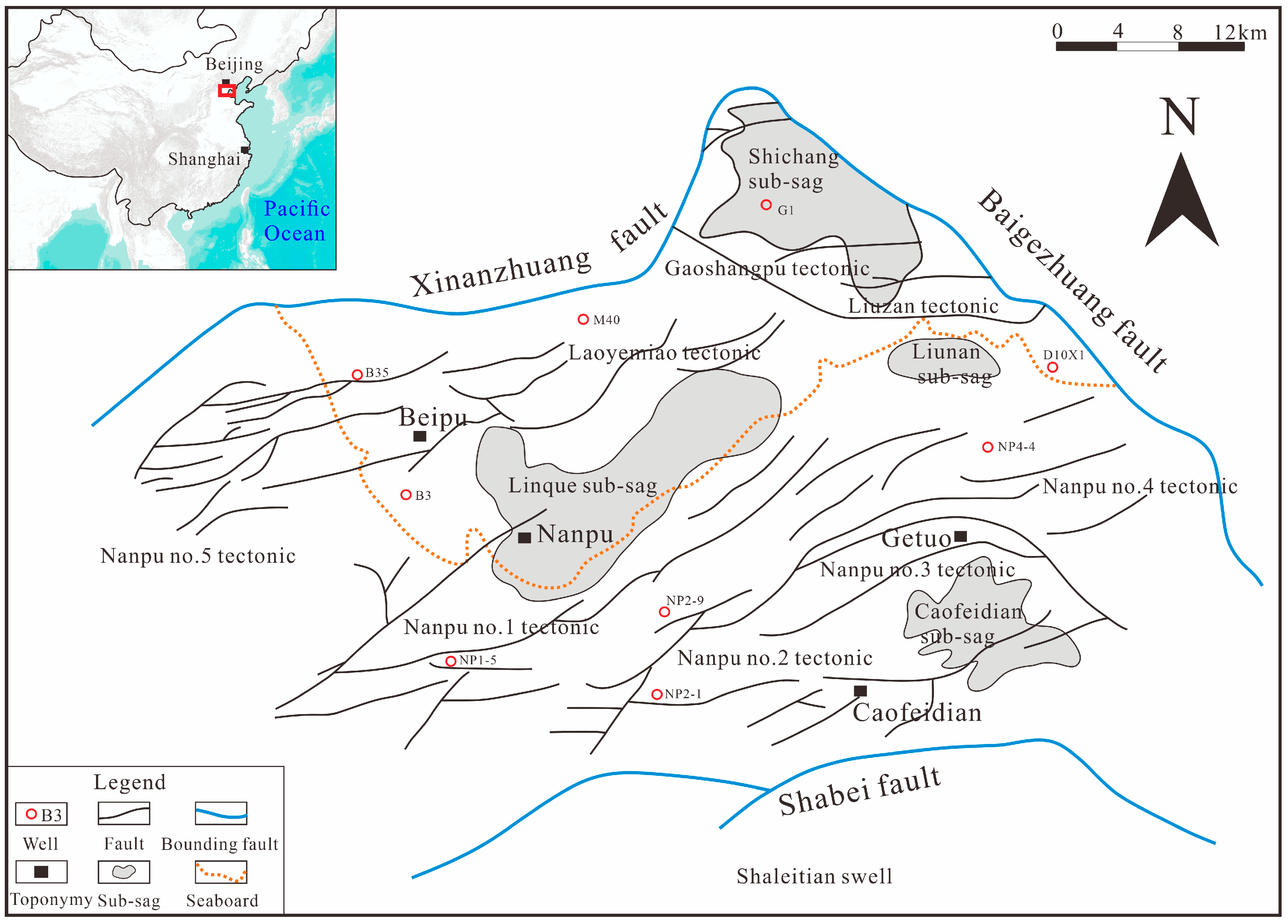
2. Regional Geological Background

Nanpu sag is located in the northern part of Huanghua sag (Figure 1), with an area of 1932 km2, spanning over sea and land, including 540 km2 of land part and 260 km2 of marine–continental transitional zone, which is a land-phase fracture basin developed on the base of North China plateau through the block fracture movement of the Middle and Cenozoic Era. The area is bounded by the Xinanzhuang deep fracture, Laowangzhuang bulge, and Xinanzhuang bulge to the north; the Baigezhuang deep fracture (adjacent to Baigezhuang bulge, Matouying bulge, and Shishuituo bulge) to the east; the Shaleitian bulge to the south; and the Beitang sag to the west. The Nanpu sag is characterized by the development of different levels and contemporaneous fractures, and the complex fracture system formed by the fractures and the fracture blocks they divide is the main feature of the Nanpu sag. Fractures mostly extend in the NNE and near-EW directions; based on scale and function, they are classified as first-order “concave-control” fractures, second-order “belt-control” fractures, and third- to fourth-order faults. The concave-controlled fractures are mainly homogenous boundary fractures, including the Baigezhuang fracture, the Xinanzhuang fracture, the Shabei fracture, and the Gaoliu fracture. The Nanpu sag has a maximum thickness of 8000 m of Paleocene sedimentary rocks and consists of strata of the Paleocene Shahejie Fm, Dongying Fm, and the Neocene Minghuazhen Fm and Guantao Fm. Among them, the stratum of Shahejie Fm is divided into the third-first member of the Shahejie Fm from bottom to top; Dongying Fm can also be divided into the third-first member of the Dongying Fm from bottom to top. Compared with other sags in the Bohai Bay Basin, the Nanpu sag has many similarities and obvious differences. The sedimentary stratum of the Dongying Fm is relatively thicker than that of other sags, but it lacks the sedimentary stratum of the fourth member of the Shahejie Fm.

3. Materials and Methods

3.1. Geological Fieldwork and Indoor Testing

In this study, we carried out field geological investigations and sampling of outcrop profiles in the Yanshan orogenic belt (Tangshan area) on the margin of the Bohai Bay basin. Borehole core samples were taken from key exploration and development wells like the G15 well in the Gaoshangpu oilfield and the L9 well in the Liuzan oilfield. All samples are fresh and unaffected by weathering. In order to reduce the oxidation of the samples and avoid contamination, the samples were packed in plastic bags. Through these efforts, we have gained a preliminary understanding of the parent rock type, weathering intensity, and paleohydrological characteristics of the source area and analyzed the correlation between the recharge of the source area and the scale of sand development. Through the observation of the cores, we identified sedimentary structures such as interlayers and metamorphic layers. These rocks were characterized by thin-section microanalysis, and petrological parameters such as quartz content and sortability were determined, which provided direct evidence for discerning the depositional environment of the Nanpu sag.

3.2. Stratigraphy and Sedimentary Phase Analysis

This part of the study utilized mainly logging, recording, and seismic data. In this study, seismic data covering the whole area of Nanpu sag and logging curves (GR, SP, and RT) and rock chip recordings from more than 56 exploratory wells were collected. The logging curve data are mainly used for lithology identification, sand thickness statistics, and sedimentary phase delineation. On this basis, the vertical sequence characteristics of sand bodies in each sedimentary phase were interpreted and evaluated in conjunction with rock chip logging data. Based on Vail’s classical stratigraphic theory, the secondary and tertiary stratigraphic sequences of the Paleocene are classified by combining with the tectonic activity characteristics of the Nanpu sag. The sedimentary filling style of each fracture period was clarified by the method of seismic profile top flattening and stratigraphic interface tracing. The spatial distribution characteristics of major fracture structures (like Xinanzhuang and Baigezhuang faults) and slope fault zones were identified using seismic data. The spatial structure of sand boundaries and sedimentary systems was analyzed and interpreted using a combination of logging and seismic methods.

3.3. Paleomorphic Restoration

This part of the study mainly uses the residual thickness method to recover the paleogeomorphic evolution process of different rift trap periods. Finally, the controlling effect of the ditch slope fracture zone on the distribution of sand bodies in the Nanpu sag is analyzed in relation to the type and scale of sand development.

4. Results and Interpretations

4.1. Characterization of the Valley at Basin Margin

In marine–continental rift basins, basin margin valleys transport water systems and clastic materials into the lake basin [52]. These valleys are not only primary zones for clastic sedimentary development but also critical paleomorphological indicators for sand exploration and prediction [53,54]. Basin-marginal valleys can be categorized into three types according to their genesis: faulted troughs, fault accommodation zones, and incised valleys.

4.1.1. Faulted Trough

Faulted troughs are the most common type of basin margin valleys [55]. They form either as intersecting structures between two sag-controlling faults with differing strike directions or as grabens created by faults oblique to the sag-controlling faults [56]. These troughs serve as both the entry points for the sag basin’s water system into the lake and the primary zones for developing various sandstone-conglomerate fans.

4.1.2. Fault Accommodation Zone

Large-scale plate-control faults initially originate from small faults that evolve and interact to form a unified large fault. Their junctions, often characterized by minimal differences, coincide with the development of early conversion zones and accommodation zones, which act as entry points for the material source’s water system. The Xinanzhuang fault, a NEE-trending sinusoidal curvilinear boundary fault in the Nanpu sag, exhibits distinct segmental activity, with its western and central segments aligning near EW and its eastern segment near NS. This fault controls the formation, orientation, and sand distribution of the Nanpu No. 5, Laoyemiao, and Gaoshangpu tectonic zones. The Paleocene system is the main activity period of the Xinanzhuang fault. The Laoyemiao tectonic zone develops at the junction of the central and eastern segments of the Xinanzhuang fault, formed by the linkage of small faults. In this zone, fault activity and subsidence are weak, while stronger activity and faster subsidence occur on both sides. This contrasting dynamics creates accommodation sags at the junction, forming a sediment pathway that facilitates sand migration along the fault-regulated zone into the basin.

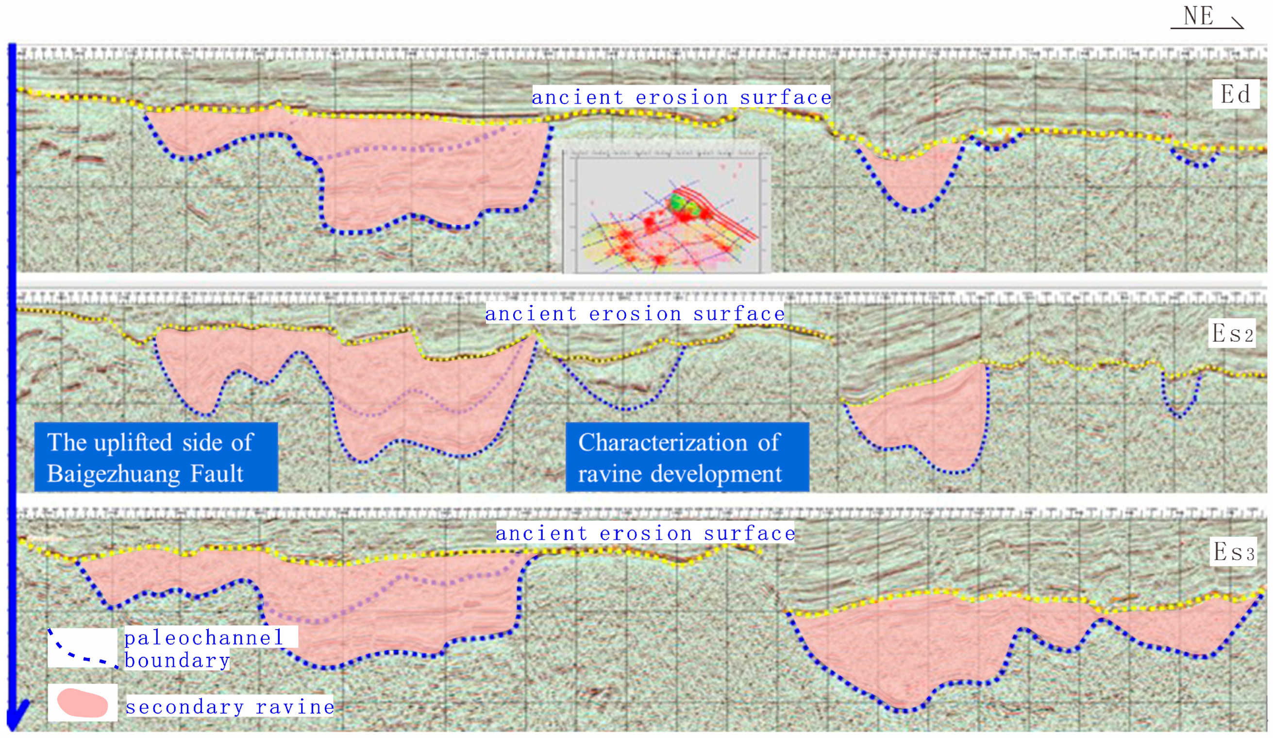
4.1.3. Incised Valley

Incised valleys, typically located on lake basin margins or above lake shorelines, form due to rapid declines in datum level, triggering riverbed undercutting along or independently of faulted troughs or regulating zones [57]. These valleys act as conduits for transporting large volumes of detritus into the basins. Combined with deep-source seismic profiles in the study area [58], four gullies can be identified on the Baigezhuang Fault, and two secondary gullies can be identified in the large gully in the northwest section of the Baigezhuang fault (Figure 2). From the distribution of incised valleys on the stripped surface of the present fault, the Paleocene sand in the Nanpu sag is strongly inherited vertically and controlled by the development of incised valleys horizontally.

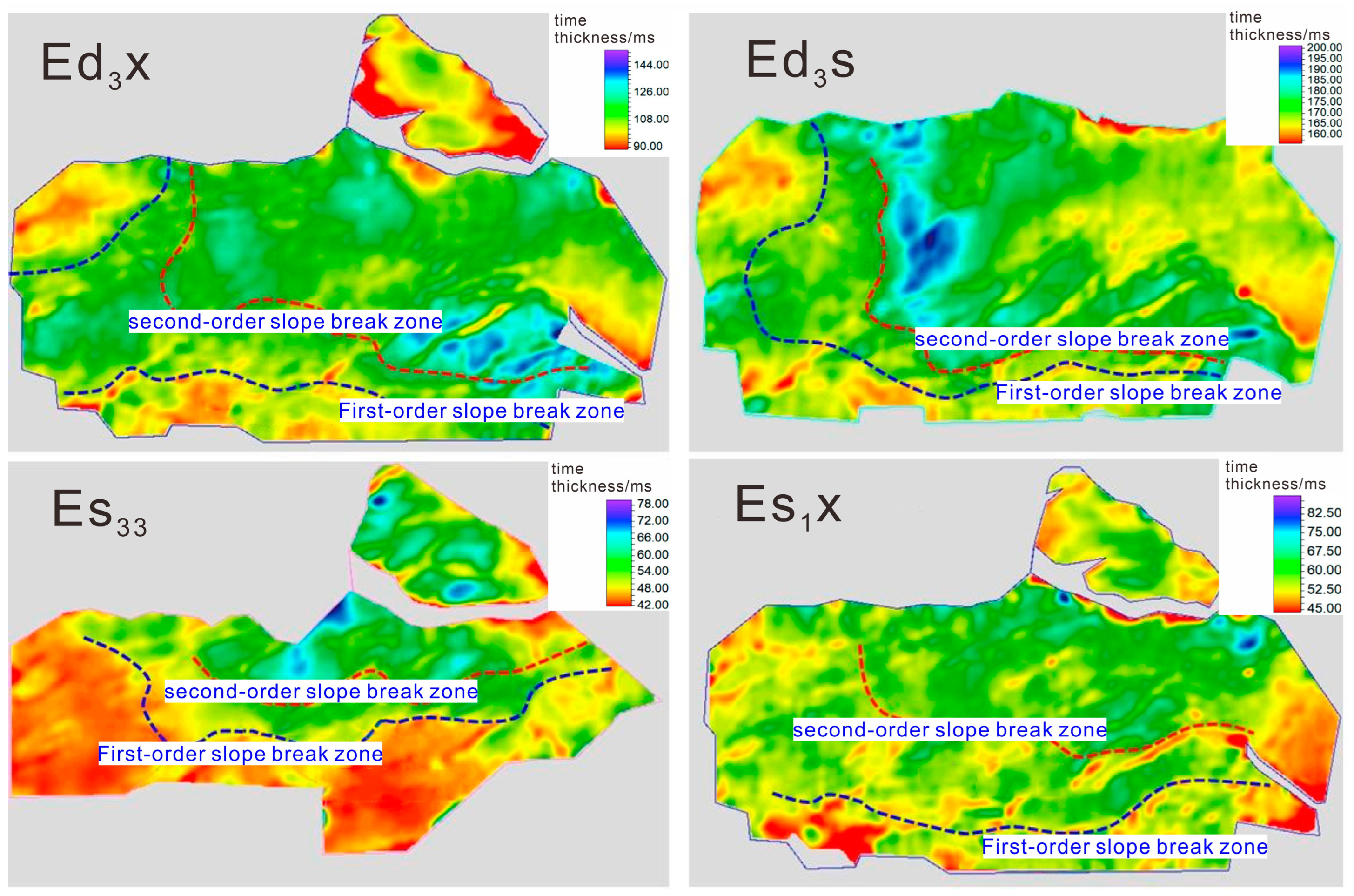
4.2. Characterization of the Slope Break Zone

The slope break zone, a geomorphologic concept describing abrupt topographic slope changes, develops in both sedimentary basins and denudation zones [59,60]. The types of slope break zone in the marine–continental rift basin are mainly syn-sedimentary fracture tectonic slope break zone and paleotopographic flexural depositional slope break zone, etc. [61,62]. The main characteristics of the slope break zone are the rapid change of stratigraphic thickness. The main feature of the slope break zone is the dramatic thickening of the stratigraphic sequences, which is clearly reflected in the seismic, geologic profile and stratigraphic thickness maps [63,64]. In the later period, the original appearance of the slope break zone has been changed through the effects of burial compaction and tectonic activities [65].
Under the influence of tectonic activities, the Nanpu sag developed several slope break zones related to sedimentation during the Paleoproterozoic depositional period, which have responses in the time thickness of the third-order stratigraphic sequence (Figure 3). Analysis of the third-order stratigraphic time thickness map in Nanpu sag shows that there are two obvious slope break zones—the first-order and second-order slope break zones—exhibiting markedly different developmental characteristics across secondary stratigraphic periods.
The analysis of the top flattening seismic sections shows that there are obvious structural characteristics of a secondary slope break zone in the Nanpu sag during the development of Es3 secondary sequences. In the western section, both the first-order and second-order slope break zones are paleotopographic flexural depositional slope breaks. The first-order slope break zone comprises a narrow slope zone and a wider platform zone above it. The second-order slope break zone similarly includes a slope zone and a platform zone, but both are wider than those in the first-order zone, with the platform zone remaining broader than the slope zone.
The analysis of the Es2-Es1 secondary layer sequence top flattening seismic sections shows that there are also obvious secondary slope break zone structural features in the slow-slope zone during this period. The western and eastern sections of the grade I and grade II slope break zone are both paleotopographic flexural depositional slope breaks, and above the grade I slope break zone is the platform zone above the slope break zone. The grade I slope break zone consists of the slope break zone and the platform zone, with narrower widths and larger widths in the platform zone, which is significantly wider compared with the Es3 secondary sequences. The width of the platform zone is larger than that of the Es3 secondary sequence, and the width of the grade I slope-folding zone has increased significantly.
After the sedimentary filling effect of the Shahejie Fm, the topographic slope of the Dongying Fm was relatively gentle during the depositional period, and the secondary slope break zones are still developed. The grade I and grade II slope break zones in the western and eastern sections are paleotopographic flexural depositional slope breaks, with a platform zone overlying the grade I slope break zone. The grade I slope break zone comprises a slope zone and a platform zone (significantly narrower than the Shahejie Fm secondary sequence). The grade II slope break zone exhibits a narrower slope zone than grade I, while its platform zone remains comparatively wider.

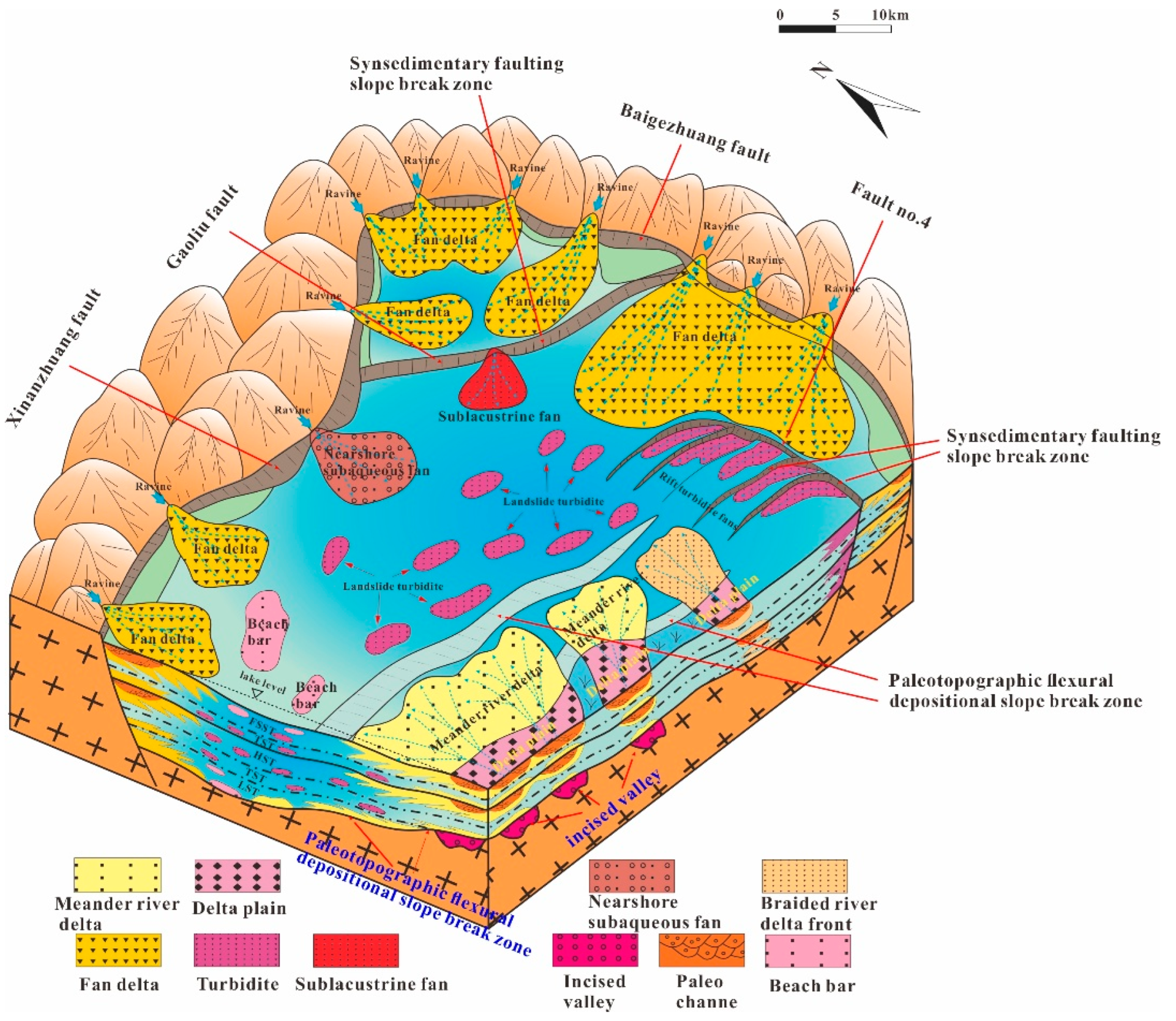
4.3. Sand Distribution Controlled by Valley–Slope Break Zone

Faulted troughs, slope break zones, and incised valleys developed at the margin of the marine–continental rift basin control the injection positions of the basin water system. These structural features promote the continuous development of diverse deltaic sedimentary bodies, while the differentiation and aggregation of sand bodies in the lake basin are influenced by syn-sedimentary slope break zones. The “sand controlled by faulted slope” mechanism (proposed by earlier studies) is evident in both the gentle and steep slope zones of the Nanpu sag and faulted trough. This mechanism of sand control is obvious in both the gentle and steep slopes of the Nanpu sag. However, the configuration of the valley–slope break zone and its control effect on sand development varied across different rifting periods due to tectonic activity, material source supply, and climate changes in the lake basin.

4.3.1. Rifting Period I (Es3 Period)

During the Es3 depositional period, the Nanpu sag went through the whole process of initial rifting, lake expansion, and then basin shrinkage and uplift by denudation. During this period, the southern source system remained undifferentiated, dominated by incised valleys, with slope break zones primarily consisting of paleotopographic flexure sedimentary types and partial synsedimentary fracture tectonic types. These conditions facilitated large-scale braided river delta development in gentle-slope valley–slope break configurations. In contrast, the northern and eastern source systems were oriented perpendicular to boundary faults, supplying clastic material to the basin, where diverse valley types (faulted troughs, fault break zones, and down-cut valleys) were observed. The slope breaks are predominantly syn-sedimentary rupture tectonic slope break zones, with sands migrating along the footwalls of the Xinanzhuang, Gaoliu, and Baigehuang faults into the lake basin in steep-slope areas where valley–slope break configurations are well-developed, forming fan-delta sedimentary folding. This deposition persisted until the late Es3 period, when regional uplift caused erosion of the gently sloping beach and nearshore zones. In deep concave zones near the lake basin center, braided river deltas were extensively developed under the influence of syn-sedimentary slope break zones. Near the deep concave zone of the lake basin, sedimentary slope break zones promote the formation of gravitational flow sand bodies, including landslide turbidite fans and slope break turbidite fans. These sand bodies are sporadically distributed at the frontal edges of fan deltas and braided river deltas.

4.3.2. Rifting Period II (Es2-Es1 Period)

During the Es2-Es1 depositional period, the early climate was more arid, the lake basin was in a shallow water environment, and the range of deep lakes was limited. Faulted troughs, fracture adjustment zones, and incised valleys can be seen in abundance in the steep-slope zone, and the slope break zones are dominated by syn-sedimentary tectonic fractures. In steep-slope areas with well-configured valley–slope break zones, sands entering the lake basin along valleys are dispersed along the footwalls of the Xinanzhuang, Gaoliu, and Baigezhuang faults, where fan delta sedimentary dolomites are progressively developed. The fan sizes, however, diminish due to reduced material source supply. Reduced material source supply caused significant recession of fan scales, while tectonic uplift led to denudation in the beach area. In the southern source system, diminished material supply drastically contracted deltaic deposition ranges, with valleys dominated by incised valleys and slope breaks primarily characterized by paleotopographic flexure-deposited zones. Small-scale braided river deltaic deposits developed in gentle-slope areas with favorable valley–slope break zone configurations. During the Es1 period, the Gaoliu fault became active, dividing the Nanpu sag into northern and southern parts. The downthrown side of the Gaoliu fault developed a small-scale lake-bottom fan sedimentary, while the No. 4 fault’s downthrown side hosted faulted trough turbidite fan deposition influenced by the fault strike. In the northern Nanpu sag, the Xinanzhuang fault’s downthrown side exhibited smaller-scale nearshore submerged fan deposition within the beach and dam sand deposition range, whereas the gently sloping braided river delta area transitioned to a faulted trough delta under southern source system control. Near the lake basin’s deep concave zone, sporadic sliding collapse turbidite fan sedimentary bodies formed at the frontal edges of fan deltas, braided river deltas, nearshore underwater fans, and faulted trough turbidite fans, influenced by the same sedimentary slope break zone (Figure 4).

4.3.3. Rifting Period III (Ed Period)

During the Ed depositional period, the basin underwent reactivation rift-sink processes; activity of the Gaoliu fault caused stratigraphic warping and tilting, leading to the uplifted side of the fault ceasing deposition during the middle-late Dongying Fm and becoming a source area. Subsequently, the northern tectonically controlled source system gradually declined, while the western side of the Xinanzhuang fault weakened, and the Nanpu No. 5 tectonic zone transitioned from fan-delta to braided-river delta deposition. The northeastern and eastern source systems progressively blended under these structural and depositional adjustments. In the downthrown sides of Laoyemiao, Gaoliu fault, Liunan, and Bainan areas, fan delta deposition developed continuously due to favorable configurations of iso-sedimentary fracture tectonic slope break zones associated with various gullies. The southern source system, influenced by increased material supply, formed extensive braided river delta deposition in the beach and sea areas, shaped by incised valley–paleotopographic flexural depositional slope break zones. Near the deep concave zone of the lake basin, sporadic sliding collapse turbidite fan deposits formed at the front edges of fan deltas and river deltas under the control of the same depositional slope break zone.

5. Discussion

5.1. Sand Architecture and Hydrocarbon Enrichment

Based on the analysis above, the spatial distribution of sand bodies is governed by the interplay between valleys and syndepositional slope breaks, which critically influences hydrocarbon accumulation in the Nanpu sag. Braided channel deltas and fan delta systems developed near slope break zones (like Gaoshangpu and Liuzan oilfields) exhibit high sand content and lateral continuity, forming effective reservoirs. These sand bodies are typically superimposed on Paleogene source rocks of the Shahejie Fm, creating favorable conditions for hydrocarbon migration and entrapment. For instance, fan delta deposits along major boundary faults act as primary reservoirs, with thick sandstone layers directly overlying organic-rich mudstones. In contrast, gravity flow deposits in deeper lacustrine settings, though discontinuous, are often enveloped by sealing mudstones, forming isolated lithologic traps. The discovery of oil-bearing gravity flow sand bodies in the Liuzan area highlights the exploration potential of such stratigraphic traps, particularly where sand bodies are juxtaposed with mature source rocks.

5.2. Fan Deltas and Hydrocarbon Enrichment

Fan delta systems in the steep slope zones of the Nanpu sag display pronounced spatiotemporal variability due to tectonic and climatic fluctuations during different rift stages. During the initial rifting phase (Es3), intense tectonic subsidence and abundant sediment supply from northern provenance areas promoted the development of extensive fan delta lobes characterized by coarse-grained sediments. These lobes extended basinward along fault-controlled pathways, forming amalgamated sand-rich sequences. In later stages (Ed), reduced tectonic activity and sediment input led to smaller, more localized fan delta deposits with higher proportions of fine-grained material. Core observations and seismic facies analysis reveal upward-fining sequences in these systems, transitioning from conglomerates to laminated sandstones. Such heterogeneity underscores the need to integrate tectonic evolution and provenance dynamics when predicting reservoir quality and distribution.

5.3. Gravity Flow Deposits and Hydrocarbon Enrichment

Gravity flow deposits, though volumetrically subordinate, play a significant role in deep-water hydrocarbon exploration. These deposits originate from two primary mechanisms:
  • Slope failure triggered by syndepositional tectonic oversteepening;
  • Hyperpycnal flows associated with seasonal flooding events [67].
In the Nanpu sag, seismic profiles and core data indicate that gravity flow deposits are predominantly concentrated near syndepositional slope breaks or at the distal ends of fan delta systems [68]. For example, slide–slump complexes near the Gaoliu fault exhibit chaotic seismic reflections and contain poorly sorted sediments, while turbidite channels display distinct graded bedding. These deposits, though limited in lateral extent, often occur within or adjacent to source rock intervals, enabling efficient hydrocarbon charging. Their stratigraphic isolation within mudstone-dominated successions enhances trap integrity, making them promising targets for lithologic exploration.

6. Conclusions

  • The correspondence between the development of the Paleocene sand and paleogeomorphology in the Nanpu sag shows that the faulted trough can be categorized into three basic types: faulted trough, faulted regulating zone, and incised valley, according to the cause of the water carrying sediments into the lake. Marine–continental rift basins predominantly develop syn-sedimentary fracture tectonic and paleo-topographic flexural depositional slope break zones, with sand thickness markedly increasing beneath these zones.
  • In marine–continental rift basins, tectonic activity, material source supply, and climatic fluctuations during distinct rifting periods drive variability in the valley–slope break zone’s control over sand development. In areas with favorable valley–slope break zone configurations, the foot and adjacent regions of these zones often serve as prime sites for diverse sand development, extending basinward under hydrodynamic influences.
  • The study on sand distribution controlled by valley–slope break zones in the Nanpu sag demonstrates that braided river deltas and fan deltas near slope breaks (like Gaoshangpu and Liuzan oilfields) develop large-scale, high-continuity reservoirs, while gravity flow deposits in deep lacustrine environments, though spatially limited, form effective lithologic traps due to stratigraphic isolation. Temporal variations in tectonic activity and sediment supply—coarse-grained fan deltas dominating during the early rifting phase (Es3) and transitioning to finer-grained, smaller-scale deposits in later stages (Ed)—further define sand heterogeneity. This research elucidates the geomorphic–tectonic coupling mechanisms governing sand architecture, advances valley–slope break zone theory, and provides a practical framework for predicting lithologic traps, particularly in slope break–valley coupling regions and deep-water gravity flow systems. These findings offer both theoretical and operational insights for hydrocarbon exploration in analogous continental rift basins.

Author Contributions

Conceptualization, methodology, investigation, data curation, writing original draft preparation, and visualization, B.G.; writing—review and editing, S.W.; supervision, project administration, and funding acquisition, P.S. All authors have read and agreed to the published version of the manuscript.

Funding

This research was funded by the National Science and Technology Major Project “The Law of Oil and Gas Enrichment and the Field of Increasing Storage in Nanpu Sag” (2022ZX05006-006) and China National Petroleum Corporation Science and Technology Major Project “The Fourth Oil and Gas Resource Evaluation in Nanpu Sag and peripheral Areas” (2022E-050211).

Data Availability Statement

Dataset is available on request from the authors.

Conflicts of Interest

The authors declare no conflicts of interest.

Abbreviations

The following abbreviations are used in this manuscript:
FmFormation

References

  1. Lin, C.S.; Pan, Y.L.; Xiao, J.X. Structural slope-break zone: Key concept for stratigraphic sequence analysis and petroleum forecasting in fault subsidence basins. Earth Sci. 2000, 25, 260–266. [Google Scholar]
  2. Li, S.T.; Pan, Y.L.; Lu, Y.C. Key technology of prospecting and exploration of subtle traps in lacustrine fault basins: Sequence stratigraphic researches on the basis of high resolution seismic survey. Earth Sci. 2002, 27, 592–599. [Google Scholar]
  3. Feng, Y.L.; Qiu, Y.G. Application of high-resolution sequence stratigraphy to exploration of Lower Tertiary subtle reservoirs in Jiyang Subbasin. Acta Pet. Sin. 2003, 24, 49–52. [Google Scholar]
  4. Liu, H.; Wang, Y.M.; Wang, Y. Characteristics of slope breaks and their control on atectonic traps in downwarped lake basin. Acta Pet. Sin. 2004, 25, 30–35. [Google Scholar]
  5. Li, P.L.; Pang, X.Q. Formation of Hidden Hydrocarbon Reservoirs in Sag Basins; Petroleum Industry Press: Beijing, China, 2004; pp. 1–19. [Google Scholar]
  6. Chen, Z.; Zhang, C.M.; Hou, G.W.; Feng, W.J. Fault distribution patterns and their control on sand bodies in Pinghu Formation of Xihu Sag in East China Sea Shelf Basin. Oil Gas Geol. 2020, 41, 824–837. [Google Scholar]
  7. Huang, J.B.; Wang, G.W.; Wang, Q.M.; Yu, X.T.; Wang, X.Y. The source to sink systems and their exploration significance for the 1st and 2nd members of the Palaeogene Shahejie Formation in the middle part of the Bonan low uplift. Sediment. Geol. Tethyan Geol. 2019, 39, 40–47. [Google Scholar]
  8. Li, K.; Zhou, X.H.; Ding, F.; Yuan, J.; Shen, S.; Lv, P. “Multi–factor control of sandboies distribution” in the Pinghu Formation, Pingbei region of Baochu slop, the Xihu Sag. Mar. Geol. Quat. Geol. 2019, 39, 115–123. [Google Scholar]
  9. Xing, F.C.; Lu, Y.C.; Liu, C.H.; Xiang, K. Structural-paleogeomorphologic features of Chepaizi Area and mechanism of their control on sandbodies. Oil Gas Geol. 2008, 29, 78–83. [Google Scholar]
  10. Yang, X.B.; Chen, Z.Y.; Chen, Z.Y.; Man, Y. Sand distribution mechanism of Liushagang Formation in eastern Wushi Area. Fault-Block Oil Gas Field 2017, 24, 342–345. [Google Scholar]
  11. Xia, Q.L.; Xu, C.G. New geological understandings and major hydrocarbon discoveries in the complex fault zone of Bohai Sea. Acta Pet. Sin. 2016, 37, 22. [Google Scholar]
  12. Xu, C.Q.; Li, H.; Wang, G.Q.; Li, L.; Sun, X.J. Application of the Source-Sink Time-Space Coupling Sandbody-Controlling Principle in the Study of Sedimentary System: A Case Study of the Ed_3 Formation in Qinhuangdao A Area, Bohai. J. Xi’an Shiyou Univ. Nat. Sci. Ed. 2017, 38, 580–588. [Google Scholar]
  13. Zhou, Y.H.; Yang, S.C.; Feng, J.W.; Lan, Z.Q.; Zhang, B.M. Characteristics of fault activities and the controlling on sand bodies during Es_1 period in Nanpu No.3 unit. J. Northeast Pet. Univ. 2016, 40, 27–35. [Google Scholar]
  14. Wang, W.; Fan, T.E.; Hu, G.Y.; Niu, T.; Wang, G.D. Characteristics of Fault Accommodation Structure Slope Break Zone and the Sand Control Pattern in a Oilfield. J. Southwest Pet. Univ. 2015, 37, 39–46. [Google Scholar]
  15. Xu, C. Controlling sand principle of source-sink coupling in time and space in continental rift basins: Basic idea, conceptual systems and controlling sand models. China Offshore Oil Gas 2013, 25, 1–11. [Google Scholar]
  16. Xu, C.G.; Gao, Y.D.; Liu, J.; Peng, G.R.; Liu, P.; Xiong, W.L.; Song, P.L. Discovery and inspiration of large- and medium-sized glutenite-rich oil and gas fields in the eastern South China Sea: An example from Paleogene Enping Formation in Huizhou 26 subsag, Pearl River Mouth Basin. Pet. Explor. Dev. 2024, 51, 15–30. [Google Scholar] [CrossRef]
  17. Li, A.Q.; Yang, X.B.; Fan, C.W.; Wang, Z.Z.; Li, M. Sandy Debris Flow Sedimentary Characteristics and Patterns in the Meishan Formation of Northern Lingshui Sag, Qiongdongnan Basin. J. Phys. Conf. Ser. 2020, 1549, 022009. [Google Scholar] [CrossRef]
  18. Zhang, X.T.; Zhou, X.H.; Li, J.P.; Niu, C.M. Unconfined Flow Deposits in Front Sandbodies of Shallow Water Deltaic Distributary Systems. Acta Sedimentol. Sin. 2014, 32, 260–269. [Google Scholar]
  19. Feng, Y.L. Control of valley and tectonic slope-break zone on sand bodies in rift-subsidence basin. Acta Pet. Sin. 2006, 27, 13–16. [Google Scholar]
  20. Xian, B.Z.; Wang, Y.S.; Zhou, T.Q. Distribution and controlling factors of glutinite bodies in the actic region of a rift basin: An example from Chezhen sag Bohai bay basin. Pet. Explor. Dev. 2007, 34, 429–436. [Google Scholar]
  21. Deng, H.W.; Guo, J.Y.; Wang, R.J. Tectono-sequence stratigraphic analysis in continental faulted basins. Earth Sci. Front. 2008, 15, 1–7. [Google Scholar] [CrossRef]
  22. He, Z.S.; Liu, H.; Lin, H.M.; Qiu, X.W.; Wang, X.D.; Ju, Y.T.; Jue, X.M. Controlling effect of slope-break zone and paleovalley on sedimentation in rifted lake basins: A case study of the Paleogene Wenchang Formation in Haifeng 33 Subsag, Pearl River Mouth Basin. Oil Gas Geol. 2023, 44, 441–451. [Google Scholar]
  23. Wu, H.B.; Li, J.; Liu, H. Types of Structural Slope-break Zone and Its Controls on Sand Bodies and Hydrocarbon of Huhehu Depression in Hailar Basin. Acta Sedimentol. Sin. 2013, 31, 358–365. [Google Scholar]
  24. Liu, X.; Li, J.; Liu, Y.; Chen, Q.; Bai, Y.; Li, F.; Jin, L.; Zhang, B. Characterization of Architecture Bounding Surfaces in Fluvial Tight Sandstone Reservoirs and Their Influence on Remaining Gas: A Case Study from the Suzhong Block, Sulige Gas Field. Energies 2024, 17, 4262. [Google Scholar] [CrossRef]
  25. Pang, X.J.; Wang, G.M.; Wang, Q.B.; Zhang, X.F. The reservoir characteristics and their controlling factors of the sublacustrine fan in the Paleogene Dongying Formation, Bohai Sea, China. J. Palaeogeogr. 2024, 13, 127–148. [Google Scholar] [CrossRef]
  26. Zhang, H.Y.; Xu, Y.X.; Li, H.; Cao, Z.; Wang, K.; Wang, Y.L. Sandy accumulation law and reservoir development characteristics in Nanpu Structure 1 and Structure 2. Oil Geophys. Prospect. 2018, 53, 329–334+20. [Google Scholar]
  27. Lyu, Q.Q.; Fu, J.H.; Luo, S.S.; Li, S.X.; Zhou, X.P. Sedimentary characteristics and model of gravity flow channel-lobe complex in a depression lake basin: A case study of Chang 7 Member of Triassic Yanchang Formation in southwestern Ordos Basin, NW China. Pet. Explor. Dev. 2022, 49, 1323–1338. [Google Scholar] [CrossRef]
  28. Zhang, Z.P.; Qi, Y.K.; Wang, H.Z.; Jin, Y.Y.; Huang, S.B.; Chang, W.X. Trap development patterns and exploration potential of Badaowan Formation in Baolangsumu structural belt-Sishilicheng slope belt in Yanqi Basin. Pet. Geol. Oilfield Dev. Daqing 2023, 42, 9. [Google Scholar]
  29. Zhang, Y.Z.; Tan, J.; Wang, L.; Chang, W.Q.; Xu, J.Q. Characteristics and controlling factors of lacustrine source rocks in the Lower Cretaceous, Suhongtu Depression, Yin-E Basin, Northern China. Mar. Pet. Geol. 2021, 104, 943. [Google Scholar]
  30. Proverbs, I.P.; Bann, K.L.; Taylor, B. Depositional, stratigraphic and structural controls on the geometry of Montney Formation reservoirs: Lower Triassic, northeast British Columbia, northwest Alberta. Bull. Can. Energy Geosci. 2024, 71, 38. [Google Scholar] [CrossRef]
  31. Xiang, J.B.; Zhang, X.; Liu, J.; Meng, Q.; Zhang, Y.; Li, X. Characterization and Modernization of the Depositional System in Modern Ebinur Lake Basin, Northwest China. Appl. Sci. 2024, 14, 4425. [Google Scholar] [CrossRef]
  32. Gao, M.; Yu, X.H.; Li, S.L.; Zhang, W.M.; Hu, S.H.; Zhang, M.L. Control of slope-pattern on the deposition of fan-delta systems: A case study of the Upper Karamay Formation, Junggar Basin. Front. Earth Sci. 2024, 18, 384–399. [Google Scholar] [CrossRef]
  33. Wei, G.Q.; Yang, W.; Xie, W.R.; Xie, Z.Y.; Zeng, F.Y.; Mo, W.L.; Shen, J.H.; Jin, H. Formation conditions, accumulation models and exploration direction of large-scale gas fields in Sinian-Cambrian, Sichuan Basin, China. Nat. Gas Geosci. 2016, 1, 9–19. [Google Scholar] [CrossRef]
  34. Guo, S.; Tan, L.J.; Lin, C.Y.; Li, H.N.; Lu, X.X.; Wang, H.T. Hydrocarbon accumulation characteristics of beach-bar sandstones in the southern slope of the Dongying Sag, Jiyang Depression, Bohai Bay Basin, China. Pet. Sci. 2014, 11, 220–233. [Google Scholar] [CrossRef]
  35. Fei, L.Y.; Wang, S.L.; Wu, T.; Wang, F.; Yu, C.H.; Li, Y.G.; Feng, C. Control of slope break zone on sandy debris flow deposition: A case study of Jurassic Sangonghe Formation in west sag of Well Pen-1 and its periphery in Junggar Basin. Pet. Geol. Recovery Effic. 2020, 27, 26–34. [Google Scholar]
  36. Zhang, J.J.; Wu, S.H.; Hu, G.Y.; Yue, D.L.; Chen, C.; Chen, M.; Yu, J.T.; Xiong, Q.C.; Wang, L.Q. Sedimentarye-tectonic interaction on the growth sequence architecture within the intraslope basins of deep-water Niger Delta Basin. J. Palaeogeogr. 2023, 12, 107–128. [Google Scholar] [CrossRef]
  37. Meng, Q.A.; Wu, H.B.; Li, J.H.; Liu, H.; Li, Y.; Zou, Y. Type classification of the slope area in the continental faulted lake basin and the hydrocarbon enrichment characteristics: Taking Wuerxun-Beier Sag in Hailar Basin as an example. Pet. Geol. Oilfield Dev. Daqing 2019, 38, 59–68. [Google Scholar]
  38. Gao, D.; Yang, S.C.; Zhao, Y.F. Cretaceous paleogeomorphology and its control on the sedimentation in Chepaizi area of Junggar Basin. Pet. Geol. Oilfield Dev. Daqing 2019, 38, 32–39. [Google Scholar]
  39. Yu, H.Y.; Jiang, T.; Pan, T.; Ou, Y.P. Control of Slope Breaks of Karagansky Formation on Sand Bodies in Baojingen Graben, Kazakhstan. Offshore Oil 2019, 39, 1–5. [Google Scholar]
  40. Zhang, X.J. Analysis of sand-controlling mechanism in valley-slope break system under low source supply mode: A case study of the Hutubi Formation of Cretaceous in the eastern wing of the Chepaizi Uplift. J. Northeast Pet. Univ. 2019, 43, 99–108. [Google Scholar]
  41. Jamil, M.; Siddiqui, N.A.; Raham, A.H.B.A.; Ibrahim, N.A.; Ismail, M.S.B.; Ahmed, N.; Usman, M.; Gul, Z.; Imran, Q.S. Facies Heterogeneity and Lobe Facies Multiscale Analysis of Deep-Marine Sand-Shale Complexity in the West Crocker Formation of Sabah Basin, NW Borneo. Appl. Sci. 2021, 11, 5513. [Google Scholar] [CrossRef]
  42. Jiang, H.; Wang, H.; Lin, Z.L. Periodic rifting activity and its controlling on sedimentary filling of Paleogene period in Nanpu sag. Acta Sedimentol. Sin. 2009, 27, 976–982. [Google Scholar]
  43. Wang, H.; Jiang, H.; Lin, Z.L. Relations between synsedimentary tectonic activity and sedimentary framework of dongying formation in Nanpu sag. J. Earth Sci. Environ. 2011, 33, 70–77. [Google Scholar]
  44. Wan, J.F.; Xian, B.Z.; Li, Z.P. Different levels of rift activity and its impact on deposition in offshore area, Nanpu sag. Acta Sedimentol. Sin. 2013, 31, 1059–1069. [Google Scholar]
  45. Wang, P.J.; Chen, C.Y.; Zhang, Y.; Gao, Y.F.; Qu, X.J.; Yi, J. Characteristics of volcanic reservoirs and distribution rules of effective reservoirs in the Changling fault depression, Songliao Basin. Nat. Gas Ind. B 2015, 2, 440–448. [Google Scholar] [CrossRef]
  46. Zhang, W.; Liu, X.J.; Liang, L.X.; Xiong, J.; Wu, J.J.; Li, B. Fracture characteristics of reservoirs with different lithologies in marine-continental transitional facies and its influence on fracturing. Pet. Geol. Recovery Effic. 2024, 31, 74–88. [Google Scholar]
  47. Jiang, S.H.; Zhang, W.; Li, S.Z.; Wang, G.; Cao, W.; Su, Y.H.; Lu, L.L.; Jiang, Y.; Zhao, F.Y. Cenozoic Oil-gas Distribution and Tectonic Evolution of the Basins in the Northwest Pacific Continent-ocean Connection Zone. Geotecton. Metallogenia 2019, 43, 839–857. [Google Scholar]
  48. Tan, J.Q.; Ma, X.Y.; Hua, S.H.; Ma, X.; Wang, B.H.; Zhang, B.M.; Tian, W.; Jiang, S.; Hu, R.N. Influence of Sedimentary Environments on Organic Matter Enrichment in Marine-Continental Transitional Shale: A Case Study of the Upper Permian Longtan Formation in the Central Hunan Depression, China. Energy Fuels 2024, 38, 16. [Google Scholar] [CrossRef]
  49. Hu, Z.Z.; Norbert, K.; Jin, Y.; Li, C.Z.; Gong, L.X.; Li, D.Y.; Wang, S.; Yin, X.D. Assessment of Shale Gas Potential of Marine-Continental Transitional Longtan Formation from Southwestern Guizhou Province, China. Energy Fuels 2024, 38, 387–401. [Google Scholar] [CrossRef]
  50. Cai, H.; Qin, L.Z.; Liu, Y.H. Differentiation and Coupling Model of Source-to-Sink Systems with Transitional Facies in Pingbei Slope of Xihu Sag. Earth Sci. 2019, 44, 880–897. [Google Scholar]
  51. Ma, L.C.; Wang, Y.S.; Jing, A.Y.; Yang, G.L.; Wu, Y.Y.; Zhao, M.H. Paleogene tectonic styles and their controls on hydrocarbon accumulation in the shallow sea of the Jiyang Depression. Pet. Geol. Recovery Effic. 2018, 25, 1–5. [Google Scholar]
  52. Wang, X.; Mao, X.; Li, H.; Li, K.; Bao, Z. The Distribution Characteristics and Favorable Exploration Zones of Karst Reservoirs in the Beijing-Tianjin-Hebei Plain. In Proceedings of the 45th Workshop on Geothermal Reservoir Engineering, Stanford, CA, USA, 7–9 February 2020. [Google Scholar]
  53. Chang, J.; Chen, S.Y.; Liu, K.Y.; Yan, J.H.; Wang, Q.; Pu, X.G.; Yang, H.Y. Sedimentary characteristics and evolution of shallow water delta systems of the Lower Permian Shanxi Formation in the Bohai Bay Basin region. Arab. J. Geosci. 2022, 15, 99. [Google Scholar] [CrossRef]
  54. Zhang, R.H.; Yu, C.F.; Yang, Z.; Xiong, R.; Zhi, F.Q. Reservoir characteristics and geological implications of marine sandstone on the periphery of Awati Sag, Tarim Basin, China: Case study of Upper Ordovician-Lower Silurian Kepingtage Formation. J. Nat. Gas Geosci. 2025, 10, 1–11. [Google Scholar] [CrossRef]
  55. Yao, X.; Feng, C.; Qu, H.; Chen, J.; Sun, M. Depositional pattern and source-to-sink process of submarine fans in Lingshui and Sanya formations, Baodao Sag, Qiongdongnan Basin, China. J. Nat. Gas Geosci. 2024, 9, 87–97. [Google Scholar] [CrossRef]
  56. Dai, J.F.; Li, H.Y.; Zhang, M.S.; Bu, S.F. Reservoir prediction of glutenite fan based on time-frequency analysis. In Proceedings of the 2017 SEG International Exposition and Annual Meeting, Houston, TX, USA, 24–29 September 2017. [Google Scholar]
  57. Liu, H.; Loon, V.; Xu, J.; Tian, L.X.; Du, X.F.; Zhang, X.T.; Chen, D.L. Relationships between tectonic activity and sedimentary source-to-sink system parameters in a lacustrine rift basin: A quantitative case study of the Huanghekou Depression (Bohai Bay Basin, E China). Basin Res. 2020, 32, 587–612. [Google Scholar] [CrossRef]
  58. Sun, X.H.; Liu, J.; Zhang, Y.; Chen, B.; Xu, G. Study on Buried Channel Systems in the Western South Yellow Sea. Adv. Mar. Sci. 2013, 31, 367–376. [Google Scholar]
  59. Dong, G.Y.; Qiu, X.M.; Liu, Y.R. Prediction of Concealed Oil and Gas Reservoir Sand Bodies in Complex Continental Depression Basins: A Case Study of the Gaoyou Depression in North Jiangsu; Petroleum Industry Press: Beijing, China, 2013. [Google Scholar]
  60. Li, Z.Z.; Yang, Z.J.; Ji, Y.L.; Li, Y.H.; Wang, S.W.; Kang, Y.; Zhang, Z.L. Paleogene clastic reservoir which mainly controlled by the syndepositional faults in Shanghe Oilfield. Offshore Oil 2010, 30, 34–41. [Google Scholar]
  61. You, D.H.; Qian, Y.X.; Li, Z.Q.; Cai, X.Y.; Li, H.L. Carbonate Dissolution of Lianglitage Formation in Southern Slope Break of Tazhong Area. Xinjiang Pet. Geol. 2010, 31, 382–385. [Google Scholar]
  62. Wang, Y.T.; Zhang, S.; Lin, C.M.; Yang, Z.S. Characteristics of the Slope Break Belt and Its Control on the Depositional Sequence: The Quantou Formation of the Gulong Sag, Songliao Basin. Geol. J. China Univ. 2018, 24, 425. [Google Scholar]
  63. Zhou, L.; Yuan, B.; Song, Y.; Wu, Y.; Kong, Y.H.; Zhou, J.L.; Ma, T. A seismic quantitative identification method of slope break belt. Pet. Explor. Dev. 2016, 43, 1025–1034. [Google Scholar] [CrossRef]
  64. Liu, J.; Li, M.; Yang, C.Q.; Zou, M.S.; Qi, Z.; Fang, X.Y. Control of tectonic slope-break zones in the first member of Liushagang Formation of Weixinan Sag on sequence and sedimentary systems. J. Xi’an Shiyou Univ. Nat. Sci. Ed. 2014, 29, 49–57+58–59. [Google Scholar]
  65. Zhou, J. Research on the Role of the Basin-marginal Sequence Architectural Model in Controlling the Development of Sand-bodies and Traps—A Case Study of the Jurassic System in Hashan Area. Sci. Technol. Eng. 2016, 16, 177–185. [Google Scholar]
  66. Huang, H.; Zhang, T.S.; Zhang, X.; Liu, Y.L.; Gao, L.B.; Zhang, J.X. The Sedimentary Record of Marine–Continental Transitional Shales in the Upper Triassic of Xujiahe Formation, Southeast Sichuan Basin, China. J. Mar. Sci. Eng. 2025, 13, 646. [Google Scholar] [CrossRef]
  67. Jamil, M.; Siddiqui, N.A.; Umar, M.; Usman, M.; Ahmed, N.; Raham, A.H.B.A.; Zaidi, F.K. Aseismic and seismic impact on development of soft-sediment deformation structures in deep-marine sand-shaly Crocker fan in Sabah, NW Borneo. J. King Saud Univ.-Sci. 2021, 33, 101522. [Google Scholar] [CrossRef]
  68. Jamil, M.; Siddiqui, N.A.; Usman, M.; Wahid, A.; Umar, M.; Ahmed, N.; Haq, I.U.; EI-Ghali, M.A.K.; Imran, Q.S.; Rahman, A.H.A. Facies analysis and distribution of Late Palaeogene deep-water massive sandstones in submarine-fan lobes, NW Borneo. Geol. J. 2022, 57, 4489–4507. [Google Scholar] [CrossRef]
Figure 1. Tectonic location map of the Nanpu sag. The upper left map shows the regional topography of China. The red square represents the location of the study area.
Jmse 13 01077 g001
Figure 2. Developmental characteristics of the uplifted side incised valley on the Baigezhuang fault.
Jmse 13 01077 g002
Figure 3. Distribution characteristics of time thickness and slope break zones of different third-order in the Nanpu sag.
Jmse 13 01077 g003
Figure 4. A sand-control model for the gully–slope break zone of Paleocene rift II in Nanpu sag, summarized from the conclusions of Huang et al. in 2025 [66].
Jmse 13 01077 g004
Disclaimer/Publisher’s Note: The statements, opinions and data contained in all publications are solely those of the individual author(s) and contributor(s) and not of MDPI and/or the editor(s). MDPI and/or the editor(s) disclaim responsibility for any injury to people or property resulting from any ideas, methods, instructions or products referred to in the content.

