

Unlocking Brazil’s Maritime Potential: Expanding Ports for Post-Panamax Operations

 ,
,  ,
,  and
and 
Abstract
1. Introduction
2. Brazilian Ports
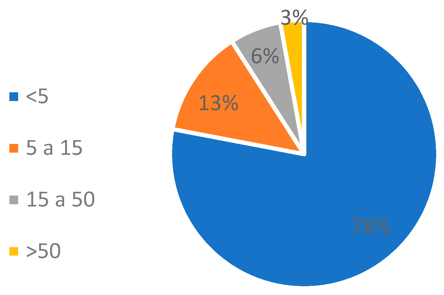
2.1. Tonnage Transported
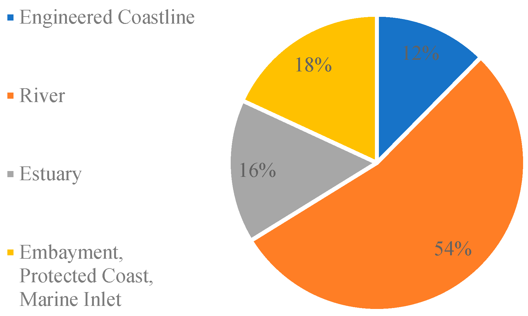
2.2. Geographical Characteristics
2.3. Regional Distribution
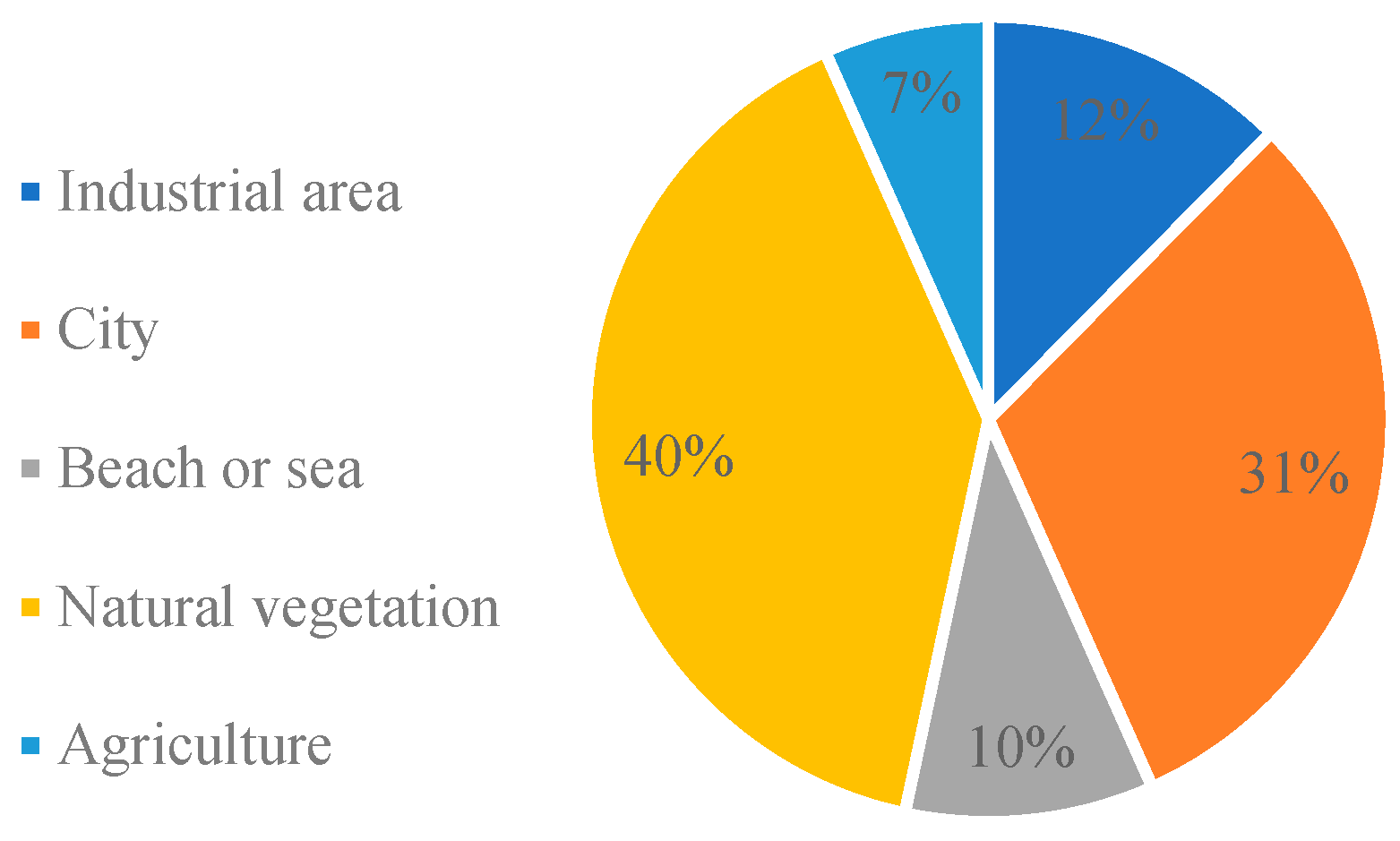
2.4. Land Use
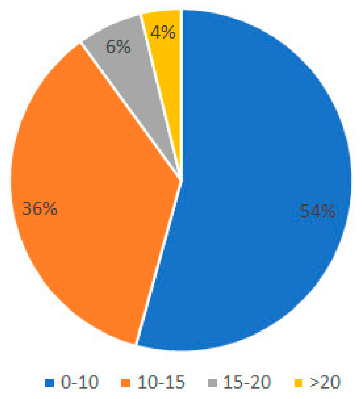
2.5. Water Depth
3. Methodology
3.1. Determination of Criteria
- Water depth: This criterion assesses the depth of the waterways within the port, particularly the channels and berths. It is essential for ports to have sufficient depth to accommodate the draft of post-Panamax vessels, which typically ranges around 15 m. Deeper water ensures safe navigation and prevents grounding or damage to the ships;
- Land capacity: This criterion evaluates the availability of land within the surrounding port area for the expansion or construction of new facilities necessary to accommodate post-Panamax ships. Ports may need ample space for additional container yards, storage areas, and other infrastructure to handle increased cargo volumes. A lack of space can hinder the port’s ability to expand and modernize its operations to meet the demands of larger vessels;
- Dredging: Dredging is the process of removing sediment and debris from waterways to maintain or increase their depth. Ports may need extensive dredging to deepen channels and berths to accommodate post-Panamax ships. The frequency and extent of dredging depend on factors such as tidal variations, sediment accumulation rates, and the draft of incoming vessels. Ports with significant dredging requirements must have the necessary resources and plans in place to carry out these maintenance activities effectively;
- Water accessibility: This criterion focuses on the navigational aspects of the port, including the width of channels, bridge clearance, and the curvature of waterways. Post-Panamax ships require wider and more navigable channels to maneuver safely within the port. Bridge clearance is crucial to ensure that vessels can pass under bridges without encountering height restrictions. Additionally, sharp curves or tight turns in the waterways can pose challenges for larger ships, requiring ports to assess and potentially modify their infrastructure to improve accessibility;
- Land and water connectivity: This criterion evaluates the presence and adequacy of transportation infrastructure connecting the port to inland areas with other modes of transportation. Ports need efficient road, rail, and possibly waterway connections to facilitate the movement of cargo to and from the port. Adequate infrastructure reduces congestion, improves cargo flow, and enhances the overall efficiency of the port. Ports lacking sufficient transportation infrastructure may face logistical challenges in handling the increased cargo volumes associated with post-Panamax ships.
3.2. Criteria’s Score
- A score of 10 represents the optimal scenario, where the port fully meets the criteria required for post-Panamax operations, such as sufficient water depth or robust connectivity;
- A score of 5 indicates an intermediate level, where the port meets some of the requirements but faces moderate limitations, requiring improvements or additional infrastructure to become fully suitable for larger vessels;
- A score of 0 signifies that the port does not meet the necessary conditions, presenting significant challenges or deficiencies that could impede its ability to handle post-Panamax ships.
3.3. Criteria Application
3.4. Examples of Criteria Application
3.4.1. Water Depth
3.4.2. Land Capacity
3.4.3. Dredging
3.4.4. Water Accessibility
3.4.5. Land and Water Connectivity
3.5. Ports’ Selection Process
4. Results
4.1. Analysis of Criteria Application
4.1.1. Water Depth
4.1.2. Land Capacity
4.1.3. Dredging
4.1.4. Water Accessibility
4.1.5. Land and Water Connectivity
4.2. Results of the Criteria Application
5. Conclusions
6. Limitations and Future Considerations
Author Contributions
Funding
Data Availability Statement
Acknowledgments
Conflicts of Interest
Abbreviations
| QGIS | Quantum Geographic Information System |
| TEUs | Twenty-foot Equivalent Units |
| ANTAQ | National Waterway Transport Agency |
| MPor | Ministry of Ports and Airports |
| TUPs | Private Use Terminals |
| CSR | Centro de Sensoriamento Remoto |
| UFMG | Universidade Federal de Minas Gerais |
| SDG | Sustainable Development Goals |
Appendix A

| Position | Ports | Water Depth | Land Capacity | Dredging | Water Accessibility | Land and Water Connectivity | Score |
|---|---|---|---|---|---|---|---|
| 1 | Pecém | 10 | 10 | 10 | 10 | 5 | 45 |
| 2 | Terminal marítimo Ponta da Madeira | 10 | 5 | 10 | 10 | 7 | 42 |
| 3 | Aratu | 5 | 10 | 10 | 10 | 7 | 42 |
| 4 | Terbian Terminal Bianchini | 10 | 10 | 0 | 10 | 10 | 40 |
| 5 | Terminal Aquaviário Osório | 10 | 10 | 10 | 10 | 0 | 40 |
| 6 | Terminal da Ilha Guaíba-TIG | 10 | 5 | 10 | 10 | 5 | 40 |
| 7 | Terminal marítimo Luiz Fogliatto-Termasa | 10 | 10 | 0 | 10 | 10 | 40 |
| 8 | Terminal Portuário Bunge Alimentos | 10 | 10 | 0 | 10 | 10 | 40 |
| 9 | Itaqui | 10 | 5 | 5 | 10 | 7 | 37 |
| 10 | Porto de Murucupi | 5 | 5 | 10 | 10 | 7 | 37 |
| 11 | Terminal Ponta da Montanha | 5 | 5 | 10 | 10 | 7 | 37 |
| 12 | Terminal portuário graneleiro de Barcarena | 5 | 5 | 10 | 10 | 7 | 37 |
| 13 | Terminal Vila do Conde | 5 | 5 | 10 | 10 | 7 | 37 |
| 14 | Vila do Conde | 5 | 5 | 10 | 10 | 7 | 37 |
| 15 | Estaleiro Jurong | 10 | 10 | 5 | 10 | 0 | 35 |
| 16 | Itaguaí | 10 | 5 | 5 | 10 | 5 | 35 |
| 17 | Ponta de Ubu | 10 | 10 | 5 | 10 | 0 | 35 |
| 18 | Porto do Açu-Terminal de minério | 10 | 10 | 5 | 10 | 0 | 35 |
| 19 | Suape | 10 | 5 | 5 | 10 | 5 | 35 |
| 20 | Terminal Aquaviário de São Francisco do Sul | 10 | 10 | 10 | 5 | 0 | 35 |
| 21 | Terminal de Regaseificação de Açu | 10 | 10 | 5 | 10 | 0 | 35 |
| 22 | Terminal Thyssenkrupp | 10 | 5 | 5 | 10 | 5 | 35 |
| 23 | Yara fertilizantes | 10 | 5 | 0 | 10 | 10 | 35 |
| 24 | Terminal Aquaviário de Aracaju | 5 | 10 | 10 | 10 | 0 | 35 |
| 25 | Terminal Aquaviário do Norte Capixaba | 5 | 10 | 10 | 10 | 0 | 35 |
| 26 | Terminal Braskem | 5 | 5 | 10 | 10 | 5 | 35 |
| 27 | Terminal Marítimo Inácio Barbosa | 5 | 10 | 10 | 10 | 0 | 35 |
| 28 | TUP TMB-Terminal Marítimo de Belmonte | 5 | 10 | 10 | 10 | 0 | 35 |
| 29 | Imbituba | 10 | 5 | 0 | 10 | 7 | 32 |
| 30 | São Francisco do Sul | 5 | 5 | 5 | 10 | 7 | 32 |
| 31 | Porto Sudeste do Brasil | 10 | 5 | 5 | 10 | 0 | 30 |
| 32 | Rio Grande | 10 | 0 | 0 | 10 | 10 | 30 |
| 33 | Terminal Aquaviário de Angra dos Reis | 10 | 5 | 5 | 10 | 0 | 30 |
| 34 | Terminal Aquaviário de São Sebastião | 10 | 0 | 5 | 10 | 5 | 30 |
| 35 | Terminal de Tubarão | 10 | 0 | 5 | 10 | 5 | 30 |
| 36 | Terminal Portuário da Nuclep | 10 | 0 | 5 | 10 | 5 | 30 |
| 37 | Brasil Logística Offshore e Estaleiro Naval (Porto de Açu) | 5 | 10 | 5 | 10 | 0 | 30 |
| 38 | Itapoá | 5 | 10 | 5 | 10 | 0 | 30 |
| 39 | Porto do Açu-Terminal TMULT e TCAR | 5 | 10 | 5 | 10 | 0 | 30 |
| 40 | Portocel | 5 | 5 | 5 | 10 | 5 | 30 |
| 41 | Terminal Aquaviário de Barra do Riacho | 5 | 5 | 5 | 10 | 5 | 30 |
| 42 | Terminal de Barcaças Oceânicas | 5 | 5 | 10 | 10 | 0 | 30 |
| 43 | Terminal de combustíveis marítimos do Açu | 5 | 10 | 5 | 10 | 0 | 30 |
| 44 | Terminal de Regaseificação de GNL da Bahia-TRBA | 5 | 5 | 10 | 10 | 0 | 30 |
| 45 | Terminal Dome | 5 | 10 | 5 | 10 | 0 | 30 |
| 46 | Terminal marítimo Dow | 5 | 5 | 10 | 5 | 5 | 30 |
| 47 | Terminal marítimo Dow Aratu | 5 | 10 | 10 | 5 | 0 | 30 |
| 48 | Terminal Nov Flexibles | 5 | 10 | 5 | 10 | 0 | 30 |
| 49 | Terminal Technip Brasil Açu | 5 | 10 | 5 | 10 | 0 | 30 |
| 50 | TUP Enseada naval | 5 | 10 | 5 | 5 | 5 | 30 |
| 51 | TUP Intermoor | 5 | 10 | 5 | 10 | 0 | 30 |
| 52 | TUP Bertolini Belém | 0 | 5 | 10 | 10 | 5 | 30 |
| 53 | Cabedelo | 5 | 0 | 5 | 10 | 7 | 27 |
| 54 | Fortaleza | 5 | 0 | 5 | 10 | 7 | 27 |
| 55 | Maceió | 5 | 0 | 5 | 10 | 7 | 27 |
| 56 | Salvador | 5 | 0 | 5 | 10 | 7 | 27 |
| 57 | Santana | 5 | 0 | 10 | 5 | 7 | 27 |
| 58 | Santarém | 5 | 5 | 10 | 0 | 7 | 27 |
| 59 | Estaleiro Atlântico Sul | 10 | 5 | 5 | 5 | 0 | 25 |
| 60 | Angra dos Reis | 5 | 0 | 5 | 10 | 5 | 25 |
| 61 | Antonina | 5 | 10 | 0 | 10 | 0 | 25 |
| 62 | Rio de Janeiro | 5 | 0 | 5 | 10 | 5 | 25 |
| 63 | Terminal Aquaviário de Guamaré | 5 | 10 | 10 | 0 | 0 | 25 |
| 64 | Terminal Aquaviário Madre de Deus | 5 | 0 | 10 | 10 | 0 | 25 |
| 65 | Terminal de Praia Mole | 5 | 0 | 5 | 10 | 5 | 25 |
| 66 | Terminal marítimo alfandegário privativo de uso misto de Praia Mole | 5 | 0 | 5 | 10 | 5 | 25 |
| 67 | Terminal Portuário de Cotegipe | 5 | 10 | 5 | 5 | 0 | 25 |
| 68 | Terminal Portuário Privativo da Alumar | 5 | 10 | 10 | 0 | 0 | 25 |
| 69 | Porto de Itaituba da Caramuru alimentos | 0 | 10 | 10 | 0 | 5 | 25 |
| 70 | Caramuru Alimentos-São Simão | 0 | 10 | 10 | 0 | 5 | 25 |
| 71 | LDC Pederneiras | 0 | 10 | 10 | 0 | 5 | 25 |
| 72 | LDC São Simão | 0 | 10 | 10 | 0 | 5 | 25 |
| 73 | Terminal Trombetas | 0 | 5 | 10 | 0 | 10 | 25 |
| 74 | Terminal Saint-Gobain Icoaraci | 0 | 5 | 10 | 5 | 5 | 25 |
| 75 | ATEM Santarém | 0 | 10 | 10 | 0 | 5 | 25 |
| 76 | Bemar III | 0 | 10 | 10 | 0 | 5 | 25 |
| 77 | Terminais fluviais do Brasil | 0 | 10 | 10 | 0 | 5 | 25 |
| 78 | Base de Cruzeiro do Sul-BASUL II | 0 | 10 | 10 | 0 | 5 | 25 |
| 79 | Niterói | 5 | 0 | 5 | 5 | 7 | 22 |
| 80 | Paranaguá | 5 | 0 | 0 | 10 | 7 | 22 |
| 81 | Terminal de Munguba | 0 | 5 | 10 | 0 | 7 | 22 |
| 82 | Terminal fluvial Caulim | 0 | 5 | 10 | 0 | 7 | 22 |
| 83 | Terminal fluvial de Juruti | 0 | 5 | 10 | 0 | 7 | 22 |
| 84 | Terminal Aquaviário da Ilha d’água | 10 | 0 | 5 | 5 | 0 | 20 |
| 85 | Cattalini Terminais Marítimos | 5 | 0 | 0 | 10 | 5 | 20 |
| 86 | DP World Santos | 5 | 5 | 0 | 5 | 5 | 20 |
| 87 | Natal | 5 | 0 | 5 | 5 | 5 | 20 |
| 88 | Sucocítrico Cutrale | 5 | 5 | 0 | 5 | 5 | 20 |
| 89 | Terminal de Petróleo TPET/TOIL | 5 | 0 | 5 | 10 | 0 | 20 |
| 90 | Terminal flexível de GNL da Baía de Guanabara | 5 | 5 | 5 | 5 | 0 | 20 |
| 91 | Terminal Gerdau Aços Longos | 5 | 0 | 5 | 10 | 0 | 20 |
| 92 | Terminal Integrador Portuário Luiz Antonio Mesquita-TIPLAM | 5 | 5 | 0 | 5 | 5 | 20 |
| 93 | Terminal Marítimo Braskem | 5 | 5 | 5 | 5 | 0 | 20 |
| 94 | UTC Engenharia | 5 | 0 | 5 | 10 | 0 | 20 |
| 95 | Terminal marítimo privativo de Cubatão | 5 | 5 | 0 | 5 | 5 | 20 |
| 96 | Belo Monte Logística de Terminal | 0 | 10 | 10 | 0 | 0 | 20 |
| 97 | Areia Branca | 0 | 0 | 10 | 10 | 0 | 20 |
| 98 | Estaleiro Brasfels | 0 | 0 | 5 | 10 | 5 | 20 |
| 99 | Forno | 0 | 0 | 10 | 10 | 0 | 20 |
| 100 | Ilhéus | 0 | 0 | 5 | 10 | 5 | 20 |
| 101 | Recife | 0 | 0 | 5 | 10 | 5 | 20 |
| 102 | São Sebastião | 0 | 0 | 5 | 10 | 5 | 20 |
| 103 | Terminal de Macapá | 0 | 5 | 10 | 5 | 0 | 20 |
| 104 | Porto CPA | 0 | 10 | 10 | 0 | 0 | 20 |
| 105 | ABI Miritituba | 0 | 5 | 10 | 0 | 5 | 20 |
| 106 | Cargill Agrícola Miritituba | 0 | 5 | 10 | 0 | 5 | 20 |
| 107 | Estação Cianport Miritituba | 0 | 5 | 10 | 0 | 5 | 20 |
| 108 | Hidrovias do Brasil Miritituba | 0 | 5 | 10 | 0 | 5 | 20 |
| 109 | TERFRON Itaituba | 0 | 5 | 10 | 0 | 5 | 20 |
| 110 | Terminal de uso privado de Macau | 0 | 5 | 10 | 0 | 5 | 20 |
| 111 | TUP da Salina Francisco Menescal | 0 | 5 | 10 | 0 | 5 | 20 |
| 112 | Belém | 0 | 0 | 10 | 5 | 5 | 20 |
| 113 | Porto CRA | 0 | 0 | 10 | 5 | 5 | 20 |
| 114 | TUP J.F. de Oliveira | 0 | 0 | 10 | 5 | 5 | 20 |
| 115 | Amazon Aço Indústria e Comércio Ltda. | 0 | 5 | 10 | 0 | 5 | 20 |
| 116 | Cimento Vencemos | 0 | 5 | 10 | 0 | 5 | 20 |
| 117 | Estação EAG Bertolini | 0 | 5 | 10 | 0 | 5 | 20 |
| 118 | Itacal-Itacoatiara cálcarios Ltda. | 0 | 5 | 10 | 0 | 5 | 20 |
| 119 | J. A. Leite Navegação | 0 | 5 | 10 | 0 | 5 | 20 |
| 120 | Petróleo Sabbá-Manaus | 0 | 5 | 10 | 0 | 5 | 20 |
| 121 | Porto Brasilit | 0 | 5 | 10 | 0 | 5 | 20 |
| 122 | Rio Amazonas Terminais e Empreendimentos | 0 | 5 | 10 | 0 | 5 | 20 |
| 123 | Terminal Aquaviário Solimões Coari | 0 | 5 | 10 | 0 | 5 | 20 |
| 124 | Terminal graneleiro Hermasa | 0 | 5 | 10 | 0 | 5 | 20 |
| 125 | Terminal Portuário Novo Remanso | 0 | 5 | 10 | 0 | 5 | 20 |
| 126 | Companhia Portuária Vila Velha (CPVV) | 5 | 0 | 5 | 0 | 7 | 17 |
| 127 | J. F. de Oliveira-Manaus | 0 | 0 | 10 | 0 | 7 | 17 |
| 128 | Porto Jari-Terminal Munguba | 0 | 0 | 10 | 0 | 7 | 17 |
| 129 | Ronav | 0 | 0 | 10 | 0 | 7 | 17 |
| 130 | Terminal Aquaviário de Manaus | 0 | 0 | 10 | 0 | 7 | 17 |
| 131 | Brasco Logística Offshore | 5 | 0 | 5 | 5 | 0 | 15 |
| 132 | Cosan Lubrificantes e especialidades | 5 | 0 | 5 | 5 | 0 | 15 |
| 133 | Estaleiro Locar | 5 | 0 | 5 | 5 | 0 | 15 |
| 134 | Green Port Logística Portuária | 5 | 0 | 5 | 5 | 0 | 15 |
| 135 | Mac Laren Operações Offshore | 5 | 0 | 5 | 5 | 0 | 15 |
| 136 | Portonave | 5 | 5 | 0 | 5 | 0 | 15 |
| 137 | Teporti | 5 | 5 | 0 | 5 | 0 | 15 |
| 138 | Terminal CCPN | 5 | 0 | 5 | 5 | 0 | 15 |
| 139 | Terminal Ilha do Governador | 5 | 0 | 5 | 5 | 0 | 15 |
| 140 | Terminal marítimo ponte do Thun | 5 | 0 | 5 | 5 | 0 | 15 |
| 141 | Itajaí | 5 | 0 | 0 | 5 | 5 | 15 |
| 142 | Poly Terminais portuários | 5 | 0 | 0 | 5 | 5 | 15 |
| 143 | Santos | 5 | 0 | 0 | 5 | 5 | 15 |
| 144 | Terminal Portuário Braskarne | 5 | 0 | 0 | 5 | 5 | 15 |
| 145 | Terminal de embarque marítimo da Salina Diamante Branco | 0 | 5 | 10 | 0 | 0 | 15 |
| 146 | TUP Cesari | 0 | 5 | 10 | 0 | 0 | 15 |
| 147 | ATEM Miritituba | 0 | 5 | 10 | 0 | 0 | 15 |
| 148 | Companhia Brasileira de Asfalto da Amazônia | 0 | 5 | 10 | 0 | 0 | 15 |
| 149 | Petróleo Sabbá-Miritituba | 0 | 5 | 10 | 0 | 0 | 15 |
| 150 | Porto Crai | 0 | 5 | 10 | 0 | 0 | 15 |
| 151 | Terminal Distribuidora Equador Manaus | 0 | 5 | 10 | 0 | 0 | 15 |
| 152 | Terminal UNI-Z | 0 | 5 | 10 | 0 | 0 | 15 |
| 153 | TUP da Salina Guanabara | 0 | 5 | 10 | 0 | 0 | 15 |
| 154 | Barra do Rio Terminal Portuário | 0 | 5 | 0 | 5 | 5 | 15 |
| 155 | Base de Caracaraí-BARAC | 0 | 0 | 10 | 0 | 5 | 15 |
| 156 | Base de Distribuição secundária de Itaituba | 0 | 0 | 10 | 0 | 5 | 15 |
| 157 | Instalação Portuária Itahum Export | 0 | 10 | 0 | 0 | 5 | 15 |
| 158 | Porto Gregório Curvo | 0 | 10 | 0 | 0 | 5 | 15 |
| 159 | Terminal Santa Clara | 0 | 10 | 0 | 0 | 5 | 15 |
| 160 | TUP Vetorial Logística | 0 | 10 | 0 | 0 | 5 | 15 |
| 161 | Administração de Bens de Infraestrutura-Santarém | 0 | 0 | 10 | 0 | 5 | 15 |
| 162 | ATR Logística-Chibatão | 0 | 0 | 10 | 0 | 5 | 15 |
| 163 | Base Ipiranga Santarém | 0 | 0 | 10 | 0 | 5 | 15 |
| 164 | Chibatão Navegação e Comércio | 0 | 0 | 10 | 0 | 5 | 15 |
| 165 | Ipiranga Manaus | 0 | 0 | 10 | 0 | 5 | 15 |
| 166 | Manaus | 0 | 0 | 10 | 0 | 5 | 15 |
| 167 | Ponta Negra | 0 | 0 | 10 | 0 | 5 | 15 |
| 168 | Porto Chibatão | 0 | 0 | 10 | 0 | 5 | 15 |
| 169 | Superterminais Comércio e Indústria | 0 | 0 | 10 | 0 | 5 | 15 |
| 170 | Terminal Navecunha | 0 | 0 | 10 | 0 | 5 | 15 |
| 171 | TUP Bertolini Santarém | 0 | 0 | 10 | 0 | 5 | 15 |
| 172 | TUP Ibepar | 0 | 0 | 10 | 0 | 5 | 15 |
| 173 | TUP Moss | 0 | 0 | 10 | 0 | 5 | 15 |
| 174 | TUP Ocrim | 0 | 0 | 10 | 0 | 5 | 15 |
| 175 | Terminal Aquaviário de Niterói | 0 | 5 | 0 | 0 | 7 | 12 |
| 176 | Base logística de dutos | 5 | 0 | 0 | 5 | 0 | 10 |
| 177 | Terminal Portuário da Glória | 5 | 0 | 5 | 0 | 0 | 10 |
| 178 | Vitória | 5 | 0 | 5 | 0 | 0 | 10 |
| 179 | Norte Log | 0 | 0 | 10 | 0 | 0 | 10 |
| 180 | Terminal Aquaviário de Ilha Redonda e Ilha Comprida | 0 | 0 | 5 | 5 | 0 | 10 |
| 181 | ABI Porto Velho | 0 | 10 | 0 | 0 | 0 | 10 |
| 182 | ATEM Manaus | 0 | 0 | 10 | 0 | 0 | 10 |
| 183 | Petróleo Sabbá-Itaituba | 0 | 0 | 10 | 0 | 0 | 10 |
| 184 | Terminal de expedição de grãos Portochuelo | 0 | 10 | 0 | 0 | 0 | 10 |
| 185 | Terminal de Barcaças Luciano Villas Boas | 0 | 10 | 0 | 0 | 0 | 10 |
| 186 | Base Secundária Ipiranga Porto Velho | 0 | 5 | 0 | 0 | 5 | 10 |
| 187 | Bianchini Canoas | 0 | 5 | 0 | 0 | 5 | 10 |
| 188 | Cargill Agrícola Porto Velho | 0 | 5 | 0 | 0 | 5 | 10 |
| 189 | Ciagram Portos e Navegação da Amazônia | 0 | 5 | 0 | 0 | 5 | 10 |
| 190 | Granel Química Ladário | 0 | 5 | 0 | 0 | 5 | 10 |
| 191 | Terminal Fogás | 0 | 5 | 0 | 0 | 5 | 10 |
| 192 | TEVEL | 0 | 5 | 0 | 0 | 5 | 10 |
| 193 | TUP Supergasbrás | 0 | 5 | 0 | 0 | 5 | 10 |
| 194 | Oleoplan | 0 | 0 | 0 | 0 | 7 | 7 |
| 195 | Unidade Misturadora de Porto Alegre | 0 | 0 | 0 | 0 | 7 | 7 |
| 196 | Porto Alegre | 0 | 0 | 0 | 0 | 7 | 7 |
| 197 | AIVEL | 0 | 5 | 0 | 0 | 0 | 5 |
| 198 | ATEM Porto Velho | 0 | 5 | 0 | 0 | 0 | 5 |
| 199 | Belmont | 0 | 5 | 0 | 0 | 0 | 5 |
| 200 | Estação Cujubinzinho | 0 | 5 | 0 | 0 | 0 | 5 |
| 201 | Instalação Portuária F.H. de Oliveira Peixoto | 0 | 5 | 0 | 0 | 0 | 5 |
| 202 | Passarão | 0 | 5 | 0 | 0 | 0 | 5 |
| 203 | Terminal Hidroviário Cimbagé | 0 | 5 | 0 | 0 | 0 | 5 |
| 204 | Terminal Privado Copelmi | 0 | 0 | 5 | 0 | 0 | 5 |
| 205 | Merlim | 0 | 0 | 0 | 0 | 5 | 5 |
| 206 | Pelotas | 0 | 0 | 0 | 0 | 5 | 5 |
| 207 | Terminal de gás do Sul-Tergasul | 0 | 0 | 0 | 0 | 5 | 5 |
| 208 | CMPC Guaíba | 0 | 0 | 0 | 0 | 5 | 5 |
| 209 | Porto Velho | 0 | 0 | 0 | 0 | 0 | 0 |
| 210 | Terminal Amazongás | 0 | 0 | 0 | 0 | 0 | 0 |
References
- Puig, M.; Azarkamand, S.; Wooldridge, C.; Selén, V.; Darbra, R.M. Insights on the Environmental Management System of the European Port Sector. Sci. Total Environ. 2022, 806, 150550. [Google Scholar] [CrossRef]
- Ministério de Portos e Aeroportos Portos Brasileiros Registram Maior Movimentação da História Com 1,32 Bilhão de Toneladas Em 2024—Portos E Aeroportos. Available online: https://www.gov.br/portos-e-aeroportos/pt-br/assuntos/noticias/2025/02/portos-brasileiros-registram-maior-movimentacao-da-historia-com-132-bilhao-de-toneladas-em-2024 (accessed on 24 April 2025).
- Gouveia, T.F. Impactos dos Gargalos de Infraestrutura Portuária Sobre o Comércio Brasileiro: Uma Perspectiva a Partir do Porto de Santos. Undergraduate Thesis, Instituto de Relações Internacionais, Pontifícia Universidade Católica do Rio de Janeiro, Rio de Janeiro, Brazil, 2020. [Google Scholar]
- Carral, L.; Tarrio-Saavedra, J.; Castro-Santos, L.; Lamas-Galdo, I.; Sabonge, R. Effects of the Expanded Panama Canal on Vessel Size and Seaborne Transport. Promet-Traffic Transp. 2018, 30, 241. [Google Scholar] [CrossRef]
- Park, N.K.; Suh, S.C. Tendency toward Mega Containerships and the Constraints of Container Terminals. J. Mar. Sci. Eng. 2019, 7, 131. [Google Scholar] [CrossRef]
- American Association of Port Authorities (AAPA). Comparison between the Largest Panamax Container Vessel That Can Transit the Current Panama Canal and a Post-Panamax Size Vessel with 12,000 TEUs Container Capacity. The Larger Vessel Has 2.5 Times the Cargo Carrying Capacity of the Panamax Vessel. Court. Panama Canal Auth. (ACP) 2009. Available online: https://www.aapa-ports.org/files/Panamax%20vs%20Post-Panamax%20comparison%20article.pdf (accessed on 8 May 2025).
- Alam, G.; Oliveira, F. X FATECLOG-LOGÍSTICA 4.0 & A SOCIEDADE DO CONHECIMENTO A NECESSIDADE DA DRAGAGEM NO PORTO DE SANTOS. In Proceedings of the X FATECLOG, Guarulhos, Brazil, 31 May–1 June 2019. [Google Scholar]
- Gireli, T.Z.; Vendrame, R.F. Aprofundamento Do Porto de Santos Uma Análise Crítica. Rev. Bras. De Recur. Hídricos 2012, 17, 49–59. [Google Scholar] [CrossRef]
- Porto, M.M.; Teixeira, S.G. Portos e Meio Ambiente; Aduaneiras: São Paulo, Brazil, 2002. [Google Scholar]
- Torres, R.J. Uma Análise Preliminar Dos Processos de Dragagem Do Porto de Rio Grande, RS; Fundação Universidade Federal do Rio Grande: Rio Grande, Brazil, 2000. [Google Scholar]
- Elsaeed, G.H. The Impact of Dredging on Coastal Environments. Aust. J. Basic. Appl. Sci. 2011, 5, 74–81. [Google Scholar]
- Carolina Barbosa de Souza, A.; Felicia Pereira da Silva, M.D.; Rodrigues Moreira, N. A Importância Do Processo de Dragagem Impactos Ambientais No Porto de Santos. In Proceedings of the XII Fateclog—Gestão Da Cadeia De Suprimentos No Agronegócio: Desafios E Oportunidades No Contexto Atual, Mogi das Cruzes, Brazil, 18–19 June 2021. [Google Scholar]
- Notteboom, T.; Pallis, A.; Rodrigue, J.P. Port Economics, Management and Policy; Routledge: New York, NY, USA, 2022. [Google Scholar]
- Rocha, J.M. A Conflagração Do Espaço: A Tensa Relação Porto-Cidade No Planejamento Urbano. Estud. Avançados 2019, 33, 91–112. [Google Scholar] [CrossRef]
- Clementino, J. São Luís: A Changing Port City. Rev. De Ciência Tecnol. 2017, 21, 3–14. [Google Scholar] [CrossRef]
- Cordeiro, F.N.; de Castro Junior, O.A. Requisitos e Critérios Para Caracterizar a Relação Porto-Cidade Em Portos Brasileiros. In Proceedings of the V Congreso Internacional de Desempenho Portuário (CIDESPORT), Florianópolis, Brazil, 1–30 November 2018. [Google Scholar]
- Merk, O. The Competitiveness of Global Port-Cities: Synthesis Report. OECD Regional Development Working Papers, 6 September 2013, p. 185. Available online: https://www.oecd.org/en/publications/the-competitiveness-of-global-port-cities-synthesis-report_5k40hdhp6t8s-en.html (accessed on 8 May 2025).
- Calcerano, T.A.; de Castro Hilsdorf, W. Sustainability Practices in Container Terminals in Brazil. Production 2021, 31, 1–13. [Google Scholar] [CrossRef]
- Schulte, F.; Ascencio, L.; Gonzalez Ramírez, R.G.; Voss, S. DIRECTIONS FOR SUSTAINABLE PORTS IN LATIN AMERICA AND THE CARIBBEAN. Int. J. Transp. Econ. 2016, XLIII, 315–337. [Google Scholar]
- Sánchez, R.J.; Gómez-Paz, M.A. The Future of Green Corridors in Latin America: Potential and Obstacles. Available online: https://www.porteconomics.eu/the-future-of-green-corridors-in-latin-america-potential-and-obstractle/ (accessed on 25 April 2025).
- Economic Commission for Latin America and the Caribbean (ECLAC). Latin American and Caribbean Ports and Climate Risk: Impacts on Their Infrastructure and Possible Adaptation Measures; ECLAC: Santiago, Chile, 2024. [Google Scholar]
- Maluf, N.B. A Desestatização Dos Portos Públicos Brasileiros e Perspectivas Para a Infraestrutura. Portosenavios, 23 September 2022; p. 9. [Google Scholar]
- Bakirci, M. Smart City Air Quality Management through Leveraging Drones for Precision Monitoring. Sustain. Cities Soc. 2024, 106, 105390. [Google Scholar] [CrossRef]
- Bakirci, M. Evaluating the Impact of Unmanned Aerial Vehicles (UAVs) on Air Quality Management in Smart Cities: A Comprehensive Analysis of Transportation-Related Pollution. Comput. Electr. Eng. 2024, 119, 109556. [Google Scholar] [CrossRef]
- Fuentes García, G.; Echeverría, R.S.; Reynoso, A.G.; Baldasano Recio, J.M.; Rueda, V.M.; Retama Hernández, A.; Kahl, J.D.W. Sea Port SO2 Atmospheric Emissions Influence on Air Quality and Exposure at Veracruz, Mexico. Atmosphere 2022, 13, 1950. [Google Scholar] [CrossRef]
- Asif, Z.; Chen, Z.; An, C.; Dong, J. Environmental Impacts and Challenges Associated with Oil Spills on Shorelines. J. Mar. Sci. Eng. 2022, 10, 762. [Google Scholar] [CrossRef]
- Vilke, S.; Tadić, F.; Ćelić, J.; Debelić, B. The Impact of Northern Adriatic Ports Container Throughput on Air Quality Environmental Parameters. Sci. J. Marit. Univ. Szczec. 2022, 71, 123–131. [Google Scholar] [CrossRef]
- Schiavoni, S.; D’alessandro, F.; Baldinelli, G.; Turrioni, C.; Schenone, C.; Borelli, D.; Marsico, G. Guidelines for a Common Port Noise Impact Assessment: The ANCHOR LIFE Project. Noise Mapp. 2022, 9, 89–108. [Google Scholar] [CrossRef]
- ESPO. ESPO Environmental Report 2024; ESPO: Brussels, Belgium, 2024. [Google Scholar]
- Lindstad, H.; Asbjørnslett, B.E.; Strømman, A.H. The Importance of Economies of Scale for Reductions in Greenhouse Gas Emissions from Shipping. Energy Policy 2012, 46, 386–398. [Google Scholar] [CrossRef]
- Panagakos, G.; de Sousa Pessôa, T.; Dessypris, N.; Barfod, M.B.; Psaraftis, H.N. Monitoring the Carbon Footprint of Dry Bulk Shipping in the EU: An Early Assessment of the MRV Regulation. Sustainability 2019, 11, 5133. [Google Scholar] [CrossRef]
- Chang, C.C.; Jhang, C.W. Reducing Speed and Fuel Transfer of the Green Flag Incentive Program in Kaohsiung Port Taiwan. Transp. Res. Part D 2016, 46, 1–10. [Google Scholar] [CrossRef]
- Conway, K.C. North American Port Analysis: Beyond Post-Panamax Basics to Logistics. Real Estate Issues 2012, 37, 1. [Google Scholar]
- Miller, K.; Hyodo, T. Impact of the Panama Canal Expansion on Latin American and Caribbean Ports: Difference in Difference (DID) Method. J. Shipp. Trade 2021, 6, 8. [Google Scholar] [CrossRef]
- Tagawa, H.; Kawasaki, T.; Hanaoka, S. Evaluation of International Maritime Network Configuration and Impact of Port Cooperation on Port Hierarchy. Transp Policy 2022, 123, 14–24. [Google Scholar] [CrossRef]
- ANTAQ Competências—Agência Nacional de Transportes Aquaviários (ANTAQ). Available online: https://www.gov.br/antaq/pt-br/acesso-a-informacao/institucional/copy_of_competencias (accessed on 31 March 2025).
- ANTAQ Estatístico Aquaviário 2023. Available online: https://web3.antaq.gov.br/ea/sense/index.html#pt (accessed on 31 March 2025).
- Ilyas, M.; Jin, Z.; Ullah, I. Optimizing Logistics and Transportation Locations in the China–Pakistan Economic Corridor: A Strategic Risk Assessment. Appl. Sci. 2024, 14, 1738. [Google Scholar] [CrossRef]
- Ilyas, M.; Jin, Z.; Ullah, I.; Zaheer, Q.; Ali Aden, W. The Influence of Customer Relationships on Supply Chain Risk Mitigation in International Logistics. Civ. Eng. J. 2024, 10, 1874–1889. [Google Scholar] [CrossRef]
- Gupta, K.; Prakash, G. Unveiling the Ports of Potential: Measuring Competitiveness in Emerging South Asian Maritime Port Clusters. Res. Transp. Bus. Manag. 2024, 55, 101132. [Google Scholar] [CrossRef]
- da Silva, P.D.; Fernandes, E.H.; Gonçalves, G.A. Sustainable Development of Coastal Areas: Port Expansion with Small Impacts on Estuarine Hydrodynamics and Sediment Transport Pattern. Water 2022, 14, 3300. [Google Scholar] [CrossRef]
- Assis, A.C.V.; Silva, R.I.; Gomes, L.F.A.M.; Gonçalves, E.D.L. Port Capacity Expansion under Real Options Approach: A Case Study in Brazil. Indep. J. Manag. Prod. 2022, 13, 234–257. [Google Scholar] [CrossRef]
- Porto de Santos Porto de Santos. Available online: https://www.portodesantos.com.br/ (accessed on 26 April 2024).
- Docas do Ceará—Autoridade Portuária Informações Operacionais|Porto de Fortaleza. Available online: https://www.docasdoceara.com.br/informacoes-operacionais (accessed on 26 April 2024).
- Gazeta do Povo Após 10 Anos, Porto de Antonina Terá Processo de Dragagem. Available online: https://www.gazetadopovo.com.br/economia/apos-10-anos-porto-de-antonina-tera-processo-de-dragagem-1v0jsjl4v273oc7rowhaitq32/ (accessed on 6 May 2024).
- Portos Rio—Autoridade Portuária 23. Dragagens|PortosRio. Available online: https://www.portosrio.gov.br/pt-br/sustentabilidade/dados-ambientais-estudos-convenios/dragagens (accessed on 26 April 2024).
- Porto do Açu—Prumo Logística o Encontro da Eficiência Com a Infraestrutura Completa.
- da Silva Abel, E.L. Dinâmica Ambiental Da Bacia Hidrográfica Do Rio Juruá Na Amazônia Ocidental; Universidade Federal Rural do Rio de Janeiro: Seropédica, Brazil, 2019. [Google Scholar]
- Ministério dos Transportes DNIT Inicia Campanha de Dragagem do Rio Madeira, No Amazonas e Em Rondônia—Departamento Nacional de Infraestrutura de Transportes. Available online: https://www.gov.br/dnit/pt-br/assuntos/noticias/dnit-inicia-campanha-de-dragagem-do-rio-madeira-no-amazonas-e-em-rondonia (accessed on 26 April 2024).
- Companhia Docas do Rio de Janeiro (CDRJ). Available online: https://www.gov.br/pt-br/orgaos/companhia-docas-do-rio-de-janeiro (accessed on 4 April 2025).
- Transpetro Transpetro. Available online: https://transpetro.com.br/transpetro-institucional/nossas-atividades/dutos-e-terminais/terminais-aquaviarios/angra-dos-reis-rj.htm (accessed on 26 April 2024).
- MapBiomas Project. Available online: https://brasil.mapbiomas.org/colecoes-mapbiomas/ (accessed on 3 April 2025).
- Center for Remote Sensing of the Federal University of Minas Gerais (CSR/UFMG) CSR Maps—Centro de Sensoriamento Remoto. Available online: https://maps.csr.ufmg.br/ (accessed on 26 April 2024).
- ANTAQ. Informações Geográficas—Agência Nacional de Transportes Aquaviários (ANTAQ). Available online: https://www.gov.br/antaq/pt-br/central-de-conteudos/informacoes-geograficas (accessed on 30 April 2024).
- Ministério dos Transportes Calado Para Acesso a Vila do Conde Atinge 12,8 Metros. Available online: https://www.gov.br/transportes/pt-br/assuntos/transporte_aquaviario-antigo/noticias-portos/calado-para-acesso-a-vila-do-conde-atinge-128-metros (accessed on 4 April 2025).
- Portos RS. Localização e Acessos. Available online: https://www.portosrs.com.br/site/comunidade_portuaria/porto_alegre/localizacao (accessed on 24 April 2024).
- Bianchini DRAGAGEM NO TERBIAN—Bianchini. Available online: https://bianchinisa.com.br/informativo/dragagem-no-terbian/ (accessed on 3 April 2025).
- SOPESP (Sindicato dos Operadores Portuários do Estado de São Paulo). Porto de Vitória Conclui Dragagem e Retoma Calado Máximo de 12,5 Metros. Available online: https://sopesp.com.br/2022/03/03/porto-de-vitoria-conclui-dragagem-e-retoma-calado-maximo-de-125-metros/ (accessed on 3 April 2025).
- do Carmo Ferrão Santos, M.; Tassito Corrêa Ivo, C. EFEITOS DA DEPOSIÇÃO DE MATERIAL DRAGADO SOBRE A POPULAÇÃO DE CAMARÃO SETE-BARBAS, Xiphopenaeus Kroyeri (HELLER, 1862), EM FRENTE AO MUNICÍPIO DE CARAVELAS (BAHIA-BRASIL). Bol. Técnico-Científico Do Cepene 2008, 16, 9–22. [Google Scholar]
- Figueiredo, A.R. Análise da Influência da Corrente Marítima Na Remoção dos Sedimentos No Terminal Marítimo Ponta da Madeira Em São Luís—MA; Universidade Federal do Maranhão: São Luís, Brazil, 2018. [Google Scholar]
- Governo do Estado do Ceará Porto do Pecém Eleva Capacidade Operacional Com Nova Batimetria—Governo do Estado do Ceará. Available online: https://www.ceara.gov.br/2020/07/02/porto-do-pecem-eleva-capacidade-operacional-com-nova-batimetria/ (accessed on 6 May 2024).
- Ministérios dos Transportes Ordem de Serviço da Dragagem do Porto de Maceió é Assinada—Ministério dos Transportes. Available online: https://www.gov.br/transportes/pt-br/assuntos/noticias/ultimas-noticias/ordem-de-servico-da-dragagem-do-porto-de-maceio-e-assinada (accessed on 6 May 2024).
- Porto de Santos Dragagem. Available online: https://www.portodesantos.com.br/informacoes-operacionais/dragagem/ (accessed on 3 April 2025).
- Wang, C.; Dou, X.; Haralambides, H. Port Centrality and the Composite Connectivity Index: Introducing a New Concept in Assessing the Attractiveness of Hub Ports. Marit. Econ. Logist. 2022, 24, 67–91. [Google Scholar] [CrossRef]
- Hayley, C. Explaining the 80-20 Rule with the Pareto Distribution, D-Lab. Available online: https://dlab.berkeley.edu/news/explaining-80-20-rule-pareto-distribution (accessed on 6 May 2024).
- Cuemath Quartile Formula—What Is Quartile Formula? Available online: https://www.cuemath.com/quartile-formula/ (accessed on 6 May 2024).


| Criteria | Factor | Description | Score |
|---|---|---|---|
| Water depth | Deep draft capability | The port possesses sufficient water depth to accommodate post-Panamax vessels with a draft of 15 m, ensuring safe navigation and efficient operations. | 10 |
| Moderate draft capability | The port offers moderate water depth, capable of accommodating vessels with drafts less than 15 m and greater than 10 m. | 5 | |
| Limited draft capability | The port has limited water depth, suitable only for ships with drafts up to 10 m, posing challenges for accommodating larger vessels. | 0 | |
| Land capacity | Expansive land availability | The port benefits from vast surrounding land areas, free of cities and protected areas, providing ample space for expansion and development of facilities to meet the demands of larger vessels. | 10 |
| Limited land availability | While the port has some available land for development, its potential for expansion is constrained in certain directions, limiting its capacity for accommodating larger vessels. | 5 | |
| Restricted land availability | Land availability around the port is severely limited, with no opportunity for development. This severely restricts the port’s capacity to expand and modernize its facilities | 0 | |
| Dredging | Minimal dredging frequency | The port requires minimal maintenance dredging, indicating relatively stable waterway conditions. Deepening dredging is carried out once every 5 years or more, ensuring stable and navigable waterways for post-Panamax vessels. | 10 |
| Moderate dredging frequency | Maintenance dredging at this port is moderate, typically occurring between intervals of 1 and 5 years. This ensures navigable waterways for post-Panamax vessels while balancing the need for dredging. | 5 | |
| High dredging frequency | The port necessitates frequent maintenance dredging, with dredging required at least once per year to maintain navigable waterways for vessels. | 0 | |
| Water accessibility | Optimal navigational challenges | The port offers optimal navigational conditions, characterized by wide channels, minimal obstacles, and no bends, facilitating safe and efficient maneuvering of post-Panamax vessels. | 10 |
| Moderate navigational challenges | While navigation within the port is generally manageable, there are some moderate navigational challenges, such as narrow channels or occasional obstacles, requiring careful maneuvering of vessels. | 5 | |
| Severe navigational challenges | Navigating within this port presents significant obstacles such as bridges, bends, or narrow canals, making maneuvering of post-Panamax vessels difficult and posing challenges for safe navigation. | 0 | |
| Land and water connectivity | Robust transportation connectivity | The port benefits from a robust transportation network, including rail, federal road and inland connections for waterways, enhancing cargo movement and port accessibility. | 10 |
| Adequate transportation connectivity | It encompasses the existence of two available modes any from rail, federal road, or inland waterway connections. This configuration enhances cargo movement and port accessibility, providing a reasonable level of transportation infrastructure to support efficient logistics operations. | 7 | |
| Limited transportation connectivity | In this scenario, the port has limited transportation infrastructure, with access to only one mode of transport, such as rail, federal road, or inland connections. While this basic level of connectivity allows for some cargo movement, it may not be sufficient to meet the demands of modern shipping operations. | 5 | |
| Minimal transportation connectivity | The port lacks rail, federal road, and inland connectivity, which may impede efficient cargo movement and pose logistical challenges in transporting goods to and from the port. | 0 |
| Criterion | Research Source |
|---|---|
| Water depth Dredging | Institutional websites of ports (e.g., [43]) Reports from public and private port authorities Website of Companhia Docas, which is the entity responsible for port administration in each state (e.g., [44]) Newspaper articles (e.g., [45]) Environmental licenses for dredging projects (e.g., [46]) Basic environmental plans for dredging activities (e.g., [47]) Thesis (e.g., [48]) Information available on the federal government website [49] Technical reports (e.g., [50]) Data provided by port authorities Transpetro website [51] |
| Land capacity | Satellite images QGIS Quick Map Services plugin Maps of land use Mapbiomas [52] Maps of protected areas from the Center for Remote Sensing of the Federal University of Minas Gerais [53] |
| Water accessibility | Satellite images QGIS Quick Map Services plugin |
| Land and water connectivity | Satellite images QGIS Quick Map Services plugin Maps of highways from the Center for Remote Sensing of the Federal University of Minas Gerais [53] Maps of railways from the Center for Remote Sensing of the Federal University of Minas Gerais [53] Maps of waterways from ANTAQ [54] |
| Port | Image | Description |
|---|---|---|
| Port of Açu–TMULT Terminal Multicargas and TCAR Terminal (TUP 1) | 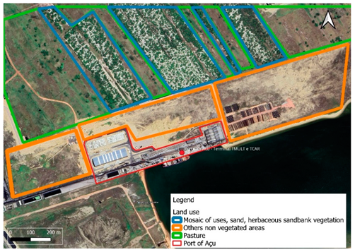 | As seen in the figure, the port is surrounded by expansive open areas, devoid of urban development or protected areas. Therefore, it merits a score of 10 points. City: Barra do Açu Coordinates (UTM SIRGAS 2000, Zone 24W): E 6.340.062/N 7.525.964 |
| Port of Murucupi (TUP 1) | 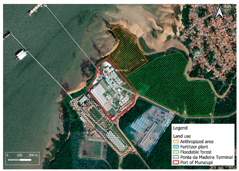 | The port is surrounded by the Ponta da Montanha Terminal in one side and by a fertilizer plant. It exhibits a clear area in one direction, obtaining a score of 5 points. City: Murucupi Coordinates (UTM SIRGAS 2000, Zone 22W): E 5.581.462/N 9.825.429 |
| Port of Santos (Public) |  | The Port of Santos is entirely situated within the limits of the city of Santos, with no potential for further development. City: Santos Coordinates (UTM SIRGAS 2000, Zone 23W): E 5.783.625/N 7.326.470 |
| Port | Image | Description |
|---|---|---|
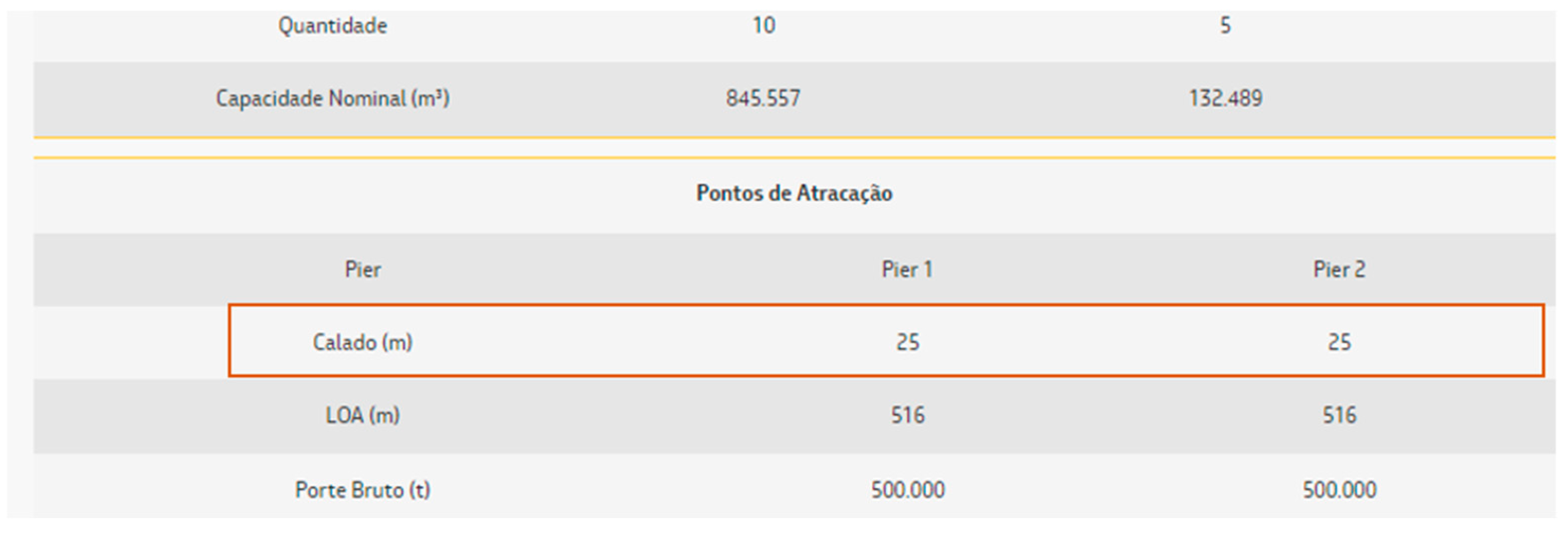
| Port of Pecém (TUP 1) | 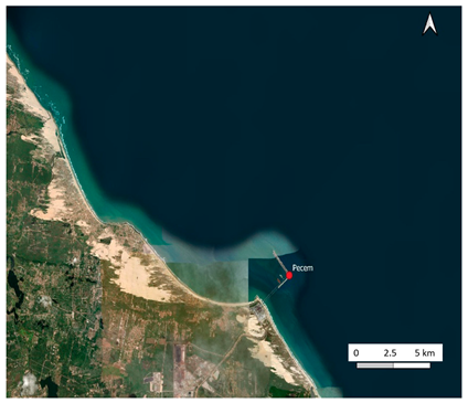 | Port of Pecém has artificial docks that serve as crucial infrastructure for handling various types of cargo, including containers, bulk commodities, and petroleum products. With a wide channel, free of obstacles and bends, navigating through the port is seamless, earning it a score of 10 points. City: Pecém Coordinates (UTM SIRGAS 2000, Zone 24W): E 6.689.600/N 9.595.700 |
| Port of Angra dos Reis (Public) | 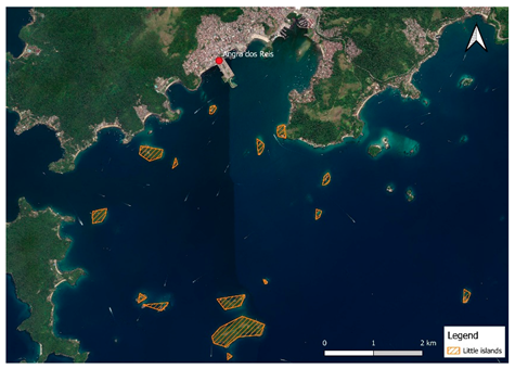 | The Port of Angra dos Reis faces moderate navigational challenges, encountering occasional obstacles along its waterways (i.e., little islands). Due to these factors, it is assigned a score of 5 points. City: Angra dos Reis Coordinates (UTM SIRGAS 2000, Zone 23W): E 5.991.834/N 7.421.560 |
| Companhia Portuária Vila Velha (TUP 1) | 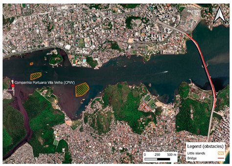 | Example of a port with severe navigational challenges, including a bridge and islands that generate obstacles. The presence of bridges and natural features complicates navigation, requiring precise maneuvering by ships to avoid collisions. This port obtained 0 points in this criterion. Companhia Portuária Vila Velha: City: Vila Velha Coordinates (UTM SIRGAS 2000, Zone 24W): E 6.426.841/N 7.692.589 |
| Port | Image | Description |
|---|---|---|
| Porto of Rio Grande (Public) | 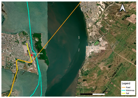 | Rail, road, and waterway inland networks are connected to the port, indicating all possibilities for transporting products arriving at the port. This port receives a score of 10 points. City: Rio Grande Coordinates (UTM SIRGAS 2000, Zone 22W): E 5.181.746/N 6.451.913 |
| Port of Itaqui (Public) | 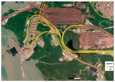 | Rail and road networks extend to the port, indicating comprehensive land connectivity. Therefore, the port receives a score of 7 points. City: São Luís Coordinates (UTM SIRGAS 2000, Zone 23W): E 6.071.139/N 9.710.933 |
| Port of Enseada Naval (TUP 1) | 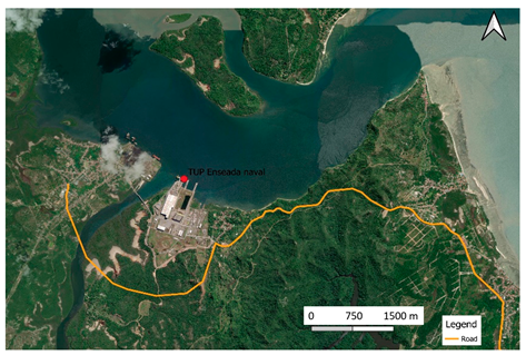 | The port is solely accessible by federal road, not by rail access or inland connections. In this scenario, with only road connectivity, the port receives a score of 5 points. City: Barra do Paraguaçu Coordinates (UTM SIRGAS 2000, Zone 24W): E 6.645.277/N 8.529.427 |
| Terminal Marítimo de Belmonte–TMB (TUP 1) | 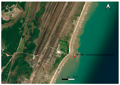 | The port lacks direct access to federal highways, railways, and waterway connexions. It received 0 points. City: Belmonte Coordinates (UTM SIRGAS 2000, Zone 24W): E 6.612.005/N 8.168.464 |
| Criteria | Factor | Percentage |
|---|---|---|
| Water depth | Deep draft capability | 12 |
| Moderate draft capability | 35 | |
| Limited draft capability | 53 | |
| Land capacity | Expansive land availability | 22 |
| Limited land availability | 39 | |
| Restricted land availability | 39 | |
| Dredging | Minimal dredging frequency | 46 |
| Moderate dredging frequency | 29 | |
| High dredging frequency | 25 | |
| Water accessibility | Optimal navigational challenges | 33 |
| Moderate navigational challenges | 18 | |
| Severe navigational challenges | 49 | |
| Land and water connectivity | Robust transportation connectivity | 3 |
| Adequate transportation connectivity | 14 | |
| Limited transportation connectivity | 45 | |
| Minimal transportation connectivity | 38 |
Disclaimer/Publisher’s Note: The statements, opinions and data contained in all publications are solely those of the individual author(s) and contributor(s) and not of MDPI and/or the editor(s). MDPI and/or the editor(s) disclaim responsibility for any injury to people or property resulting from any ideas, methods, instructions or products referred to in the content. |
© 2025 by the authors. Licensee MDPI, Basel, Switzerland. This article is an open access article distributed under the terms and conditions of the Creative Commons Attribution (CC BY) license (https://creativecommons.org/licenses/by/4.0/).
Share and Cite
Pimenta, A.M.; Puig, M.; Mallman, D.L.B.; Nóbrega, R.A.d.A.; Darbra, R.M. Unlocking Brazil’s Maritime Potential: Expanding Ports for Post-Panamax Operations. J. Mar. Sci. Eng. 2025, 13, 938. https://doi.org/10.3390/jmse13050938
Pimenta AM, Puig M, Mallman DLB, Nóbrega RAdA, Darbra RM. Unlocking Brazil’s Maritime Potential: Expanding Ports for Post-Panamax Operations. Journal of Marine Science and Engineering. 2025; 13(5):938. https://doi.org/10.3390/jmse13050938
Chicago/Turabian StylePimenta, Adriane Marques, Martí Puig, Danielle Laura Bridi Mallman, Rodrigo Affonso de Albuquerque Nóbrega, and R. M. Darbra. 2025. "Unlocking Brazil’s Maritime Potential: Expanding Ports for Post-Panamax Operations" Journal of Marine Science and Engineering 13, no. 5: 938. https://doi.org/10.3390/jmse13050938
APA StylePimenta, A. M., Puig, M., Mallman, D. L. B., Nóbrega, R. A. d. A., & Darbra, R. M. (2025). Unlocking Brazil’s Maritime Potential: Expanding Ports for Post-Panamax Operations. Journal of Marine Science and Engineering, 13(5), 938. https://doi.org/10.3390/jmse13050938