Article

Possibilities for Mitigating Coastal Erosion in the Downdrift Zone of Port Jetties Using Nearshore Nourishment: A Case Study of Klaipėda Port, Lithuania

by
Gintautas Žilinskas
1,
Rasa Janušaitė
1,
Darius Jarmalavičius
1,
Laurynas Jukna
2 and
Donatas Pupienis
1,*
1
Laboratory of Geoenvironmental Research, State Research Institute Nature Research Centre, Akademijos St. 2, 08412 Vilnius, Lithuania
2
Faculty of Chemistry and Geosciences, Vilnius University, 01513 Vilnius, Lithuania
*
Author to whom correspondence should be addressed.
J. Mar. Sci. Eng. 2025, 13(4), 628; https://doi.org/10.3390/jmse13040628
Submission received: 20 February 2025 / Revised: 17 March 2025 / Accepted: 19 March 2025 / Published: 21 March 2025
(This article belongs to the Section Marine Environmental Science)

Abstract

:
Coastal erosion hotspots frequently emerge in the downdrift zones of ports situated along open littoral drift seashores, often necessitating coastal protection measures. This study aims to evaluate the effectiveness of nearshore nourishment in mitigating coastal erosion using the downdrift zone of the Klaipėda Port (Baltic Sea) as a case study. In 2022, 79,390 m3 of sand was discharged at 2.0–3.5 depths at this site, forming an artificial sandbar parallel to the shoreline. The dynamics of the nourishment deposits were monitored for two years through beach and nearshore morphometric measurements and beach sand lithological composition sampling. Monitoring data indicated that the majority of the sand from the artificial sandbar migrated towards the subaerial coast, with minor depth variations also observed at depths of 4.0–5.6 m. Minor accretion in the nearshore was observed in regions beyond the designated nourishment area. The nearshore nourishment has successfully stabilised the subaerial coast at the discharge site for over two years, with 21.1% of the nourished sand accumulating on the subaerial coast and the shoreline position advancing seaward by an average of 10 metres. About 69.4% of the nourished sand remained at the nourishment site between the shoreline and the offshore boundary of the artificial sandbar, while approximately 9.5% was transported to the adjacent coast beyond the nourishment area.

1. Introduction

The intensifying and diverse human activities in coastal zones and ongoing climate change significantly impact coastal conditions in many regions around the world [1,2,3,4,5]. One human activity that often causes significant negative effects, including coastal erosion, is the construction, expansion, and operation of ports along exposed sandy coasts [6,7,8,9,10,11].
It has long been established that port jetties have a significant impact on natural coastal processes. On the updrift side of the jetties, a region of accretion occurs, while on the downdrift side, a region of erosion is typically observed. These processes are also characteristic of ports in the South-Eastern Baltic Sea region, including Władysławowo in Poland [11,12], Baltiysk in Russia, Kaliningrad Oblast [13], Klaipėda, and Šventoji in Lithuania [14,15], Liepāja and Ventspils in Latvia [16], and Pärnu in Estonia [17].
Both the natural environmental conditions around ports and the coastal erosion problems induced by port jetties on the downdrift side are very similar in this region. For example, in the 20th century, the maximum shoreline retreat on the downdrift side of Wladislawowo port reached 65–85 m [12]; for Šventoji, it reached 100–120 m [14], for Klaipėda, it reached 56–76 m [15], for Liepaja, it reached 80–130 m [16], and for Pärnu, it reached 80–140 m [17].
Substantial research has been conducted on the impact of port jetties on coastal changes [6,7,8,9,10,18,19]. As port infrastructure and urbanised areas often extend on both sides of port jetties, downdrift side erosion poses numerous challenges, in some cases, even for the existence of the jetty on the downdrift side. The most prevalent solutions to these issues have been the construction of hard engineering measures such as breakwaters, groynes, rock armour revetments or seawalls, which are designed to diminish wave energy but do not restore the subaerial coast. These measures are only a partial solution to the problem because they cause erosion hotspots to relocate to adjacent shores [20,21,22,23]. Furthermore, beaches are frequently degraded or even destroyed entirely as a consequence of hard measures. This has a particularly adverse effect on recreation and tourism, which boomed in the mid-20th century when beaches emerged as a major tourist attraction, significantly increasing their value [24,25].
In the mid-20th century, it was realised that the problem of downdrift side erosion could be mitigated by eliminating the barrier effect through sediment bypassing [8]. The most common method of implementing this solution involves discharging sand from the accreting updrift side or from the entrance channel (obtained during dredging or maintenance) to the downdrift side subaerial beach [1,26,27] or nearshore [28,29,30].
However, in cases where port entrance channels are dredged to such an extent that the adjacent nearshore depths are significantly shallower [15] than those within the entrance channel, nearshore nourishment on the eroded downdrift side is often viewed unfavourably. This is due to the perception that most of the sand used for nourishment will return to the entrance channel, necessitating more frequent dredging and increasing the financial resources required to maintain its operational depths.
The aim of this study was to determine whether nearshore nourishment could mitigate coastal erosion on the downdrift side of the port jetties, using Klaipėda Port in the Baltic Sea, Lithuania, as a case study, where an artificial sandbar in the nearshore of the downdrift side of the port was formed as a coastal stabilisation measure.

2. Study Area

The Port of Klaipėda is located in the southwestern part of the Baltic Sea, across the Klaipėda Strait (Figure 1A). A detailed characterisation of the natural environment of the Klaipėda Port area is presented in previous work [15]. Therefore, the present study will briefly review only the specific features of the downdrift side formation in the study area. As alongshore sediment transport along the Lithuanian coast is predominantly from south to north [28], the downdrift zone has emerged on the northern side of the Klaipėda Port jetties. As construction of the northern jetty of Klaipėda Port was initiated in 1834 (Figure 1B), the downdrift side experienced significant sediment accumulation, with the shoreline advancing seaward and the beach expanding to a width of 65–86 m. The most significant shoreline position changes were observed in proximity to the northern jetty and decreased from it in a northern direction (Figure 1B). During the construction of the northern jetty (1834–1878), the subaerial area along the 1300-m shoreline stretch north of the jetty increased by approximately 326,000 m2. The sediment accumulation was caused by the large northern shoals that existed offshore before the construction of the port jetties attaching to the shore [5].
As intensive accumulation was occurring on the subaerial coast and the shallow nearshore region (0–2 m depth), the shoreline advanced seaward (Figure 1B), while in the deeper nearshore, bed erosion began (Figure 1C). After the completion of the northern jetty in 1878, the shoreline stopped moving seaward. Shortly after, nearshore erosion on the downdrift side of the port’s northern jetty began, inducing subaerial beach erosion, which persists to the present day (Figure 1B,C). Figure 2 illustrates the temporal variability of erosion rates on the downdrift side of Klaipėda Port. Notably, the period between 1990 and 2004, when shoreline retreat in the study area halted and, in some sections, even shifted seaward, is attributed to the influence of sunken ships.
This hypothesis is supported by the documented sinking of a vessel in the vicinity of the study area. The cargo ship Rudolf Breitscheid, with a length of 142 m, sank in proximity to the distal end of the northern jetty in 1988. The parallel sinking of the ship extended the jetty in a northerly direction, thereby sheltering this coastal section from wind and waves [15]. The dismantling of the ships commenced in 1995, and by 2005, the removal of the last wreckage was completed. Consequently, shoreline retreat resumed and intensified following their removal [15]. The shoreline retreat was the most significant within the immediate 250 m from the jetty, with an estimated increase of up to 2.5 m/year (Figure 2).
Morphometric changes, determined from the bathymetric plans of 1910 and 2022, reveal that, within 1300 m of the jetty, the nearshore area north of the entrance channel (up to 10 m depth) and the subaerial coast have lost approximately 1.4 million m3 of sediment. The terrestrial area has been reduced by approximately 66,400 m2. Notably, the shore of the study area has evidenced the most intense erosion along the entire Lithuanian Baltic Sea coast over the past few decades [15,31].
Klaipėda, a port city with a population of over 156,000, attracts more than 250,000 beach users annually, which is approximately 1.6 times its resident population. However, the capacity of the beaches within the recreational area of Klaipėda is low. The recreational zone, with its relatively narrow beaches, extends only 5.6 km along the coast. The distribution of beach users in Klaipėda is limited by the Klaipėda Strait to the south and the Olando Cap Landscape Reserve to the north. The coast within the reserve is characterised by a narrow beach (8–15 m wide) covered with pebbles, gravel, and boulders, making it unsuitable for sunbathing or swimming.
For these reasons, the Lithuanian Coastal Management Programme (2014–2021) identified the need to mitigate coastal erosion on the downdrift side of Klaipėda Port. Because the beach in Klaipėda is a popular destination for both the city’s residents and tourists, hard engineering measures were ruled out, and it was decided to implement nearshore nourishment using the sand dredged from the Klaipėda Port entrance channel for stabilising the subaerial coast.
In addition to preserving the natural state of the coastal recreational environment, an important argument against using hard engineering measures for shoreline stabilisation was the desire to avoid severe damage caused by ship accidents. The Klaipėda port and adjacent sea area experience intense maritime traffic. Over the past 45 years, as many as seven ships have suffered accidents during storms, five of which were washed ashore and later successfully towed back to sea after the storms subsided. However, two significant incidents involved vessels that remained stranded for prolonged periods: in November 1981, the 170 m tanker Globe Asimi collided with the northern jetty at Klaipėda port entrance, and in September 1988, the cargo ship Rudolf Breitscheid sank near the northern jetty. Both vessels were removed only in 2005.
The tanker Globe Asimi accident had particularly devastating consequences for the coast, as 16,493 tonnes of fuel oil spilt into the sea and was driven ashore by prevailing westerly winds. During cleanup operations, more than 600,000 m3 of sand contaminated with oil were removed from beaches [32]. This led to significantly accelerated degradation of beaches and dunes along a 30 km stretch north of the port entrance [33].

3. Materials and Methods
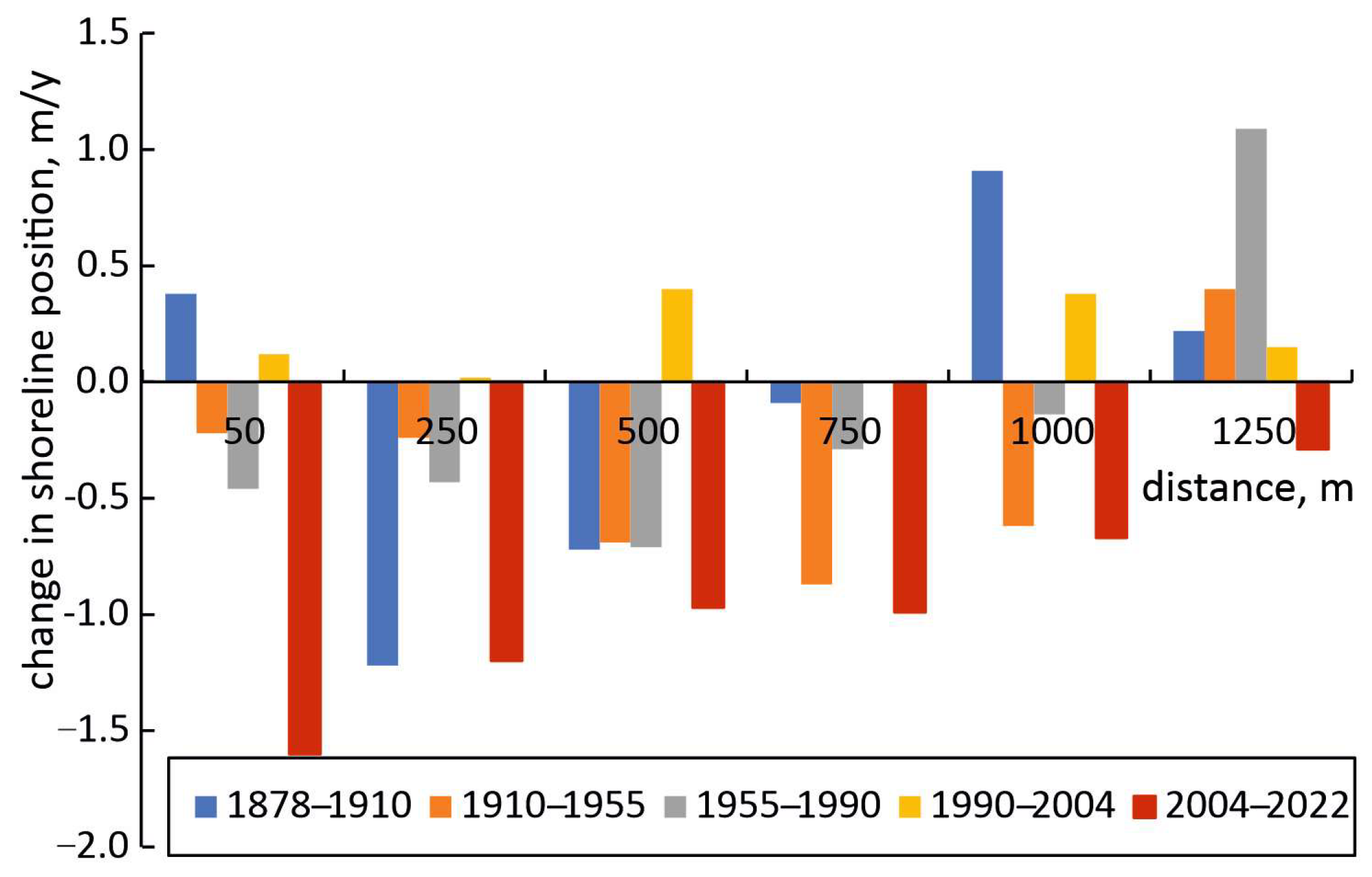
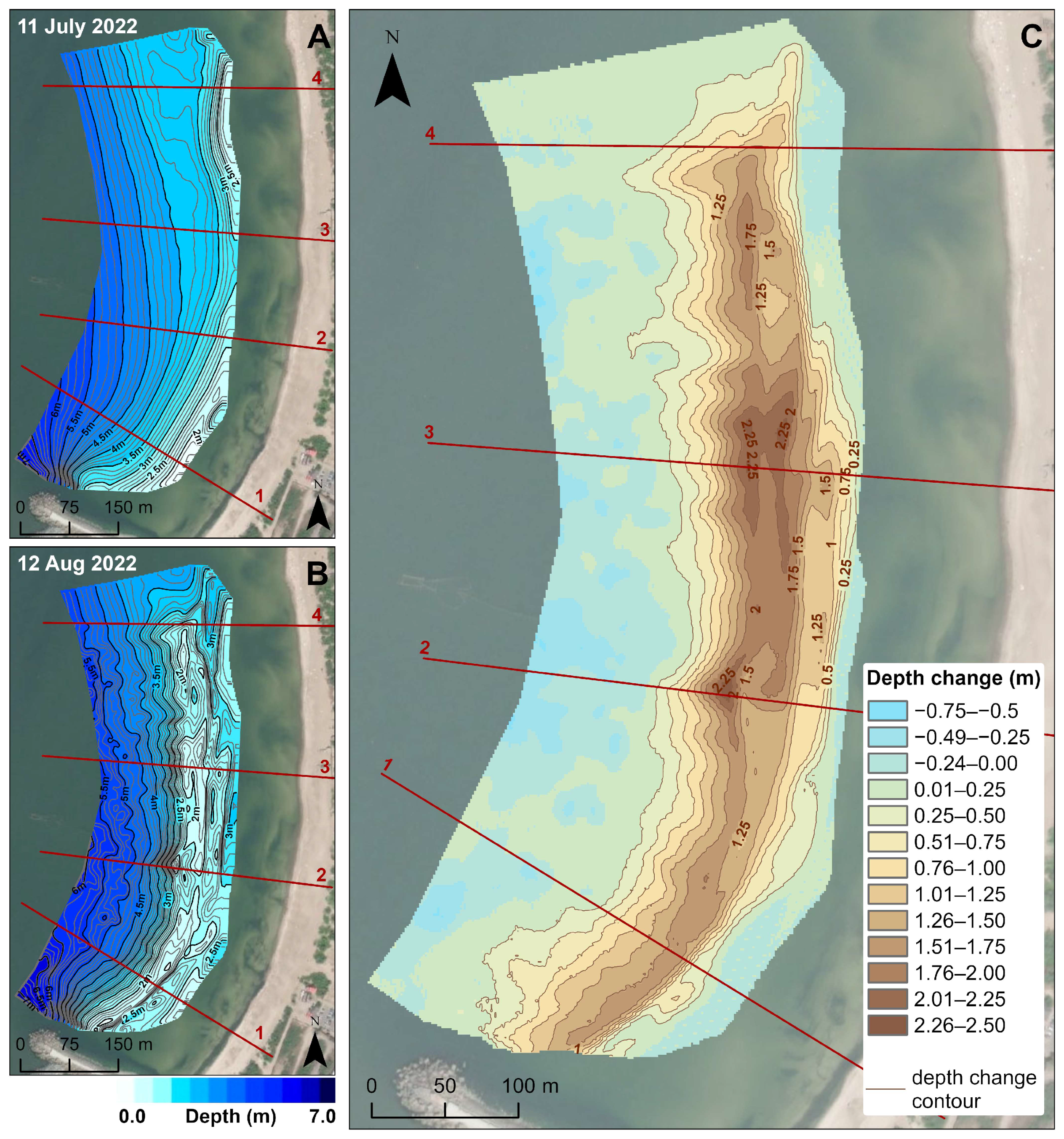
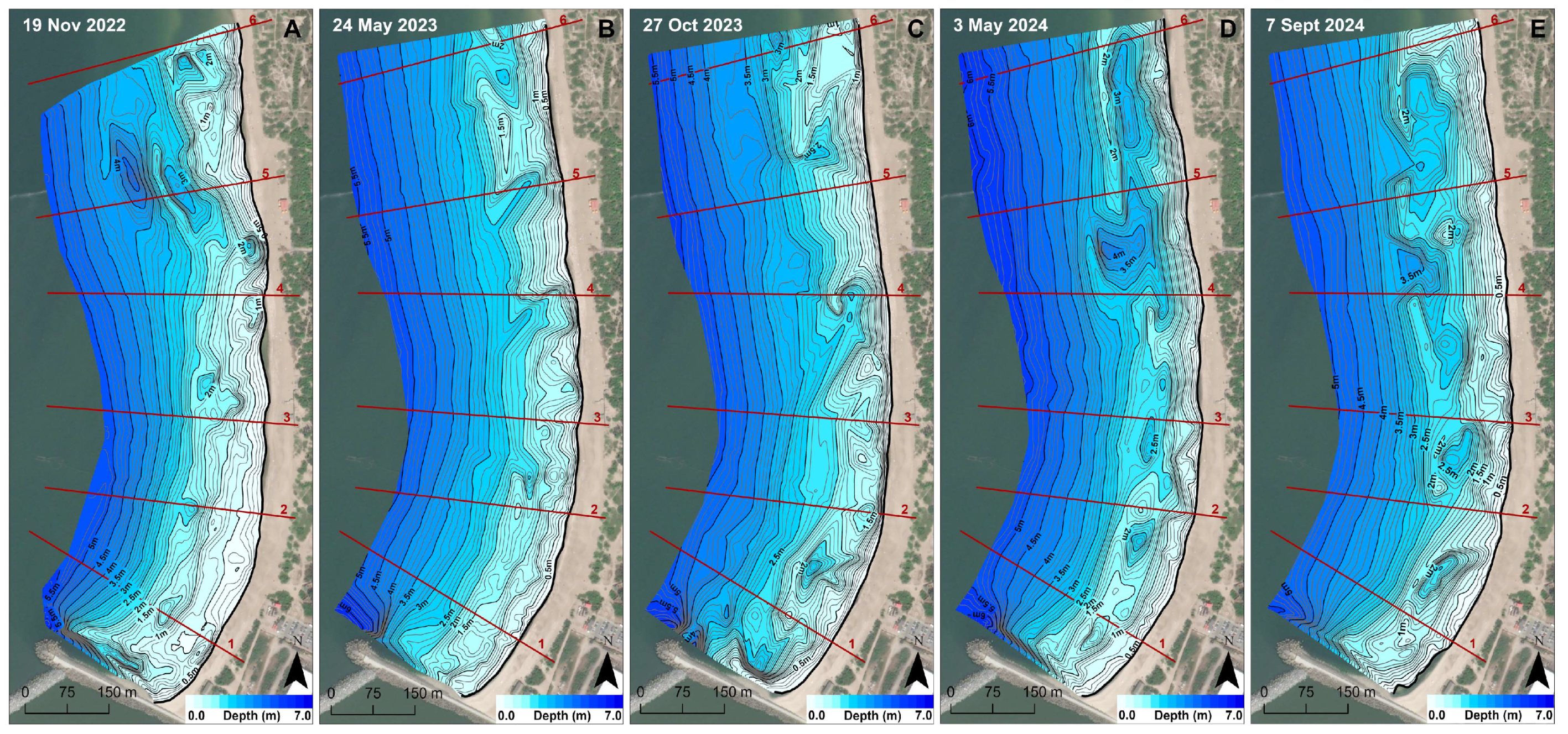
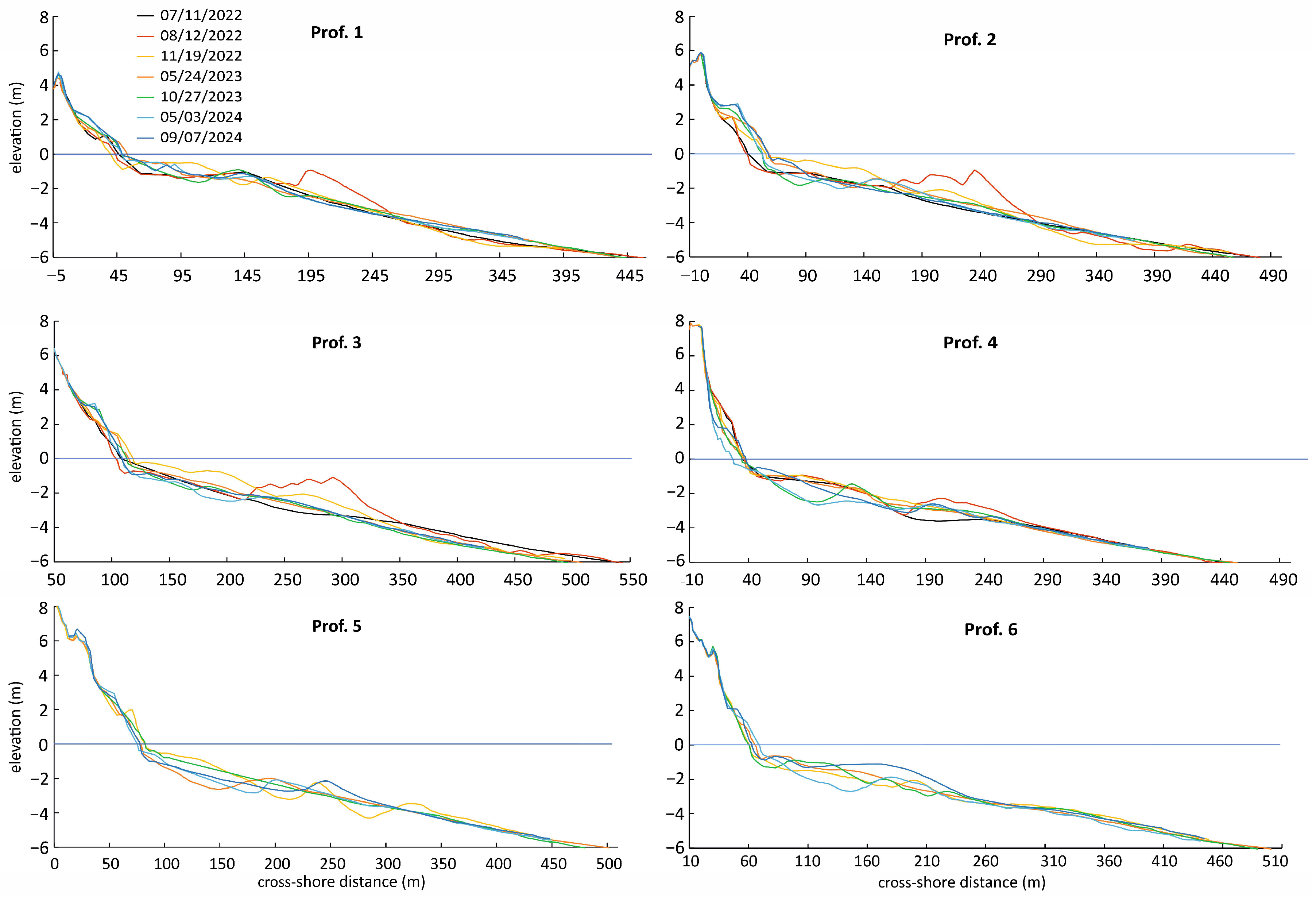
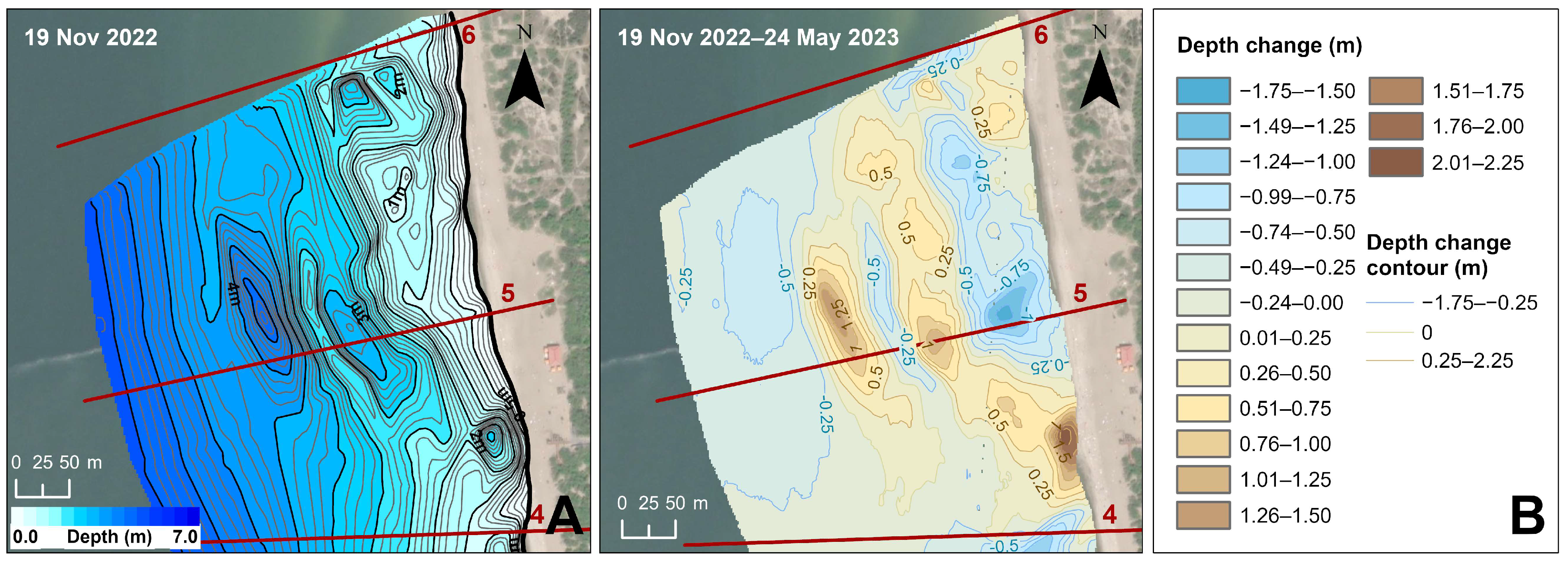
The study area was situated within a downdrift zone stretching approximately 1300 m alongshore to the north of the Klaipėda Port jetty (Figure 1A). The cross-shore length of the study area was defined by a foredune, beach, and nearshore region up to a depth of 6–7 m. For the analysis, the study area was divided into two sectors: the southern sector (S) and the northern sector (N). Sector S covered the area (218,000 m2) of artificial sandbar formation, while Sector N covered the area (172,000 m2) of potential sediment transport from the artificial sandbar (Figure 1A).
The present study investigates the impact of nearshore nourishment on the coastal zone, using a time series of pre- and post-nourishment bathymetric, beach cross-shore levelling, and sediment composition data obtained between 2022 and 2024. Bathymetric measurements were performed using a dual-beam echosounder, the Humminbird Helix 9 (Johnson Outdoors, Inc., Eufaula, AL, USA). Beach cross-shore profiles were obtained using GNSS Topcon HiPer SR (Topcon Positioning Systems, Inc., Livermore, CA, USA) at six locations along the study area (Figure 1A).
Measurements in Sector S were carried out before the nourishment on 11 July 2022 and on six different dates over the two years following nourishment: 12 August 2022, 19 November 2022, 24 May 2023, 27 October 2023, 3 May 2024, and 7 September 2024. In Sector N, the initial measurements were performed on 19 November 2022. All measurements were tied to the Baltic Normal Height System 1977.
Shoreline dynamics and nearshore depth changes during different periods were analysed using ReefMaster 2.0 and ArcGIS Pro 3.3 software. Samples for sediment pre-nourishment composition analysis were collected from the surface of the nearshore sand dredging and nourishment sites, as well as from the subaerial beach next to the nourishment area. Post-nourishment sediment samples were collected exclusively from the subaerial beach and were mechanically sieved using a vibratory sieve shaker Fritsch Analysette 3 Spartan Pulverisette 0.

4. Results

4.1. Nourishment Data Analysis

The nearshore nourishment was executed utilising the “rainbow” method from 29 July 2022 to 11 August 2022. The artificial sandbar formation during nourishment resulted in the discharge of a total volume of 182,368 m3. The morphology of the artificial sandbar is illustrated in Figure 3. The amount of discharged sand is the primary factor for analysing the effectiveness of nourishment on coastal processes [34]. However, the data provided by the nourishment operators did not correspond to the amount of sand found at the nourishment site after discharge, as the rainbow nourishment method involves spraying sand with water. Bathymetric surveys indicated that the total volume of discharged sand was 79,390 m3 (representing 43.5% of the volume declared by the contractor). This quantity was utilised in the analysis.

4.2. Post-Nourishment Sediment Transport in the Nearshore Zone

The study period was not characterised by significant storminess, with wind gusts rarely exceeding 20 m/s and a sea level rarely exceeding 100 cm above the annual mean sea level. However, periods of calm weather (spring–summer) and stormier conditions (autumn–winter) did occur (Figure 4). Figure 5 illustrates the general spatiotemporal changes in the nearshore bathymetry of the study area after the nourishment, though trends in sediment transport in the nearshore zone after nourishment are better reflected in a time-series of the nearshore cross-shore profiles, as shown in Figure 6. The most significant nearshore changes (Figure 6, prof. 1–3) occurred within the first three months post-nourishment despite the relatively calm weather conditions in August and September 2022 (Figure 4). Between 12 August 2022 and 19 November 2022, sediments discharged at 2–3.5 m depths in Sector S were predominantly transported to shallower depths of 0.0–2.0 m, with a small amount reaching the subaerial coast (Figure 6, Table 1).
Meanwhile, at 4.0–5.5 m depths, an increase in nearshore depth was observed (Figure 6, prof. 1–3), likely due to high wave transformation on the seaward side of the artificial sandbar where depths abruptly dropped. As the prominent sandbar crest at the discharge site dissipated, depths at this location relatively recovered. This was not observed in Sector N (Figure 6, prof. 5–6).
It is also interesting that during this period, the sand volume on the S sector’s nearshore did not decrease but instead increased (Table 1). In Sector N, 80 m north of profile 4 (Figure 7A), a deep bay formed at the beach during the November 2022 storms. The formation of this bay was related to the nearshore morphological features, including a notable increase in the nearshore depths extending seaward from the shoreline towards the NW, as shown on the bathymetric map of 19 November 2022 (Figure 7A). In this area, the rip currents significantly increased the depth of the upper nearshore, completely eroding the beach and substantially degrading the foredune. North–north-westerly winds that prevailed at this time transported sediment from the subaerial coast to Sector S nearshore, resulting in a substantial sediment volume increase (over 30,800 m3) in Sector S (Table 1).
On 24 May 2023, nine months after the nourishment and following a stormy autumn–winter season (Figure 4), when wind speeds and sea levels exceeded significant levels (> 20 m/s, sea level ≥ 1 m) on multiple dates, the artificial sandbar crest was dissipated, and the sandbar lost its continuity (Figure 6). The artificial sandbar became discontinuous due to the rip-current activity. In Sector S, the most significant changes in the nearshore morphology were observed between the shoreline and the 3.5 m depth. Sediments were also transported alongshore to Sector N. In this sector, sediments moved not only alongshore but also deeper offshore in an NW direction, as evidenced by the bottom changes in the nearshore area between profiles 4 and 6 (Figure 7B). Bathymetric survey data acquired on 24 May 2023 demonstrate that the pits present north of profile 4 before and on 22 November 2022 (Figure 7A) were filled by the NW sediment transport (Figure 7B).
The data show (Table 1) that, between 19 November 2022 and 24 May 2023, the nearshore of Sector S lost the largest amount of sand (44,500 m3) during the entire study period. However, most of this loss occurred because sediments transported here from Sector N between 12 August 2022 and 19 November 2022 were returned to Sector N (Figure 7B). The bathymetric map of 24 May 2023 (Figure 7B) shows that a sandy shoal formed north of profile 4, replacing the nearshore bay observed here on 19 November 2022 (Figure 7A). The beach not only recovered but also widened, with partial foredune regeneration. During this period, the subaerial beach of Sector S experienced the greatest accumulation of sand during the study period (Figure 8, Table 1).
An even greater fragmentation of nearshore morphology was observed 1.5 years after the nourishment and later (Figure 5). Between 3 May 2024 and 7 September 2024, significant accumulation occurred on both the subaerial coast and nearshore areas of the entire study area (S and N sectors) (Table 1). In the nourishment area (Sector S), this could be attributed to the migration of nourished sediments, but the notable increase in Sector N likely resulted from the southward migration of over 188,000 m3 of sand dumped along a 3.1 km nearshore stretch 1.5 km north of the study area in April–May 2024.
A time lag is observed between onshore sediment transport from the artificial sandbar and its accumulation on the subaerial coast. While the most intense nearshore-to-subaerial-coast sand movement occurred within three months of nourishment, the maximum accumulation on the subaerial coast was observed nine months post-nourishment (Table 1).
As mentioned in Section 2, Sector S has been subject to severe coastal erosion for decades, exhibiting seasonal variations in the shoreline position and sediment volume on the subaerial coast, with increased coastal erosion in autumn-winter and decreased or stabilised erosion in spring-summer. These seasonal patterns of coastal changes have long been recognised on sandy shores [35,36,37]. However, post-nourishment subaerial coast sediment volume in Sector S increased regardless of season (Table 1).
The nearshore nourishment stabilised the subaerial coast at the site of the discharge for more than two years, with 21.1% (16,730 m3) of the nourished sand accumulated on the subaerial coast, 69.4% (55,110 m3) remaining in the nourishment site (Sector S) nearshore, and 9.5% (7550 m3) transported to the adjacent Sector N.

4.3. Post-Nourishment Changes in the Beach Sand Grain Size

Changes in the sand grain size composition further confirm that the post-nourishment increase in beach sediment volume resulted from discharged sediment accumulation. In the study area before nearshore nourishment, the beach consisted of coarse-grained sand [15,31,38] with an average grain size of 0.51 mm, and the sand particle distribution curve with two modes was 0.2–0.315 and 0.4–0.63 mm. Meanwhile, nearly three months post-nourishment, fine-grained sands (0.2–0.315 mm, mean 0.24 mm) dominated the beach, and the coarse-grained sand mode disappeared (Figure 9).
Subsequently, fine-grained sands accumulated from the nearshore mixed with local coarse-grained sands, increasing the proportion of coarse-grained sands compared to fine-grained sands. Two years after nearshore nourishment, the beach sand had a mean grain size of 0.44 mm, again with two modes. However, a comparison of the sand grain size composition before and two years after nearshore nourishment shows that the proportion of fine-grained sand is now higher than that of coarse-grained sand (Figure 9).

5. Discussion

5.1. Nearshore vs. Beach Nourishment

The decision to implement nearshore nourishment instead of beach nourishment in the downdrift zone north of Klaipėda Port was determined by several factors. Previous studies and coastal management projects have proven that the most effective nourishment result is attained when the borrowed material is comparable to, or only slightly coarser than, the native material [39,40,41]. A comparison of sand samples collected from the designated excavation site with nearshore and beach samples from the Klaipėda Port downdrift zone revealed that the grain size composition of the borrow material closely resembled that of the nearshore environment, as opposed to the beach sand, which exhibited a significantly finer grain size distribution (mean grain size: 0.18 mm) than the excavated sand. The native sand in the nearshore area had a fine grain size distribution (0.20 mm), while the beach sand displayed a coarse grain size distribution (0.51 mm).
A further rationale pertains to the nourishment cost, with nearshore nourishment being less expensive than the subaerial one [42]. Dutch researchers estimated the cost at 3.5 EUR/m3 for nearshore nourishment compared to 5.5 EUR/m3 for beach nourishment. They further posit, “beach nourishments have the shortest lifespan (~3 years), but the sand is placed directly where it is needed the most for the dynamic conservation of the coastline. Shoreface nourishments have a longer lifespan (4–10 years), but it takes a few years before they have an effect on the shoreline position” [35]. Moreover, as the nourishment was implemented during the peak of the recreational season (July–August), nearshore nourishment was found to be more acceptable and less intrusive than beach nourishment.
It should also be noted that, in the case of Klaipėda port, implementing nourishment in the nearshore area adjacent to the port resulted in significant positive economic and even partially ecological effects. Previously, sand dredged from the port’s entrance channel was dumped offshore in an open-sea dumping area located approximately 10–11 km from the port. However, the current nourishment site is only 0.3–0.7 km away from the dredging location, leading to clearly substantial economic and even ecological benefits, including significantly reduced fuel consumption by barges.

5.2. The Influence of Nourishment on the State of the Beach

The shoreline position in the nourished area (Sector S) shifted seaward by an average of 10 metres over two years following the nourishment. The most significant seaward shift (18 m) was observed in the central area of Sector S (the most intensely eroded section prior to nourishment), with considerably smaller seaward shifts (6.0 m) observed at the periphery of Sector S (Table 2). Additionally, minor seaward shoreline changes (4 m) were identified at the southernmost measurement point of Sector N (Sector N, 790 m from the jetty). Furthermore, a retreat of approximately 17 and 8 metres was observed further to the north (1020 m and 1300 m from the jetty, respectively) (Table 2).
Analogous patterns of shoreline changes were observed in the fluctuations of sand volume on the subaerial coast. In Sector S, an average of 25.1 m3/m of sand was deposited over a period of two years, with the maximum accumulation of 41.9 m3/m in the central part of Sector S (Table 3). While the majority of this sediment was deposited on the beach, it also contributed to the nourishment of the foredune sand budget (Figure 6). In Sector N, with the exception of the northernmost part (1300 m from the jetty), the sand volume on the subaerial coast decreased by an average of 21.5 m3/m.
The decrease in depth in the upper foreshore part between the shoreline and the 4-metre depth had the greatest impact on coastal stabilisation in the study area after nourishment. Small depth changes were also detected between the 4.0 and 5.6 m isobaths. As the nearshore depths decrease, waves undergo greater dissipation in the surf zone during storms, resulting in lower energy waves reaching the coast [43,44]. Significant wave height directly determines the level of the wave set-up and, consequently, the width of the beach flooded during storms. Therefore, the shallowing of the nearshore led to a decrease in the intensity of coastal erosion. It should be noted that no significant changes in the nearshore bottom below 5.6 m were observed during the study period. Thus, at least for now, the movement of borrowed material to greater depths, and thereby into the entrance channel, has not been detected.
The comparatively limited amount (79,390 m3) of the nourishment sand is insufficient to compensate for the 1.4 million m3 of sand lost by the downdrift zone since the construction of the Klaipėda Port jetties (Section 2). Nevertheless, even a small amount of sand has stabilised the coast at the discharge site for more than two years.

5.3. Selection of the Optimal Nourishment Depth and Artificial Sandbar Morphology

The selection of the optimal depth for nearshore nourishment is crucial, as the efficiency of nourishment depends on both the depth and the amount of sediment discharged [35]. The sand dumping depth for the nourishment site analysed in this study was determined based on previous research findings [45]. In 2001, over 537,000 m3 of sand was dumped on the foreshore between 3 and 5 km north of the Klaipėda Port jetty. In part of the foreshore nourishment area, sand was dumped at depths of 3.5–4.5 m, while in another area, it was discharged at depths of 5.0–6.5 m. Seven months after the dumping, 61.2% of the sand dumped at 3.5–4.5 m depths had migrated towards the subaerial coast and was localised between the shoreline and the 3.5 m depth, as well as on the subaerial coast. Conversely, sand dumped at depths of 5.0–6.5 m showed minimal shoreward transport and thus did not significantly contribute to coastal stabilisation [45]. Similar results were obtained in the Netherlands, where nourishment at greater nearshore depths in Heemskerke (6 m) and Callantsoog (7 m) had no significant positive effects on the subaerial coast [46]. These findings informed the decision to conduct nourishment at depths between 2.0 and 3.5 m for the Klaipėda Port downdrift site, with the aim of maximising sand transportation towards the subaerial coast and minimising sand displacement to deeper waters and the entrance channel. The results of this study confirm that the chosen nearshore nourishment depth was effective.
To ensure the maximum possible sand transport towards the subaerial coast after the nourishment, a continuous artificial sandbar was formed, rather than separate sand ridges, which could induce rip currents between them, leading to the transport of the nourished sand to greater depths immediately after the nourishment. The results of this study indicate that the decision to form a continuous artificial sandbar was successful. During the first three months after the nourishment, the sandbar migrated onshore while maintaining its integrity, aided by relatively calm weather during that period. However, nine months, and especially 1.5–2 years post-nourishment, the artificial sandbar was fragmented into a series of bays and sandbar horns. Modelling results further indicate that continuous sandbars, at the same nourishment levels, dissipate wave energy better than individual discontinuous ridges [28], suggesting that continuous sandbar shape is more effective for mitigating coastal erosion than multiple discontinuous sand ridges.

6. Conclusions

The nearshore nourishment experiment, which entailed the construction of an artificial sandbar in the downdrift zone of Klaipėda port jetties, successfully stabilised the subaerial coast over an extended period. A portion of the discharged sand accumulated on the coast, resulting in a noticeable seaward shift of the shoreline, with the most significant changes identified in the areas most affected by erosion. Sand accumulation occurred during both calm and stormy conditions, with the most intense sediment transport occurring shortly after nearshore nourishment and maximum accumulation occurring later.
A substantial reduction in depth in the upper nearshore contributed to protecting the shore from wave action during storms. Sediment transport remained primarily between shallow nearshore areas and the subaerial beach, with minimal changes observed in deeper nearshore zones.
Despite the success of this strategy, the amount of sand displaced was insufficient to address the larger issue of sand loss caused by shoreline retreat during the 19th and 20th centuries. Continued nearshore nourishment efforts are anticipated to support shoreline reclamation, enhance the recreational beach area, and contribute to foredune regeneration. These measures would also provide a proactive response to the challenges posed by climate change.
In the case of Klaipėda port, conducting nourishment in the nearshore area adjacent to the port produced significant positive economic and even partially ecological effects. Previously, sediment dredged from the entrance channel was disposed of in an open-sea dumping site located 10 km offshore. However, the current nourishment location is just 0.3–0.7 km from the dredging site, leading to clearly substantial economic and ecological benefits, particularly due to significantly reduced barge fuel consumption. We observed the only problematic aspect regarding nearshore nourishment implementation is reconciling recreational interests with coastal management activities. Conducting larger-scale nourishment in shallow nearshore areas requires relatively longer periods (10–14 days) of calm weather, which typically coincide with the recreational season in the Klaipėda port region.

Author Contributions

Conceptualisation, G.Ž. and D.J.; methodology, G.Ž., D.J. and D.P.; software, R.J., D.P. and L.J.; validation, R.J., D.J. and D.P.; formal analysis, G.Ž.; investigation, G.Ž., L.J., D.J. and D.P.; resources, G.Ž.; data curation, G.Ž., R.J., D.J. and L.J.; writing—original draft preparation, G.Ž., R.J., D.J. and D.P.; writing—review and editing, G.Ž., R.J., D.J. and D.P.; visualisation, R.J., D.J. and D.P.; supervision, G.Ž. and D.J.; project administration, D.P.; funding acquisition, G.Ž. All authors have read and agreed to the published version of the manuscript.

Funding

This research received no external funding.

Data Availability Statement

The original contributions presented in this study are included in the article. Further inquiries can be directed to the corresponding author.

Acknowledgments

We are grateful to Rasa Davitaia of the Dredging Division of Klaipėda State Seaport for providing data on the scope of dredging works.

Conflicts of Interest

The authors declare no conflicts of interest.

References

  1. Spodar, A.; Héquette, A.; Ruz, M.H.; Cartier, A.; Grégoire, P.; Sipka, V.; Forain, N. Evolution of a beach nourishment project using dredged sand from navigation channel, Dunkirk, northern France. J. Coast. Conserv. 2018, 22, 457–474. [Google Scholar] [CrossRef]
  2. Marinho, B.; Carlos Coelho, C.; Magnus Larson, M.; Hans Hanson, H. Monitoring the evolution of nearshore nourishments along Barra-Vagueira coastal stretch, Portugal. Ocean Coast. Manag. 2018, 157, 23–39. [Google Scholar] [CrossRef]
  3. Luijendijk, A.; Hagenaars, G.; Roshanka Ranasinghe, R.; Baart, F.; Donchyts, G.; Aarninkhof, S. The State of the World’s Beaches. Sci. Rep. 2018, 8, 6641. [Google Scholar] [CrossRef]
  4. Lämmle, L.; Perez Filho, A.; Donadio, C.; Arienzo, M.; Ferrara, L.; Santos, C.d.J.; Souza, A.O. Anthropogenic Pressure on Hydrographic Basin and Coastal Erosion in the Delta of Paraíba do Sul River, Southeast Brazil. J. Mar. Sci. Eng. 2022, 10, 1585. [Google Scholar] [CrossRef]
  5. Chowdhury, P.; Lakku, N.K.G.; Lincoln, S.; Seelam, J.K.; Behera, M.R. Climate change and coastal morphodynamics: Interactions on regional scales. Sci. Total Environ. 2023, 899, 166432. [Google Scholar]
  6. Brunn, P. The Development of Downdrift Erosion. J. Coast. Res. 1995, 11, 1242–1257. [Google Scholar]
  7. Elmoustapha, A.O.; Levoy, F.; Manfort, O.; Koutitonsky, V.G. A numerical forecast of shoreline evolution after harbour construction in Nouakchott, Mauritania. J. Coast. Res. 2007, 236, 1409–1417. [Google Scholar] [CrossRef]
  8. Pupienis, D.; Jonuškaitė, S.; Jarmalavičius, D.; Žilinskas, G. Klaipėda port jetties impact on the Baltic Sea shoreline dynamics, Lithuania. J. Coast. Res. 2013, 165, 2167–2172. [Google Scholar] [CrossRef]
  9. Lim, K.C.H.; Hwang, S.; Lee, J.L. An analytical model for beach erosion downdrift of groins: Case study of Jeongdongjin Beach. Earth Surf. Dyn. 2022, 10, 151–163. [Google Scholar] [CrossRef]
  10. Franklin, G.L.; Medellin, G.; Appendini, C.H.M.; Gómez, J.A.; Torres-Freyermuth, A.; González, J.L.; Ruiz-Salcines, P. Impact of port development on the northern Yucatan Peninsula coastline. Reg. Stud. Mar. Sci. 2021, 45, 101835. [Google Scholar] [CrossRef]
  11. Szmytkiewicz, M.; Biegowski, J.; Kaczmarek, L.M.; Okroj, T.; Ostrowski, R.; Pruszak, Z.; Rozynsky, G.; Skaja, M. Coastline changes nearby harbour structures: Comparative analysis of one-line models versus field data. Coast. Eng. 2000, 40, 119–139. [Google Scholar]
  12. Pruszak, Z. Polish coast—Two cases of human impact. Baltica 2004, 17, 34–40. [Google Scholar]
  13. Babakov, A.N.; Chuburenko, B.V. The Structure of the Net Alongshore Sediment Transport in the Eastern Gulf of Gdansk. Water Resour. 2019, 46, 515–529. [Google Scholar] [CrossRef]
  14. Kriaučiūnienė, J.; Žilinskas, G.; Pupienis, D.; Jarmalavičius, D.; Gailiušis, B. Impact of Šventoji port jetties on coastal dynamics of the Baltic Sea. J. Environ. Eng. Landsc. Manag. 2013, 21, 114–122. [Google Scholar] [CrossRef]
  15. Žilinskas, G.; Janušaitė, R.; Jarmalavičius, D.; Pupienis, D. The impact of Klaipėda Port entrance channel dredging on the dynamics of coastal zone, Lithuania. Oceanologia 2020, 62, 489–500. [Google Scholar] [CrossRef]
  16. Eberhards, G.; Lapinskis, J. Processes on the Latvian Coast of the Baltic Sea; Atlas: Riga, Latvia, 2008. [Google Scholar]
  17. Tönisson, H.; Mannikus, R.; Kont, A.; Palginomm, V.; Alari, V.; Suuroja, S.; Vaasma, T.; Vilumaa, K. Application of Shore Sediments Accumulated in Navigation Channel for Restoration of Sandy Beaches around Parnu City, SW Estonia, Baltic Sea. J. Mar. Sci. Eng. 2024, 12, 394. [Google Scholar] [CrossRef]
  18. Balaji, R.; Kumar, S.S.; Misra, A. Understanding the effects of seawall construction using a combination of analytical modelling and remote sensing techniques: Case study of Fansa, Gujarat, India. J. Ocean Clim. Syst. 2017, 8, 153–160. [Google Scholar] [CrossRef]
  19. Tang, J.; Lyu, Y.; Shen, Y.; Zhang, M.; Su, M. Numerical study on influences of breakwater layout on coastal waves, wave-induced currents, sediment transport and beach morphological evolution. Ocean Eng. 2017, 141, 375–387. [Google Scholar] [CrossRef]
  20. Basinski, T. Protection of the Hel Spit. J. Coast. Res. 1995, 22, 197–201. [Google Scholar]
  21. Losada, M.A.; Medina, R.; Vidal, C.; Losada, I.J. History of coastal engineering in Spain. In History and Heritage of Coastal Engineering; American Society of Civil Engineers: Reston, VA, USA, 1996; pp. 465–499. [Google Scholar]
  22. Hamm, L.; Capobianco, M.; Dette, H.H.; Lechuga, A.; Spanhoff, R.; Stive, M.J.F. A summary of European experience with shore nourishment. Coast. Eng. 2002, 47, 237–264. [Google Scholar] [CrossRef]
  23. Wang, Y.H.; Wang, Y.H.; Deng, A.J.; Feng, H.C.; Wang, D.W. Emerging Downdrift Erosion by Twin Long-Range Jetties on an Open Mesotidal Muddy Coast, China. J. Mar. Sci. Eng. 2022, 10, 570. [Google Scholar] [CrossRef]
  24. Saengsupavanich, C. Willingness to restore jetty-created erosion at a famous tourism beach. Ocean Coast. Manag. 2019, 178, 104817. [Google Scholar] [CrossRef]
  25. Bax, V.; van de Lageweg, W.I.; de Groot, S.; Moerbeek, W. Beach user perspectives on the upscaling of sand nourishments in response to sea level rise—A discrete choice experiment. Ocean Coast. Manag. 2024, 253, 107139. [Google Scholar] [CrossRef]
  26. Nordstrom, K.F.; Jackson, N.L.; Farrell, E.J.; Rafferty, P.; Tengwall, C. Restoring sediment to compensate for human-induced erosion of an estuarine shore. Geomorphology 2016, 262, 37–46. [Google Scholar] [CrossRef]
  27. Ludka, B.C.; Guza, R.T.; O’Reilly, W.G. Nourishment evolution and impacts at four southern California beaches: A sand volume analysis. Coast. Eng. 2018, 136, 96–105. [Google Scholar] [CrossRef]
  28. Johnson, C.L.; McFall, B.C.; Krafft, D.R.; Brown, M.E. Sediment Transport and Morphological Response to Nearshore Nourishment Projects on Wave-Dominated Coasts. J. Mar. Sci. Eng. 2021, 9, 1182. [Google Scholar] [CrossRef]
  29. Mendes, D.; Pais-Barbosa, J.; Baptista, P.; Silva, P.A.; Bernardes, C.; Pinto, C. Beach Response to a Shoreface Nourishment (Aveiro, Portugal). J. Mar. Sci. Eng. 2021, 9, 1112. [Google Scholar] [CrossRef]
  30. Pinto, C.A.; Taborda, R.; Andrade, C.; Baptista, P.; Silva, P.A.; Mendes, D.; Pais-Barbosa, J. Morphological Development and Behaviour of a Shoreface Nourishment in the Portuguese Western Coast. J. Mar. Sci. Eng. 2022, 10, 146. [Google Scholar] [CrossRef]
  31. Jarmalavičius, D.; Žilinskas, G.; Pupienis, D. Impact of Klaipėda port jetties reconstruction on adjacent sea coast dynamics. J. Environ. Eng. Landsc. Manag. 2012, 20, 240–247. [Google Scholar] [CrossRef]
  32. Pustelnikovas, O.; Nesterova, M. Environmental Effects of aBlack Oil Spill in the Baltic Sea. Biogeochemistry, Geology and Paleogeography of the Baltic Sea Series; Academy of Sciences of the Lithuanian SSR Department of Geography; Academy of Sciences of the USSR P. Shirshov Institute of Oceanology: Vilnius, Lithuania, 1984; Volume 2. [Google Scholar]
  33. Kirlys, V. Impact of extreme storms on the shallow and sandy coasts of the South-Eastern Baltic. Coast. Dyn. Paleogeography Balt. Sea 1990, 1, 83–96. [Google Scholar]
  34. Brand, E.; Ramaekers, G.; Lodder, Q. Dutch experience with sand nourishments for dynamic coastline conservation—An operational overview. Ocean Coast. Manag. 2022, 217, 106008. [Google Scholar] [CrossRef]
  35. King, C.A.M. Beaches and Coasts; Arnold: London, UK, 1959. [Google Scholar]
  36. Winant, C.D.; Inman, D.L.; Nordstrom, C.E. Description of seasonal beach changes using empirical eigenfunctions. J. Geophys. Res. 1975, 80, 1979–1986. [Google Scholar]
  37. Hallermeier, R.J. A profile zonation for seasonal sand beaches from wave climate. Coast. Eng. 1980, 4, 253–277. [Google Scholar] [CrossRef]
  38. Žilinskas, G.; Jarmalavičius, D.; Pupienis, D. The influence of natural and anthropogenic factors on grain size distribution along the southeastern Baltic spits. Geol. Q. 2018, 62, 375–384. [Google Scholar] [CrossRef]
  39. James, W.R. Techniques in Evaluating Suitability of Borrow Material for Beach Nourishment; U.S. Army Corps of Engineers Coastal Engineering Research Center: Vicksburg, MS, USA, 1975; Volume 60. [Google Scholar]
  40. Shore Protection Manual; Coastal Engineering Research Center. US. Army Corps of Engineers, Waterways Experiment Station: Vicksburg, MS, USA, 1984.
  41. Dean, R.G.; Campbell, T.J. Beach nourishment. In Handbook of Ocean Engineering; Springer: Berlin/Heidelberg, Germany, 2016; pp. 635–652. [Google Scholar] [CrossRef]
  42. Van der Spek, A.J.F.; de Kruif, A.C.; Spanhoff, R. Guidelines for Shoreface Nourishments; RIKZ-rapport; Rijswaterstaat: Utrecht, The Netherlands, 2007; ISBN 978-90-369-5764-9. (In Dutch) [Google Scholar]
  43. Maa, J.P.-Y.; Hobbs, C.H.; Hardaway, C.S., Jr. A criterion for determining the impact on shorelines caused by altering wave transformation. J. Coast. Res. 2001, 17, 107–113. [Google Scholar]
  44. Work, P.A.; Fehrenbacher, F.; Voulgaris, G. Nearshore impacts of dredging for beach nourishment. J. Waterw. Port Coast. Ocean Eng. 2004, 130, 303–311. [Google Scholar] [CrossRef]
  45. Žilinskas, G.; Jarmalavičius, D.; Pupienis, D. The influence of nourishment of nearshore sediment supplies on the coast. Geogr. Metraštis 2003, 36, 89–100. [Google Scholar]
  46. Vermaas, T.; De Bruijn, R.; Vonhögen-Peeters, L. Ontwikkeling Suppletie Heemskerk 2011–2016; Deltares Rapport Nr. 1230043-001; Rijswaterstaat: Utrecht, The Netherlands, 2017. [Google Scholar]
Figure 1. Location of the study area (A,B). Construction stages of the Klaipėda Port jetties, shoreline dynamics in the study area from 1835 to 2022, and nearshore morphological changes from 1910 to 2019 (C). Planned location of the artificial sandbar and locations of analysed cross-shore profiles (D) ((C) adapted with permission from [15]).
Jmse 13 00628 g001
Figure 2. Shoreline changes (m/year) on the downdrift side of Klaipėda Port between 1878 and 2022.
Jmse 13 00628 g002
Figure 3. Nearshore bathymetry before nourishment on 11 July 2022 (A) and after nourishment on 12 August 2022 (B), with the morphology of the artificial sandbar (C).
Jmse 13 00628 g003
Figure 4. Mean and maximum wind speed (A) and sea level (B) from 12 August 2022 to 7 September 2024.
Jmse 13 00628 g004
Figure 5. Nearshore bathymetry between 19 November 2022 and 7 September 2024: (A)—19 November 2022; (B)—24 May 2023; (C)—27 October 2023; (D)—3 May 2024; (E)—7 September 2024.
Jmse 13 00628 g005
Figure 6. Cross-shore profiles illustrating subaerial and subaqueous coastal changes after nearshore nourishment. The locations of the cross-shore profiles are shown in Figure 5.
Jmse 13 00628 g006
Figure 7. Nearshore bathymetry on 19 November 2022 (A) and its changes between 19 November 2022 and 24 May 2023 (B), illustrating the filling of previously existing pits caused by NW sediment transport during this period.
Jmse 13 00628 g007
Figure 8. The coast before nourishment (5 May 2022) and nine months after nourishment (8 May 2023) at the same sea level.
Jmse 13 00628 g008
Figure 9. Sand grain size distribution in the middle of the beach between 18 August 2022 and 3 September 2024.
Jmse 13 00628 g009
Table 1. Changes in sediment volume (m3) on the beach and the nearshore after nourishment, with the baseline date of 12 August 2022.
DateSouthern SectorNorthern Sector 3
Nearshore/BeachNearshore/Beach
12 Aug 2022–19 Nov 2022+30,850/+1900-/−1100
19 Nov. 2022–24 May 2023−44,590/+7990−13,800/−8030
24 May 2023–27 Oct 2023−9370/+840−3360/+850
27 Oct 2023–03 May 2024−1820/+610−20,250/−2340
3 May 2024–7 Sept 2024+20,800/+5390+18,980/+2470
Table 2. Shoreline position changes along the coast (m) after nourishment (12 August 2022–7 September 2024), with the baseline date set at 12 August 2022.
DateSouthern SectorNorthern Sector
Distance from Jetty, m
15040056079010201300
12 Aug 20220.00.00.00.00.00.0
08 Sept 20222.01.02.0−3.0−2.09.0
19 Nov 2022−6.06.07.03.0−1.09.0
08 May 202310.019.015.03.0−12.0−6.0
27 Oct 20235.013.09.00.0−12.0−9.0
03 May 20246.013.05.0−7.0−19.0−2.0
07 Sept 20246.018.06.04.0−17.0−8.0
Table 3. Changes in beach sediment volume (m3/m) along the coast after nourishment (15 August 2022–7 September 2024), with the baseline (0) set at 15 August 2022.
DateSouthern SectorNorthern Sector
Distance from Jetty, m
15040056079010201300
15 Aug 20220.00.00.00.00.00.0
08 Sept 20220.12.03.6−3.03.41.2
19 Nov 2022−0.74.27.6−2.7−3.01.3
08 May 20238.430.215.6−10.3−25.51.5
27 Oct 202310.527.416.5−10.8−23.8−2.3
03 May 202414.636.611.6−34.5−32.910.3
07 Sept 202419.941.913.5−13.2−29.75.4
Disclaimer/Publisher’s Note: The statements, opinions and data contained in all publications are solely those of the individual author(s) and contributor(s) and not of MDPI and/or the editor(s). MDPI and/or the editor(s) disclaim responsibility for any injury to people or property resulting from any ideas, methods, instructions or products referred to in the content.

