


Multifactorial Controls on the Dongdaobei Submarine Canyon System, Xisha Sea, South China Sea


Abstract
1. Introduction
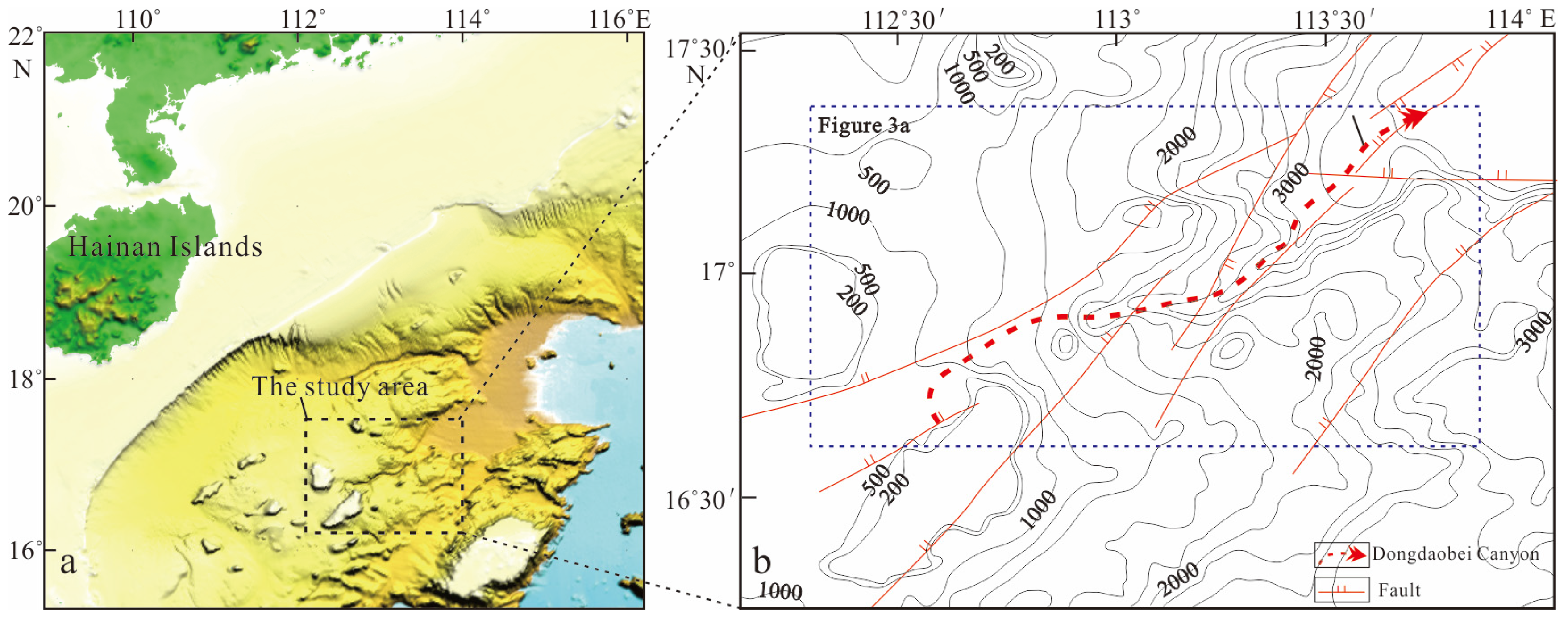
2. Overview of the Study Area
2.1. Geological Background
2.2. Stratigraphic Framework
3. Data and Methods
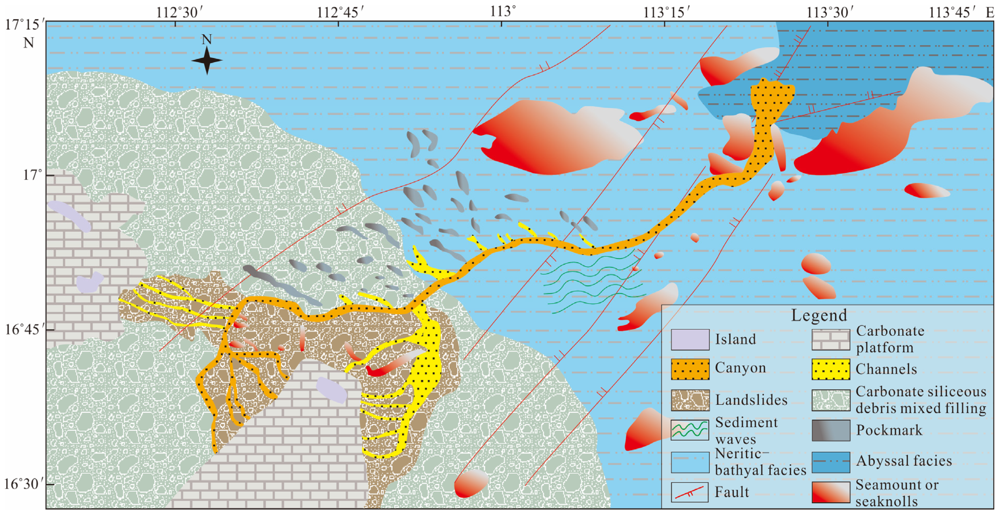
4. Results
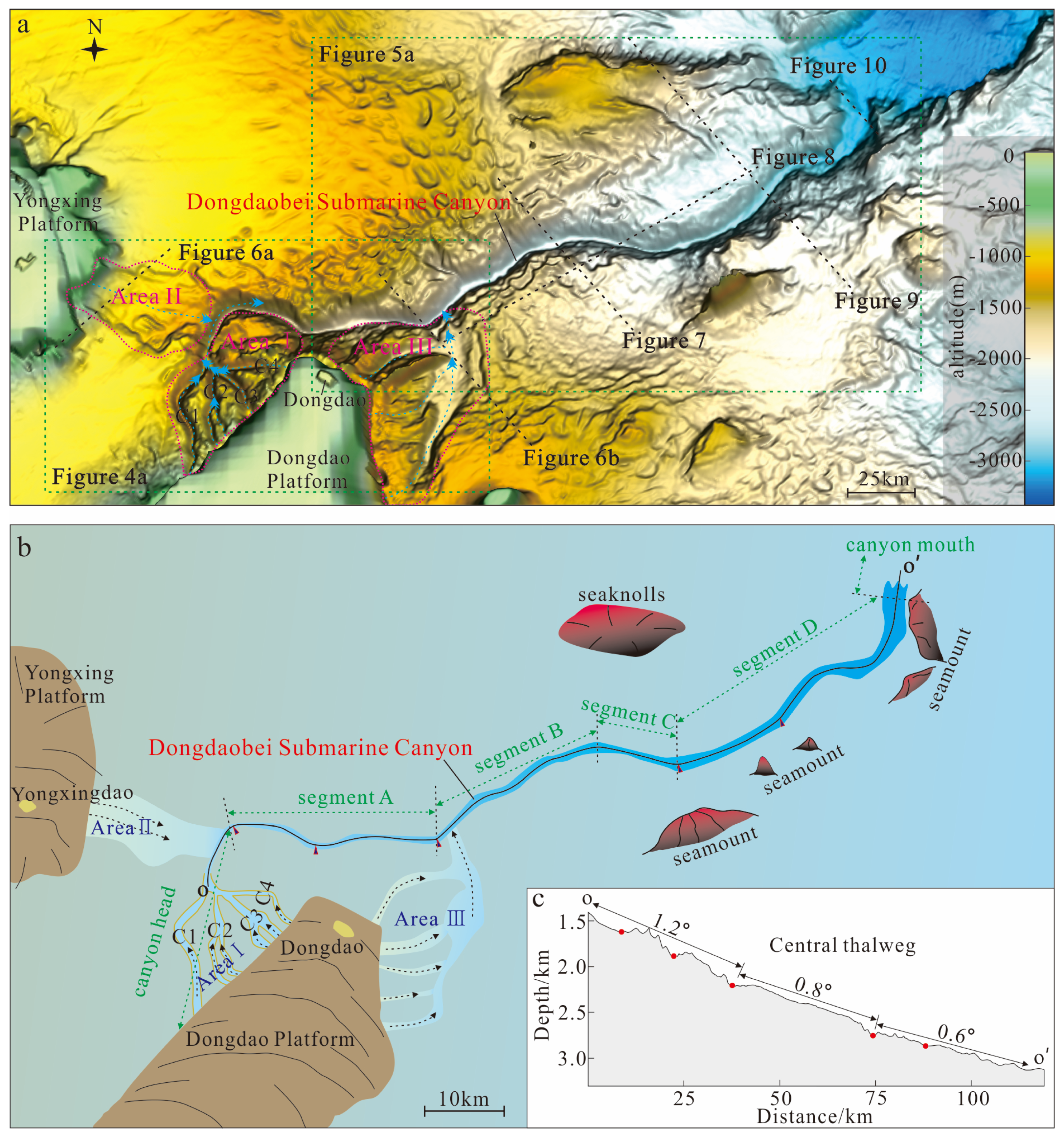
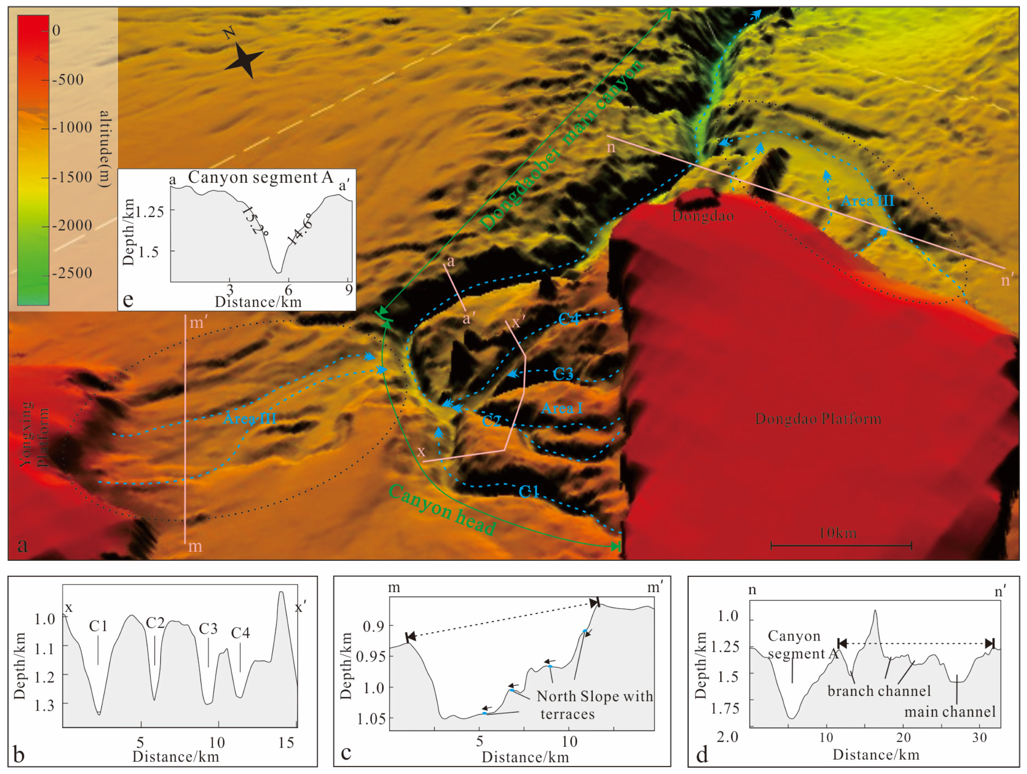
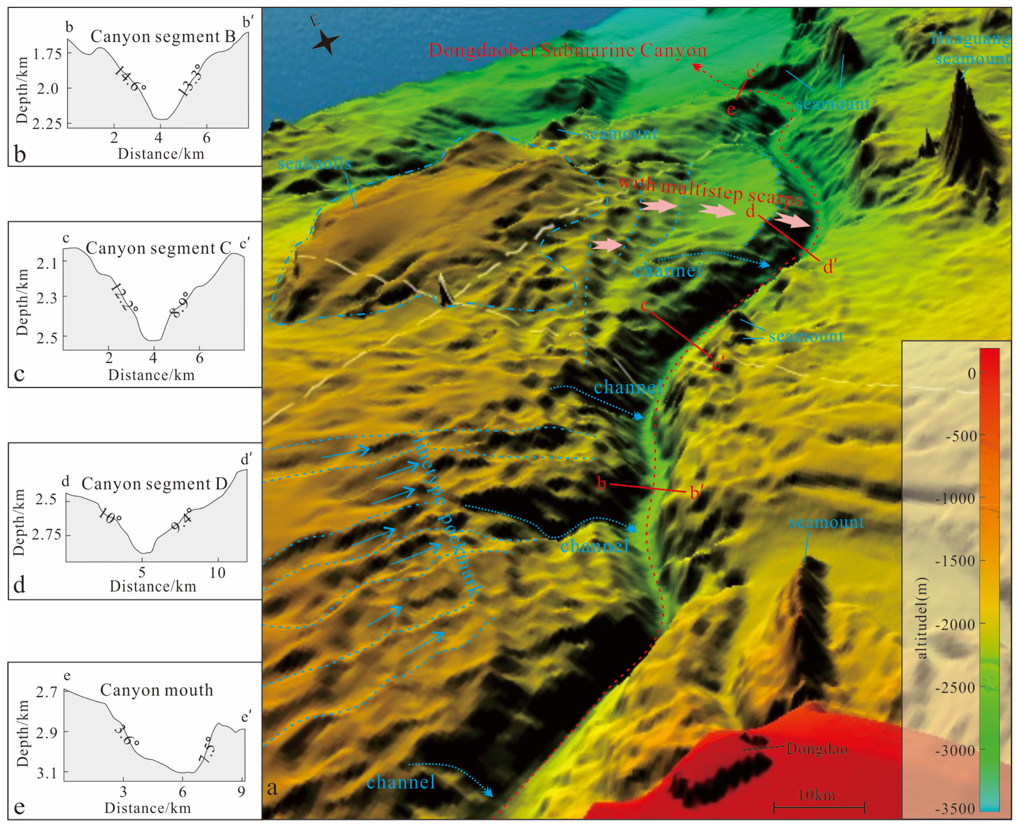
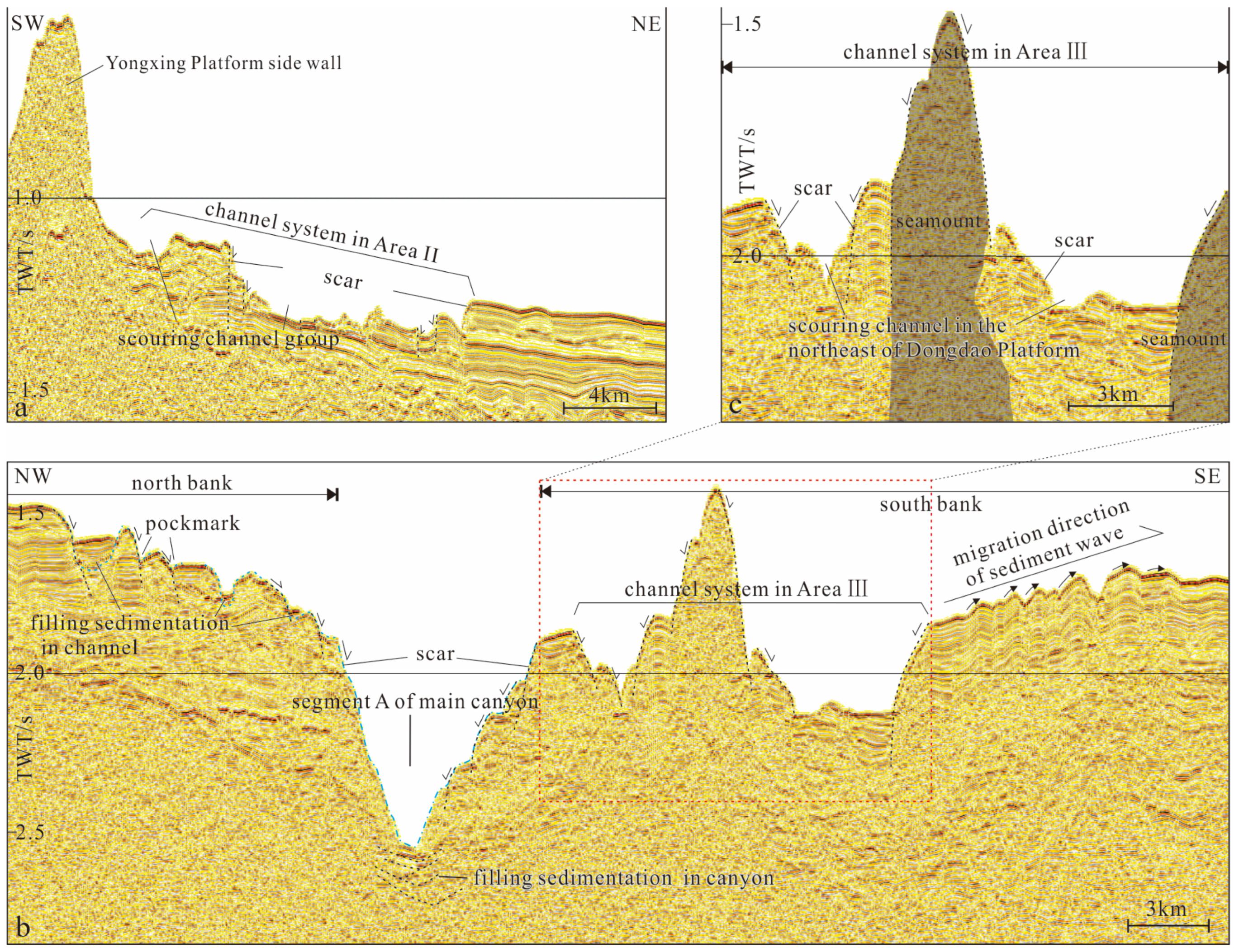
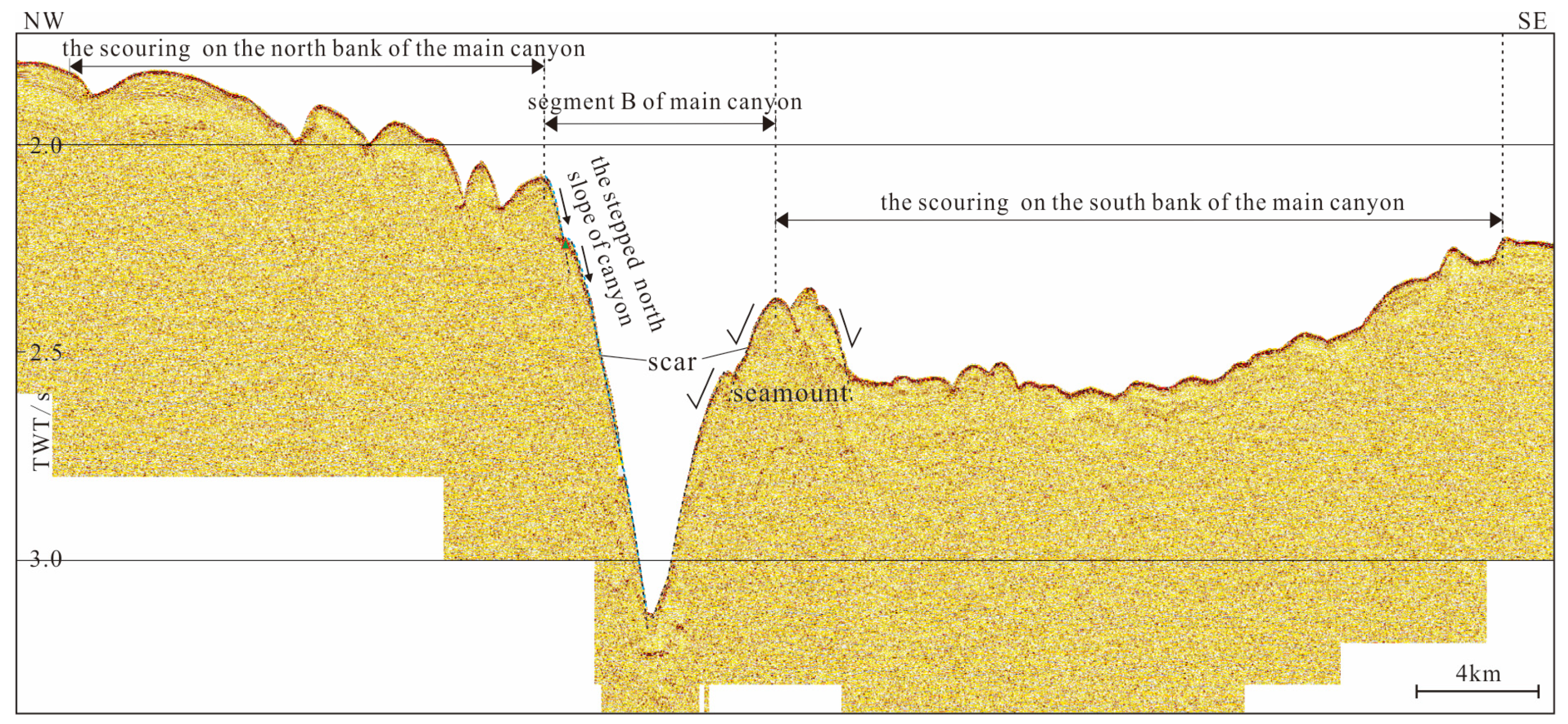
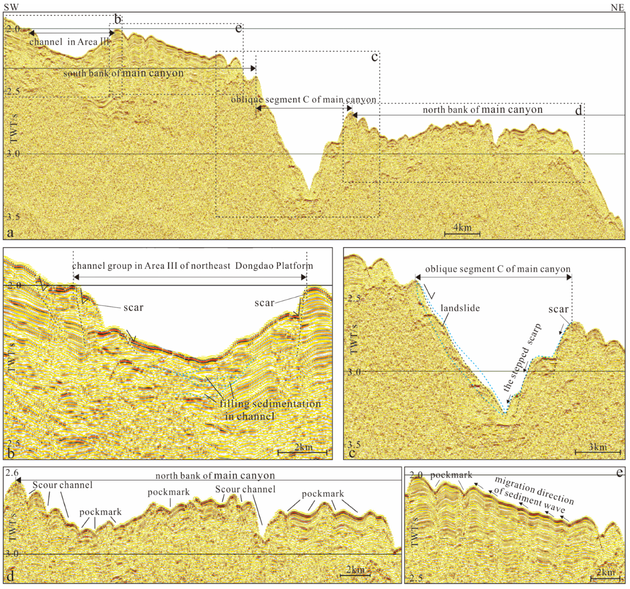
4.1. Morphological Features of Submarine Canyons
4.2. Depositional Architecture of the Canyon
4.2.1. Sediment Provenance Systems
4.2.2. The Sedimentary Filling of the Main Canyon
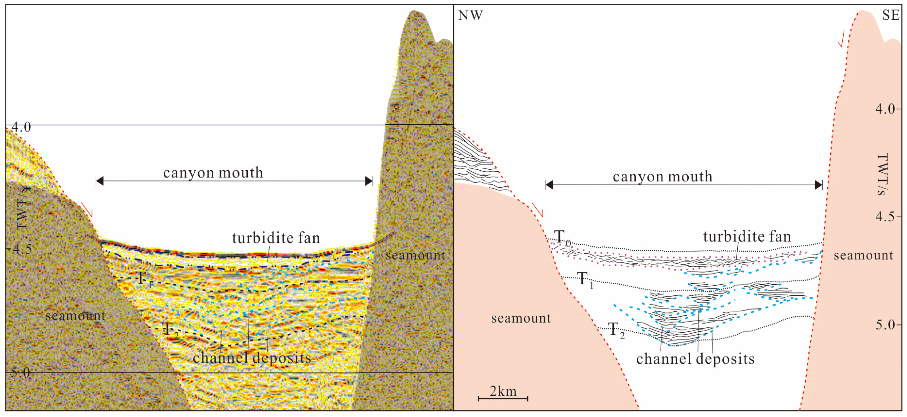
4.2.3. Outside the Canyon Mouth
4.2.4. Canyon Sidewalls
4.3. Tectonic Characteristics
5. Discussion
5.1. The Impact of Erosion and Deposition on Canyon Evolution
5.2. The Impact of Tectonic Factors on Canyon Evolution
5.3. Comparisons with Other Submarine Canyons of Carbonate Platforms and the Sedimentation Model
6. Conclusions
Author Contributions
Funding
Data Availability Statement
Conflicts of Interest
References
- Normark, W.R. Growth patterns of deep-sea fans. AAPG Bull. 1970, 54, 2170–2195. [Google Scholar]
- Popescua, I.; Lericolais, G.; Paninc, N.; Normand, A.; Dinu, C.; Drezen, E.L. The Danube submarine canyon (Black Sea): Morphology and sedimentary processes. Mar. Geol. 2004, 206, 249–265. [Google Scholar] [CrossRef]
- Harris, P.T.; Whiteway, T. Global distribution of large submarine canyons: Geomorphic differences between active and passive continental margins. Mar. Geol. 2011, 285, 69–85. [Google Scholar] [CrossRef]
- Xu, S.; Wang, Y.M.; Peng, X.C.; Zhuo, H.T.; Qiu, Y.; Zhou, W. Depositional Elements and Settings of HD133 and HD77 Cores in the Taiwan Canyon. Acta Sedimentol. Sin. 2013, 31, 325–330. [Google Scholar]
- Su, M.; Zhang, C.; Xie, X.N.; Wang, Z.F.; Jiang, T.; He, Y.L.; Zhang, C.M. Controlling factors on the submarine canyon system: A case study of the Central Canyon System in the Qiongdongnan Basin, northern South China Sea. Sci. China Earth Sci. 2014, 44, 1807–1820. [Google Scholar] [CrossRef]
- Liu, J.; Su, M.; Qiao, S.H.; Sha, Z.B.; Wu, N.Y.; Yang, R. Forming Mechanism of the Slope-confined Submarine Canyons in the Baiyun Sag, Pearl River Mouth Basin. Acta Sedimentol. Sin. 2016, 34, 940–950. [Google Scholar]
- Posamentier, H.W.; Kolla, V. Seismic geomorphology and stratigraphy of depositional elements in deep-water settings. J. Sediment. Res. 2003, 73, 367–388. [Google Scholar] [CrossRef]
- Pyrcz, M.J.; Catuneanu, O.; Deutsch, C.V. Stochastic surface-based modeling of turbidite lobes. AAPG Bull. 2005, 89, 177–191. [Google Scholar] [CrossRef]
- Bernhardt, A.; Jobe, Z.R.; Lowe, D.R. Stratigraphic evolution of a submarine channel-lobe complex system in a narrow fairway within the Magallanes foreland basin, Cerro Toro Formation, southern Chile. Mar. Pet. Geol. 2011, 28, 785–806. [Google Scholar] [CrossRef]
- McDonnell, A.; Loucks, R.G.; Galloway, W.E. Paleocene to Eocene deepwater slope canyons, western Gulf of Mexico: Further insight for the provenance of deep-water offshore Wilcox Group plays. AAPG Bull. 2008, 92, 1169–1189. [Google Scholar] [CrossRef]
- Davies, R.J.; Thatcher, K.E.; Mathias, S.A.; Yang, J. Deepwater canyons: An escape route for methane sealed by methane hydrate. Earth Planet. Sci. Lett. 2012, 323–324, 72–78. [Google Scholar] [CrossRef]
- Chen, H.J.; Cai, G.Q.; Luo, W.D.; Wu, J.Q.; Huang, L.; Li, L.Q. Features of Canyon Morphology and their Origin in the Shenhu area, northern Slope of the South China Sea. Mar. Geol. Quat. Geol. 2012, 32, 19–26. [Google Scholar] [CrossRef]
- Sun, M.J.; Yao, Y.J.; Luo, W.D.; Hu, X.S.; Zhou, J.; Xu, Z.Y.; Ju, D.; Liu, J. Sedimentary Evolution Characteristics and Controlling Factors of Zhongjiannan Canyons in Northwestern South China Sea. Earth Sci. 2022, 47, 4005–4019. [Google Scholar]
- Sun, M.J.; Gao, H.F.; Li, X.J.; Luo, W.D.; Wang, Z.; Liu, J.; Zhao, M.H. Cenozoic sequence stratigraphy and sedimentary evolution of forearc basin in Ryukyu Island Arc region. Acta Petrol. Sin. 2022, 38, 980–992. [Google Scholar]
- Helland-Hansen, W.; Steel, R.J.; Somme, T.O. Shelf genesis revisited. J. Sediment. Res. 2012, 82, 133–148. [Google Scholar] [CrossRef]
- Wang, X.X.; Cai, F.; Sun, Z.L.; Li, Q.; Li, A.; Sun, Y.B.; Wang, H.B.; Sun, Q.L. Tectonic and oceanographic controls on theslope-confined dendritic canyon system in the Dongsha Slope, South China Sea. Geomorphology 2022, 410, 108285. [Google Scholar] [CrossRef]
- Li, X.J.; Wang, D.W.; Wu, S.G.; Wang, W.W.; Liu, G. Geomorphology of Sansha Canyon: I Dentification and Implication. Mar. Geol. Quat. Geol. 2017, 37, 28–36. [Google Scholar]
- Ma, B.J.; Qin, Z.L.; Wu, S.G.; Cai, G.Q.; Li, X.B.; Wang, B.; Liu, X.Q.; Qin, Y.P. High-resolution acoustic data revealing peri-platform sedimentary characteristics in the Xisha Archipelago, South China Sea. Interpretation 2021, 9, 1–44. [Google Scholar] [CrossRef]
- Zhou, J.; Chen, H.J.; Chen, J.L.; Yi, S.T.; Guo, L.H.; Hu, X.S.; Du, W.B.; Sun, M.J. Characteristics and distribution of geohazards since the middle Miocene of the Xisha sea area, South China Sea. Front. Earth Sci. 2023, 10, 1012144. [Google Scholar] [CrossRef]
- Li, Z.X.; Li, X.H. Formation of the 1300-km-Wide Intracontinental Orogen and Postorogenic Magmatic Province in Mesozoic South China: A Flat-Slab Subduction Model. Geology 2007, 35, 179–182. [Google Scholar] [CrossRef]
- Li, C.; Li, J.B.; Ding, W.W.; Franke, D. Seismic stratigraphy of the central South China Sea basin and implications for neotectonics. J. Geophys. Res. 2015, 120, 1377–1399. [Google Scholar] [CrossRef]
- Pubellier, M.; Aurelio, M.; Sautter, B. The Life of a Marginal Basin Depicted in a Structural Map of the South China Sea. Episodes 2018, 41, 139–142. [Google Scholar] [CrossRef]
- Li, X.J.; Wang, Z.; Yao, Y.J.; Gao, H.F.; Zhu, S.; Xu, Z.Y. The formation and evolution of the South China Sea. Geol. Inchina 2020, 47, 1310–1322. [Google Scholar]
- Li, L.; Wang, B.; Lei, C.; Ren, J.Y.; Zhang, Y.Z.; Gao, Y.Y.; Li, L.; Liu, B.W. Tectonic Framework in the Xisha Area and Its Differential Evolution. Earth Sci. 2021, 46, 3321–3337. [Google Scholar]
- Wu, S.G.; Zhu, W.L.; Ma, Y.S. Vicissitude of Cenozoic carbonate platforms in the South China Sea: Sedimentation in semi-closed marginal seas. Mar. Geol. Quat. Geol. 2018, 38, 1–17. [Google Scholar]
- Zhang, G.C. Tectonic evolution of deepwater area of northern continental margin in South China Sea. Acta Pet. Sin. 2010, 31, 528–533+541. [Google Scholar]
- Qiu, X.L.; Ye, S.Y.; Wu, S.M.; Shi, X.B.; Zhou, D.; Xia, K.Y.; Flueh, E.R. Crustal structure across the Xisha Trough, Northwestern South China Sea. Tectonophysics 2001, 341, 179–193. [Google Scholar] [CrossRef]
- Zhu, W.L.; Xie, X.N.; Wang, Z.F.; Zhang, D.J.; Zhang, C.L.; Cao, L.C.; Shao, L. New insights on the origin of the basement of the Xisha uplift, South China Sea. Sci. Sin. 2017, 47, 1460–1468. [Google Scholar] [CrossRef]
- Wu, S.G.; Yang, Z.; Wang, D.W.; Lü, F.L.; Lüdmann, T.; Fulthorpe, C.; Wang, B. Architecture, development and geological control of the Xisha carbonate platforms, northwestern South China Sea. Mar. Geol. 2014, 350, 71–83. [Google Scholar] [CrossRef]
- Pang, X.; Chen, C.M.; Zhu, M.; He, M.; Liu, B.J.; Shen, J.; Lian, S.Y. Frontier of the Deep-water Deposition Study. Geol. Rev. 2007, 53, 145–151. [Google Scholar]
- Qian, X.; Zhang, L.; Wu, S.G.; Yi, H.; Lin, Z.; Yang, Z. Sedimentary Response to Tectonic Evolution of the Northwest Sub-basin, South China Sea. Geotecton. Metallog. 2017, 41, 248–257. [Google Scholar]
- Li, X.L.; Zhang, H.Y.; Liu, G.; Han, X.H.; Qin, Y.P.; Wu, S.G. Seismic sequence and evolution model of isolated carbonate platform—A case from Yongle Atoll, Xisha Islands. Geol. Quat. Geol. 2020, 40, 87–96. [Google Scholar]
- Du, W.B.; Cai, G.Q.; Huang, W.K.; Chen, J.L.; Nie, X.; Wan, X.M. Seismic reflection characteristics of Neogene carbonate platforms in the Xisha Sea Area and their controlling factors. Mar. Geol. Front. 2021, 37, 20–30. [Google Scholar]
- Zhu, W.L.; Wang, Z.F.; Mi, L.J.; Du, X.B.; Xie, X.N.; Lu, Y.C.; Zhang, D.J.; Sun, Z.P.; Liu, X.Y.; You, L. Sequence Stratigraphic Framework and Reef Growth Unit of Well Xike-1 from Xisha Islands, South China Sea. Earth Sci. J. China Univ. Geosci. 2015, 40, 677–687. [Google Scholar]
- Hodgson, D.M.; Peakall, J.; Maier, K.L. Submarine Channel Mouth Settings: Processes, Geomorphology, and Deposits. Front. Earth Sci. 2022, 10, 790320. [Google Scholar] [CrossRef]
- Lin, C.S.; Liu, J.Y.; Cai, S.X.; Zhang, Y.M.; Lv, M.; Li, J. Sedimentary composition and development background of large incised valley and submarine gravity flow system in Yinggehai-Qiongdongnan Basin. Chin. Sci. Bull. 2001, 46, 69–72. [Google Scholar] [CrossRef]
- Hovland, M.; Gardner, J.V.; Judd, A.G. The significance of pockmarks to understanding fluid flow processes and geohazards. Geofluids 2002, 2, 127–136. [Google Scholar] [CrossRef]
- Huang, Y.; Cheng, J.; Wang, M.; Wang, S.; Yan, W. Gas Hydrate Dissociation Events During LGM and Their Potential Trigger of Submarine Landslides: Foraminifera and Geochemical Records from TwoCores in the Northern South China Sea. Front. Earth Sci. 2022, 10, 876913. [Google Scholar] [CrossRef]
- Spatola, D.; Micallef, A.; Sulli, A.; Basilone, L.; Ferreri, R.; Basilone, G.; Bonanno, A.; Pulizzi, M.; Mangano, S. The Graham Bank (Sicily Channel, central Mediterranean Sea): Seafloor signatures of volcanic and tectonic controls. Geomorphology 2018, 318, 375–389. [Google Scholar] [CrossRef]
- Ma, Y.; Wu, S.G.; Lv, F.L.; Dong, D.D.; Sun, Q.L.; Lu, Y.T.; Gu, M.F. Seismic characteristics and development of the Xisha carbonate platforms, northern margin of the South China Sea. J. Asian Earth Sci. 2011, 40, 770–783. [Google Scholar]
- Feng, Y.C.; Zhan, W.H.; Sun, J.; Yao, Y.T.; Guo, L.; Chen, M. The formation mechanism and characteristics of volcanoes in the Xisha waters since Pliocene. J. Trop. Oceanogr. 2017, 36, 73–79. [Google Scholar]
- Zhong, G.J.; Feng, C.M.; Wei, Z.Q. The Structural Features of Xisha Trough Basin. Mar. Geol. Quat. Geol. 2012, 32, 63–68. [Google Scholar] [CrossRef]
- Briais, A.; Patriat, P.; Tapponnier, P. Updated Interpretation of Magnetic Anomalies and Seafloor Spreading Stages in the South China Sea: Implications for the Tertiary Tectonics of Southeast Asia. J. Geo Phys. Res. Solid. Earth 1993, 98, 6299–6328. [Google Scholar] [CrossRef]
- Payros, A.; Pujalte, V. Calciclastic submarine fans: An integrated overview. Earth-Sci. Rev. 2008, 86, 203–246. [Google Scholar] [CrossRef]
- Chen, J.J.; Wu, S.G.; Li, Q.; Wei, C.L.; Fu, G.W.; Chen, W.L.; Qin, Y.P.; Khan, U.; Wu, S.L. Morphology and evolution of submarine canyons around the Zhongsha Platform, South China Sea: Implications for sedimentary processes in a modern isolated carbonate setting. Mar. Geol. 2024, 475, 107362. [Google Scholar] [CrossRef]
- Li, S.; Alves, T.M.; Li, W.; Wang, X.J.; Rebesco, M.; Li, J.; Zhao, F.; Yu, K.Q.; Wu, S.G. Morphology and evolution of submarine canyons on the north west South China Seamargin. Mar. Geol. 2022, 443, 106695. [Google Scholar] [CrossRef]


| Canyon Segment | Strike | Water Depth (m) | Incised Valley Shape | Down Cutting Depth (m) | Top Section Width (m) | Breadth Depth Ratio | Recognizable Filling Thickness (m) | |
|---|---|---|---|---|---|---|---|---|
| Canyon head | C1 | N-NNW-NS | 1187 | V-shaped | 236 | 2109 | 8.9 | Unable to identify due to data limitations |
| C2 | NS | 1239 | 263 | 2632 | 10 | |||
| C3 | N-NW | 1262 | 286 | 2458 | 8.6 | |||
| C4 | N-NWW | 1211 | 272 | 2664 | 9.8 | |||
| Canyon trunk | A | E | 1574~2200 | V-shaped | min 424 | 4879 | 11.5 | |
| max 544 | 4478 | 8.2 | ||||||
| B | NE | 2200~2399 | min 453 | 3812 | 8.4 | |||
| max 646 | 7879 | 12.2 | ||||||
| C | E | 2399~2704 | min 367 | 7420 | 20.2 | |||
| max 530 | 6400 | 12 | ||||||
| D | NE-N | 2704~3102 | U-shaped | min 170 | 5071 | 29.8 | 45 | |
| max 396 | 7533 | 19 | ||||||
Disclaimer/Publisher’s Note: The statements, opinions and data contained in all publications are solely those of the individual author(s) and contributor(s) and not of MDPI and/or the editor(s). MDPI and/or the editor(s) disclaim responsibility for any injury to people or property resulting from any ideas, methods, instructions or products referred to in the content. |
© 2025 by the authors. Licensee MDPI, Basel, Switzerland. This article is an open access article distributed under the terms and conditions of the Creative Commons Attribution (CC BY) license (https://creativecommons.org/licenses/by/4.0/).
Share and Cite
Sun, M.; Chen, H.; Yang, C.; Hu, X.; Liu, J. Multifactorial Controls on the Dongdaobei Submarine Canyon System, Xisha Sea, South China Sea. J. Mar. Sci. Eng. 2025, 13, 564. https://doi.org/10.3390/jmse13030564
Sun M, Chen H, Yang C, Hu X, Liu J. Multifactorial Controls on the Dongdaobei Submarine Canyon System, Xisha Sea, South China Sea. Journal of Marine Science and Engineering. 2025; 13(3):564. https://doi.org/10.3390/jmse13030564
Chicago/Turabian StyleSun, Meijing, Hongjun Chen, Chupeng Yang, Xiaosan Hu, and Jie Liu. 2025. "Multifactorial Controls on the Dongdaobei Submarine Canyon System, Xisha Sea, South China Sea" Journal of Marine Science and Engineering 13, no. 3: 564. https://doi.org/10.3390/jmse13030564
APA StyleSun, M., Chen, H., Yang, C., Hu, X., & Liu, J. (2025). Multifactorial Controls on the Dongdaobei Submarine Canyon System, Xisha Sea, South China Sea. Journal of Marine Science and Engineering, 13(3), 564. https://doi.org/10.3390/jmse13030564