
Joining Application of Unmanned Aerial Vehicle Imagery with GIS for Monitoring of Soft Cliff Linear Habitats

 ,
,  , , and
Abstract
1. Introduction
- Shape: Linear littoral habitats are narrow habitats characterized by a vast longitudinal range compared to a relatively thin width.
- Structure: Linear littoral habitats are relatively homogenous. It contrasts with areal littoral habitats, which are typically patchy.
- Distinctive gradients: The boundaries of linear littoral habitats are defined by steep and distinctive hydro- and litho-dynamic, salinity, and ecological gradients, which feature the complexity of these ecosystems.
2. Materials and Methods
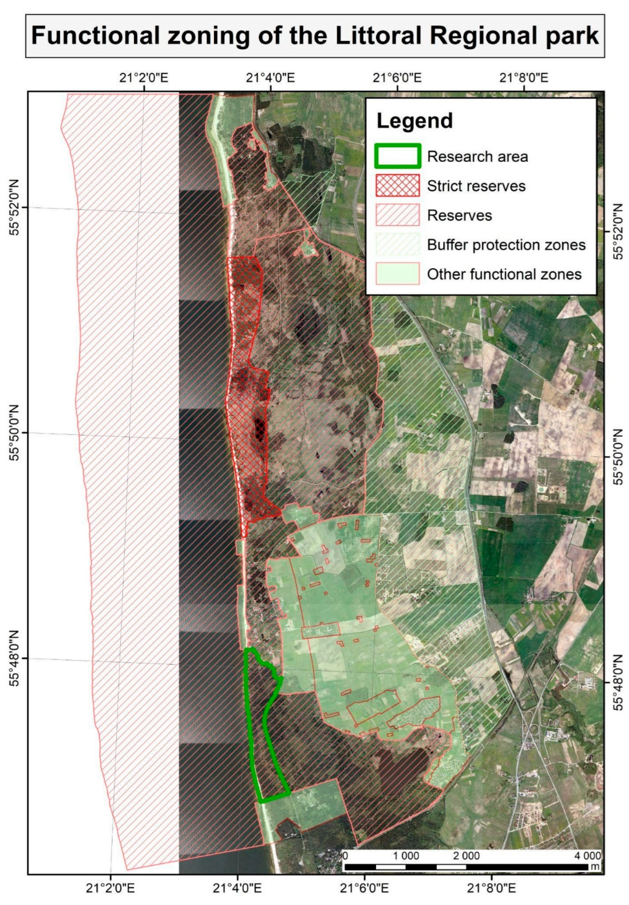
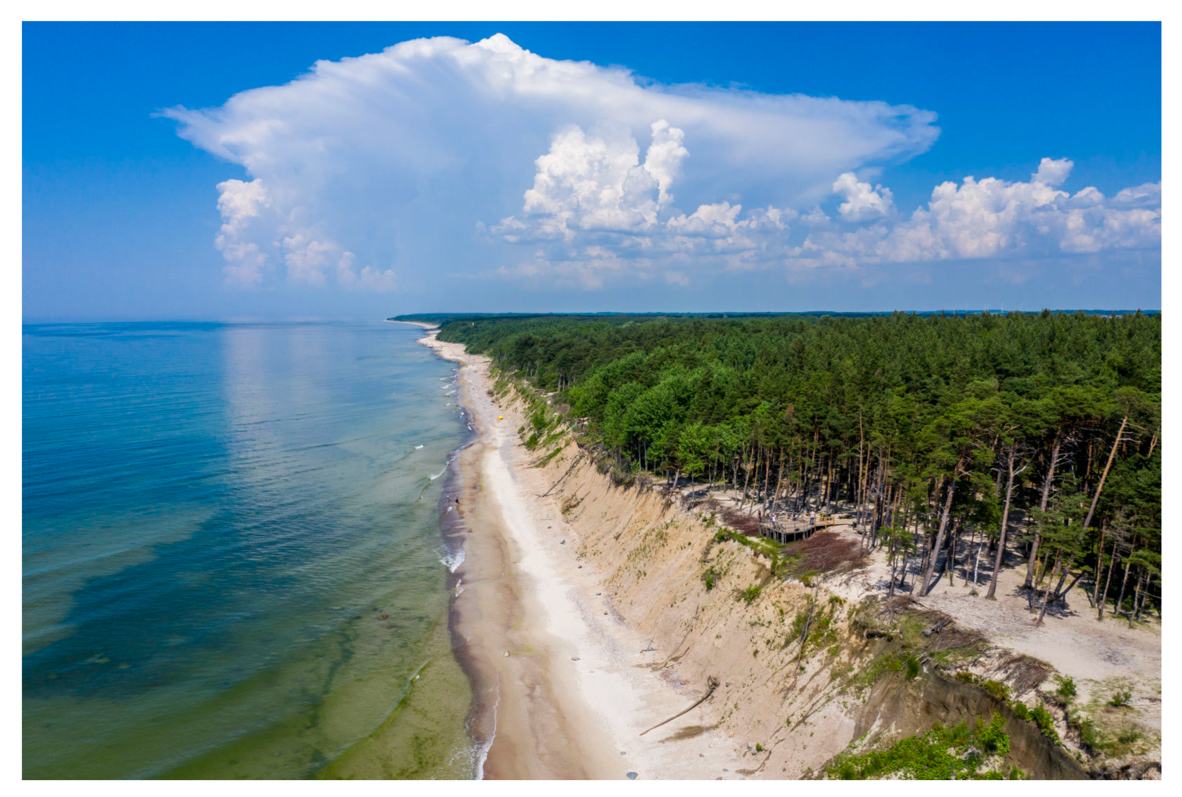
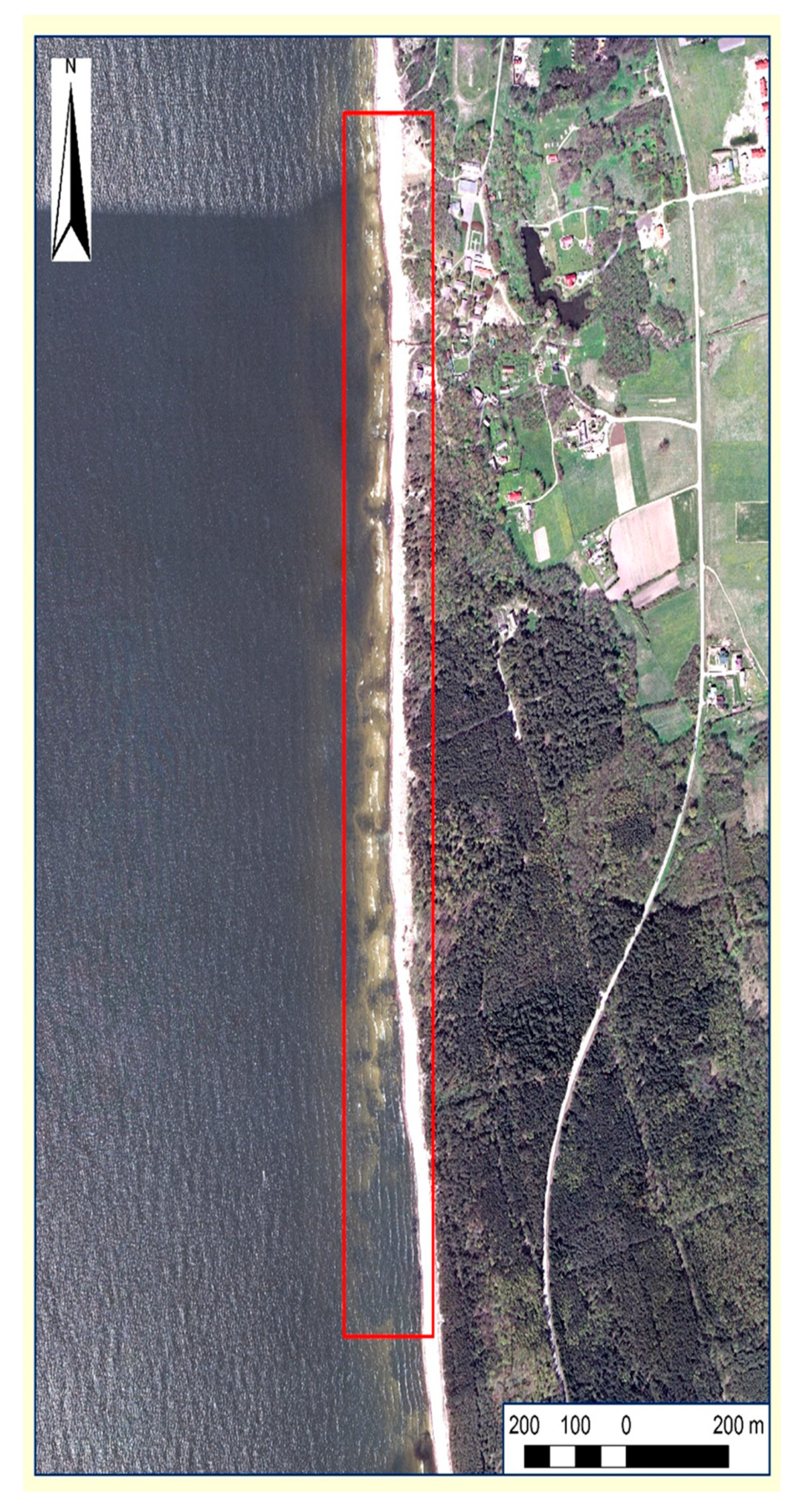
2.1. Study Area
- Southeast Scandinavian coast and islands;
- South Baltic coast and islands;
- Southeast Baltic graded coast.
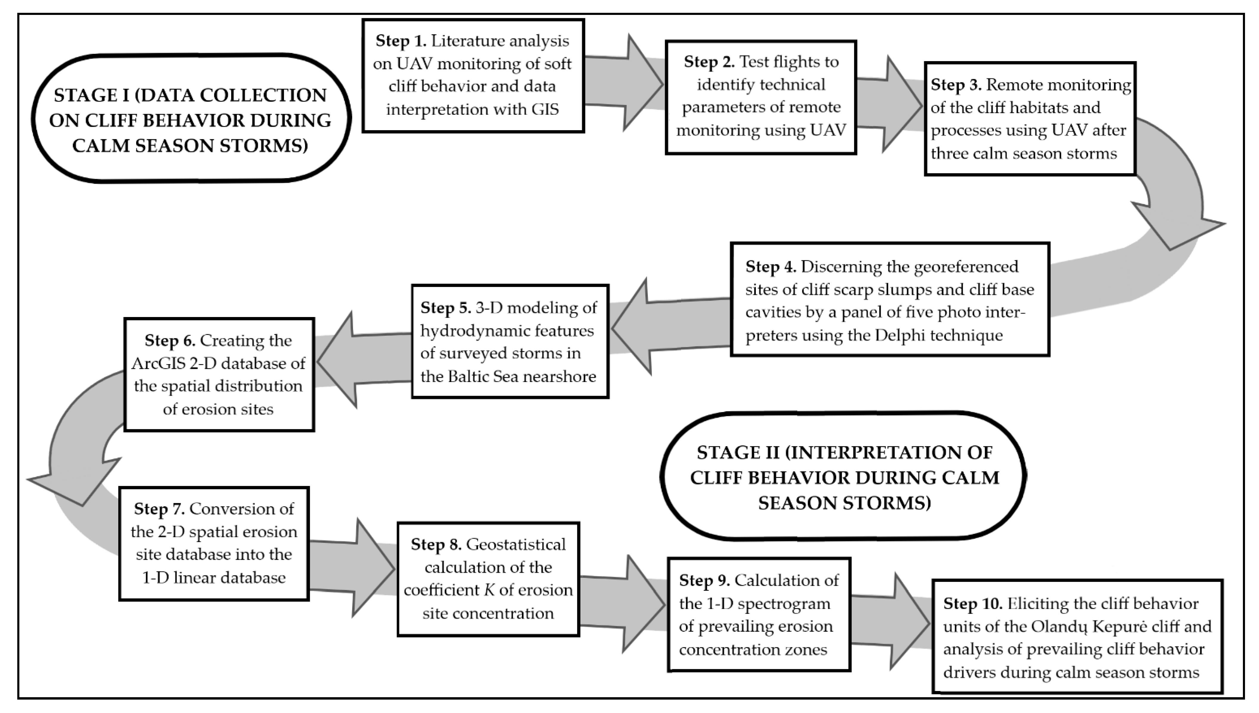
2.2. Research Overview
2.3. Monitoring Using UAV
2.4. Delphi Technique
2.5. Nearshore Wave Height, Surge Level and Longshore Current Modelling
2.6. Application of GIS
3. Results
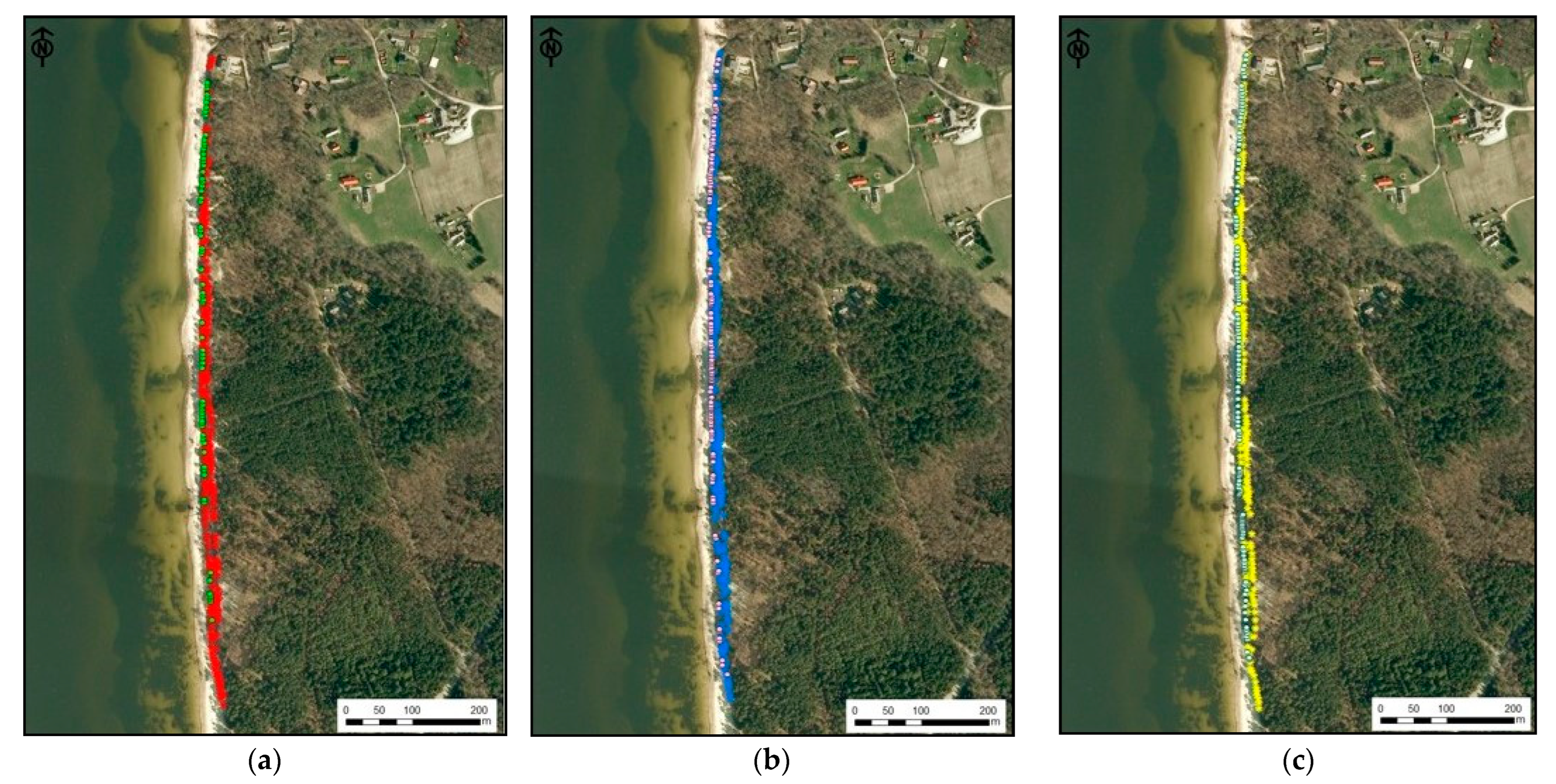
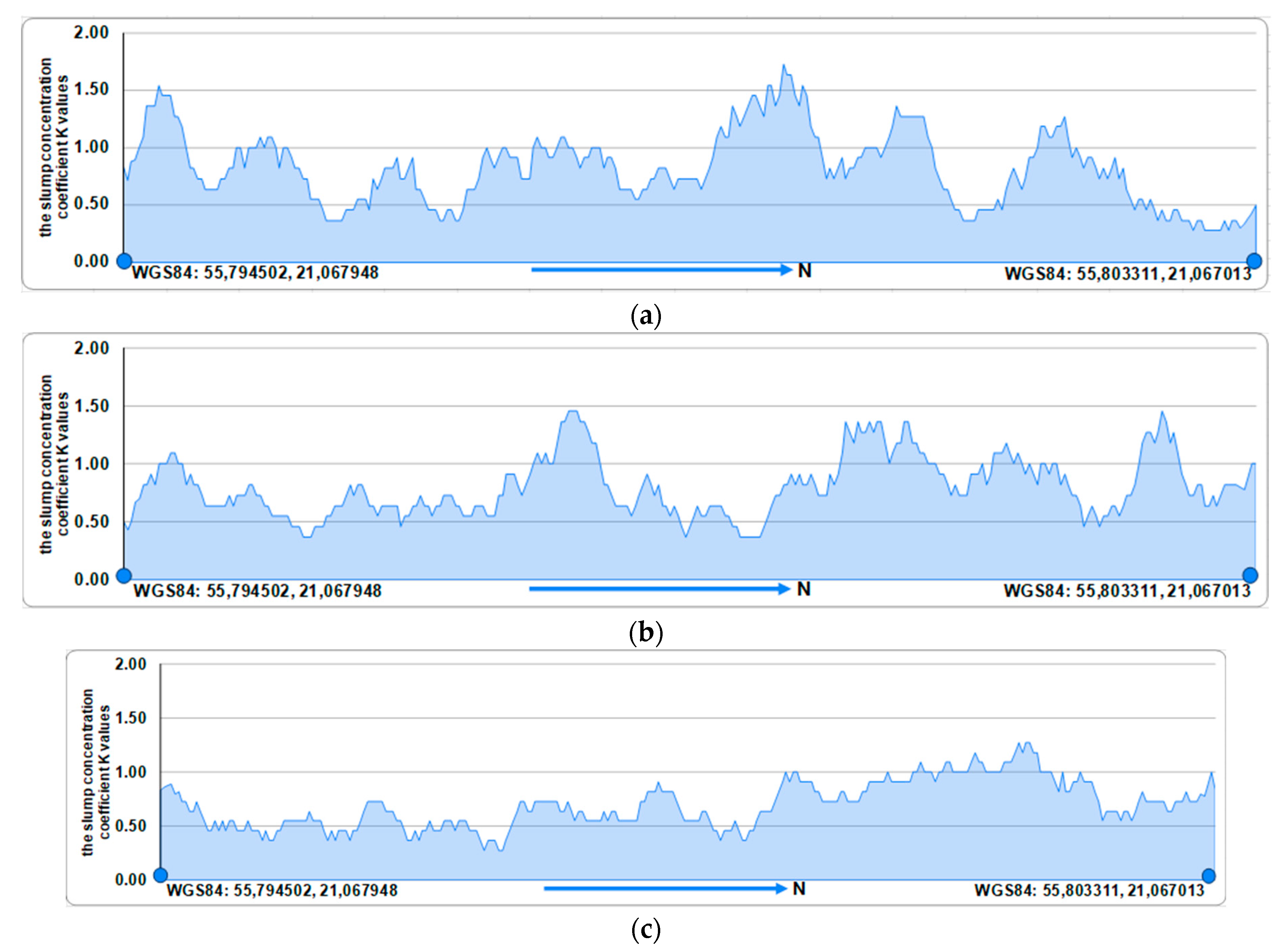
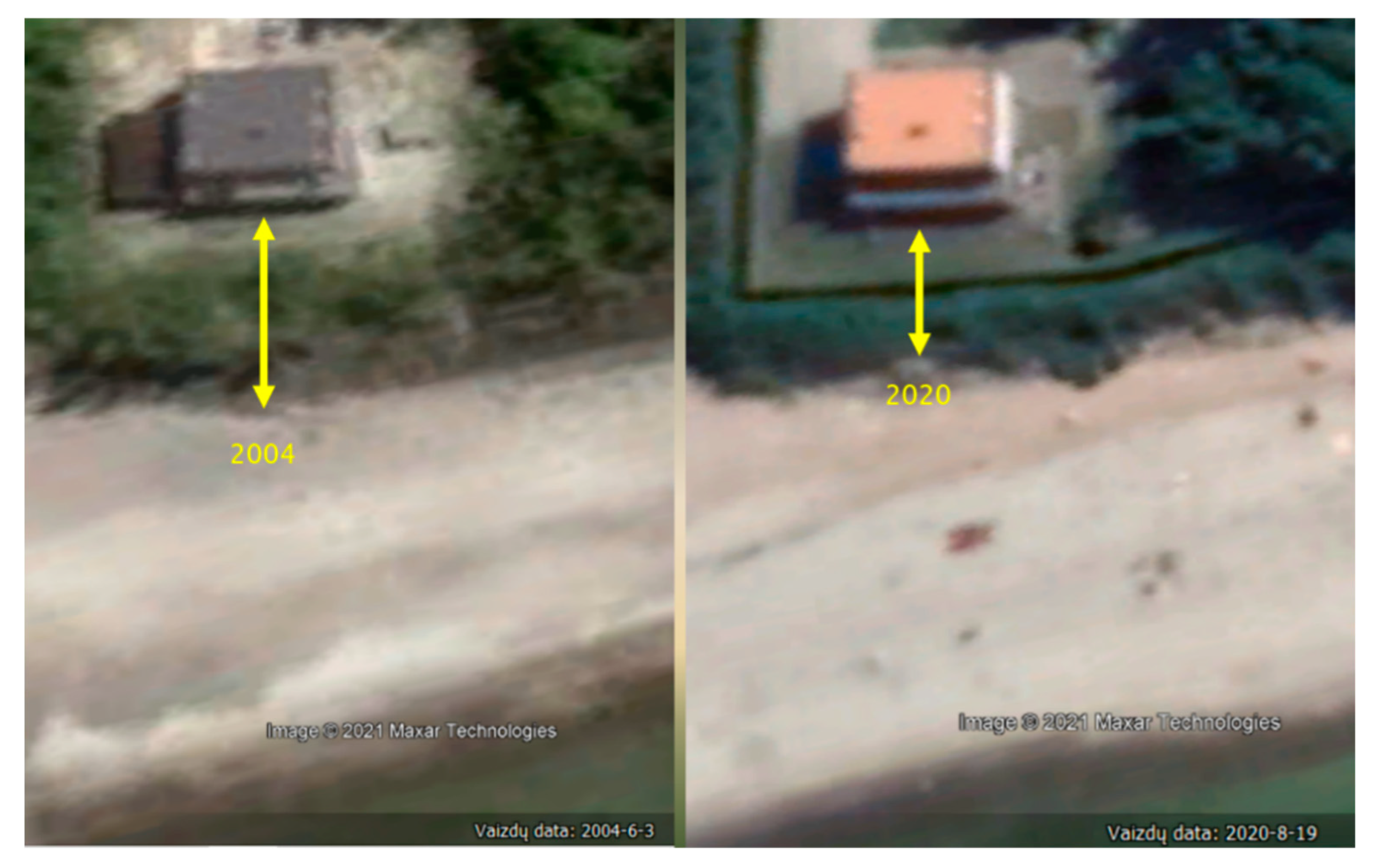
3.1. Spatial Behavior Patterns of the Olandų Kepurė Cliff
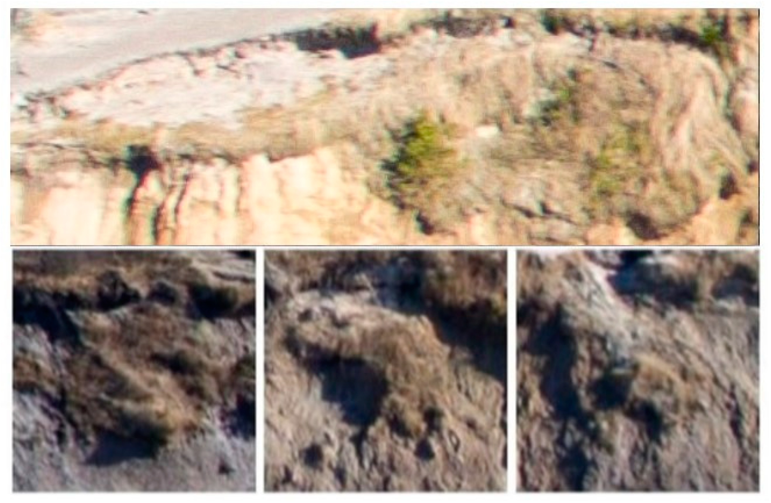
3.2. Spatial Patterns of the Cliff Scarp Slump Distribution
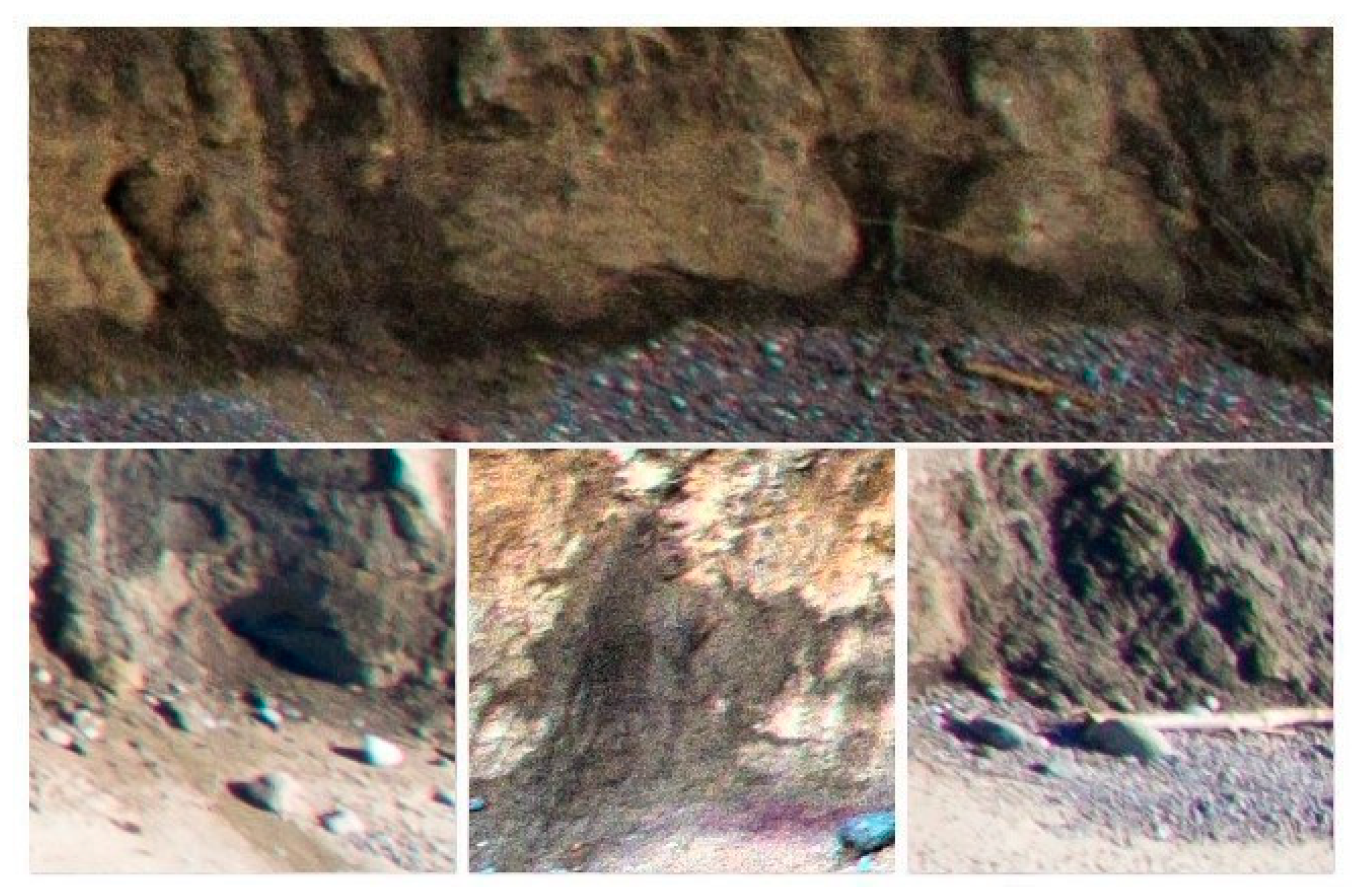
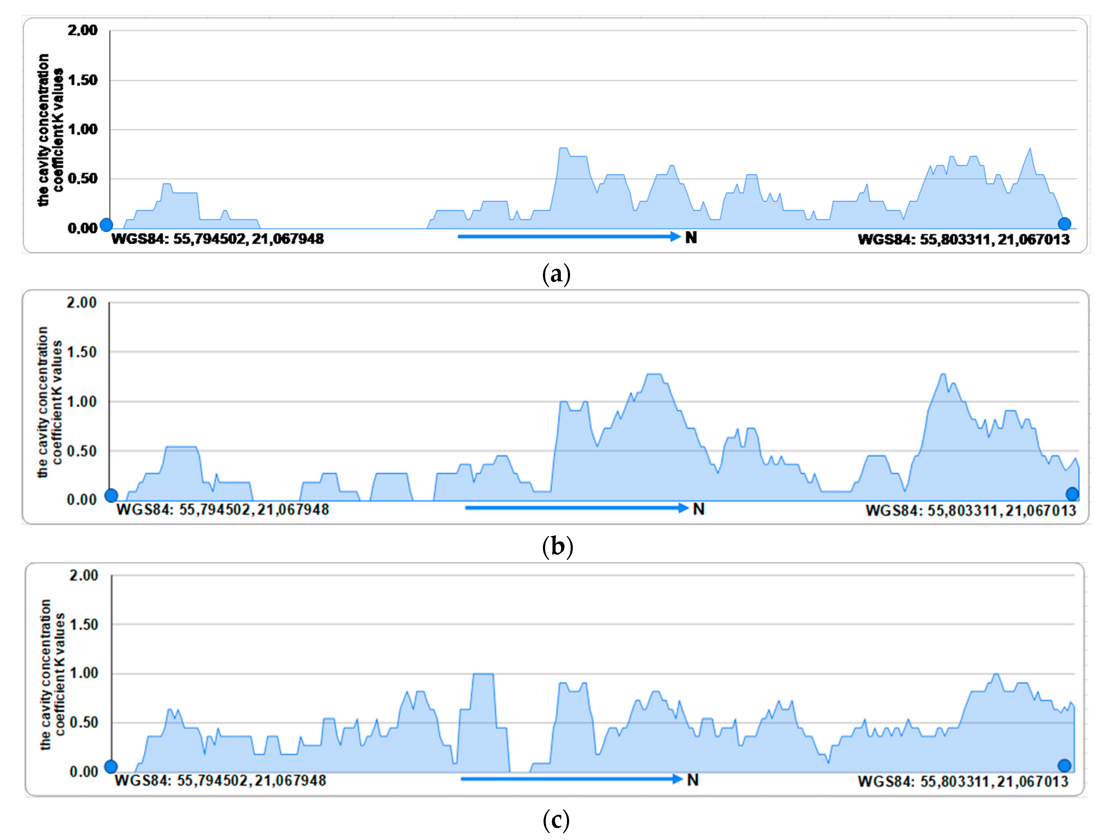
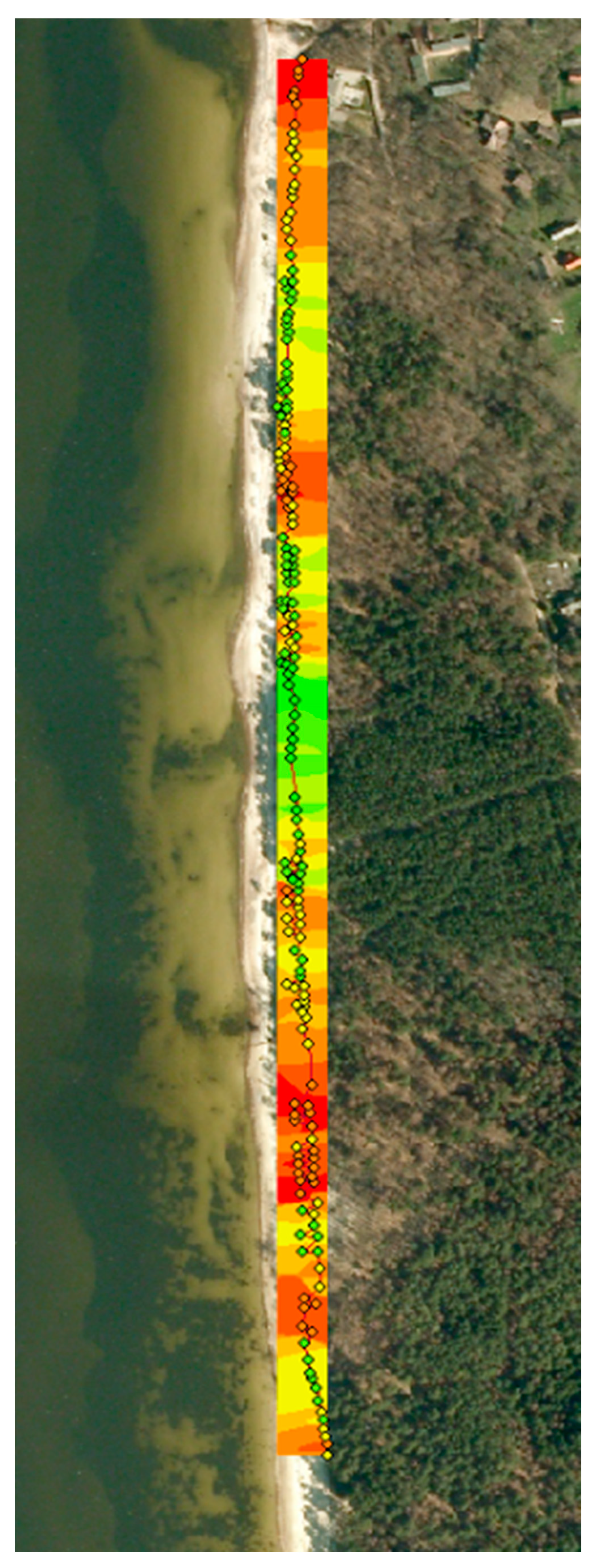
3.3. Spatial Distribution Patterns of the Cliff Base Cavities
3.4. Nearshore Hydrodynamics at the Olandų Kepurė Cliff
3.5. Cliff Cells and Behavior Units of the Olandų Kepurė Cliff
4. Discussion
- Wave action, including hydraulic action and abrasion, and fluid shearing by up-rushing waves during large storms;
- Seepage erosion;
- Surface erosion, i.e., run-off and wind erosion;
- Gravitational mass movement (creep).
5. Conclusions
Author Contributions
Funding
Institutional Review Board Statement
Informed Consent Statement
Data Availability Statement
Acknowledgments
Conflicts of Interest
References
- Robles-Diaz-de-León, L.F.; Nava-Tudela, A. Playing with Asimina triloba (pawpaw): A species to consider when enhancing riparian forest buffer systems with non-timber products. Ecol. Model. 1998, 112, 169–193. [Google Scholar] [CrossRef]
- Povilanskas, R.; Armaitienė, A.; Breber, P.; Razinkovas-Baziukas, A.; Taminskas, J. The Integrity of Linear Littoral Habitats of Lesina and Curonian Lagoons. Hydrobiologia 2012, 699, 99–110. [Google Scholar] [CrossRef]
- Povilanskas, R.; Chubarenko, B.V. Interaction between the drifting dunes of the Curonian Barrier Spit and the Curonian Lagoon. Baltica 2000, 13, 8–14. [Google Scholar]
- Povilanskas, R.; Riepšas, E.; Armaitienė, A.; Dučinskas, K.; Taminskas, J. Shifting Dune Types of the Curonian Spit and Factors of Their Development. Balt. For. 2011, 17, 215–226. [Google Scholar]
- Povilanskas, R. Landscape Management on the Curonian Spit: A Cross-Border Perspective; EUCC Publishers: Klaipeda, Lithuania, 2004; 242p. [Google Scholar]
- Šimanauskienė, R.; Linkevičienė, R.; Povilanskas, R.; Satkūnas, J.; Veteikis, D.; Baubinienė, A.; Taminskas, J. Curonian Spit coastal dunes landscape: Climate driven change calls for the management optimization. Land 2022, 11, 877. [Google Scholar] [CrossRef]
- Zhu, E.; Gao, H.; Chen, L.; Yao, J.; Liu, T.; Sha, M. Interactions between coastal protection forest ecosystems and human activities: Quality, service and resilience. Ocean Coast. Manag. 2024, 254, 107190. [Google Scholar] [CrossRef]
- Danial, H.; Syahrul, S.S.; Muhammad, Y. A Model of Fish Marketing at Paotere Fishing Ports for Increasing Fishermen’s Income. Int. J. Dev. Res. 2018, 8, 20013–20018. [Google Scholar]
- Doody, J.P. Sand Dune Conservation, Management and Restoration; Springer: Dordrecht, The Netherlands, 2013; 304p. [Google Scholar]
- Pontee, N. Defining coastal squeeze: A discussion. Ocean Coast. Manag. 2013, 84, 204–207. [Google Scholar] [CrossRef]
- Doody, J.P. ‘Coastal squeeze’—An historical perspective. J. Coast. Conserv. 2004, 10, 129–138. [Google Scholar] [CrossRef]
- Silva, R.; Martínez, M.L.; van Tussenbroek, B.I.; Guzmán-Rodríguez, L.O.; Mendoza, E.; López-Portillo, J. A framework to manage coastal squeeze. Sustainability 2020, 12, 10610. [Google Scholar] [CrossRef]
- Jordan, P.; Fröhle, P. Bridging the gap between coastal engineering and nature conservation? A review of coastal ecosystems as nature-based solutions for coastal protection. J. Coast. Conserv. 2022, 26, 4. [Google Scholar] [CrossRef]
- Pörtner, H.O.; Roberts, D.C.; Masson-Delmotte, V. The Ocean and Cryosphere in a Changing Climate: Special Report of the Intergovernmental Panel on Climate Change; Cambridge University Press: Cambridge, UK, 2022; 756p. [Google Scholar]
- Luijendijk, A.; Hagenaars, G.; Ranasinghe, R.; Baart, F.; Donchyts, G.; Aarninkhof, S. The state of the world’s beaches. Sci. Rep. 2018, 8, 6641. [Google Scholar] [CrossRef] [PubMed]
- Er-Ramy, N.; Nachite, D.; Anfuso, G.; Williams, A.T. Coastal scenic quality assessment of Moroccan Mediterranean beaches: A tool for proper management. Water 2022, 14, 1837. [Google Scholar] [CrossRef]
- Yasmeen, A.; Pumijumnong, N.; Arungrat, N.; Punwong, P.; Sereenonchai, S.; Chareonwong, U. Nature-based solutions for coastal erosion protection in a changing climate: A cutting-edge analysis of contexts and prospects of the muddy coasts. Estuar. Coast. Shelf Sci. 2024, 298, 108632. [Google Scholar] [CrossRef]
- Jurkus, E.; Povilanskas, R.; Taminskas, J. Current Trends and Issues in Research on Biodiversity Conservation and Tourism Sustainability. Sustainability 2022, 14, 3342. [Google Scholar] [CrossRef]
- Jurkus, E.; Povilanskas, R.; Razinkovas-Baziukas, A.; Taminskas, J. Current trends and issues in applications of remote sensing for coastal and marine nature conservation. Earth 2022, 3, 433–447. [Google Scholar] [CrossRef]
- Chen, H. The ecosystem service value of maintaining and expanding terrestrial protected areas in China. Sci. Total Environ. 2021, 781, 146768. [Google Scholar] [CrossRef] [PubMed]
- Fennell, D.A. Ecotourism, 5th ed.; Routledge: Oxon, UK; New York, NY, USA, 2020; xviii + 282p. [Google Scholar]
- Schirpke, U.; Meisch, C.; Tappeiner, U. Symbolic species as a cultural ecosystem service in the European Alps: Insights and open issues. Landsc. Ecol. 2018, 33, 711–730. [Google Scholar] [CrossRef]
- Chun, J.; Kim, C.K.; Kim, G.S.; Jeong, J.; Lee, W.K. Social big data informs spatially explicit management options for national parks with high tourism pressures. Tour. Manag. 2020, 81, 104136. [Google Scholar] [CrossRef]
- Dalton, D.T.; Pascher, K.; Berger, V.; Steinbauer, K.; Jungmeier, M. Novel Technologies and Their Application for Protected Area Management: A Supporting Approach in Biodiversity Monitoring. In Protected Area Management-Recent Advances; Nazip Suratman, M., Ed.; IntechOpen: London, UK, 2021; Available online: https://www.intechopen.com/chapters/78656 (accessed on 1 February 2022).
- Smith, M.K.S.; Smit, I.P.; Swemmer, L.K.; Mokhatla, M.M.; Freitag, S.; Roux, D.J.; Dziba, L. Sustainability of protected areas: Vulnerabilities and opportunities as revealed by COVID-19 in a national park management agency. Biol. Conserv. 2021, 255, 108985. [Google Scholar] [CrossRef]
- Cheung, S.Y.; Leung, Y.F.; Larson, L.R. Citizen science as a tool for enhancing recreation research in protected areas: Applications and opportunities. J. Environ. Manag. 2022, 305, 114353. [Google Scholar] [CrossRef] [PubMed]
- Ferreira, C.C.; Stephenson, P.J.; Gill, M.; Regan, E.C. Biodiversity Monitoring and the Role of Scientists in the Twenty-first Century. In Closing the Knowledge-Implementation Gap in Conservation Science; Ferreira, C.C., Klütsch, C.F.C., Eds.; Springer: Cham, Switzerland, 2021; pp. 25–50. [Google Scholar]
- Suškevičs, M.; Raadom, T.; Vanem, B.; Kana, S.; Roasto, R.; Runnel, V.; Külvik, M. Challenges and opportunities of engaging biodiversity-related citizen science data in environmental decision-making: Practitioners’ perceptions and a database analysis from Estonia. J. Nat. Conserv. 2021, 64, 126068. [Google Scholar] [CrossRef]
- Heberling, J.M.; Miller, J.T.; Noesgaard, D.; Weingart, S.B.; Schigel, D. Data integration enables global biodiversity synthesis. Proc. Natl. Acad. Sci. USA 2021, 118, e2018093118. [Google Scholar] [CrossRef]
- Jessen, T.D.; Ban, N.C.; Claxton, N.X.; Darimont, C.T. Contributions of Indigenous Knowledge to ecological and evolutionary understanding. Front. Ecol. Environ. 2022, 20, 93–101. [Google Scholar] [CrossRef]
- Mi, X.; Feng, G.; Hu, Y.; Zhang, J.; Chen, L.; Corlett, R.T.; Hughes, A.C.; Pimm, S.; Schmid, B.; Shi, S.; et al. The global significance of biodiversity science in China: An overview. Nat. Sci. Rev. 2021, 8, nwab032. [Google Scholar] [CrossRef] [PubMed]
- Gardel, A.; Anthony, E.J.; Santos, V.F.; Huybrechts, N.; Lesourd, S.; Sottolichio, A.; Maury, T. A remote sensing-based classification approach for river mouths of the Amazon-influenced Guianas coast. Region. Environ. Change 2022, 22, 65. [Google Scholar] [CrossRef]
- Moniruzzaman, M.; Islam, S.M.; Lavery, P.; Bennamoun, M.; Lam, C.P. Imaging and classification techniques for seagrass mapping and monitoring: A comprehensive survey. arXiv 2019, arXiv:1902.11114. [Google Scholar]
- Orusa, T.; Borgogno Mondino, E. Exploring Short-term climate change effects on rangelands and broad-leaved forests by free satellite data in Aosta Valley (Northwest Italy). Climate 2021, 9, 47. [Google Scholar] [CrossRef]
- da Silveira, C.B.L.; Strenzel, G.M.R.; Maida, M.; Gaspar, A.L.B.; Ferreira, B.P. Coral Reef Mapping with Remote Sensing and Machine Learning: A Nurture and Nature Analysis in Marine Protected Areas. Remote Sens. 2021, 13, 2907. [Google Scholar] [CrossRef]
- Failler, P.; Touron-Gardic, G.; Sadio, O.; Traoré, M.S. Perception of natural habitat changes of West African marine protected areas. Ocean Coast. Manag. 2020, 187, 105120. [Google Scholar] [CrossRef]
- Singh, A.A.; Maharaj, A.; Singh, P. Benthic Resource Baseline Mapping of Cakaunisasi and Yarawa Reef Ecosystem in the Ba Region of Fiji. Water 2021, 13, 468. [Google Scholar] [CrossRef]
- Costello, M.J.; Darnaedi, D.; Diway, B.; Ganyai, T.; Grudpan, C.; Hughes, A.; Ishii, R.; Lim, P.T.; Ma, K.; Muslim, A.M.; et al. The Asia-Pacific Biodiversity Observation Network: 10-year achievements and new strategies to 2030. Ecol. Res. 2021, 36, 232–257. [Google Scholar]
- Visalli, M.E.; Best, B.D.; Cabral, R.B.; Cheung, W.W.L.; Clark, N.A.; Garilao, C.; Kaschner, K.; Kesner-Reyes, K.; Lam, V.W.Y.; Maxwell, S.M.; et al. Data-driven approach for highlighting priority areas for protection in marine areas beyond national jurisdiction. Mar. Policy 2020, 122, 103927. [Google Scholar] [CrossRef]
- Wang, Y.; Lu, Z.; Sheng, Y.; Zhou, Y. Remote sensing applications in monitoring of protected areas. Remote Sens. 2020, 12, 1370. [Google Scholar] [CrossRef]
- El Mahrad, B.; Newton, A.; Icely, J.D.; Kacimi, I.; Abalansa, S.; Snoussi, M. Contribution of remote sensing technologies to a holistic coastal and marine environmental management framework: A review. Remote Sens. 2020, 12, 2313. [Google Scholar] [CrossRef]
- Kachelreiss, D.; Wegmann, M.; Gollock, M.; Pettorelli, N. The application of remote sensing for marine protected area management. Ecol. Indic. 2014, 36, 169–177. [Google Scholar] [CrossRef]
- Topouzelis, K.; Papakonstantinou, A.; Singha, S.; Li, X.; Poursanidis, D. Editorial on Special Issue “Applications of Remote Sensing in Coastal Areas”. Remote Sens. 2020, 12, 974. [Google Scholar] [CrossRef]
- Adade, R.; Aibinu, A.M.; Ekumah, B.; Asaana, J. Unmanned Aerial Vehicle (UAV) applications in coastal zone management—A review. Environ. Monit. Assess. 2021, 193, 154. [Google Scholar] [CrossRef] [PubMed]
- Lee, E.M.; Clark, A.R. Investigation and Management of Soft Rock Cliffs; Telford Publishing: London, UK, 2002; 382p. [Google Scholar]
- Gelumbauskaitė, L.Ž. On the morphogenesis and morphodynamics of the shallow zone off the Kuršių Nerija (Curonian Spit). Baltica 2003, 16, 37–42. [Google Scholar]
- Komar, P.D. Computer models of shoreline configuration: Headland erosion and the graded beach revisited. In Models in Geomorphology, 2nd ed.; Woldenberg, M.J., Ed.; Routledge: Abington, UK; New York, NY, USA, 2020; pp. 155–170. [Google Scholar]
- Povilanskas, R.; Urbis, A. National ICZM strategy and initiatives in Lithuania. Coastline Rep. 2004, 2, 9–15. [Google Scholar]
- Masoodian, S.A. Sistan’s 120 Days Wind. J. Appl. Climatol. 2014, 1, 37–46. [Google Scholar]
- Dailidė, R.; Dailidė, G.; Razbadauskaitė-Venskė, I.; Povilanskas, R.; Dailidienė, I. Sea-breeze front research based on remote sensing methods in coastal Baltic Sea climate: Case of Lithuania. J. Mar. Sci. Eng. 2022, 10, 1779. [Google Scholar] [CrossRef]
- Soomere, T.; Weisse, R.; Behrens, A. Wave climatology in the Arkona Basin, the Baltic Sea. Ocean Sci. Discuss. 2011, 8, 2237–2270. [Google Scholar]
- Dacre, H.F.; Gray, S.L. The spatial distribution and evolution characteristics of North Atlantic cyclones. Mon. Weather Rev. 2009, 137, 99–115. [Google Scholar] [CrossRef]
- Climate. Ranger’s Office of Littoral Regional Park. Available online: https://www.pajuris.info/ (accessed on 19 December 2024). (In Lithuanian).
- Baltranaitė, E.; Jurkus, E.; Povilanskas, R. Impact of Physical Geographical Factors on Sustainable Planning of South Baltic Seaside Resorts. Baltica 2017, 30, 119–131. [Google Scholar] [CrossRef]
- Jurkus, E.; Taminskas, J.; Povilanskas, R.; Kontautienė, V.; Baltranaitė, E.; Dailidė, R.; Urbis, A. Delivering tourism sustainability and competitiveness in seaside and marine resorts with GIS. J. Mar. Sci. Eng. 2021, 9, 312. [Google Scholar] [CrossRef]
- Povilanskas, R.; Armaitienė, A.; Jones, E.; Valtas, G.; Jurkus, E. Third-Country Tourists on the Ferries linking Germany with Lithuania. Scand. J. Hosp. Tour. 2015, 15, 327–340. [Google Scholar] [CrossRef]
- Povilanskas, R.; Razinkovas-Baziukas, A.; Jurkus, E. Integrated environmental management of transboundary transitional waters: Curonian Lagoon case study; Ocean Coast. Manag. 2014, 101, 14–23. [Google Scholar] [CrossRef]
- Urbis, A.; Povilanskas, R.; Jurkus, E.; Taminskas, J.; Urbis, D. GIS-based aesthetic appraisal of short-range viewsheds of coastal dune and forest landscapes. Forests 2021, 12, 1534. [Google Scholar] [CrossRef]
- Povilanskas, R.; Satkūnas, J.; Jurkus, E. Conditions for deep geothermal energy utilisation in southwest Latvia: Nīca case study. Baltica 2013, 26, 193–200. [Google Scholar] [CrossRef]
- Urbis, A.; Povilanskas, R.; Šimanauskienė, R.; Taminskas, J. Key aesthetic appeal concepts of coastal dunes and forests on the example of the Curonian Spit (Lithuania). Water 2019, 11, 1193. [Google Scholar] [CrossRef]
- Barzehkar, M.; Parnell, K.E.; Soomere, T.; Dragovich, D.; Engström, J. Decision support tools, systems and indices for sustainable coastal planning and management: A review. Ocean Coast. Manag. 2021, 212, 105813. [Google Scholar] [CrossRef]
- Kostopoulou, E. Applicability of ordinary Kriging modeling techniques for filling satellite data gaps in support of coastal management. Model. Earth Syst. Environ. 2021, 7, 1145–1158. [Google Scholar] [CrossRef]
- Parthasarathy, K.S.S.; Deka, P.C. Remote sensing and GIS application in assessment of coastal vulnerability and shoreline changes: A review. ISH J. Hydraul. Eng. 2021, 27 (Suppl. S1), 588–600. [Google Scholar] [CrossRef]
- Yasir, M.; Hui, S.; Binghu, H.; Rahman, S.U. Coastline extraction and land use change analysis using remote sensing (RS) and geographic information system (GIS) technology–A review of the literature. Rev. Environ. Health 2020, 35, 453–460. [Google Scholar] [CrossRef] [PubMed]
- Taylor, E. We agree, don’t we? The Delphi method for health environments research. HERD Health Environ. Res. Des. J. 2020, 13, 11–23. [Google Scholar] [CrossRef] [PubMed]
- Boulkedid, R.; Abdoul, H.; Loustau, M.; Sibony, O.; Alberti, C. Using and reporting the Delphi method for selecting healthcare quality indicators: A systematic review. PLoS ONE 2011, 6, e20476. [Google Scholar] [CrossRef] [PubMed]
- Garrod, B.; Fyall, A. Managing Heritage Tourism. Ann. Tour. Res. 2000, 27, 682–708. [Google Scholar] [CrossRef]
- Hsu, C.C.; Sandford, B.A. The Delphi technique: Making sense of consensus. Pract. Assess. Res. Eval. 2007, 12, 10. [Google Scholar]
- Gobster, P.H.; Schneider, I.E.; Floress, K.M.; Haines, A.L.; Arnberger, A.; Dockry, M.J.; Benton, C. Understanding the key characteristics and challenges of pine barrens restoration: Insights from a Delphi survey of forest land managers and researchers. Restor. Ecol. 2021, 29, 13273. [Google Scholar] [CrossRef]
- La Sala, P.; Conto, F.; Conte, A.; Fiore, M. Cultural Heritage in Mediterranean Countries: The Case of an IPA Adriatic Cross Border Cooperation Project. Int. J. Eur. Med. Stud. 2016, 9, 31–50. [Google Scholar]
- Lupp, G.; Konold, W.; Bastian, O. Landscape management and landscape changes towards more naturalness and wilderness: Effects on scenic qualities—The case of the Muritz National Park in Germany. J. Nat. Conserv. 2013, 21, 10–21. [Google Scholar] [CrossRef]
- Monavari, S.M.; Khorasani, N.; Mirsaeed, S.S.G. Delphi-based Strategic Planning for Tourism Management–A Case Study. Pol. J. Environ. Stud. 2013, 22, 465–473. [Google Scholar]
- Olszewska, A.A.; Marques, P.F.; Ryan, R.L.; Barbosa, F. What makes a landscape contemplative? Environ. Plann. B 2018, 45, 7–25. [Google Scholar] [CrossRef]
- Tan, W.J.; Yang, C.F.; Château, P.A.; Lee, M.T.; Chang, Y.C. Integrated coastal-zone management for sustainable tourism using a decision support system based on system dynamics: A case study of Cijin, Kaohsiung, Taiwan. Ocean Coast. Manag. 2018, 153, 131–139. [Google Scholar] [CrossRef]
- Umgiesser, G.; Melaku Canu, D.; Cucco, A.; Solidoro, C. A finite element model for the Venice Lagoon, Development, set up, calibration and validation. J. Mar. Syst. 2004, 51, 123–145. [Google Scholar] [CrossRef]
- Umgiesser, G. Modelling the Venice Lagoon. Int. J. Salt Lake Res. 1997, 6, 175–199. [Google Scholar] [CrossRef]
- Ferrarin, C.; Umgiesser, G. Hydrodynamic modeling of a coastal lagoon: The Cabras lagoon in Sardinia, Italy. Ecol. Model. 2005, 188, 340–357. [Google Scholar] [CrossRef]
- Ferrarin, C.; Umgiesser, G.; Bajo, M.; Bellafiore, D.; De Pascalis, F.; Ghezzo, M.; Mattassi, G.; Scroccaro, I. Hydraulic zonation of the lagoons of Marano and Grado, Italy. A modelling approach. Estuar. Coast. Shelf Sci. 2010, 87, 561–572. [Google Scholar] [CrossRef]
- Bellafiore, D.; Umgiesser, G. Hydrodynamic coastal processes in the North Adriatic investigated with a 3-D finite element model. Ocean Dyn. 2010, 60, 255–276. [Google Scholar] [CrossRef]
- Bellafiore, D.; Guarnieri, A.; Grilli, F.; Penna, P.; Bortoluzzi, G.; Giglio, F.; Pinardi, N. Study of the hydrodynamical processes in the Boka Kotorska Bay with a finite element model. Dyn. Atmos. Ocean. 2011, 52, 298–321. [Google Scholar] [CrossRef]
- De Pascalis, F.; Pérez-Ruzafa, A.; Gilabert, J.; Marcos, C.; Umgiesser, G. Climate change response of the Mar Menor coastal lagoon (Spain) using a hydrodynamic finite element model. Estuar. Coast. Shelf Sci. 2011, 114, 118–129. [Google Scholar] [CrossRef]
- Zemlys, P.; Ferrarin, C.; Umgiesser, G.; Gulbinskas, S.; Bellafiore, D. Investigation of saline water intrusions into the Curonian Lagoon (Lithuania) and two-layer flow in the Klaipėda Strait using finite element hydrodynamic model. Ocean Sci. 2013, 9, 573–584. [Google Scholar] [CrossRef]
- Umgiesser, G.; Ferrarin, C.; Cucco, A.; De Pascalis, F.; Bellafiore, D.; Ghezzo, M.; Bajo, M. Comparative hydrodynamics of 10 Mediterranean lagoons by means of numerical modeling. J. Geophys. Res. 2014, 119, 2212–2226. [Google Scholar] [CrossRef]
- Arpaia, L.; Ferrarin, C.; Bajo, M.; Umgiesser, G. A flexible z-layers approach for the accurate representation of free surface flows in a coastal ocean model (SHYFEM v. 7_5_71). Geosci. Model Dev. 2023, 16, 6899–6919. [Google Scholar] [CrossRef]
- Čerkasova, N.; Mėžinė, J.; Idzelytė, R.; Lesutienė, J.; Ertürk, A.; Umgiesser, G. Exploring variability in climate change projections on the Nemunas River and Curonian Lagoon: Coupled SWAT and SHYFEM modeling approach. Ocean Sci. 2024, 20, 1123–1147. [Google Scholar] [CrossRef]
- Apostolopoulos, D.; Nikolakopoulos, K. A review and meta-analysis of remote sensing data, GIS methods, materials and indices used for monitoring the coastline evolution over the last twenty years. Eur. J. Remote Sens. 2021, 54, 240–265. [Google Scholar] [CrossRef]
- Alberico, I.; Casalbore, D.; Pelosi, N.; Tonielli, R.; Calidonna, C.; Dominici, R.; De Rosa, R. Remote Sensing and Field Survey Data Integration to Investigate on the Evolution of the Coastal Area: The Case Study of Bagnara Calabra (Southern Italy). Remote Sens. 2022, 14, 2459. [Google Scholar] [CrossRef]
- Abualtayef, M.; Rabou, M.A.; Afifi, S.; Rabou, A.F.A.; Seif, A.K.; Masria, A. Change detection of Gaza coastal zone using GIS and remote sensing techniques. J. Coast. Conserv. 2021, 25, 36. [Google Scholar] [CrossRef]
- Sun, W.; Chen, C.; Liu, W.; Yang, G.; Meng, X.; Wang, L.; Ren, K. Coastline extraction using remote sensing: A review. GIS Sci. Remote Sens. 2023, 60, 2243671. [Google Scholar] [CrossRef]
- Zhou, X.; Wang, J.; Zheng, F.; Wang, H.; Yang, H. An Overview of Coastline Extraction from Remote Sensing Data. Remote Sens. 2023, 15, 4865. [Google Scholar] [CrossRef]
- Makar, A. Limitations of multi-GNSS positioning of USV in area with high harbour infrastructure. Electronics 2023, 12, 697. [Google Scholar] [CrossRef]
- Veličković, N.; Todosijević, M.; Šulić, D. Erosion Map Reliability Using a Geographic Information System (GIS) and Erosion Potential Method (EPM): A Comparison of Mapping Methods, BELGRADE Peri-Urban Area, Serbia. Land 2022, 11, 1096. [Google Scholar] [CrossRef]
- Yan, H. Quantifying spatial similarity for use as constraints in map generalisation. J. Spatial Sci. 2024, 69, 23–42. [Google Scholar] [CrossRef]
- Tarbuck, E.J.; Lutgens, F.K.; Tasa, D.G. Earth Science, Global Edition; Pearson Education Limited: Harlow, UK, 2015; 802p. [Google Scholar]
- Sunamura, T. Geomorphology of Rocky Coasts; Wiley: Chichester, UK, 1992; 302p. [Google Scholar]
- Sunamura, T. Rocky coast processes: With special reference to the recession of soft rock cliffs. Proc. Jpn. Acad. Ser. B 2015, 91, 481–500. [Google Scholar] [CrossRef] [PubMed]
- Wolters, G.; Müller, G. Effect of cliff shape on internal stresses and rock slope stability. J. Coast. Res. 2008, 24, 43–50. [Google Scholar] [CrossRef]
- Bitinas, A. Quaternary deposits on the outcrop Olandų Kepurė. In Proceedings of the 5th International Conference of Marine Geology. Abstracts & Excursion Guide, Vilnius, Lithuania, 6–10 October 1997; Grigelis, A., Ed.; Institute of Geology: Vilnius, Lithuania, 1997; pp. 109–110. [Google Scholar]
- Povilanskas, R.; Jurkienė, A.; Dailidienė, I.; Ernšteins, R.; Newton, A.; Leyva Ollivier, M.E. Circles of Coastal Sustainability and Emerald Growth Perspectives for Transitional Waters Under Human Stress. Sustainability 2024, 16, 2544. [Google Scholar] [CrossRef]
- Bertoni, D.; Bini, M.; Luppichini, M.; Cipriani, L.E.; Carli, A.; Sarti, G. Anthropogenic impact on beach heterogeneity within a littoral cell (northern Tuscany, Italy). J. Mar. Sci. Eng. 2021, 9, 151. [Google Scholar] [CrossRef]
- Terefenko, P.; Giza, A.; Śledziowski, J.; Paprotny, D.; Bučas, M.; Kelpšaitė-Rimkienė, L. Classification of soft cliff dynamics using remote sensing and data mining techniques. Sci. Total Environ. 2024, 947, 174743. [Google Scholar] [CrossRef] [PubMed]
- Brunsden, D.; Moore, R. Engineering geomorphology on the coast: Lessons from west Dorset. Geomorphology 1999, 31, 391–409. [Google Scholar] [CrossRef]
- Castedo, R.; Murphy, W.; Lawrence, J.; Paredes, C. A new process–response coastal recession model of soft rock cliffs. Geomorphology 2012, 177, 128–143. [Google Scholar] [CrossRef]
- Higgins, C.G.; Osterkamp, W.R. (Eds.) Seepage-Induced Cliff Recession and Regional Denudation. Groundwater Geomorphology–The Role of Subsurface Water in Earth Surface Processes and Landforms. Special Paper 252; Geological Society of America: Boulder, CO, USA, 1990; 368p. [Google Scholar]
- Castedo, R.; Paredes, C.; de la Vega-Panizo, R.; Santos, A.P. The modelling of coastal cliffs and future trends. In Hydro-Geomorphology–Models and Trends; Shukla, D.P., Ed.; IntechOpen: London, UK, 2017; Available online: https://www.intechopen.com/chapters/54919 (accessed on 3 November 2024).
- Bernatchez, P.; Boucher-Brossard, G.; Corriveau, M.; Caulet, C.; Barnett, R.L. Long-term evolution and monitoring at high temporal resolution of a rapidly retreating cliff in a cold temperate climate affected by cryogenic processes, north shore of the St. Lawrence Gulf, Quebec (Canada). J. Mar. Sci. Eng. 2021, 9, 1418. [Google Scholar] [CrossRef]
- Różyński, G.; Cerkowniak, G. Soft postglacial cliffs in Poland under climate change. Oceanologia 2024, 66, 319–333. [Google Scholar] [CrossRef]
- Zhao, K.; Coco, G.; Gong, Z.; Darby, S.E.; Lanzoni, S.; Xu, F.; Zhang, K.; Townend, I. A review on bank retreat: Mechanisms, observations, and modeling. Rev. Geophys. 2022, 60, e2021RG000761. [Google Scholar] [CrossRef]
- Susilowati, Y.; Nur, W.H.; Sulaiman, A.; Kumoro, Y. Study of dynamics of coastal sediment cell boundary in Cirebon coastal area based on integrated shoreline Montecarlo model and remote sensing data. Reg. Stud. Mar. Sci. 2022, 52, 102268. [Google Scholar] [CrossRef]
- Vitousek, S.; Barnard, P.L.; Limber, P.; Erikson, L.; Cole, B. A model integrating longshore and cross-shore processes for predicting long-term shoreline response to climate change, J. Geophys. Res. Earth Surf. 2017, 122, 782–806. [Google Scholar] [CrossRef]
- Vitousek, S.; Buscombe, D.; Vos, K.; Barnard, P.L.; Ritchie, A.C.; Warrick, J.A. The future of coastal monitoring through satellite remote sensing. Camb. Prisms Coast. Futures 2023, 1, e10. [Google Scholar] [CrossRef]
- Del Río, L.; Posanski, D.; Gracia, F.J.; Pérez-Romero, A.M. A comparative approach of monitoring techniques to assess erosion processes on soft cliffs. Bull. Eng. Geol. Environ. 2020, 79, 1797–1814. [Google Scholar] [CrossRef]
- Young, A.P.; Guza, R.T.; Matsumoto, H.; Merrifield, M.A.; O’Reilly, W.C.; Swirad, Z.M. Three years of weekly observations of coastal cliff erosion by waves and rainfall. Geomorphology 2021, 375, 107545. [Google Scholar] [CrossRef]
- Muzirafuti, A.; Randazzo, G.; Lanza, S. UAV Application for Coastal Area Monitoring: A Case Study of Sant’Alessio Siculo, Sicily. In Proceedings of the 2022 IEEE International Workshop on Metrology for the Sea, Milazzo, Italy, 3–5 October 2022. Learning to Measure Sea Health Parameters. [Google Scholar]
- Chávez, V.; Lithgow, D.; Losada, M.; Silva-Casarin, R. Coastal green infrastructure to mitigate coastal squeeze. J. Infrastruct. Preserv. Resil. 2021, 2, 7. [Google Scholar] [CrossRef]
- Povilanskas, R.; Armaitiene, A. Marketing of coastal barrier spits as liminal spaces of creativity. Procedia Soc. Behav. Sci. 2014, 148, 397–403. [Google Scholar] [CrossRef]
- Bird, E. Coastal Cliffs: Morphology and Management; Springer Briefs in Earth Sciences: Cham, Switzerland, 2016; 92p. [Google Scholar]
- Strumia, S.; Buonanno, M.; Aronne, G.; Santo, A.; Santangelo, A. Monitoring of plant species and communities on coastal cliffs: Is the use of unmanned aerial vehicles suitable? Diversity 2020, 12, 149. [Google Scholar] [CrossRef]
- Cefalì, M.E.; Cebrian, E.; Chappuis, E.; Pinedo, S.; Terradas, M.; Mariani, S.; Ballesteros, E. Life on the boundary: Environmental factors as drivers of habitat distribution in the littoral zone. Estuar Coast. Shelf Sci. 2016, 172, 81–92. [Google Scholar] [CrossRef]
- Sheffield, K.J.; Clements, D.; Clune, D.; Constantine, A.; Dugdale, T.M. Detection of aquatic alligator weed (Alternanthera philoxeroides) from aerial imagery using random forest classification. Remote Sens. 2021, 13, 2674. [Google Scholar] [CrossRef]
- Rostami, M.; Farajollahi, A.; Parvin, H. Deep learning-based face detection and recognition on drones. J. Ambient Intell. Humaniz. Comput. 2024, 15, 373–387. [Google Scholar] [CrossRef]


| Storm Event | 02.25–03.03.2023 | 03.31–04.06.2023 | 08.17–08.23.2023 | |
|---|---|---|---|---|
| Parameter | ||||
| Wave height (m) | 0.22 | 0.15 | 0.17 | |
| Wave direction | 249° | 138° | 261° | |
| Water level (m +NN) | 0.27 | 0.19 | 0.05 | |
| Surface current speed (m/s) | 0.02 | 0.04 | 0.02 | |
| Surface current direction | 172 | 197 | 188 | |
| 1 m deep current speed (m/s) | 0.02 | 0.02 | 0.02 | |
| 1 m deep current direction | 226 | 223 | 188 | |
| CBU | Southern CBU | Central CBU | Northern CBU | |
|---|---|---|---|---|
| Parameter | ||||
| Average height (m) | 16.4 | 17.7 | 12.3 | |
| Length (m) | 527 | 628 | 379 | |
| Cliff sediments | Sand, sandy clay | Till | Sandy clay | |
| Average recession rate (m/year) | 0.93 | 0.63 | 0.72 | |
| Cliff type | Active cliff | Active cliff | Bluff | |
| Total number of scarp slumps | 202 | 279 | 181 | |
| Total number of base cavities | 58 | 196 | 94 | |
Disclaimer/Publisher’s Note: The statements, opinions and data contained in all publications are solely those of the individual author(s) and contributor(s) and not of MDPI and/or the editor(s). MDPI and/or the editor(s) disclaim responsibility for any injury to people or property resulting from any ideas, methods, instructions or products referred to in the content. |
© 2025 by the authors. Licensee MDPI, Basel, Switzerland. This article is an open access article distributed under the terms and conditions of the Creative Commons Attribution (CC BY) license (https://creativecommons.org/licenses/by/4.0/).
Share and Cite
Jurkus, E.; Taminskas, J.; Povilanskas, R.; Urbis, A.; Mėžinė, J.; Urbis, D. Joining Application of Unmanned Aerial Vehicle Imagery with GIS for Monitoring of Soft Cliff Linear Habitats. J. Mar. Sci. Eng. 2025, 13, 80. https://doi.org/10.3390/jmse13010080
Jurkus E, Taminskas J, Povilanskas R, Urbis A, Mėžinė J, Urbis D. Joining Application of Unmanned Aerial Vehicle Imagery with GIS for Monitoring of Soft Cliff Linear Habitats. Journal of Marine Science and Engineering. 2025; 13(1):80. https://doi.org/10.3390/jmse13010080
Chicago/Turabian StyleJurkus, Egidijus, Julius Taminskas, Ramūnas Povilanskas, Arvydas Urbis, Jovita Mėžinė, and Domantas Urbis. 2025. "Joining Application of Unmanned Aerial Vehicle Imagery with GIS for Monitoring of Soft Cliff Linear Habitats" Journal of Marine Science and Engineering 13, no. 1: 80. https://doi.org/10.3390/jmse13010080
APA StyleJurkus, E., Taminskas, J., Povilanskas, R., Urbis, A., Mėžinė, J., & Urbis, D. (2025). Joining Application of Unmanned Aerial Vehicle Imagery with GIS for Monitoring of Soft Cliff Linear Habitats. Journal of Marine Science and Engineering, 13(1), 80. https://doi.org/10.3390/jmse13010080