
The Spatiotemporal Pattern Evolution Characteristics of Ship Traffic on the Arctic Northeast Passage Based on AIS Data


Abstract
1. Introduction
2. Materials and Methods
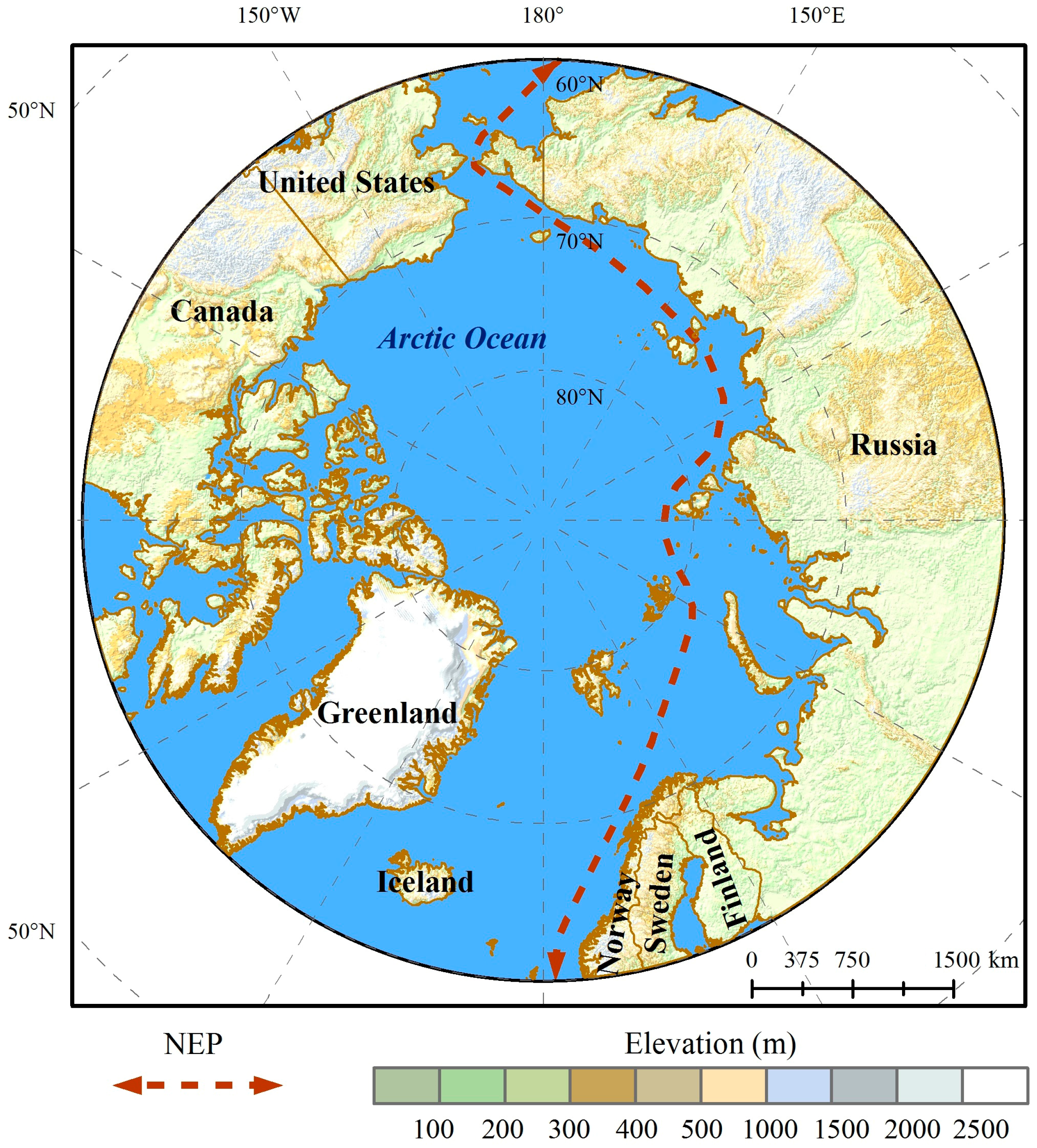
2.1. Research Area
2.2. Data Source and Processing
2.3. Methods
Vessel Flow Calculation Method
3. Results
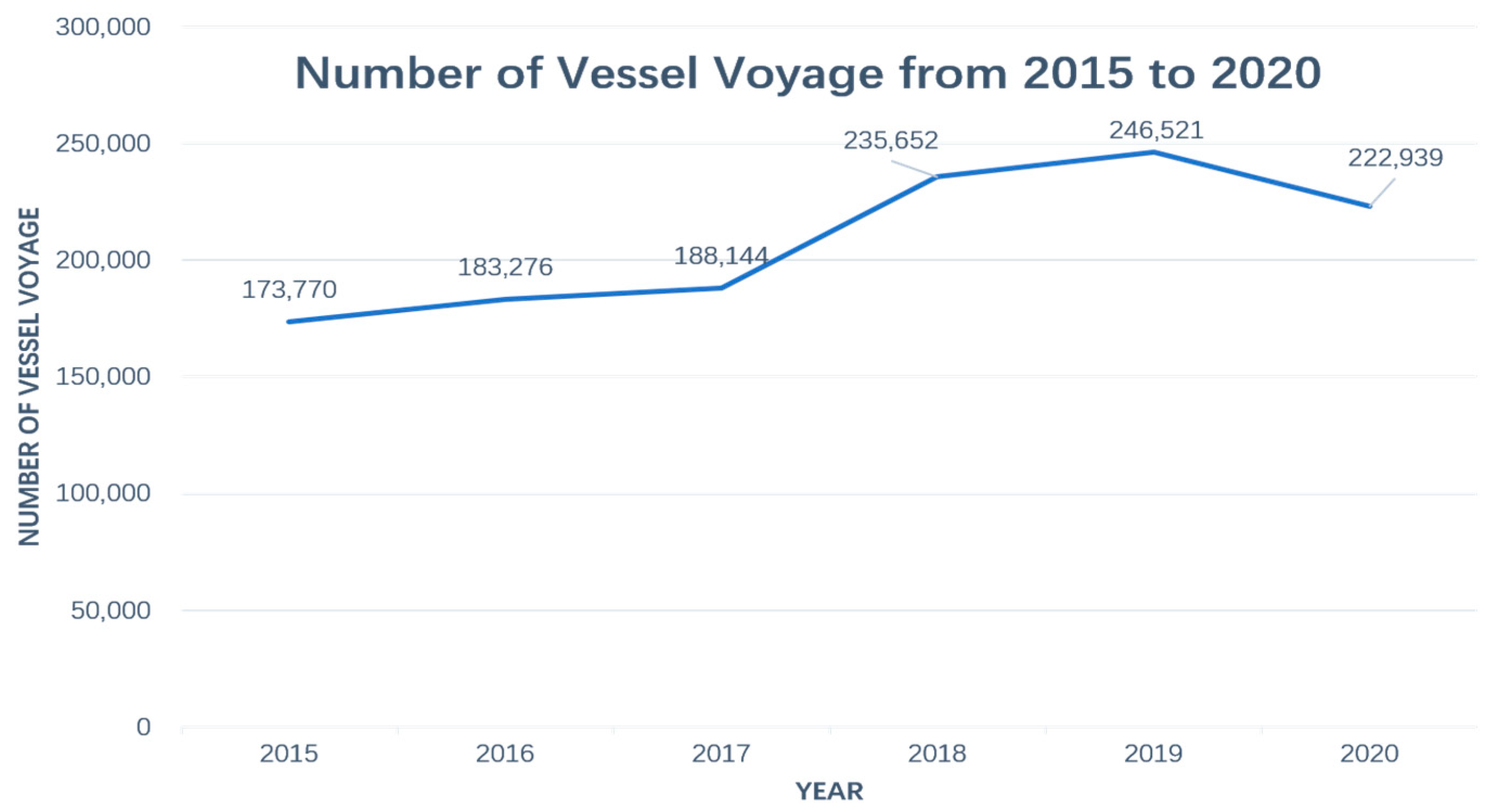
3.1. Spatiotemporal Distribution Characteristics of Vessel Numbers
3.1.1. Monthly Change in Number of Vessels
3.1.2. Quarterly Change in the Number of Vessels
3.1.3. Spatial Distribution of Vessels
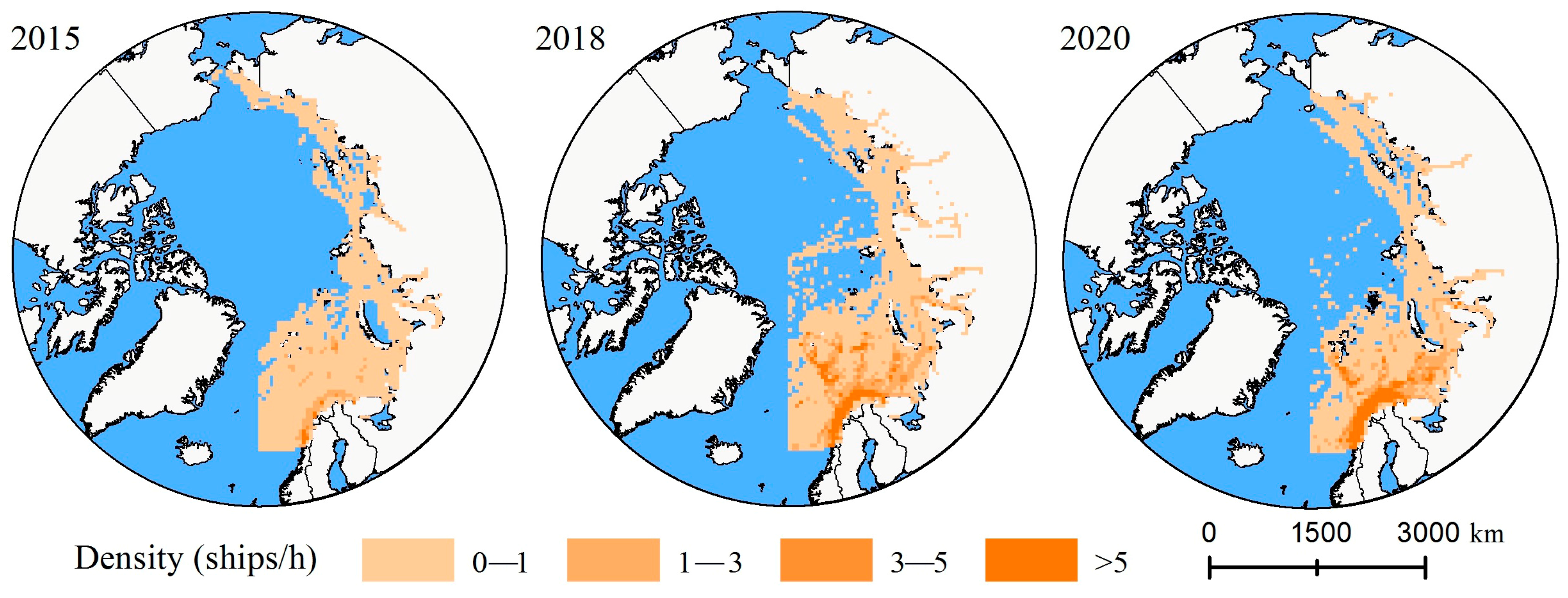
3.1.4. Spatial Distribution of Traffic Flow Density
3.2. Spatiotemporal Distribution Characteristics of Vessel Speed
3.2.1. Temporal Distribution Characteristics of Vessel Speed
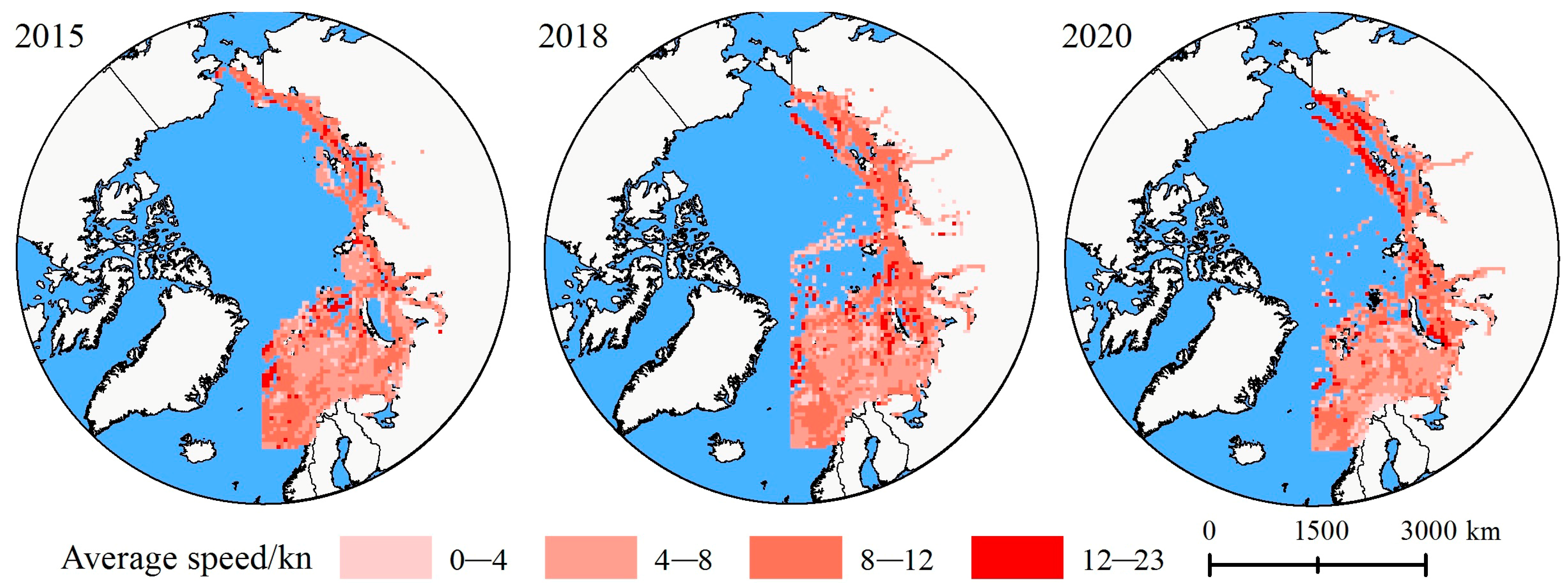
3.2.2. Spatial Distribution Characteristics of Vessel Speed
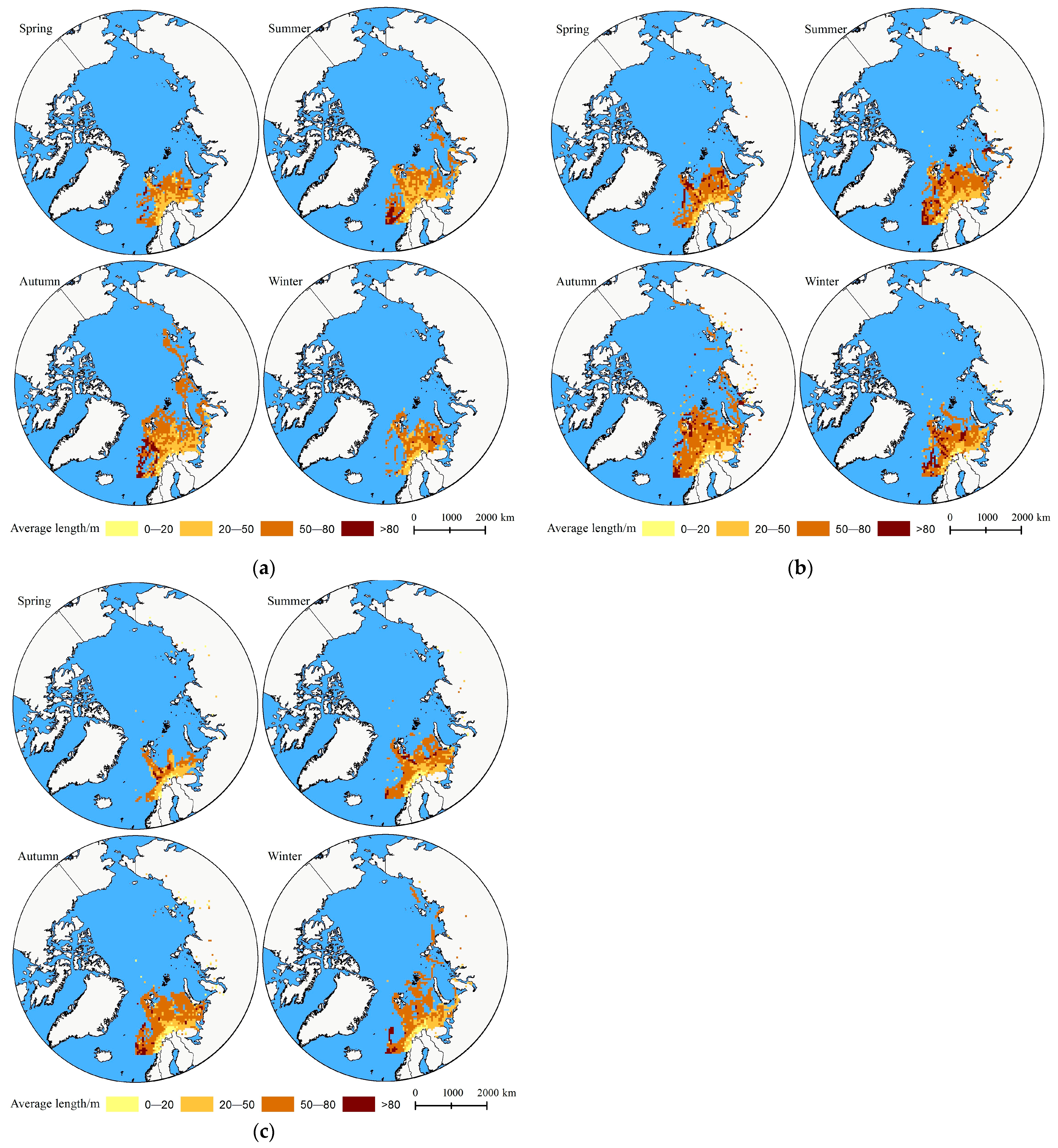
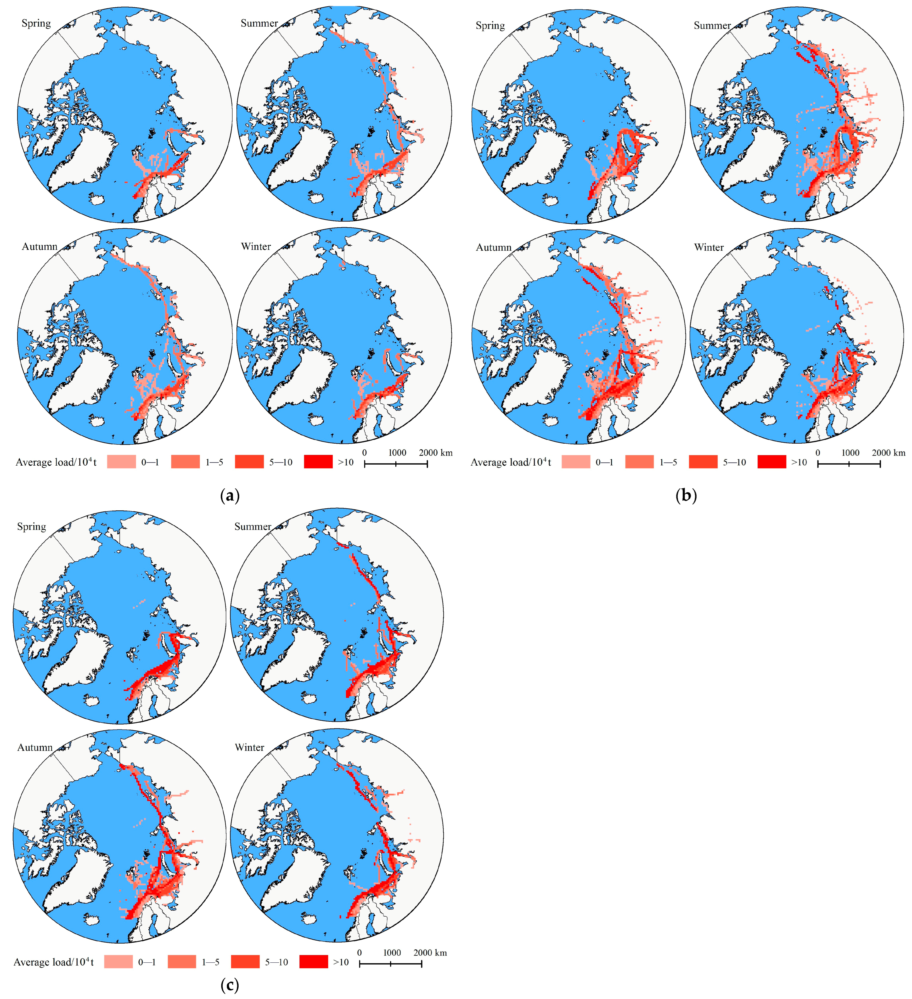
3.3. Spatiotemporal Distribution Characteristics of Vessel Size
3.3.1. Temporal Distribution Characteristics of Vessel Size
3.3.2. Spatial Distribution Characteristics of Vessel Size
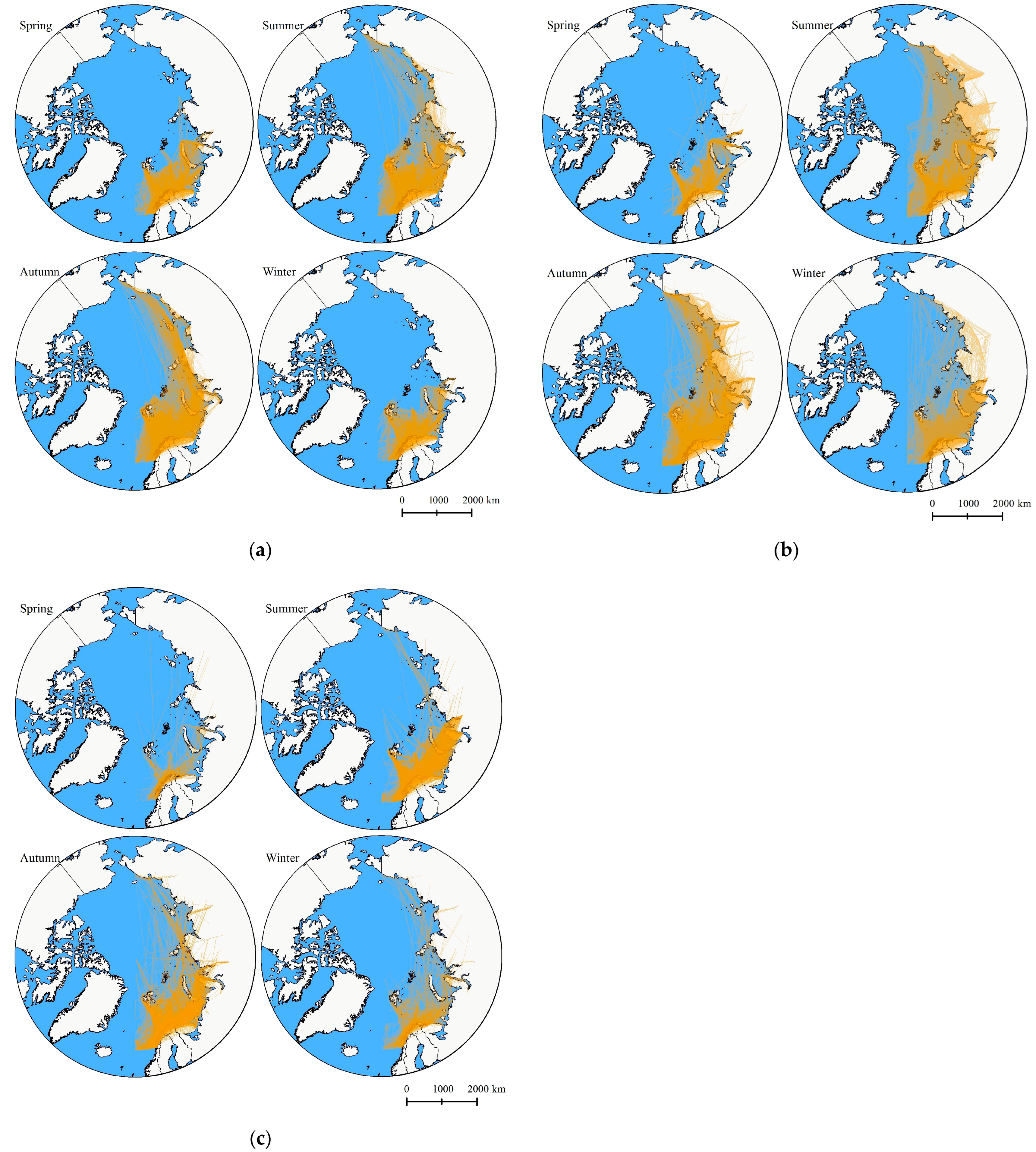
3.4. Spatiotemporal Distribution Characteristics of Vessel Trajectories
3.5. Analysis and Summary
4. Discussion
4.1. Geographic Conditions, Climate Conditions, and Natural Resource Distribution
4.2. Sino–Russian Cooperation and Infrastructure Construction along the Route
4.3. Demand and Supply Factors
5. Conclusions
- (1)
- Strengthen multilateral cooperation and international agreements. The increase in vessel numbers and activity patterns observed in the second stage (starting in 2018) clearly shows that Sino–Russian cooperation in developing the NEP has revitalized the route. In the future, coastal and interested countries should be encouraged to enhance international cooperation by sharing technology, information, and resources to improve the overall efficiency and safety of the route;
- (2)
- Improve infrastructure quality and safety technology for the route. Increase infrastructure construction along the NEP, including port upgrades, enhanced icebreaking services, and improved safety facilities to attract more shipping companies and national vessels. Develop and deploy advanced navigation technologies and monitoring systems to enhance navigation safety in complex sea conditions and low visibility environments;
- (3)
- Optimize economic strategies for the route. Provide tax incentives, financial subsidies, and other incentives to attract investment from shipping companies and international investors, especially in energy, fisheries, and tourism. Encourage diversified use of the route, not limited to cargo transport but also include tourism, scientific research, and other developments to increase the economic value and attractiveness of the route;
- (4)
- Strengthen hull structures. For the NEP, which mainly consists of medium to small-sized vessels, enhance the ice-class standards for these vessels to ensure sufficient ice resistance, significantly improving the safety of vessels on the route.
Author Contributions
Funding
Institutional Review Board Statement
Informed Consent Statement
Data Availability Statement
Conflicts of Interest
References
- Mudryk, L.R.; Dawson, J.; Howell, S.E.; Derksen, C.; Zagon, T.A.; Brady, M. Impact of 1, 2 and 4 °C of global warming on ship navigation in the Canadian Arctic. Nat. Clim. Chang. 2021, 11, 673–679. [Google Scholar] [CrossRef]
- Stephenson, S.R.; Wang, W.; Zender, C.S.; Wang, H.; Davis, S.J.; Rasch, P.J. Climatic responses to future trans-Arctic shipping. Geophys. Res. Lett. 2018, 45, 9898–9908. [Google Scholar] [CrossRef] [PubMed]
- Smith, L.C.; Stephenson, S.R. New Trans-Arctic shipping routes navigable by midcentury. Proc. Natl. Acad. Sci. USA 2013, 110, E1191–E1195. [Google Scholar] [CrossRef] [PubMed]
- Lasserre, F. Case studies of shipping along Arctic routes. Analysis and profitability perspectives for the shipping industry. Polar Sci. 2014, 8, 404–413. [Google Scholar]
- Wu, A.; Che, T.; Xu, Q.; Wang, J.; Zhu, X. Assessing the economic viability of the Arctic Northeast Passage from 2021 to 2065. Int. J. Digit. Earth 2024, 17, 2323182. [Google Scholar] [CrossRef]
- Zhang, Z.; Huisingh, D.; Song, M. Exploitation of trans-Arctic maritime transportation. J. Clean. Prod. 2019, 208, 1227–1236. [Google Scholar] [CrossRef]
- Petrov, A.N.; Tulaeva, S. Socio-economic impacts of Arctic transportation routes: The case of the Northern Sea Route. Local Econ. 2020, 35, 597–615. [Google Scholar]
- Ol’khovik, E.; Tezikov, A. Shipping development trends in the Eastern sector of the Northern Sea Route. In Proceedings of the 26th International Conference on Port and Ocean Engineering under Arctic Conditions, Moscow, Russia, 14–18 June 2021. [Google Scholar]
- Koyama, T.; Nakanowatari, T.; Inoue, J. Information retrieval for Northern Sea Route (NSR) navigation: A statistical approach using the AIS and TOPAZ4 data. Polar Sci. 2021, 27, 100626. [Google Scholar] [CrossRef]
- Kim, D.; Choi, K. Noise pollution in Arctic waters: Sources and mitigation strategies. Environ. Sci. Technol. 2022, 56, 2103–2112. [Google Scholar]
- Silber, G.K.; Adams, J.D. Vessel operations in the Arctic, 2015–2017. Front. Mar. Sci. 2019, 6, 573. [Google Scholar] [CrossRef]
- Chen, Q.; Lau, Y.; Ge, Y.E.; Ng, A.K.Y. Implications of Arctic shipping emissions for marine environment. Marit. Policy Manag. 2022, 49, 155–180. [Google Scholar] [CrossRef]
- Eguíluz, V.M.; Fernández-Gracia, J.; Irigoien, X.; Duarte, C.M. A quantitative assessment of Arctic shipping in 2010–2014. Sci. Rep. 2016, 6, 30682. [Google Scholar] [CrossRef] [PubMed]
- Li, X.; Lynch, A.H. New insights into projected Arctic sea road: Operational risks, economic values, and policy implications. Clim. Chang. 2023, 176, 30. [Google Scholar] [CrossRef] [PubMed]
- Schach, M.; Madlener, R. Impacts of an ice-free Northeast Passage on LNG markets and geopolitics. Energy Policy 2018, 122, 438–448. [Google Scholar] [CrossRef]
- Lee, J.; Kim, Y.H. Ice hazards on the Northern Sea Route: A simulation study. Polar Sci. 2020, 25, 100534. [Google Scholar]
- Vanhatalo, J.; Huuhtanen, J.; Bergström, M.; Helle, I. Probability of a ship becoming beset in ice along the Northern Sea Route—A Bayesian analysis of real-life data. Cold Reg. Sci. Technol. 2021, 184, 103238. [Google Scholar] [CrossRef]
- Yang, X.; Lin, Z.Y.; Zhang, W.J.; Xu, S.; Zhang, M.Y.; Wu, Z.D.; Han, B. Review of risk assessment for navigational safety and supported decisions in arctic waters. Ocean Coast. Manag. 2024, 247, 106931. [Google Scholar] [CrossRef]
- Lynch, A.H.; Norchi, C.H.; Li, X. The interaction of ice and law in Arctic marine accessibility. Proc. Natl Acad. Sci. USA 2022, 119, e2202720119. [Google Scholar] [CrossRef]
- Chen, G.; Huang, L. National policies on the Northern Sea Route and implications for international collaboration. Mar. Policy 2019, 108, 103662. [Google Scholar]
- Bennett, M.M.; Stephenson, S.R.; Yang, K.; Bravo, M.T. The opening of the Transpolar Sea Route: Logistical, geopolitical, environmental, and socioeconomic impacts. Mar. Policy 2020, 121, 104178. [Google Scholar] [CrossRef]
- Kim, J.K. Semi-Continuous Spatial Statistical Analysis Using AIS Data for Vessel Traffic Flow Characteristics in Fairway. J. Mar. Sci. Eng. 2021, 9, 378. [Google Scholar] [CrossRef]
- Ji, M.; Liu, G.; He, Y.; Li, Y.; Li, T. Analysis of Sea Ice Timing and Navigability along the Arctic Northeast Passage from 2000 to 2019. J. Mar. Sci. Eng. 2021, 9, 728. [Google Scholar] [CrossRef]
- MA, X.M. China’s Arctic policy on the basis of international law: Identification, goals, principles and positions. Mar. Policy 2019, 100, 265–276. [Google Scholar] [CrossRef]
- Christodoulou, A.; Dalaklis, D.; Raneri, P.; Sheehan, R. An overview of the legal search and rescue framework and related infrastructure along the Arctic Northeast Passage. Mar. Policy 2022, 138, 104985. [Google Scholar] [CrossRef]
- Galappaththi, E.K.; Falardeau, M.; Harris, L.N.; Rocha, J.C.; Moore, J.S.; Berkes, F. Resilience-based steps for adaptive co-management of Arctic small-scale fisheries. Environ. Res. Lett. 2022, 17, 083004. [Google Scholar] [CrossRef]
- Varnajot, A.; Saarinen, J. ‘After glaciers?’ Towards post-Arctic tourism. Ann. Tour. Res. 2021, 91, 103205. [Google Scholar] [CrossRef]
- Liu, C.; Fan, H.; Dang, X.; Zhang, X. The arctic policy and port development along the Northern Sea route: Evidence from Russia’s arctic strategy. Ocean Coast. Manag. 2021, 201, 105422. [Google Scholar] [CrossRef]


| Year | Season | Cargo Ship | Tanker | Fishing Ship | Passenger Ship | ||||
|---|---|---|---|---|---|---|---|---|---|
| Numbers of Ship | Voyage Number | Numbers of Ship | Voyage Number | Numbers of Ship | Voyage Number | Numbers of Ship | Voyage Number | ||
| 2015 | Winter (December–February) | 228 | 7598 | 65 | 2853 | 425 | 22,954 | 33 | 1947 |
| Spring (March–May) | 197 | 8119 | 65 | 2815 | 434 | 27,162 | 40 | 2419 | |
| Summer (June–August) | 252 | 10,248 | 87 | 3430 | 349 | 26,053 | 60 | 5327 | |
| Autumn (September–November) | 277 | 13,702 | 82 | 4139 | 364 | 32,385 | 39 | 2619 | |
| Total | 474 | 39,667 | 141 | 13,237 | 538 | 108,554 | 68 | 12,312 | |
| 2018 | Winter (December–February) | 350 | 8676 | 159 | 5076 | 942 | 35,009 | 113 | 5137 |
| Spring (March–May) | 98 | 5725 | 35 | 4316 | 418 | 29,330 | 38 | 4533 | |
| Summer (June–August) | 408 | 13,896 | 210 | 7161 | 705 | 35,113 | 145 | 8155 | |
| Autumn (September–November) | 606 | 19,506 | 239 | 7427 | 1028 | 40,325 | 137 | 7267 | |
| Total | 822 | 46,803 | 377 | 23,980 | 1327 | 139,777 | 215 | 25,092 | |
| 2020 | Winter (December–February) | 302 | 2870 | 87 | 739 | 922 | 14,603 | 59 | 1241 |
| Spring (March–May) | 154 | 1788 | 44 | 458 | 501 | 10,599 | 40 | 1176 | |
| Summer (June–August) | 428 | 3989 | 107 | 1259 | 1563 | 19,711 | 120 | 5729 | |
| Autumn (September–November) | 587 | 13,136 | 144 | 3077 | 1953 | 79,783 | 91 | 1781 | |
| Total | 860 | 22,783 | 221 | 5533 | 2343 | 124,696 | 148 | 9927 | |
| Vessel Type | 2015 | 2018 | 2020 | |||||||||
|---|---|---|---|---|---|---|---|---|---|---|---|---|
| Low Speed (0–4 kn) | Medium Speed (4–8 kn) | Mid-High Speed (8–12 kn) | High Speed (12–23 kn) | Low Speed (0–4 kn) | Medium Speed (4–8 kn) | Mid-high Speed (8–12 kn) | High Speed (12–23 kn) | Low Speed (0–4 kn) | Medium Speed (4–8 kn) | Mid-High Speed (8–12 kn) | High Speed (12–23 kn) | |
| Fishing ship (%) | 52.307 | 24.302 | 21.444 | 1.947 | 60.951 | 20.624 | 16.271 | 2.154 | 74.404 | 14.714 | 9.668 | 1.213 |
| Cargo ship (%) | 14.810 | 16.111 | 57.268 | 11.811 | 26.743 | 15.297 | 45.245 | 12.716 | 44.275 | 12.080 | 34.317 | 9.328 |
| Tanker (%) | 20.966 | 16.532 | 42.622 | 19.879 | 27.572 | 14.548 | 35.421 | 22.459 | 24.972 | 12.580 | 35.050 | 27.399 |
| Passenger ship (%) | 11.871 | 8.922 | 31.787 | 47.420 | 18.500 | 8.360 | 31.327 | 41.813 | 51.616 | 8.744 | 21.694 | 17.946 |
| Vessel Type | 2015 | 2018 | 2020 | ||||||||||
|---|---|---|---|---|---|---|---|---|---|---|---|---|---|
| Small | Medium | Large | Mega | Small | Medium | Large | Mega | Small | Medium | Large | Mega | ||
| Fishing ship | Length (m) | 0–20 | 20–50 | 50–80 | >80 | 0–20 | 20–50 | 50–80 | >80 | 0–20 | 20–50 | 50–80 | >80 |
| Proportion (%) | 17.261 | 32.864 | 47.641 | 2.234 | 19.701 | 27.432 | 46.332 | 6.535 | 54.559 | 20.864 | 22.115 | 2.461 | |
| Cargo ship | Load (104 t) | 0–0.5 | 0.5–2 | 2–5 | >5 | 0–0.5 | 0.5–2 | 2–5 | >5 | 0–0.5 | 0.5–2 | 2–5 | >5 |
| Proportion (%) | 54.665 | 29.025 | 9.232 | 7.078 | 40.458 | 42.709 | 9.921 | 6.912 | 49.404 | 35.068 | 7.525 | 8.002 | |
| Passenger ship | Length (m) | 0–50 | 50–100 | 100–150 | >150 | 0–50 | 50–100 | 100–150 | >150 | 0–50 | 50–100 | 100–150 | >150 |
| Proportion (%) | 16.314 | 52.213 | 26.679 | 4.794 | 22.991 | 40.479 | 33.151 | 3.380 | 39.992 | 42.471 | 17.280 | 0.257 | |
| Tanker | Load (104 t) | 0–1 | 1–5 | 5–10 | >10 | 0–1 | 1–5 | 5–10 | >10 | 0–1 | 1–5 | 5–10 | >10 |
| Proportion (%) | 42.506 | 26.764 | 15.128 | 15.601 | 31.475 | 22.015 | 24.223 | 22.287 | 28.933 | 14.403 | 22.762 | 33.902 | |
| Sea Area | Natural Conditions | Characteristics of Vessel Activities |
|---|---|---|
| Barents Sea | Warm pool of the ice sea; the sea temperature is relatively high; abundant oil and gas resources; inflow of the Atlantic Current. | Frequent activities of various types of vessels all year round; more tanker and fishing vessel activity. |
| Kara Sea | Many islands; areas less than 50 m deep account for 40% of the sea; sea ice never melts in some areas all year round. | more suitable for summer navigation |
| Laptev Sea | Polar night lasting 3–5 months; ice-free only in summer; | In addition to being navigable in summer, allowing for navigation with the assistance of icebreakers in autumn. |
| East Siberian Sea | influenced by low pressure, resulting in a short winter. | From May to October is suitable for navigation. |
| Strait | Natural Conditions | Navigation Conditions |
|---|---|---|
| Yugorsky Shar Strait | relatively well-developed navigation aids; strong currents; heavy fog | navigation difficult for small to medium-sized vessels |
| Kara Strait | a short ice period; floating ice year-round | suitable for navigation during the ice-free summer |
| Matochkin Shar Strait | narrow and shallow; | unsuitable for mega vessels |
| Vilkitsky Strait | wide; well-developed navigation aids | suitable for medium to mega vessels in summer as the ice melts |
| Shokal’sky Strait | the central part is narrow; ice conditions are complex | unsuitable for medium to mega vessels; suitable for navigation only in summer |
| Red Army Strait | narrow channels; severe ice conditions; many small islands | no vessels navigate |
| Yana Bay Strait | narrow channels; severe ice conditions; many small islands | no vessels navigate |
| Dmitry Laptev Strait | a shallow area of only 8 m; with floating ice present even in summer | unsuitable for mega vessels; navigation difficult |
| Sannikov Strait | scattered shallow areas; | unsuitable for medium to mega vessels; only suitable for navigation in September |
Disclaimer/Publisher’s Note: The statements, opinions and data contained in all publications are solely those of the individual author(s) and contributor(s) and not of MDPI and/or the editor(s). MDPI and/or the editor(s) disclaim responsibility for any injury to people or property resulting from any ideas, methods, instructions or products referred to in the content. |
© 2024 by the authors. Licensee MDPI, Basel, Switzerland. This article is an open access article distributed under the terms and conditions of the Creative Commons Attribution (CC BY) license (https://creativecommons.org/licenses/by/4.0/).
Share and Cite
Li, C.; Li, Z.; Song, C. The Spatiotemporal Pattern Evolution Characteristics of Ship Traffic on the Arctic Northeast Passage Based on AIS Data. J. Mar. Sci. Eng. 2024, 12, 1508. https://doi.org/10.3390/jmse12091508
Li C, Li Z, Song C. The Spatiotemporal Pattern Evolution Characteristics of Ship Traffic on the Arctic Northeast Passage Based on AIS Data. Journal of Marine Science and Engineering. 2024; 12(9):1508. https://doi.org/10.3390/jmse12091508
Chicago/Turabian StyleLi, Changrong, Zhenfu Li, and Chunrui Song. 2024. "The Spatiotemporal Pattern Evolution Characteristics of Ship Traffic on the Arctic Northeast Passage Based on AIS Data" Journal of Marine Science and Engineering 12, no. 9: 1508. https://doi.org/10.3390/jmse12091508
APA StyleLi, C., Li, Z., & Song, C. (2024). The Spatiotemporal Pattern Evolution Characteristics of Ship Traffic on the Arctic Northeast Passage Based on AIS Data. Journal of Marine Science and Engineering, 12(9), 1508. https://doi.org/10.3390/jmse12091508